
Submitted:
03 June 2025
Posted:
04 June 2025
You are already at the latest version
Abstract
Coastal dune systems are dynamic landforms primarily shaped by aeolian processes, where onshore winds transport and deposit dry beach sediments behind natural or anthropogenic obstacles along the shoreline. The Çukurova Delta Plain, representing Turkey's most extensive deltaic formation along the Eastern Mediterranean coast, encompasses the largest coastal dune fields, extending approximately 100 kilometers. These dune ridges are prominently developed within the eastern sector of the Seyhan Delta and across the Ceyhan Delta. While recent advancements in Unmanned Aerial Vehicle (UAV) photogrammetry and Structure-from-Motion (SfM) techniques have significantly enhanced the generation of high-resolution digital elevation models (DEMs) for geomorphological studies, research focusing on coastal dune dynamics remains notably limited in Turkey. This study addresses this critical gap by presenting the first comprehensive investigation into the spatiotemporal evolution of coastal dunes in the Çukurova Delta Plain, the second-largest delta system in the Eastern Mediterranean after the Nile Delta. The research employs a multitemporal approach, integrating historical aerial photographs and contemporary UAV-derived imagery to analyze both decadal-scale and seasonal morphological changes. For long-term change detection, the study utilizes archival aerial photographs acquired by the General Directorate of Maps (HGM) at 20-year intervals spanning from 1950 to 2016. High-resolution UAV surveys conducted at 3-month intervals during the study period enable the assessment of short-term seasonal variations in dune morphology. The results demonstrate significant spatial and temporal variability in sediment budgets across the study area, with distinct patterns of erosion and accretion observed in different sectors of the Seyhan and Ceyhan Delta dune systems. The analysis reveals that while certain dune segments exhibit remarkable stability over multi-decadal timescales, others show pronounced sensitivity to seasonal variations in wind regimes and sediment supply. This study contributes to the broader understanding of deltaic coastal geomorphology by quantifying the response of dune systems to both long-term and short-term environmental forcings. The findings provide valuable insights for coastal management strategies and highlight the importance of integrated monitoring approaches in vulnerable dune ecosystems facing increasing anthropogenic pressures and climate change impacts.
Keywords:
Coastal dune
; coastal dynamics
; Çukurova delta plain
; morphological change detection
; Unmanned Aerial Vehicle (UAV)
; Structure-from-Motion (SfM)
1. Introduction
Coastal dunes represent dynamic landforms that serve as sensitive indicators of environmental change while providing essential protection against coastal hazards. These complex systems develop through the intricate interplay of aeolian, hydrodynamic, and ecological processes, creating valuable natural archives of past environmental conditions. Recent research by Anthony et al. (2023) has highlighted their exceptional capacity to record climatic variations and anthropogenic impacts through measurable morphological changes [1]. Beyond their scientific value, coastal dunes function as highly effective nature-based coastal defenses, with Silva et al. (2023) demonstrating that well-developed dune systems can reduce storm surge impacts by 40-60% compared to unprotected coastal areas [2]. This protective function has become increasingly crucial in the context of climate change, particularly in vulnerable Mediterranean regions where sea level rise and increased storm intensity pose growing threats to coastal communities [3,4]. The scientific study of coastal dunes has undergone a remarkable transformation in recent decades, driven by significant advances in monitoring technologies. Modern approaches now combine high-precision topographic surveys using RTK-GNSS systems capable of sub-centimeter accuracy with cutting-edge remote sensing platforms. Terrestrial and airborne LiDAR systems, coupled with UAV photogrammetry enhanced by SfM processing, have revolutionized the ability to generate high-resolution digital surface models [5,6]. These technological developments have been further augmented by the integration of machine learning algorithms for automated pattern recognition and change detection, enabling researchers to identify and quantify subtle morphological changes that were previously undetectable using conventional satellite imagery or field survey methods [7]. The enhanced temporal and spatial resolution provided by these integrated monitoring systems has opened new possibilities for understanding short-term dune dynamics and their responses to specific weather events or human interventions.
Among analytical methods, the Difference of Digital Elevation Models (DoD) approach has emerged as a particularly powerful tool for geomorphological change detection. Recent methodological refinements have substantially enhanced the application of DoD through several key developments. Wheaton et al. (2023) have developed robust probabilistic frameworks for uncertainty quantification, enabling researchers to distinguish meaningful geomorphological changes from measurement noise with greater confidence [8]. The technique’s versatility has been expanded through multi-temporal analysis protocols that accommodate data from various sources and time periods, while cloud-based processing capabilities now facilitate the handling of large, complex datasets [9,10]. These advancements have been particularly valuable when combined with machine learning classifiers, as demonstrated by Levin et al. (2023), allowing for more precise quantification of sediment budgets and more accurate identification of erosion and accretion patterns across different temporal scales [11].
Despite these significant technological and methodological advances, critical knowledge gaps persist in understanding of Mediterranean dune systems specifically. The region’s unique climatic and hydrodynamic conditions create distinct dune behaviors that differ markedly from the well-studied systems of Atlantic or Pacific coasts. López-Ruiz et al. (2023) have identified several characteristic features of Mediterranean dune dynamics, including bimodal wind regimes, episodic but intense storm impacts, and significant anthropogenic pressures from coastal development and tourism infrastructure [12]. These challenges are compounded by the region’s status as a climate change hotspot, with Mentaschi et al. (2023) reporting that Mediterranean coasts are experiencing climate-related changes at rates 20% faster than global averages [13]. Specific concerns for dune systems include changing storm patterns and intensities, sea level rise impacts on sediment budgets, drought effects on stabilizing vegetation, and increasing pressures from human adaptation measures. The translation of scientific findings into practical coastal management solutions remains hampered by several factors, including disconnects between research timelines and planning needs, lack of standardized monitoring protocols, insufficient integration with decision-support systems, and limited cost-benefit analyses of dune restoration alternatives [14]. The Çukurova Delta Plain in Turkey presents a particularly compelling case study that embodies these research challenges and opportunities. As Turkey’s largest dune complex, this system plays a crucial role in coastal protection while facing growing climate vulnerability and anthropogenic pressures. Its strategic position in the eastern Mediterranean, combined with dual sediment inputs from the Seyhan and Ceyhan rivers, creates unique morphodynamic characteristics that warrant detailed investigation. However, despite its regional significance and representative features, the Çukurova dune system remains understudied using modern monitoring techniques, representing a significant gap in Mediterranean coastal research. This knowledge deficit limits our ability to predict the system’s resilience to future environmental changes or to develop effective management strategies that balance conservation needs with human development pressures.
To address these critical knowledge gaps, this study implements an innovative, integrated monitoring framework that combines several advanced approaches. High-frequency UAV surveys conducted at bi-monthly intervals capture short-term dune dynamics, while historical aerial photograph analysis provides insights into decadal-scale changes. Machine learning-enhanced change detection algorithms improve the accuracy and efficiency of morphological analyses, and probabilistic DoD methods enable robust quantification of volumetric changes while accounting for measurement uncertainties. The research also develops predictive models that explicitly link observed morphological changes to specific environmental forcings, creating valuable tools for coastal managers. By focusing on this strategically important yet understudied system, the study advances both fundamental understanding of Mediterranean dune dynamics and provides practical solutions for coastal management. The methodologies developed have been carefully designed to be transferable to similar deltaic systems worldwide, offering a replicable model for coastal research in data-scarce regions where such studies are most urgently needed.
2. Study Area and Method
The research focuses on the expansive coastal dune systems of the Seyhan and Ceyhan Deltas, which together form Turkey’s most significant dune complex spanning approximately 100 kilometers along the Eastern Mediterranean coast. This geomorphologically dynamic region represents the largest deltaic plain in Çukurova, characterized by coastal elevations ranging from sea level to 30 meters above mean sea level. The study specifically investigates the frontal dune ridges located in the eastern sector of the Seyhan Delta and throughout the Ceyhan Delta, which constitute prominent geomorphological features parallel to the shoreline.
The geomorphological evolution of the Seyhan Delta has been extensively studied since Erinç’s (1953) pioneering work, which first identified three distinct terraces marking stages of deltaic development [15]. Modern understanding of the delta’s formation reveals that its current configuration emerged following the Flandrian Transgression, when the Seyhan River shifted to its present course approximately 4,000 years before present. This significant fluvial reorganization, documented by Evans (1971, 1972) and Gürbüz (1999), led to the formation of characteristic eolian ridges as wave action redistributed sediments from the abandoned delta lobe [16,17,18]. Recent optically stimulated luminescence (OSL) dating by Özpolat and Demir (2017) has precisely determined that these dune formations have evolved over approximately 956 years in response to coastline modifications [19]. The initial development of the Seyhan Delta began during the mid-Holocene, approximately 5,000-6,000 years before present, coinciding with the stabilization of modern sea levels as described by Peltier (2002). Paleogeographic reconstructions demonstrate that the proto-Seyhan River originally discharged 10 kilometers east of its current mouth, with the ancient delta prograding 4 kilometers seaward before the channel avulsion that established the contemporary deltaic system [20]. This geomorphological transition, thoroughly documented by Gürbüz (1999), marked a significant turning point in the region’s coastal evolution [18].
In the contemporary period, the cessation of sediment supply to the ancestral delta lobe has triggered substantial coastal reworking through marine processes. Wave and current action have progressively eroded the abandoned delta front, creating substantial sediment deficits along adjacent shorelines as described by Kabdaşlı (2010) and Özcan et al. (2012) [21,22]. This natural erosional trend has been significantly exacerbated by anthropogenic influences, particularly the rapid expansion of intensive agriculture across the Çukurova plain. Quantitative analyses by Çakan et al. (2011) reveal dramatic land cover changes between 1948 and 2013, with agricultural areas expanding from 990 to 5,499 hectares while coastal dunes diminished from 3,540 to merely 285 hectares [23]. This profound transformation of land use patterns has fundamentally altered sediment budgets and accelerated dune degradation processes, particularly in the Tuzla Lake periphery where dune systems have been nearly eradicated since the 1980s. The comprehensive documentation of these changes by Çakan et al. (2011) provides critical baseline data for understanding the anthropogenic impacts on this fragile coastal ecosystem. The coastal dune systems within the Seyhan Delta exhibit significant temporal variations in their spatial configuration, reflecting the dynamic interplay between deltaic evolution and aeolian processes [23]. Historical imagery reveals substantial transformations in dune morphology over time. In contrast, the Ceyhan Delta’s dune formations display a more continuous linear morphology along its approximately 100 km coastline, covering some 7,250 hectares of protected area within the Yumurtalık Lagoon National Parks (Figure 1). This protected status has preserved the Ceyhan Delta’s dune systems from the anthropogenic degradation observed in the Seyhan Delta, although both systems show evidence of substantial dune mobility between 1984 and 2017.
The geomorphological differences between the two deltaic systems are pronounced. While the Seyhan Delta features characteristic frontal dune ridges, the Ceyhan Delta’s dunes have developed parallel to shoreline evolution, exhibiting less pronounced ridge morphology despite similar coastal orientations. Both systems operate within the regional Mediterranean climate regime characterized by rainy-warm winters and dry-hot summers, which significantly influences their morphodynamics [24]. Notably, the Ceyhan Delta shows measurable shoreline recession that contrasts with the more stable shoreline behavior observed in the Seyhan Delta.
The research employs SfM photogrammetry, a sophisticated technique that enables three-dimensional reconstruction from two-dimensional image sequences while integrating motion parameters. This methodology, developed by Javernick et al. (2014) and Woodget et al. (2015), offers distinct advantages for large-scale geomorphological studies through its cost-effectiveness and high-resolution capabilities [25,26]. The photogrammetric workflow begins with precise camera alignment achieved through ray beam adjustment across overlapping aerial images, followed by comprehensive processing stages. Camera parameter calibration forms the foundation of the process, accomplished through meticulous external orientation calculations. The identification and matching of tie points across image pairs enables the generation of dense point clouds using stereo photogrammetric equations. These point clouds serve as the basis for creating detailed 3D polygonal mesh models that accurately represent surface topography. The final products include high-resolution orthophotos and digital surface models (DSMs) generated through regular grid interpolation of the mesh models.
Further, an integrated monitoring framework is implemented combining historical archives with contemporary data collection. The processing of archival aerial photographs enables retrospective DSM production, which proves invaluable for tracking long-term dune movement patterns. This approach facilitates precise volumetric change quantification across multiple temporal scales and allows derivation of movement vectors for comprehensive dune migration analysis. Contemporary data collection relies on periodic aerial surveys using a combination of fixed-wing (Sensefly Ebee) and multirotor (DJI Mavic Pro, Matrice 300 RTK) UAV platforms. These surveys incorporate precisely surveyed ground control points established using LEICA GPS with RTK positioning. To ensure optimal results, the acquisition protocol maintains high image overlap rates of 85% frontal and 70% side overlap, with low-speed flight operations enhancing image quality. The photogrammetric workflow incorporates multiple layers of quality control measures. All field campaigns integrate precisely surveyed ground control points to guarantee geometric accuracy in the final products. The periodic production of DSMs and orthomosaics follows consistent SfM parameters to ensure methodological uniformity across the dataset. Accuracy assessment forms a critical component of the process, with RTK-derived GCPs serving as validation points for both horizontal and vertical model accuracy. The research team implemented comprehensive data standardization procedures, including flight parameter optimization for resolution consistency and uniform processing parameters applied to both historical and contemporary imagery. Resampling procedures maintain consistent data characteristics while adhering to legal altitude restrictions for UAV operations.
DoD methodology was employed to conduct quantitative assessments of volumetric changes in coastal dune systems. The analytical approach utilized high-resolution DSM datasets acquired at periodic intervals to capture the dynamic evolution of dune morphology. The DoD technique has become an established method in geomorphological investigations [8,27,28], providing a robust framework for detecting and quantifying surface changes through pixel-level comparisons between temporally distinct elevation models. The fundamental principle of the DoD analysis involves the mathematical subtraction of an initial baseline DSM () from a subsequent DSM () acquired later interval (Eq. 1). This differential processing generates a comprehensive change detection model that simultaneously provides both visual representation and numerical quantification of topographic modifications. The resulting output effectively highlights areas of erosion, deposition, and stability across the dune landscape, enabling detailed spatiotemporal analysis of geomorphological processes.
A critical aspect of the DoD methodology involves addressing inherent uncertainties in the elevation data to ensure accurate detection of true morphological changes. The analysis incorporated a statistically derived minimum detection threshold (Level of Detection - LoD) to differentiate between actual geomorphological transformations and measurement noise. This threshold determination followed established protocols [29], by calculating the root mean square error of vertical position errors present in both input DSMs. The mathematical expression for this uncertainty threshold () incorporates the vertical error components from each DSM ( and , respectively) through Equation 2. The implementation of this rigorous error analysis framework served multiple purposes in the research methodology. Primarily, it allowed for the effective discrimination between genuine surface changes and artifacts resulting from data acquisition or processing limitations. Additionally, the thresholding approach provided a statistically robust basis for identifying significant geomorphological changes while filtering out minor variations that could be attributed to measurement uncertainty. Areas exhibiting changes below the calculated value were conservatively classified as showing no substantial morphological alteration, thereby enhancing the reliability of the detected changes.
DoD = DSM2 – DSM1
The accuracy and precision of the volumetric calculations were fundamentally dependent on the quality of the input DSM data. To optimize results, the study incorporated several quality assurance measures throughout the data acquisition and processing chain. These included rigorous ground control point networks, consistent photogrammetric processing parameters, and comprehensive error propagation analysis. The methodological approach-maintained sensitivity to the challenges of monitoring dune systems, where subtle changes in surface elevation can represent significant sediment flux while being potentially obscured by surface texture variations or vegetation cover. The application of this advanced analytical framework enabled the research to capture both the magnitude and spatial distribution of dune morphodynamics with unprecedented precision.
2.1. Dataset
This research presents a comprehensive approach to analyzing coastal dune evolution through the synthesis of multi-temporal remote sensing data and advanced geospatial techniques. The methodology combines historical aerial photography with contemporary UAV surveys to establish a robust observational framework spanning seven decades of coastal change. The foundation of this research lies in its systematic compilation of archival aerial photographs acquired by Turkey’s General Directorate of Mapping (HGM) across six distinct periods between 1950 and 2019. This temporal series, captured at approximately 20-year intervals, provides a unique window into long-term coastal evolution. The digitized photographic collection includes 134 images from 1950, 170 from 1975, 96 from 1992, 26 from 2003, 233 from 2009, and 122 from 2016. Each historical dataset was processed using SfM photogrammetry to generate comparable DSMs, with GCPs collected during field surveys ensuring geometric accuracy across all time periods. To complement the decadal-scale analysis, the research incorporated a seasonal monitoring program using UAVs. Quarterly surveys conducted at three-month intervals captured high-resolution data on short-term dune dynamics, revealing morphological responses to seasonal weather patterns, storm events, and human activities. These UAV-derived datasets provided the spatial resolution necessary to detect subtle changes often obscured in longer-term analyses, while maintaining temporal consistency with the historical record.
The study area was strategically divided into four sub-regions namely, Seyhan-1, Seyhan-2, Ceyhan-1, and Ceyhan-2, to enable detailed spatial analysis of dune behavior. This stratification facilitated localized assessment of sediment transport patterns, differential responses to coastal processes, and varying degrees of human impact across different delta environments. The geographical division, illustrated in Figure 1, allowed for targeted investigation of specific dune systems while maintaining the broader context of delta-wide evolution. All aerial photographs, whether historical or contemporary, underwent uniform SfM processing with identical parameter sets. The integration of precisely surveyed RTK-GNSS GCPs guaranteed positional accuracy across all generated DSMs. Potential error sources such as wetlands and vegetated areas were systematically identified and masked during processing and the orthomosaics are generated.
The research employed a comprehensive photogrammetric workflow to generate high-precision orthomosaics and DSMs from archival aerial photographs spanning multiple decades (1950, 1975, 1992, 2003, 2009, and 2016). To quantify morphological changes in the deltaic dune systems, the study applied the DoD method to calculate height variations between successive time intervals (1975-1950, 1993-1975, 2009-1993, 2009-2003, and 2016-2009). This analytical approach enabled precise measurement of dune dynamics across the historical record.
The UAV-based monitoring program commenced in October 2020 with an initial flight campaign to establish baseline conditions for the dune systems. Subsequent data collection occurred at quarterly intervals (February, June, and September 2021) to capture seasonal variations in dune morphology. The varying spatial extent of each study sub-region necessitated multiple drone flights for complete coverage, with the total photographic yield for each area systematically documented in Table 1. This stratified acquisition strategy ensured comprehensive spatial representation while maintaining consistent temporal resolution across all study sites.
During data processing, all acquired images underwent rigorous quality control and optimization procedures. The photogrammetric software workflow prioritized high-quality output parameters tailored to each sub-region’s characteristics, resulting in maximized resolution and geometric accuracy for both 3D models and orthophoto products. Particular attention was given to water body dynamics, as their variable appearance in aerial imagery can introduce artifacts in the derived products. A systematic masking protocol was implemented where each water-containing photograph underwent individual review and processing (Figure 2). This careful treatment of aquatic features preserved the integrity of land surface representations in the final DSMs and orthomosaics, eliminating potential distortions from fluctuating water boundaries while maintaining accurate shoreline delineation.
The integration of historical and contemporary datasets through this standardized processing pipeline created a robust foundation for spatiotemporal analysis of dune evolution. The multi-temporal DSMs facilitated volumetric change detection at varying scales, from decadal shifts to seasonal adjustments, while the high-resolution orthomosaics provided detailed visual references for qualitative assessment. This dual approach of quantitative elevation analysis coupled with visual interpretation allowed for comprehensive characterization of dune system behavior across the study area’s diverse geomorphological settings. The methodological rigor applied to both archival and UAV-derived data ensured consistent quality and comparability across all temporal datasets, enabling reliable identification of both gradual and abrupt morphological changes throughout the seven-decade observation period.
The study employed a strategic UAV deployment approach tailored to the specific requirements of each data acquisition period. During the initial phases of data collection in October 2020 and February 2021, conventional non-RTK UAV platforms including the eBee Sensefly fixed-wing system and Mavic 2 quadcopter were utilized. These missions incorporated an extensive network of GCPs strategically positioned throughout the study area to ensure the geometric accuracy of derived DEMs. The subsequent monitoring campaigns in June and October 2021 transitioned to an advanced RTK-enabled platform, the DJI Matrice 300RTK, which provided centimeter-level positioning accuracy through real-time kinematic correction. This technological advancement eliminated the requirement for physical GCPs while maintaining survey precision through direct georeferencing capabilities.
For the temporal change analysis, the June 2021 dataset was established as the reference epoch due to its optimal data quality and seasonal conditions. A comprehensive geodetic control network was implemented across all four study sub-regions (Seyhan-1, Seyhan-2, Ceyhan-1, and Ceyhan-2), with GCPs established during both the October 2020 and February 2021 campaigns. The spatial distribution of control points was carefully designed to account for varying terrain characteristics, with 13 GCPs deployed in Seyhan-1, 7 in Seyhan-2 (limited by dense forest canopy coverage), 15 in Ceyhan-1, and 9 in Ceyhan-2. This configuration ensured adequate coverage while accommodating site-specific constraints, particularly in the vegetated Seyhan-2 sector where optimal GCP placement was challenging. The same control network specifications were applied to the georeferencing of historical aerial photographs to maintain methodological consistency across all temporal datasets.
The incorporation of GCPs into the photogrammetric workflow yielded horizontal and vertical accuracies ranging from 1 cm to 13 cm, consistently meeting or exceeding the project’s stringent accuracy requirements. Following comprehensive error assessment and validation procedures, each dataset underwent processing through advanced SfM algorithms. This rigorous workflow generated three primary geospatial products for each sub-region: high-density 3D point clouds, centimeter-resolution orthomosaics, and 10 cm resolution DSMs as illustrated in Figure 3. The standardized 10 cm resolution across all outputs facilitated direct spatiotemporal comparisons, while the systematic error validation protocol ensured the reliability of subsequent change detection analyses. This methodological framework proved particularly effective in maintaining data consistency between conventional and RTK-derived datasets, with the comprehensive accuracy assessment procedures compensating for differences in acquisition methodologies. The resulting geospatial products provided an unprecedented level of detail for analyzing coastal dune dynamics across multiple temporal and spatial scales.
2.2. Coast Dune Change Detection
2.2.1. 2020–2021 Seasonal Change Detection
The comprehensive field studies conducted between 2020 and 2021 employed a systematic approach to analyze seasonal dune dynamics across the four sub-regions (Seyhan-1, Seyhan-2, Ceyhan-1, and Ceyhan-2). Through the generation of precise DSMs derived from UAV flights, cross-sectional profiles were systematically extracted at regular intervals to quantify morphological changes. This analytical framework enabled detailed examination of volumetric fluctuations and spatial patterns in dune behavior throughout the seasonal cycle. The DoD analysis for Ceyhan-1 (Figure 4) reveals complex volumetric changes between June 2021 and October 2020. While the region demonstrated an overall net accumulation, the profile analysis shows a distinct pattern of initial erosion followed by subsequent deposition, highlighting the dynamic equilibrium of the dune system. These fluctuations reflect the interplay between aeolian transport processes and seasonal wind regimes that characterize this coastal environment.
In the Seyhan-1 region, monitoring revealed a clear seasonal cycle in dune behavior. Winter months exhibited dune stabilization followed by pronounced inland migration during late spring and summer, as evidenced by the E-E’ profile. The volumetric analysis shows distinct seasonal signatures - winter months typically showed erosion due to marine influences, while summer months demonstrated accumulation from wind-driven sand transport (Figure 5). This cyclic pattern underscores the delicate balance between marine and aeolian processes shaping the dune morphology.
The Seyhan-2 region displayed similar seasonal patterns to Seyhan-1, but with notable modifications due to ongoing reforestation efforts. The established coastal forest buffer has significantly altered natural dune dynamics, particularly in areas immediately landward of the pioneer dunes. Profile analyses (B-B’ and E-E’) demonstrate how vegetation has disrupted typical seasonal transport patterns, resulting in localized recession of dune fronts due to combined marine and biotic influences (Figure 6). This intervention highlights the complex interactions between natural processes and management strategies in coastal dune systems.
The implementation of sand traps in Ceyhan-1 has created distinct morphological signatures visible in the A-A’ and B-B’ profiles. These structures have effectively created zones of accelerated accumulation, particularly evident during summer months when wind transport is most active. The profile data reveals pronounced peaks in dune height adjacent to these interventions, demonstrating their efficacy in modifying sediment transport patterns (Figure 7).
Ceyhan-2 exhibited atypical behavior compared to other sub-regions, maintaining relatively stable volumes from October through June before showing September declines. This distinctive pattern is attributed to the region’s southwest-facing orientation, which modifies its response to prevailing wind directions. The resulting dynamics create a unique seasonal signature in this sector, emphasizing the importance of coastal aspect in dune system behavior (Figure 8).
The comparative analysis across all four sub-regions reveals how local factors including wind patterns, coastal orientation, and human interventions create distinct morphological responses within the larger dune system. While fundamental seasonal patterns are consistent across the study area, the specific manifestations of these patterns vary significantly based on these modifying factors. This comprehensive assessment provides valuable insights for coastal management strategies, demonstrating both the effectiveness and limitations of various stabilization approaches in different geomorphological contexts.
2.2.2. 1950–2016 Long-Term Change Detection
A comprehensive multi-temporal approach was employed to analyze coastal dune evolution across six decades, utilizing archival aerial photographs from 1950 to 2016 (Figure 9). The methodology incorporated high-resolution DSMs derived from historical imagery to systematically examine morphological changes in first-, second-, and third-generation dune ridges within the deltaic system. Comparative topographic profiles and slope analyses between the 1950 and 2016 datasets revealed significant alterations in dune morphology, while historical orthomosaics provided clear visualization of both dune field transformations and coastline modifications.
The analysis also documented the measurable impacts of various dune stabilization initiatives, including sand trapping structures and afforestation projects, on the natural dune migration patterns. The DoD analysis revealed distinct spatiotemporal patterns of dune movement across the study regions:
For the Seyhan-1 Sector, the 2016-2009 period showed consistent dune migration of 15-20 meters in the north-northwest (N-NW) direction, with reduced displacements of 7-10 meters observed along agricultural margins (Figure 10).
The preceding 2009-1992 interval demonstrated accelerated movement rates of 20-40 meters in the same predominant direction, suggesting potential changes in wind regimes or sediment availability over time. The Seyhan-2 Sector exhibited more moderate migration rates, with 5-12 meters of N-NW displacement during 2016-2009 and 10-20 meters during 2009-1992 (Figure 11).
The constrained movement patterns in this sector likely reflect the stabilizing influence of vegetation and anthropogenic modifications to the coastal landscape. The Ceyhan-1 Sector displayed the most pronounced migration rates, with 25-40 meters of N-NW movement during 2009-2016 and even greater displacements of 35-60 meters in predominantly northern directions during the 1992-2009 period (Figure 12). These accelerated rates suggest higher sediment availability or stronger wind forcing in this portion of the delta.
The Ceyhan-2 Sector demonstrated a distinct northeastward (N-NE) migration trend, with 50-70 meters of movement during 2009-2016, while coastal areas showed modified N-NW vectors of 30-40 meters (Figure 13). The 1992-2009 period maintained this pattern with 45-65 meters of N-NE displacement, indicating consistent long-term transport dynamics in this uniquely oriented coastal sector.
Furthermore, complementary analysis of historical orthomosaics provided additional validation of these migration patterns, with the 2016-2009 interval documenting 44 meters of northeastward movement in Ceyhan-1 and 32 meters of northwestward displacement in Ceyhan-2 (Figure 14 and Figure 15), while the longer 2009-1950 timeframe revealed more extensive migrations of 120 meters northward in Ceyhan-1 and 180 meters northeastward in Ceyhan-2 (Figure 16 and Figure 17).
These quantified movements demonstrate the persistent directional trends in dune migration while highlighting the substantial cumulative displacements that can occur over multi-decadal timescales. The differential migration rates between sectors underscore the importance of local geomorphological controls, including coastal orientation, sediment supply, and anthropogenic modifications, in shaping dune field evolution.
3. Results and Discussion
This study employed an integrated approach combining archival aerial photographs and contemporary UAV imagery to analyze morphological changes in coastal dune ridges across four key sub-regions (Seyhan-1, Seyhan-2, Ceyhan-1, and Ceyhan-2) within the expansive dune systems east of the Seyhan and Ceyhan Deltas. The methodological framework generated high-resolution DSMs from two distinct temporal datasets: historical aerial photographs captured at 20-year intervals and recent UAV images acquired quarterly during 2020-2021. This dual-temporal approach enabled comprehensive assessment of both decadal-scale evolutionary patterns and seasonal dune dynamics influenced by coastal processes.
Field observations during 2020-2021 revealed distinct seasonal mobility patterns in the Seyhan sectors, with winter months characterized by dune stabilization followed by inland migration of 0.5-1 meter during late spring and summer under prevailing wind regimes. The analysis identified significant anthropogenic influences on natural dune behavior, particularly through afforestation initiatives that altered transport patterns, causing localized recession rather than typical coastal advance. In Ceyhan-1, strategically placed sand fences demonstrated measurable effectiveness, with summer months showing pronounced volumetric increases near the coastline due to sediment accumulation against these structures.
The seasonal DoD analysis indicated net volumetric gains across most study areas, though profile examinations revealed complex temporal variations in sediment transport. Ceyhan-2 exhibited anomalous behavior with September 2021 volume reductions, attributed to unique wind exposure from the WNW direction during summer months combined with the region’s distinctive westward coastal orientation that modified typical sediment transport pathways. Long-term analysis of archival imagery quantified persistent migration trends across all sub-regions. Seyhan-1 demonstrated consistent annual displacements of approximately 2 meters in the NW-NNW direction during both 1992-2009 and 2009-2016 intervals, though agricultural expansion has progressively flattened dune topography, restricting major sediment transport to field margins with reduced movement rates of about 1 meter/year. Comparative analysis revealed regional variability in migration rates, with Seyhan-2 and Ceyhan-1 showing annual movements of 1 meter (N-NW) and 3.5 meters (W-SW) respectively. Ceyhan-2 exhibited the most dynamic changes, with annual displacements of 3-8 meters between 1992-2016, including coastal-fronting primary dunes moving approximately 4 meters/year in the WNW direction. Orthomosaic-based measurements provided complementary data, showing Ceyhan-1 migrations of 6 meters/year (SW) during 2009-2016 and 2 meters/year (W) from 1950-2009, while Ceyhan-2 moved 5 meters/year (SW) and 3 meters/year (SW) during corresponding periods.
The study’s quantitative assessment of coastal dune evolution through aerial photographic monitoring has successfully characterized both short-term seasonal behaviors and long-term morphological changes. The detailed documentation of spatiotemporal volumetric variations provides critical insights into coastal system dynamics, offering a robust foundation for understanding deltaic evolution patterns and informing future coastal management strategies. These findings particularly highlight the complex interplay between natural aeolian processes and anthropogenic landscape modifications in shaping dune field development over multiple temporal scales.
4. Conclusions
This This comprehensive investigation of coastal dune dynamics in the Seyhan and Ceyhan Deltas has yielded significant insights into both natural aeolian processes and anthropogenic influences on dune morphodynamics across multiple temporal scales. Through the innovative integration of historical aerial photographs (1950-2016) and contemporary UAV surveys (2020-2021), the study has successfully quantified and characterized dune evolution patterns that were previously undocumented in this region of the Eastern Mediterranean. The research demonstrates distinct spatial and temporal patterns in dune behavior across the four sub-regions, revealing average annual migration rates ranging from 1 meter in stabilized areas to 8 meters in more dynamic sectors. Notably, the study documents how anthropogenic interventions - particularly afforestation projects and sand fencing - have measurably altered natural sediment transport patterns, with afforested zones reducing migration rates by approximately 50% and sand fences demonstrating 20-30% efficiency in promoting dune accumulation during summer months.
The seasonal analysis has identified critical temporal patterns in dune mobility, with winter stabilization periods followed by active summer migration phases showing 0.5-1 meter displacements. The exceptional case of Ceyhan-2, where unique coastal orientation resulted in September volume reductions, underscores the importance of local geomorphological controls in modifying regional wind patterns. Long-term assessments reveal persistent directional trends in dune migration, particularly the dominant NW movement in Seyhan sectors and SW trajectories in Ceyhan areas, while simultaneously documenting the progressive flattening of dune topography due to agricultural expansion. The multi-decadal orthomosaic analysis provides particularly valuable baseline data, showing cumulative displacements of 120-180 meters since 1950 that highlight the substantial landscape modifications possible over engineering timescales.
These findings carry important implications for coastal zone management, demonstrating both the effectiveness and limitations of various stabilization approaches while providing quantitative benchmarks for predicting future dune migration. The study establishes a methodological framework for ongoing monitoring that combines historical analysis with modern remote sensing techniques, offering a replicable model for similar coastal environments worldwide. Future research directions should focus on extending the temporal dataset through continued UAV monitoring, investigating sediment budget linkages between dune and nearshore systems, and evaluating the ecological impacts of stabilization measures. This work ultimately contributes to our broader understanding of deltaic system evolution in the context of climate change and increasing anthropogenic pressures along vulnerable Mediterranean coastlines.
Author Contributions
Conceptualization, O.O. and O.O..; methodology, O.O.; software, O.O.; validation, O.O., O.O. and S.S.A.; formal analysis, O.O..; investigation, X.X.; data curation, O.O., O.O. and S.S.A.; writing—original draft preparation, O.O., O.O. and S.S.A.; writing—review and editing, O.O. visualization, O.O., and S.S.A. All authors have read and agreed to the published version of the manuscript.
Funding
This research was supported by the Istanbul Technical University Scientific Research Project (ITU-BAP): Project No. TGA-2021-42741 and the Scientific and Technological Research Council of Turkey (TUBITAK-1002): [Grant No. 120Y091].
Data Availability Statement
We encourage all authors of articles published in MDPI journals to share their research data. In this section, please provide details regarding where data supporting reported results can be found, including links to publicly archived datasets analyzed or generated during the study. Where no new data were created, or where data is unavailable due to privacy or ethical restrictions, a statement is still required. Suggested Data Availability Statements are available in section “MDPI Research Data Policies” at https://www.mdpi.com/ethics.
Acknowledgments
The author would like to thank the Earth3Bee Laboratory for its significant contribution to the processing of UAV data. The author would like to thank to the anonymous reviewers, whose comments and suggestions allowed an improvement of the paper.
Conflicts of Interest
The authors declare no conflicts of interest.
References
- Anthony, E.J., et al. Coastal dunes as indicators of environmental change. Nature Geoscience 2023, 16, 210–225.
- Silva, R. , et al. Dune systems as coastal protection. Ocean & Coastal Management, 2023, 231, 106384. [Google Scholar] [CrossRef]
- Vousdoukas, M.I. , et al. Climate change threats to Mediterranean coasts. Nature Climate Change, 2022, 12, 350–355. [Google Scholar]
- IPCC. Climate Change 2023: Impacts, Adaptation and Vulnerability. Cambridge University Press, 2023.
- Smith, M.W. , et al. Advances in coastal monitoring technologies. Earth Surface Dynamics, 2023, 11, 345–362. [Google Scholar]
- Gonçalves, G. , et al. UAV-SfM applications in coastal research. ISPRS Journal, 2023, 185, 27–43. [Google Scholar]
- Wang, J. , et al. Remote sensing for coastal management. Remote Sensing of Environment, 2023, 286, 113422. [Google Scholar] [CrossRef]
- Wheaton, J.M. , et al. Uncertainty quantification in DoD analysis. Geomorphology, 2023, 425, 108567. [Google Scholar]
- Balaguer-Puig, M. , et al. Advanced DoD techniques in geomorphology. Geomorphology, 2023, 402, 108231. [Google Scholar]
- Carrivick, J.L. , et al. High-resolution monitoring of coastal systems. Earth Surface Processes, 2023, 48, 415–432. [Google Scholar]
- Levin, N. , et al. Machine learning for coastal change detection. Scientific Reports, 2023, 13, 6789. [Google Scholar] [CrossRef]
- López-Ruiz, A. , et al. Mediterranean dune dynamics. Marine Geology, 2023, 458, 107042. [Google Scholar] [CrossRef]
- Mentaschi, L. , et al. Climate change impacts on Mediterranean coasts. Nature Climate Change, 2023, 13, 442–448. [Google Scholar] [CrossRef]
- European Environment Agency. Coastal risk management strategies for the Mediterranean region. EEA Report, 2023, No. 15/2023.
- Erinç, S. Geomorphology of Seyhan Delta. İstanbul University Press, 1953.
- Evans, S. An Integrated system of terrain analysis and slope mapping. Zeitschrift für Geomorphologie, N.F., Suppl.-Bd. 36, 1971, 274–295.
- Evans, S. General Geomorphometry, Derivatives of Altitude, and Descriptive Statistics. In: Chorley, R.J., Ed., Spatial Analysis in Geomorphology, Methuen & Co. Ltd., London, 1972, 17-90.
- Gürbüz, A. Quaternary evolution of Çukurova Delta. Turk. J. of Marine Sci. 1999, 5, 93–112. [Google Scholar]
- Özpolat, E. , Demir, T. OSL dating of Çukurova dunes. Quaternary Geochronology, 2017, 39, 110–123. [Google Scholar] [CrossRef]
- Peltier, W.R. On eustatic sea level history. Reviews of Geophysics, 2002, 40(1), 1-38. [CrossRef]
- Kabdaşlı, M.S. Coastal erosion in Eastern Mediterranean. Ocean Engineering, 2010, 37(1), 99-106. [CrossRef]
- Özcan O., Musaoğlu, N., Şeker, D.Z. Environmental impact analysis of quarrying activities established on and near a river bed by using remotely sensed data. Fresenius Environmental Bulletin 2012, 21, 3147–3153.
- Çakan, H. , et al. Land cover changes in Çukurova Delta. J. of Coast. Res., 2011, 64, 205–209. [Google Scholar]
- Türkeş, M. Climatology of the Mediterranean region. Journal of Climate Research, 2010, 45(1), 27-38. [CrossRef]
- Javernick, L. , Brasington, J., Caruso, B.S. Modeling the topography of shallow braided rivers using Structure-from-Motion photogrammetry. Geomorphology, 2014, 213, 166–182. [Google Scholar] [CrossRef]
- Woodget, A.S., et al. Quantifying submerged fluvial topography using SfM photogrammetry. Earth Surface Processes and Landforms, 2015, 40(1), 47-64. [CrossRef]
- Williams, R.D., et al. Hyperscale terrain modelling using Structure-from-Motion photogrammetry. Earth Surface Processes and Landforms, 2012, 37(11), 1258-1271. [CrossRef]
- James, M.R., & Robson, S. Straightforward reconstruction of 3D surfaces and topography with a camera. Journal of Geophysical Research: Earth Surface, 2012, 117(F3). [CrossRef]
- Brasington, J., Langham, J., & Rumsby, B. Methodological sensitivity of morphometric estimates of coarse fluvial sediment transport. Geomorphology, 2023, 53(3-4), 299-316.
Figure 1.
Demonstration of the study area and sub-regions in the Çukurova (Seyhan and Ceyhan) Delta Plains.
Figure 1.
Demonstration of the study area and sub-regions in the Çukurova (Seyhan and Ceyhan) Delta Plains.
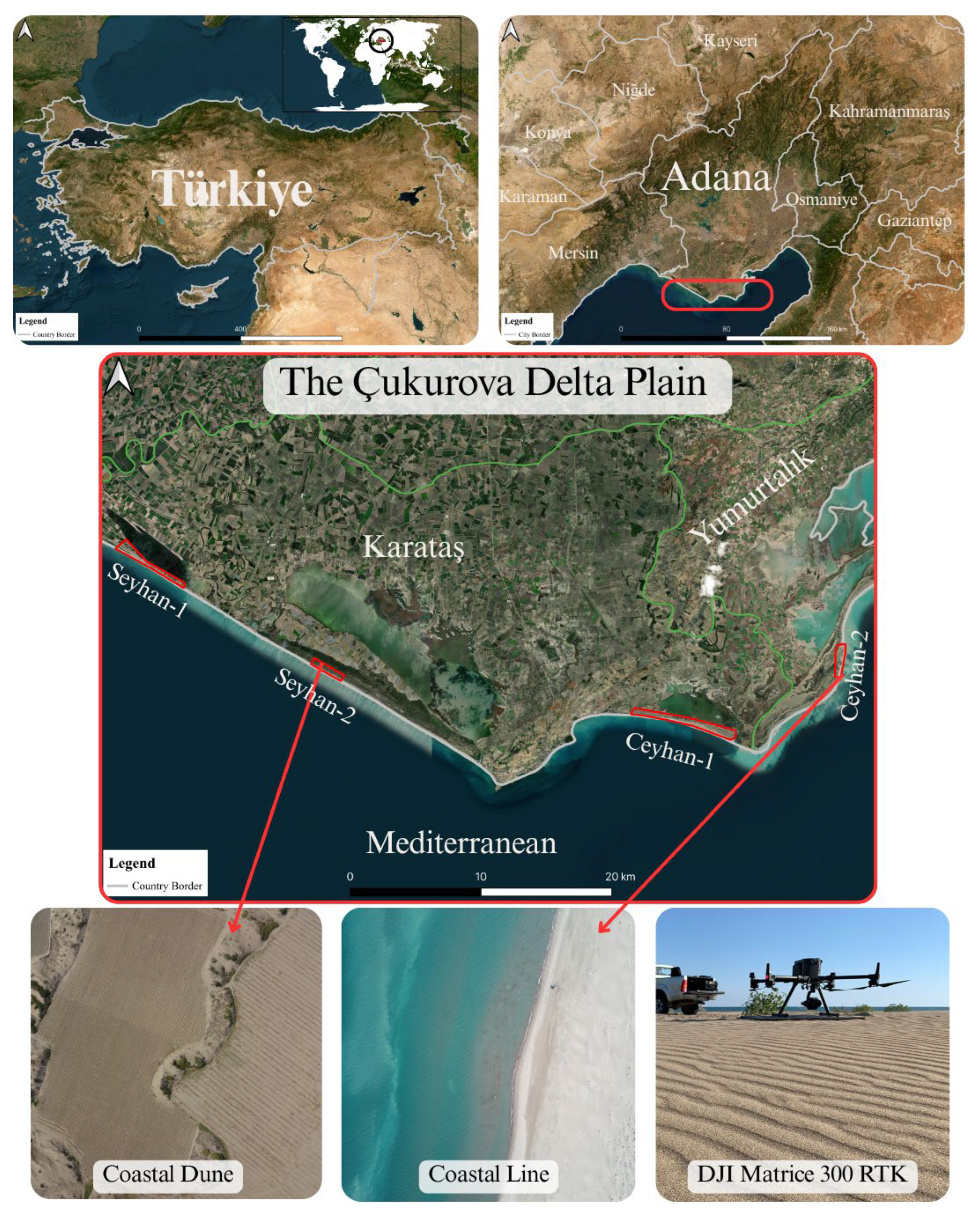
Figure 2.
An example of masking sea areas in UAV-based aerial photographs.
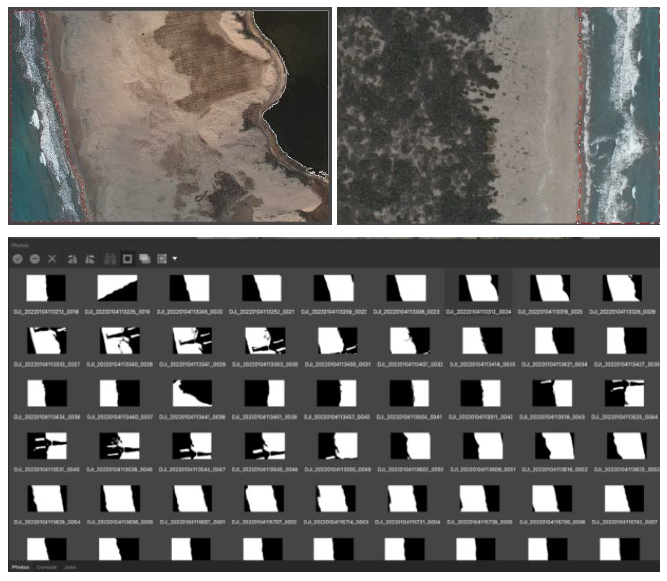
Figure 3.
Demonstration of (a) orthomosaic and (b) DSM for October 2020.
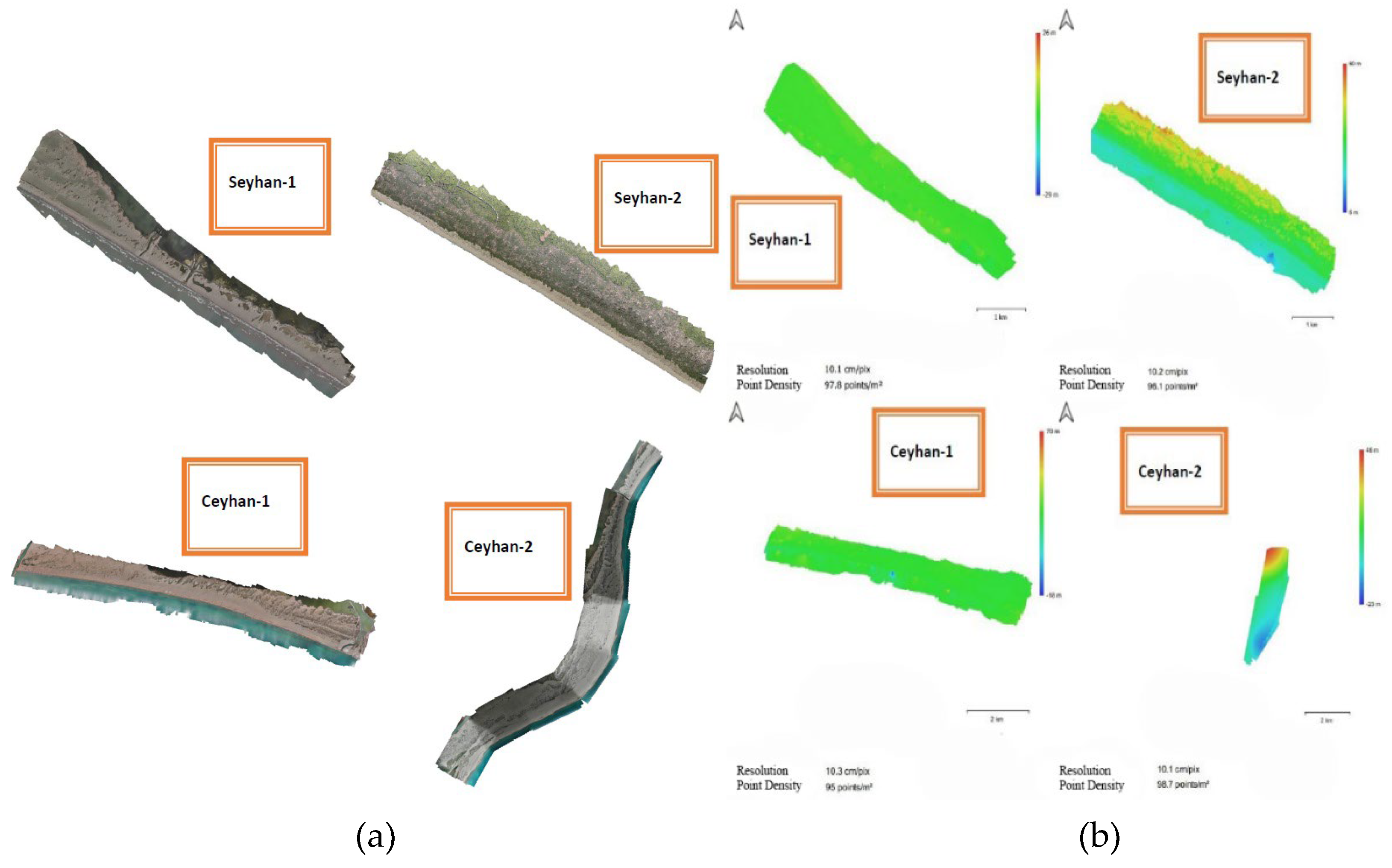
Figure 4.
Demonstration of DoD analysis between June 2021 and October 2020 in the Ceyhan-1 region.
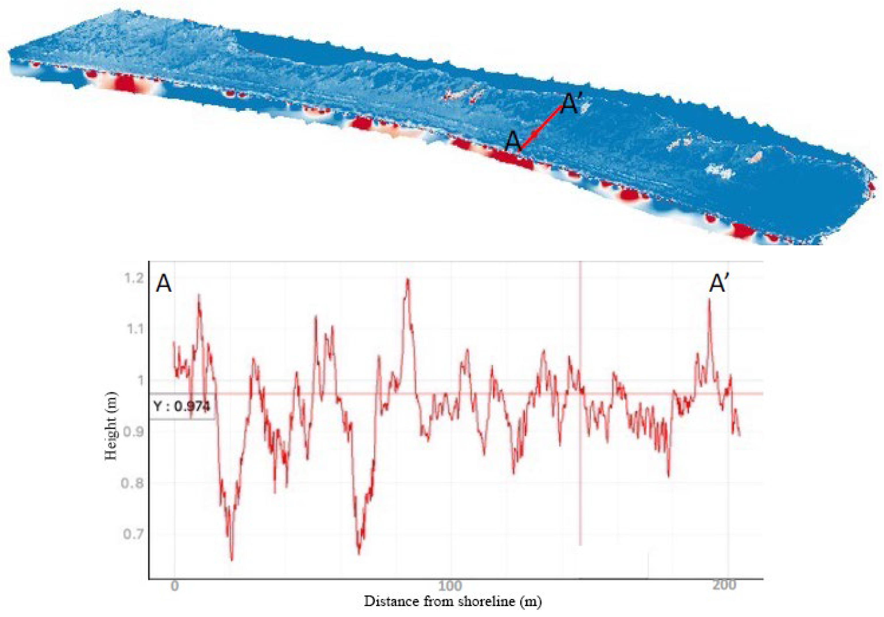
Figure 5.
The seasonal changes of the dunes between the years 2020 and 2021 in the Seyhan-1 region.
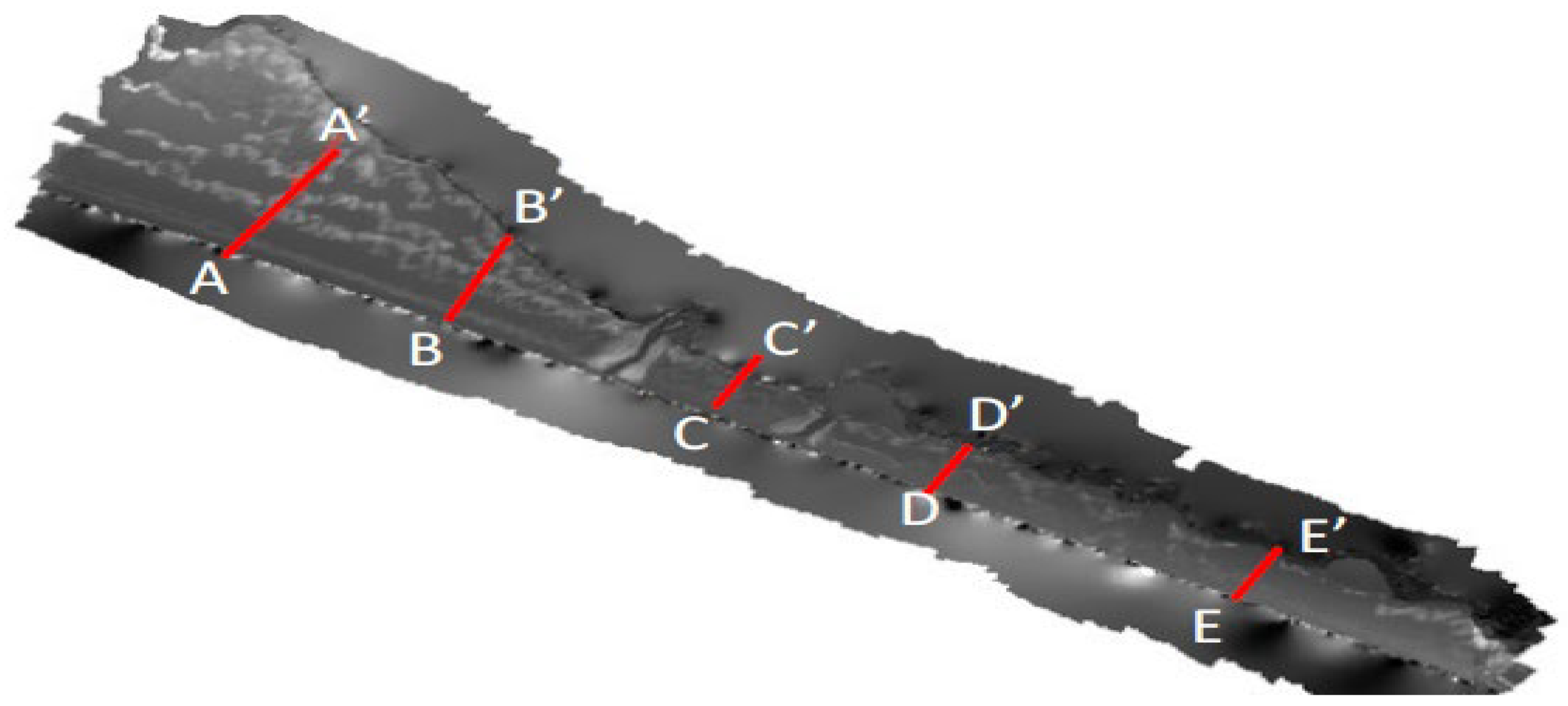
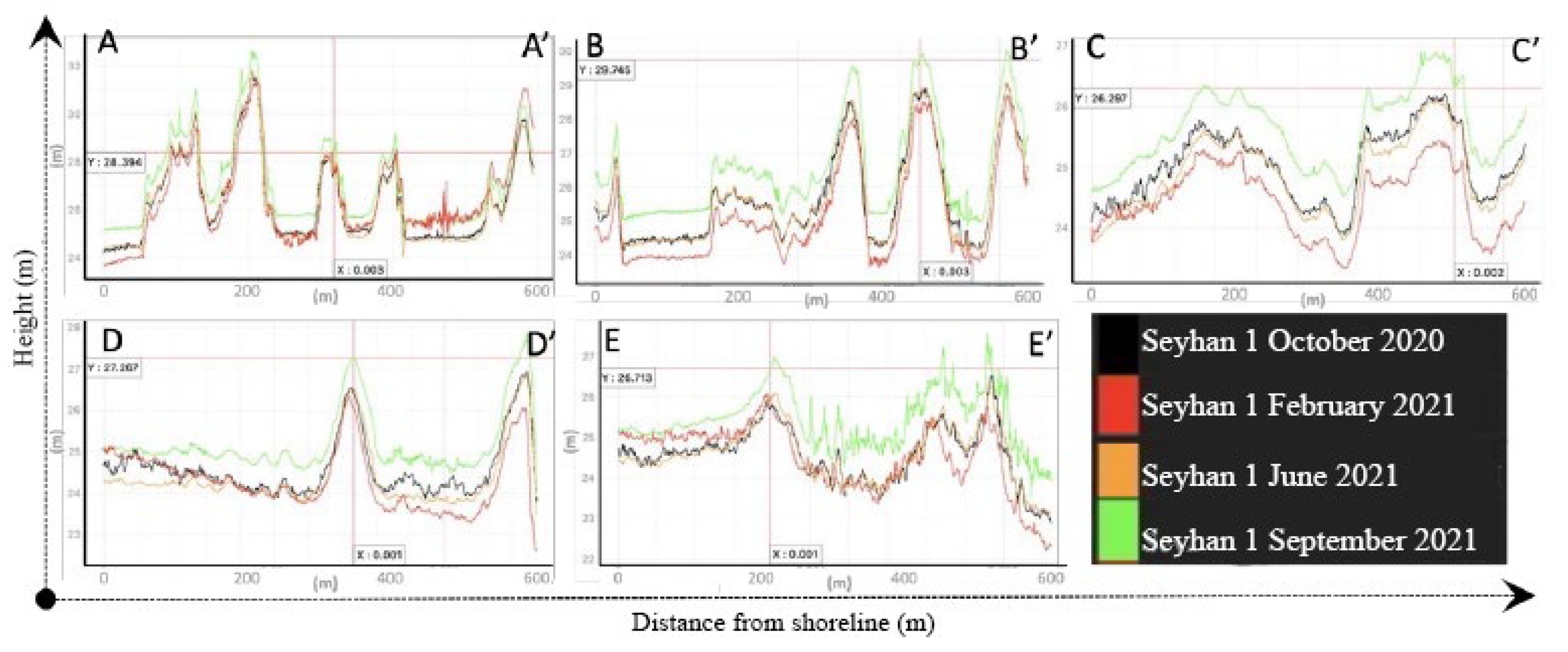
Figure 6.
The seasonal changes of the dunes between the years 2020 and 2021 in the Seyhan-2 region.
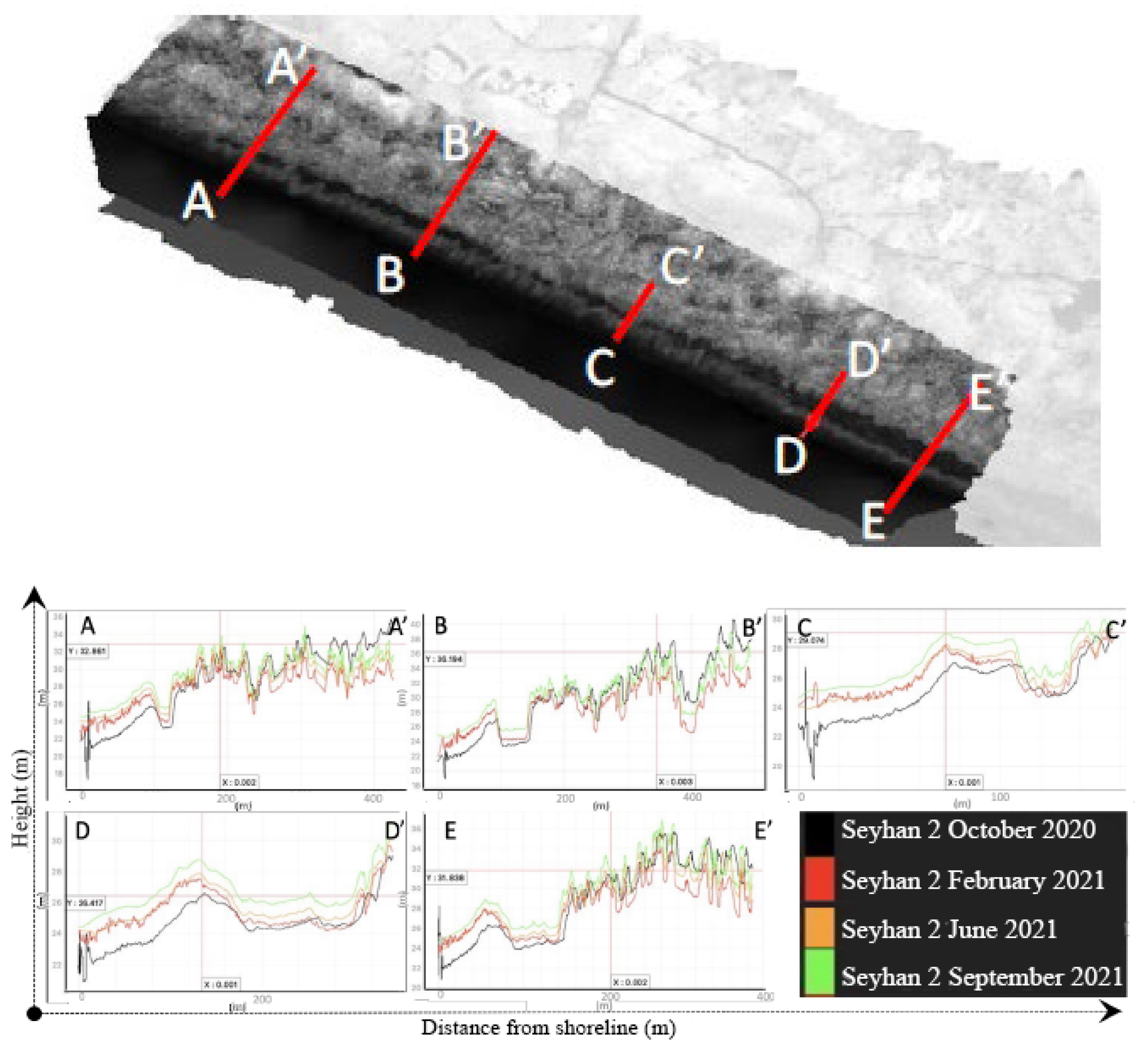
Figure 7.
The seasonal changes of the dunes between the years 2020 and 2021 in the Ceyhan-1 region.
Figure 8.
The seasonal changes of the dunes between the years 2020 and 2021 in the Ceyhan-2 region.
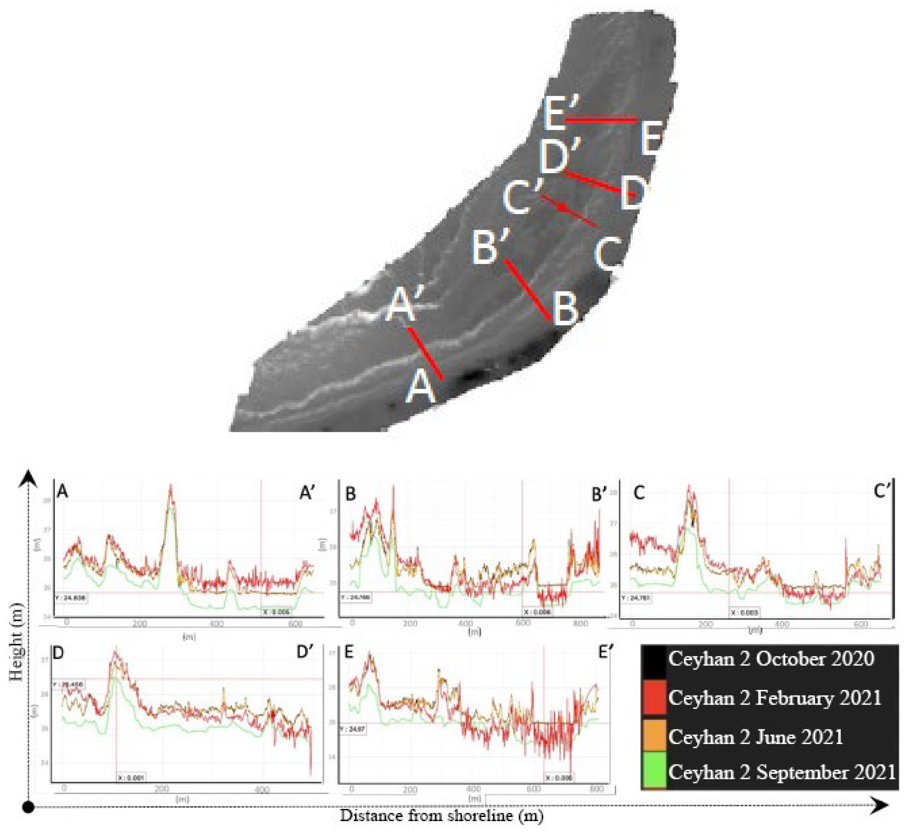
Figure 9.
Demonstration of dune movement and coastline change; a) Dune trap zones for dune detection project in the Ceyhan-1, b) afforested to restrict dune movement in Seyhan-2 based on the orthomosaics between the years 1950-2016.
Figure 9.
Demonstration of dune movement and coastline change; a) Dune trap zones for dune detection project in the Ceyhan-1, b) afforested to restrict dune movement in Seyhan-2 based on the orthomosaics between the years 1950-2016.
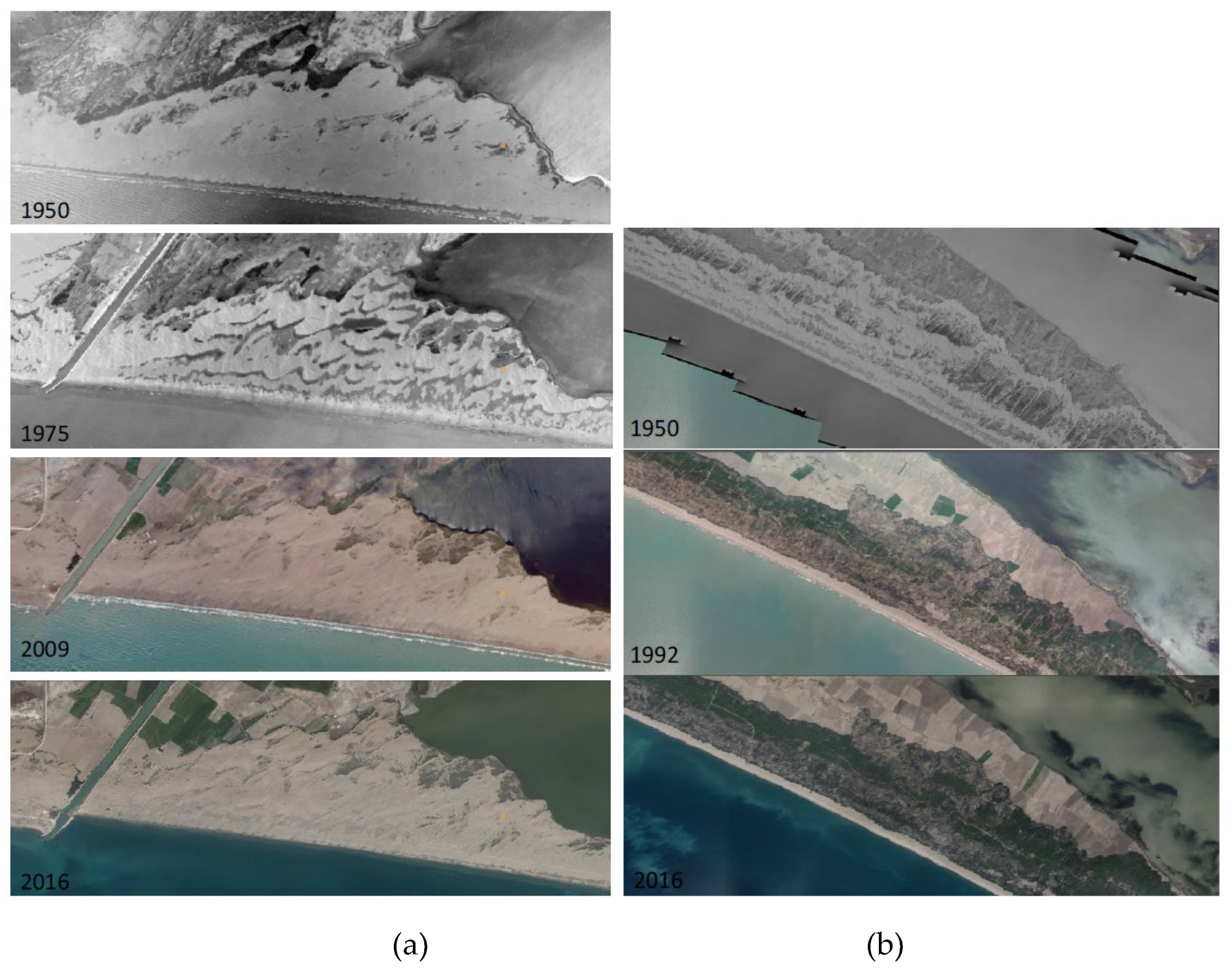
Figure 10.
Seyhan-1 sub-region; a) 2016-2009 b) 2009-1992 DoD analyses.
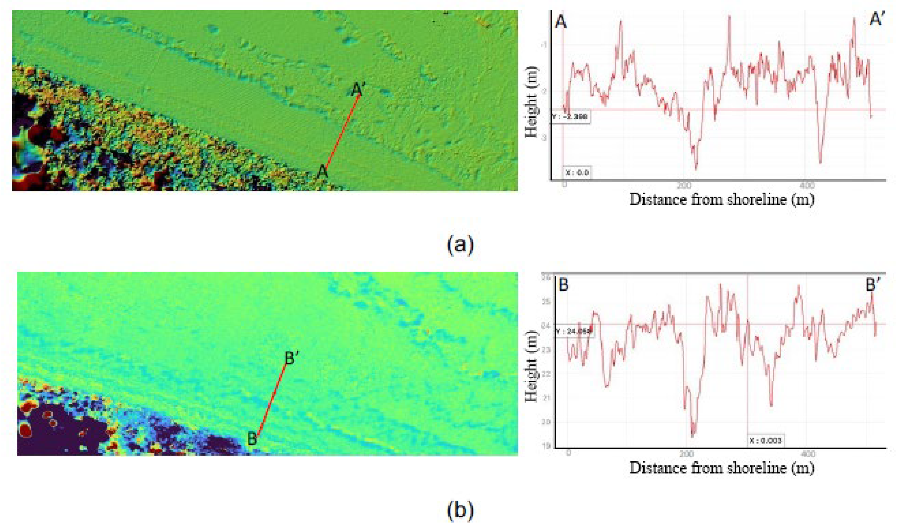
Figure 11.
Seyhan-2 sub-region; a) 2016-2009 b) 2009-1992 DoD analyses.
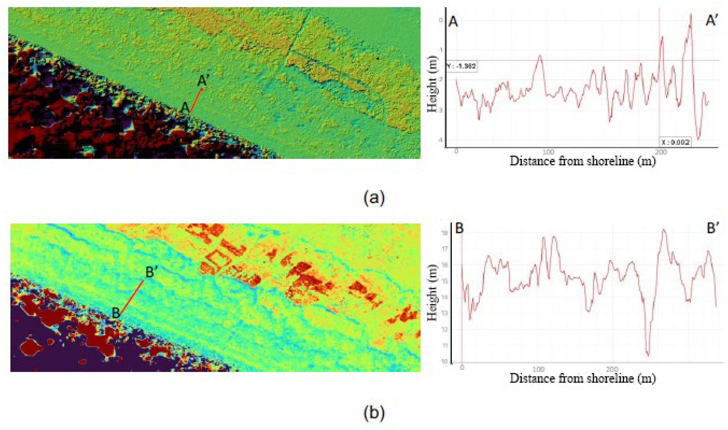
Figure 12.
Ceyhan-1 sub-region; a) 2016-2009 b) 2009-1992 DoD analyses.
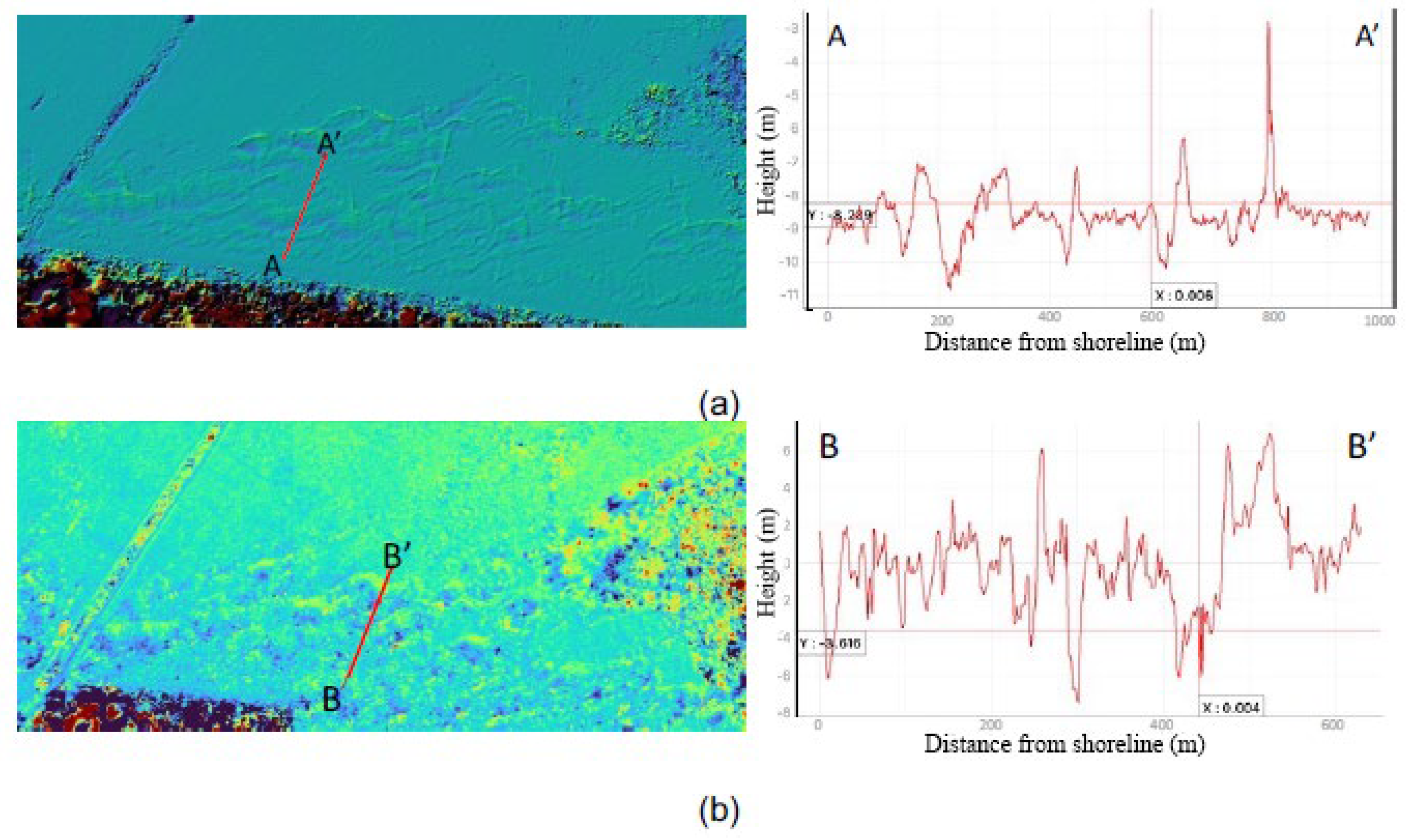
Figure 13.
Ceyhan-2 sub-region; a) 2016-2009 b) 2009-1992 DoD analyses.
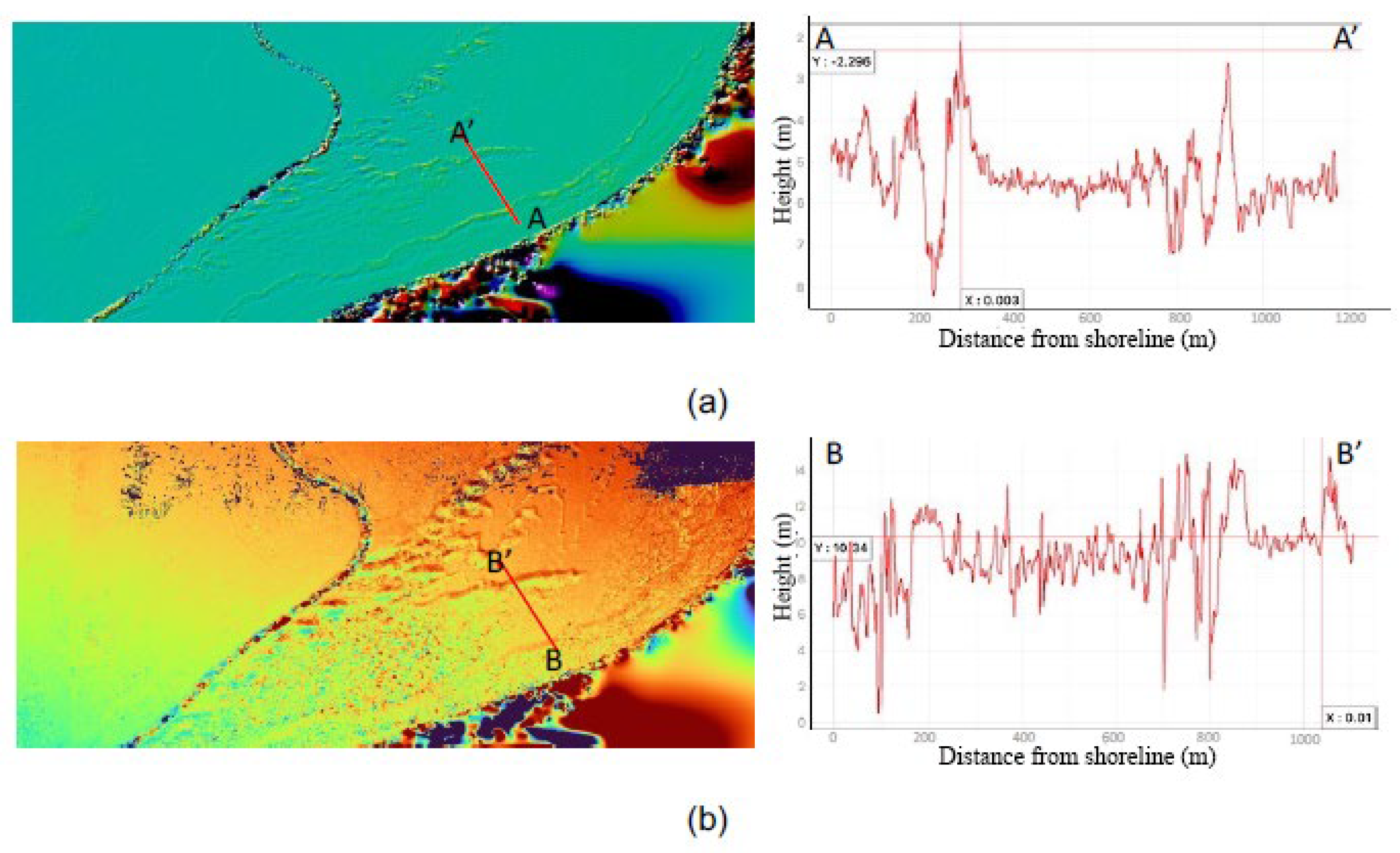
Figure 14.
A dune movement of 44 meters in the NE direction in the Ceyhan-1 region, with based on the analysis of the orthomosaics from the years 2009 to 2016.
Figure 14.
A dune movement of 44 meters in the NE direction in the Ceyhan-1 region, with based on the analysis of the orthomosaics from the years 2009 to 2016.
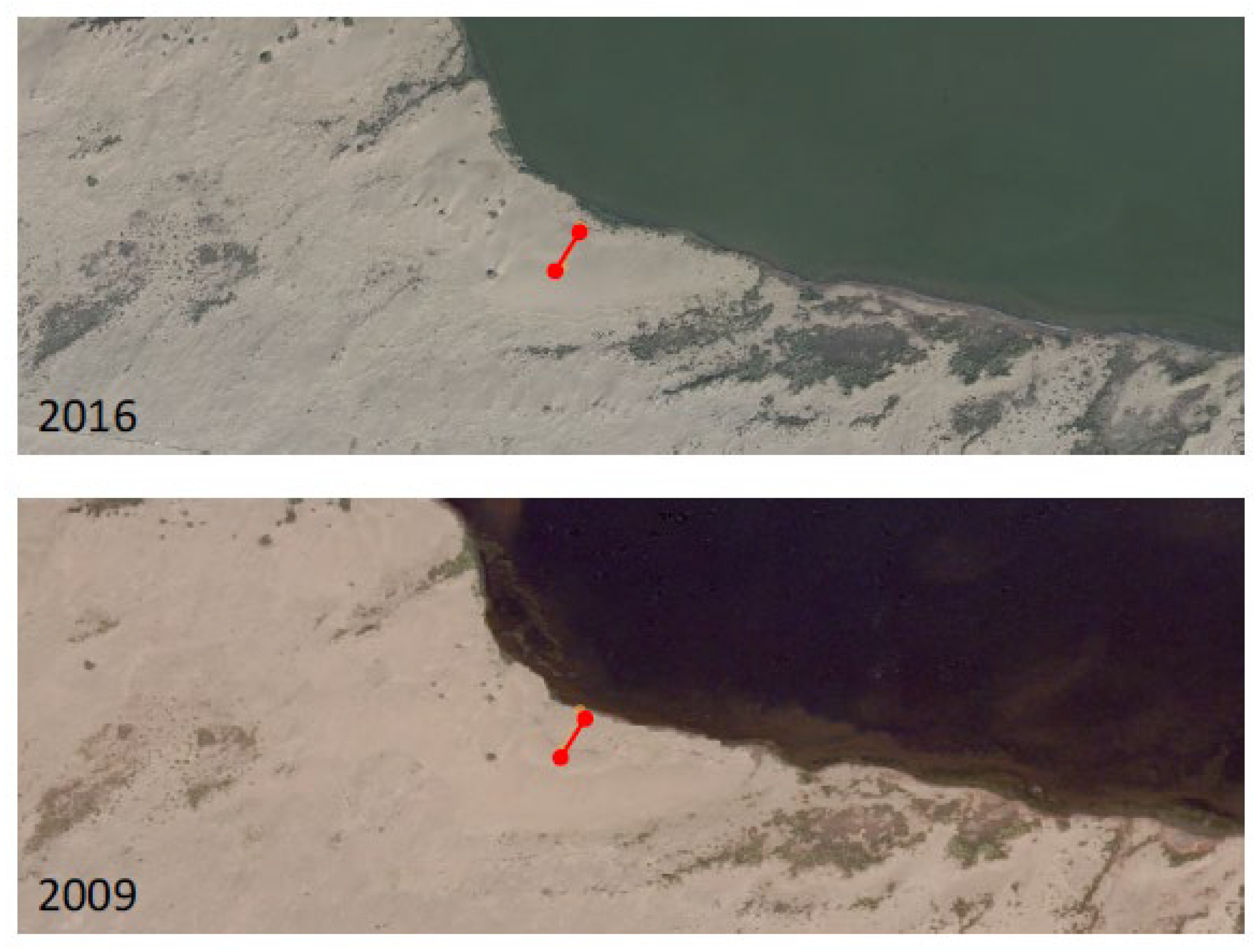
Figure 15.
A dune movement of 32 meters in the NW direction in the Ceyhan-2 region, with based on the analysis of the orthomosaics from the years 2009 to 2016.
Figure 15.
A dune movement of 32 meters in the NW direction in the Ceyhan-2 region, with based on the analysis of the orthomosaics from the years 2009 to 2016.
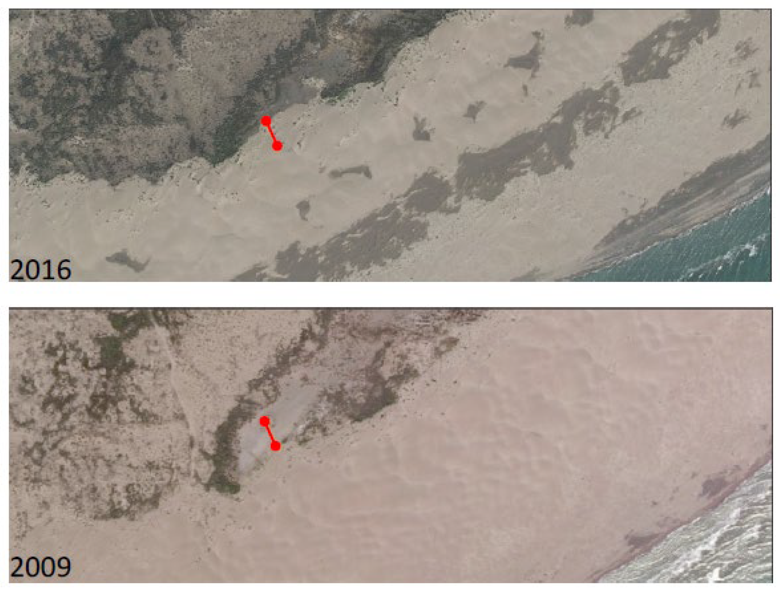
Figure 16.
A dune movement of 120 meters in the N direction in the Ceyhan-1 region, with based on the analysis of the orthomosaics from the years 1950 to 2009.
Figure 16.
A dune movement of 120 meters in the N direction in the Ceyhan-1 region, with based on the analysis of the orthomosaics from the years 1950 to 2009.
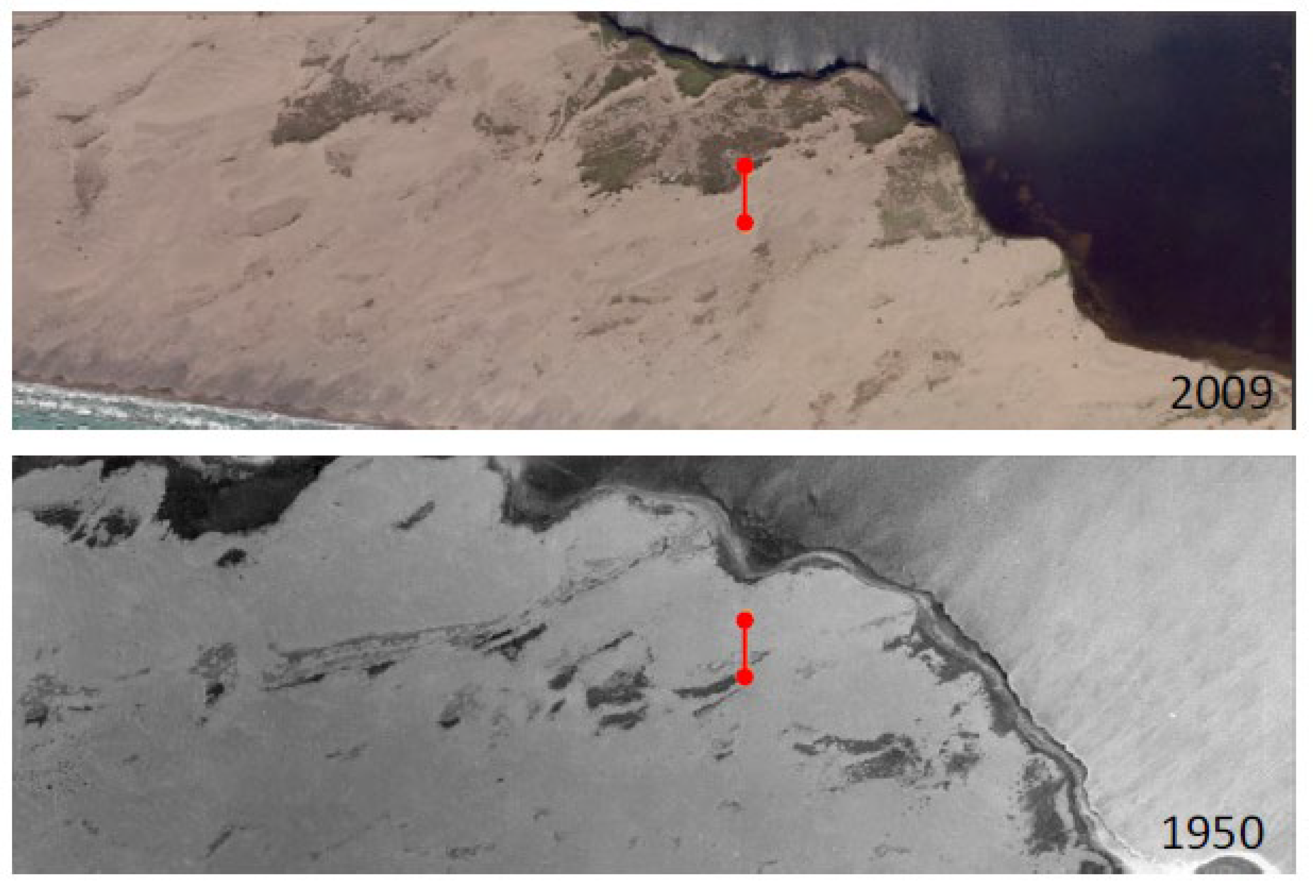
Figure 17.
A dune movement of 180 meters in the NE direction in the Ceyhan-2 region, with based on the analysis of the orthomosaics from the years 1950 to 2009.
Figure 17.
A dune movement of 180 meters in the NE direction in the Ceyhan-2 region, with based on the analysis of the orthomosaics from the years 1950 to 2009.
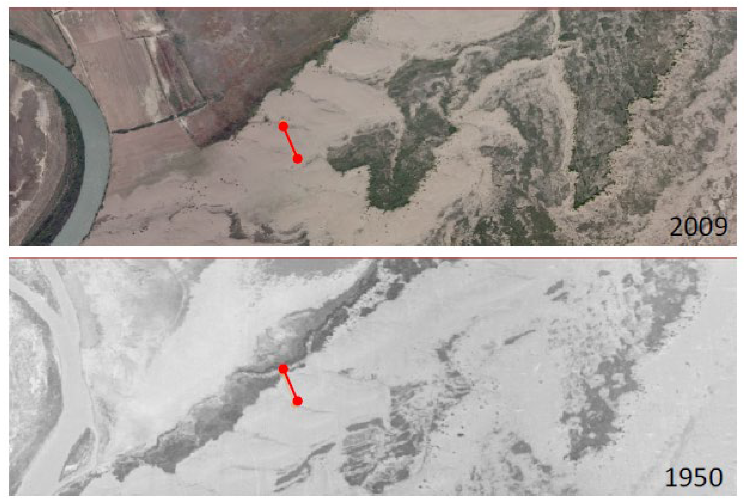

Table 1.
Number of photographs for the sub-regions.
| Sub-Region | October 2020 | February 2021 | June 2021 | September 2021 |
|---|---|---|---|---|
| Seyhan-1 | 504 | 503 | 613 | 454 |
| Seyhan-2 | 569 | 512 | 176 | 219 |
| Ceyhan-1 | 666 | 627 | 960 | 1087 |
| Ceyhan-2 | 1699 | 1076 | 679 | 679 |
Disclaimer/Publisher’s Note: The statements, opinions and data contained in all publications are solely those of the individual author(s) and contributor(s) and not of MDPI and/or the editor(s). MDPI and/or the editor(s) disclaim responsibility for any injury to people or property resulting from any ideas, methods, instructions or products referred to in the content. |
© 2025 by the authors. Licensee MDPI, Basel, Switzerland. This article is an open access article distributed under the terms and conditions of the Creative Commons Attribution (CC BY) license (http://creativecommons.org/licenses/by/4.0/).
Copyright: This open access article is published under a Creative Commons CC BY 4.0 license, which permit the free download, distribution, and reuse, provided that the author and preprint are cited in any reuse.


