
Submitted:
12 September 2025
Posted:
15 September 2025
You are already at the latest version
Abstract
The expansion of population and economic activities within urban settings has driven a surge in demand for diverse transportation modes leading to higher traffic volumes, increased probability of congestion due to spillback, and reduced Level of Service (LOS). To reduce that probability, studying signalized intersections is essential as they play a pivotal role in alleviating congestion by reducing delay, increasing traffic flow efficiency, and ensuring safety. This study investigates a congested intersection in Miami, Florida, USA, employing Highway Capacity Software (HCS) to evaluate operational performance. While geographically specific, the methodology is believed to be highly applicable to similar urban settings, where signalized intersections frequently face similar demand-supply mismatches. The analysis revealed severe delays, high queue spillbacks, and a LOS F during peak hours. Two data-driven scenarios were evaluated: (1) optimization of signal timing and (2) integration of a grade-separated pedestrian bridge with signal timing optimization. The combined implementation of the pedestrian bridge and optimized signal timing achieved nearly 53% reduction in delays and improved the intersection’s performance from LOS F to LOS E.
Keywords:
signalized intersections
; spillback
; level of service (LOS)
; Highway Capacity Software (HCS7)
; operational performance
1. Introduction
In a transportation network, intersections are a critical component, as they significantly influence the overall performance of traffic flow and capacity [1]. Although there are different types of intersections, including signalized and unsignalized, studying signalized intersections is particularly crucial due to the significant emphasis on regulating traffic flow, determining the Level of Service (LOS), optimizing network capacity, and mitigating congestion [2]. Ensuring efficient traffic flow and maintaining road safety involves drawbacks both for road users and society as a whole including operational and maintenance expenses, longer delays, and higher fuel consumption [3]. Furthermore, complex and unpredictable vehicle and pedestrian behaviors make it challenging to assess the LOS, thus, to effectively plan and increase efficiency, it is essential to understand the patterns and characteristics of both vehicle and pedestrian traffic [4]. Tools such as HCS, Synchro, CORSIM, SIDRA, SUMO, Vissim, and Aimsun enable detailed evaluations of intersection capacity and delay under various scenarios with visualization [5]. However, a research gap remains in literature regarding in-depth operational analyses and improvement strategies tailored to Florida’s unique urban traffic conditions. Florida’s subtropical climate, high tourist activity, and growing population contribute to distinctive traffic flow patterns and congestion issues that may not be addressed adequately by general traffic models or improvement strategies developed elsewhere. Furthermore, according to research by a specialized company, Miami is ranked 9th with the worst traffic globally and 5th in the USA [6]. Additionally, the lack of context-sensitive research highlights the need for a data-driven framework that evaluates improvement strategies while assessing their applicability to intersections that deal with heavy traffic flow from a global perspective. Thus, this study aims to bridge that gap by presenting a detailed operational analysis of a signalized intersection in Miami and evaluating the effectiveness of targeted capacity improvement strategies.
The findings aim to inform local traffic management strategies and guide future studies in similar urban settings facing congestion and having poorer LOS. The primary objective of this project is to assess the intersection’s operational performance during the PM peak-15-minute period and propose signal timing improvements to mitigate spillbacks, particularly in the context of the 95th percentile queue storage ratio. The analysis was conducted using Highway Capacity Software 7 (HCS7), a widely used tool for evaluating the performance of signalized intersections that incorporate various modules and submodules based on the procedures and methodologies outlined in the Highway Capacity Manual (HCM) with basic parameters and inputs [7]. The selected intersection is controlled by traffic signal and supports multiple traffic movements, including left-turn, through, right turn, along with pedestrian crossings, all of which impact regular traffic flow. The study evaluates the existing traffic flow based on a three-day average of vehicle and pedestrian counts during the PM peak (5:15 PM to 5:30 PM). Traffic conditions, including vehicle types (with 3% heavy vehicles) and arrival types (Arrival Type 4 for East-West through movements and Arrival Type 3 for other movements), are considered to simulate realistic traffic behavior. This research provides an in-depth assessment of the intersection’s capacity and proposes signal timing adjustments that could improve its performance by reducing spillbacks and improving overall traffic flow, which can be adopted anywhere with a similar context.
The main goal of this research is to improve the operational performance of a congested signalized intersection. To achieve this goal, three key objectives have been defined. First, to assess the existing traffic conditions at the intersection by analyzing the traffic flow during the PM peak period, evaluating traffic volume and signal timings, and determining the Queue Storage Ratio (RQ) for all movements to identify areas of spillbacks using HCS7. Second, to identify spillbacks for critical movements, including left-turn, through, and right-turn movements, by utilizing the 95th percentile. Third, propose improvements to signal timings, considering pedestrian-related delays based on the spillback analysis, aiming to reduce the RQ and enhance intersection performance.
Study Area Profile
In recent decades, significant amount of research has been conducted to evaluate the operational and safety performances of signalized intersections and roundabouts in various countries [8]. Research on signalized intersections has focused on several factors such as delay time, signal duration, and traffic management systems, demonstrating improvements in traffic flow, delays, safety, and environmental impacts. This emphasizes the need to optimize four-legged intersections [9]. Considering the parameters that affect the operational performance, this study presents a detailed capacity analysis of the intersection at SW 109th Avenue and SW 8th Street in Miami, Florida, USA, near the Modesto main campus of Florida International University. experiences high traffic volumes and regular peak-hour congestion. Its geometry consists of several through lanes, dedicated left-turn and right-turn lanes, and standard signal phases. Traffic counts, signal timings, and geometric information were gathered through field surveys and secondary data sources. The satellite image of the intersection is shown in Figure 1.
2. Materials and Methods
The proposed methodology is divided into four stages to improve persisting traffic conditions. Comprehensive traffic data regarding geometry, signal timing, and traffic volume is an essential part of any traffic analysis for making informed decisions [10]. The data used to analyze the intersection has been obtained from multiple platforms and resources. These data sets have been utilized to provide input parameters to evaluate the intersection’s capacity and create improvement scenarios for analysis with HCS7. HCS7 is a widely recognized and comprehensive traffic analysis tool that incorporates all the required modules based on the procedures and methods outlined in the HCM (7th edition). Considering the basic parameters and inputs, this tool has the ability to quickly and efficiently analyze traffic operation, optimize the signalized intersection performance by reducing delays and queue lengths by adjusting in-cycle times [7]. Figure 2 illustrates the proposed research methodology to improve the LOS and reduce traffic delays of the intersection.
2.1. Traffic Volume
The geometric conditions of the intersection have been obtained from Google Maps and field surveys and are shown in Figure 1. This geometric data has been crucial for understanding the intersection’s capacity and performance. The following key parameters have been considered. The storage lengths (in ft.) for all left-turn lanes, through lanes, and right-turn lanes, and the average width of each lane (in ft.) in the Eastbound (EB), Westbound (WB), Northbound (NB), and Southbound (SB) directions have been measured and summarized in Table 1.
Traffic volume data was based on three-day average counts for vehicles and pedestrians during the PM peak of the 15 minutes. The peak period specifically considered is between 5:15 PM and 5:30 PM. To convert the 15-minute interval counts into vehicles per hour (veh/h), the raw data has been multiplied by a factor of 4. The resulting flow rates for each movement are detailed in Table 2 below. The data breakdown includes volumes for EB, WB, NB, and SB directions, with specific counts for left-turn, through, and right-turn movements and pedestrian crossing data.
2.2. Signal Timing
Managing signalized intersections involves determining the number and timing of traffic signal phases to ensure smooth traffic flow and reduce congestion [11]. The selected intersection uses pre-timed signal control which includes an overlap right-turn phase for NB and SB right-turn movements. This overlap phase allows simultaneous right turns while conflicting directions receive red signals, optimizing the flow of right-turning traffic. Signal timing data was sourced from the Miami-Dade County Traffic Signal Documents and captured on 4 October 2021 [12]. Figure 3 shows the overlap right-turn phase condition in the intersection. The signal phases include key parameters such as Maximum Green, Yellow (Y) Change, and Red (R) Clearance times. The specifics of these times have been used to model the current intersection capacity and congestion. During the PM peak period, the intersection has been operated with a cycle length of 190 seconds under Plan 12, specifically designed to accommodate the high traffic volumes observed between 5:15 PM and 5:30 PM. The cycle timings have been highlighted with a red border in Table 3 and Table 4 respectively.
2.3. Considerations
Field survey data included a 3% heavy vehicle percentage for traffic flow and the application of Arrival Type 4 for east-west through movements, with Arrival Type 3 used for other movements. Arrival Type 3 is typically employed when signal coordination is absent, or vehicle arrivals are random due to dispersed platoons. Arrival Type 4 represents moderately dense platoons arriving during the middle of the green interval or dispersed platoons with 40%-80% of the group volume arriving throughout the green. A 25-foot corner radius and 40-foot detector length were used for all approaches. The saturation flow rate is set at 1900 passenger cars per hour per lane, and pre-timed signal control is used. Buses were excluded from the analysis, as bus frequency was approximately one every 1.5 hours. The peak hour factor (PHF) was calculated as per HCM [2] and found to be 1.0. The posted speed limit was 40 mi/h, a minimum green time of 6 seconds was applied to all phases, and the intersection grade was 0%. Table 5 provides an indication of the quality of progression associated with selected platoon ratio values.
2.4. Analysis Framework
The operational analysis of the intersection has been conducted using HCS7, following the methodology outlined in the HCM (7th Edition) [13]. Initially, the existing condition of the intersection has been modelled to establish a baseline, providing a comprehensive understanding of its operational performance during peak hour traffic. Following this, two alternatives have been explored to assess their potential impact on intersection efficiency and congestion reduction. These improvements include signal timing optimization, which involve adjusting green signal period and cycle lengths to improve the distribution of green time and minimize delays. Further, phase sequence modifications have been tested to reduce conflict between opposing traffic movements, enhancing safety and traffic flow. However, inclusion of separate elevated pedestrian crossing bridge has been proposed to mitigate pedestrian-related delays and minimize interruptions to vehicular traffic. Each improvement scenario has been rigorously compared to the baseline conditions to quantify the resulting benefits, focusing on key performance indicators such as delay reduction, LOS improvement, and overall enhancement of traffic flow. This data-driven approach has allowed to identify the most effective strategies for mitigating conges gestion and improving intersection operation. The LOS values used in this study have obtained from Exhibit 19-8 of the Highway Capacity Manual (HCM, 7th Edition) [13], as shown in Table 6.
3. Results
3.1. Baseline Performance
Demand information and signal timing were input into HCS7 to evaluate the existing performance. The baseline analysis highlighted significant operational inefficiencies at the signalized intersection. The Queue Storage Ratio (RQ) exceeded critical thresholds for multiple movements, with the SB Right Turn exhibiting an RQ of 11.13 and the Northbound Through (NBT) and Northbound Right (NBR) movements having RQ values of 3.56 and 5.94, respectively. These elevated RQ values point to severe queue spillbacks, particularly in the SB and NB directions. The intersection operates at LOS F, with a total intersection delay of 167 seconds per vehicle, demonstrating the magnitude of congestion and delay during peak traffic periods. The NB approach experienced the highest delay (630.7 seconds per vehicle), reinforcing the substantial operational inefficiencies. Figure 4 and Figure 5 illustrate the input and results of the baseline operational performance respectively.
3.2. Scenario 1: Signal Timing Optimization
To improve the baseline operational performance of the intersection, signal timing was optimized by adjusting green time allocation, cycle length, and phase sequencing. These changes led to a significant reduction in RQ values across most movements. The NBT RQ improved from 3.56 to 1.31, a 63.5% reduction. Similarly, the SBR RQ decreased from 11.13 to 5.44, a 51.12% reduction. Consequently, the overall delay decreased to 81.8 seconds per vehicle, a 51.02% improvement. Although the overall LOS remained F, individual approach delays improved significantly. NB and SB delays reduced to 60.1 and 74 seconds per vehicle, respectively, highlighting the operational improvement from the signal timing changes as shown in Figure A1 and Figure A2. Table 7 shows the comparison between both scenario and Figure 6 illustrates the changes in percentage of Maximum green time.
As shown in Figure 6, green time was redistributed by substantially cutting allocations for the east–west through phases—roughly 71% for EBT and 65% for WBT. The time saved from these movements was reassigned to approaches under heavier demand, most notably EBL, which more than doubled its allocation, and NBT, which received nearly three times its original share. By shifting capacity to the most constrained approaches, the revised timing plan helped relieve congestion and played a key role in improving overall intersection performance, although the overall LOS remained at F.
3.3. Scenario 2: Signal Timing with Elimination of Pedestrian Signal
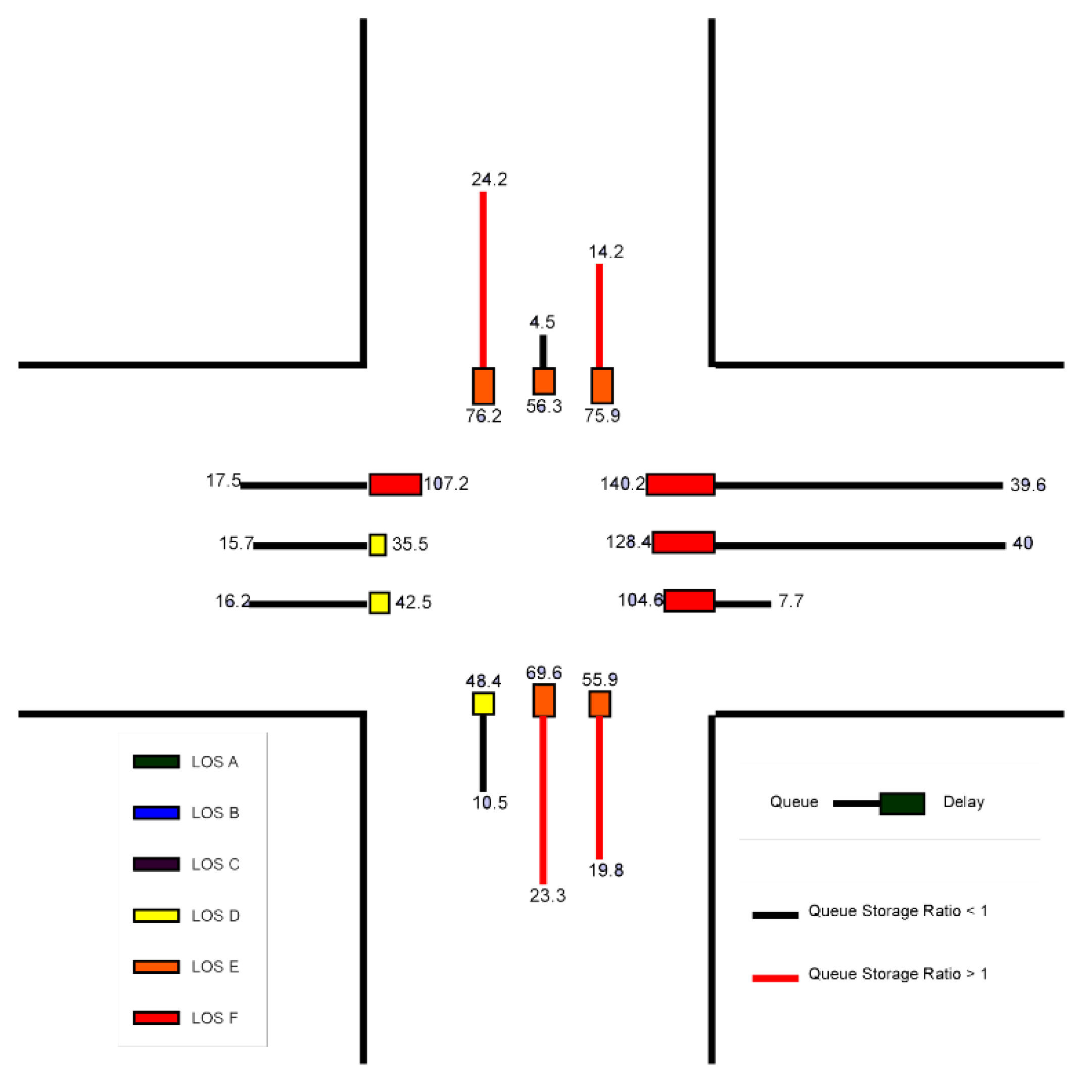
The second scenario proposed eliminating pedestrian signal phases by constructing a grade-separated pedestrian bridge, combined with signal timing changes. The SBR RQ decreased to 5.12, representing a 54% reduction from the baseline. Overall delay dropped to 78.5 seconds per vehicle, a 52.99% improvement over the baseline. Consequently, the LOS improved from F to E, reflecting a significant increase in operational efficiency. Furthermore, approach delays continued to decline, reaching 59.2 seconds per vehicle (NB) and 68.6 seconds per vehicle (SB). Eliminating pedestrian signal delays combined with optimized signal timing had a positive, cumulative effect on traffic flow and overall performance of the intersection. The changes in parameters regarding signal timing and the outputs have been demonstrated in Figure A3 and Figure A4.
3.4. Comprehensice Performance Comparison
To provide a comprehensive comparison of operational outcomes, Figure 7 emphasized four key performance metrics across the baseline, Scenario 1, and Scenario 2. Figure 7a showed clear reductions in Queue Storage Ratio (RQ) for all movements, with the most notable improvements in the NBT and SBT movements, each reducing more than half of their baseline values. Figure 7b illustrated consistent LOS upgrades from F to D/E
in most approaches, with Scenario 2 achieving significant improvements. Figure 7c highlighted the downward trend in intersection delay, dropping by over 50% from the baseline in Scenario 1 and slightly further in Scenario 2. Furthermore, Figure 7d confirms substantial approach delay reductions, exceeding 90% for the Northbound approach and around 75% for the Southbound approach. Collectively, these results indicated that while Scenario 1 delivered overall operational efficiency, Scenario 2 provided additional performance benefits alongside improved safety eliminating the probability of pedestrian–vehicle conflicts.
4. Discussion
Conventional four-legged intersections, while common, are often inefficient due to heavy traffic movements and highly susceptible to congestion issues [14]. This study examined the operational performance of the conventional four-legged signalized intersection focusing on LOS and RQ improvements using HCS7, proposing two scenarios to increase efficiency. The best alternative, which incorporated signal time optimization and a grade-separated pedestrian bridge, showed a 53% reduction in delays, resulting in LOS E from F. While HCS7 provides a standardized assessment, tools like Vissim could capture more detailed lane-level interactions. Using the Surrogate Safety Assessment Model (SSAM), Mohamed et al. [15] evaluated a Displaced Left-Turn (DLT) intersection using Vissim reducing average delay over 48% with corresponding improvements in capacity and fuel consumption under both balanced and unbalanced traffic conditions. In comparison, without geometric reconfiguration, improvement scenario 1 resulted in a 51.02% reduction in average delays with substantial improvement in RQ – for instance, NBT movements improve from 3.56 to 1.31. Although the delay and queue length decreased, the LOS remained F in the HCS7 framework. These improvements have wider implications for urban mobility: reduced delays can lead to less vehicle idle time, lower fuel use, and decreased greenhouse gas emissions, as supported by the findings in [14,16]. However, in case of improvement scenario 2 the study has eliminated pedestrian signal phase by proposing a grade-separated crossing. As a result, the average delay dropped further to 78.5 s/veh, and the LOS improved from F to E. Arshi et al. [16], using a custom HCM-based model, assessed the performance of two-way stop control (TWSC), roundabouts and signalized intersections. They suggested that eliminating pedestrian delays yields significant operational gains across all control types as the intersections become increasingly inefficient as pedestrian demand rises. Similarly, implementing a grade-separated crossing in this study significantly improved performance. In addition, [17] suggested to follow the designs that mitigate crash risk for vulnerable road users, which recommended to remove pedestrian-vehicle conflict points according to their guidelines. The guidelines further recognized grade-separated crossings such as pedestrian overpass as effective countermeasures in high volume traffic areas, offering greater safety and maintainability. Similar safety measures were noted by Turner et al. [18], where grade separation at high volume intersections significantly reduced pedestrian crash exposure and enhanced flow efficiency. In both improvement scenarios of this research, signal optimization has been conducted. HCS7 based analysis achieved RQ reduction over 50% and improved LOS without any geometric change of intersection, for example, SBR RQ dropped from 11.13 in the baseline to 5.12 which demonstrates significant capacity gains with its deterministic framework. Bai et al. [19], using a custom framework signal optimization modeling for Signalized Turbo Roundabouts (STRAB). Results showed that STRABs outperform the conventional signalized intersections under high right-turn demand and saturated flow. Allowing detailed changes and performing twice-stop-right-turn (TSRT) control, it has minimized internal weaving. Thus, their customized framework and modeling approach have allowed adaptive phasing, complex geometry, and spiral lane transitions, whereas in HCS7, these features are not supported.
5. Limitations and Scope
This analysis was conducted using the HCS7 framework, which follows the deterministic methodologies of the Highway Capacity Manual. On the positive side, several studies have shown that HCS can produce delay estimates with very low average error margins (≈1.9%) and high coefficients of determination (R² ≈ 0.99), making it a reliable tool for preliminary planning and policy assessments [20]. Such consistency emphasizes its value as a benchmark framework in capacity and delay evaluation. However, field studies have shown that HCS often overestimates control delay, especially at higher congestion levels, where its interpretation differs from observed conditions [21]. By contrast, tools like SIDRA and Synchro have demonstrated closer agreement with field conditions under certain ranges, though they may introduce larger deviations when compared directly with HCM benchmarks [20,21]. Moreover, microsimulation-based models such as Vissim reveal additional weaknesses in deterministic approaches like HCS, as they cannot fully account for dynamic driver behavior, stochastic arrival patterns, queue spillback, or midblock interactions. Studies comparing HCS with Vissim reported deviations of up to 20–35% in critical indicators such as delay and flow density in some cases [22], suggesting that small changes in traffic demand may produce disproportionately higher delays in real-world conditions than HCS predicts. Although deterministic approach of HCS limits its ability to represent the variability and complexity of observed traffic conditions. More detailed design and safety assessment therefore require support from calibrated models. Tools like Vissim, SIDRA, and other custom models provide dynamic and stochastic capabilities, but HCS7 remains a reliable and standardized option for early diagnostics, and policy decisions, particularly in settings with limited data or simulation expertise. Future research should focus on dynamic simulation tools which considers vehicle–pedestrian interactions, lane use patterns, and adaptive phasing. Applying models such as SSAM would also enable a quantitative assessment of conflict frequency and severity, offering a stronger basis for safety evaluation. Incorporating environmental impact assessment and cost–benefit analysis of alternative scenarios derived from the software outcomes would provide stronger evidence to support decision-making and policy development.
6. Conclusions
This study evaluated the performance of one of the congested four-legged signalized intersections of Miami comparing baseline conditions and two improvement scenarios using HCS7. In Scenario 1, signal optimization alone reduced delays and RQ values, though the overall LOS remained at F. In contrast, Scenario 2, which combined optimized timing with the elimination of pedestrian phases through a grade-separated crossing, offered the best alternative, cutting delays by more than 50% and upgrading the overall LOS from F to E. Improving efficiency with both alternatives, proposal of pedestrian bridge further enhanced safety by eliminating vehicle-pedestrian conflicts offering broader societal benefits through potential reductions in fuel use, emissions, and crash risks. Consequently, while HCS7 offered a practical and standardized framework for assessing congested intersections, its deterministic approach limits how well it reflects the dynamic nature of real traffic, pointing to the need for future studies that employ advanced microsimulation tools and integrated safety evaluations. In conclusion, the results indicated targeted operational strategies, specifically signal optimization combined with pedestrian grade separation which represented a practical approach for improving performance at congested intersections where geometric expansion was not a viable option.
Supplementary Materials
The following supporting information can be downloaded at the website of this paper posted on Preprints.org.
Author Contributions
Conceptualization, D.P.; Methodology, M.A. and D.P.; Software, M.A. and D.P.; Validation, M.A., D.P, A.A. and J.A.; Formal analysis, M.A. and D.P.; Resources, M.A and D.P.; Data curation, M.A. and D.P.; Writing—original draft preparation, M.A. and D.P.; Writing—review and editing, M.A., D.P. and A.A.; Visualization, M.A. and D.P.; Supervision, A.A., J.A. and M.A.; Project administration, A.A., J.A., and M.A.; Funding acquisition: A.A., J.A., and M.A. All authors have read and agreed to the published version of the manuscript.
Funding
This research received no external funding.
Institutional Review Board Statement
Not applicable.
Informed Consent Statement
Not applicable.
Acknowledgments
The authors acknowledge Miami-Dade County Traffic Signal Documents for access to vital signal timing and coordination data. This information was instrumental in conducting the intersection’s operational analysis. Further, appreciation is also extended to all individuals and institutions whose support and resources contributed to the successful completion of this research.
Conflicts of Interest
The authors declare no conflict of interest.
Appendix A
Figure A1.
Data Input and Configuration in HCS7 Software for Improvement Scenario 1.
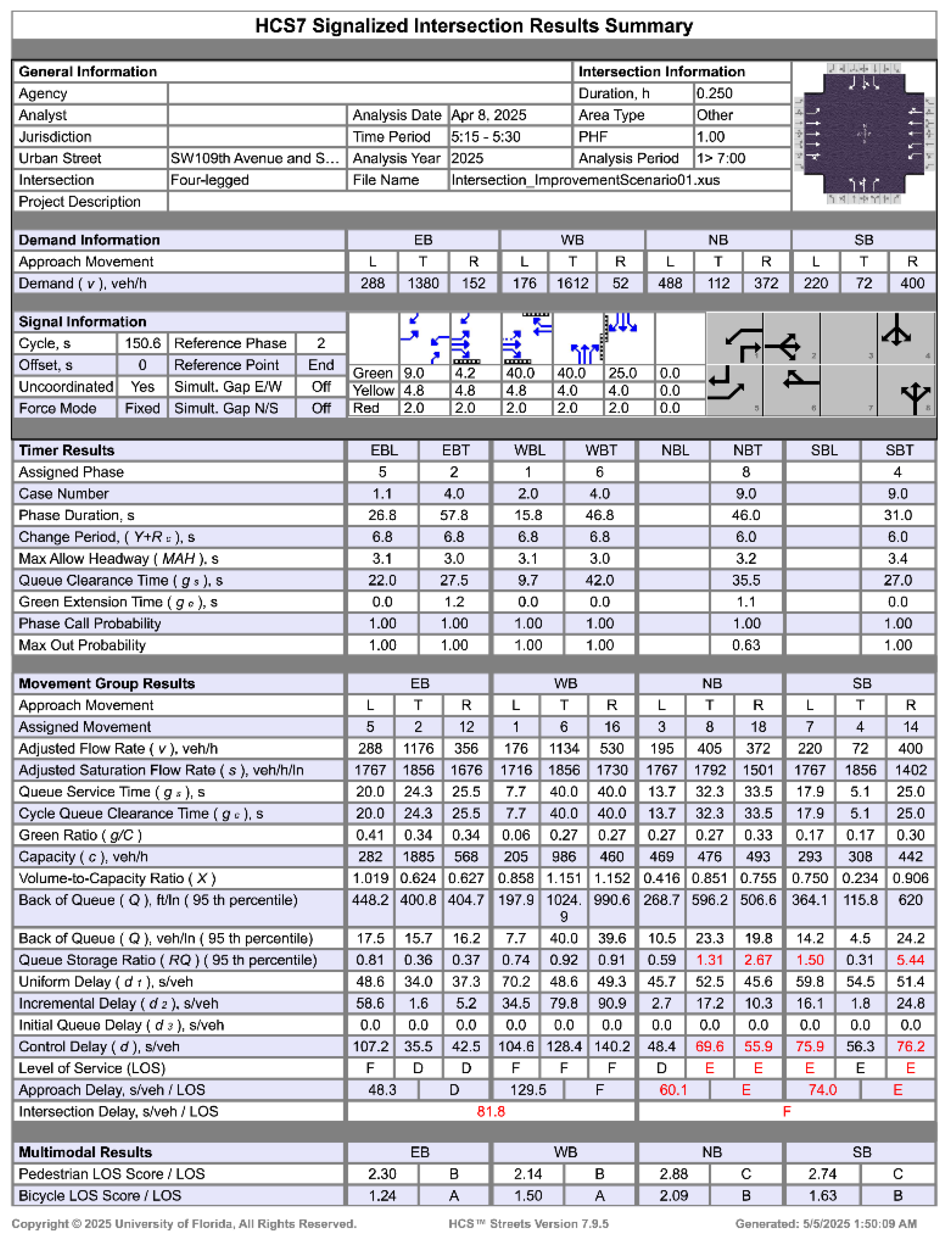
Figure A2.
Results of the Intersection from Improvement Scenario 1.
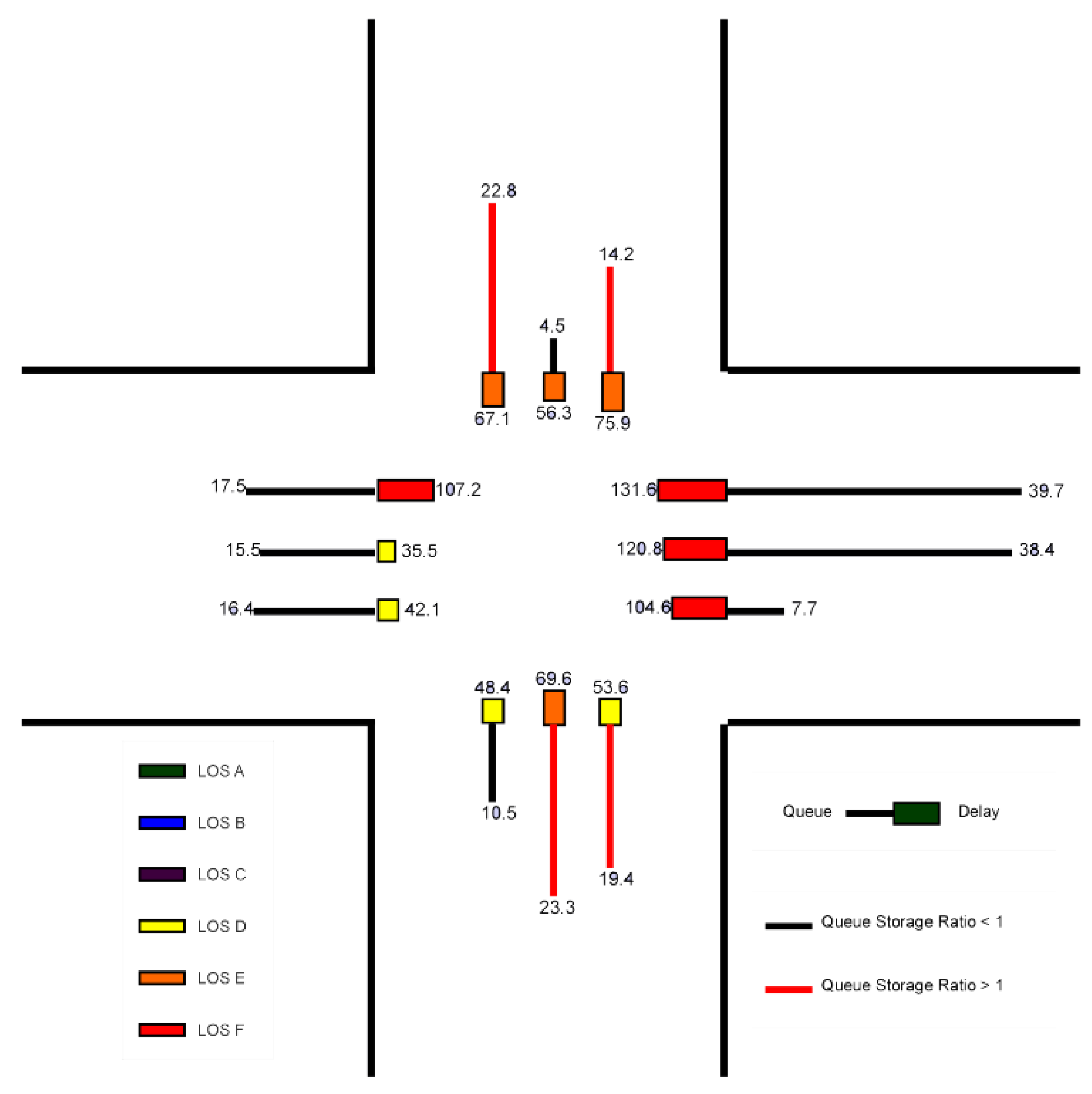
Figure A3.
Data Input and Configuration in HCS7 Software for Improvement Scenario 2.
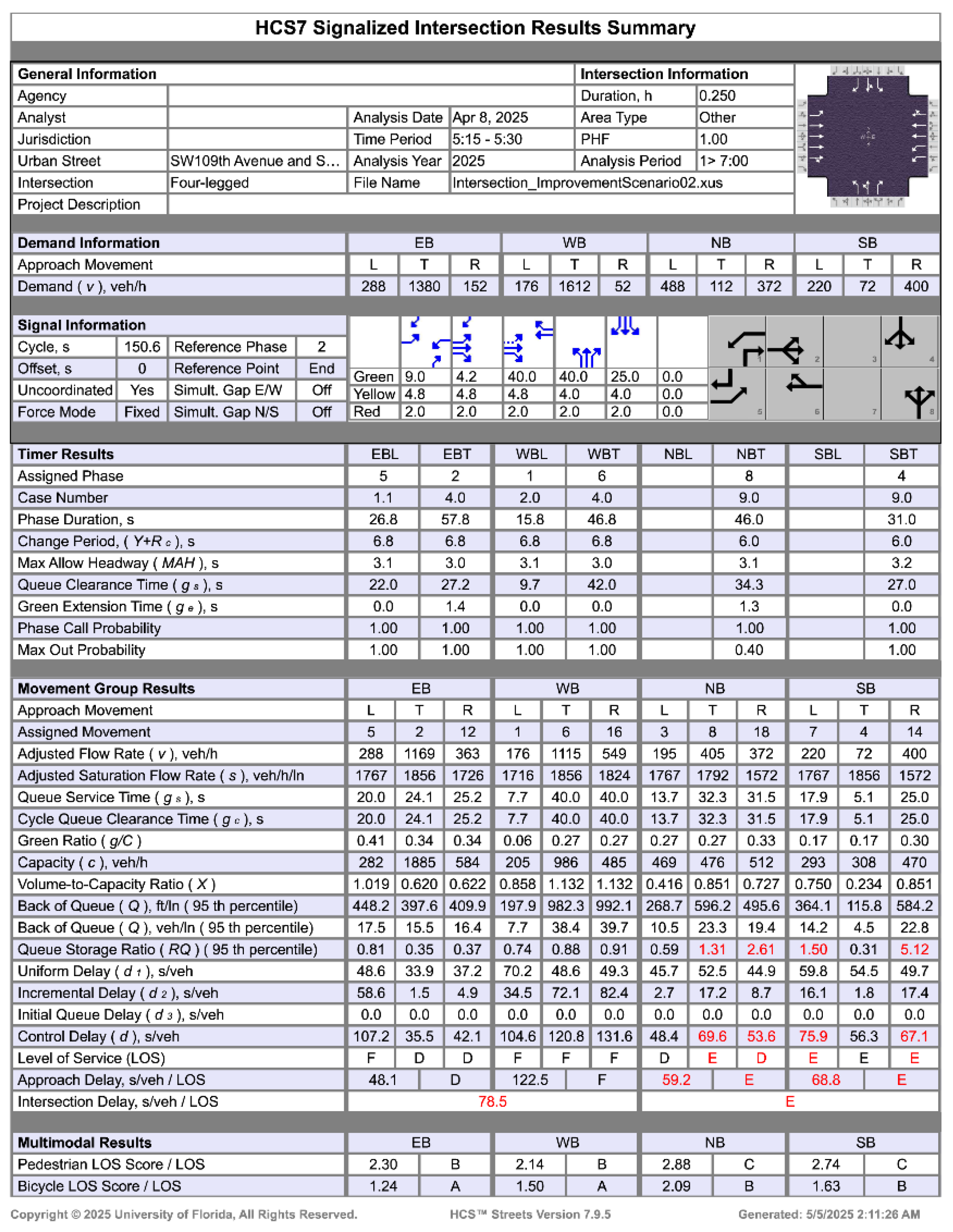
Figure A4.
Results of the Intersection from Improvement Scenario 2.
References
- Shirazi, M., Morris, B., & Zhang, S.; Intersection Analysis Using Computer Vision Techniques with SUMO; Intelligent Transportation Infrastructure, 2023; pp. 1 - 14.
- Rajab, N., Awad, H., & Alrawi, F.; Evaluation the Level of Service of Signalized Intersection: Al-Amreia Intersection as a Case Study; Proceedings of the 8th International Conference on Civil Engineering, 2022; pp. 18 – 30, Singapore: Springer. [CrossRef]
- Eriksen, A., Lahrmann, H., Larsen, K., & Taankvist, J.; Controlling Signalized Intersections using Machine Learning; Transportation Research Procedia, 2020; pp. 987-997.
- Marisamynathan, S., & Lakshmi, S.; Performance Analysis of Signalized Intersection at Metropolitan Area; Journal of Advanced Research in Applied Sciences and Engineering Technology, 2016; pp. 19-29.
- Hasan, J., & Hussein, N.; Traffic Assessment and Optimization at Signalized Intersections: A Review Study; Journal of University of Duhok, 2022; pp. 124-141.
- Galarza, M.; Losing Your Sanity in Miami Traffic? Study Ranks City Among the Most Congested in the World, 2023. Available online: NBC Miami: https://www.nbcmiami.com/news/local/losing-your-sanity-in-miami-traffic-study-ranks-magic-city-among-the-most-congested-in-the-world/2947172/ (accessed on 15th July, 2025).
- Salem, R., Zero, B., Omer, D., & Mohammed, G.; Improving the Level of Service and Capacity of Shorish Road in Erbil Using HCS7 and HCM2010; Eurasian Journal of Science and Engineering; 2025; pp. 24 – 37.
- Elzaher, A., & Albuquerque, F.; Signalized Intersections and Roundabouts: An In-Service Safety Performance Evaluation in Abu Dhabi; Transportation Research Procedia, 2021; pp. 268 - 275.
- Daglı, E., Aydın, M., & Stevic, Z.; Performance Evaluation of a Four-Legged Signalized Intersection with Variable Traffic Flow Dynamics; Mechatronics and Intelligent Transportation Systems; 2024; pp. 169 – 178.
- Wang, Z., Xu, H., Guan, F., & Chen, Z.; Statewide Intersection Geometry Extraction using Geographic Information System and Deep Learning Model from Road Maps; Journal of Intelligent Transportation System. [CrossRef]
- Glushkov, A., Shepelev, V., Vorobyev, A., MAvrin, V., Marusin, A., & Evtykov, S.; Analysis of the Intersection Throughput at Changes in the Traffic Flow Structure; International Conference of Arctic Transport Accessibility: Networks and Systems, 2021; pp. 192 – 199.
- Miami-Dade County Traffic Signal Documents; Available online: miamidade.gov: https://www.arcgis.com/apps/webappviewer/index.html?id=63841c188e2a4c71b2c138ae5167c6bb (accessed on 15th July, 2025).
- Transportation Research Board, Highway Capacity Manual 7th Edition; A Guide for Multimodal Mobility Analysis, 2022; Washington, DC: The National Academies Press.
- Pan, B., Liu, S., Xie, Z., Shao, Y., Li, X., & Ge, R.; Evaluating Operational Features of Three Unconventional Intersections under Heavy Traffic Based on CRITIC Method; Sustainability, 2021; 13(8), 4098. [CrossRef]
- Mohamed, A., Hashim, I., & Hassan, A.; A Comparative Analysis of Displaced Left-Turn and Four-Leg Signalized Intersections: Operational, Safety, and Environmental Perspectives; Journal of Engineering Research, 2024; 8 (1); Available at: https://digitalcommons.aaru.edu.jo/erjeng/vol8/iss1/24.
- Arshi, A., Alhajyaseen, W., Nakamura, H., & Zhang, X.; A Comparative Study on the Operational Performance of Four-leg Intersections by Control Type; Transportation Research Part A, 2018; pp. 52 – 67. [CrossRef]
- Federal Highway Administration. Safe System Roadway Design Hierarchy; Publication No. FHWA-SA-23-001; U.S. Department of Transportation: Washington, DC, USA, 2023. Available online: https://highways.dot.gov/sites/fhwa.dot.gov/files/2024-01/Safe_System_Roadway_Design_Hierarchy.pdf (accessed on 16 August 2025).
- Turner, S.; Roozenburg, A.; Francis, T. Predicting Accident Rates for Cyclists and Pedestrians; Land Transport New Zealand Research Report 289; Land Transport New Zealand: Wellington, New Zealand, 2006. Available at: https://www.nzta.govt.nz/assets/resources/research/reports/289/docs/289-Predicting-accident-rates-for-cyclists-and-pedestrians.pdf (accessed on 16 August 2025).
- Bai, Y., Zhang, X., & Nakamura, H.; A Comparative Study on the Operational Performance between Signalized Turbo Roundabouts and Signalized Intersections; Asian Transport Studies 7, 2021; 100033. [CrossRef]
- Abd-Allah, A., Hassanin, H., Ahmed, M., & Abdelsemii, A.; Evaluation of Common Traffic Operation Softwares on the Basis of Relevancy to Roads Intersections. Mansoura Engineering Journal, 2020; 41(2), pp. 16-26. [CrossRef]
- Al-Omari, B., & Ta’amneh, M.; Validating HCS and SIDRA Software for Estimating Delay at Signalized Intersections in Jordan. Jordan Journal of Civil Engineering, 2007; 1(4), pp. 375-392; Available at: https://www.researchgate.net/publication/320434529_Validating_HCS_and_SIDRA_software_for_estimating_delay_at_signalized_intersections_in_Jordan.
- Sistuk, V., & Monastyrskyi, Y.; Comparative Study of VISSIM and HCM Technique LOS Determination as Exemplified by T-Shape and Partial Cloverleaf Interchanges. Proceedings of the 1st International Scientific Conference on Current Problems of Transport, 2019; pp. 11-21. Ternopil. Available at: https://elartu.tntu.edu.ua/bitstream/lib/28725/2/ICCPT_2019_Sistuk_V-Comparative_study_of_VISSIM_11-21.pdf.
Figure 1.
Geometric condition of the intersection (Source: Google Earth, 2025).
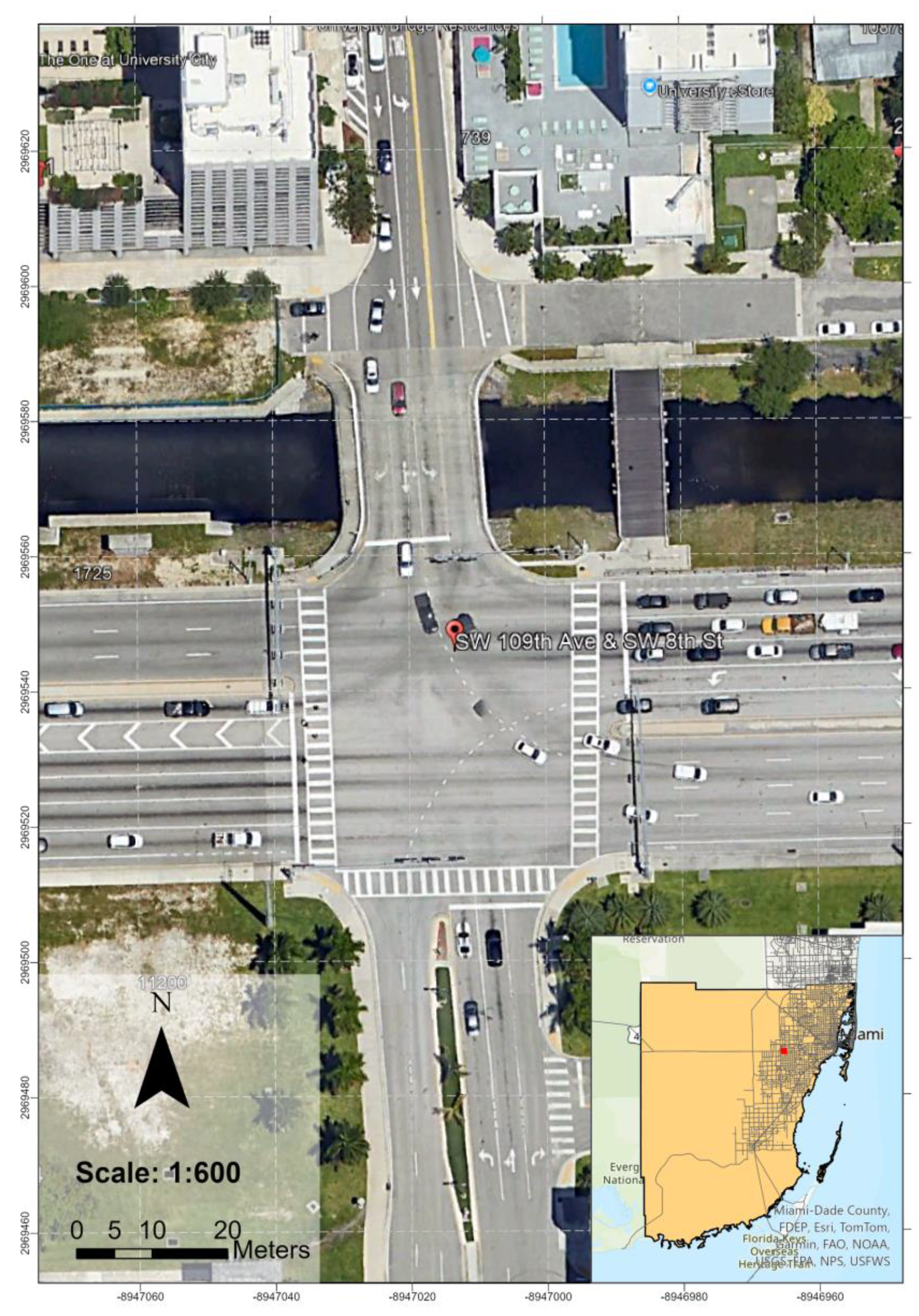
Figure 2.
Research Methodology. Source: Author, 2025.
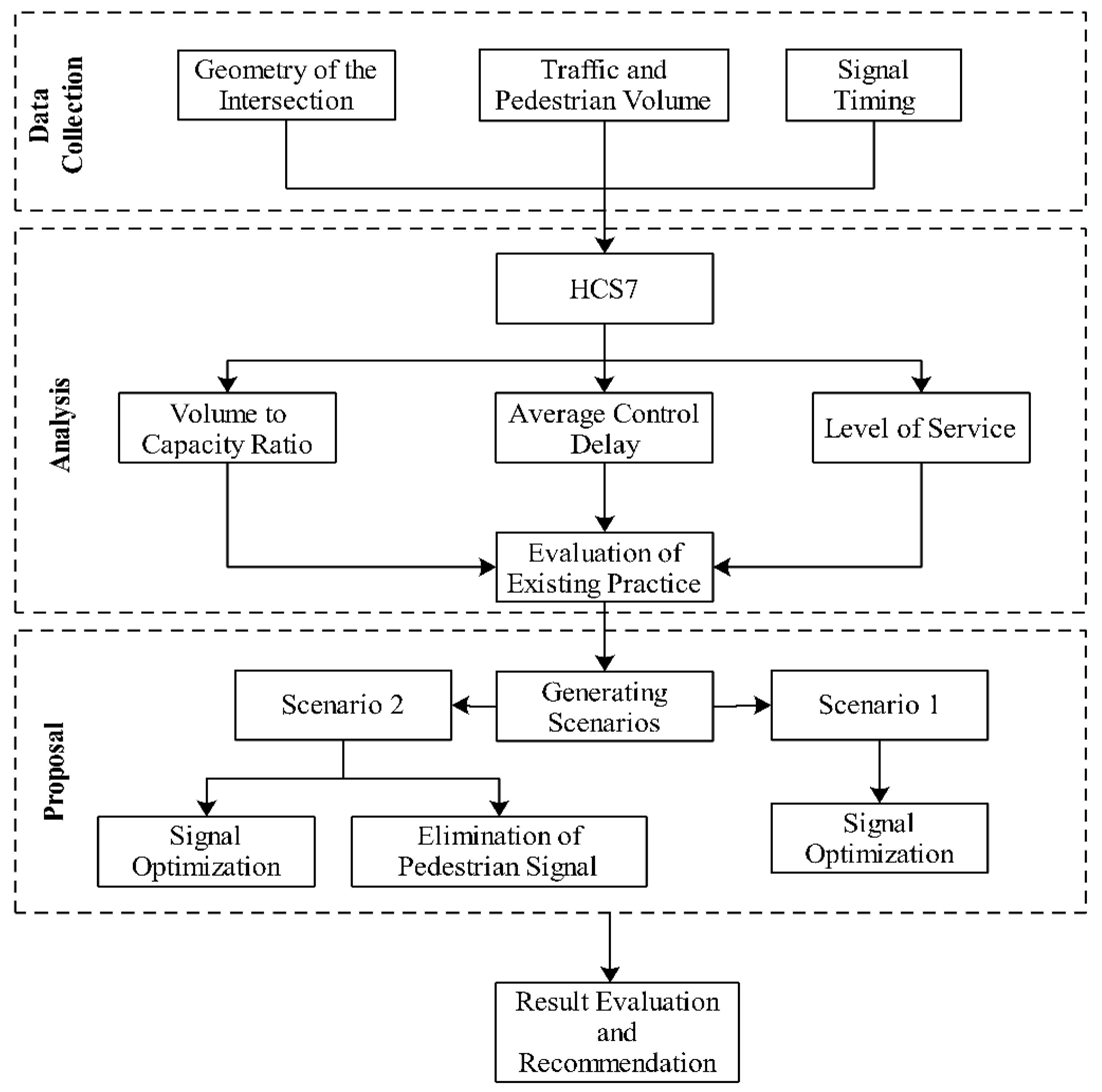
Figure 3.
Overlap Right-Turn Phase. Source: Google Street View, 2020.
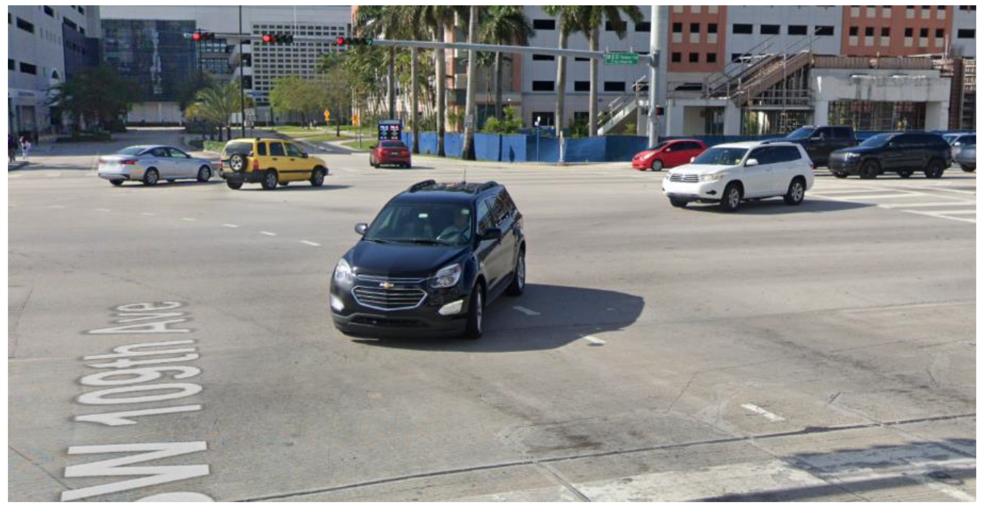
Figure 4.
Data Input and Configuration in HCS7 Software for Baseline Operational Performance Evaluation.
Figure 4.
Data Input and Configuration in HCS7 Software for Baseline Operational Performance Evaluation.
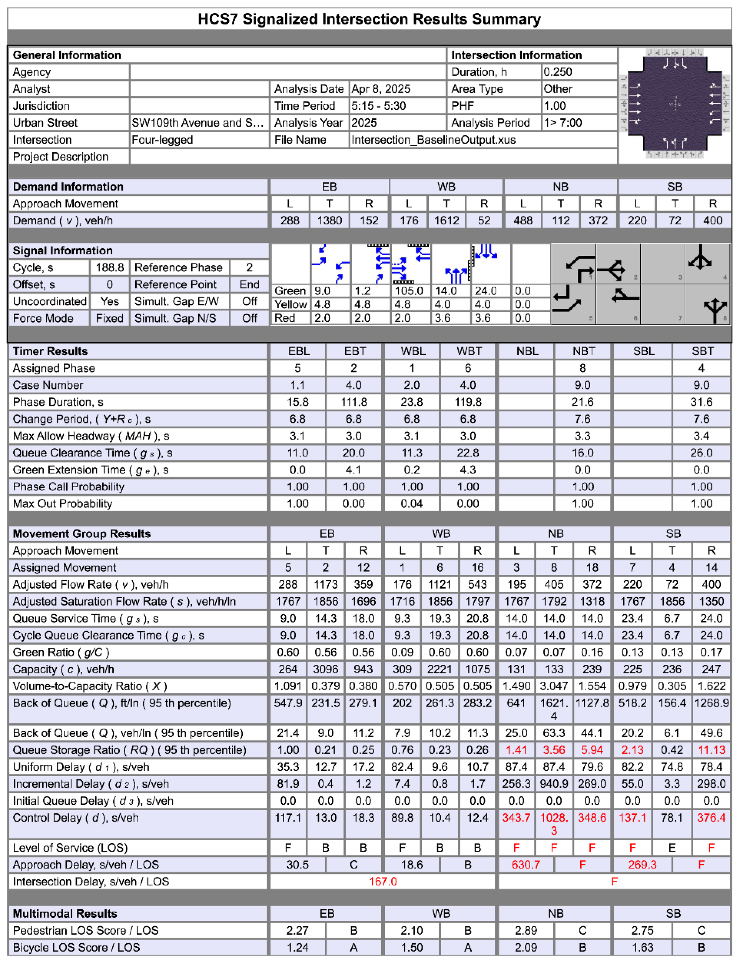
Figure 5.
Results of the Intersection from Baseline Scenario.
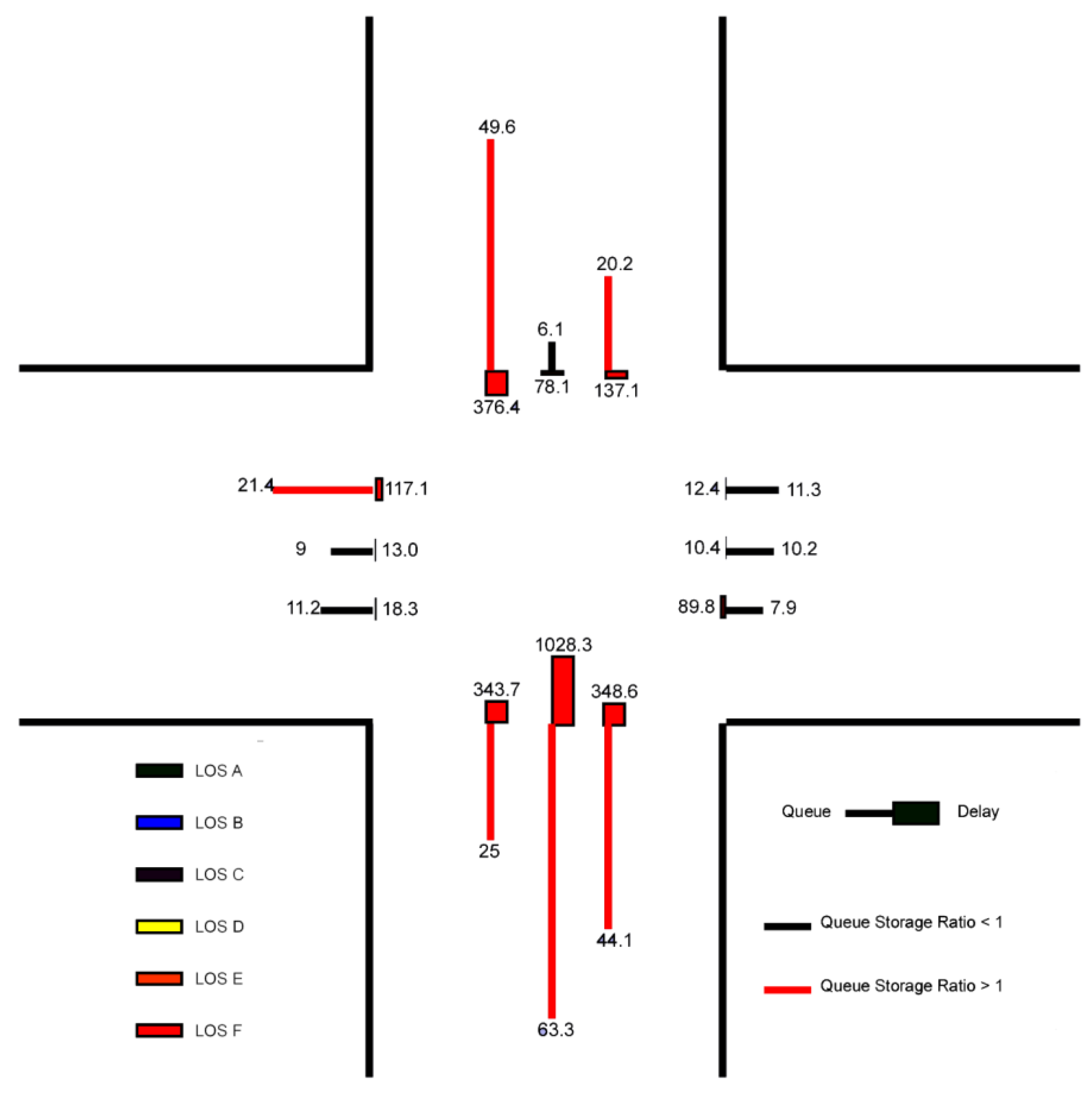
Figure 6.
Percentage change in maximum green time by movement between the baseline and optimized signal timing scenarios.
Figure 6.
Percentage change in maximum green time by movement between the baseline and optimized signal timing scenarios.
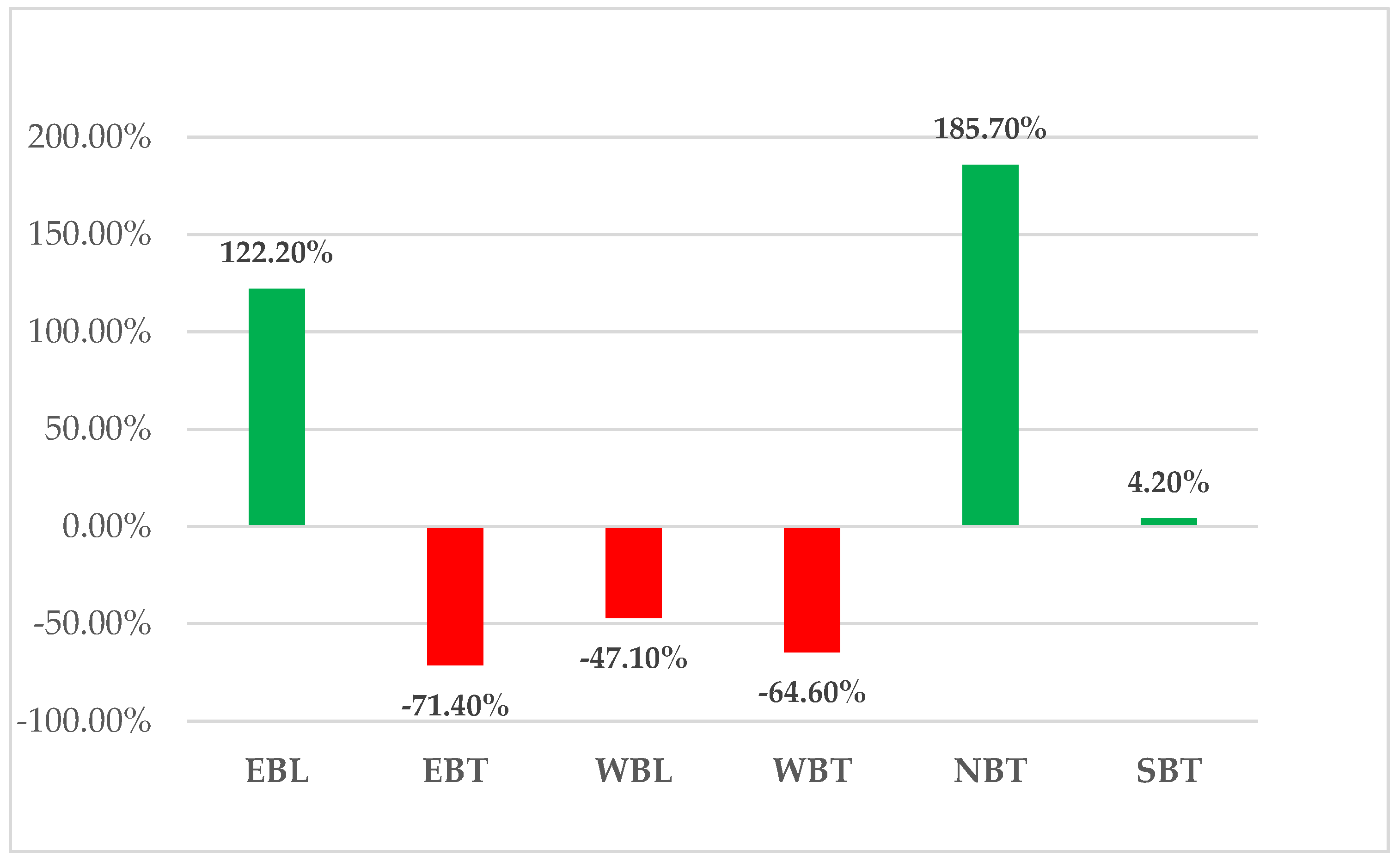
Figure 7.
Comparative performance of the intersection under baseline and improvement scenarios: (a) Queue Storage Ratio (RQ) by movement, (b) Level of Service (LOS) changes, (c) Intersection delay by scenario, and (d) Approach delay reduction.
Figure 7.
Comparative performance of the intersection under baseline and improvement scenarios: (a) Queue Storage Ratio (RQ) by movement, (b) Level of Service (LOS) changes, (c) Intersection delay by scenario, and (d) Approach delay reduction.
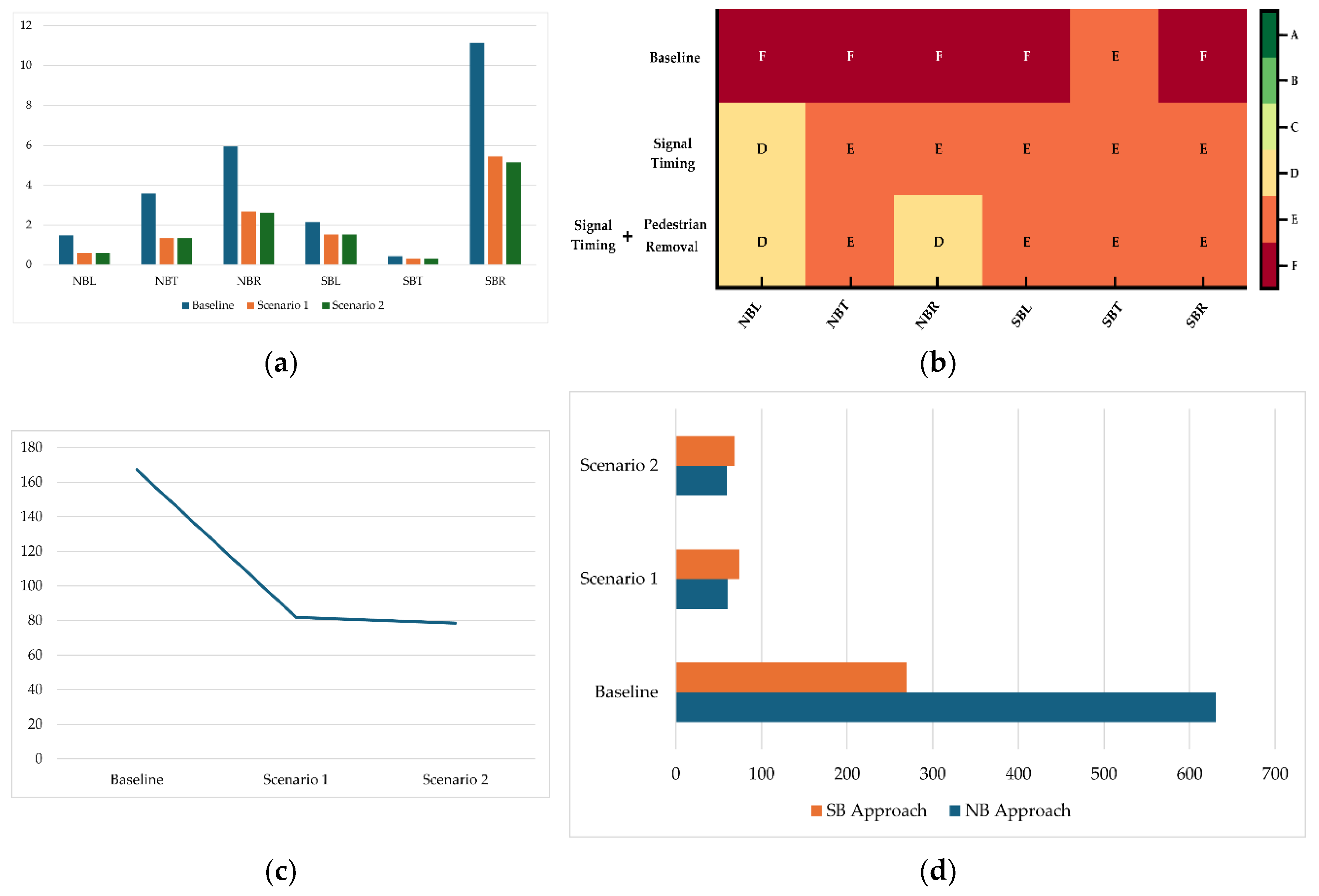

Table 1.
Storage Lengths and Lane Width of the Intersection.
| Storage Length of Lanes | |||||||||||
| Eastbound | Westbound | Northbound | Southbound | ||||||||
| Left | Thru | Right | Left | Thru | Right | Left | Thru | Right | Left | Thru | Right |
| 550 | 1121 | - | 267 | 1113 | - | 456 | 456 | 190 | 243 | 376 | 114 |
| Width of Lanes | |||||||||||
| Eastbound | Westbound | Northbound | Southbound | ||||||||
| Left | Thru | Right | Left | Thru | Right | Left | Thru | Right | Left | Thru | Right |
| 10.6 | 11 | - | 11 | 11 | - | 11 | 11 | 11 | 11 | 11 | 11 |
“- “ indicates there is no Right Turn movement in that direction. Source: Field survey, 2025.
Table 2.
Hourly Traffic Volume and Pedestrian Data.
| Eastbound | Westbound | ||||||
| Left | Thru | Right1 | Ped2 | Left | Thru | Right1 | Ped2 |
| 288 | 1380 | 152 | 64 | 176 | 1612 | 52 | 188 |
| Northbound | Southbound | ||||||
| Left | Thru | Right1 | Ped2 | Left | Thru | Right1 | Ped2 |
| 488 | 112 | 372 | 40 | 220 | 72 | 400 | 60 |
1 represents right-turn movement counts after subtracting RTORs. 2 represents pedestrian counts crossing in front of traffic.
Table 3.
Yellow Change & Red Clearance Times.
| Phase | Walk Phase | Don’t Walk | Min Initial | Veh Ext | Max Limit | Max 2 | Y | R | ||||||||||||
| 1 | 2 | 3 | 1 | 2 | 3 | 1 | 2 | 3 | 1 | 2 | 3 | 1 | 2 | 3 | 1 | 2 | 3 | - | - | |
| EBL | 0 | 0 | 0 | 0 | 0 | 0 | 5 | 5 | 5 | 3 | 2 | 1 | 7 | 7 | 5 | 36 | 20 | 36 | 4.8 | 2 |
| WBT | 5 | 5 | 5 | 20 | 20 | 20 | 18 | 18 | 18 | 2.5 | 2.5 | 1 | 45 | 45 | 26 | 0 | 60 | 60 | 4.8 | 2 |
| SBT | 5 | 5 | 5 | 29 | 29 | 29 | 7 | 7 | 7 | 2.5 | 5 | 1 | 12 | 12 | 10 | 40 | 25 | 32 | 4 | 3.6 |
| NBT | 5 | 5 | 5 | 28 | 28 | 28 | 7 | 7 | 7 | 2.5 | 2.5 | 1 | 10 | 10 | 10 | 31 | 15 | 32 | 4 | 3.6 |
| WBL | 0 | 0 | 0 | 0 | 0 | 0 | 5 | 5 | 5 | 3 | 2 | 1 | 7 | 7 | 5 | 47 | 20 | 27 | 4.8 | 2 |
| EBT | 5 | 5 | 5 | 20 | 20 | 20 | 18 | 18 | 18 | 2.5 | 2.5 | 1 | 45 | 45 | 26 | 0 | 60 | 60 | 4.8 | 2 |
Source: Miami-Dade County Traffic Signal Documents, 2025.
Table 4.
Maximum Green Time.
| Plan | Cycle | EBL | WBT | SBT | NBT | WBL | EBT | Offset |
| 1 | 140 | 13 | 54 | 23 | 20 | 13 | 54 | 36 |
| 2 | 160 | 17 | 64 | 27 | 22 | 9 | 72 | 103 |
| 3 | 180 | 28 | 62 | 31 | 29 | 15 | 75 | 68 |
| 4 | 190 | 28 | 81 | 31 | 20 | 20 | 89 | 57 |
| 7 | 160 | 18 | 74 | 24 | 14 | 18 | 74 | 65 |
| 9 | 160 | 18 | 67 | 31 | 14 | 13 | 72 | 156 |
| 11 | 170 | 17 | 85 | 24 | 14 | 13 | 89 | 126 |
| 12 | 190 | 9 | 113 | 24 | 14 | 17 | 105 | 127 |
| 13 | 160 | 16 | 55 | 29 | 30 | 17 | 54 | 111 |
| 14 | 140 | 17 | 36 | 28 | 29 | 17 | 36 | 10 |
| 15 | 120 | 6 | 31 | 26 | 27 | 6 | 31 | 3 |
| 16 | 120 | 9 | 45 | 19 | 17 | 9 | 45 | 32 |
| 17 | 120 | 9 | 45 | 19 | 17 | 9 | 45 | 36 |
| 18 | 130 | 7 | 47 | 24 | 22 | 7 | 47 | 90 |
| 20 | 150 | 12 | 53 | 28 | 27 | 6 | 59 | 27 |
| 21 | 160 | 23 | 48 | 30 | 29 | 19 | 52 | 9 |
| 22 | 130 | 10 | 43 | 25 | 22 | 7 | 46 | 3 |
| 23 | 120 | 10 | 33 | 25 | 22 | 7 | 36 | 3 |
Source: Miami-Dade County Traffic Signal Documents, 2025.
Table 5.
Relationship Between Arrival and Progression Quality.
| Platoon Ratio | Arrival Type | Progression Quality |
| 0.33 | 1 | Very Poor |
| 0.67 | 2 | Unfavorable |
| 1.00 | 3 | Random Arrivals |
| 1.33 | 4 | Favorable |
| 1.67 | 5 | Highly Favorable |
| 2.00 | 6 | Exceptionally Favorable |
Source: HCM, 2022 (7th edition).
Table 6.
LOS Criteria for Motorized Vehicle Mode.
| Control Delay (s/veh) | LOS by Volume-to-Capacity Ratio1 | |
| ≤ 1 | > 1.0 | |
| ≤ 10 | A | F |
| > 10-20 | B | F |
| > 20-35 | C | F |
| > 35-55 | D | F |
| > 55-80 | E | F |
| > 80 | F | F |
1 V/C ratio > 1.0 indicates oversaturated conditions, resulting in LOS F regardless of delay. Source: HCM, 2022 (7th edition).
Table 7.
Signal Timing Parameters: Baseline vs. Scenario 1.
| Timing | Assigned Phase | Eastbound | Westbound | Northbound | Southbound | ||||||||
| Left | Thru | Right | Left | Thru | Right | Left | Thru | Right | Left | Thru | Right | ||
| 5 | 2 | - | 1 | 6 | - | - | 8 | - | - | 4 | - | ||
| Baseline Scenario | Maximum Green |
9 | 105 | - | 17 | 113 | - | - | 14 | - | - | 24 | - |
| Yellow Change |
4.8 | 4.8 | - | 4.8 | 4.8 | - | - | 4 | - | - | 4 | - | |
| Red Clearance |
2 | 2 | - | 2 | 2 | - | - | 3.6 | - | - | 3.6 | - | |
| After Improvement |
Maximum Green |
20 | 30 | - | 9 | 40 | - | - | 40 | - | - | 25 | - |
| Yellow Change |
4.8 | 4.8 | - | 4.8 | 4.8 | - | - | 4 | - | - | 4 | - | |
| Red Clearance |
2 | 2 | - | 2 | 2 | - | - | 2 | - | - | 2 | - | |
Source: Miami-Dade County Traffic Signal Documents, 2025.
Disclaimer/Publisher’s Note: The statements, opinions and data contained in all publications are solely those of the individual author(s) and contributor(s) and not of MDPI and/or the editor(s). MDPI and/or the editor(s) disclaim responsibility for any injury to people or property resulting from any ideas, methods, instructions or products referred to in the content. |
© 2025 by the authors. Licensee MDPI, Basel, Switzerland. This article is an open access article distributed under the terms and conditions of the Creative Commons Attribution (CC BY) license (http://creativecommons.org/licenses/by/4.0/).
Copyright: This open access article is published under a Creative Commons CC BY 4.0 license, which permit the free download, distribution, and reuse, provided that the author and preprint are cited in any reuse.


