
Submitted:
29 July 2025
Posted:
30 July 2025
You are already at the latest version
Abstract
The Lunayyir Volcanic Field (Harrat Lunayyir) is situated on the western edge of the Arabian Microplate and represents a Quaternary volcanic area, containing ~150 vol-canoes formed from ~700 vents. The field includes effusive types—primarily pāhoehoe and ‘a‘ā lava flows—as well as explosive features such as spatter ramparts and mul-ti-crater scoria cones. Effusive eruptions are most prevalent and have long-term ef-fects, while explosive eruptions are generally low in intensity, although some have reached Volcanic Explosivity Index (VEI) 4 and dispersed ash over distances up to 250 km. Research suggests that recognizing the area's geoheritage and geodiversity may contribute to volcanic hazard resilience efforts. Possible strategies include geoconser-vation, hazard education, managed visitation, and creation of a geoheritage reserve to maintain current site conditions. Volcanic hazards in this area arise from dispersed monogenetic volcanic fields with eruption recurrence rates that span centuries to mil-lennia, complicating hazard communication. While infrequent, eruptions can affect regional assets. Communicating such hazards can be supported by the area's docu-mented volcanic geoheritage. In the northern development sector, 26 geosites have been catalogued, with 22 associated with the Quaternary basaltic volcanic field. Each geosite reflects a potential volcanic hazard and contributes to the basis for hazard re-silience planning.
Keywords:
geoheritage
; geodiversity
; geotourism
; volcanic hazard
; hazard resilience
; volcanic field
; monogenetic volcano
; lava flow
; scoria
; geosystem services
1. Introduction
This work draws on a combination of comprehensive desktop research using available geological data, alongside field observations to verify known and potential geological features in an area being considered for tourism development within the Northern Harrat Lunayyir region, part of a Pleistocene–Holocene monogenetic volcanic field [1,2]. The region is part of a broader Quaternary volcanic field regarded as active (Figure 1). Notably, recent volcanic features characterized by dark coloration contrast with the older, light-colored crystalline basement rocks, resulting in a distinctive landscape. This setting is under consideration for niche tourism, including adventure tourism and geotourism (Figure 1). Although relatively remote, the area remains accessible and has been identified as suitable for slow or recreational tourism strategies. The area’s young geological age, from Pleistocene to Holocene, contributes to its classification as an active volcanic field [3]. In 2009, volcano-seismic activity resulted in over 15,000 seismic events exceeding magnitude 2, leading to the relocation of approximately 40,000 residents [4,5,6,7,8]. This highlights the importance of incorporating volcanic hazard scenarios and mitigation assessments into development plans, especially those focused on geotourism. Volcanic and seismic hazard evaluations indicate that any future development will require significant research to better understand the region’s hazards. Collaborative efforts among end-users, investors, and scientists are recommended to develop effective mitigation strategies. Research suggests that further development should consider the geoheritage and geodiversity values of the area, which may offer a foundation for evidence-based geoheritage initiatives. These could include geoconservation, volcanic hazard education, and geoeducation through limited and controlled visitation, alongside the possible establishment of a geoheritage reserve to maintain the region’s current state. The site contains notable geological features that could be relevant for volcanic hazard resilience programs for both local communities and visitors. This article presents an estimate of the region’s geodiversity and provides systematic data to support the significance of its geoheritage, potentially contributing to applications for designations such as local, regional, or UNESCO Global Geopark status.
This report summarizes the main geological features of northern Harrat Lunayyir, emphasizing its major rock units and structural elements. The area is under strong development plan led by the Red Sea Global company. The development site defined roughly the core of a Quaternary volcanic field (Figure 1), while geotouristic investments soon planned in the northern side of the volcanic field, referred here as Option 4 area. Within this area is one of the youngest scoria cone-named here as Target Volcano-considered to be a pristine volcanic landform, considered as a main visitation site for geotourism.
Using satellite imagery and field observations, we identified key structures such as fissures, faults, folds, shear zones, and numerous dykes, with most detailed analysis limited to areas targeted for future tourism. The region is characterized by Neoproterozoic crystalline and magmatic basement exposures—primarily granitoid batholiths and some layered rocks like metasediments and metavolcanics—dominated by structurally controlled hills and valleys [9,10]. Lineaments observed in terrain and satellite data confirm strong structural influence, although few large surface faults or folds are mapped. Quaternary volcanic rocks, mainly mafic basalts from seven eruption phases (Qj, Qm1–Qm6), cover much of the area (Figure 1). The youngest units, Qm5 and Qm6, are difficult to distinguish due to limited data but are vital for assessing recent volcanic hazards. The rugged topography with narrow valley network determined by faults along horst and grabens formed clearly visible in the west to east topographic cross sections (Figure 2).
This report presents map visualizations and summaries of geological features in the northern Harrat Lunayyir, based on satellite data and limited field surveys examining joint surfaces, fault planes, and shear zones relevant for regenerative tourism. It outlines the main geological structures, rock units, and identifies 26 key geosites notable for their fragility and value in geoeducation and geotourism. Most sites are essential for understanding volcanic geohazards, highlighting the region’s significance in fostering community resilience through geoheritage. A comprehensive geodiversity map was also produced, combining geological and terrain elements to identify areas with high geodiversity. The research concludes that northern Harrat Lunayyir (Option 4 region of the Red Sea Global venture) is a major geodiversity hotspot, warranting inclusion in geo-conservation strategies and regenerative tourism initiatives.
2. Materials and Methods
Geoheritage, which refers to the geological component of natural and cultural heritage [11], encompasses features of geology at various scales that are considered significant for their scientific, educational, or cultural value. A geosite is an individual geological heritage asset [12], categorized similarly to other natural heritage elements such as biodiversity. Geoheritage includes features at global, national, state, and local levels that provide information about Earth’s evolution, the history of science, or that have utility in research, teaching, or reference [13]. Geotourism is a form of knowledge-based tourism that integrates aspects of the tourism industry with the conservation and interpretation of abiotic natural attributes [14]. It also considers related cultural aspects within geosites for public engagement. Geodiversity describes the diversity of abiotic elements in nature, often quantified by the density of geological and geomorphological features [15,16,17]. This assessment involves collecting data on various geological units, minerals, soils, water sources, and parameters that objectively measure terrain morphology. In some cases, geodiversity is further assessed using a value scale based on the relative abundance and significance of specific features, such as assigning higher weights to rare rock types [17,18,19]. In this context, we used a geodiversity estimation method that identifies areas with both high feature density and higher values for educational, scientific, tourism, and conservation purposes [20,21]. While this approach involves uncertainties, recent evidence suggests it is an effective and efficient way to locate regions with notable geodiversity, which may indicate potential geosites [22,23,24,25]. Figure 3 provides a summary of the evaluation point system employed. Of the various terrain analysis methodologies available, our evaluation focused on terrain ruggedness (https://docs.qgis.org/3.34/en/docs/user_manual/processing_algs/qgis/rasterterrainanalysis.html), which measures variations in elevation and their relationship to neighboring units. Ruggedness is used as a proxy for landscape definition, offering additional context beyond slope angle measurements alone. For geological features, lower scores were assigned to Quaternary surficial deposits and higher scores to the youngest volcanic landforms (see Figure 3). The calculation of geodiversity to the whole region has been performed on a 2.5 km wide grid network using QGIS and its inbuilt plugins.
The research relied on direct geological observations and fieldwork to verify terrain analysis data. Geosite identification was guided by local and regional geological context, site representativeness, abundance, accessibility, landscape features, and visibility—even for non-experts. Selection combined desktop studies with repeated cross-checks between literature and field data. This work followed established Geosite Assessment Methods, particularly Brilha’s approach [13,26]. A comparative study of significant geological heritage sites in Saudi Arabia and internationally highlighted the region’s volcanic geoheritage, supporting its value for volcanic hazard resilience education.
3. Results
3.1. Key Geological Heritage Elements
3.1.1. Neoproterozoic Basement Rocks
The oldest rocks in the study area are Neoproterozoic, with some numeric age data available. These rocks form steep-sided horsts separated by long valleys trending NW-SE and SW-NE, likely shaped by deep structural features and shear zones between basement blocks. Mapped at a 1:250,000 scale using data from the Saudi National Geological Database (DS_250K_GM_053C sheet), the main rock types include tonalite, monzogranite, and syenogranite, which dominate the northern landscape.
Tonalite
Tonalite is a coarse-grained, felsic, intrusive igneous rock composed primarily of plagioclase feldspar (usually oligoclase or andesine) with less than 10% alkali feldspar, and over 20% quartz in its QAPF content. Accessory minerals include amphiboles and biotite. Unlike older definitions equating tonalite with quartz diorite, current IUGS guidelines define tonalite as having >20% quartz, while quartz diorite contains 5–20%. In the study area, two tonalite types—tn1 (more mafic, gabbroic) and tn2—have been identified, both part of the Jar Tonalite dated to 745–695 Ma. The rocks are generally light beige and intersected by mafic dykes that create distinct landscapes. Tonalites, along with granodiorites, typify calc-alkaline batholiths above subduction zones, making these sites valuable for geoeducation and geotourism by highlighting the magmatic evolution of the Arabian Shield.
Trondhjemite
Trondhjemite, a light-coloured intrusive igneous rock (https://www.mindat.org/min-51928.html), is exposed in the NE sector of the study area (Figure 1). It is a tonalite variety with mainly oligoclase plagioclase. When found in oceanic crust or ophiolites, trondhjemites—often called plagiogranites—indicate oceanic crust obduction. In this study, their association with mafic layered rocks suggests they are remnants of ancient oceanic crust, labelled ‘gd’ and confined to eastern surface sectors. Common in Archean terranes like the Arabian Shield, trondhjemite typically appears alongside tonalite and granodiorite as part of the TTG suite and often forms dikes within ophiolite complexes.
Monzogranite - Syenogranite
Monzogranites and syenogranites are the main crystalline basement rocks in the Option 4 area (Figure 4). Monzogranite, a plutonic rock, contains 20–60% quartz, with the rest mostly alkali feldspar and plagioclase. While monzogranite is transitional among granitoids, syenogranite resembles typical granite, distinguished by its pink hue from hematite-rich orthoclase. Syenogranite is coarse- to fine-grained, felsic, and mainly contains alkaline feldspar (usually orthoclase), 15–25% quartz, biotite, muscovite, rutile, and occasionally rare amphiboles (Fe-hornblende, Fe-edenite) and annite-rich biotite (25–35%). Plagioclase (An3), K-feldspar, and quartz are also present. The central part of the Option 4 area features a prominent semicircular hill made of monzogranite from the Khanzira Complex, likely of Neoproterozoic age and slightly younger than the nearby Jar Tonalite ranges. This hill, characterized by light pinkish granite partly covered by Holocene volcanic ash, shows typical weathering with rounded blocks and fragmented material. The region contains numerous mafic dike swarms trending east-west, visible on satellite images as they curve around the central monzogranite body.
3.1.2. Oldest Quaternary Volcanic Rock Units
Harrat Lunayyir is a monogenetic volcanic field in western Saudi Arabia, consisting mainly of small to medium scoria cones, spatter cones, and pāhoehoe lava flows. Eruptions began around 600,000 years ago. The oldest Quaternary volcanics, marked as Qj, are found in the southern perimeter but are absent in Option 4. Their features are best seen along the Umlujj–Al Ays highway, where erosion has heavily modified the lava lobes and many source vents are unrecognizable. These ancient flows often form cascades with distinctive surface textures due to the rugged terrain. Younger volcanic rocks are mostly in the north and central areas. In Option 4, the oldest rocks belong to the Qm1 series in the north, Qm2 in the south, and Qm3 in the east (Figure 5).
Youngest Volcanics
The youngest volcanics in the region, formed during the Holocene, are classified as Qm5 and Qm6. These lava flows are visually similar, both displaying fresh surface textures. The volcanic cones remain intact without major gully networks, and their craters are well preserved, lacking substantial rock falls or surface deposits.
Lava Flows
Basaltic magma with low viscosity tends to produce lava flows that exhibit typical pāhoehoe surface textures. Pāhoehoe generally forms when lava has erupted at a slow rate and moves slowly over gently sloping ground [27]. In the study area, the main valley network has a low slope angle, which is suitable for pāhoehoe formation. However, pristine pāhoehoe surfaces are relatively uncommon in the field, suggesting that either the pre-eruptive landscape included characteristic steps where lava could accelerate, or the eruption rates were high during most eruptions. Both factors contributed to the prevalence of transitional lava flow types as the dominant surface textures in the study area. Pāhoehoe flows may move as sheets, within lava channels, or through lava tubes. Sheet and channel development are mainly observed along the main streamline of former lava flow paths, as documented in the youngest flow fields in Option 4. Lava tubes form when the cooled crust insulates the interior, allowing molten lava to continue moving [27,28,29]. Even after cooling, if lava continues to be emitted from the vent into the body of the flow, inflation can occur. Inflation and deflation features are observed in the Option 4 lava fields (Figure 6), indicating a history of emplacement by low-viscosity lava. Petrographic thin sections show that these flows are microcrystalline and contain abundant olivine microphenocrysts and aggregates. Crystallinity increases with distance from the source due to surface cooling. Pāhoehoe flow fronts typically advance as small lobes or toes breaking out from the cooled crust [30,31], especially visible along the margins of extensive flow fields such as Qm5 and Qm6. Pāhoehoe surfaces are often ropy, billowing, hummocky, or smooth. Subtypes described include smooth, ropy, hummocky, shelly, slabby, spiny, toothpaste, and entrail forms. Ropy pāhoehoe, known for its distinctive appearance, forms when shear strain accumulates at the surface as flowing lava drags the cooling crust. While extensive regions of ropy pāhoehoe are rare in the Option 4 area, localized occurrences can be seen in flat areas, such as the northern edge of the Qm6 field. Shelly pāhoehoe develops in gas-rich flows where gas exsolves, creating tubes and blisters beneath thin surface crusts. This subtype is observed near the source of Qm6 flows in Option 4. Slabby pāhoehoe, characterized by jumbled plates or slabs of broken crust, represents a transition to ‘a‘ā lava when the surface cannot accommodate the strain rate. It remains fluid enough to display pāhoehoe features and is common in the Option 4 area. Rubbly pāhoehoe, an even more fragmented variant, produces blocky clasts like those found in aa flows. Transitions from pāhoehoe to aa surface textures are evident in the lava fields, reflecting cooling and mechanical disruption of the crust and resulting in a rubbly succession of the flow mass [32]. The Option 4 lava fields exemplify Hawaiian-type transitional flows. Slabby pāhoehoe forms under high strain rates that approach conditions for aa, but the lava remains too fluid to fragment completely. Spiny pāhoehoe occurs under very low strain rates when the lava is crystalline and viscous, forming rough surfaces [33]; this subtype is typical in distal marginal flows in Option 4. The abundance of slabs in slabby pāhoehoe results from disruption of an initially flat pāhoehoe surface, with slabs displaying a range of brittle to ductile deformation. This disruption is usually caused by surges of lava associated with high strain rates, particularly in large, sheet-like lobes. In Hawaii, slabby pāhoehoe rarely extends beyond a kilometer before transitioning to classic aa or reverting to pāhoehoe if the flow rate decreases. At Option 4, the Qm6 lava flows demonstrate similar relationships between distance and surface texture.
Ash Plain
A defining feature of the Option 4 region is its extensive ash plain (Figure 7), formed by explosive mafic volcanic eruptions, likely originating from the Target Volcano based on pyroclast distribution and composition. The ash plain consists of coarse-grained, lapilli-sized material near the source, transitioning to finer ash farther away. Proximal pyroclasts exhibit a bluish tint due to high-temperature titanium minerals and are highly vesicular, making them lightweight and capable of traveling great distances. These low-density particles are easily eroded from peaks and contribute fine ash to alluvial systems, indicating widespread ash coverage up to 10 km from the vents. The north-northwestward spread and estimated plume height of up to 10 km suggest sub-Plinian eruptions like Paricutin, Mexico [34,35]. Microscopically, ash and lapilli display glassy, sharp-edged textures and irregular vesicles, posing potential health risks if inhaled or if entering cooling systems. Their high surface area allows absorption of chemicals, increasing hazard potential during eruptions. Accumulated ash mixed with local dust can be re-released by activities like excavation or driving, raising concerns about carcinogenic zeolites such as erionite [36]. The region also contains scoria cones and numerous degassed lava bombs and blocks—often spindle-shaped due to ballistic transport—with compositions typical of basaltic rocks rich in plagioclase microlites and olivine microphenocrysts.
3.1.3. Quaternary Surficial Sediments
The Option 4 area and its surroundings contain significant Quaternary surficial deposits, including alluvial fans, valley-filling sediments, and sabkha deposits that have accumulated in closed, temporary shallow lakes. These deposits consist of particles from nearby crystalline basement rocks, various basaltic volcanic materials, and fine-grained aeolian silts with locally occurring salt and zeolite minerals. Nearby valley networks adjacent to the crystalline basement are filled with light-colored sand and silt, while areas close to the former ash-covered ridges contain black reworked ash.
3.2. Geodiversity of Harrat Lunayyir
Geodiversity mapping shows that areas with steep, rugged terrain and young volcanics—highlighted in dark red on Figure 8—have the highest geodiversity. Comparisons with basement, Qm5, and Qm6 volcanics reveal that Option 4 represents a significant geodiversity hotspot with many valuable geosites.
3.3. Geosite Recognition for Northern Harrat Lunayyir
Geosites are distinctive locations with notable geological or geomorphological features within a given area. The most valuable geosites are those recognized at regional or global levels. Their identification relies on understanding local geology and geomorphology—here, specifically in the Option 4 area—using a transdisciplinary approach. Based on our prior studies, we identified 26 geosites in this region (Figure 9), which are briefly described with both textual and visual information. Table 1 summarizes these sites and their geographic locations.
Each of these sites can serve as a destination within both self-guided and organized tours and may be incorporated into geotrails—a widely adopted approach in geotourism development globally [37,38,39,40,41]. Geosites may subsequently be assessed using standardized and internationally recognized criteria [13,26]. Initially, we provide detailed descriptions of geosites and then present an evaluation to substantiate the rationale behind their selection. For clarity, the areas have been subdivided into smaller regions to better illustrate the comprehensive geological insights these locations offer to visitors.
The northernmost region, situated just outside Option 4 territory yet in close proximity to it, comprises a complex system of older scoria and spatter cones occupying a relatively small valley within the Neoproterozoic basement. Geosites are designated as GS with numbers ranging from 1 to 26. GS1 features a scoria cone complex from an ancient volcano that retains relatively well-preserved geomorphology despite noticeable erosion (Figure 10). This site provides valuable insights into advanced stages of erosion over several hundred thousand years, serving as a useful comparison to younger volcanic geosites (Figure 11). The nearby Neoproterozoic basement is intersected by mafic dike swarms, offering convenient opportunities to observe and examine these rocks firsthand at GS2. At the entrance to this valley network lies an archaeological site marked by circular stone formations on the desert floor, making it one of the most accessible and intricate geoarchaeological locations within the Wider Area of Interest (Figure 12).
Superb geosites are found along the northern edge of Option 4’s main access road, showcasing older scoria cones and lava flow margins (Figure 13). GS4 is a prime example in the study area, illustrating how scoria cones develop over rugged terrain (Figure 14). The agglutinated lava spatter core of the scoria cone forms an erosion-resistant center that preserves the Neoproterozoic basement below
The preservation of a scoria cone in steep, rugged terrain is an uncommon occurrence; this geosite allows visitors to consider the primary factors influencing cone growth and their preservation. This location is not only relevant within the study area but also holds global significance for research in volcanology.
GS7 is a geosite that preserves a Qm1 scoria cone (Figure 15) with considerable integrity. The outer flank of the cone shows well-developed gully systems, suggesting the cone existed during pluvial periods when these features gradually formed on its sides. Despite the gullies, the volcano’s original shape remains largely intact, including a preserved crater and rim attributed to the welded pyroclastic collar at the crater lip [42]. These characteristics suggest the volcano is relatively young and corresponds to models of scoria cone degradation and morphometry, indicating that a volcano less than a million years old would be expected to have similar features [43,44,45,46,47,48,49,50].
GS8 is a location that connects well to the GS7 as easy access to the former crater of a scoria cone reveals the densely welded nature of the preserved pyroclasts forming a castle like skeleton of the former volcano, keeping the core of the volcano preserved. Just next to GS8 cone, the young Qm6 lava flow reaches a region blocked by the GS7 scoria cone, demonstrating interesting interaction features of slabby pāhoehoe lava flow margin development. At GS8, deflation and inflation features can be observed indicating typical pāhoehoe lava flow evolution stages that makes this geosite unique within Option 4 area.
The lava flow margin features are prominent within the study area. GS5 serves as an example illustrating that the original lava infill was elevated within the longitudinal valley network adjacent to the Option 4 territory. This geosite allows for observation of large-scale lava flow behavior within confined environments such as a narrow valley network.
GS9 is a sabkha situated within a closed basin formed by multiple lava flows. These regions are located near the elevated peaks of the basement, where runoff water gathers and forms temporary lakes. The silts present in the lake beds can become sources of dust when strong winds occur.
Situated slightly apart from Option 4, is an older, complex scoria cone designated as a geosite due to its distinctive structural characteristics (Figure 16). This scoria cone complex developed within a locally open area at the intersection of narrow valleys (Figure 17), resulting in the formation of an amalgamated system with overlapping volcanic edifices. The intricate architecture of the site is exposed by local quarrying activities, which allow access to various types of scoria layers. Within the quarry, large, degassed volcanic bombs and blocks are present, serving as evidence that active craters periodically accumulated molten material, which solidified before being expelled as clasts during subsequent eruptive events.
Visitors can access the interior of the area via a walking path originating from the main 4WD road (Option 4). The terminus of the 4WD track marks an ideal geosite (G12), distinguished as one of the largest debris fans accumulating eroded ash and lapilli from the monzogranitic hilltops. As one approaches the Target Volcano, the footpath traces the boundary between the Qm6 lava flows, alluvial fans, and the principal basement horsts. GS13 provides optimal exposure to the monzogranite basement due to its accessibility. Additional geosites, including GS11, GS14, and GS15, illustrate various features of slabby pāhoehoe lava flow margins. GS16 represents a primary ash-dominated fan.
Upon reaching the Target Volcano (Figure 18), the GS17 region is characterized by numerous volcanic bombs scattered across a recently deposited ash plain, illustrating the dominant path of ballistically ejected material from the nearby primary vent. This area is extremely fragile and should be subject to stringent conservation measures. Most bombs remain within their respective impact craters, highlighting the eruption’s recent occurrence.
GS18 designates the geosite at the main volcanic cone itself. The cone exhibits steep, challenging terrain that requires careful access to minimize the risk of accidents and prevent the formation of artificial gullies that may compromise its structural integrity. The crater displays a complex morphology, indicative of multiple episodes of collapse, spreading, and subsequent healing.
On the northeast flank of the cone lies a notable closed basin, providing an exemplary site for observing arid sedimentation processes. Here, flash flood deposits, rockfall debris, and sheetwash sediments accumulate, progressively filling a narrow valley less than one kilometer wide (Figure 19). In the western sector of the central cone, an undisturbed ash plain remains preserved, representing a highly sensitive environment where access should be strictly regulated.
Pioneer vegetation is starting to colonize the area, highlighting the geo-ecosystem’s fragility. Westward, at the edge of the Qm6 lava flows, cooling and crystallization have led to spiny pāhoehoe to ‘a‘ā lava transitions, resulting in unique rock formations that distinguish GS21 as a notable geosite (Figure 20). The most remote part of Option 4 features a complex geotope with five distinct geosites (Figure 21), where two Qm2 scoria cones are surrounded by Qm5 and Qm6 lava flows, creating a striking landscape. These old cones have well-developed gully networks in ash and lapilli deposits, forming striking black gullies. Like GS22 (Figure 22), the ash base can be accessed via gullies (Figure 69), which is crucial for studying initial explosive eruption deposits and understanding the volcano’s eruption mechanisms. On the west side of the Qm2 cone, over 2 m of primary pyroclastic succession remains preserved (GS23), showing about a dozen layers that indicate multiple explosive eruption events. In the western edge of the Qm2 scoria cone at GS24 and GS25 a spectacular view shows the complex interaction between cones; ash falls and young lava flows.
3.4. Geosite Assessment from a Global Perspective
Identified geosites are typically evaluated against international standards. One widely endorsed approach is the Brilha method [26], which assesses geosites based on expert evaluation from scientific, educational, touristic, and degradation risk perspectives. Although this methodology was originally designed with geoeducation and geotourism in mind—primarily within developed regions—its evaluation criteria often reflect priorities that may not be entirely applicable to remote areas such as Harrat Lunayyir. Despite these limitations, we applied this framework and obtained noteworthy results (see Table 2, Table 3, Table 4 and Table 5), indicating that the nominated geosites possess significant value and uniqueness. However, tourism and accessibility remain underdeveloped. As a result, Option 4 presents the most suitable site for geotourism and geoeducation development; nevertheless, improvements in local tourism and infrastructure could enhance geosite value while simultaneously increasing degradation risk. Consequently, it is essential to balance these competing trends through strategic planning. To illustrate this, we compared the Target Volcano area with the globally recognized Al Wahba maar crater in Harrat Kishb [51] (Table 6). While the Target Volcano demonstrates comparable scientific and overall value to Al Wahba, its limited infrastructure restricts its geotouristic potential. This observation further highlights the need to consider methodological biases toward developed world tourism when evaluating remote or niche geotourism destinations. Considering the final value, degradation risk (DR) can be classified in three classes: low (less than 0.2), moderate (0.2-0.3), and high (more than 0.3). The calculation of the values is given in each table captions.
4. Discussion
The study region is a relatively remote, low population density area with extensive dirt road network and tracks. The area is pristine, and its volcanic landscape can be considered as a region where the basic characteristics of a typical basaltic monogenetic volcanic field geological features are well exposed, well preserved and within a small area representing all the known volcanic hazard types and their geological record. The arid conditions while generating thick surficial deposits, especially along major wadi network, the volcanic landforms are exceptionally well preserved to be able to see fine details of the scoria and spatter cone architectures and their extensive transitional pahoehoe lava flow fields. In global comparison such intact volcanic regions are rare, and probably comparable places exist in the SW USA, NW Mexico and some places in the arid places in NE Africa. The advantage however in the case of Harrat Lunayyir, that it is still accessible relatively easily, and the current tourism development initiatives can develop the regions further to be global reference points to continental monogenetic volcanic fields dominated by magmatic explosive and effusive processes. The estimated geoheritage values in combination with the geodiversity hot spots showed that the key geosites are among those areas where the youngest volcanism occurred leaving behind still intact volcanic landforms. For a regional comparison while the volcanic fields geoheritage has been documented in various studies in the last decade [52,53], relatively rare those studies that are qualitatively estimated a volcanic region geoheritage values especially their significance from geotourism perspective [51]. In narrative description it provides good overview of the geoheritage and geodiversity of western Arabia and within that Harrat Lunayyir is among the most compact region (e.g., in a smallest areas the greatest diversity of valley confined lava flows, and typical magmatic explosive eruption-generated volcanic landforms preserved [52]. In comparative perspective, there are a geosite, Al Wahbah maar crater that has been recently listed (2024) in the Second 100 International Union of Geosciences Geological Heritage list [https://iugs-geoheritage.org/geoheritage_sites/the-pleistocene-al-wahbah-dry-maar-crater/ - accessed on 28 July 2025], from where a Geosite Assessment have been performed in 2012-2013 [51] provides a good comparative site to see how the Option 4 area with its Target Volcano perform against Al Wahbah maar. The calculations tabulated in Table 6 providing estimated values for the Option 4 area at Harrat Lunayyir. The data extracted from the 2012-2013 research from Al Wahbah represent relatively old data that slightly changed as the Al Wahbah maar crater been listed in the Second 100 IUGS Geological heritage Site list, some tourism development increased the additional values of the region slightly. Still, the comparative analysis showed that while the current underdevelopment in tourism at Harrat Lunayyir reducing the location touristic values, its pristine nature as well as its young, still active conditions due to frequent volcano-seismic activity, compensate the estimated values, indicating that a well-designed geotorusim and Geoconservation program would skyrocket the Harrat Lunayyir to be premier, globally significant locations for geohazard resilience utilizing the region volcanic geoheritage.
The volcano-seismic activity of the region and the identified volcanic hazard scenarios provided important information to investors that any development in the region faces with significant volcano-seismic hazard that is also highly unpredictable. While the hazard estimates indicate relatively low intensity hazard types, their potential destructive power, or hazard appetite could be considerable large including destruction of built environment by lava flows difficult to control if eruption initiates [1,2]. This finding and the exceptional geoheritage values of the well-preserved geo-features representing specific, key volcanic hazard elements suggesting that Geoconservation and geohazard education could play a key role in future geotourism development in the region. This is perfectly justified by the pristine natural volcanic environment that is globally rare feature, especially its well-defined geographical extent and the relatively slow recurrence rate of volcanism expected in the region (e.g., in the Harrat Lunayyir no active volcanism tourism operation need to deal with, while the preserved landscape mimicking a landscape provides an impression it was created very recently). In hazard and risk estimates, for medium to long term tourism development therefore it is more beneficial to invest in geoconservation and preservation of the pristine volcanic landscape to use it for scientific research as well as geoeducation through geotourism managed through daily guided visits and low investment site development, geotrail design and geoguide trainings to reduce potential risk of loss of built facilities in case of volcano-seismic unrest. This approach would likely be accompanied with strong link between hazard specialists and responsible monitoring entities to maximize the region volcanic geoheritage to use for geohazard communication to the local communities as well as for visitors.
5. Conclusions
This report identifies the principal rock types, structural features, and geoheritage values present in the study area. The findings establish a solid foundation for developing a comprehensive and informative geological map of the region, with a particular focus on the Option 4 area, which will be addressed in detail in the subsequent report. The primary conclusion of this work is that the Option 4 area exhibits exceptional geological and geomorphological diversity, providing strong justification for potential geotourism development. The region has also been recognized as a geodiversity hotspot, with 26 distinct geosites nominated. These geosites were evaluated using globally recognized methodologies, and all met the criteria necessary for consideration in future geotourism and geoeducation initiatives. However, it should be noted that nearly half of these geosites are in highly fragile environments, necessitating robust conservation measures to preserve their integrity and minimize the risk of degradation. To utilize the region volcanic geoheritage for geohazard education geotrail development can offer sustainable landscape management, highlighting the area’s detailed volcanological features that can enhance geoeducational opportunities.
Author Contributions
“Conceptualization, K.N. and V.Z.; methodology, K.N and V.Z.; software, A. S and V.Z.; validation, K.N., T.M., M.A., V.S., F.M., T.H, T.S., K.A: and K.Y.; formal analysis, K.N. and V.Z. ; investigation, K.N.; resources, K.N., A.S., T.S. and K.Y.; data curation, K.N, A.S. and V.Z..; writing—original draft preparation, K.N.; writing—review and editing, A.S., M.T:, M.A., V.S., F.M., K.A., T.H., T.S., and K.Y.X.; visualization, K.N., A.S. and V.Z.; supervision, K.N.; project administration, A.S.; funding acquisition, K.N, A.S., T.S. and K.Y. All authors have read and agreed to the published version of the manuscript.”
Funding
“This research was funded by the Red Sea Global – Saudi Geological Survey Project Contract”
Data Availability Statement
All data used in this research used in the manuscript presented here.
Acknowledgments
We are acknowledging the support given to conduct this research by the National Program of Earthquakes and Volcanoes of the Saudi Geological Survey. The Authors are also thankful for the reviewers’ constructive comments and the Journal invitation to contribute to this volume.
Conflicts of Interest
The authors declare no conflicts of interest.
References
- Németh, K.; Toni, M.; Sokolov, V.; Sowaigh, A.; Ashor, M.; Moqeem, F. Eruption Scenarios of a Monogenetic Volcanic Field Formed within a Structurally Controlled Basement Terrain: Harrat Lunayyir, Saudi Arabia. In A Comprehensive Study of Volcanic Phenomena; Németh, K., Ed.; IntechOpen: Rijeka, 2024. [Google Scholar]
- Németh, K.; Sowaigh, A.; Toni, M.; Sokolov, V.; Moqeem, F. Volcanic hazard assessment of northern Harrat Lunayyir, Kingdom of Saudi Arabia: Volume 5 of 5. Saudi Geological Survey Project Contract Report 2025, SGS-PCR-2024-2 (Volume 5 of 5), 68. [Google Scholar]
- Duncan, R.A.; Al-Amri, A.M. Timing and composition of volcanic activity at Harrat Lunayyir, western Saudi Arabia. Journal of Volcanology and Geothermal Research 2013, 260, 103–116. [Google Scholar] [CrossRef]
- Pallister, J.S.; McCausland, W.A.; Jónsson, S.; Lu, Z.; Zahran, H.M.; El Hadidy, S.; Aburukbah, A.; Stewart, I.C.F.; Lundgren, P.R.; White, R.A.; et al. Broad accommodation of rift-related extension recorded by dyke intrusion in Saudi Arabia. Nature Geoscience 2010, 3, 705–712. [Google Scholar] [CrossRef]
- Saibi, H.; Mogren, S.; Mukhopadhyay, M.; Ibrahim, E. Subsurface imaging of the Harrat Lunayyir 2007–2009 earthquake swarm zone, western Saudi Arabia, using potential field methods. Journal of Asian Earth Sciences 2019, 169, 79–92. [Google Scholar] [CrossRef]
- Xu, W.; Jónsson, S.; Corbi, F.; Rivalta, E. Graben formation and dike arrest during the 2009 Harrat Lunayyir dike intrusion in Saudi Arabia: Insights from InSAR, stress calculations and analog experiments. Journal of Geophysical Research: Solid Earth 2016, 121, 2837–2851. [Google Scholar] [CrossRef]
- Zahran, H.M.; El-Hady, S.M. Seismic hazard assessment for Harrat Lunayyir – A lava field in western Saudi Arabia. Soil Dynamics and Earthquake Engineering 2017, 100, 428–444. [Google Scholar] [CrossRef]
- Zobin, V.M.; Al-Amri, A.M.; Fnais, M. Seismicity associated with active, new-born, and re-awakening basaltic volcanoes: Case review and the possible scenarios for the Harraat volcanic provinces, Saudi Arabia. Arabian Journal of Geosciences 2013, 6, 529–541. [Google Scholar] [CrossRef]
- Johnson, P.R.; Kattan, F. Oblique sinistral transpression in the Arabian shield: The timing and kinematics of a Neoproterozoic suture zone. Precambrian Research 2001, 107, 117–138. [Google Scholar] [CrossRef]
- Johnson, P.R.; Stewart, I.C.F. Magnetically inferred basement structure in central Saudi Arabia. Tectonophysics 1995, 245, 37–52. [Google Scholar] [CrossRef]
- Brilha, J. Geoheritage. In Encyclopedia of Geology: Volume 1-6, Second Edition; 2020; Volume 6, pp. 569-578.
- Brilha, J. Geoheritage and geoparks. In Geoheritage: Assessment, Protection, and Management; 2018; pp. 323-335.
- Brilha, J. Geoheritage: Inventories and evaluation. In Geoheritage: Assessment, Protection, and Management; 2018; pp. 69-85.
- Brilha, J. Chapter 18 - Geoheritage and Geoparks. In Geoheritage, Reynard, E., Brilha, J., Eds.; Elsevier: 2018; pp. 323-335.
- Gray, M. Other nature: Geodiversity and geosystem services. Environmental Conservation 2011, 38, 271–274. [Google Scholar] [CrossRef]
- Gray, M. Geodiversity: The origin and evolution of a paradigm. Geological Society Special Publication 2008, 300, 31–36. [Google Scholar] [CrossRef]
- Brilha, J.; Gray, M.; Pereira, D.I.; Pereira, P. Geodiversity: An integrative review as a contribution to the sustainable management of the whole of nature. Environmental Science and Policy 2018, 86, 19–28. [Google Scholar] [CrossRef]
- Coratza, P.; Reynard, E.; Zwoliński, Z. Geodiversity and Geoheritage: Crossing Disciplines and Approaches. Geoheritage 2018, 10, 525–526. [Google Scholar] [CrossRef]
- Crofts, R. Promoting geodiversity: Learning lessons from biodiversity. Proceedings of the Geologists’ Association 2014, 125, 263–266. [Google Scholar] [CrossRef]
- Zakharovskyi, V.; Németh, K. Quantitative-qualitative method for quick assessment of geodiversity. Land 2021, 10. [Google Scholar] [CrossRef]
- Zakharovskyi, V.; Németh, K. Geomorphological Model Comparison for Geosites, Utilizing Qualitative–Quantitative Assessment of Geodiversity, Coromandel Peninsula, New Zealand. Geographies 2022, 2, 609–628. [Google Scholar] [CrossRef]
- Li, B.X.; Németh, K.; Zakharovskyi, V.; Palmer, J.; Palmer, A.; Proctor, J. Geodiversity estimate of the Arxan–Chaihe Volcanic Field extending across two geoparks in Inner Mongolia, NE China. Geological Society Special Publication 2023, 530, 107–125. [Google Scholar] [CrossRef]
- Zakharovskyi, V.; Kósik, S.; Li, B.; Németh, K. Geosite determination based on geodiversity assessment utilizing the volcanic history of a near-sea-level explosive eruption-dominated volcanic island: Tūhua/Mayor Island, New Zealand. Geological Society Special Publication 2023, 530, 127–140. [Google Scholar] [CrossRef]
- Zakharovskyi, V.; Németh, K. Recognition of Potential Geosites Utilizing a Hydrological Model within Qualitative–Quantitative Assessment of Geodiversity in the Manawatu River Catchment, New Zealand. Geographies 2023, 3, 178–196. [Google Scholar] [CrossRef]
- Zakharovskyi, V.; Németh, K.; Gravis, I.; Twemlow, C. Geosite Recognition Based on Qualitative-Quantitative Assessment in the Light of Core Geological Features of a Mio-Pliocene Volcanic Arc Setting of the Coromandel Peninsula, New Zealand. Geoheritage 2024, 16. [Google Scholar] [CrossRef]
- Brilha, J. Inventory and Quantitative Assessment of Geosites and Geodiversity Sites: a Review. Geoheritage 2016, 8, 119–134. [Google Scholar] [CrossRef]
- Self, S.; Keszthelyi, L.; Thordarson, T. The importance of pāhoehoe. Annual Review of Earth and Planetary Sciences 1998, 26, 81–110. [Google Scholar] [CrossRef]
- Keszthelyi, L.P.; Pieri, D.C. Emplacement of the 75-km-long Carrizozo lava flow field, south-central New Mexico. Journal of Volcanology and Geothermal Research 1993, 59, 59–75. [Google Scholar] [CrossRef]
- Self, S.; Thordarson, T.; Keszthelyi, L.; Walker, G.P.L.; Hon, K.; Murphy, M.T.; Long, P.; Finnemore, S. A new model for the emplacement of Columbia River basalts as large, inflated pahoehoe lava flow fields. Geophysical Research Letters 1996, 23, 2689–2692. [Google Scholar] [CrossRef]
- Gregg, T.K.P.; Keszthelyi, L.P. The emplacement of pahoehoe toes: Field observations and comparison to laboratory simulations. Bulletin of Volcanology 2004, 66, 381–391. [Google Scholar] [CrossRef]
- Keszthelyi, L.; Denlinger, R. The initial cooling of pahoehoe flow lobes. Bulletin of Volcanology 1996, 58, 5–18. [Google Scholar] [CrossRef]
- Cashman, K.V.; Thornber, C.; Kauahikaua, J.P. Cooling and crystallization of lava in open channels, and the transition of Pāhoehoe Lava to ‘A’ā. Bulletin of Volcanology 1999, 61, 306–323. [Google Scholar] [CrossRef]
- Rowland, S.K.; Walker, G.P.L. Toothpaste lava: Characteristics and origin of a lava structural type transitional between pahoehoe and aa. Bulletin of Volcanology 1987, 49, 631–641. [Google Scholar] [CrossRef]
- Erlund, E.J.; Cashman, K.V.; Wallace, P.J.; Pioli, L.; Rosi, M.; Johnson, E.; Granados, H.D. Compositional evolution of magma from Parícutin Volcano, Mexico: The tephra record. Journal of Volcanology and Geothermal Research 2010, 197, 167–187. [Google Scholar] [CrossRef]
- Pioli, L.; Erlund, E.; Johnson, E.; Cashman, K.; Wallace, P.; Rosi, M.; Delgado Granados, H. Explosive dynamics of violent Strombolian eruptions: The eruption of Parícutin Volcano 1943-1952 (Mexico). Earth and Planetary Science Letters 2008, 271, 359–368. [Google Scholar] [CrossRef]
- Patel, J.P.; Brook, M.S. Erionite asbestiform fibres and health risk in Aotearoa/New Zealand: A research note. New Zealand Geographer 2021, 77, 123–129. [Google Scholar] [CrossRef]
- Gravis, I.; Németh, K.; Twemlow, C.; Németh, B. The Ghosts of Old Volcanoes, a Geoheritage Trail Concept for Eastern Coromandel Peninsula, New Zealand. Geoconservation Research 2020, 3, 40–57. [Google Scholar] [CrossRef]
- Güngör, Y. Geoheritage Inventory and Geotourism Studies of Gökçeada (Çanakkale, Western Türkiye). Geoheritage 2024, 16. [Google Scholar] [CrossRef]
- Louz, E.; Rais, J.; Barakat, A.; Barka, A.A.; Nadem, S. Inventory and Assessment of Geosites and Geodiversity Sites of the Ait Attab Syncline (M’goun Unesco Geopark, Morocco) to Stimulate Geoconservation, Geotourism and Sustainable Development. Quaestiones Geographicae 2023, 42, 115–143. [Google Scholar] [CrossRef]
- Perotti, L.; Bollati, I.M.; Viani, C.; Zanoletti, E.; Caironi, V.; Pelfini, M.; Giardino, M. Fieldtrips and virtual tours as geotourism resources: Examples from the Sesia Val Grande UNESCO Global Geopark (NW Italy). Resources 2020, 9. [Google Scholar] [CrossRef]
- Szakács, A.; Kovacs, M. Volcanic Landforms and Landscapes of the East Carpathians (Romania) and Their Geoheritage Values. Land 2022, 11. [Google Scholar] [CrossRef]
- Martin, U.; Németh, K. How Strombolian is a “Strombolian” scoria cone? Some irregularities in scoria cone architecture from the Transmexican Volcanic Belt, near Volcán Ceboruco, (Mexico) and Al Haruj (Libya). Journal of Volcanology and Geothermal Research 2006, 155, 104–118. [Google Scholar] [CrossRef]
- Kereszturi, G.; Grosse, P.; Whitehead, M.; Guilbaud, M.N.; Downs, D.T.; Noguchi, R.; Kervyn, M. Understanding the evolution of scoria cone morphology using multivariate models. Communications Earth and Environment 2025, 6. [Google Scholar] [CrossRef]
- Vörös, F.; van Wyk de Vries, B.; Guilbaud, M.N.; Görüm, T.; Karátson, D.; Székely, B. DTM-Based Comparative Geomorphometric Analysis of Four Scoria Cone Areas—Suggestions for Additional Approaches. Remote Sensing 2022, 14. [Google Scholar] [CrossRef]
- Kereszturi, G.; Németh, K. Post-eruptive sediment transport and surface processes on unvegetated volcanic hillslopes – A case study of Black Tank scoria cone, Cima Volcanic Field, California. Geomorphology 2016, 267, 59–75. [Google Scholar] [CrossRef]
- Kervyn, M.; Ernst, G.G.J.; Carracedo, J.C.; Jacobs, P. Geomorphometric variability of “monogenetic” volcanic cones: Evidence from Mauna Kea, Lanzarote and experimental cones. Geomorphology 2012, 136, 59–75. [Google Scholar] [CrossRef]
- Fornaciai, A.; Favalli, M.; Karátson, D.; Tarquini, S.; Boschi, E. Morphometry of scoria cones, and their relation to geodynamic setting: A DEM-based analysis. Journal of Volcanology and Geothermal Research 2012, 217-218, 56–72. [Google Scholar] [CrossRef]
- Inbar, M.; Risso, C. A morphological and morphometric analysis of a high density cinder cone volcanic field - Payun Matru, south-central Andes, Argentina. Zeitschrift fur Geomorphologie 2001, 45, 321–343. [Google Scholar] [CrossRef]
- Hooper, D.M.; Sheridan, M.F. Computer-simulation models of scoria cone degradation. Journal of Volcanology and Geothermal Research 1998, 83, 241–267. [Google Scholar] [CrossRef]
- Wood, C.A. Morphometric analysis of cinder cone degradation. Journal of Volcanology and Geothermal Research 1980, 8, 137–160. [Google Scholar] [CrossRef]
- Moufti, M.R.; Németh, K.; El-Masry, N.; Qaddah, A. Geoheritage values of one of the largest maar craters in the Arabian Peninsula: The Al Wahbah Crater and other volcanoes (Harrat Kishb, Saudi Arabia). Central European Journal of Geosciences 2013, 5, 254–271. [Google Scholar] [CrossRef]
- Németh, K.; Moufti, M.R.H. Systematic Overview of the Geoheritage and Geodiversity of Monogenetic Volcanic Fields of Saudi Arabia. In Geoheritage and Geodiversity of Cenozoic Volcanic Fields in Saudi Arabia: Challenges of Geoconservation and Geotourism in a Changing Environment; Németh, K., Moufti, M.R.H., Eds.; Springer Nature Switzerland: Cham, 2024; pp. 33–124. [Google Scholar]
- Moufti, M.R.; Németh, K. Geoheritage of volcanic harrats in Saudi Arabia; Springer: Heidelberg, 2016; pp. 1–194. [Google Scholar]
Figure 1.
The map shows the lava flow-dominated regions with different color codes from the older Qj (around 600 ka to a suspected age of about 2.3 Ma) to the younger lava flow fields (about 500 ka to a few thousand) from Q1 to Q6. Qal refers to the Quaternary alluvium. The Precambrian basement is forming ridge tops clearly visible on the shaded relief map based on the ALOS-PALSAR digital elevation data. The northern cross section (green) and the southern cross section (purple) are also marked on the map that is shown on Figure 2. The main target area (Option 4) is considered by Red Sea Global to tourism development is outlined in thick blue, while the broader area of interest in general reserve and/or tourism development in long term strategy is marked with a thick red line (Wider Area). A thick black line in the central part of the region, about 10 km SE from the Option 4 area marks the fissure opened in 2009.
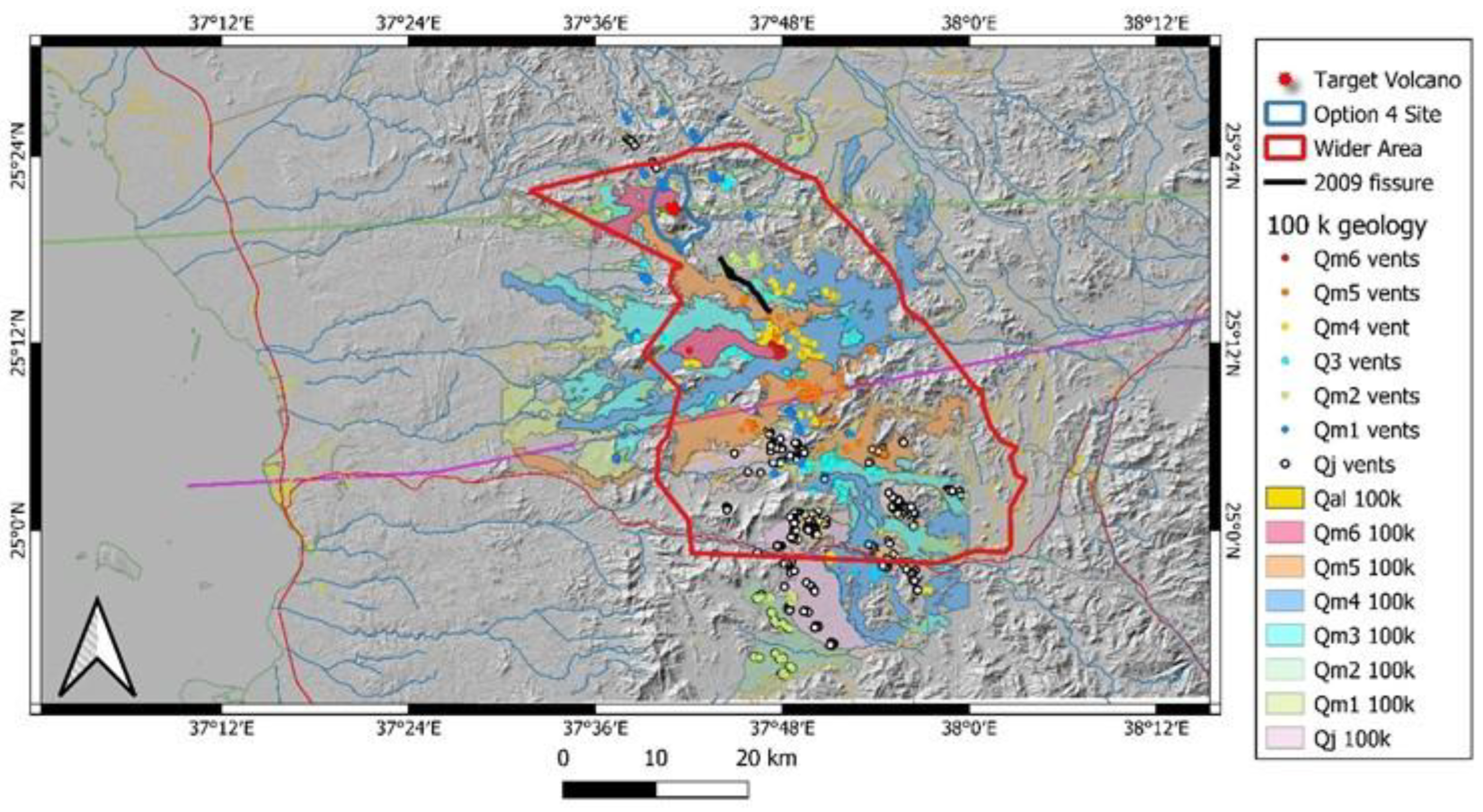
Figure 2.
Cross section across the terrain in its northern (top) southern (bottom) west (left) to the east (right) profile showing the rugged basement horst and graben structure of the region within lava flows occupied the narrow gorges. The x-axis is in kilometers while the y-axis is in meters. The red box shows the area that is within the Wider Area of Interest zone bounded by the red line in earlier maps.
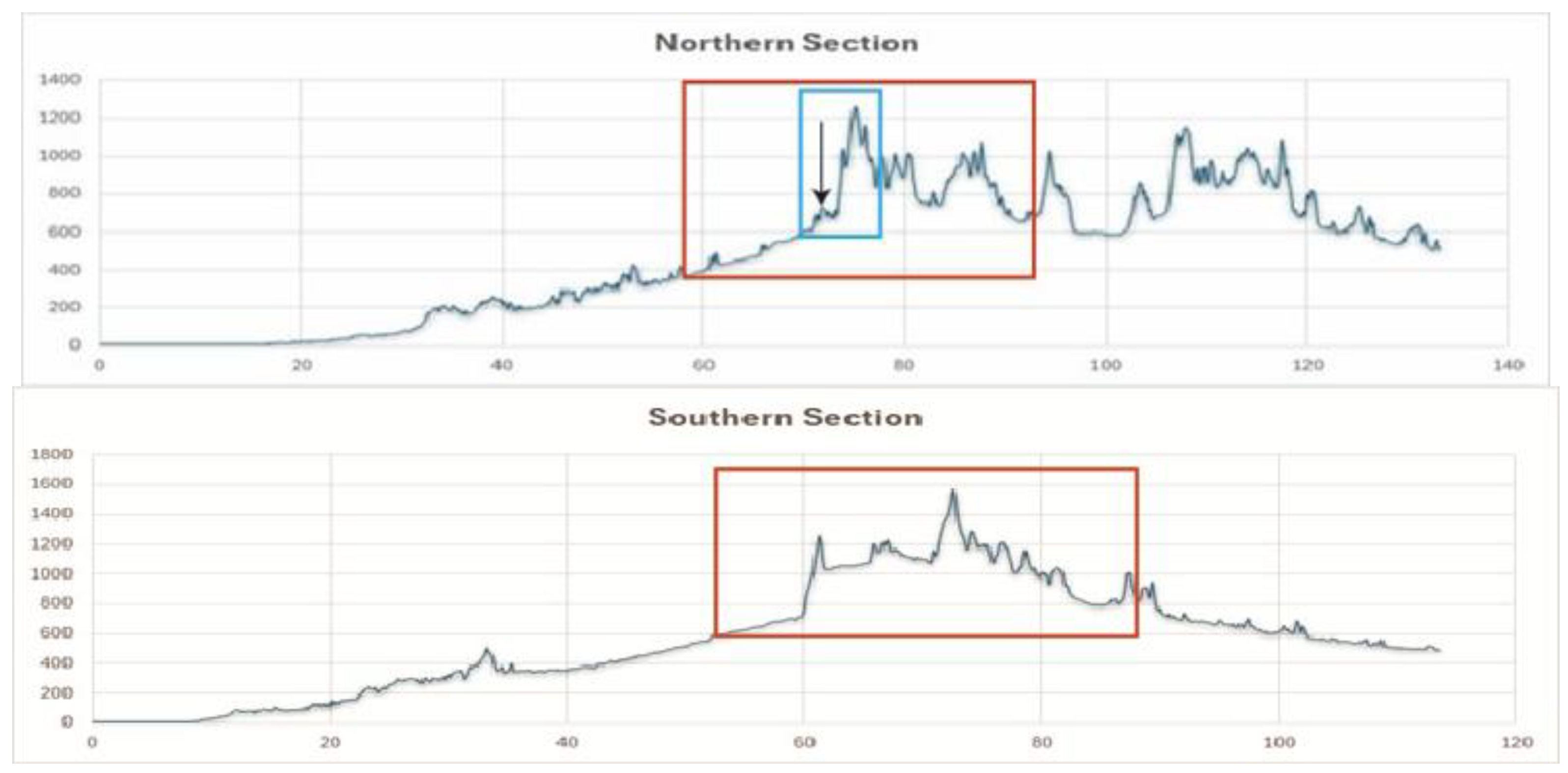
Figure 3.
Geodiversity calculation value points theoretical model to apply for various morpho-logical elements. Based on previous studies on geodiversity estimates, ruggedness turned out to be a very useful parameter that provided a very realistic geodiversity estimates hence here that value was used that then been combined with the known geo-logical features.
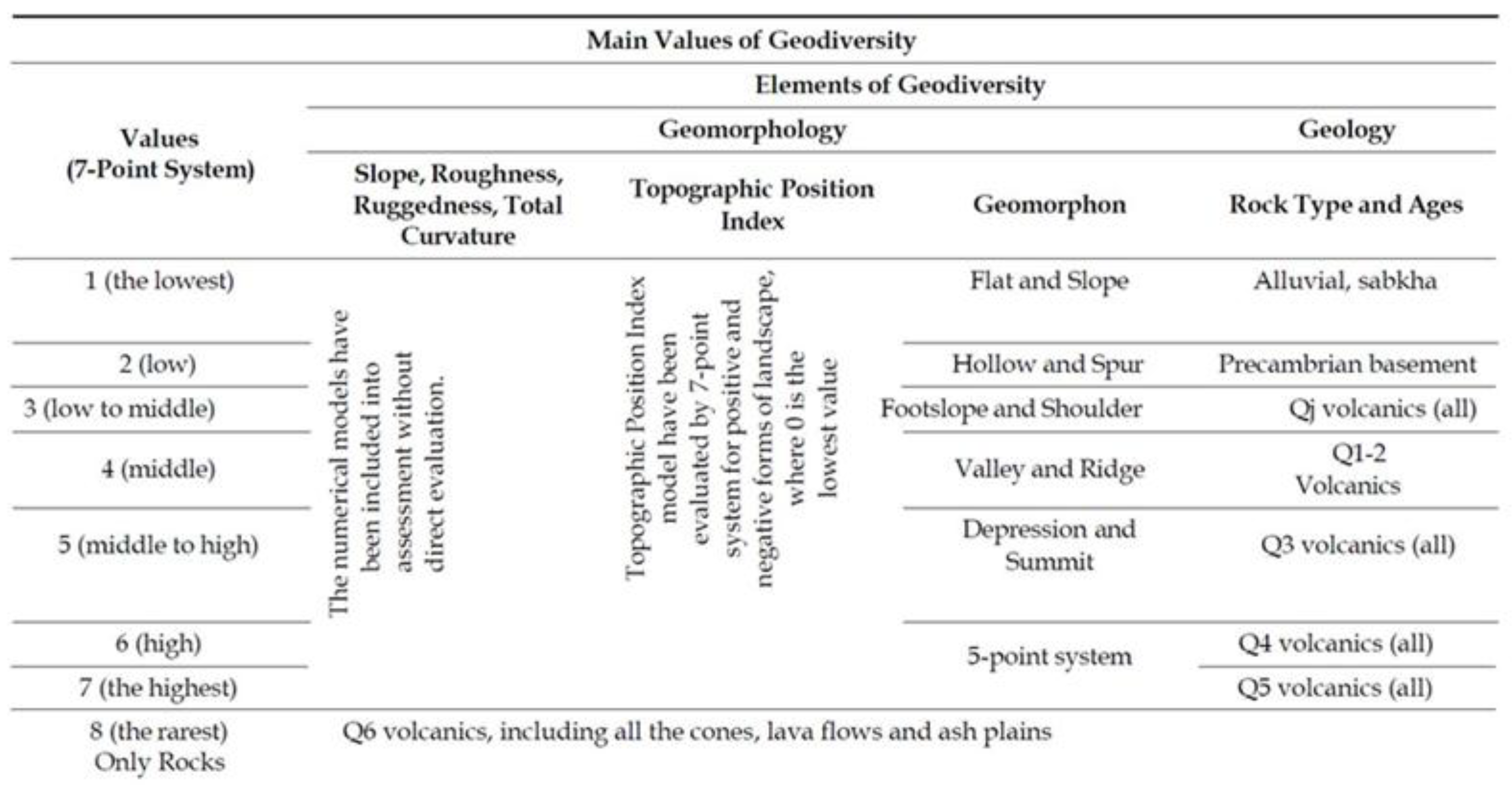
Figure 4.
Neoproterozoic basement rocks (monzogranite) form the highest peaks in the Option 4 region. They are rugged and their terrain has complex issues. However, the rock types are monotonous crystalline basement types invaded by Neoproterozoic mafic to intermediate dykes (dark cross cutting lines within the main mass). Highest peak coordinate is 25°20’39.43”N, 37°41’38.30”E.
Figure 5.
An older scoria cone with red hue on the view (Qm1) with a welded core formed by lava spattering and composed of rheomorphic lava flows within its edifice (red layers) (location of the old scoria cone in the center right view is 25°21’56.52”N, 37°40’26.69”E).
Figure 5.
An older scoria cone with red hue on the view (Qm1) with a welded core formed by lava spattering and composed of rheomorphic lava flows within its edifice (red layers) (location of the old scoria cone in the center right view is 25°21’56.52”N, 37°40’26.69”E).
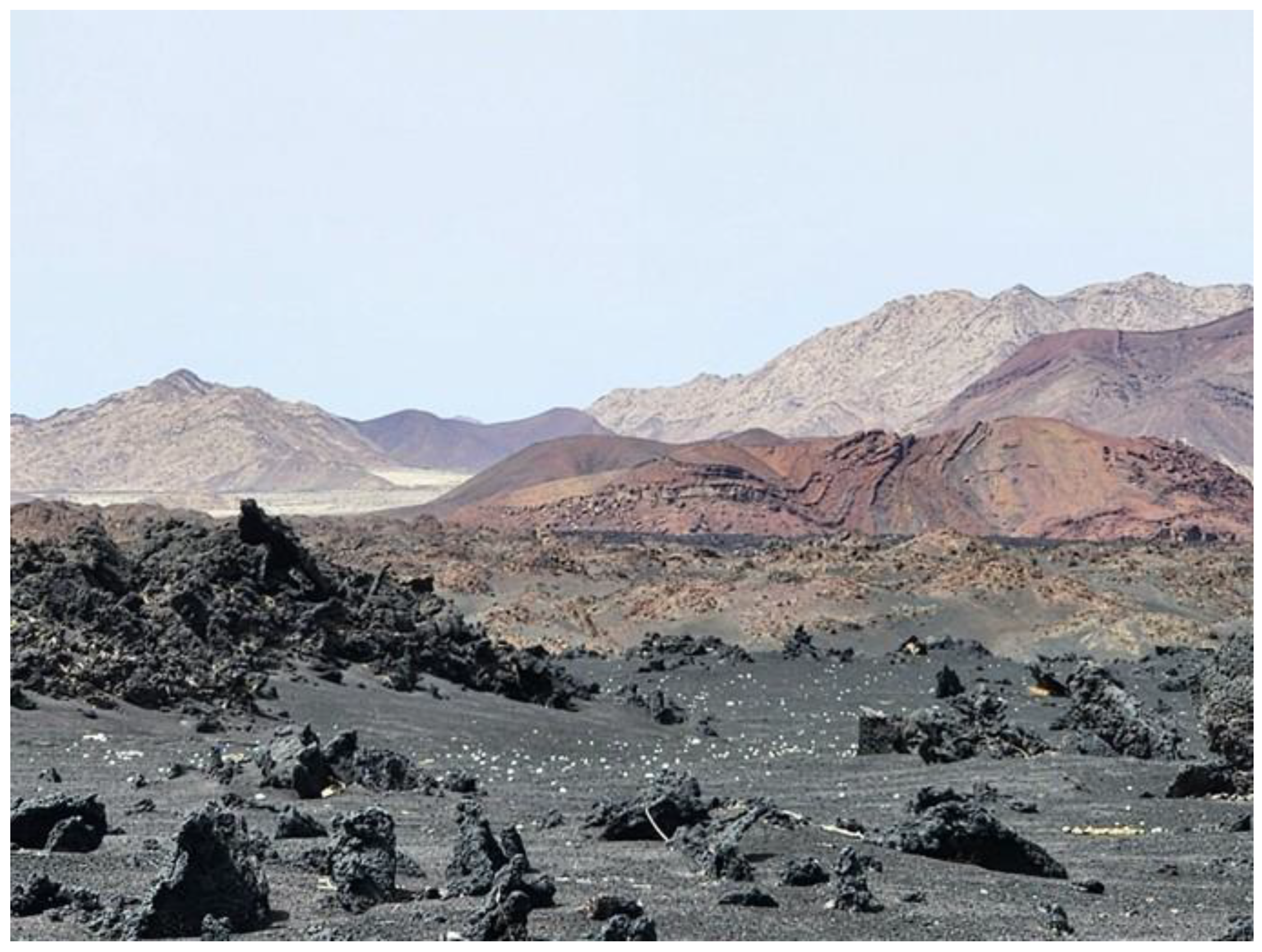
Figure 6.
Roof collapse feature of a young lava flow in the northern Harrat Lunayyir.
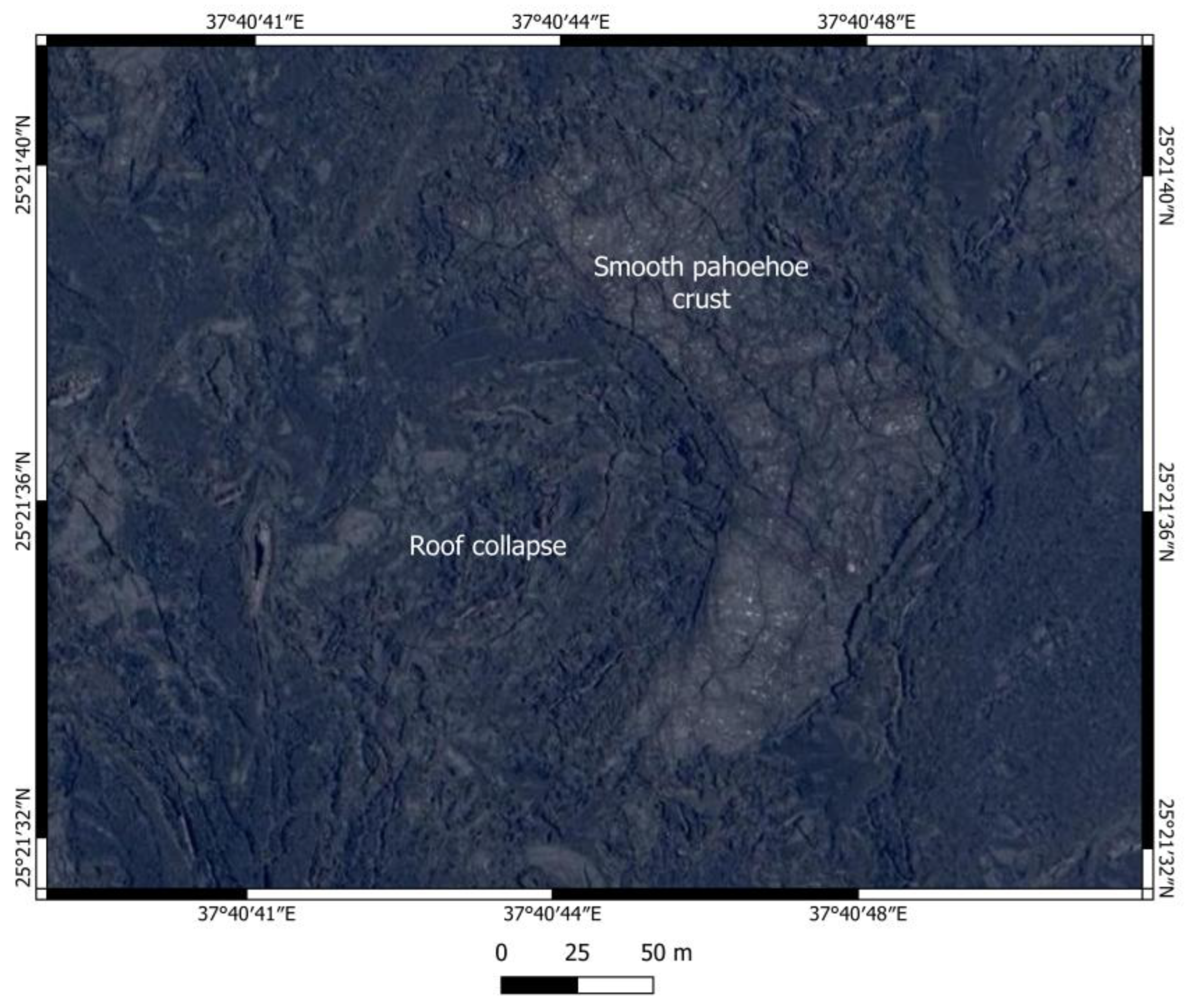
Figure 7.
Ash blanketed region in the NW side of the target volcano at the GS20 geosite (25°20’44.63”N, 37°40’38.70”E). Note the reddish ash that is oxidized scoria resulted from proximal emission hence likely marking location of localized fire pits (vents). Most of the ash is dark, bluish irisation suggesting high temperature titanium mineral formation. The area is a very fragile region, and strong restrictive rules need to be enforced as uncontrolled wondering around the ash plain not just visually damaging it but also footprints can act as erosional initiation points for next intensive rainfall or wind actions.
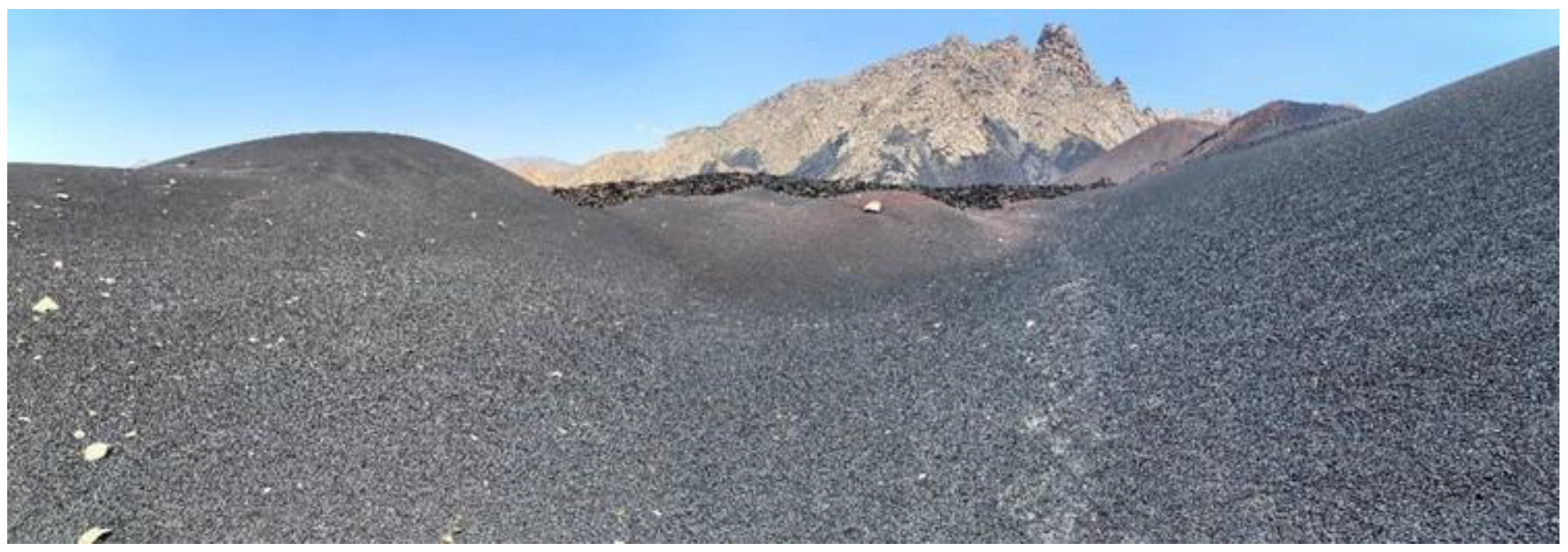
Figure 8.
Geodiversity distribution and location of the youngest lava flows in the area. Note that the area of Option 4 falls into the highest geodiversity value area and the boundary of the project site well representing the region highest valued geological sites hence the site selection should also be included in geoconservation strategy.
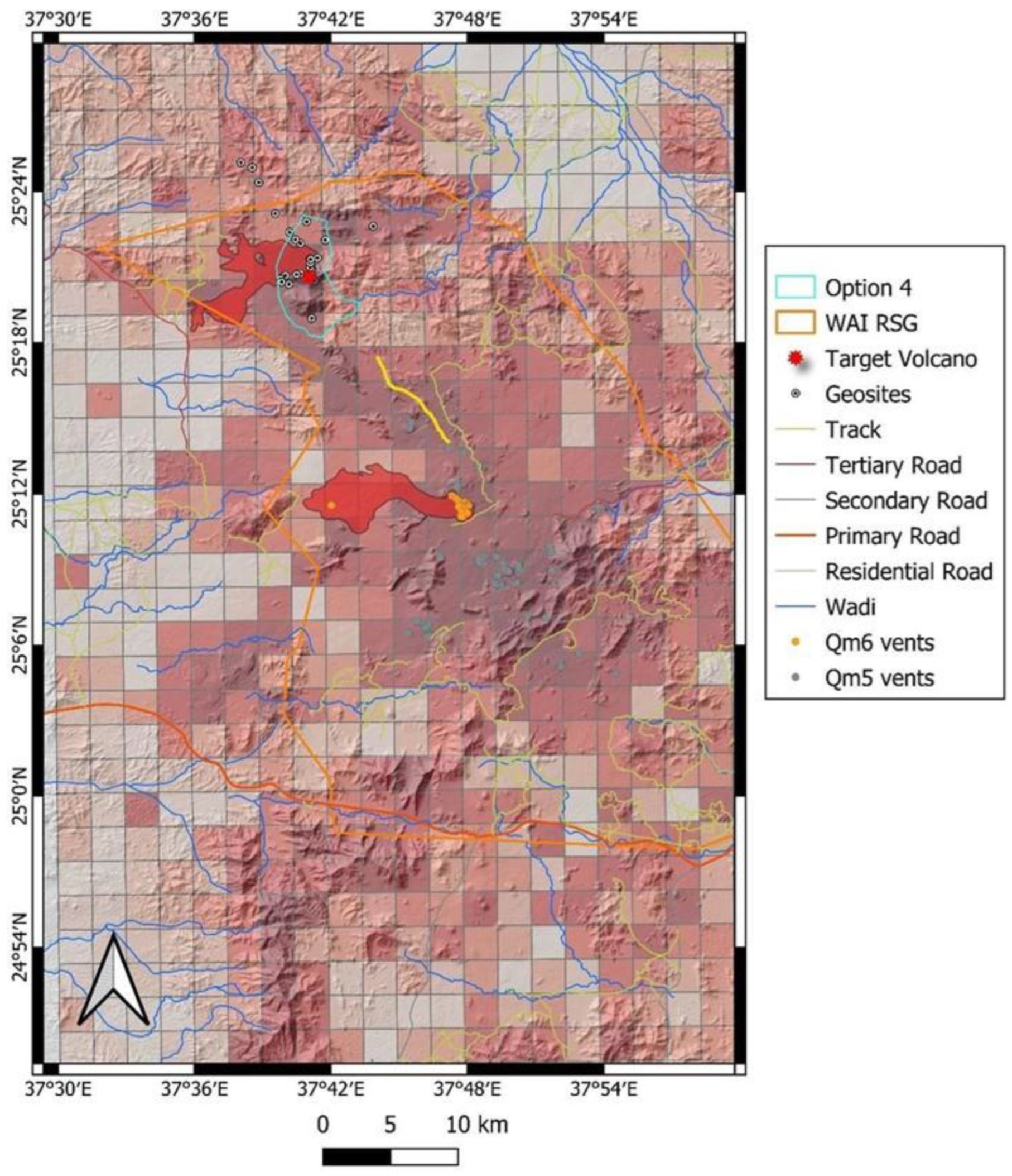
Figure 9.
Identified geosites in the northern Harrat Lunayyir. The map shows the various lava flows and vents ordered in their stratigraphy position. Where the satellite image is not covered by coloured pattern represent exposed Neoproterozoic basement rocks. Primary and remobilized Holocene volcanic ash form extensive sedimentary cover over the rugged landscape. The background is a Bing satellite image and topography enhanced by a 10-meter density contour lines derived from the ALOS-PALSAR digital elevation data.
Figure 10.
Close up view (Bing Satellite Imagery) of the Geosite 1, 2 and 3. The area is outside of the Option 4 region but as it is a confined, intact older volcanic region formed in a narrow valley beside its high aesthetic values it demonstrates clearly a geological process so typical in Harrat Lunayyir namely the narrow value-captured monogenetic volcanism. GS1 is a lookout point on top of an older scoria cone. GS2 is a Neoproterozoic dyke edge. Dykes are marked with yellow lines (only the representative ones). GS3 is an archaeological site where basement rocks formed some sort of circular feature with unknown purpose.
Figure 11.
GS1 geosite (25°25’8.61”N, 37°38’2.32”E) of an old scoria cone and associated lava flow filling the longitudinal valley. On the lava surface archaeological sites are well preserved as keyholes, and long arrows like stone arrangements.
Figure 11.
GS1 geosite (25°25’8.61”N, 37°38’2.32”E) of an old scoria cone and associated lava flow filling the longitudinal valley. On the lava surface archaeological sites are well preserved as keyholes, and long arrows like stone arrangements.
Figure 12.
Archaeological site formed by crystalline basement of Jar tonalite and Neoproterozoic dike rocks on the alluvial plain is the GS3 geosite (25°24’20.87”N, 37°38’49.57”E). Note the dykes in the background range forming edges of darker colored rocks through the tonalite.
Figure 12.
Archaeological site formed by crystalline basement of Jar tonalite and Neoproterozoic dike rocks on the alluvial plain is the GS3 geosite (25°24’20.87”N, 37°38’49.57”E). Note the dykes in the background range forming edges of darker colored rocks through the tonalite.
Figure 13.
Geosites map in the northern edge of Option 4 region. GS4 is an old scoria cone built on the steep slope of the basement due to lava spattering while GS7 and GS8 are part of similar scoria cones formed on flat surface. GS5 and GS10 are lava flow features. GS5 is a typical high stand marker of preserved lava representing the highest level of lava inundation prior lava drained the region while GS10 is a typical pāhoehoe lava flow edge of the youngest flow of the region. GS9 is a complex sedimentary environment where aeolian, alluvial and sabkha deposits mixed with fine ash.

Figure 14.
GS4 geosite (25°23’14.52”N, 37°39’33.16”E) is a spectacular scoria cone (dark draping rocks over light color basement rocks) from the Qm1 stage that erupted on a steep probably fault-bounded terrain. Basement rocks of Jar tonalite (light) crops out from the gradually stripped scoria surface. The background of the ridge is composed of slightly more mafic tonalite.
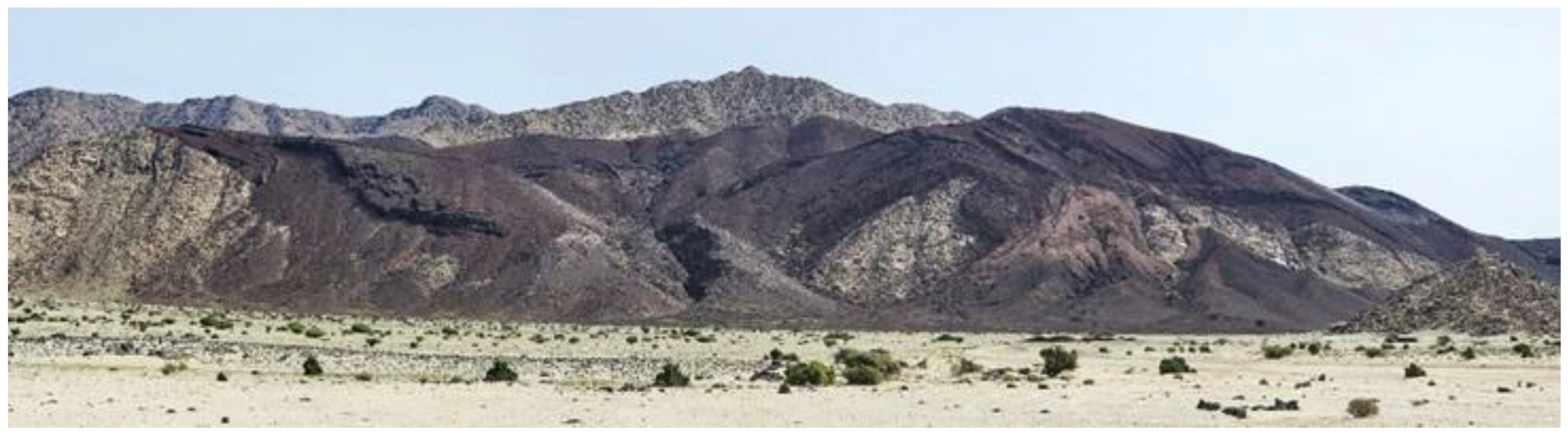
Figure 15.
GS7 (25°22’23.06”N, 37°40’7.01”E) is a Qm1 stage scoria cone where gully network developed indicating its formation prior to major pluvial periods. The cone is conical shape, but its crater is clearly preserved by spatter ramparts and the outer flanks are already erosionally modified. Note the Target Volcano slightly reddish cone in front of the basement crystalline rock cliffs partially covered by ash.
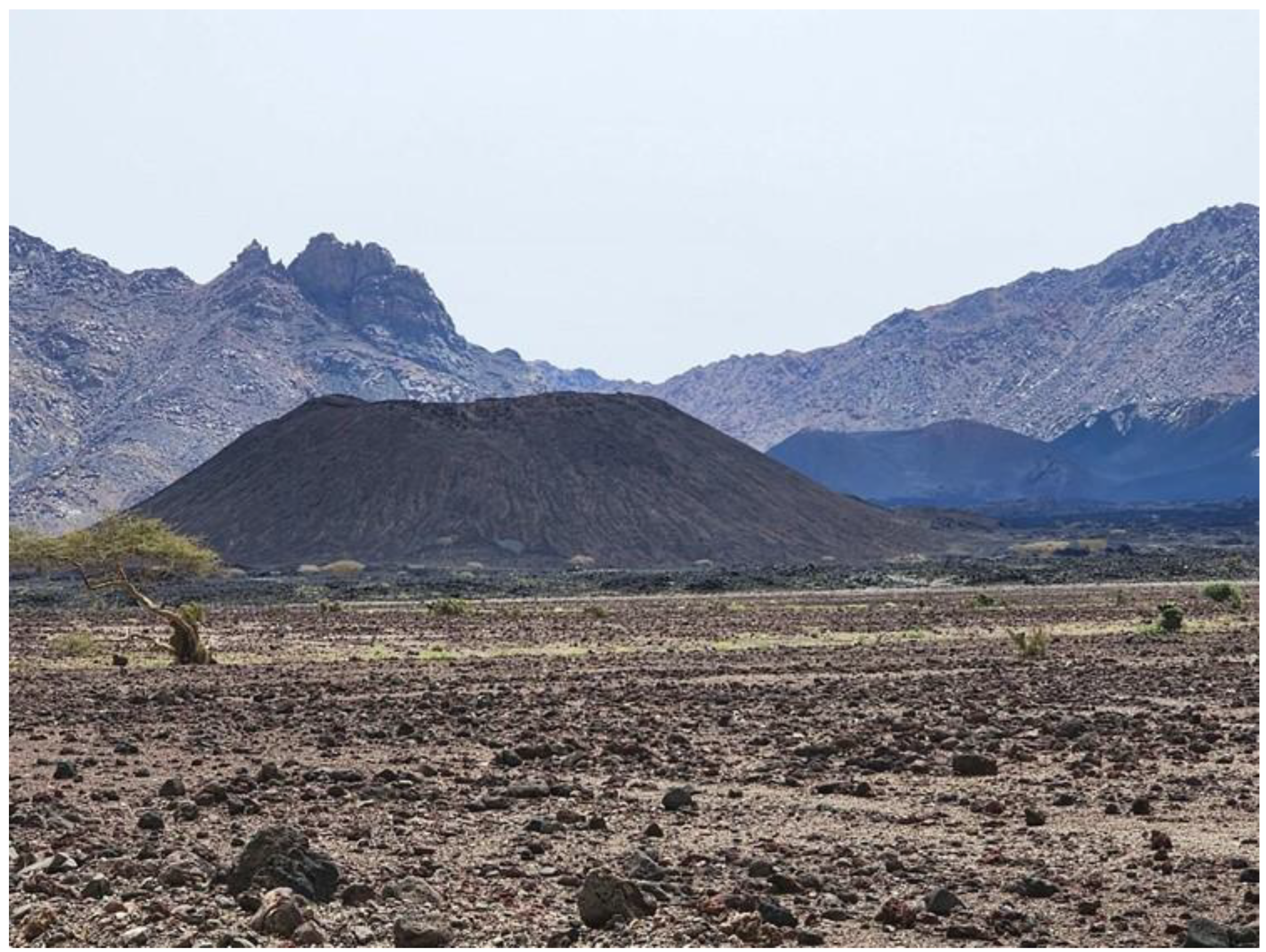
Figure 16.
GS6 geosite (25°22’29.84”N, 37°44’0.93”E) is the most representative location of a very complex scoria cone complex that is outside the Option 4 territory. It is an active quarry where quarry walls perfectly exposing the proximal sections of compound scoria cones formed over long time and very likely in different evolutions stages. The volcanic complex formed in the juxtaposed location of three types of basement rocks. In the SW edge of the region Jar tonalite, in the northern and eastern side of the volcanic complex Fara’ trondhjemite forming the exposed basement rocks surrounding the volcanic complex.
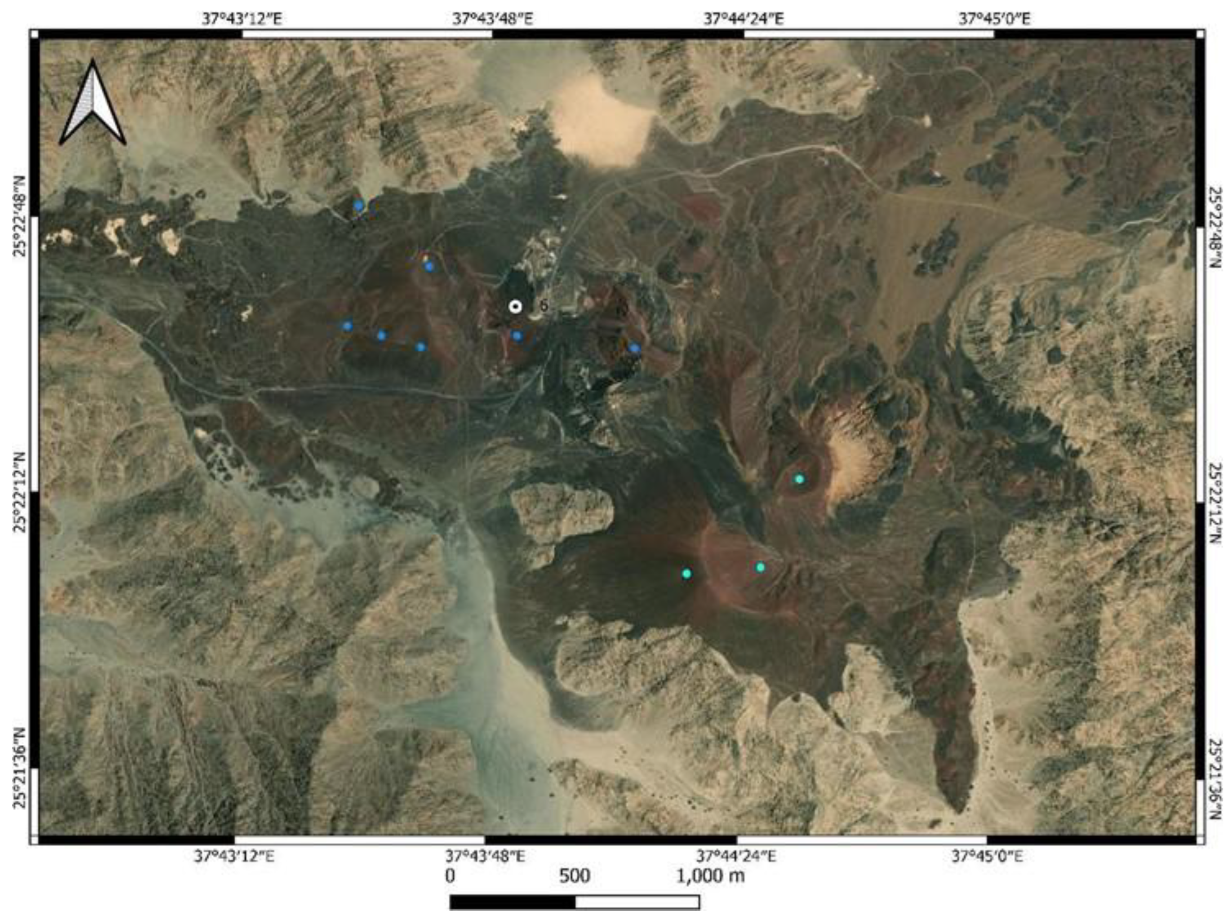
Figure 17.
Volcanic complex of amalgamated scoria cones GS6 (25°22’29.84”N, 37°44’0.93”E) from the west filling the morphological depression within the basement horst. The light color rocks of the ridge in the left side of the view part of the mafic Jar tonalite.
Figure 17.
Volcanic complex of amalgamated scoria cones GS6 (25°22’29.84”N, 37°44’0.93”E) from the west filling the morphological depression within the basement horst. The light color rocks of the ridge in the left side of the view part of the mafic Jar tonalite.
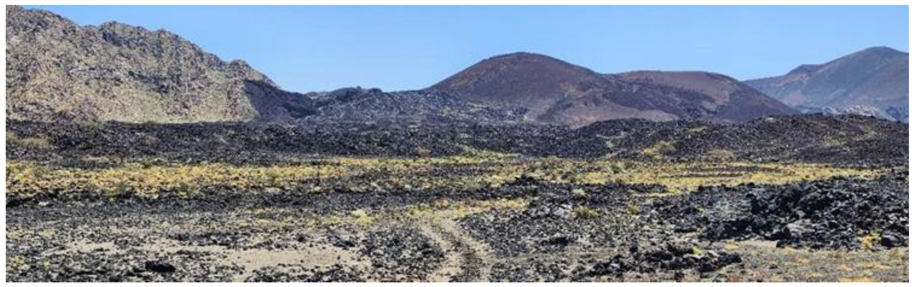
Figure 18.
Overview geological sketch map based on Bing satellite imagery from the center area of the Option 4 region. This area records volcanic features associated with the scoria cone growth, its explosive and effusive as well as collapsing stages. These geosites are very fragile and proper geoconservation strategies are recommended to be developed to keep the integrity of the area intact. The image also demonstrates that the Target Volcano is a complex and potentially active (weeks to month) volcano judging from its size and complex crater morphology. Narrow ridges along its crater indicate gradual step-like collapses toward NW. Each of the collapses or gradual spreading inferred to be the result of lava flow emission from the crater toward the NW letting the crater floor sink, and through explosive phases reheel. The latest lava flow came from the crater is not covered by ash (marked as post-sub-Plinian rubbly pāhoehoe), while in the western areas aa-type lava covered with ash. This indicates that the volcano went through stages of eruptions when explosive phases accompanied with lava flow emission that lasted well after the explosive phases resumed leaving behind a complex flow channel network within the main Q,6 lava flow field.
Figure 19.
The eastern side of the Target Volcano represents a typical intramountain basin at GS19 (25°20’27.72”N, 37°41’16.09”E) where primary ash and lapilli accumulated and partially reworked due to sheet wash erosion. The eastern side of the Target Volcano is surrounded by a monzogranite, syenogranite complex (light color rocks in the background). This basement ridge was partially blanketed by dark scoriaceous ash that gradually stripped away since the volcanism ceased. This geosite is a very fragile region and restricted access is recommended, as footprints and tire tracks can damage the integrity of the area.
Figure 20.
Another view of the GS21 (25°20’43.93”N, 37°40’26.06”E) with a fantastic squeeze up feature on the aa lava margin. In the background the monzogranite basement horst that is partially covered by ash is clearly visible. Note the reddish ash regions marking localized, short lived vents emitted ash during the explosive phase of the volcano growth.
Figure 21.
The most remote side of the Option 4 area exhibit a complex region where older Qm2 volcanoes partially covered by ash (black areas) derived from the region of the Target Volcano (Qm6) and the two youngest flow field (Qm5 – light brown field - and Qm6 – light green field) meet. The identified geosites are very important messengers of the geological history hence their preservation is very important for future research. Blue line represent the Option 4 development area western margin.
Figure 22.
Ash covered gullies at GS22 (25°20’40.90”N, 37°39’59.23”E). Note the ash cover on the aa lava margin, indicating that the following the ash emission, lava flow outpouring was still ongoing.
Figure 22.
Ash covered gullies at GS22 (25°20’40.90”N, 37°39’59.23”E). Note the ash cover on the aa lava margin, indicating that the following the ash emission, lava flow outpouring was still ongoing.
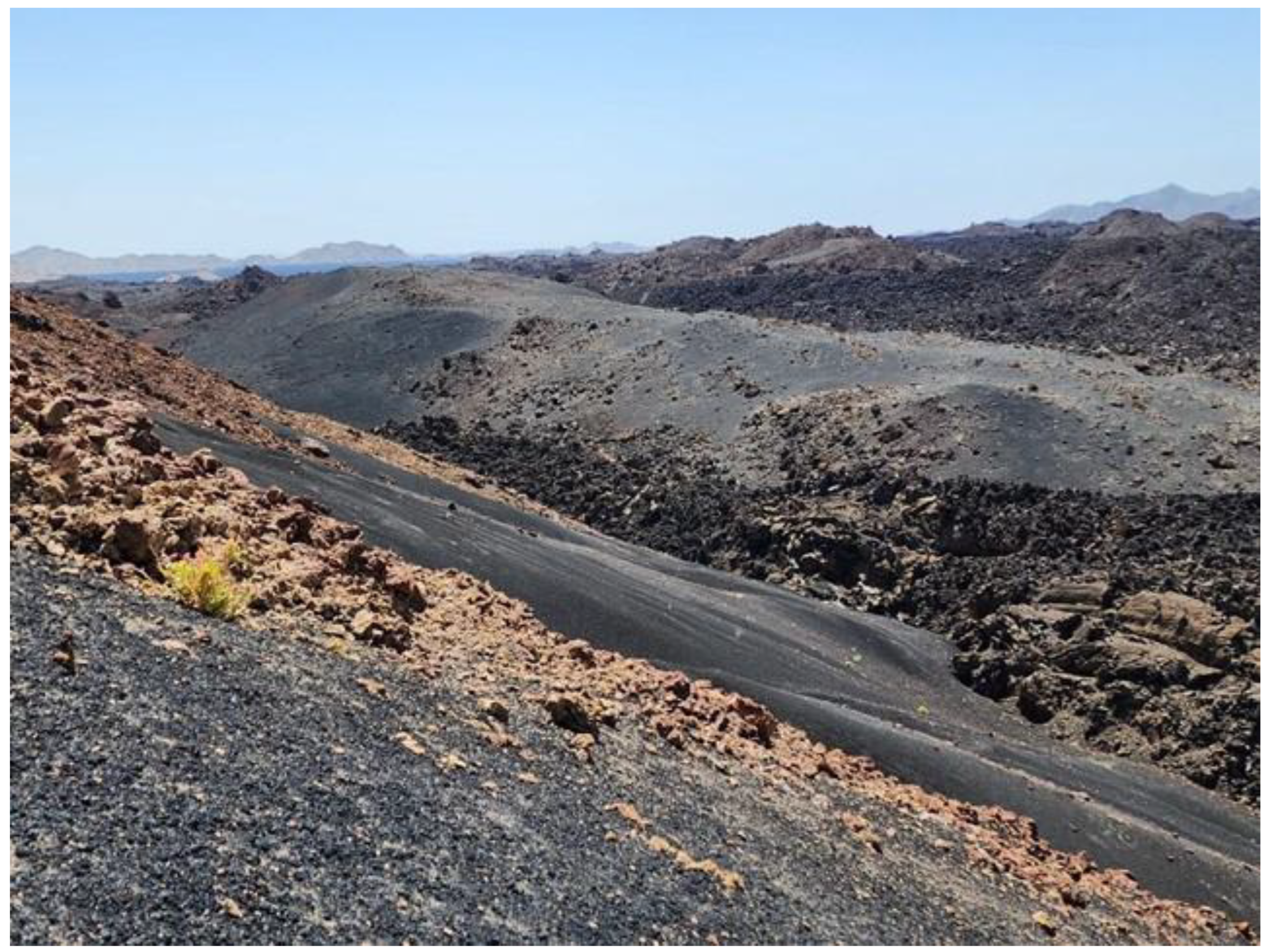

Table 1.
Geosite inventory for the Option 4 area: Significance is assessed as local, regional, or global. Local sites are unique within the area but common regionally, regional sites are rare in the region with notable preservation or appearance, and global sites are considered reference points or unique features on a worldwide scale. Bold, underlined geosites in a cream color rows are locations where volcanic geoheritage of the Quaternary volcanic field is exceptionally well preserved and demonstrated.
| Geosite code | Lat | Long | Description | Significance |
| GS1 | 25°25’8.61”N | 37°38’2.32”E | Eroded scoria cone and associated lava field. Lava surface has archaeology sites. | Local but archaeology sites can be global |
| GS2 | 25°24’56.29”N | 37°38’31.62”E | Dark massive dyke in meters wide crosscutting the light coloured tonalite crystalline rocks | Local to Regional |
| GS3 | 25°24’20.87”N | 37°38’49.57”E | Archaeological site made from dyke fragments derived from a nearby mafic to intermediate dyke. | Regional to Global |
| GS4 | 25°23’14.52”N | 37°39’33.16”E | Welded scoria core and agglutinate preserved on steep basement horst, potentially along a fault. | Regional |
| GS5 | 25°22’47.30”N | 37°40’54.37”E | Former lava flow level mark. | Local to Regional |
| GS6 | 25°22’29.84”N | 37°44’0.93”E | Quarried scoria cone with extensive ash and lapilli beds, perfect exposures to see the internal architecture of scoria cone complexes. | Regional |
| GS7 | 25°22’23.06”N | 37°40’7.01”E | Qm1 stage scoria cone in well-preserved condition with ash cover | Regional |
| GS8 | 25°21’58.45”N | 37°40’26.68”E | Agglomerate proximal scoria cone core and open crater that is accessible. Lee side ash accumulation in wind shadows. | Regional |
| GS9 | 25°21’56.03”N | 37°41’36.63”E | Sabkha deposit, silt pan | Local |
| GS10 | 25°21’53.55”N | 37°40’41.22”E | Pahoehoe lava flow margin with inflation and deflation features | Local |
| GS11 | 25°21’19.98”N | 37°41’5.08”E | Spectacular slabby pāhoehoe lava surface texture | Regional to Global |
| GS12 | 25°21’22.03”N | 37°41’24.14”E | Complex volcaniclastic fan deposit with recent gravity flows and rock falls. | Regional to Global |
| GS13 | 25°21’18.34”N, | , 37°41’5.31”E | Monzogranite as a main rock type of the high ranges behind the Target Volcano | Local |
| GS14 | 25°21’10.99”N | 37°41’7.24”E | Flow lobe tumuli | Local to Regional |
| GS15 | 25°21’0.52”N | 37°41’5.20”E | Slabby pāhoehoe lava flow margin | Local to Regional |
| GS16 | 25°20’54.72”N | 37°41’9.32” | Scoriaceous ash and lapilli-dominated fan | Regional |
| GS17 | 25°20’46.31”N | 37°41’8.23”E | Ballistic bomb field | Regional to Global |
| GS18 | 25°20’35.74”N | 37°41’6.55” | Complex crater of the youngest volcano in the region | Regional to Global |
| GS19 | 25°20’27.72”N | 37°41’16.09”E | Small intramountain basin with complex volcaniclastic sedimentary infill | Regional to Global |
| GS20 | 25°20’44.63”N | 37°40’38.70”E | Ash plain covering the landscape | Regional |
| GS21 | 25°20’43.93”N | 37°40’26.06”E | Partially ash-covered aa lava flow | Regional |
| GS22 | 25°20’40.90”N | 37°39’59.23”E | Series of gullies covered by primary volcanic ash and lapilli | Regional |
| GS23 | 25°20’32.28”N | 37°39’46.08”E | Preserved primary ash fall in thick successions | Regional |
| GS24 | 25°20’23.59”N | 37°39’48.18”E | Convulsion of various lava flows entering an open crater old scoria cone | Regional |
| GS25 | 25°20’20.92”N | 37°40’12.24”E | Complex volcaniclastic sedimentary fan | Regional |
| GS26 | 25°19’2.88”N | 37°41’33.06”E | Ash starved alluvial fan in a closed basin | Local |
Table 2.
Scientific value matrix of the identified geosites in the region around the area of Option 4. Each category was assigned with 1, 2 or 4 points, representing the geosite values. The greater the value the higher the poinst were as. Weight classes to calculate the overall value of the geosite listed in the left side of the table.
| Scientific Values | Weigth | Geosites | Representativeness | Key Locality | Scientific knowledge | Integrity | Geological diversity | Rarity | Use limitations | Total Weighted |
| Representativeness | 30 | GS1 | 2 | 1 | 1 | 4 | 2 | 1 | 4 | 2,1 |
| Key Locality | 20 | GS2 | 2 | 1 | 1 | 4 | 1 | 1 | 4 | 2,05 |
| Scientific knowledge | 5 | GS3 | 2 | 1 | 1 | 4 | 1 | 2 | 4 | 2,2 |
| Integrity | 15 | GS4 | 4 | 1 | 1 | 4 | 4 | 4 | 4 | 3,25 |
| Geological diversity | 5 | GS5 | 2 | 1 | 1 | 4 | 1 | 2 | 4 | 2,2 |
| Rarity | 15 | GS6 | 4 | 1 | 1 | 2 | 4 | 2 | 4 | 2,65 |
| Use limitations | 10 | GS7 | 2 | 1 | 1 | 4 | 4 | 2 | 4 | 2,35 |
| Total | 100 | GS8 | 2 | 1 | 1 | 4 | 2 | 2 | 4 | 2,25 |
| GS9 | 2 | 1 | 1 | 2 | 1 | 1 | 4 | 1,75 | ||
| GS10 | 2 | 1 | 1 | 4 | 2 | 1 | 4 | 2,1 | ||
| GS11 | 2 | 1 | 1 | 4 | 1 | 2 | 4 | 2,2 | ||
| GS12 | 4 | 1 | 1 | 4 | 2 | 2 | 4 | 2,85 | ||
| GS13 | 2 | 1 | 1 | 4 | 1 | 1 | 4 | 2,05 | ||
| GS14 | 2 | 1 | 1 | 4 | 1 | 1 | 4 | 2,05 | ||
| GS15 | 2 | 1 | 1 | 4 | 1 | 1 | 4 | 2,05 | ||
| GS16 | 4 | 1 | 1 | 4 | 2 | 4 | 4 | 3,15 | ||
| GS17 | 4 | 1 | 1 | 4 | 2 | 4 | 4 | 3,15 | ||
| GS18 | 4 | 1 | 1 | 4 | 4 | 2 | 4 | 2,95 | ||
| GS19 | 4 | 1 | 1 | 4 | 4 | 2 | 4 | 2,95 | ||
| GS20 | 4 | 1 | 1 | 4 | 2 | 4 | 4 | 3,15 | ||
| GS21 | 4 | 1 | 1 | 4 | 2 | 2 | 4 | 2,85 | ||
| GS22 | 2 | 1 | 1 | 4 | 2 | 2 | 4 | 2,25 | ||
| GS23 | 4 | 1 | 1 | 4 | 2 | 4 | 4 | 3,15 | ||
| GS24 | 4 | 1 | 1 | 4 | 4 | 2 | 4 | 2,95 | ||
| GS25 | 4 | 1 | 1 | 4 | 2 | 2 | 4 | 2,85 | ||
| GS26 | 2 | 1 | 1 | 4 | 2 | 1 | 4 | 2,1 |
Table 3.
Potential Touristic Use (PTU) matrix of the geosites in the region around the area of Option 4. The PTU values are also calculated at 1.2, and 4 points represent the location increasing values. The wight values for the total PTU calculation are given on the left side of the table.
Table 3.
Potential Touristic Use (PTU) matrix of the geosites in the region around the area of Option 4. The PTU values are also calculated at 1.2, and 4 points represent the location increasing values. The wight values for the total PTU calculation are given on the left side of the table.
| PTU | Weigth | Geosites | Vulnerability | Accessibility | Use limitations | Safety | Logistics |
Density population |
Association with other values |
Scenery | Uniqueness |
Observation conditions |
Interpretative potential |
Economic level | Proximity to recreational areas | Total weighted |
| Vulnerability | 10 | GS1 | 4 | 1 | 4 | 1 | 2 | 1 | 4 | 2 | 2 | 4 | 4 | 1 | 1 | 2,35 |
| Accessibility | 10 | GS2 | 4 | 1 | 4 | 1 | 2 | 1 | 4 | 2 | 2 | 4 | 4 | 1 | 1 | 2,35 |
| Use limitations | 5 | GS3 | 3 | 1 | 4 | 1 | 2 | 1 | 4 | 3 | 4 | 4 | 4 | 1 | 1 | 2,6 |
| Safety | 10 | GS4 | 4 | 1 | 4 | 1 | 2 | 1 | 3 | 4 | 4 | 4 | 4 | 1 | 1 | 2,8 |
| Logistics | 5 | GS5 | 2 | 1 | 4 | 1 | 2 | 1 | 2 | 1 | 3 | 4 | 4 | 1 | 1 | 2 |
| Density population | 5 | GS6 | 1 | 1 | 4 | 1 | 2 | 1 | 4 | 2 | 3 | 2 | 4 | 1 | 1 | 2,05 |
| Other values | 5 | GS7 | 4 | 1 | 4 | 1 | 2 | 1 | 4 | 4 | 2 | 4 | 4 | 1 | 1 | 2,65 |
| Scenery | 15 | GS8 | 3 | 1 | 4 | 1 | 2 | 1 | 2 | 3 | 3 | 4 | 4 | 1 | 1 | 2,4 |
| Uniqueness | 10 | GS9 | 1 | 1 | 4 | 1 | 2 | 1 | 2 | 1 | 1 | 2 | 2 | 1 | 1 | 1,4 |
| Observation conditions | 5 | GS10 | 3 | 1 | 4 | 1 | 2 | 1 | 2 | 3 | 2 | 4 | 4 | 1 | 1 | 2,3 |
| Interpretative potential | 10 | GS11 | 2 | 1 | 4 | 1 | 2 | 1 | 2 | 2 | 4 | 4 | 4 | 1 | 1 | 2,25 |
| Economic level | 5 | GS12 | 1 | 1 | 4 | 1 | 2 | 1 | 4 | 4 | 3 | 4 | 4 | 1 | 1 | 2,45 |
| Proximity to recreational areas | 5 | GS13 | 3 | 1 | 4 | 1 | 2 | 1 | 4 | 3 | 1 | 4 | 3 | 1 | 1 | 2,2 |
| Total | 100 | GS14 | 3 | 1 | 4 | 1 | 2 | 1 | 3 | 3 | 3 | 4 | 4 | 1 | 1 | 2,45 |
| GS15 | 3 | 1 | 4 | 1 | 2 | 1 | 3 | 3 | 3 | 4 | 4 | 1 | 1 | 2,45 | ||
| GS16 | 3 | 1 | 4 | 1 | 2 | 1 | 3 | 2 | 3 | 4 | 4 | 1 | 1 | 2,3 | ||
| GS17 | 1 | 1 | 4 | 1 | 2 | 1 | 3 | 3 | 4 | 4 | 4 | 1 | 1 | 2,35 | ||
| GS18 | 3 | 1 | 4 | 1 | 2 | 1 | 4 | 4 | 2 | 4 | 4 | 1 | 1 | 2,55 | ||
| GS19 | 2 | 1 | 4 | 1 | 2 | 1 | 4 | 3 | 2 | 4 | 4 | 1 | 1 | 2,3 | ||
| GS20 | 1 | 1 | 4 | 1 | 2 | 1 | 3 | 3 | 4 | 4 | 4 | 1 | 1 | 2,35 | ||
| GS21 | 3 | 1 | 4 | 1 | 2 | 1 | 3 | 3 | 3 | 4 | 4 | 1 | 1 | 2,45 | ||
| GS22 | 3 | 1 | 4 | 1 | 2 | 1 | 2 | 3 | 3 | 4 | 4 | 1 | 1 | 2,4 | ||
| GS23 | 1 | 1 | 4 | 1 | 2 | 1 | 2 | 2 | 3 | 4 | 4 | 1 | 1 | 2,05 | ||
| GS24 | 4 | 1 | 4 | 1 | 2 | 1 | 4 | 4 | 3 | 4 | 4 | 1 | 1 | 2,75 | ||
| GS25 | 2 | 1 | 4 | 1 | 2 | 1 | 3 | 4 | 2 | 4 | 4 | 1 | 1 | 2,4 | ||
| GS26 | 2 | 1 | 4 | 1 | 2 | 1 | 2 | 3 | 1 | 4 | 3 | 1 | 1 | 2 |
Table 4.
Potential Education Use (PEU) matrix of the geosites in the region around the area of Option 4. The PEU values are also calculated at 1.2, and 4 points represent the location increasing values. The wight values for the total PEU calculation are given on the left side of the table.
Table 4.
Potential Education Use (PEU) matrix of the geosites in the region around the area of Option 4. The PEU values are also calculated at 1.2, and 4 points represent the location increasing values. The wight values for the total PEU calculation are given on the left side of the table.
| PEU | Weight | Geosites | Vulnerability | Accessibility | Use limitations | Safety | Logistics | Density population | Association with other values | Scenery | Uniqueness | Observation conditions | Didactive potential | Geological potential | Total weigthed |
| Vulnerability | 10 | GS1 | 4 | 1 | 4 | 1 | 2 | 1 | 4 | 2 | 2 | 4 | 2 | 3 | 2,45 |
| Accessibility | 10 | GS2 | 4 | 1 | 4 | 1 | 2 | 1 | 4 | 2 | 2 | 4 | 2 | 3 | 2,45 |
| Use limitations | 5 | GS3 | 3 | 1 | 4 | 1 | 2 | 1 | 4 | 3 | 4 | 4 | 2 | 1 | 2,3 |
| Safety | 10 | GS4 | 4 | 1 | 4 | 1 | 2 | 1 | 3 | 4 | 4 | 4 | 2 | 3 | 2,6 |
| Logistics | 5 | GS5 | 2 | 1 | 4 | 1 | 2 | 1 | 2 | 1 | 3 | 4 | 2 | 1 | 1,95 |
| Density population | 5 | GS6 | 1 | 1 | 4 | 1 | 2 | 1 | 4 | 2 | 3 | 2 | 2 | 4 | 2,1 |
| Other values | 5 | GS7 | 4 | 1 | 4 | 1 | 2 | 1 | 4 | 4 | 2 | 4 | 2 | 3 | 2,55 |
| Scenery | 5 | GS8 | 3 | 1 | 4 | 1 | 2 | 1 | 2 | 3 | 3 | 4 | 2 | 1 | 2,15 |
| Uniqueness | 5 | GS9 | 1 | 1 | 4 | 1 | 2 | 1 | 2 | 1 | 1 | 2 | 2 | 1 | 1,55 |
| Observation conditions | 10 | GS10 | 3 | 1 | 4 | 1 | 2 | 1 | 2 | 3 | 2 | 4 | 2 | 2 | 2,2 |
| Didactic potential | 20 | GS11 | 2 | 1 | 4 | 1 | 2 | 1 | 2 | 2 | 4 | 4 | 2 | 1 | 2,05 |
| Geological potential | 10 | GS12 | 1 | 1 | 4 | 1 | 2 | 1 | 4 | 4 | 3 | 4 | 2 | 4 | 2,4 |
| Total | 100 | GS13 | 3 | 1 | 4 | 1 | 2 | 1 | 4 | 3 | 1 | 4 | 2 | 2 | 2,25 |
| GS14 | 3 | 1 | 4 | 1 | 2 | 1 | 3 | 3 | 3 | 4 | 2 | 1 | 2,2 | ||
| GS15 | 3 | 1 | 4 | 1 | 2 | 1 | 3 | 3 | 3 | 4 | 2 | 2 | 2,3 | ||
| GS16 | 3 | 1 | 4 | 1 | 2 | 1 | 3 | 2 | 3 | 4 | 2 | 2 | 2,25 | ||
| GS17 | 1 | 1 | 4 | 1 | 2 | 1 | 3 | 3 | 4 | 4 | 2 | 2 | 2,15 | ||
| GS18 | 3 | 1 | 4 | 1 | 2 | 1 | 4 | 4 | 2 | 4 | 2 | 3 | 2,45 | ||
| GS19 | 2 | 1 | 4 | 1 | 2 | 1 | 4 | 3 | 2 | 4 | 2 | 3 | 2,3 | ||
| GS20 | 1 | 1 | 4 | 1 | 2 | 1 | 3 | 3 | 4 | 4 | 2 | 2 | 2,15 | ||
| GS21 | 3 | 1 | 4 | 1 | 2 | 1 | 3 | 3 | 3 | 4 | 2 | 1 | 2,2 | ||
| GS22 | 3 | 1 | 4 | 1 | 2 | 1 | 2 | 3 | 3 | 4 | 2 | 2 | 2,25 | ||
| GS23 | 1 | 1 | 4 | 1 | 2 | 1 | 2 | 2 | 3 | 4 | 2 | 1 | 1,9 | ||
| GS24 | 4 | 1 | 4 | 1 | 2 | 1 | 4 | 4 | 3 | 4 | 2 | 4 | 2,7 | ||
| GS25 | 2 | 1 | 4 | 1 | 2 | 1 | 3 | 4 | 2 | 4 | 2 | 2 | 2,2 | ||
| GS26 | 2 | 1 | 4 | 1 | 2 | 1 | 2 | 3 | 1 | 4 | 2 | 2 | 2,05 |
Table 5.
Degradation risk (DR) estimates comparative matrix of the identified geosites in the region around the area of Option 4. The DR values are also calculated at 1.2, and 4 points represent the location increasing values. The wight values for the total PTU calculation are given on the left side of the table.
| Degradation Risk | Weigth | Geosites | Deterioration of geological elements | Proximity to areas/activities with potential to cause degradation | Legal protection | Accessibility | Density of population | Total weighted |
| Deterioration of geological elements | 35 | GS1 | 1 | 2 | 4 | 2 | 1 | 1,95 |
| Proximity to areas/activities with potential to cause degradation | 20 | GS2 | 2 | 3 | 4 | 2 | 1 | 2,5 |
| Legal protection | 20 | GS3 | 3 | 3 | 4 | 1 | 1 | 2,7 |
| Accessibility | 15 | GS4 | 1 | 1 | 4 | 1 | 1 | 1,6 |
| Density of population | 10 | GS5 | 2 | 2 | 4 | 2 | 1 | 2,3 |
| Total | 100 | GS6 | 3 | 4 | 4 | 2 | 1 | 3,05 |
| GS7 | 1 | 1 | 4 | 1 | 1 | 1,6 | ||
| GS8 | 1 | 1 | 4 | 1 | 1 | 1,6 | ||
| GS9 | 3 | 3 | 4 | 2 | 1 | 2,85 | ||
| GS10 | 2 | 2 | 4 | 1 | 1 | 2,15 | ||
| GS11 | 2 | 2 | 4 | 1 | 1 | 2,15 | ||
| GS12 | 2 | 2 | 4 | 1 | 1 | 2,15 | ||
| GS13 | 2 | 2 | 4 | 1 | 1 | 2,15 | ||
| GS14 | 2 | 2 | 4 | 1 | 1 | 2,15 | ||
| GS15 | 2 | 2 | 4 | 1 | 1 | 2,15 | ||
| GS16 | 2 | 2 | 4 | 1 | 1 | 2,15 | ||
| GS17 | 4 | 2 | 4 | 1 | 1 | 2,85 | ||
| GS18 | 1 | 1 | 4 | 1 | 1 | 1,6 | ||
| GS19 | 1 | 1 | 4 | 1 | 1 | 1,6 | ||
| GS20 | 4 | 2 | 4 | 1 | 1 | 2,85 | ||
| GS21 | 2 | 2 | 4 | 1 | 1 | 2,15 | ||
| GS22 | 2 | 2 | 4 | 1 | 1 | 2,15 | ||
| GS23 | 4 | 2 | 4 | 1 | 1 | 2,85 | ||
| GS24 | 1 | 1 | 4 | 1 | 1 | 1,6 | ||
| GS25 | 1 | 1 | 4 | 1 | 1 | 1,6 | ||
| GS26 | 1 | 1 | 4 | 1 | 1 | 1,6 |
Table 6.
Comparative table to demonstrate the study area geoheritage values in comparison to another geosite, now listed in the Second 100 IUGS Global Geological Heritage site list, Al Wahbah maar crater. The two sites were compared in their scientific, education values (VSE), scenic/aesthetic values (VSA) and Protection (P). Functional and Touristic values were also compared. The comparison showed that the study area stands strong for its global significance on its volcano science and untouched landscape beauty, but the area touristic development is minimal.
|
Scientific, Education Values (VSE) |
Al Wahbah | Narrative | Target Volcano + Qm5/6 lava | Narrative |
| Rarity | 0,75 | one of the largest maar in Arabia | 0,75 | one of the best-preserved young scoria cone with ash plain and complex lava flow field |
| Representativeness | 1 | probably the most spectacular well-exposed maar crater | 1 | perfect representation of a monogenetic explosive-effusive volcanic system with all known features well exposed |
| Knowledge on geoscientific issues | 1 | international papers mention it | 0,75 | the site is not but the region mentioned internationally |
| Level of interpretation | 1 | perfect site to understand maar-diatreme volcanoes | 1 | perfect site to demonstrate complex eruption behavior of monogenetic volcanoes with unique lava flow fields |
| Scenic/Aesthetic values (VSA) | ||||
| Viewpoints | 1 | view into crater from any point from rim, good panoramic view across plains | 1 | perfect view of cones, complex lava fields and the valley volcano erupted |
| Surface | 1 | area is about 10 km2 | 1 | area is about 15 km2 |
| Surrounding landscape and nature | 0,75 | view is attractive but not special from surrounding | 1 | the young volcanic landscape characteristically distinct especially with the extensive ash plains |
| Environmental fitting of sites | 1 | perfect representation to the location | 1 | perfect representation to the location |
| Protection (VPr) | ||||
| Current condition | 0,75 | some local rubbish dumped at main viewpoints | 1 | pristine |
| Protection level | 0,5 | some regional legal protection | 0 | none |
| Vulnerability | 0,75 | visitor driven damage is probable if visitation increases | 0,5 | especially the ash plains are very vulnerable for natural and human-induced impact |
| Suitable number of visitors | 1 | more than 50 | 0,5 | probably small group of 10-20 in one round |
| Total (VSE+VSA+VPr) | 10,5 | 9,5 | ||
| Functional values (VFn) | ||||
| Accessibility | 0,75 | by car | 0,25 | by foot, special equipment |
| Additional natural values | 1 | ecosystem in crater | 1 | complex ecosystem |
| Additional anthropogenic values | 0,25 | plantations in crater wall | 1 | rich geoarchaeology in the region |
| Vicinity to emission centers | 0,25 | 0 | ||
| Vicinity to important road network | 0,75 | 0,75 | ||
| Additional functional values | 0,75 | 0,5 | ||
| Touristic values (VTr) | ||||
| Promotion | 1 | One of the IUGS F100 site | 0 | none currently |
| Annual number of organized visits | 0,75 | 0,25 | ||
| Vicinity to visitor’s center | 1 | on site | 0,25 | |
| Interpretative panels | 0,25 | low quality | 0 | none currently |
| Annual number of visitors | 0,25 | less than 5000 | 0 | few dozens |
| Tourism infrastructure | 0,75 | 0 | ||
| Tour guide service | 0,25 | 0 | ||
| Hostelry service | 0,25 | 0,25 | ||
| Restaurant service | 0 | 0 | ||
| Total (VFn+VTr) | 8,25 | 4,25 |
Disclaimer/Publisher’s Note: The statements, opinions and data contained in all publications are solely those of the individual author(s) and contributor(s) and not of MDPI and/or the editor(s). MDPI and/or the editor(s) disclaim responsibility for any injury to people or property resulting from any ideas, methods, instructions or products referred to in the content. |
© 2025 by the authors. Licensee MDPI, Basel, Switzerland. This article is an open access article distributed under the terms and conditions of the Creative Commons Attribution (CC BY) license (http://creativecommons.org/licenses/by/4.0/).
Copyright: This open access article is published under a Creative Commons CC BY 4.0 license, which permit the free download, distribution, and reuse, provided that the author and preprint are cited in any reuse.


