Submitted:
18 July 2025
Posted:
22 July 2025
You are already at the latest version
Abstract
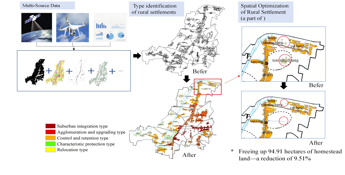
Based on the goal of classified promotion of rural revitalization in China's "Comprehensive Rural Revitalization Plan (2024-2027)". This study presents a framework to a comprehensive sustainable development assessment system using multi-source data. The proposed framework is applied to Sangxu town in eastern China to divide the settlements into five types and then optimize the spatial layout of rural settlements by employing spatial point pattern analysis, weighted Voronoi diagrams, and an extended breakpoint combination model. The study shows that, firstly, the overall development level of settlements in Sangxu Town is relatively high, but the distribution is uneven, with higher levels in the central and eastern regions and lower levels in the west. Secondly, based on the sustainable comprehensive development levels, 14 removal-type settlements (accounting for 27.45%), 21 control and retention-type settlements (41.18%), 7 agglomeration and upgrading-type settlements (13.73%), and 5 suburban integration-type settlements (9.80%) were identified. Thirdly, the activity intensity of residents is generally low in areas with low nighttime light intensity. The number of rural settlements is reduced to 37 after relocation, freeing up 94.91 hectares of homestead land—a reduction of 9.51%. The research has improved the application of big data technology in identifying the types of rural settlements and optimizing layout, providing experience for achieving sustainable development in rural areas in China.
Keywords:
land use
; rural settlements
; type identification
; optimization
; multi-source data
; rural revitalization
1. Introduction
Rural settlements, as the primary residential spaces for rural populations, are shaped by the interplay of natural, socio-economic, and cultural factors [1]. The rapid urbanization process has triggered a significant outflow of rural labor to urban areas in China, resulting in phenomena such as rural hollowing, homestead abandonment, and deteriorating living conditions [2]. Historically, the absence of systematic planning in China has led to rural settlements characterized by small-scale, fragmented layouts, and inefficient land use, posing substantial barriers to sustainable rural development [3]. Layout optimizing of rural settlements is thus a critical component of territorial spatial planning and comprehensive rural revitalization [4]. As outlined in the 2023 Central Document No. 1, coordinated efforts are required to enhance rural infrastructure and public services, develop livable and economically vibrant villages, and tailor revitalization strategies to local development status, location advantages, and resource endowments. Consequently, precise classification of rural settlement types and spatial layout optimization are imperative for improving land use efficiency and advancing rural revitalization.
Recent research on rural settlements’ spatial optimization has centered on three key domains: (1) evaluating development levels through lenses such as urban-rural integration [5], factor allocation, and the "three-life" (production-living-ecology) functions [6], alongside classifications based on factor endowment [7], rural resilience [8], and GIS-based spatial analysis; (2) constructing landscape ecological security patterns [9] with constraints derived from construction suitability [10], ecological livability [11], and the synergistic characteristics of production-living-ecological spaces [12]; and (3) prioritizing relocation criteria such as service radius [13] and farming radius [14]. Advances in computational techniques have facilitated the widespread application of intelligent algorithms (e.g., multi-agent models [15], CLUE-S, cellular automata, and FLUS models) in layout optimization. However, existing studies predominantly focus on macro-scale regions (e.g., eastern, central, and western China's plains [9]), with scant attention to micro-scale natural villages. Most of the data related to farmers' production, life and residence are obtained by questionnaire surveys, which often suffer from problems such as difficulty acquiring data, a long timeframe, high costs and slow data updates. Even though few scholars have applied POI data to analyze village path planning [6,12], the research scale is still confined to larger scales such as city (county). Moreover, the idle waste of rural residential land leads to the waste of rural land resources, which is not conducive to the sustainable development of the countryside. The inefficiently utilized residential land is the key object of optimization, while the existing studies about the identification of rural settlements’ types and optimization of the layout of the rural residential land involves less in the problem of the idle waste of rural residential land [16].
To address these gaps, this study presents a framework for evaluating the sustainable development levels in rural areas and adopts natural villages as analytical units, leveraging digital technology data such as nighttime light and POI data to efficiently derive indicators of rural development (e.g., resident activity intensity and infrastructure coverage). Then, scientifically evaluating the types of rural settlements and discussing the optimization of the layout. Obviously, this study contributes significantly to the field through its exploration of rural settlement type identification, particularly in advancing the methodology for dynamic and intelligent classification.
2. Materials and Methods
2.1. Study Area
Sangxu Town is located in the northeastern part of Shuyang County, Suqian City, Jiangsu Province, approximately 70 kilometers away from Suqian City. The town covers an area of 125.29 km², consisting of 4 communities and 20 administrative villages, with a registered population of 45,000 as of the end of 2018. Rural settlements in Sangxu Town are clustered near the town center and transportation hubs, while the rest are dispersed. In 2018, the peak kernel density of rural settlements reached 17.78 settlements/km², demonstrating a strong correlation with road networks and forming high-density clusters. However, settlements along rivers exhibit an irregular distribution pattern. The per capita rural construction land area in Sangxu Town is 0.023 hectares, significantly higher than the Jiangsu provincial standard of 0.014 hectares, indicating substantial potential for rural settlement consolidation. The town's secondary and tertiary industries are clustered along roads and rivers, with infrastructure tightly connected to transportation routes. However, the town faces challenges of uneven and insufficient development, including a lack of industrial, educational, and technological resources, which hinders its ability to meet residents' needs for a better life. Optimizing the spatial layout of rural settlements is critical to rational resource allocation, improving land use efficiency, and enhancing local development momentum.
2.2. Data Acquisition and Processing
This study employs natural villages in Sangxu Town as the analytical unit. The dataset comprises land use data, cultivated land quality data, nighttime light data, POI data, and socio-economic data. Land use data were derived from the 2018 land change survey database of Shuyang County, and cultivated land quality data were obtained from the 2019 cultivated land quality update evaluation database, both of which were provided by the Shuyang County Natural Resources and Planning Bureau. POI data were retrieved from the Shuijingzhu Information Service Platform (http://www.zkyq-tech.cn/), and nighttime light data were acquired from the High-Resolution Earth Observation System Hubei Data and Application Network (https://www.hbeos.org.cn/). Population data for natural villages were gathered via field surveys, while data on the number of enterprises, grain production, and primary industry output were extracted from statistical yearbooks. Data on industrial enterprise sales revenue and historical cultural heritage were sourced from the "Shuyang County Urban Master Plan (2014-2030)," "Sangxu Town Master Plan (2018-2035)," and local village records, provided by the Shuyang County Natural Resources and Planning Bureau and the Sangxu Town Land Management Office.
2.3. Research Process
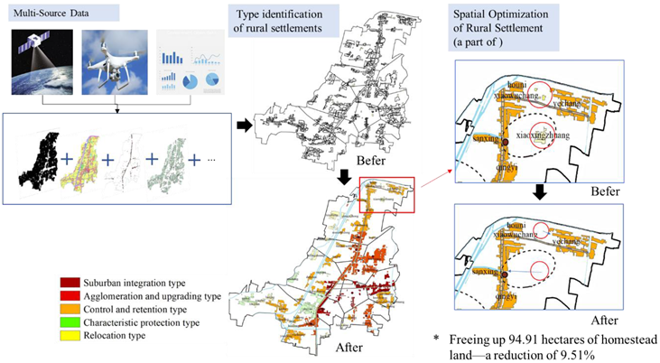
2.3.1. Research Framework
China has formulated and implemented the "Comprehensive Rural Revitalization Planning (2024-2027)", it emphasizes the need to refine village classification standards and promote rural revitalization based on four types of villages: agglomeration and upgrading-type, suburban integration-type, characteristic protection-type, and relocation and removal-type. Therefore, classifying villages is the foundation for implementing the rural revitalization strategy. Due to the principle of protection priority [17], this study first identifies rural settlements with historical cultural relics or natural landscapes as characteristic protection-type settlements based on the survey of natural resource endowments as well. Then, we construct a comprehensive evaluation index system for rural settlement development levels by using multi-source data such as POI, nighttime light, socio-economic, and land use data. Based on the comprehensive development level of rural settlements, the results are classified into three types by using the natural breaks method in ArcGIS: villages with poor, moderate, and good development levels. And then, they were classified as removal-type, retention-type, and development-type settlements, respectively [18]. Future optimization of removal-type settlements will primarily focus on demolition and relocation measures, whereas retention-type rural settlements will be improved through infrastructure and quality upgrades. Furthermore, those with significant location advantages are classified as suburban integration-type, while the rest are classified as agglomeration and upgrading-type[19] among development-type settlements. Finally, the study determines the relocation directions for settlements designated for removal using spatial point pattern analysis, weighted Voronoi diagrams, and an extended breakpoint combination model, and proposes governance strategies for different types of rural settlements. The framework for rural settlement type identification and spatial pattern optimization proposed in this paper is shown in Figure 1.
2.3.2. Classification of Rural Settlements
- Evaluation of Comprehensive Development Levels
Rural settlements are complex systems comprising multiple elements, with population, land, and industry being the core factors influencing rural development [20]. Location conditions and infrastructure serve as the fundamental support for rural development [21]. Therefore, this study constructs a comprehensive evaluation index system for rural settlement development levels, with population status, land use, industrial development, location conditions, and infrastructure level as the criterion layers (see Table 1). To eliminate the influence of different units, the data are normalized using the min-max method (see Equations 1-2), and the weights of the indicators are determined using the Analytic Hierarchy Process (AHP). The comprehensive development level of rural settlements is then assessed using a multi-factor evaluation method (Equation 3).
Positive indicators:
Negative indicators:
Comprehensive development level:
where S is the standardized score of the indicator, xi, xmax and xmin are the attribute value, maximum value, and minimum value of the indicator, respectively. Y represents the comprehensive development level score of the rural settlement, with higher values indicating higher development levels. Xi is the quantified score of the evaluation indicator i, wi is the weight of the evaluation indicator i, and n is the number of evaluation indicators.

Table 1.
Evaluation index of comprehensive development potential of rural settlements.
| Primary Indicators | Weight | Secondary Indicators | Indicator Explanation | Weight |
|---|---|---|---|---|
| Population Status | 0.250 | Population Size (C1) | Total registered population | 0.063 |
| Population Density (C2) | Registered population / total area of the natural village | 0.188 | ||
| Land Use | 0.250 | Per Capita Cultivated Land Area (C3) | Cultivated land area / registered population | 0.031 |
| Cultivated Land Quality (C4) | Area of fourth-grade land / total cultivated land area | 0.094 | ||
| Per Capita Construction Land Area (C5) | Construction land area / registered population | 0.031 | ||
| Resident Activity Intensity (C6) | Area of non-zero light pixels / rural settlement area | 0.094 | ||
| Industrial Development | 0.250 | Per Capita Agricultural Output (C7) | Agricultural output / registered population | 0.026 |
| Per Capita Planting Scale of Special Crops (C8) | Planting area of special crops / registered population | 0.065 | ||
| Per Unit Area Industrial Enterprise Revenue (C9) | Enterprise sales revenue / enterprise area | 0.159 | ||
| Location Conditions | 0.125 | Distance to Town (C10) | Distance from rural settlement to town center | 0.063 |
| Distance to Main Road (C11) | Distance from rural settlement to main road | 0.063 | ||
| Infrastructure Level | 0.125 | Public Service Facility Coverage (C12) | Coverage area of public service facilities / rural settlement area | 0.063 |
| Commercial Service Facility Density (C13) | Kernel density value of commercial service facilities | 0.063 |
- Resident Activity Intensity
The abandonment of rural homesteads has led to hollowed-out villages, resulting in severe waste of land resources and hindering improvements in rural living environments and sustainable development. Residential activity intensity is an important indicator for measuring the degree of village hollowing and the utilization of rural construction land [22]. Nighttime light remote sensing can capture weak light emissions from the ground at night, reflecting the vacancy status of rural homesteads during a specific period [23]. This study uses the area of non-zero light pixels to represent residential activity intensity, reflecting the current occupancy status of rural settlements. The formula is calculated as follows:
where Si represents the resident activity intensity of rural settlement i, AN is the total area of non-zero light pixels (63 ≥ DN ≥ 1), and A is the total area of the rural settlement (63 ≥ DN ≥ 0).
Si = 1−AN/A
- Infrastructure Levels
The completeness and rational layout of infrastructure profoundly affect sustainable rural development. Traditional infrastructure data often lacks accuracy and timeliness, whereas POI data, with its rapid updates, fine-grained classification, and extensive coverage of public service facilities, can effectively compensate for these shortcomings [24]. Therefore, this study extracts POI data for various infrastructure types in Sangxu Town to analyze the spatial distribution, completeness, and service coverage of infrastructure in the study area, thereby improving the timeliness and accuracy of the research.
a. Coverage of Public Service Facility
The proportion of public service facility coverage area to rural settlement area represents the accessibility of public services[25]. A higher value indicates better accessibility and convenience for residents to obtain public services. According to educational facility construction standards, the suitable service radii for middle schools, primary schools, and kindergartens are 1 km, 0.5 km, and 0.3 km , respectively. For rural areas, the service coverage radius for village-level public service facilities is set at a 15-minute walking distance, i.e., 1 km[26]. Therefore, this study extracts POI data for public service facilities such as kindergartens, primary schools, middle schools, and clinics in Sangxu Town and generates 1 km buffers to calculate the cumulative coverage area ratio of public service facilities for each rural settlement. The calculation formula is as follows:
where Rj is the public service facility coverage rate of rural settlement j, Dk is the area of rural settlement j covered by public service facility k, Sj is the total area of rural settlement j, dkj is the distance between rural settlement j and public service facility k, and d0 is the coverage range of public service facilities.
b. Density of Commercial Service Facility
Commercial service facilities in Sangxu Town include restaurants, supermarkets, entertainment venues, hotels, and financial institutions. the study generates a kernel density map of commercial service facility POI data using the Kernel method.
2.3.3. Layout Optimization of Rural Settlements
- Principle of Layout Optimization
Relocating and consolidating rural settlements are key to spatial layout optimization. Considering factors like farmers' relocation habits, farming distances, social networks, and costs, this study employs weighted Voronoi diagrams to delineate the sphere of influence for development-type settlements. Scattered settlements within the influence range of development-type settlements are relocated to these better-developed villages[27]. This approach eliminates chaotic layouts, optimizes underutilized land in central villages, and ensures infrastructure maintenance while preserving residents' lifestyles and social ties. Therefore, based on existing research[28], this study proposes the following relocation plan: (1) If only relocation-type settlements exist within the relocation distance, residents should relocate to the nearest suburban integration-type or agglomeration and upgrading-type settlement. (2) If there is only one suburban integration-type, agglomeration and upgrading-type, or control and retention-type settlement within the relocation distance, relocate to that settlement. (3) If there are multiple suburban integration-type, agglomeration and upgrading-type, or control and retention-type settlements within the relocation distance, relocate to the settlement with the highest comprehensive development level if they are of the same type, or prioritize suburban integration-type settlements if they are of different types.
- Analysis of Spatial Point Pattern
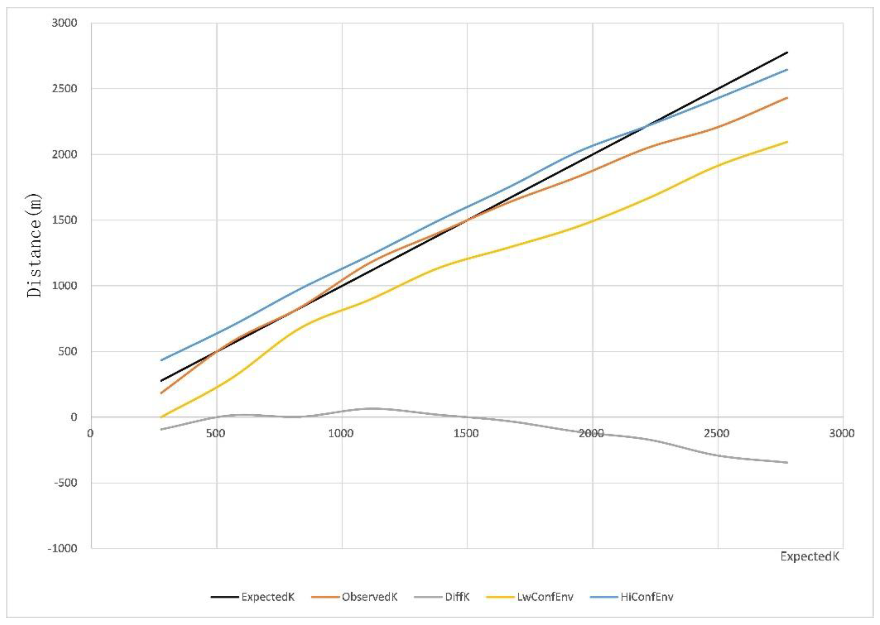
Various factors, such as residents' living habits and social networks, influence rural settlement relocation. Spatial point pattern analysis identifies the optimal inter-settlement distance in clustered configurations, determining a suitable relocation range. The Ripley's K-function quantifies the number of points within a circle of radius r in a finite point set. This function includes spatial distribution information of all point elements within the circle. The study applies this method to calculate the suitable relocation distance for rural settlements. The calculation formulas are as follows:
where is the expected value of randomly selected points falling within a circle of radius r centered at any point in the study area. Ir(uij) is 1 if the distance between points i and j is less than or equal to r, and 0 otherwise. wij is the ratio of the circumference of the circle centered at i with radius uij to the area A. A is the area of the study region, and n is the total number of point data in the study region. When L(r)=0, it indicates a random distribution; when L(r)<0, it indicates a uniform distribution; and when L(r)>0, it indicates a clustered distribution.
- Weighted Voronoi Diagram and Extended Breakpoint Combination Model
As mentioned earlier, the influence range of rural settlements with superior development conditions and location advantages serves as the basis for determining the relocation direction of removal-type settlements. The weighted Voronoi diagram model facilitates the determination of the spatial influence range of rural settlements, while the extended breakpoint model determines the relationship between the influence of rural settlements and spatial distance [29]. This study combines the two models to determine the relocation direction of rural settlements.
a. Voronoi Diagram Definition
Let P={p1,p2,p3,…,pn} be a finite discrete set of generator points on a plane, where no two points are coincident, and no four points are cocircular. The Voronoi diagram of any point pi in the set is defined as:
Where pj is a point in P different from pi, x is any point in the Voronoi diagram of pi different from pi, d(x,pi) is the Euclidean distance between points x and pi, and d(x,pj) is the Euclidean distance between points x and pj. Therefore, a standard Voronoi diagram can be understood as the irregular shape formed by the expansion boundaries of points in set P expanding outward at the same speed until they meet and stop expanding.
b. Weighted Voronoi Diagram Definition
The weighted Voronoi diagram is an extension of the standard Voronoi diagram, defined as:
Where pj is a point in P different from pi, x is any point in the Voronoi diagram of pi different from pi, d(x,pi) is the Euclidean distance between points x and pi, d(x,pj) is the Euclidean distance between points x and pj, and ωi, ωj are the weights of pi and pj in the point set.
The definition shows that in a weighted Voronoi diagram, the ratio between the distance from any point in a grid to the grid center and the distance from that point to the center of an adjacent grid is less than the ratio of the weights of the two centers. Therefore, all points within a region in a weighted Voronoi diagram are primarily influenced by the center point of that region. Thus, a weighted Voronoi diagram can be understood as the irregular shape formed by the expansion boundaries of points in set P expanding outward at different speeds until they meet and stop expanding.
c. Extended Breakpoint Model
Studies indicate that the influence of a city on its surrounding areas is proportional to the size of the city and inversely proportional to the distance from the surrounding areas to the city. The point where the influence of two adjacent cities achieves equilibrium is the breakpoint [30]. The calculation formulas are as follows:
Where dA and dB are the distances from the breakpoint to the two cities, DAB is the straight-line distance between the two cities, and PA and PB are the populations.
d. Weighted Voronoi Diagram and Extended Breakpoint Combination Model
The distance from the common edge of two weighted Voronoi diagrams to the two generators is proportional to their weights:
To determine the influence range of rural settlements, suburban integration-type and agglomeration and upgrading-type settlements serve as generators in the weighted Voronoi diagram, with their comprehensive development levels represented by weights derived from the square root of their influence [31]. The weighted Voronoi diagram and extended breakpoint combination model are used to divide the influence ranges of suburban integration-type and agglomeration and upgrading-type settlements, establishing a basis for determining the relocation direction of removal-type settlements.
3. Results
3.1. Identification of Rural Settlements’ Type
3.1.1. Characteristic Analysis of Nighttime Lighting Data and POI Data
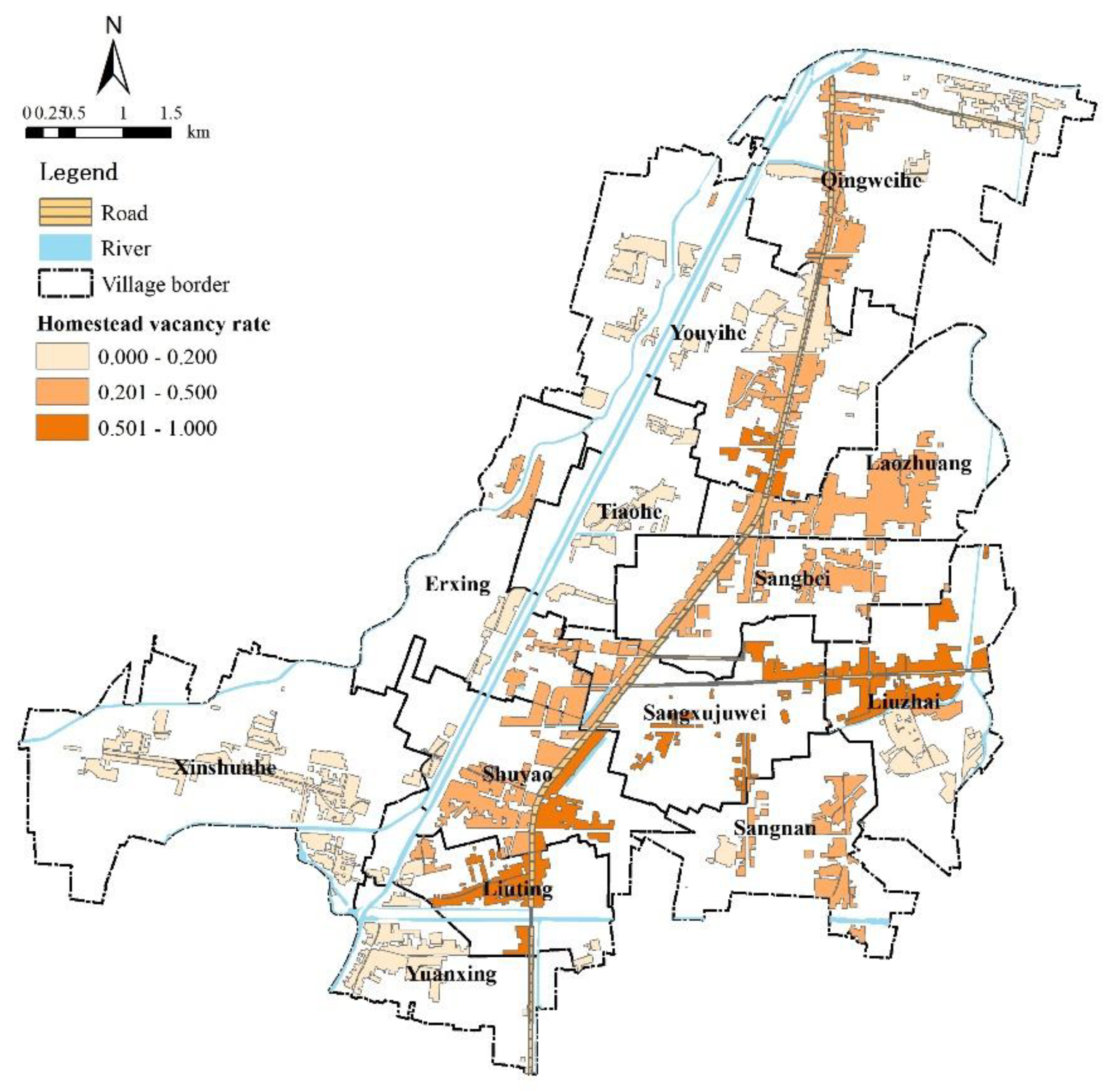
As illustrated in Figure 1, the overall residential activity intensity in the study area is relatively high, but there are marked spatial disparities. Rural settlements with low activity intensity are primarily located east of West Lake Street and southwest of Provincial Road 245, near the town center and main roads, with an activity intensity below 20%. Settlements exhibiting high activity intensity are primarily clustered along rivers or far from the town center, such as those along the Huangni River, Xuxu River, and Sangdong Ditch, with an activity intensity above 50%.
Figure 2.
Vacancy rate of homesteads in rural residential.
Commercial service facilities in Sangxu Town are primarily clustered along Provincial Road 245, with three high-density cores (43–67 facilities/km²) in Xiaowuchang, Huxu, and West Lake, and four medium-density cores (27–67 facilities/km²) in Qingyi, Laozhuang, Ganhe Community, and Liuzhai. These areas host a high concentration of wood processing enterprises, which attract rural laborers and boost local income and consumption levels, thereby supporting dense commercial service facilities.
Figure 3.
Distribution of Commercial Service Facilities and the core density of rural commercial service facilities.
Figure 3.
Distribution of Commercial Service Facilities and the core density of rural commercial service facilities.

3.1.2. Characteristic Protection-Type Settlements
Sangxu Town has four characteristic-protected settlements: Xinshunhe Village (with historical sites such as Fan Lihua's command platform, the Sangxu ancient well, and Ma Lianjia's monument), Tiaohe Village (with the local martyrs' cemetery), Shuyao Village (known for its long history of pottery making), and Maxingzhuang Village (with the natural landscapes along the Huangni River). These settlements are classified as protected-characteristic based on their historical and natural resources.
3.1.3. Evaluation of Comprehensive Development Level
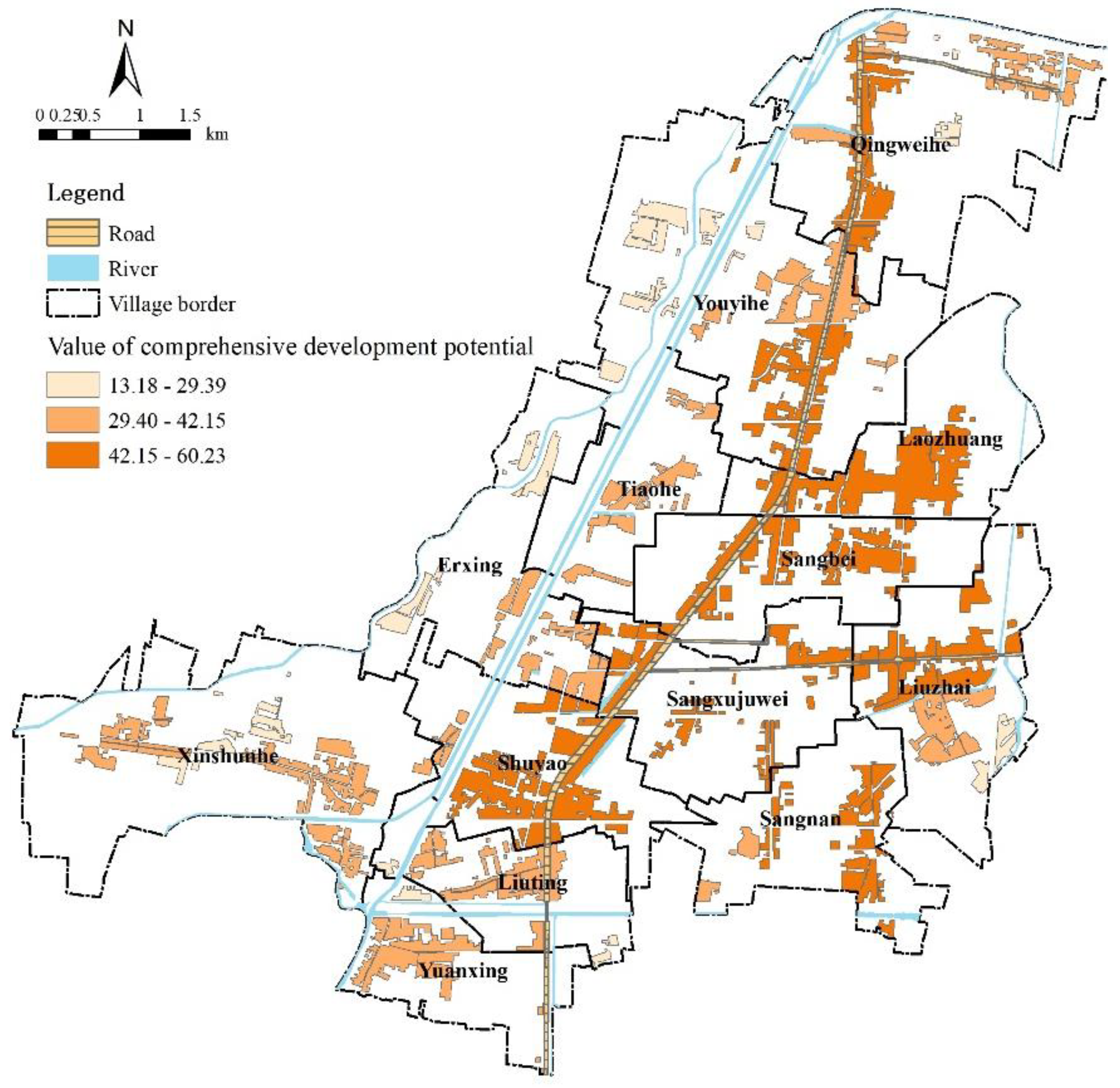
The overall development levels of rural settlements in Sangxu Town are evaluated using Equations 1 to 3 (Figure 4). The results show that 12 settlements (23.53% of the total) have the highest development levels, located near the town center and main roads, with strategic location advantages, large populations, and strong industrial development. There are 21 settlements (41.18%) have moderate development levels, located at a certain distance from the town center and main roads, with agriculture as the dominant industry, while secondary and tertiary industries are weak. There are 14 settlements (27.45%) have the lowest development levels, located far from the town center and main roads, with poor transportation, inadequate public services and infrastructure, and a weak economy.
Figure 3.
Classification results of comprehensive development potential evaluation of rural settlements.
Figure 3.
Classification results of comprehensive development potential evaluation of rural settlements.
3.1.4. Classification of Rural Settlement Type
Based on the comprehensive development level of settlements, relocation and consolidation-type settlements, as well as control and retention-type settlements, were identified. Furthermore, high-development-level rural settlements within a 1,500-meter buffer zone of the town center were classified as suburban integration-type using ArcGIS spatial buffer analysis, while high-development-level settlements outside this range were categorized as agglomeration and upgrading-type. The final classification results of rural settlement types and quantities are as follows: characteristic protection-type (4 settlements, 7.84%), relocation and consolidation-type (14 settlements, 27.45%), control and retention-type (21 settlements, 41.18%), agglomeration and upgrading-type (7 settlements, 13.73%), and suburban integration-type (5 settlements, 9.80%) (Table 2).
The spatial distribution map of settlements (Figure 5) reveals that:
(1) Suburban integration-type settlements are located in close proximity to the town center, primarily distributed along both sides of major roads, exhibiting significant location advantages. These settlements are characterized by larger scales, higher population densities, and relatively well-developed public services and infrastructure, which generally meet the daily needs of both local and surrounding rural residents.
(2) Agglomeration and upgrading-type settlements are situated at a moderate distance from the town center, with the exception of Daxingzhuang, all of which are adjacent to Provincial Highway 245, benefiting from convenient transportation and certain location advantages. These settlements exhibit larger scales and higher population densities. The concentration of numerous wood processing enterprises has effectively promoted local employment.
(3) Control and retention-type settlements are predominantly distributed along the banks of the Youyi River and Shuxin River, with relatively close proximity to the town’s main roads, providing them with certain location advantages. Compared to suburban integration-type and agglomeration and upgrading-type settlements, these villages host fewer industrial enterprises and primarily focus on the cultivation of Prunus triloba as their dominant industry. However, the lack of adequate public services and infrastructure hinders their ability to fully meet residents' daily needs.
(4) Relocation and consolidation-type settlements are fewer in number and smaller in scale, mainly located along the Huangni River in the western part of the town and the Gupo River in the south, far from major roads and the town center, resulting in unfavorable location conditions. These settlements lack industrial support and rely primarily on traditional crops such as rice, wheat, and corn, leading to lower levels of economic development.
(5) Characteristic protection-type settlements include Xinshunhe Village (Santai), Tiaohe Village (Miaopu), Shuyao Village (Shuyao), and Erxing Village (Machangzhuang).
3.2. Layout Optimization of Rural Settlements
3.2.1. Identifying the Optimal Relocation Distance for Rural Settlements
The analysis of rural residential patches in Sangxu Town demonstrated a clustered distribution pattern within the range of 500-1500 meters, as indicated by the observed K-values exceeding the expected K-values. The optimal relocation distance for rural residential areas is determined when the observed K-value equals the expected K-value. As shown in Figure 5, two intersection points between the observed and expected K-values were identified at 500 meters and 1500 meters. Given that a 500-meter distance is impractical for relocation, this study selected 1500 meters as the suitable threshold for consolidating and spatially reorganizing residential patches.
Figure 6.
Results of multi-distance spatial clustering analysis of rural settlements in Sangxu.
3.2.2. Determining the Influence Range of Development-Type Settlements
Furthermore, suburban integration-type and agglomeration and upgrading-type settlements serve as generators in the weighted Voronoi diagram, where their comprehensive development levels are represented by the square root of their influence as weights. The weighted Voronoi diagram combined with the extended breakpoint model is used to determine the influence range of development-type settlements (Figure 7).
3.2.3. Determining the Relocation Direction of Removal-Type Settlements
Following these principles, the relocation directions of removal-type settlements are determined (Figure 8), and the layout optimization plan is proposed (Table 3).
After relocation, the total area of removal-type settlements in Sangxu Town decreases by 94.91 hectares, accounting for 9.51% of the total rural settlement area. The number of settlements is reduced to 37, and the vacated homesteads can be reclaimed to supplement cultivated land, facilitating large-scale agricultural development. The reclaimed land can also be used to obtain new construction land quotas through the linkage of urban and rural construction land increase and decrease, providing land resources for industrial development, public services, and infrastructure construction, thus contributing to rural revitalization.
3.3. Optimization Paths for Different Types of Rural Settlements
3.3.1. Suburban Integration-Type
The five suburban integration-type settlements (West Lake, Caolouzhuang, Liuzhai, Luyao, and Yuanzhuang) are located near the town center and Provincial Road 245, with notable geographic advantages and a strong wood-processing industry. However, these settlements face issues such as inefficient land use and scattered industrial enterprises. It is recommended that scattered industrial enterprises be guided to relocate to industrial parks, progressively eliminating high-energy-consumption, high-emission, and low-efficiency enterprises. Additionally, new construction land quotas should be prioritized for building and improving public services, infrastructure, and clustered residential zones. The relocation of surrounding removal-type settlements to these areas should be carried out in an orderly manner, with vacated homesteads reclaimed for agricultural use or converted into green spaces to improve land-use efficiency and ensure a balance between cultivable and construction land.
3.3.2. Agglomeration and Upgrading-Type
The seven agglomeration and upgrading-type settlements (Daxingzhuang, Liuting, Huxu, Laozhuang, Nanxu, Ganhe Community, and Qingyi) are located further from the town center but near main roads such as Provincial Road 245 and West Lake Street. These settlements have certain locational advantages and should develop controlled plans to use new construction land quotas for building centralized residential areas and improving public services and infrastructure. Relocation of surrounding removal-type settlements to these areas should be encouraged to improve living conditions. Vacated homesteads can be reclaimed for agricultural use or converted into green spaces, or planted with special crops such as zelkova trees to increase villagers' income.
3.3.3. Control and Retention-Type
Control and retention-type settlements, such as Yechang and Hounizhuang, have moderate population densities and limited per capita cultivated and construction land. For settlements with low public service coverage, internal land resources should be utilized for village improvements and construction projects to meet the needs of residents and surrounding villages. Additionally, these settlements should strengthen connections with nearby development-type settlements to share public services such as kindergartens and primary schools, improving the efficiency and value of infrastructure.
3.3.4. Characteristic Protection-Type
For the four characteristic protection-type settlements (Xinshunhe Village, Maxingzhuang Village, Tiaohe Village, and Shuyao Village), it is essential to protect their unique characteristics while fully utilizing their natural and cultural resources. Land-use optimization, public-space shaping, and the development of special industries should be carried out based on village characteristics, residents' needs, and development bottlenecks to achieve sustainable development while highlighting the uniqueness of these villages.
3.3.5. Removal-Type
The 14 removal-type settlements, such as Xiaoxingzhuang and Xixuhong, are small in scale, with weak industrial foundations and poor location conditions. Relocation should be carried out in an orderly manner, with residents relocated to nearby suitable settlements or the town center. After relocation, vacated homesteads should be reclaimed to supplement cultivated land and promote large-scale agricultural development. The reclaimed land can also be used to obtain new construction land quotas through linking the increase and decrease of urban and rural construction land, providing land resources for industrial development and the construction of public services and infrastructure. Alternatively, the surplus quotas resulting from linking the increase and decrease of urban and rural construction land can be traded to obtain funds for improving rural public services and infrastructure and supporting relocation efforts.
4. Discussion
4.1. Methodological Advantages of Multi-Source Data
In studies related to rural and farmers, the research object and the study area are relatively microscopic, data involving typical micro-subjects such as farmers mainly come from statistical data, questionnaire surveys or interviews. This method of data acquisition often presents problems such as difficulty acquiring data, a long timeframe, high costs and slow data updates. At the same time, the subjective preferences of the researchers and the choice of survey methods also impact the credibility of the survey results. Currently, digital information technology is developing rapidly. Big data technology has advantages in terms of data acquisition, processing, and multi-source data fusion [44]. Because of its high data accuracy, fast updates, and low cost, big data is being used increasingly in urban planning, industrial layout, and agricultural and rural development research. To this end, a framework is constructed and the relevant data is then automatically integrated into the framework for analyzing the sustainable development levels of rural settlements, integrating multi-source data and leveraging big data technology to swiftly ascertain their characteristics. As shown in the following figure, settlements are classified into five types based on the comprehensive sustainable development levels, the type of rural settlements and their corresponding quantities are as follows: 4 characteristic protection-type settlements, 14 suburban integration type settlements, 21 agglomeration and upgrading type settlements, 7 control and retention type settlements, and 5 relocation and removal settlements. Besides, the suitable relocation distance for settlements targeted for relocation is 1.5 km, which is drawn from buffer analysis using POI data. After relocation, the number of rural settlements is reduced to 37, freeing up 94.91 hectares of homestead land—a reduction of 9.51%.
In addition, while we have employed multi-source data and digital technical approaches for the rapid identification of rural settlements’ types, in practice, the socioeconomic characteristics, core functions, demographic structures, and other characteristics of rural areas are in constant flux. Rural settlements at a low development stage currently may experience accelerated growth due to shifts in policies, planning, urban expansion, and other factors, which will induce dynamic changes in their types. Therefore, based on the framework proposed in this study, artificial intelligence (AI) technologies can be utilized to digitize key elements of agricultural and rural production and livelihoods, including land, settlements, and farmers. Concurrently, AI can facilitate the rapid retrieval, acquisition, and analysis of the latest regulatory requirements—such as those outlined in government policies and territorial spatial planning—that pertain to the classification and layout of rural settlements. This process will enable the development of a more comprehensive indicator system for analyzing the influencing factors of settlement types, thereby achieving intelligent, automated, and dynamic identification of rural settlements’ types and optimizing their suitable spatial layouts, it can reflect the sustainable development level of rural in the future more accurately. Obviously, this study contributes significantly to the field through its exploration of identification of rural settlements’ type, particularly in advancing the methodology for dynamic and intelligent classification.
4.2. Nighttime Light Data Reflects the Activity Intensity of Rural Residents and the Accuracy Verification Based on Field Investigation
Residential activity is important for measuring the degree of village hollowing and the utilization of rural construction land [33]. This study analyzed the activity intensity of rural residents using the nighttime light data. Nighttime lighting data is the image data formed by satellites using sensors to capture the lighting conditions on the ground at night. It can effectively reflect the status of human activities and has a high correlation with population and economy [34]. Specifically, we calculated the area of non-zero light pixels to represent residential activity intensity, reflecting the current occupancy status of rural settlements.
There is no doubt that nighttime light remote sensing can capture weak light emissions from the ground at night, reflecting the vacancy status of rural homesteads during a specific period. As illustrated in Figure 2, the overall residential activity intensity in the study area is relatively high, but there are marked spatial disparities. Rural settlements with low activity intensity are primarily located east of West Lake Street and southwest of Provincial Road 245, near the town center and main roads, with an activity intensity below 20%. Settlements exhibiting high activity intensity are primarily clustered along rivers or far from the town center, such as those along the Huangni River, Xuxu River, and Sangdong Ditch, with an activity intensity above 50%.
In fact, nighttime light data offers several advantages, including the rapid acquisition of low-altitude information, cost-effectiveness, and swift data updates. By collecting and analyzing nighttime light data in rural areas, it is possible to assess the activity levels of residents within these regions to a certain extent. This analysis provides valuable data support for identifying various types of rural settlements and optimizing spatial layouts. For example, the night light index of the Xixuhong and Dongxuhong located in the northwestern part of Sangxu Town are 0.18 and 0.22, respectively. Therefore, it indicates that the activity intensity of the residents in these two rurales are relatively low. In other words, it could be believed that there are fewer villagers here, and there may be problems of idle and wasted homesteads. In the future, they may be the target for optimizing rural residential areas. However, does a low settlement index reflected by night light data necessarily indicate a small number of villagers or idle houses in the area? The correlation between them is so important that it concerns the authenticity and reliability of the improved research framework in this study. Thus, to answer the above question, we designed an investigation plan for verification in Dongxuhong, a villagers' group in Youyihe Village. Concretely speaking, the number of households in Dongxuhong Group is 13 according to the "Village Annals of Youyihe Village", and then, we conducted on-site investigations of each household. The main contents of the investigation involve the following aspects: (1) The total population of rural households and the permanent resident population. (2) The family's willingness to move and the preferred location for relocation. (3) Whether farmers have multiple homesteads or the phenomenon of seasonal idleness, that is, farmers live in the village during the busy farming season but live in the county town or other houses outside the village during the off-season.
Surprisingly, the investigation found that most of the farmers in this group often do not live in the village or come back to live occasionally, with a proportion of about 80%, among whom some return to the village during farming or harvesting and work outside at other times. In other words, the proportion of relatively active villagers who have been living there for a long time in this villagers' group is approximately 20%, which is close to the intensity of residents' activities calculated by the night light data by comparing the survey data with the nighttime lighting data. Therefore, the scheme uses nighttime light data to reflect the intensity of residents' activities in the area is reliable in the study. The activity intensity of residents is generally low in areas with low nighttime light intensity. Such areas are potential targets for the demolition and consolidation of rural residential areas. It can be seen that, compared with the traditional investigations house-to-house by investigators, this alternative method can quickly identify the characteristics of residential areas, improve the convenience of data acquisition, reduce the cost of data acquisition and expand the scope of research.
4.3. Importance and Main Application of the Research Results
China’s “Comprehensive Rural Revitalization Plan (2024-2027)” establishes a policy of promoting rural revitalization based on four types of villages. This study introduces control and retention-type settlements based on local conditions and constructs a comprehensive evaluation index system to classify settlements depend on multi-source data which obtained by digital technology. In fact, the application of digital technology in rural issues is not limited to the research on identifying the types of rural settlements. The research on the revitalization and incremental control of rural residential land under the digital technology wave is another important aspect. The influence of digital technology on China's urban and rural regional system has been deepening in the 21st century [35], providing a new approach to the revitalization of existing land and the control of rural residential land expansion. Digital technology, by transforming diverse information into actionable data, has broken through the limitations of vector and raster data in traditional spatial research and revolutionized the coupling of land spatio-temporal and socio-economic data. This facilitates the accurate identification of regional farmers' land use demands, establishes a dynamic database of existing land use and urban-rural land transaction markets, and promotes the construction of a cross-regional land use "incremental -stock" land balance system.
Moreover, the digitalization of rural areas has expanded the connotation of rural settlements, extending their scope from material economic space to social and cultural dimensions. The future development of rural space will no longer rely solely on the expansion of land use scale but will shift to new social constructs such as virtual space and cyber culture derived from network connections and information interaction [36]. Against the backdrop of changes in rural population structure and the shrinking of physical space, digital technology plays a dual role: on the one hand, it effectively activates idle land resources (e.g., the reuse of abandoned homesteads) by eliminating information barriers between urban and rural areas, innovating utilization methods, and connecting with remote demands; on the other hand, through data mapping, the physical space and intangible elements of rural areas are liberated from geographical constraints, reshaping social cognition in the form of "virtual villages" and opening new paths for rural development.
4.4. Research Limitations and Future Directions
In this article, we have developed rules applicable to the relocation and consolidation of demolition-type rural residential areas, as well as an optimized layout plan based on the classification results. Specifically, a model was employed to simulate the optimal migration direction and appropriate migration distance for demolition and consolidation type residential areas. However, the relocation of rural settlements is comprehensively influenced by multiple factors, including regional society, economy, culture, policies, and farmers' willingness [37]. Focusing solely on the optimal distance simulated by the model may overlook the impact of certain critical factors on consolidation and relocation settlement. Therefore, improvements will be made in the following aspects in subsequent research: Firstly, construct an index system for influencing factors related to residential area layout optimization. Secondly, identify the key factors affecting layout optimization and develop a simulation model to reveal the influence mechanism of these key factors on migration distance and site selection. Finally, dynamically integrate these findings into the framework for optimizing the spatial layout of rural residential areas established in the preceding sections. By leveraging contemporary digital technologies, a more rapid, accurate, and scientific collaborative governance mechanism can be developed for the identification, spatial optimization, and classified management of rural residential areas.
It should be emphasized that under the current context of China's new urbanization strategy, rural residential area consolidation and resettlement plans must adhere to a people-oriented philosophy. That is, demolition and consolidation plans should consider farmers' subjective willingness. Participatory planning involving farmers facilitates the construction of beautiful and livable rural environments and supports the realization of China's rural revitalization strategy. Future research will focus on farmers' willingness regarding demolition and consolidation. Through surveys assessing farmers' subjective preferences for rural residential area consolidation, relocation, and site selection, the influence coefficient of farmers' willingness can be quantified. This coefficient will then be digitized and vectorized to generate spatial grid data reflecting farmers' participation willingness. Furthermore, integrating this data with multi-source big data will form a dataset for optimizing the spatial layout of rural residential areas.
Additionally, this study uses nighttime light intensity as a proxy for rural residents' activity levels, assuming weak nighttime light corresponds to low residential area activity or fewer residents. To verify this assumption, a natural village was selected as a sample for investigation. The investigation focused on the phenomenon of vacant homesteads and actual residence times of farmers within the village. Results confirmed that in residential areas with weak nighttime light intensity, there were real fewer actual residents or seasonal idleness issues. Thus, nighttime light data can represent residential area activity levels. However, it is important to note that the verification conclusions drawn from the same sample village may involve contingency and randomness, and their applicability to other regions remains uncertain. Therefore, in subsequent research, more extensive investigations of residential areas will be conducted, and a correlation analysis model linking field investigation data with nighttime lighting data will be constructed. This model will assess the degree of correlation between the two datasets, serving as a basis for identifying rural residential area types and optimizing spatial layouts, thereby enhancing the reliability of this paper's research conclusions. The proposed research framework has practical value and provides a reference for optimizing the spatial layout of rural residential areas in other regions.
5. Conclusions
This study establishes a framework for identifying rural settlements’ types and optimizing the spatial layout using multi-source data, and proposes governance strategies for different types of rural settlements. The results showed that the overall development level of settlements in Sangxu Town is relatively high, however, the distribution is uneven, with higher levels in the central and eastern regions and lower levels in the west. Based on the evaluation of comprehensive development level, 14 removal-type settlements (accounting for 27.45%), 21 control and retention-type settlements (41.18%), 7 agglomeration and upgrading-type settlements (13.73%), and 5 suburban integration-type settlements (9.80%) are identified. Removal-type settlements are small in scale and scattered in distribution, primarily situated along the Huangni River and Gupo River, far from the town center and main roads, with unfavorable locational conditions. The suitable relocation distance for removal-type settlements is 1.5 km. Within the influence range of development-type settlements, Xixuhong and Dongxuhong are relocated to Lizhuang, Zhongzhuang and Muzhuang are relocated to Liuzhai, Houdong and Haokou are relocated to Liuting, and Xingbei, Xingnan, and Luoxi are relocated to Ganhe Community. Due to relocation, the quantity of rural settlements decreases to 37, releasing 94.91 hectares of homestead land—a reduction of 9.51% of the total construction land. The evaluation index system, based on multi-source data, demonstrates high accessibility and applicability, serving as a methodological reference for assessing settlement development levels in other regions.
Author Contributions
Conceptualization, T.S. and J.G.; methodology, J.C.; software, T.S. and J.C.; validation, T.S. and J.C.; formal analysis, T.S.; investigation, T.S.; resources, T.S. and J.C.; data curation, T.S.; writing—original draft preparation, T.S.; writing—review and editing, T.S.; visualization, T.S. and J.C.; supervision, J.C.; project administration, T.S.; funding acquisition, T.S. and J.G. All authors have read and agreed to the published version of the manuscript.
Funding
This research was funded by Key Project of the National Social Science Foundation of China (No.23AZD032), Anhui Province Key Laboratory of Philosophy and Social Sciences Project (No.ZSKF202402) and Provincial Quality Engineering Project of Anhui Province (No. 2024shsjsfkc004).
Institutional Review Board Statement
Not applicable.
Informed Consent Statement
Not applicable.
Data Availability Statement
All data are available in the manuscript.
Acknowledgments
During the preparation of this manuscript, I have received a great deal of support and assistance. I would first like to thank my supervisor, Prof. Jie Guo , whose expertise was invaluable in formulating the research questions and methodology. Your insightful feedback pushed me to sharpen my thinking and brought my work to a higher level. I would particularly like to acknowledge my group mate, Jie Chen, for their wonderful collaboration and patient support. Finally, I would like to express my gratitude to the editors and peer reviewers of the Geographical Research journal. Thank you for spending your precious time reviewing this paper, which has given me the hope to refine and publish it.
Conflicts of Interest
The authors declare no conflicts of interest.
References
- Qu, Y.B.; Dong, X.Z.; Ping, Z.L.; Guan, M. Quality evaluation and improvement strategies of rural residential areas utilization from the perspective of human and land coordination. Transactions of the Chinese Society of Agricultural Engineering (Transactions of the CSAE) 2021, 37(18), 252-262.
- Duan, Y.Q. , Chen, S., Zhang, L,D., Wang, D., Liu, D.Y., Hou, Q.H. Spatial Distribution Characteristic and Type Classification of Rural Settlements: A Case Study of Weibei Plain, China. SUSTAINABILITY, 2023,15(11),8736.
- Guo, Y.Z.; Liu, Y.S. The process of rural development and paths for rural revitalization in China. Acta Geographica Sinica 2021, 76(6), 1408–1421. [Google Scholar]
- Zou, Y.; Yi, C.; Luo, F.; Du, P.; Liu, H.; Chen, T.; Song, Y.; Wu, P.; Zhou, Y. Revitalization paths for different types of rural settlements based on life cycle theory: A case study of a township in the farming-pastoral ecotone of northern China. Habitat Int. 2025, 163. [Google Scholar] [CrossRef]
- Zou, Y.F.; Luo, F.; Rao, Y.F.; Yi, C.F. , Wu P.Q. Optimizing the spatial layout of rural settlements in Farming-pastoral Zone under factor endowment and mobility. Transactions of the Chinese Society of Agricultural Engineering (Transactions of the CSAE) 2023, 39(11), 245-255.
- Zhu, X.L.; Qie, R.Q.; Zhang, W.Q. Rural settlement layout optimization based on minimum cumulative resistance from the perspective of production-living ecological space: a case study of Huinan County, Jilin Province. Journal of Agricultural Resources and Environment 2023, 40(5), 1063–1074. [Google Scholar]
- Zou, Q.X.; Zhang, A.L.; Zhao, K.; Xiong, Y.F. Spatial reconstruction of rural settlements in the hilly areas of southern China under the guidance of target differentiation. Transactions of the Chinese Society of Agricultural Engineering (Transactions of the CSAE) 2022, 38(17), 273-283.
- Liu, Y.; Liu, X.Y.; Yang, Q.Y.; Song, Y.Y. , Liu X.Y. Spatial layout optimization of rural settlements in Qinling-Bashan Mountains based on resilience theory. Journal of Southwest University (Natural Science Edition) 2023, 45(8), 165-175.
- He, J.H.; Jia, N.; Li, Y.J.; Qing, R.N. , Yan C. Layout optimization of rural residential areas in Hehuang Valley of northeast Qinghai Tibet-Plateau. Transactions of the Chinese Society of Agricultural Engineering (Transactions of the CSAE) 2021, 37(14), 258-265.
- Zhong, Q.; Xie, L.; Wu, J. Reimagining heritage villages’ sustainability: machine learning-driven human settlement suitability in Hunan. Humanit. Soc. Sci. Commun. 2025, 12, 1–19. [Google Scholar] [CrossRef]
- Shi, Y.; Zhu, X.W.; Li, J.H.; Ma, X.Y. , Zhao N. Optimal Layout of Rural Settlements in Gully Areas of the Loess Plateau Based on Multi-agent Bodies. Economic Geography 2023, 43(7), 170-178.
- Hassan, A.W.; Danrong, Z.; Guan, Y.; Ahmed, A.; Ifeanyi, C.O. Assessment of the Suitability of Water Quality Condition for Drinking and Irrigation Uses in African Urban Informal Settlements: Case Study Zaria Metropolis. Water, Air, Soil Pollut. 2025, 236. [Google Scholar] [CrossRef]
- Ye, Y.M.; Zhang, X.B.; Lin, Q.; Lin, F.F. A weighted setcovering problem model for optimal spatial layout of rural settlements: A case of Liusi town. Economic Geography 2017, 37(5), 140–148. [Google Scholar]
- Li, X.D.; Yang, Y.; Yang, B.; Zhao, T. , Yu Z.Y. Layout optimization of rural settlements in mountainous areas based on farming radius analysis. Transactions of the Chinese Society of Agricultural Engineering (Transactions of the CSAE) 2018, 34(12), 267-273.
- Liu, J.J.; Xia, M.; Liu, Y.Z.; Zhang, K. L, Zhang Z.H. Driving mechanism of rural land use change based on multi-agent system and cellular automata. Transactions of the Chinese Society of Agricultural Engineering (Transactions of the CSAE) 2018, 34(6), 242-252.
- Zhang, X.; Li, J.; Xu, J. Micro-Scale Analysis and Optimization of Rural Settlement Spatial Patterns: A Case Study of Huanglong Town, Dayu County. Land 2024, 13, 966. [Google Scholar] [CrossRef]
- Li, Y.R.; Bo, C.L.; Cao, Z.; Liu, X.H. , Liu Y.S. Village classification system for rural vitalization strategy: Method and empirical study. Journal of Natural Resources 2020, 35(2), 243-256.
- Zhou, N.; Hao, J.M.; Meng, P.; Chen, L. , Hong S.M. Layout optimization for county rural residents in Huang-Huai-Hai plain area and its remediation strategies. Transactions of the Chinese Society of Agricultural Engineering (Transactions of the CSAE) 2015, 31(7), 256-263.
- Chen, W.Q.; Dai, Y.Q.; Geng, Y.W.; Gao, H. , Ma Y. H. Village Classification Method Based on POI Data and Gravity Model. Transactions of the Chinese Society for Agricultural Machinery 2020, 51(10), 195–204. [Google Scholar]
- Guo, J.; Chen, X.; Zhao, Y.T.; Ou, M.H. Ou W. X. Research on the Key Scientific Questions of Village Planning Based on Rural Spatial Comprehensive Governance. China Land Science 2020, 34(5), 76–85. [Google Scholar]
- Tu, S.S.; Long, H.L.; Li, T.T.; Ge, D.Z. The Mechanism and Models of Villages and Towns Construction and Rural Development in China. Economic Geography 2015, 35(12), 141-147+160.
- Adityo, A.; Shibata, Y. The impact of the Javanese rural kinship settlement cluster development on spatial characteristic of traditional garden houses and resident activities. J. Asian Arch. Build. Eng. 2025, 1–23. [Google Scholar] [CrossRef]
- Du, G.M.; Zhang, S.; Li, D.M.; Li, W.Q. Yu J. X. Characteristics and Influencing Factors of Rural Holloerization of Black Soil Region at County Level. Research of Soil and Water Conservation 2020, 27(1), 176–182. [Google Scholar]
- Zhang, B.L.; Wang, Z.Y.; Zhu, M.J. Characteristics and driving forces of the mixed use of rural settlement land. Transactions of the Chinese Society of Agricultural Engineering (Transactions of the CSAE) 2022, 38(3), 267-275.
- Zhu, Z.; Yang, H.; Hu, Y.M.; Chen, F.X. , Ke C.P. Evaluation of village development potential and village classification by multi-source data. Journal of Agricultural Resources and Environment 2021, 38(6), 1142-1151.
- Cutts, B.B.; Darby, K.J.; Boone, C.G.; Brewis, A. City structure, obesity, and environmental justice: An integrated analysis of physical and social barriers to walkable streets and park access. Social Science & Medicine 2009, 69(9), 1314-1322.
- Liu, M.; Yuan, L.; Zhao, Y. Risk of Returning to Multidimensional Poverty and Its Influencing Factors among Relocated Households for Poverty Alleviation in China. Agriculture 2024, 14, 954. [Google Scholar] [CrossRef]
- Feng, D.J.; Shen, C.H. Layout optimization for rural settlements consolidation based on extended break-point model. Transactions of the Chinese Society of Agricultural Engineering (Transactions of the CSAE) 2014, 30(8), 201-209.
- Zou, Y.F.; Gu, X.X.; Luo, Y.T.; Wang, Q. , Jia G.R. Spatial layout optimization of rural settlements based on the theory of safety resilience. Transactions of the Chinese Society of Agricultural Engineering (Transactions of the CSAE) 2021, 37(12), 271-279.
- Feng, D.J.; Shen, C.H. Layout optimization for rural settlements consolidation based on extended break-point model. Transactions of the Chinese Society of Agricultural Engineering (Transactions of the CSAE) 2014, 30(8), 201-209.
- Liu, J.J.; Qie, Q.Q.; Liu, D.P.; Zhao, L. , Wang W.Y. Spatial Distribution Characteristics and Optimization Model of Rural Settlements Based on GIS - a Case Study of Nong'an, Jilin Province. Chinese Journal of Soil Science 2020, 51(4), 816-823.
- Omorede, A.; Prados, J.F.; Casas, A.C. Researching entrepreneurship using big data: implementation, benefits, and challenges. INTERNATIONAL ENTREPRENEURSHIP AND MANAGEMENT JOURNAL 2025, 21(1), 85. [Google Scholar] [CrossRef]
- Liu, L.; Gao, X.; Zhuang, J.; Wu, W.; Yang, B.; Cheng, W.; Xiao, P.; Yao, X.; Deng, O. Evaluating the lifestyle impact of China’s rural housing land consolidation with locational big data: A study of Chengdu. Land Use Policy 2020, 96. [Google Scholar] [CrossRef]
- Ma, T.; Zhou, Y.; Wang, Y.; Zhou, C.; Haynie, S.; Xu, T. Diverse relationships between Suomi-NPP VIIRS night-time light and multi-scale socioeconomic activity. Remote. Sens. Lett. 2014, 5, 652–661. [Google Scholar] [CrossRef]
- Fang, X.; Liu, M. How does the digital transformation drive digital technology innovation of enterprises? Evidence from enterprise's digital patents. Technol. Forecast. Soc. Chang. 2024, 204. [Google Scholar] [CrossRef]
- Li, Z.; Cheng, S.; Xiao, L.; Wei, Y.; Fang, T. Sustainability Benefit Evaluation and Optimization of Rural Public Spaces Under Self-Organization Theory. Sustainability 2025, 17, 1019. [Google Scholar] [CrossRef]
- Zhong, J.; Cao, Q.; Chen, R.; Liu, S.; Lian, Z.; Yu, H.; Zhou, N. Influencing Factors of Peasant Households’ Willingness to Relocate to Concentrated Residences in Mountainous Areas: Evidence from Rural Southwest China. Land 2024, 13, 1705. [Google Scholar] [CrossRef]
Figure 1.
A framework for rural settlement type identification and spatial pattern optimization.
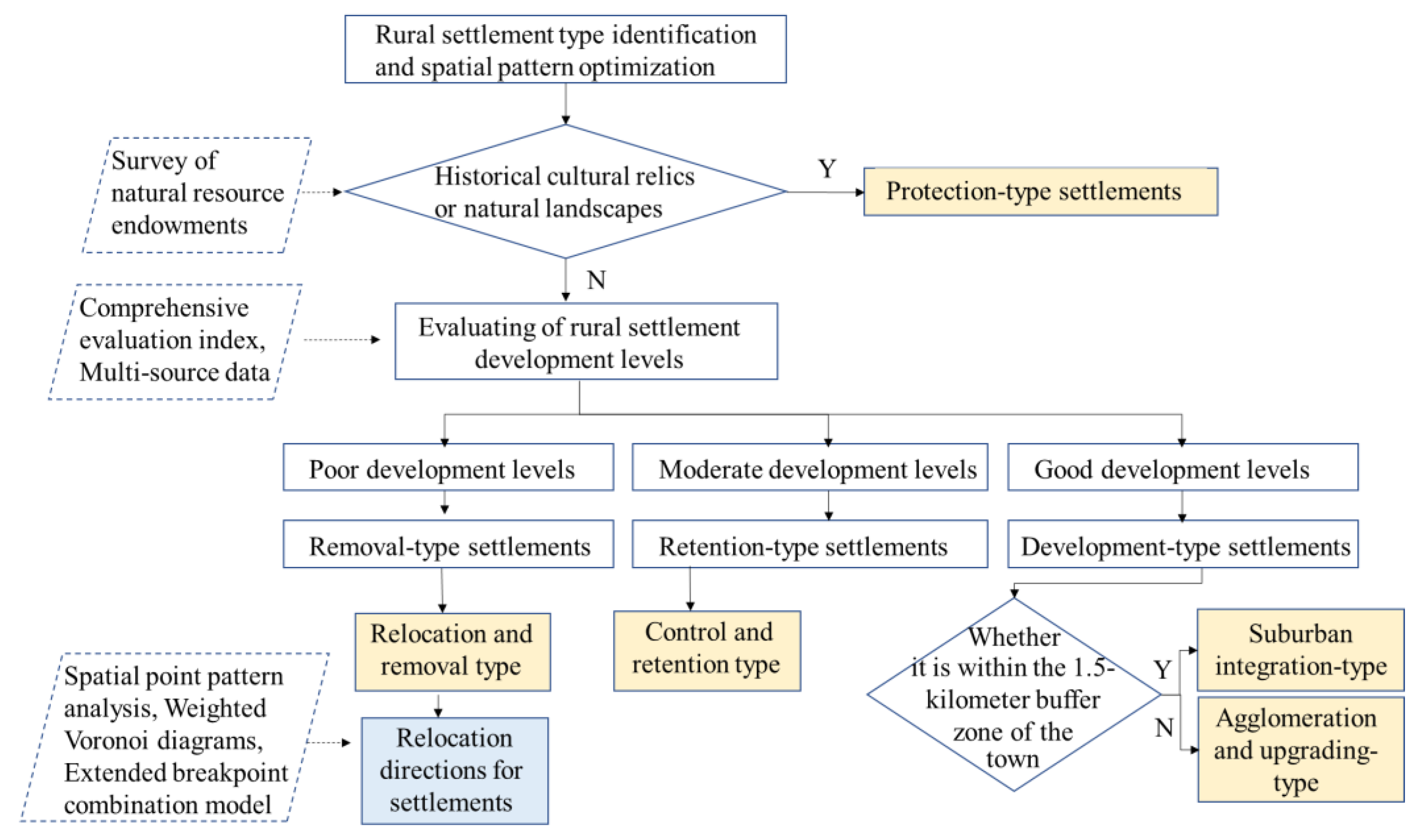
Figure 5.
Distribution map of rural settlement types.
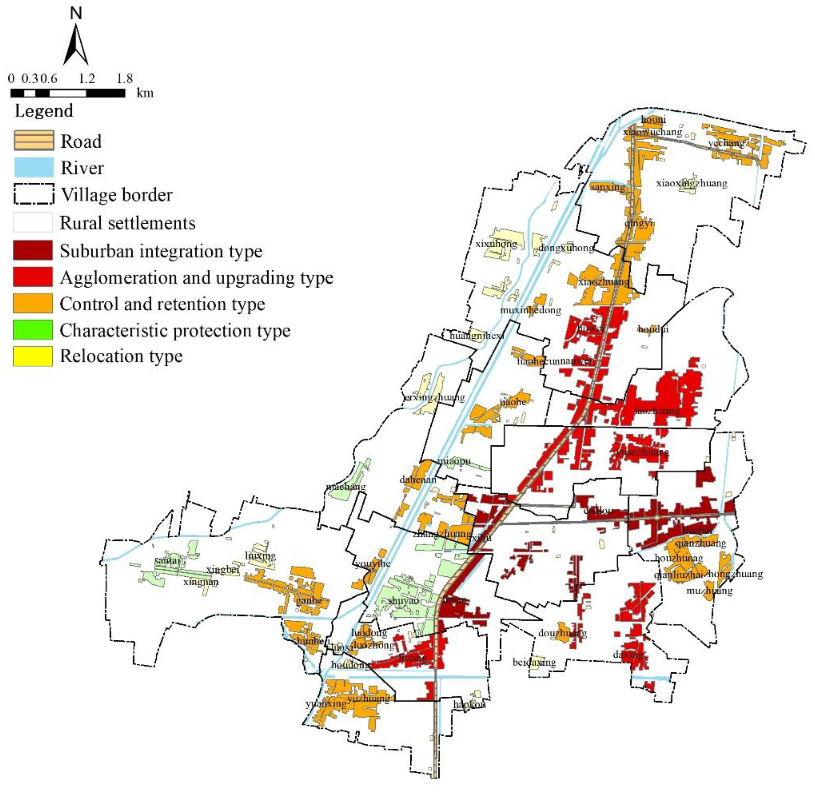
Figure 7.
Scope of influence of development-oriented natural villages.
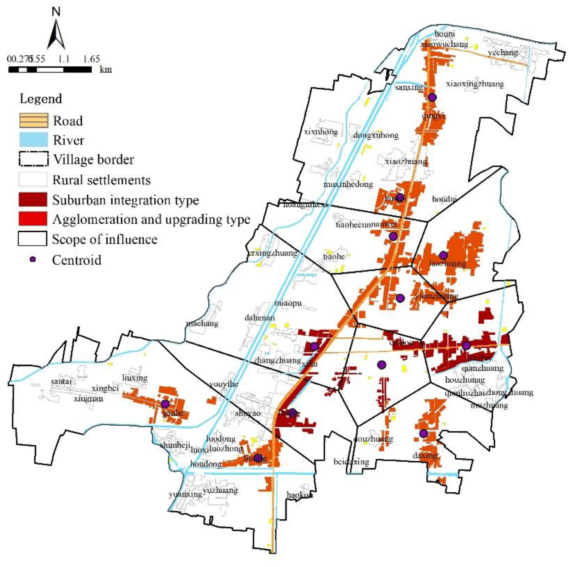
Figure 8.
Direction of relocation and consolidation of rural settlements.
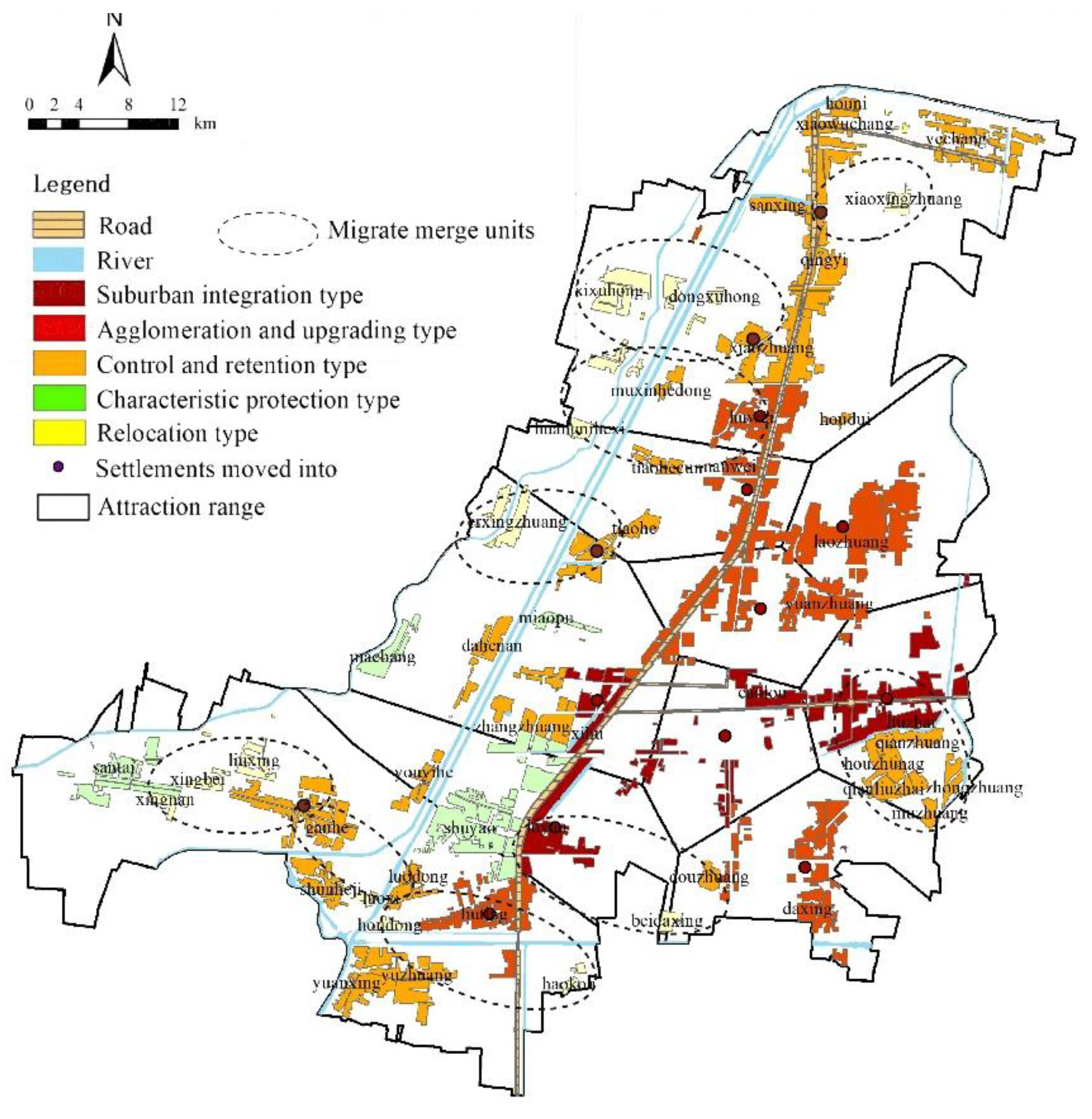
Table 1.
Classification results of rural settlement types.
| Type | Number | Name |
|---|---|---|
| Characteristic Protection-Type | 4 | Xinshunhe Village, Maxingzhuang Village, Tiaohe Village, Shuyao Village |
| Removal-Type | 14 | Xiaoxingzhuang, Xixuhong, Dongxuhong, Huangnihexi, Erxingzhuang, Zhongzhuang, Muzhuang, Liuzhuang, Xingbei, Xingnan, Luoxi, Houdong, Haokou |
| Control and Retention-Type | 21 | Yechang, Hounizhuang, Xiaowuchang, Sanxingzhuang, Yuzhuang, Lizhuang, Shuxinhe, Houdun, Tiaohe, Dayuwan, Zhangzhuang, Houzhuang, Qianzhuang, Yuanxing Village, Youyihe, Qianliuzhai, Douzhuang, Shunheji, Luozhong, Luodong |
| Agglomeration and Upgrading-Type | 7 | Daxingzhuang, Qingyi, Huxu, Laozhuang, Nanxu, Ganhe Community, Liuting |
| Suburban Integration-Type | 5 | West Lake, Caolouzhuang, Liuzhai, Luyao, Yuanzhuang |
Table 3.
Layout adjustment plan of rural settlements.
| Relocation type | Move into the village |
|---|---|
| Xiaoxingzhuang | Qingyi |
| Xixuhong | Lizhuang |
| Dongxuhong | Lizhuang |
| Huangnihexi | Huxu |
| Erxingzhuang | Tiaohe |
| Zhongzhuang | Liuzhai |
| Muzhuang | Liuzhai |
| Liuzhuang | Luyao |
| Xingbei | Ganhe Community |
| Xingnan | Ganhe Community |
| Luoxi | Ganhe Community |
| Houdong | Liuting |
| Haokou | Liuting |
Disclaimer/Publisher’s Note: The statements, opinions and data contained in all publications are solely those of the individual author(s) and contributor(s) and not of MDPI and/or the editor(s). MDPI and/or the editor(s) disclaim responsibility for any injury to people or property resulting from any ideas, methods, instructions or products referred to in the content. |
© 2025 by the authors. Licensee MDPI, Basel, Switzerland. This article is an open access article distributed under the terms and conditions of the Creative Commons Attribution (CC BY) license (http://creativecommons.org/licenses/by/4.0/).
Copyright: This open access article is published under a Creative Commons CC BY 4.0 license, which permit the free download, distribution, and reuse, provided that the author and preprint are cited in any reuse.


