Submitted:
06 July 2025
Posted:
08 July 2025
You are already at the latest version
Abstract
Slope failures represent a major threat to human life and infrastructure worldwide, and they often lead to significant disruptions of economic and environmental systems. Landslide mitigation works, which are used to retrieve the damaged (from the landslide) environment, sometimes lack methodologies to integrate resilience into infrastructure projects economically and sustainably. The necessity of developing resilience in civil engineering technical works is getting more obvious since the outcomes from natural disasters, such as those of landslides and floods become more frequent since 2000 and onwards. In this direction, this article aims to describe slope failure mitigation measures through a resilience framework through a case study from a road adjacent to a local stream in the Region of Attica (Greece). A geological-geotechnical study was carried out in the context of the restoration of the road surface and the stability of the stream slopes. The results of the geotechnical study and the mitigation measures executed under the implementation of a resilience approach are presented. The purpose of this article is to describe the process of implementing aspects of resiliency into the civil engineering technical works and to evaluate the effectiveness of implemented strategies for improving the resilience of infrastructure.
Keywords:
engineering resilience
; matrix
; civil engineering landslide mitigation measures
; robustness
; adaptability
1. Introduction
Disasters caused by natural hazards often lead to
significant economic and environmental problems in society. Thus, increasing
attention is placed on strengthening the “disaster resilience” of communities
at site specific, to improve a priori disaster risk reduction and expost
recovery.
To this direction, Eurocode 7 (EC7), the
(landslide) risk assessment approach and the factor of safety method are three
important geological-geotechnical tools that are used to estimate potential
failures and as a result take appropriate actions to avoid undesirable
consequences regarding the safety of the proposed civil engineering mitigation
measures. However, considering the concept of infrastructure resilience, all of
them (e.g., Eurocode 7, Risk Assessment, the factor of safety method) are
associated with some disadvantages mainly in its practical application, such
as:
Eurocode 7 (EN 1997) although it attempts to be
scientifically based, in several places it uses semi-empirical methods that
require “mechanical judgment” without clear instructions. This can lead to
different approaches to the same project by different engineers. In addition,
EC7 covers basic geotechnical problems (e.g., bearing capacity, subsidence),
but does not provide sufficient guidance for: (a) Complex soil conditions, (b)
Dynamic phenomena (earthquakes, liquefaction), (c) Deep stability problems
(e.g., large slopes, tunnels). Finally, EC7 does not fully incorporate the
geotechnical consequences of earthquakes (e.g., liquefaction, loss of bearing
capacity), which are critical in earthquake-prone regions such as Greece.
On the other hand, landslide risk assessment is
critical for natural disaster management, but risk-based approaches are only
appropriate for events that can be forecasted under usual threats. Furthermore,
the factor of safety method, even though it is an important approach for the
stability estimation in geological and geotechnical engineering, it lacks the
capability of considering the uncertainty of geomaterials mass, something that
results in making it hard to estimate the reliability of the civil engineering
landslide mitigation works [1].
Taking into consideration the above-mentioned, a
quantitative resilience assessment approach for geological and geotechnical
issues is needed. The word “resilience” was introduced to the engineering world
more than twenty years ago for research in the field of earthquakes [2]. To the author’s knowledge and according to
findings from other researchers, research in the resilience of geotechnical
field is lacking [3–5]. Furthermore, a
quantitative resilience assessment for geotechnical engineering issues is
missing [4]. Thus, to implement the concept of
resilience into practical applications in geological and geotechnical
engineering, a particular framework is necessary. To this end, this approach
can be achieved by presenting characteristic metrics and indicators to understand
the resilience of geotechnical assets. Thus, the concept of engineering
resilience is going to be presented through the implementation of technical
works taken place in a provincial road in the Region of Attica in Greece, where
many slope failures and subsidences, historically, have been occurred the last
twenty years and pose disorder to transportation normal functionality to the
broader area.
The case study is focused on Dekeleias Street
(named Provincial Road 3, under the jurisdiction of the Region of Attica, very
close to the National Motorway from Athens to Thessaloniki, adjacent to the
Chelidonous Stream, which is a tributary of the Kifissos River, one of the most
significant rivers in the Attica Region), where failures have occurred on the
road surface. In the examined area, the last two decades (e.g., 2005-2022),
slope failures, subsidences and undermining have taken place at the boundaries
of the road with the banks of the stream. These failures can be attributed to
surface erosion because of inadequate drainage of rainwater and to wider
instability of the adjacent slopes due to the erosive action of the stream (Figure 1, Figure 2).
The idea of facing those failures was based on
establishing a solid understanding of what contributes to the under-examination
road disaster resilience and how it can be measured. In the context of roadway
rehabilitation, geotechnical site investigation as well as stability and
rehabilitation studies of the roadway were conducted by the Directorate of
Technical Works (Central Section) of the Regional Authority of Attica.
As part of the roadway rehabilitation, including
investigating the stability of the slopes of the sections of the road in
question, topographic survey, geotechnical survey, geotechnical study, study of
the stability of the roadway, study of the stabilization & rehabilitation
and traffic study were authorized by Directorate of Technical Works of the
Region of Attica.
In the present study, the hazard of the existing
condition of the stream slopes and their adjacent District Road 3 is confirmed
using the Rock Engineering System methodology. The specific methodology is
presented, and the slope failure parameters that contribute to the instability
of the study area are briefly described. Its application led to the calculation
of the slope instability index, which confirms the results obtained from the
execution of the geotechnical investigation and study carried out, leading to
specific types of technical road support works. To address the erosive
mechanisms, it was proposed to construct pile walls made of intersecting piles
of different diameters and walls on piles anchored, due to the significant
resistance heights obtained, with a passive anchoring system of deadman type [6].
Considering the above-mentioned, this paper aims to
discuss approaches that improve the understanding of engineering resilience to
landslide mitigation measures as well as to propose tools that aim to estimate
disaster resilience.
Thus, the structure of the paper is as follows:
firstly, a description of the geology and geomorphology of the area of interest
as well as the presentation of the geological-geotechnical study and
construction works is briefly provided. Secondly, in Material and Methods
Section, the terms of the Driver-Pressure-State-Impact-Response framework that
are associated with engineering resilience are presented. In addition, the Rock
Engineering System semi-quantitative methodology is described with the intention
to prove the pre-existing potential slope failure of the examined road, by
estimating the landslide instability index through a matrix. In the Section of
Results and Discussion, those terms of resilience are integrated with the steps
of the design and construction process of the project, and an alternative
expression of the above-mentioned matrix is used to apply resilience. Finally,
the paper closes with the Conclusions.
1.1. Geological and Geotechnical Setting of the Study Area
The study area is in the western foothills of the
Penteli Mountain, specifically east of the Kifissos River and adjacent to the
Chelidonous Stream (Figure 3). The
morphological topography of the area is characterized by a gentle, flat terrain
with very gentle slopes. The wider area geologically consists of Neogene and
Upper Miocene formations. The road section under study runs through the
Kifissos Lake formations, according to the geological map of IGME (e.g., Greek
Geological Research Institute), geological sheet of Kifissia (1.50.000 scale).
To investigate the nature of the formations along
the failures of the problematic section of Dekeleias Road, four sample
boreholes with a total depth of 65 meters and field and laboratory tests were
carried out. The field work took place in March 2018 (Figure 4a, b).
1.2. Evaluation of Geotechnical Investigations
Considering the results of the geotechnical
investigation, the field and laboratory tests and all available data, the
following sections with uniform geotechnical characteristics were distinguished
[6]: (a) modern artificial embankments, (b)
alluvial deposits and (c) lake and pond formations. An aquifer level was
detected in all the executed boreholes. In two boreholes, the water level
corresponded with the bed of the Chelidonous stream, which passes a short
distance away. In the other two boreholes, the phenomenon of artesianism
occurred. Based on the evaluation of the abovementioned formations,
geotechnical measures were proposed for design parameters, range and
characteristic value for each of them, and geotechnical simulations were
prepared for the areas under consideration. After evaluating the findings of
the geotechnical investigation and considering the geometrical characteristics
of the areas in which the geotechnical problems were identified, the study
areas were divided into subareas such as A, B, C and D (Figure 5). The division of the areas also
considered the morphology of the road slopes, the geological and geotechnical
conditions, the distance of the road from the Chelidonous stream and the
failure mechanisms evaluated per area.
1.3. Geotechnical Study—Description of the Constructed Technical Works
The proposed solution is an example of targeted
resilience strengthening investment and action. To address the erosive
mechanisms, it was proposed to construct pile walls made of intersecting piles
of different diameters and walls on piles anchored, due to the significant
resistance heights obtained, with a passive anchoring system of deadman type [6]. To avoid soil erosion between the reinforced
piles on the outer side of the retaining project, unreinforced piles are
provided between them that reached a depth greater than that of the existing
stream bed [9]. Area A was examined separately
from the other three areas B, C and D, as it is located at a great distance
from them and was divided into subareas A1, A2 and A3 to consider the
variations in the morphological characteristics of the road slopes and failure
mechanisms. Analyses of the internal failure or excessive deformation of the
structure (STR) and failure or excessive deformation in the ground (GEO type
limit states according to EN 1997-1) were carried out on critical control
cross-sections covering the most adverse conditions per study area. The results
showed that the lower limits of the safety factors defined by the relevant
regulations are covered [6]. The selected
solutions are summarized as follows.
Area A
In Area A, the main contributing factor to the
failure mechanism is estimated to be, based on the failure morphology, the flow
of the stream as the stream bed approaches the roadway slope (Figure 5). Area A was divided into three
subareas (A1, A2, A3). Subarea A1 starts after the turn from the Athens Lamia
Highway (Lainopoulos location) and extends 8.50 m to the west. To address the
erosion mechanisms in subarea A1, it was decided to construct a pile wall with
interlocking piles Ø1.00 m with the reinforced piles having an axial spacing of
1.7 m. Subarea A2 starts from the end of area A1 and extends 32.90 m to the
west. In this area, significant undermining has occurred on the existing road
with the crown of the existing steep slopes bounded within the road zone. To
address the erosion mechanisms, anchor walls 3.0 m and 5.5 m high constructed
founded on interlocking piles of Ø1.00 m diameter at 1.7 m intervals. In this
section, the retaining elements (piles, retaining walls) needed to be anchored.
Subarea A3 starts from the end of area A2 and extends 5.10 m towards the west.
To address the erosive mechanisms in area A3, it was decided to construct a
pile wall with intersecting Ø1.00 m piles with the reinforced piles to have an
axial spacing of 1.7 m (Figure 6a, b).
Areas B, C, D
The main factor causing the failure mechanism in
areas B to D is the flow of the Chelidonous stream, which causes erosion at the
foot of the road slopes (Figure 5). The
erosion of the foot and the gradual change in slope gradient to steeper
gradients cause generalized slope stability problems affecting the existing
Dekeleias Road in the form of soil movement and subsidence of the roadway on
the stream side. It should be noted that in areas where the stream, due to its
natural flow, is near the Dekeleias road, such as in areas B and D, the foot of
the road slopes is also the boundary of the streambed, and as a result, the
instability problems were more pronounced. In area C, the stream moved away,
and the erosion problems appeared milder [6].
A significant contribution to the occurrence of
failures was also made by surface stormwater runoff, which was uncontrolled
through the natural slope of the road due to the absence of a drainage system.
In addition, the underground aquifer, which in some places took the form of
artesianization, had an adverse effect on the overall stability of the slopes.
Based on the above, area B was divided into two (2) subareas, B1 and B2, and
area D was divided into five (5) subareas, D1 to D5, to consider the variations
in the morphological characteristics of the road slopes and the failure
mechanisms.
Area C was treated as an area with uniform
morphological and geotechnical characteristics. Subarea B1 started after the
technical culvert which has been constructed after the church Zoodochos Pigi to
drain the stream water under Dekeleias Street from upstream to downstream and
extends for 10.10 m to west. The failures on the roadway in this area were due
to the erosion of the slopes caused by the flow of water exiting the culvert,
as well as the failure to manage the surface runoff of stormwater runoff. Rainwater
collected on the upstream side of the road through the culvert flowed
uncontrolled through the culvert into the bed of the natural stream, causing
erosion of the existing adjacent slopes. In addition, the uncontrolled surface
flow of rainwater on the road surface caused localized undermining of the road.
(Figure 2). To address the erosive
mechanisms in subarea B1, a pile wall was constructed with interlocking Ø1.20 m
piles, with the reinforced piles having an axial spacing of 2.0 m. Subarea B2
started from the end of area B1 and extended 24.20 m to the west. In this area,
the main contributors to the failure mechanism were estimated to be stream flow
and groundwater, while surface water flow appeared to have little or no
contribution based on the morphology of failures. As a result, localized soil
instabilities and subsidence occurred in Area B2, affecting the existing
Dekeleias Road, but on a smaller scale than the adjacent Area B1. To address
the erosive mechanisms in subarea B2, a pile wall with Ø1.00 m piles was
constructed at an axial spacing of 1.7 m.
Area C started from the end of area B2 and extended
to 28.20 m to the west. In area C, it was estimated that the road slopes were
in a state of limit equilibrium. The main factor contributing to their
destabilization mechanism was estimated to be the erosive action of the stream.
The local soil instabilities and subsidence that occurred immediately were
small in scale due to the removal of the natural flow of the stream from the
road slope, but works were needed to contain the erosive mechanisms to protect the
road from future larger scale failures. To address the erosive mechanisms in
Area C, it was decided to construct a pile wall with Ø1.00 m piles at an axial
spacing of 2.3 m.
Area D is divided into five (5) subareas, D1 to D5,
as mentioned above, starting from the end of Area C and extending approximately
87.00 m in length to the west, numbered sequentially.
In subareas D1 to D5, the main contributing factor
to the failure mechanism was estimated to be the flow of the stream as the
stream bed approached the road slope. As a result of this action, localized
soil instabilities and subsidence occur in areas D1 and D5 in the lower portion
of the roadway slope, affecting the existing Dekeleias Road. Similarly, in
areas D2, D3 and D4, local soil instabilities and subsidence occurred, which
affected not only the lower part of the slope but also the upper part of the slope
in contact with the existing Dekeleias Road. To address the erosive mechanisms
in areas D1 to D5, interlocking piles Ø1.00 m and Ø1.20 m were constructed with
reinforced piles having axial spacings of 1.7 m and 2.0 m, respectively. In
subareas D2, D3 and D4, retaining walls of 1.5 m to 3.0 m high founded on the
interlocking piles are also planned. It should be noted that in all areas and
subareas, the project was decided upon, and then the diameter of the piles and
their axial spacing were calculated.
The geotechnical study was fulfilled in January
2019, whereas the stabilization work started in September 2020 and accomplished
in September of 2023. In Figure 7 (a–g),
characteristic views from the construction phase of areas B to D are depicted.
In the following section, the above-described
construction phase will be integrated into an engineering resilience framework.
2. Materials and Methods
The term “resilience” originated from the Latin
word “resiliere” [1], while Holling [10], expressed that resilience is the measure of
the persistence of systems and of their ability to absorb change and
disturbance.
In terms of hazards and disasters, even though
resilience has been part of the research literature for decades, the term first
discussed among national governments in 2005 with the adoption of The Hyogo
Framework for Action by 168 members of the United Nations to ensure that
reducing risks to disasters and building resilience to disasters became
priorities for governments and local communities. Disaster resilience has been
described as a process, an outcome, or both, and as a term that can embrace
inputs from engineering and the physical, social, and economic sciences [11].
In the field of civil engineering projects,
resilience is the ability of a system to withstand disruptions and continue to
function by rapidly recovering from and adapting to the disruptions [12]. The necessity of integrating resilience into
infrastructure is getting more urgent nowadays since the frequency of natural
hazards increases [3]. In the following, the
concept of resilience will be developed through the description of the process
of the design and implementation of the civil engineering works of the selected
case study.
2.1. Engineering Resilience
The meaning of resilience in civil engineering
projects is associated to the preparedness and response of a system against
catastrophic events. Preparedness is basically related to the ability of
proactively mitigating the effects of disastrous events by providing adequate
resources and designing strategies prior to the disruption [3].
The term “response” includes the meanings of
“absorption” and “recovery”, where they both are expected after the event of
disruption [13,14]. Absorption is the
immediate response of an infrastructure system in which the system withstands
the disruption, and recovery is the organizational efforts to rapidly repair
the damaged system, and the consequential effects propagated to other systems [3]. The above-mentioned terminology can be depicted
through a graphical curve which illustrates how an engineering system’s
performance changes over time considering a disruptive episode [15]. Figure 8
shows a characteristic degradation and recovery of system functionality over
time.
Absorption of shocks is reflected by the
degradation of the system functionality at the event of disruption (from time td
to ta). The recovery efforts can be initiated immediately by
post-disruption; however, the system functionality can be unchanged for a
certain period of time (from time ta to tr) until
adequate resources are collected and response strategies are organized (this is
the assessment stage). Finally, it is expected that the system functionality
recovers to an acceptable level for its normal operation (from time tr
to tf).
An alternative scheme of the resilience framework
in the transportation network, such as in our case study, is given below (Figure 8a). Crucial issues in this figure are
the metrics of the reduced level of service and the time required to restore
that service [16].
Bruneau et al. [17]
described further the meaning of resilience by defining four properties:
robustness, rapidity, resourcefulness, and redundancy. Robustness is the
ability of technical works to resist the impact of hazard events, such as
landslides, floods, etc. Rapidity is associated with how quickly the
infrastructure recovers after an event, which depends on the available
resources and the damage level [5].
Resourcefulness is the capacity to identify problems, establish priorities, and
mobilize resources (i.e., monetary, physical, technological, and informational
resources). During the assessment stage ta to tr,
resourcefulness can contribute to lessening the time of assessment.
Furthermore, resourcefulness can contribute to developing mitigation measures
for disaster prevention and contribute to the recovery process [3]. For example, sufficient monetary and
informational resources reduce the time in identifying damages or vulnerability
of the system. Redundancy indicates the extent to which existing elements or
systems are substitutable. Redundancy and resourcefulness are the means to
improve the resilience of an infrastructure. For example, the resilience of a
road network (as it is for the examined case study) can be improved by ensuring
that alternative routes can be used [18],
during the restoration of deteriorated components [5]).
The same researcher [17]
further categorized resilience within the engineering discipline into different
dimensions such as technical, organizational, environmental [3], social, and economic. Technical dimension
includes all the technological issues related to the construction [19]; organization dimension includes all the
management activities and response to emergencies [19];
environmental dimension is associated with the influence of the constructed
technical works on the surrounding environment (slopes, stream, fauna and
flora) and the increased carbon dioxide emissions due to the prolonged time
travel after the slope failures and the subsequent closure of the road; social
dimension considers the impacts of failure of infrastructure system to social
groups; and economic dimension refers to economic losses, both direct and
indirect, because of the occurrence of the disaster, as well as the subsequent
rehabilitation [19]. Based on the
above-mentioned, a resilient system should be characterized by the following [4]: reduced failure probabilities, reduced
consequences from failures, reduced time to recovery.
2.2. DPSIR Framework
DPSIR (Driver-Pressure-State-Impact-Response)
framework has been used as a resilience assessment framework implemented to
geotechnical infrastructure (Figure 9).
“Drivers” and “pressures” describe the hazard
scenarios applied to a civil engineering project. For example, slopes and
bridge foundation (as in the examined case study), are crucial factors in
transportation networks. Therefore, the drivers affect the users’ travel
behavior and business logistics [3].
As a result, the driving forces result in
pressures, which can be identified as the effect of climate change or funding
constraints.
“States” includes the robustness, rapidity,
resourcefulness and redundancy of the examined infrastructure [3]. The states indicate the metrics that represent
the resilience of a civil engineering project. An example of this will be
presented in the following section by quantifying the resilience through a
matrix table and an index.
The technical, economic, organizational,
environmental and social effects can be described by the impacts [20]. Last, disaster management and decision-making
are associated with the term of response [3],
which will be described by mentioning the series of civil engineering
construction and bureaucratic procedure steps that needed for the restoration
of the damaged road segment.
Τhe above-mentioned terms are going to be
integrated into the description of Provincial Road 3’s restoration.
2.3. A Semi-Quantitative Methodology [Rock Engineering System (RES)]
To quantify the response of geotechnical
environment in terms of their limit states as well as to confirm the hazard of
the geological-geotechnical condition of the slopes of the study area before
the restoration technical works, the Rock Engineering System (RES) methodology
was used [21]. This methodology is mainly
based on the correlation of mechanisms between landslide parameters through a
matrix table and uses parameters that can potentially be identified during the
preparation phase of a preliminary, final or implementation study of an
engineering project. The scope of using RES is to estimate the landslide
instability index. The simplest matrix is one that illustrates the effect of
parameter A on parameter B and vice versa the effect of B on A (Figure 10).
The basic principle of the matrix—table is to place
the parameters studied for the occurrence of failures along a principal
diagonal and to study the interactions of the specific parameters outside the
principal diagonal (Figure 11), through a
cause—effect linkage.
The concept of the RES methodology is an objective
approach that allows the use of all data relevant to a technical project, to
match the specific methodology with the conditions on the ground. This is
achieved by a series of actions, which are the following: (a) selection and
rating of the parameters associated with the slope failure, (b) construction of
a matrix in which the selected parameters are placed on the main diagonal of
the matrix and their binary interactions located outside the main diagonal are
studied, (c) analysis of the binary interactions between the parameters, (d)
coding the meaning of each interaction [For the purpose of the present work, a
range of possible interactivity from 0 to 4, corresponding to `none’ (coded 0—most
stable conditions), `weak’ (coded 1), `medium’ (coded 2), `strong’ (coded 3)
and `critical’ interactions (coded 4—most favourable condition for slope
failure) is adopted], (e) calculation of the weighting coefficient of each
parameter, and (f) estimation of the instability index by using the following
equation: Ii=Σai x Pij, where i refers to parameters (from 1 to 10), j refers
to the examined slope and ai is the weighting coefficient of each parameter
given by the formula: ai=1/4 * [(C+E)/(ΣiC+ ΣiE)]%, scaled to the maximum
rating of Pij (maximum value=4). Pij is the rating value assigned to the
different categories of each parameter’s separation which also fits better to
the conditions related to the parameter in question regarding the examined
slope failure.
The instability index is an expression of the inherent potential instability of the slope, where the maximum value of the index is 100 and refers to the most unfavourable conditions. In the following section, the abovementioned steps are analytically presented and discussed.
2.3.1. Selection and Rating of Landslide Parameters
At the site considered, RES methodology was implemented, and ten landslide parameters associated with the specific failure were selected [8,22,23]. The selection of the appropriate parameters was based not only on valuable knowledge from literature and mainly on the overall experience gained from the study of landslide phenomena in Greek territory and additionally from case studies from all over the world but also on their affinity with landslide occurrence in the case study area. Ten parameters were selected as independent controlling factors for the landslide occurrence and each factor was classified into 5 classes. These factors, which were utilized for the RES methodology, were:
(i) Human activity (distance from roads): The shorter the distance of a slope from a linear axis (e.g., road), the more likely (under certain conditions) it is that the slope will fail. In the area under consideration, the distance of slopes from provincial road 3 (Dekeleias Road) is less than 50 m.
(ii) Tectonic regime: In the area under consideration, the tectonic regime is weak, i.e., associated with the near absence of significant tectonic events.
(iii) Slope inclination: The slope gradient is an important parameter in considering the initiation of a landslide, and in most landslide studies, it is considered the main initiating factor or triggering parameter. At the studied site, due to the steep depositional slope (>45°), the parameter was calibrated with a value of 4.
(iv) Slope orientation: Slope orientation is influenced by solar radiation, wind and precipitation and thus strongly influences hydrological processes through evapotranspiration. It influences sedimentation processes (formation of a weathering mantle), the moisture content of the soil, vegetation and root growth and consequently leads to a reduction in soil strength. Based on the above, the parameter was given a value of 4 (0°–45°, 135°–225°).
(v) Lithology: From investigations carried out in the Greek territory, it is proven that the lithological composition and the strong variation in the lithostratigraphic structure, which results in a sequence of formations with completely different geotechnical characteristics, have a significant influence on the occurrence of landslides. At the location under consideration for the Neogene and Quaternary formations, a value of 3 is taken for this parameter.
(vi) Hydrogeological conditions: The presence of water is most often decisive for the final behavior (failure or not) of the geological materials on which a technical project is based. In the study area, because the formations involved are alluvial deposits over a Neogene basement, the parameter “hydrogeological conditions” was calibrated with a value of 2.
(vii) Rainfall (Precipitation): Rainfall is one of the most important external factors that contributes to the occurrence of landslides and mainly triggers movement. It has been observed that during periods of increased rainfall, the frequency of landslides is high since it causes a change in pore water and increased hydrostatic pressures. In addition, weathering processes (chemical and mechanical) are triggered, along with erosion caused on a slope by surface water. In the study area, the phenomenon of failures is dynamic, and the main reason for this is the intense and prolonged rainfall that has taken place there over time (especially during the period October 2018–February 2019). For the case study, the average annual rainfall from the measuring adjacent meteorological station in Tatoi is 450 mm. Due to the above, the parameter was calibrated with a value of (1).
(viii) Vegetation: Vegetation plays an important role in controlling soil erosion and can help stabilize a slope through mechanical resistance in the subsoil. It provides a protective layer on the land surface and regulates the transport of water from the atmosphere to the land surface, soil and underlying rocks. In general, slope stability is very sensitive to changes in vegetation cover. Considering the standard criteria used by the Greek Ministry of Rural Development to evaluate different sites and field observations, the category “moderate vegetation” characterizes the examined area with a score of 2.
(ix) Distance from streams: Research has shown a close spatial relationship between the occurrence of landslides and the presence of streams. One of the causes of potential changes in the geometry of a stream slope is the erosion that the stream contributes to removing the support of the adjacent slope. This removal is one of the most common factors in causing landslides. The rate of lateral erosion of a stream is related to its depth, the erodibility of its geologic material, and the velocity of its flow. However, the proximity of the slopes to the stream beds also contributes to the degradation of the geomechanically characteristics of the geological materials that make up the slopes. It has been found that as the distance from streams increases, the frequency of landslides generally decreases. In the study area, the distance of the slope from the stream is almost negligible (less than 50 m) and is therefore rated with a maximum value of 4 (critical interaction).
(x) Distance from tectonic features: It is generally known that the presence of a fault zone due to the action of tectonic forces from a geomechanically point of view: (a) drastically reduces the cohesion of the rock in a zone along the fault and (b) affects the hydrogeological regime of the wider area either by increasing the permeability in the aforementioned zone and creating a selective groundwater drainage axis or by decreasing the permeability, which leads to an influence on the geomechanically behavior of the formations affected by the aforementioned fault elements. The study area is located approximately 3-4 km east of the nearest active fault [6]. Therefore, it does not directly affect the study area (rating: 0).
The rating and interpretation of the selected parameters (Table 1) was carried out based on the technical-geological data of the slopes of the study area, considering data from research on landslides in Greece [8,22,23]. In Table 1, the selected parameters are presented and their ratings representing the local geological and geotechnical conditions of the study area are highlighted.
2.3.2. Construction of the RES Matrix—Calculation of the Landslide Instability Index
According to the methodology analyzed in subsection 2.3, the construction of the RES matrix, the estimation of weighted coefficients, and the calculation of the instability index are presented (Table 2). Regarding the way the matrix has been constructed, a characteristic indicative interaction among the selected landslide parameters in Table 2 is described (by assigning the appropriate coding value) in detail below. For example, the tectonic regime of the case study area has a critical influence on lithology, as represented by the value 4. On the contrary, concerning the influence of lithology on tectonic regime, there is a weak interaction (rating equal to 1). For better understanding of the interactions between the selected parameters, the reader is advised to read the following references [22,23].
Based on the geological and geotechnical data of the specific study area, the existing information was decoded (quantified), and through the RES methodology, the instability index was calculated and found to be equal to I=65.07. The instability index in this study is related to the categorization of landslide susceptibility proposed by Brabb [24], that is, to the average of the percentage of the area under failure to the total area of interest through lithological or geological units (Table 3).
According to Table’s 3 categorization, the instability index for the examined Dekeleias road and its adjacent Chelidonous stream slopes confirms the failures that have already occurred on this road [Landslide with Relative Susceptibility Numbers or RSN (Relative Susceptibility Numbers): L= 54-70%].
3. Results
This section will apply the concepts of engineering resilience through the description of a geotechnical project (e.g., case study of the Provincial Road 3): from the identification of the initial problem and the site investigation to the design, financing and implementation of the technical works. At the same time, the response to extraordinary events that occurred during the construction of the works (such as: a. the installation of drainage system wells due to the all of the sudden occurrence of water on the surrounded slopes during the construction stage of B to D area, b. the subsidence-collapse of part of the bridge—culvert near the Church of Zoodochos Pigi, c. the preparation of a supplementary—additional study after the agreement of a supplementary contract regarding the restoration of the previously mentioned damaged of bridge—culvert, d. the launch of the CONVID-19 pandemic period that caused a significant delay in the beginning of the project procedures (e.g., delays due to the initially general traffic ban from the Greek Government) will be commented on.
To begin with, over the last twenty years, part (e.g., with a length of about 300m and especially in the section adjacent to the Kifissos River) of the Provincial Road 3 faced problems of both slope failures and subsidence, because of the severe bad weather phenomena, the resulting erosion and its proximity to the adjacent stream of Chelidonous. Thus, due to:
1) The phenomenon of the erosion of the slopes of the examined road on the side of the Chelidonous stream was dynamic and had caused, owing to heavy rains on October and December of 2018, new significant problems in the roadway and its slope (conditions of undermining of the road) compared to the time of the announcement of the study (three years ago),
2) The failure to manage the stormwater from the road and the stream, a failure of the existing retaining wall and the parallel exposure of the public utility networks had already occurred. In addition, the above phenomena were exacerbated by the absence of drainage of stormwater from the road for the safe drainage of rainwater,
3) The consequence of the previous finding was the unsafe passage of vehicles and pedestrians due to increased danger and the clearly continuously deteriorating existing condition of the roadway and the parts of the slopes supporting it,
Provincial Road 3 had poor resilience. Therefore, a need for mitigation measures to enhance the resilience of the road was necessary and geotechnical engineering needed to play a significant role in this response [16]. The Directorate of Technical Works (Central Section) of the Region of Attica decided in 2016 to definitively address the problem by awarding a topographic survey and geological—geotechnical research and study to a specialized consulting firm after an open tender. The study was carried out during the two-year period 2018-2019, which proposed specific technical works to remove the existing risk. After a significant period had elapsed during which the urgency of the issue had to be clarified and the source of funding sought, the Directorate of Technical Works of the Regional Authority of Attica launched an open tender where the final bidder was awarded the implementation of the technical works proposed by the geotechnical study. Construction work started in March 2020 (start of CONVID-19 pandemia) and was successfully completed in spring 2023. To translate the above actions into the engineering resilience concept, the following steps were executed:
According to the terminology described in Section 3.1 (Engineering Resilience), the ability of the existing infrastructure of the examined road before the reconstruction of the Provincial Road was weak (inadequate robustness and technical dimension) and lacked the geotechnical and geological characteristics that could resist erosion and undermining of the road due to heavy rainfall and inadequate drainage system. As a result, the concept of rapidity was raised, meaning how quickly the infrastructure recovers after an event. Thus, judging by the damage level and the available resources, the rapidity of the reconstruction process was moderate (organization dimension), taking into consideration the identification of the emerging geotechnical problems, the difficulties of establishing priorities and mobilizing monetary resources (Resourcefulness stage), not to mention the constraints in terms of budget priorities. To this end, some extra problems raised, such as the period of COVID-19 pandemic which was initiated just at the beginning of the construction stage and for a period of three (3) months no construction works could be done due to traffic curfew from the Greek Government. Furthermore, during the construction phase of areas B to D, between areas A and B (at the end of area B) of the road and specifically at the height of the Church of Zoodochos Pigi, further erosion of the roadway slope was created (of 21.80 m), which manifested itself in the form of collapse of part of the existing retaining wall and with a sliding volume of soil. The new erosion of the roadway slope was due to the heavy rainfall of recent years, has been dynamic and has progressed in time to the present day. To restore the traffic on the road and to limit the future extension of the phenomenon, it was considered imperative to modify the original design, to include additional works to support the above described 21.80 m long section. As a result, this led to additional geotechnical study and extra budget being provided.
As far as redundancy it concerned, which indicates the extent to which existing elements or systems are substitutable, during the reconstruction face of areas A to D, alternative transportation route was used (social dimension) resulting in the closure of the examined segment of the Provincial Road 3 for approximately three years. Lastly, speaking about the economic dimension (direct economic losses because of the above-mentioned phenomena), the total amount of the reconstruction stage was equal to the amount of two (2) million euros approximately, without including in this amount of money the indirect costs from the closure of the particular segment of the Provincial Road 3.
Referring to the DPSIR (Driver-Pressure-State-Impact-Response) framework, slopes and bridge foundation (e.g., drivers), were important factors in the transportation network of the examined area, since they affected the users’ travel behavior and business logistics [3] and consequently resulted in pressures, which can be identified as the effect of climate change or funding constraints. The robustness, rapidity, resourcefulness and redundancy of the examined infrastructure are associated with the term “States”, which indicate metrics that represent the resilience of a civil engineering project. The technical, economic, environmental and social effects can be described by the impacts. Last, disaster management and decision-making are associated with the term of response [3], which described by mentioning the series of civil engineering construction steps that needed for the restoration of the damaged area.
3.1. Quantitative Framework to Evaluate Resilience
To evaluate the effectiveness of the above-described mitigation measures for improving the resilience of the geological—geotechnical environment of the examined case study, a (resilience) matrix approach [from a different perspective that the previous described (RES)] has been developed, which includes both quantitative and qualitative data under the context of the resilience process.
For the construction of this matrix, it is important to consider not only the engineering resilience of a civil engineering project in the existence of a disruptive event (e.g., flood, landslide, etc.) but also the cascading impacts of it, such as what impact has to the people (social), the surrounding environment and the economy [20].
To this direction, the Resilience Matrix (RM) consists of an 8 x 8 matrix (Table 4), where the columns describe the most important parameters of any system (e.g., technical, environmental, social and economic) and the rows depict the steps of a disruptive event (preparation, absorption, recover, adaptation), [25]. The aim of technical resilience is to minimize the probability of failure in case of the existence of a severe meteorological or earthquake event [20]. On the other hand, social, environmental or economic resilience can be the (derivative) impacts (e.g., positive or negative, overestimated or underestimated respectively) of technical resilience [20].
In order to perform a resilience assessment and understand an adverse event (e.g., the consequences of a heavy rain on to a road functionality), the following steps should be taken [25]: (i) definition of the system boundary (e.g., road adjacent to a stream) and threats (e.g., natural disaster: slope failures, subsidence and undermining of the stream slopes), (ii) identification of critical functions such as the transportation system functionality, (iii) selection of indicators (meaning that each cell of the matrix acts as an value of how well the system behaves) implementing expert judgement on a relative numerical scale from 0 (being the least resilient or having the highest impact), 1 (low), 2 (medium), 3 (high) to 4 (very high resilient), (iv) assessment of the overall resilience of the system by aggregating the cells scores across the matrix.
3.2. How is the Resilience Matrix Table Working?
Taking into consideration that the most critical function is the proper operation of the Provincial Road 3, the technical—absorption cell is assigned a rating according to the ability of the system to withstand any new heavy rainfall episode in such a way that will be able to resist from potential failures similar to those that resulted in the road devastation before the civil engineering mitigation measures took place. To succeed in accomplishing that in the case study of the Provincial Road 3, building codes, construction procedures (Lee et al., 2018) numerical models and engineering analyses took place, during the working out of the geotechnical study of the examined area taking into consideration different alternatives—scenarios regarding the occurrence of extreme weather events. Regarding the interaction of technical—adaption, the appearance of subsurface drainage during the construction works in areas B to D, resulted in the construction of a drainage system well with the intention to regulate the groundwater.
Another example is the interaction between economics and recovery. In this, a rating is assigned based on the assumption that the size of the potential slope failure would adjust the time of the repair works needed for the restoration of the road. In case of a new road closure due to new failure, the citizens’ perception of the surrounding examined area is estimated to be positive, because minor new technical mitigation works will be required. To this direction, the interaction between economic—preparation will lead to less budget than the one needed for the restoration of the road.
Considering the environmental impact from the one side was deteriorated due to the increased carbon dioxide emissions because of the prolonged time travel after the disruption but on the other side slope failures, subsidence and undermining were restored, and the environmental view of the examined area was restored too. Studying the interaction of environmental—social aspect of resilience, it can be said that in high frequency but lower impact events as a storm, the society needs to be able to function to the fullest extent possible, whereas in lower frequency but higher impact events such as disastrous landslide, the services for response and survival will be very important in order to allow to return to socio-economic functionality [16].
Regarding the technical—preparation cell, the ability to proactively mitigate the effects of the disruptive events by constructing subdrainage systems confirm the capability of appreciating the scale of the rescue task and devising strategies prior to disruption.
Finally, studying the relationship between social and preparation, public safety and quality of life are connected to how well-prepared society is, because the absence of preparation in the appearance of a natural hazard is associated with the lack of understanding and information on the effects of a disruptive event. On the other hand, speaking about the relationship between social and absorption, one could say that the restoration of the road can improve the daily life of the people that cross by that segment of the examined Provincial Road 3. As far as the relation between social and adaption it concerns, it can be highlighted that the closure of the Provincial Road 3 due to the civil engineering restoration works affected partially the local traffic and as a result the access to social needs such as emergency services or medical care [4].
Thus, the above-mentioned remarks are quantified in the following Table 5, which mentions the ratings for each cell of the resilience matrix, estimated by the author of this manuscript, considering the road functionality, as well as the improved geotechnical conditions of the examined study area, after the mitigation works. The rating for each interaction has been assigned to an analogous way as the one estimated for the landslide instability index in Section 3.2.2.
To an analogous calculation as the one estimated for the landslide instability index (Section 3.2.2), the resilience index for the road segment of provincial road 3 is calculated as follows:
Based on the Australian Disaster Resilience Index (ADRI) [26], which is a nationally standardized index of Australian communities’ capacity for disaster resilience, the estimated Resilience Index for the examined case study, after the fulfillment of the restoration technical works, was found to be equal to 78.40. Taking into account that the disaster resilience is a protective characteristic that acts to reduce the effects of, and losses from, natural hazards not only regarding the resilience of individuals, but also the resilience as a system of social, economic and institutional factors and based on the following Table 6, it is concluded that the Resilience Index for the examined segment of the Provincial Road 3 after the accomplishment of the restoration mitigation measures is categorized as high disaster resilience.
In the following Figure 12, the performance of the calculated resilience index, associated with the performance of the Provincial Road 3 (before the disastrous event, during the period of the design phase and the construction stage and after the restoration of the road) is depicted.
4. Discussion
As mentioned in the subsection 2.3, the selected parameters for the construction of the RES matrix were based on the cause—effect interaction. The same philosophy has been followed for the implementation of DPSIR framework, regarding Provincial Road 3 [e.g., the cause-effect relationships of hazard to the geotechnical behavior of the mitigation technical works of the case study [4]. Thus, the “drivers” (e.g., driving forces), in our case study are the slopes and the bridge foundation which are important components in transportation networks because they provide mobility for passengers and goods to the destination point [4]. “Pressures”, such as serious subsidence to the examined case study road, can take place due to the loadings from heavy and large commercial vehicles. Another type of pressure could be an incident of an earthquake or the episode of heavy rainfall resulting in floods where hydraulic inputs and outputs to soil and drainage system are directly important to geotechnical failures (Lee, 2018). Furthermore, a pressure could be a wildfire as the one which took place in the summer of 2021 in an area (e.g., Varimpobi) very close to the case study (during the construction stage of areas B to D) and it almost reached the outer limits of the construction site with the danger of burning the vegetation which is located adjacent to the examined road and the slopes of the Chelidonous stream.
Regarding the “states”, they are correlated to robustness, rapidity, redundancy and resourcefulness. Robustness in our case study is associated with the estimation of bearing capacity and instability index.
Rapidity with respect to time is correlated to how fast the bureaucratic procedures (e.g., agreement for the beginning of the project, searching for extra budget, delay of permissions from different organizations of utility networks due to CONVID -19 restrictions) were completed to fulfill the civil engineering mitigation works in the examined area.
Redundancy is related to the supplementary study which is needed due to the unexpected rainfall episodes that took place during the reconstruction works. Finally, resourcefulness is the cost required for the restoration of the road.
As far as “Impacts” it concerns, these are the effects of the damaged geotechnical components (change in traffic volumes and times due to the closure of the examined segment of the road), construction costs for mitigation and repair) and in the case study the closure of the examined segment of the road for about three years resulted in the loss of functionality and eventually affected the surrounding community [4].
Finally, “Responses” are associated with the mitigation measures that took place (construction of piles and walls, improvement of the existing drainage surface system of the road), which are analytically described in the subsection 2.2. According to the previously mentioned, Resilience Matrix (RM) allows the use of both qualitative and quantitative data in the resilience scoring process. In addition, RM is adaptive enough to be used as a tool considering any level of data availability but detailed enough to support decision making [27,28]. Thus, improving the resilience of geotechnical engineering structures and preventing them from large scale collapse to small scale damage in unexpected conditions is of great importance to the safety of the infrastructure, the citizens and the society in general [1]. As a result, the present study can contribute to the implementation of EU Directives by fostering a culture of preparedness and proactive risk management [29].
5. Conclusions
One way to reduce the impacts of disasters on the nation and its communities is to invest in enhancing resilience. Enhanced resilience allows better planning to reduce disaster losses—rather than waiting for an event to occur and paying for it afterward [11].
In order to practically implement resilience thinking in geotechnical engineering, a framework that can quantitatively measure the resilience of geotechnical infrastructure is needed [3]. To this direction, in the present study, the resilience of the Attica region’s Provincial Road 3 in Greece due to adjacent stream erosion and subsequent slope failure was presented by explaining the geological engineering study that was undertaken and depicting the steps of the civil engineering stabilization works that were implemented. Furthermore, in the context of this study, the hazard of the existing condition of the slopes of the Chelidonous stream and of Provincial Road 3 of the Attica Region before the failure, was confirmed, using the Rock Engineering System methodology for soil and soft rock slopes.
Furthermore, a tool for semi-quantitative assessment of the examined segment of the road resilience after the end of the rehabilitation measures was analyzed, highlighting, in parallel the metrics and indicators needed for the estimation of resilience from a quantitative point of view. This case study emphasizes the need to maintain the early focus on resilience through design and construction. It was found that using a semi-quantitative methodology (RES for estimating the slope instability index and Resilience matrix for the evaluation of the constructed technical works) can associate designers and subsequently decision makers with valuable tools for facilitating decision making for more sustainable solutions and contributing to long lasting duration of civil engineering projects despite the appearance of extreme weather conditions or earthquake events or even the (mega) wildfires whose frequency is getting more and more alarming.
Funding
This research received no external funding.
Institutional Review Board Statement
Not applicable
Data Availability Statement
No new data was created.
Acknowledgments
This paper is based on the findings from the geological and geotechnical studies executed for the restoration of part of the Provincial Road 3 belonging to the Region of Attica. The author would like to express his gratitude to: (a) the Directorate of Technical Works (Central Section) of the Region of Attica for providing him with technical reports and photographs, (b) the EDAFOS Engineering Consultants, the designer of the restoration works and (c) the VASARTIS, the contractor of the rehabilitation project. Furthermore, the author expressing the role of the supervisor from the Regional Authority of Attica’s Directorate of Technical Works, was the main supervisor of the geological-geotechnical study and one of the supervisors of the restoration project of the examined case study.
Conflicts of Interest
The author has no conflicts of interest to declare and there is no financial interest in reporting.
References
- Zheng, G.; Cheng, X.; Zhou, H.; Zhang, T.; Diao, Y.; Dong Guo, W.; Wang, R.; Yi, F. Resilient evaluation and control in Geotechnical and Underground Engineering. In Proceedings of the 20th International Conference on Soil Mechanics and Geotechnical Engineering (ICSMGE), Sydney, Australia; 01-05/05/2022. [Google Scholar]
- Nikolaou, S. Geotechnical Resilience: It’s a Matter of Choice. GEOSTRATA Magazine, 23(3):18-20, 2019. [Google Scholar] [CrossRef]
- Lee, M. Resilience Assessment in Geotechnical Engineering. Master Thesis, of Applied Sciences in Civil Engineering, presented to the University of Waterloo, Ontario, Canada, 2016. [Google Scholar]
- Lee, M.; Basu, D. An Integrated Approach for Resilience and Sustainability in Geotechnical Engineering. Indian Geotech J, 2018, 48 (2): 207-234. [CrossRef]
- Argyroudis, S. Resilience metrics for transport networks: a review and practical examples for bridges., Proceedings of the Institution of Civil Engineers—Bridge Engineering. Volume 175 Issue 3. September 2022, pp. 179-192. [CrossRef]
- EDAFOS Engineering Consultants, S.A. Geological and Geotechnical Factual and Interpretation Report of Provincial Road No. 3. Directorate of Technical Works, Region of Attica, 2018. Unpublished technical report.
- Tavoularis, N. Tavoularis N. Towards the resilience of Attica Region’s Provincial Road 3 in Greece, due to slope failure by applying civil engineering techniques and Rock Engineering System assessment, EGU General Assembly 2022, Vienna, Austria, 23–27 May 2022, EGU22-11196. [CrossRef]
- Tavoularis, N.; Papathanassiou, G.; Ganas, A.; Argyrakis, P. Development of the landslide susceptibility map of Attica Region, Greece based on the method of rock engineering system. Land journal , 2021. [CrossRef]
- EDAFOS Engineering Consultants, S.A. Geotechnical foundation study of the bridge – culvert of the Provincial Road 3. Directorate of Technical Works, Region of Attica, 2021. Unpublished technical report.
- Holling, C.S. Resilience and stability of ecological systems. Annual Review of Ecology and Systematics, 1973(4): 1-23.
- National Research Council. Disaster Resilience: A National Imperative. Washington, DC: The National Academies Press. 2012. [CrossRef]
- National Infrastructure Advisory Council. Critical infrastructure resilience final report and recommendations, 2009. Retrieved from https://www.dhs.gov/xlibrary/assets/niac/niac_critical_infrastructure_resilience.pdf.
- Francis, R.; Bekera, B. Metric and frameworks for resilience analysis of engineered and infrastructure systems, Reliability Engineering and System Safety, 2014, 121, 90-103.
- Ouyang, M.; Duenas-Osorio, L.; Min, X. A three-stage resilience analysis framework for urban infrastructure systems, Structural Safety, 2012, 36-37, 23-31.
- Reddy, K.; Janga, J.K.; Kumar, G. Sustainability and Resilience: A New Paradigm in Geotechnical and Geoenvironmental Engineering. Indian Geotech J, 2024. [CrossRef]
- Brabhaharan, P. Resilience based design in geotechnical engineering. NZGS Symposium 2021, Good grounds for the future, 24-26 March 2021, Dunedin, New Zealand.
- Bruneau, M.; Chang, S.; Eguchi, R.; Lee, G. A framework to quantitatively assess and enhance the seismic resilience of communities. Earthquake Spectra 2003, 19:733–752.
- Ganin, AA.; Kitsak, M.; Marchese, D.; Keisler, JM.; Seager, T.; Linkov, I. Resilience and efficiency in transportation networks. Science Advances 2017, 3 (12).
- Hariri-Ardebili, M. Risk, reliability, resili (R3) and beyond in dam engineering: A state-of-the-art review. International Journal of Disaster Risk Reduction 31 (2018): 806-831, Elsevier.
- Reddy, K.; Janga, J.K.; Verma, G.; Nagaraja, B. Integration and quantification of resilience and sustainability in engineering projects. Journal of the Indian Institute of Science, 2024. [CrossRef]
- Hudson, J. : Rock Engineering Systems: Theory and Practice, Ellis Horwood Limited: Chichester, 1992.
- Tavoularis, N.; Koumantakis, I.; Rozos, D.; Koukis, G. The contribution of landslide susceptibility factors through the use of Rock Engineering System (RES) to the prognosis of slope failures. An application in Panagopoula and Malakasa landslide areas in Greece. Geotechnical and Geological Engineering journal, /: DOI 10.1007/s10706-017-0403-9. (http://rdcu.be/yiK7), 2017.
- Tavoularis, N.; Koumantakis, I.; Rozos, D.; Koukis, G. An implementation of rock engineering system 448 (RES) for ranking the instability potential of slopes in Greek territory. An application in Tsakona area (Peloponnese—prefecture of Arcadia). Bulletin of Geological Society of Greece. vol. XLIX, 38—58, 2015. [CrossRef]
- Brabb, E.; Bonilla, M.G.; Pampeyan, E. Landslide susceptibility in San Mateo County, California; US Geological Survey Miscellaneous Field Studies, Map MF-360, scale 1:62,500, 1972 (reprinted in 1978).
- Fox-Lent, C.; Bates, M.; Linkov, I. A matrix approach to community resilience assessment: an illustrative case at Rockaway Peninsula. Environ Syst Decis 2015, 35: 209-218.
- Parsons, M.; Birch, S.; Forster, N.; Boshoff, J. State of Disaster Resilience Report 2025, Australian Disaster Resilience Index Version 2, Australian Government, National Emergency Management Agency, https://naturalhazards.com.au/resources/publications/report/state-disaster-resilience-australia-2025.
- Linkov I; Eisenberg DA; Bates ME; Chang D, Convertino M; Allen JH; Seager TP. Measurable resilience for actionable policy. Environ Sci Technol 2013a, 47(18):10108–10110.
- Linkov I; Eisenberg DA; Plourde K; Seager TP; Allen J; Kott A. Resilience metrics for cyber systems. Environ Syst Decis 2013b, 33(4):471–476.
- Sakkas, G.; Kalapodis, N.; Kazantzidou-Firtinidou, D. Enhancing resilience in critical infrastructures through innovative pathways—The FIRELOGUE and STRATEGY projects approaches in emergency management. Proceedings of the 65th ESReDA Seminar, November 14-15, 2024, NCSR Demokritos, Athens, Greece.
Figure 1.
Excerpt from Google Earth (© Google Earth), showing Dekeleias road (orange line), Chelidonous stream (thin blue line), Kifissos river (heavy blue line) and the areas under site investigation, design and construction. This place is located in the northern (Kifissia municipality) part of the Athens capital city of Greece, adjacent to the National Motorway from Athens to Thessaloniki [7].
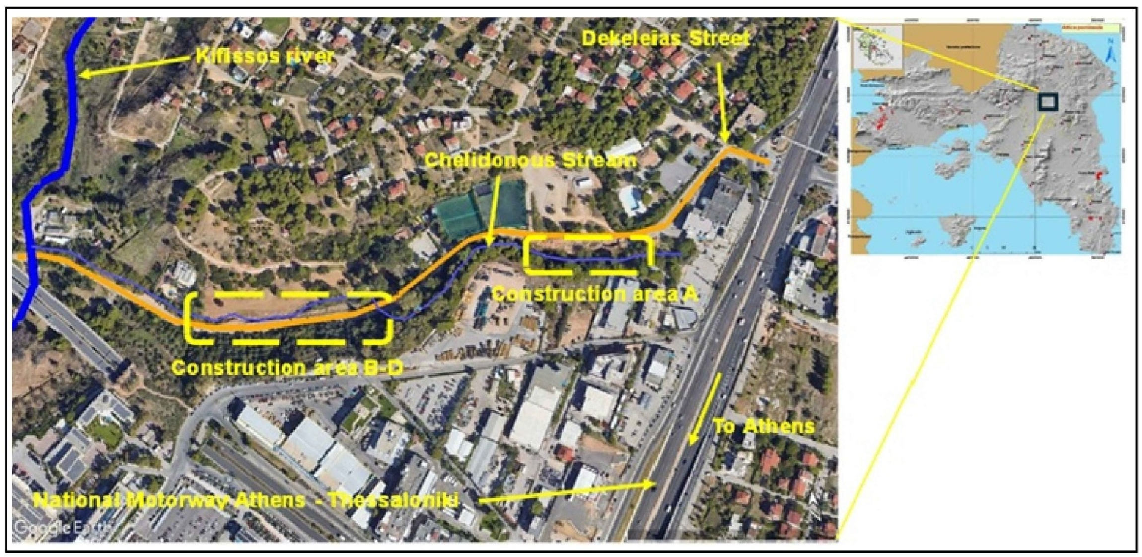
Figure 2.
View from one characteristic slope failure (fall) of the examined road (Author’s archive).
Figure 2.
View from one characteristic slope failure (fall) of the examined road (Author’s archive).
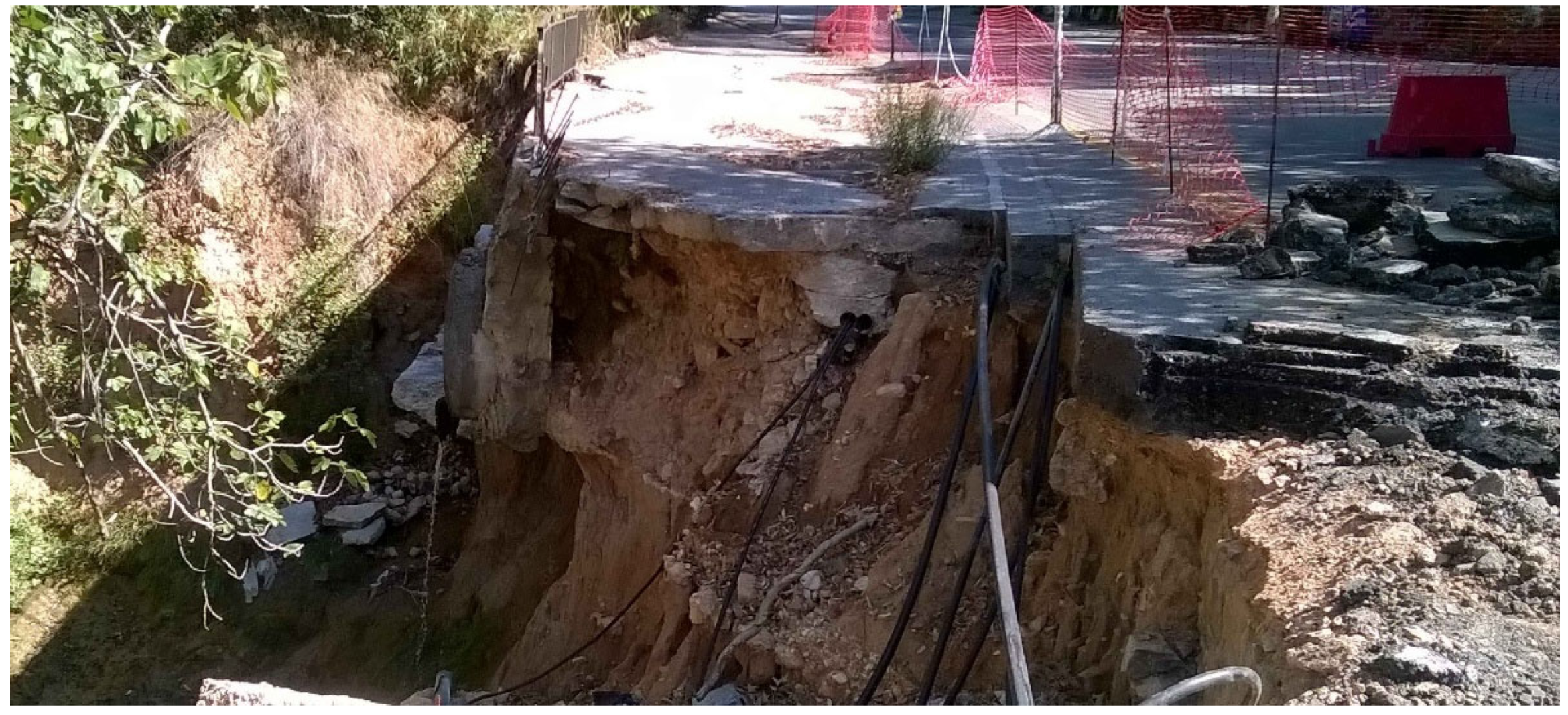
Figure 3.
Geological map of the Attica Region [8]. The examined area is indicated by the black semicircle.
Figure 3.
Geological map of the Attica Region [8]. The examined area is indicated by the black semicircle.
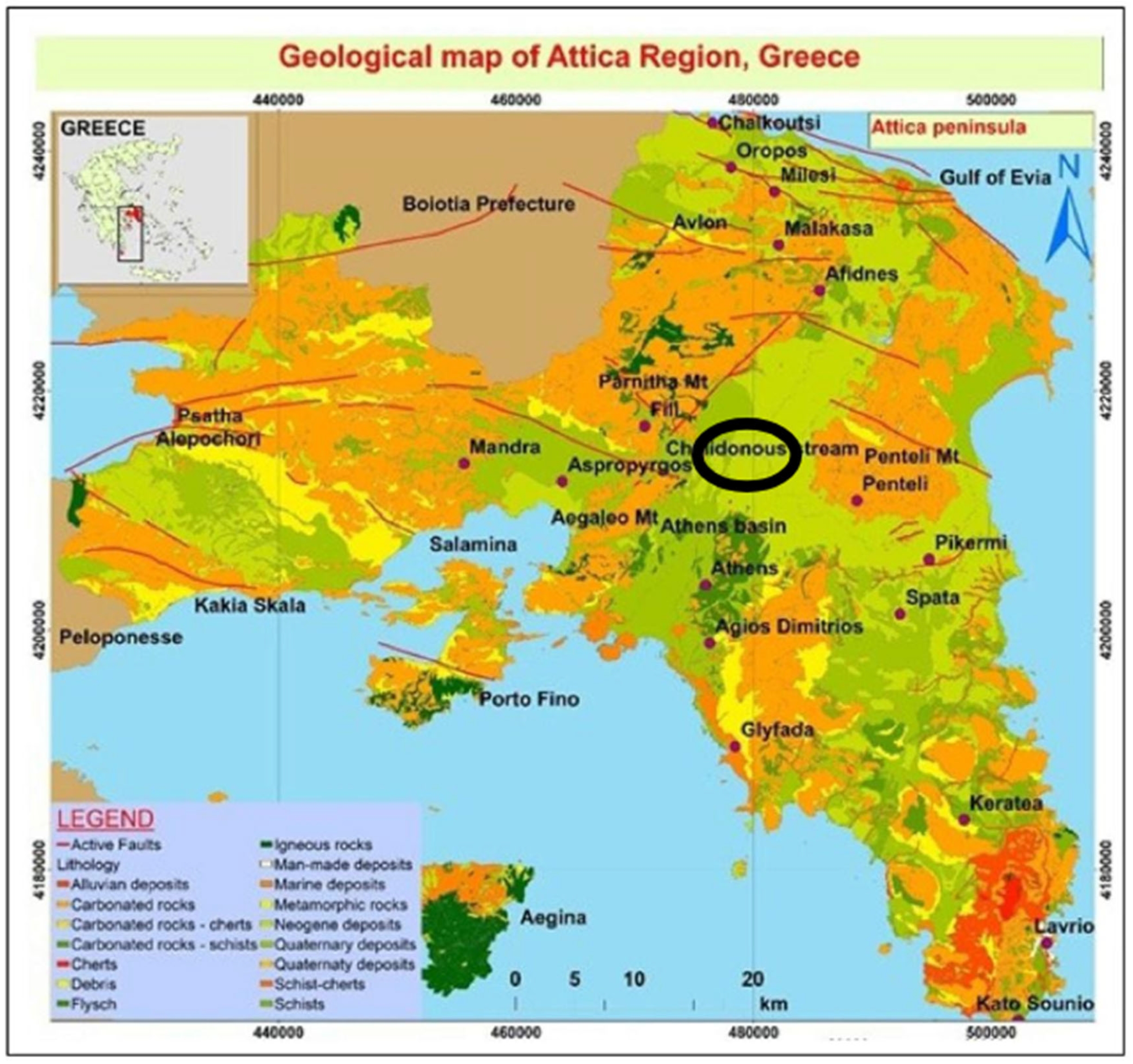
Figure 4.
(a) Borehole drilling, (b) part of the borehole findings (Sand to Clayey geomaterial) is depicted [6].
Figure 4.
(a) Borehole drilling, (b) part of the borehole findings (Sand to Clayey geomaterial) is depicted [6].
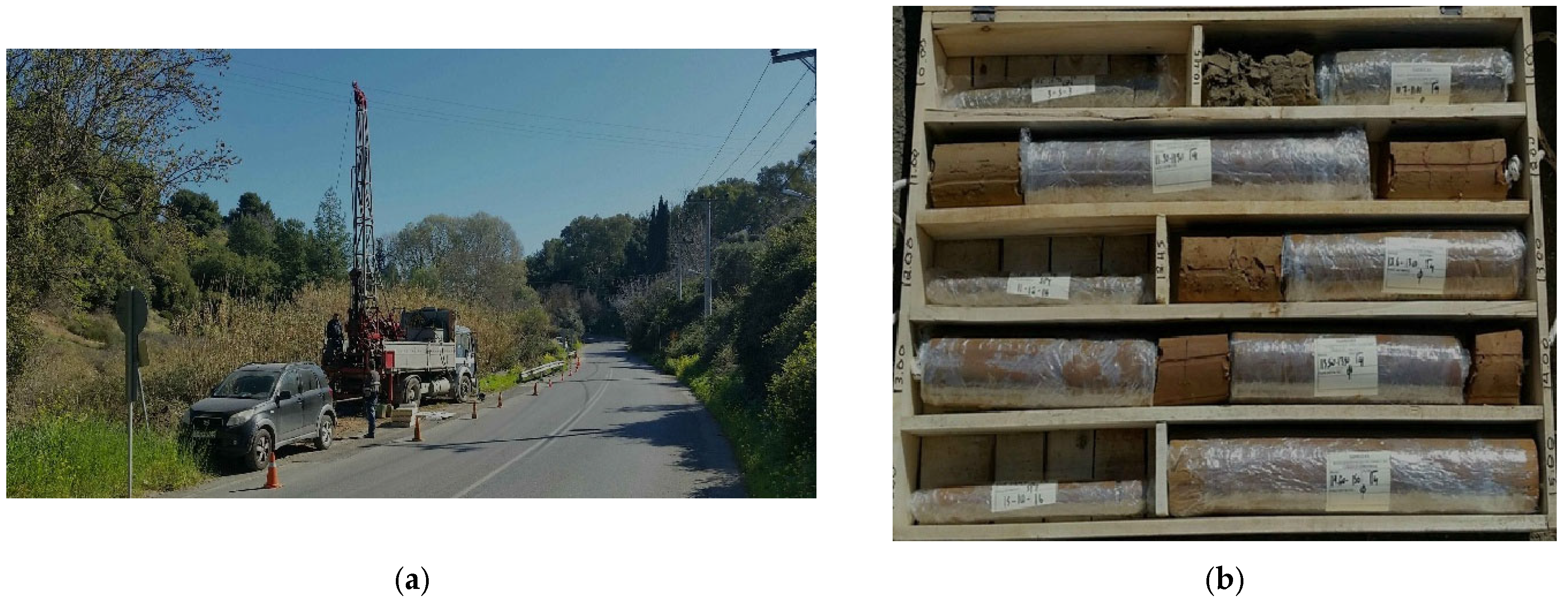
Figure 5.
Visualization of the division of the study area into subareas A to D on a satellite image (source: Google Earth).
Figure 5.
Visualization of the division of the study area into subareas A to D on a satellite image (source: Google Earth).
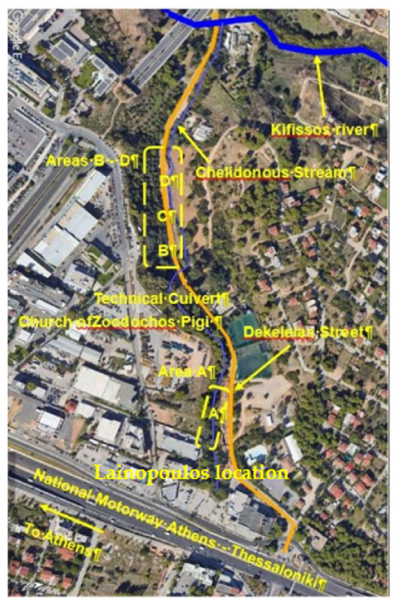
Figure 6.
Views from Area A construction: (a) cutter bar machine, (b) pile walls made of intersecting piles (Author’s archive).
Figure 6.
Views from Area A construction: (a) cutter bar machine, (b) pile walls made of intersecting piles (Author’s archive).
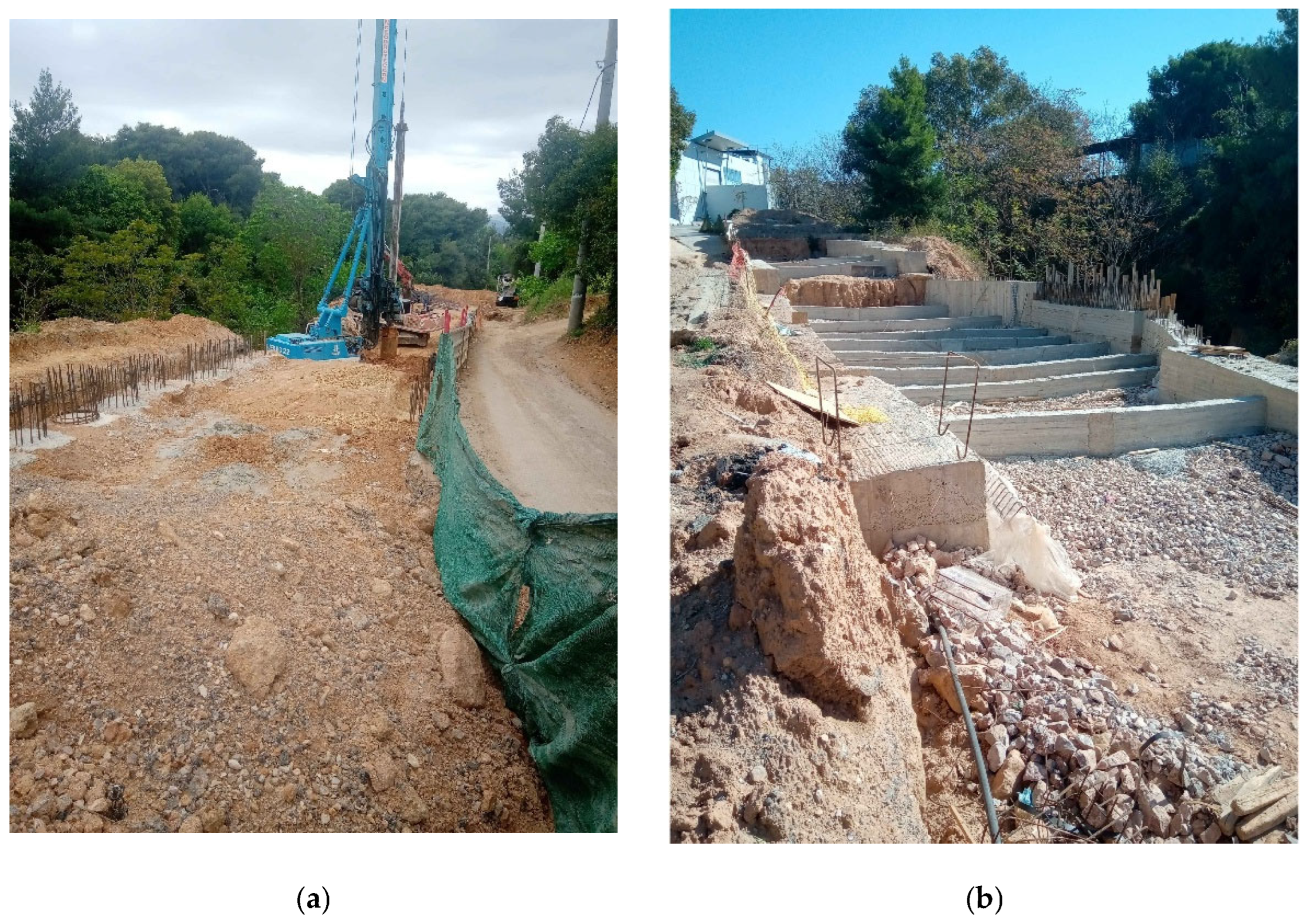
Figure 7.
(a-g). Different successive steps of pile wall construction of areas B to D (Author’s archive). In Figure (e), a view from the drainage system (for lowering the potential pore water pressures and accomplishing adaptation to possible disruption from heavy rainfall episode) is depicted. Figure (g) is associated with the accomplishment—end of the technical works on September of 2023 in the examined segment of the road (Author’s archive).
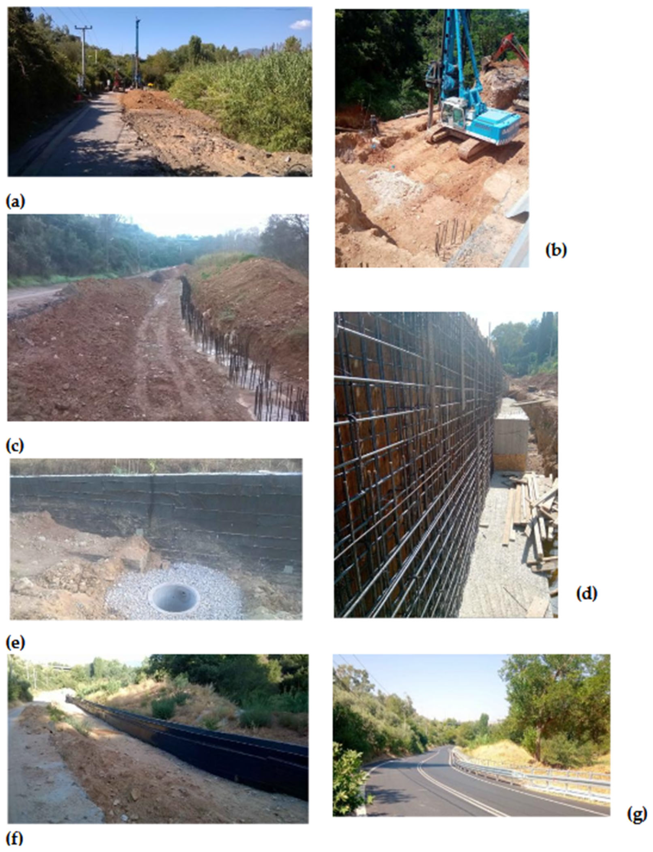
Figure 8.
Typical loss of resilience over time (Lee, 2016). a. The term of resilience for infrastructure [16].
Figure 8.
Typical loss of resilience over time (Lee, 2016). a. The term of resilience for infrastructure [16].
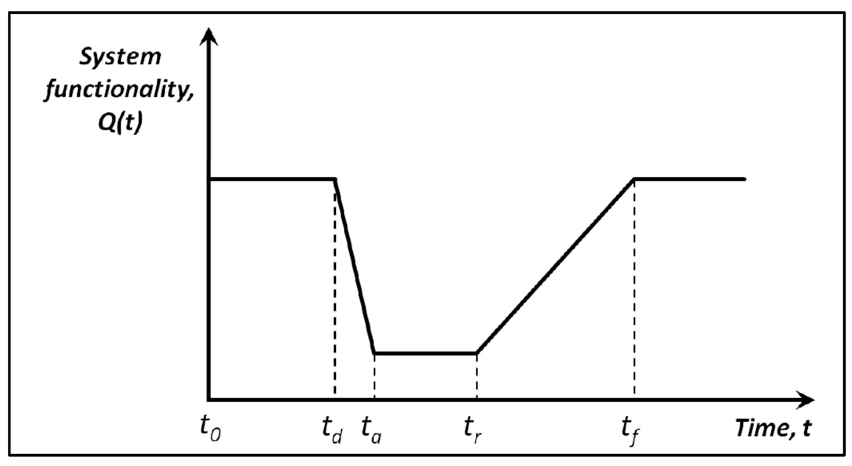
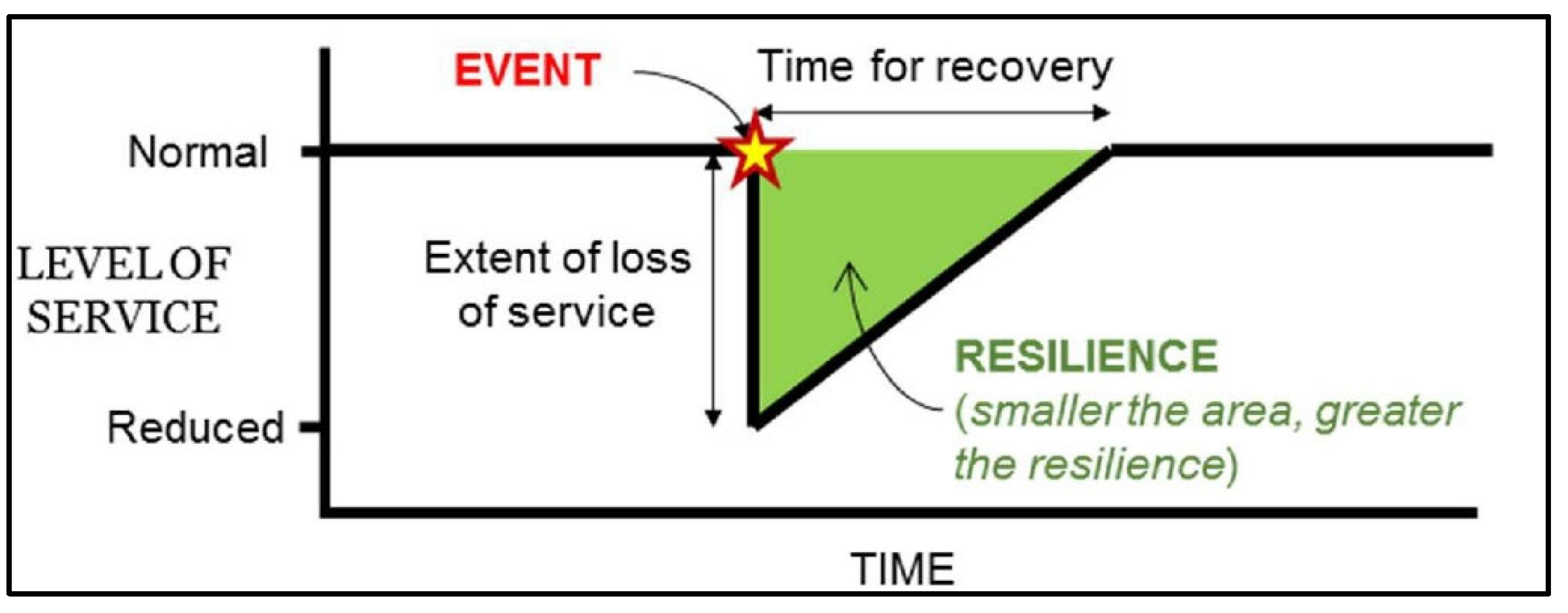
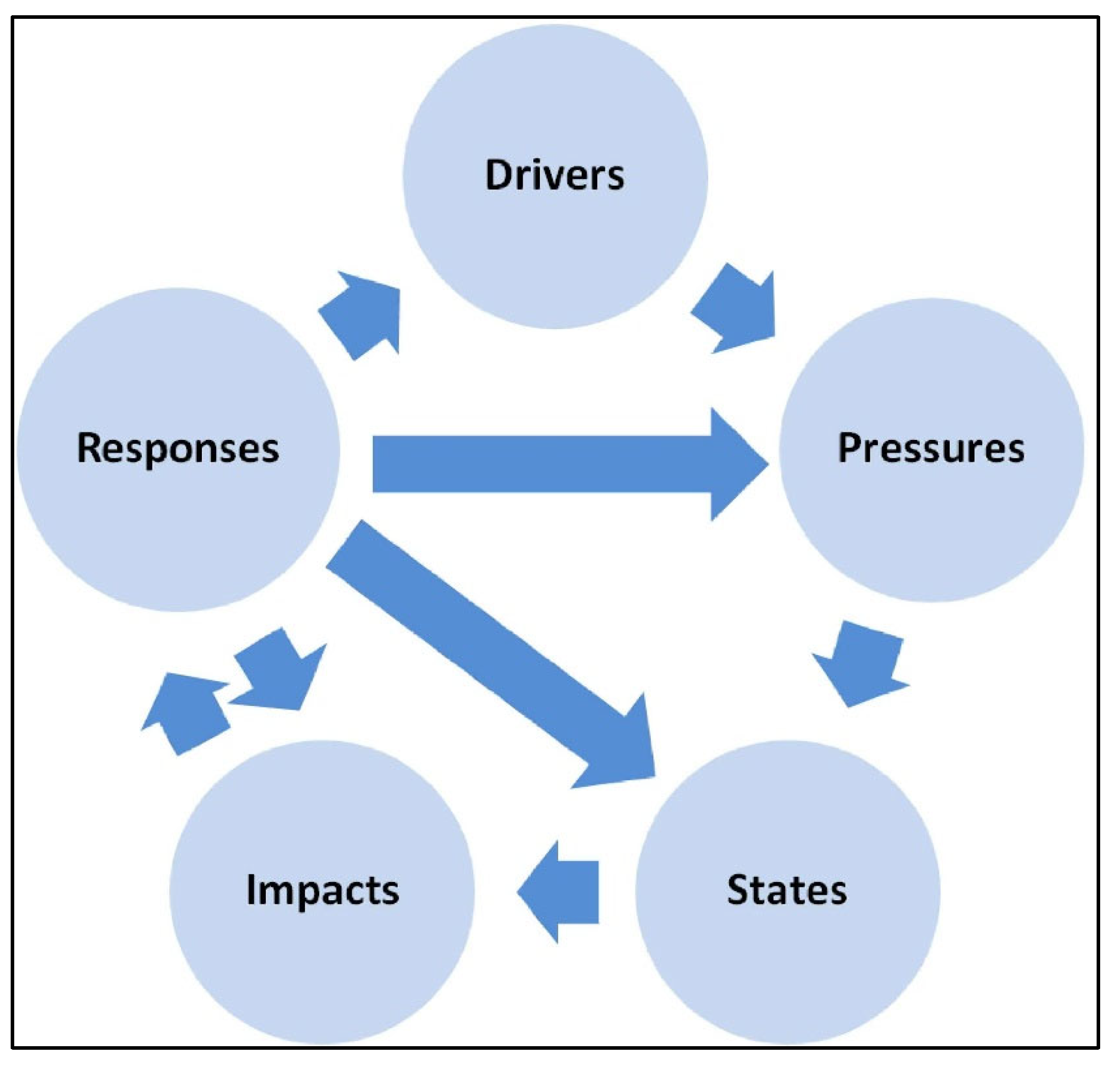
Figure 10.
Basic idea of RES [21].
Figure 10.
Basic idea of RES [21].
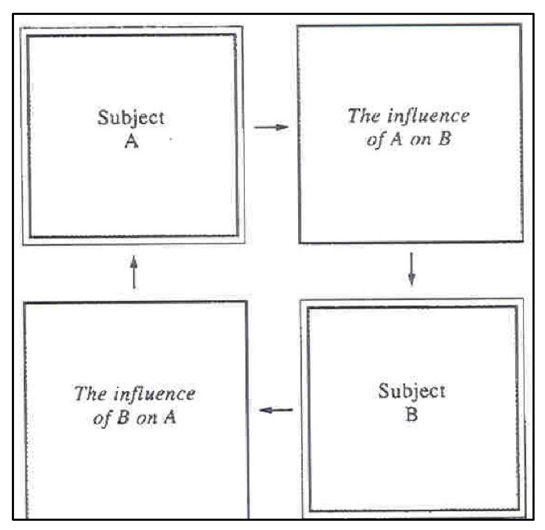
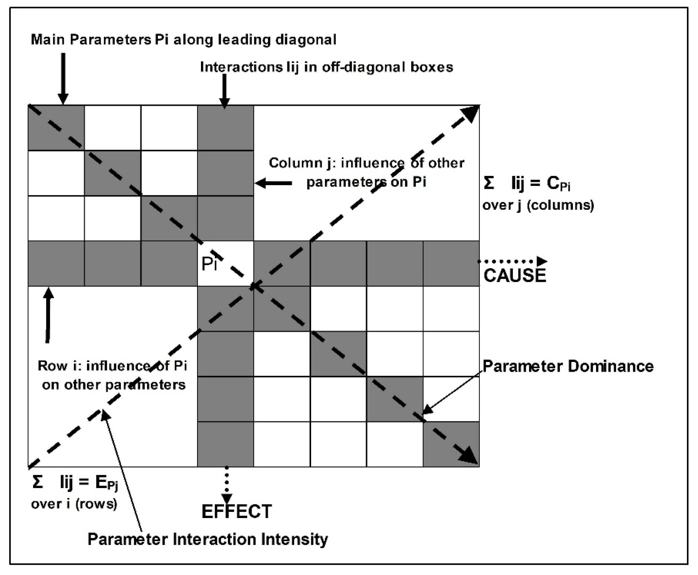
Figure 12.
The performance of the resilience index of the examined segment of Provincial Road 3 from the beginning of the significant failure (2015), through the study (2018), the reconstruction-restoration works (2020-2022) till the end of the restoration technical works (2023).
Figure 12.
The performance of the resilience index of the examined segment of Provincial Road 3 from the beginning of the significant failure (2015), through the study (2018), the reconstruction-restoration works (2020-2022) till the end of the restoration technical works (2023).
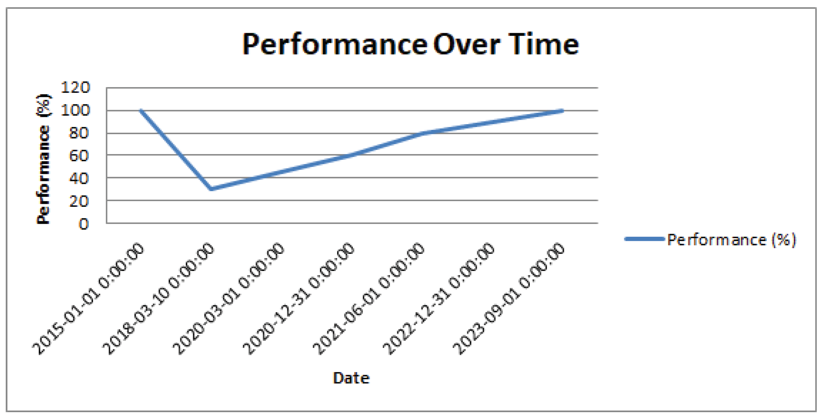

Table 1.
The selected parameters and their rating.
| PARAMETERS | RATING | PARAMETERS | RATING |
|---|---|---|---|
| 1. Distance from roads | 6. Hydrogeological conditions | ||
| Distant (>200m) | 0 | No geomechanically action of water | 0 |
| Moderately distant (151-200 m) | 1 | Fractured formations characterized by almost zero to low permeability (Flysch, schists) | 1 |
| Immediate (101–150 m) | 2 | Alluvial deposits, carbonate formations of low to moderate permeability | 2 |
| Less immediate (51–100m) | 3 | Debris of moderate permeability | 3 |
| Close (0-50m) | 4 | Medium to high permeability Carbonate formations | 4 |
| 2. Tectonic regime | 7. Precipitation | ||
| Weak: associated with the near absence of significant tectonic events | 0 | <400mm | 0 |
| Medium: associated with the presence of scaling, fissuring and splittiing | 1 | 400-600mm | 1 |
| Strong: associated with the presence of folds, cracks and discontinuities. | 2 | 600-1000mm | 2 |
| Very strong: linked with the presence of fragmented zones | 3 | >1400mm | 3 |
| Intense: represents up thrusts and over thrusts | 4 | 1000-1400mm | 4 |
| 3. Slope’s inclination | 8. Vegetation | ||
| 0-5o | 0 | No vegetation (Urban area) | 0 |
| 6-15o | 1 | Zero vegetation | 1 |
| 16-30o | 2 | Moderate vegetation | 2 |
| 31-45o | 3 | Agricultural cultivation | 3 |
| >45o | 4 | Intensive farming | 4 |
| 4. Slope’s orientation (aspect) | 9. Distance from streams | ||
| 225o–275o | 0 | Distant (>200m) | 0 |
| 45o–90o | 1 | Moderately distant (151-200 m) | 1 |
| 90o–135o, 275o–315o | 2 | Nearby (101–150 m) | 2 |
| 315o–0o | 3 | Very close (51–100m) | 3 |
| 0o–45o, 135ο–225ο | 4 | Direct (0-50m) | 4 |
| 5. Lithology | 10. Distance from tectonic elements | ||
| Volcanic rocks | 0 | Distant (>200m) | 0 |
| Cherts, schists, Limestone, marbles | 1 | Moderately distant (151-200 m) | 1 |
| Metamorphic rocks | 2 | Nearby (101–150 m) | 2 |
| Old disturbed landslide geological materials / Neogene | 3 | Very close (51–100m) | 3 |
| Flysch | 4 | Direct (0-50m) | 4 |
Table 2.
Modified Rock Engineering System (RES) approach of the examined Dekeleias road.
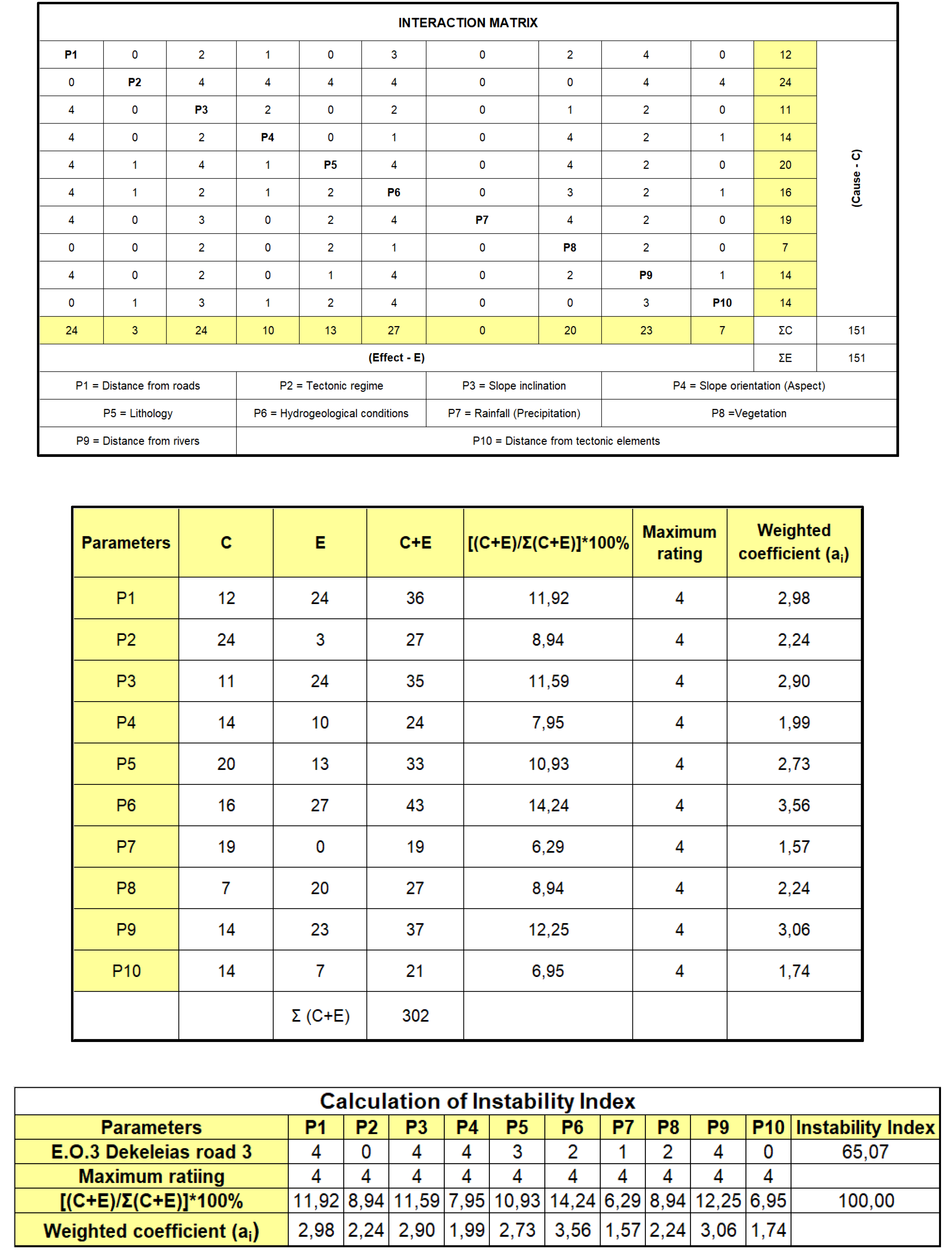
Table 3.
Classification for relative landslide susceptibility proposed by Brabb [24]—Correlation with instability index.
Table 3.
Classification for relative landslide susceptibility proposed by Brabb [24]—Correlation with instability index.
| % Failed area | 0–1 | 2–8 | 9–25 | 26–42 | 43–53 | 54–70 | 100 |
|---|---|---|---|---|---|---|---|
| Relative Susceptibility | I | II | III | IV | V | VI | L |
| Negligible | Low | Middle | High | Very high | Extremely high | Landslide |
Table 4.
Resilience Matrix Template.
| Technical | |||||||
| Environmental | |||||||
| Social | |||||||
| Economic | |||||||
| Preparation | |||||||
| Absorption | |||||||
| Recover | |||||||
| Adaption |
Table 5.
Resilience Matrix after the restoration of Provincial Road 3. Calculation of Resilience Index.
Table 5.
Resilience Matrix after the restoration of Provincial Road 3. Calculation of Resilience Index.
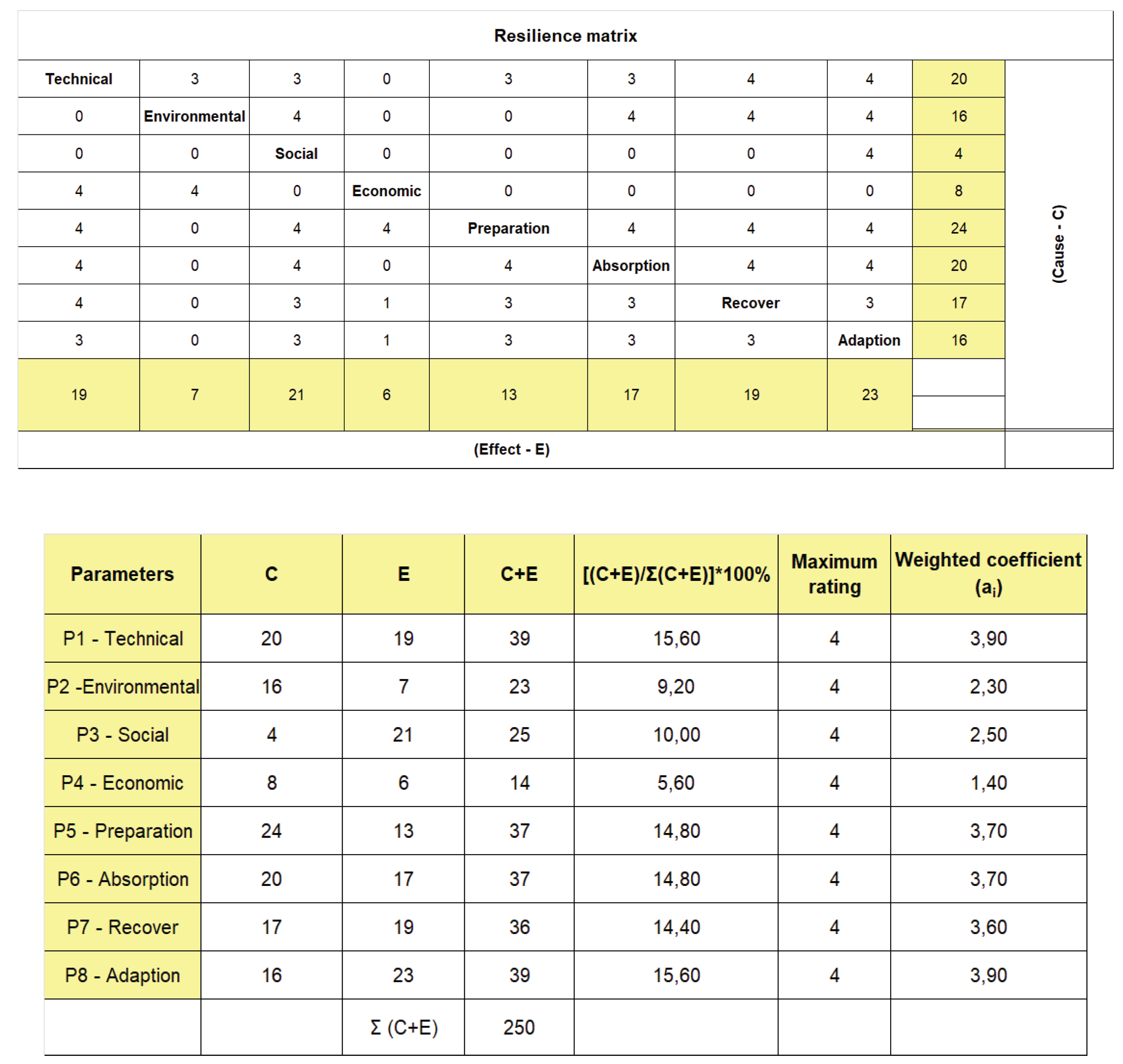
Table 6.
Description of high, moderate and low disaster resilience index for Australian Disaster Resilience Index (ADRI) [26].
Table 6.
Description of high, moderate and low disaster resilience index for Australian Disaster Resilience Index (ADRI) [26].
| ADRI Band | Percentile | Description |
|---|---|---|
| Low | <25th percentile ADRI = 0–0.5215 |
Communities in areas of low disaster resilience may be limited in their capacity to use available resources to cope with adverse events and are limited in their capacity to adjust to change through learning, adaptation and transformation. |
| Moderate | 25th–75th percentile ADRI = 0.5216–0.7110 |
Communities in areas of moderate disaster resilience have some capacity to use available resources to cope with adverse events and some capacity to adjust to change through learning, adaptation and transformation. |
| High | >75th percentile ADRI = 0.7111–1 |
Communities in areas of high disaster resilience have enhanced capacity to use available resources to cope with adverse events and enhanced capacity to adjust to change through learning, adaptation and transformation. |
Disclaimer/Publisher’s Note: The statements, opinions and data contained in all publications are solely those of the individual author(s) and contributor(s) and not of MDPI and/or the editor(s). MDPI and/or the editor(s) disclaim responsibility for any injury to people or property resulting from any ideas, methods, instructions or products referred to in the content. |
© 2025 by the authors. Licensee MDPI, Basel, Switzerland. This article is an open access article distributed under the terms and conditions of the Creative Commons Attribution (CC BY) license (http://creativecommons.org/licenses/by/4.0/).
Copyright: This open access article is published under a Creative Commons CC BY 4.0 license, which permit the free download, distribution, and reuse, provided that the author and preprint are cited in any reuse.


