

Submitted:
04 July 2025
Posted:
07 July 2025
You are already at the latest version
Abstract
Debris flows are rapid mass movements of water-laden debris that flow down mountainsides into valley channels and eventually settle on valley floors. The risk of debris flows can be significantly increased after wildfires. Following the destructive 2021 debris flows in Glenwood Canyon, the Colorado Geological Survey (CGS) initiated a LiDAR-based alluvial fan mapping project to improve geologic hazard delineation of alluvial and high-angle fans in response to developing wildfire-ready watersheds. These landforms, shaped by episodic sediment-laden flows, pose significant risks and are often misrepresented on conventional geologic maps. CGS delineated fan-shaped landforms with improved precision using 1-meter resolution LiDAR-based DEMs, DEM-derived terrain metrics, hydrologic analysis, and geospatial analysis tools within the ArcGIS Pro platform. Our results reveal previously unmapped or misclassified alluvial or high-angle fans in areas undergoing increasing development pressure, where low-gradient terrain indicates a high hazard potential. This work highlights the critical role of high-resolution LiDAR data, geospatial analytical techniques, and systematic QA/QC protocols in refining hazard awareness. The resulting dataset supports proactive land-use planning and wildfire resilience by identifying areas prone to debris flow and flood hazards. Although not intended for site-specific design, these maps serve as a critical resource for prioritizing geologic evaluations and guiding mitigation planning across Colorado’s wildfire-affected landscapes.
Keywords:
alluvial fans
; high-angle fans
; post-wildfire debris flows
; LiDAR-based terrain mapping
; geologic hazard delineation
; fan morphology classification
; slope threshold analysis
; hazard mitigation planning
; ArcGIS pro workflows
; DOGAMI
1. Introduction
1.1. Background
Debris flows often occur after heavy or intense rainfalls in burned areas, where soil becomes more vulnerable to erosion, biodegradation, and hydrophobicity once vegetation has been removed. Wildfires can substantially elevate the risk of post-fire debris flows [1,2,3,4]. Recent catastrophic debris flows in Colorado, particularly those in Glenwood Canyon and nearby regions, following the 2020 Grizzly Creek Fire [4], have highlighted the limitations of existing geologic hazard maps, especially concerning alluvial and high-angle fans. These sediment-rich, fan-shaped deposits are common at mountain valley outlets and are prone to debris flows, mudflows, and flooding hazards, often exacerbated after wildfires. Many affected properties were built atop seemingly flat landforms, underscoring the disconnect between perceived and actual risk [5]. With increased fire severity linked to climate change, understanding and mapping alluvial and high-angle fans are critical for land-use planning and hazard mitigation. This LiDAR-based alluvial fan (LAF) mapping project outlines a methodology for enhancing fan delineation using high-resolution LiDAR-based digital elevation models (DEMs) and DEM-derived terrain maps, as well as GIS-based terrain and hydrologic analyses. It emphasizes the importance of mapping accuracy, the need for updating existing geologic maps, and post-fire readiness, thereby building a dataset for proactive geohazard response across Colorado’s wildfire-prone regions.
Alluvial fans are semi-conical depositional landforms formed where sediment-laden streams emerge from confined valleys into a relatively open, flatter plain [6,7]. In contrast, high-angle fans have a much steeper slope than a typical alluvial fan. They can form through both water-transported alluvium and mass wasting processes, such as landslides. These geomorphic features are formed by the deposition of sediment transported through fluvial systems. Understanding the interaction between alluvial fans and their fluvial system, such as connected stream channels and basin pour points, is essential for hazard assessments, hydrological modeling, and sediment transport analysis [8,9]. Channels deliver sediment to fans, influencing their geomorphic evolution and potential hazards, such as debris flows or flooding. Figure 1 provides a schematic illustration of a typical alluvial fan in mountainous terrain, used to understand sediment transport and deposition in arid to semi-arid environments. Mapping alluvial and high-angle fans plays a key role in hazard assessment, land-use planning, and geomorphic mapping of the mountain and foothill landscapes [10,11].
At the top of the system, runoff collects within a defined basin, where tributary channels converge to form a main drainage pathway. These tributaries, flowing between ridges, transport water and sediment down the slope. As the main channel reaches the mountain front, it exits the confined terrain and reaches the apex of the alluvial fan, marked in the diagram (Figure 1) by a red dot. This apex is the transition point from erosion and transport to deposition. Beyond this point, the channel loses energy and disperses across a broader, low-gradient surface, depositing sediment in a fan-shaped pattern that defines the alluvial fan. The fan surface extends downslope to its distal edge, known as the toe of the fan, where finer materials settle and transport generally ceases. Below the surface, layers of alluvium represent these accumulated sediments. Notably, Figure 1 also highlights a mountain front active fault, which influences regional uplift, drainage incision, and sediment delivery to the fan [10]. Together, these components portray the dynamic interplay between tectonics, fluvial processes, and sediment deposition in shaping alluvial fan landscapes [6,7].
GIS (Geographic Information Systems) offers essential tools for mapping alluvial and high-angle fans, supporting hazard assessment, planning, and resource evaluation [4,5,9,10,11,12]. These tools enable the pre-processing of LiDAR-based DEMs, terrain and hydrology analyses, and the identification of fan apexes, as well as the delineation of the lateral margins and distal edges of fan deposits. Additionally, they facilitate the integration of other relevant spatial data, such as land use and zoning. ArcGIS Pro 3.3 or 3.4 serves as the primary platform used for this project.
1.2. Study Sites and Focus Areas
The focus areas for this project are directly related to regions experiencing high development pressure and land use needs, as well as areas with heightened wildfire risk in western Colorado. As of Spring 2025, Figure 2 denotes the counties that have completed LAF mapping (Phase 1) and are in process for 2025 completion (Phases 2 and 3). Other counties are scheduled for completion in 2026. The CGS and the Colorado Water Conservation Board (CWCB), under the Colorado Department of Natural Resources (DNR), collaborate to identify high-risk areas based on the current stakeholders’ needs.
1.3. Geomorphology and Geologic Maps of Colorado.
Colorado showcases a diverse array of geomorphic features that reflect its rich geology and extensive history of surface processes. The landscape, ranging from the relatively flat eastern plains to the high mountains and deep canyons, is shaped by multiple factors, such as glaciation, fluvial processes, wind, and weathering.
Geomorphology informs us about how sediment is transported, deposited, and reworked across a landscape. At the same time, geologic maps provide insight into the material composition, structural controls, and long-term processes shaping landform evolution. Understanding the geomorphic context and underlying geology is essential for accurately delineating alluvial and high-angle fans as well as for assessing hazards.
Figure 3 shows the 1:24,000-scale 7.5-minute quadrangles in Colorado, some of which extend across state borders into Wyoming, Utah, New Mexico, Nebraska, Kansas, and Oklahoma. In total, there are approximately 1,942 quadrangles, with just over 700 of these mapped. These include 382 mapped by the United States Geological Survey (USGS) and 321 mapped by CGS. These geologic maps provide critical baseline data for interpreting the genesis of landforms, subsurface conditions, and hazard susceptibility. Where geologic mapping is not yet available, LiDAR-based mapping and terrain analysis provide a foundational dataset for identifying priority zones and initiating further geologic investigations.
Figure 4 illustrates an example of a previously unmapped alluvial fan that was identified and validated in this LAF project. Figure 4a illustrates a portion of the Geologic Map of the Breckenridge Quadrangle [13], Summit and Park Counties, Colorado. This area includes colluvial and landslide deposits (Qls, Qc) directed downslope to alluvium (Qal) deposits. Figure 4b shows the LiDAR-based alluvial fan mapped from this LAF mapping project, depicted in purple, situated downslope of incised colluvial and landslide deposits (Qls, Qc), and is mapped within alluvium (Qal) deposits. The geology map distinguishes between depositional units, including alluvium (Qal), colluvium (Qc), and landslide deposits (Qls), each of which influences sediment sourcing and fan formation. This upstream sediment source zone supports the interpretation of fan landforms and helps identify areas susceptible to future debris flows or sediment reactivation, which acts as a sediment source. Figure 4c illustrates the alluvial fan polygon overlain on the digitized geologic map.
Geologic maps often depict alluvial fan deposits. However, in some instances, geologic mapping focuses on interpreting the deposit, rather than the landform itself. Additionally, previously published geologic maps were created before the emergence of geospatial technology, such as LiDAR-based mapping products and high-resolution DEMs, which are readily available for present-day geologists. While geologic mapping can depict alluvial fan deposits, LiDAR-based alluvial fan mapping has become a critical approach for identifying fans more precisely and extending the mapped areas compared to previous efforts, where fans were only partially mapped. Figure 5 shows an example of partially mapped alluvial fans from the Geologic Map of the Harvard Lakes Quadrangle [14], overlain by a fully mapped alluvial fan using LiDAR-based and LiDAR-derived datasets and the methodology discussed in this study.
These geologic and geomorphic datasets collectively support a more integrated, landscape-scale approach to hazard mapping. By superimposing high-resolution LiDAR-based map products with detailed geologic units and structural data, this project enhances the accuracy of fan mapping, improves hazard readiness, and informs decisions related to development, infrastructure siting, and post-fire risk mitigation in Colorado’s mountainous terrain.
1.4. Geologic Hazards Associated with Alluvial and High-Angle Fans
Alluvial fans are part of a complex sediment transfer process that involves the source area, the apex of the fan, and the fan itself (see illustration in Figure 6). These processes include erosion, incised channel development, and deposits from mudflows, debris flows, and hyperconcentrated flooding events. Incised channels primarily result from erosive flows from the source area. Debris flows can alter the location of incised channels due to channel-switching (avulsion) dynamics at the apex of the fan associated with these events. The entire alluvial fan is at varying risk of debris flows, mudflows, flooding, and erosion. When planning development within or near alluvial fan areas, site-specific evaluation should consider the depth of flooding, the potential for mudflow or debris flow deposits, the velocity and height of these events, as well as the depth of sheet flow flooding.
The risk of flooding and debris flow hazards can lead to the destruction of buildings and fatalities. Changes in the source area (due to landslides, avalanches, flooding, etc.) increase the probability of flooding or debris flow. A wildfire in the source area that feeds the alluvial fans will significantly increase the sediment load and intensify a debris flow event.
In summary, alluvial and high-angle fans are areas susceptible to various geologic hazards, including flooding, mudflows, debris flows, sediment deposition from hyperconcentrated flooding (characterized by high sediment yield), and erosion. In addition, alluvial fans can have hydrocompactive soils (collapsible soils) prone to volume decreases when saturated with water. Intermittent high groundwater is also a common feature of alluvial fans.
2. Materials and Methods
2.1. Overview
Alluvial and high-angle fan landforms were mapped using 1-meter-resolution LiDAR-based data from the Colorado Water Conservation Board (CWBC) under the Colorado Department of Natural Resources (DNR). This study employed a multi-step geospatial workflow to delineate alluvial fans in mountainous regions of Colorado using high-resolution LiDAR DEM data, DEM-derived terrain maps, hydrologic analysis, and hydro-geomorphic principles (such as the associations between hydrography and geomorphology) to support hazard assessments for post-wildfire debris flow and flooding as part of the Wildfire Ready Watersheds initiative.
This LAF mapping project intends to identify and map the extent of fan landforms to a new level of accuracy. This includes interpretations where anthropogenic activities have altered the fans (such as roadcuts, housing developments, and human-made drainage ditches). The methods for identifying fans from the available LiDAR imagery consist of several steps, which are illustrated in Figure 7.
As outlined in Figure 7, mapping utilized ArcGIS Pro workflows including hillshade analysis, slope and classified slope maps, 0.6- to 1.5-m (2- to 5-ft) contours, and convolution filters to detect areas of steep slopes with confined stream channels. The fan landforms were digitized using a slope threshold of ≤20° for alluvial fans and >20° for high-angle fans. Channel lines, catchment boundaries, and aerial imagery (e.g., Esri World Imagery, Google Earth, Wayback imagery) were used to support the placement of polygons. Distal fan edges were constrained by proximity to significant drainages or at slopes of <2°, as defined by the slope angle threshold for the toe of the fan. Furthermore, Quality Assurance and Quality Control (QA/QC) protocols included a random cross-review of 10% of polygons with adjustments for development impacts, and a cross-mapper review to identify any inconsistencies in the mapping process. Field checks were conducted where access permitted, focusing on areas of human activity and recent hazard exposure. Alluvial and high-angle fans of <2000 m2 in area were excluded to maintain map scale integrity (1:24,000).
2.2. Data Acquisition
The LiDAR-based alluvial fan mapping project utilizes superimposed datasets in ArcGIS Pro, comprising geospatial datasets derived from sources such as the USGS, CGS, and CWCB (see Table 1 for more details).
2.3. Criteria and Mapping
Alluvial fans were delineated based on a suite of topographic and morphometric indicators derived from high-resolution elevation data. Key criteria included:
- Cone-Shaped Morphology: Fans exhibit a classic conical shape, often characterized by a radial pattern in contour lines indicating outward spreading from a central apex.
- Feeder Channels: Channels were identified at the mountain front, where confined streams transition to unconfined deposition zones, serving as the primary sediment source for fan formation.
- Slope Characteristics:
- ○
- Apex Gradients: Steep slopes near the apex mark the depositional transition from confined flow to distributary patterns.
- ○
- Distal Edge Gradients: Gradual slopes at the fan’s toe, typically less than 2°, define the distal termination of the fan (Figure 8a).
- ∉
- Average Slope:
- ○
- Alluvial Fans: Exhibit an average slope of less than or equal to 20°, consistent with depositional landforms.
- ○
- High-Angle Fans: Identified where average slopes exceed 20°, often indicating more confined or steeper depositional environments.
- ∉
- Convolutionally Filtered Slope
- ○
- A circular focal statistical analysis or convolution filter is applied to the slope map to detect areas of steep slope with confined stream channels from the areas of valley plain (Figure 8b).
2.4. Digital Terrain Processing
A suite of terrain derivatives was generated from the LiDAR-based DEM using functions in ArcGIS Pro to support landform identification. These included slope, classified slope, hillshade, curvature, contour lines, and slope by convolutional filter, each providing complementary information on surface morphology and gradient transitions. To enhance the recognition of geomorphic boundaries, the convolution-based focal statistics filter was applied to the DEM-derived slope map (Figure 8b). This tool computed localized slope variability across defined neighborhoods, effectively highlighting slope discontinuities and aiding in delineating transitions from confined, channelized flow paths to unconfined depositional zones characteristic of alluvial fans.
2.5. Hydrology Analysis Using DOGAMI
DOGAMI Debris Flow Hazard ArcPRO Toolbox (https://pubs.oregon.gov/dogami/sp/SP-53/p-SP-53.htm) [15]. The Colorado Geological Survey developed two Python-scripted toolboxes based on DOGAMI’s hazards generator toolbox to obtain base maps, initiation and transport, basins, and channel transport potential based on channel confinement and gradient. Refer to the DOGAMI Protocol for Channelized Debris Flow Susceptibility Mapping [15].
Based on DOGAMI’s Debris Flow Hazard Tool and refined by CGS using a Digital Elevation Model (DEM), the Channel dataset is a polyline shapefile that represents connected channels contributing sediment and water to feed the fans. This dataset incorporates detailed hydrological analyses, including flow direction, flow accumulation, and stream order, to comprehensively represent the catchments and channel network. Specifically, the tool determines the flow direction to identify the path of water movement across the terrain, calculates flow accumulation to pinpoint areas where water converges, indicating potential debris flow channels, and delineates the stream network using thresholds that vary based on the resolution of the DEM and other region-specific factors. This helps to define stream networks and highlights primary channels that are susceptible to debris flows.
2.6. Fan Delineation Workflow
Apex Identification: Located at the junction of confined valleys and depositional plains, marked by abrupt slope changes and channel exit points.
Lateral Boundary Tracing: Using slope flattening patterns, lateral spreading, and contour divergence, the lateral margins were manually delineated.
Distal EdgeTracing: Using slope flattening patterns and contour divergence, the distal edge was manually delineated.
Imagery and Map Verification: Fan outlines were cross-referenced with aerial imagery, historic topographic maps, and the Geologic Map (if available) for confirmation.
Alluvial and high-angle fans are significant geological landforms characterized by their fan or cone shape, created by sediment accumulation at the outlets of canyons or valleys. Their geomorphology (including shape and structure) and hydrology, which involves water processes, are interconnected and influence each other. In a broader sense, delineating fans should also include terrain analysis, surface geologic mapping, and hydrology analysis alongside fan delineations, as shown in Figure 9. The fan delineation workflow also includes QA/QC and field-check processes, which provide feedback for revisions of the maps. These processes are iterative before the maps are stored in geodatabases and shared with the stakeholders and the general public.
2.7. QA/QC Protocol
To ensure data accuracy and consistency, Quality Assurance and Quality Control (QA/QC) have been conducted systematically throughout the project. This process is crucial because GIS data is often the foundation for multi-criteria decision making, and erroneous or even inaccurate data can be misleading in development planning and hazard mitigation.
Ten percent of the initially digitized fan polygons were randomly selected and reviewed by a different mapper. The location of the fan apex, the fan shape, and the distal edge were closely examined. Furthermore, any alterations to the fans caused by anthropogenic activities were noted. The supporting maps for the review included the stream flowlines, the catchment map, the slope map, and a convolutional filter that separated the steep slope with the confined stream channel from the alluvial plain. If necessary, the fan polygons were adjusted based on the feedback from the review. A second, different mapper conducted another round of cross-mapper review.
QA/QC is crucial for minimizing errors, ensuring data quality, and meeting the needs of stakeholders. As a result, it allows the created dataset to be effectively utilized in analysis, planning, and decision-making.
3. Results
3.1. Summary of the Results as of June 2025
The CGS LAF mapping project has finished and published the first iteration (Version 1) of datasets for six counties (Table 2), with a few more counties currently undergoing QA/QC and internal review. Preliminary mapping in six counties delineated over 3,200 alluvial and high-angle fan polygons. Highlights for a couple of these counties are further discussed in Section 3.2 and Section 3.3.
The project identified many fans not previously included in geological hazard inventories and reclassified several misidentified landforms. Following the identification of the alluvial fan landforms within the project focus areas and using the data sources described previously, a series of field checks was conducted at many selected locations. The primary purpose of the ground-truthing was to verify geomorphic characteristics and features observed in mapping and confirm fan extents in developed areas, particularly in zones of post-fire debris-flow damage. The field mapping also documented complex depositional zones with mixed colluvial and alluvial signatures, emphasizing the need for integrated classification criteria.
QA/QC reviews led to polygon refinement in over 15% of initial cases, primarily due to anthropogenic modification or stream incision. DEMs and fan slope statistics supported the separation of high-angle fans from conventional fan shapes, informing potential hazard thresholds.
The following sections illustrate the specific results generated from this project using Clear Creek and Pitkin Counties as examples. Clear Creek County and Pitkin County are both within mountainous terrain in Colorado
3.2. Clear Creek County Example
Clear Creek County spans an area of 1,030 square kilometers (396 square miles) and exhibits a diverse geomorphology shaped by its geological history, including mountain building, faulting, uplift, and erosion. Rugged mountains, deep canyons such as Clear Creek Canyon, and various glacial and alluvial sediments characterize the landscape. This region has undergone several episodes of folding and faulting, resulting in the development of distinct rock types and formations. Figure 10 displays a portion of the county with many mapped alluvial fans and a few high-angle fans. The Clear Creek and its tributaries are also shown in the figure.
Figure 11 focuses on the distribution of existing structures across the 81 mapped alluvial fans in Clear Creek County. Building density varies significantly, with counts ranging from 1 to 115 structures per fan. The mean density is 8.96 buildings, but the high standard deviation of 17.11 and a maximum of 115 buildings reflect substantial variability. Most fans have relatively few buildings, with 25% having only one or fewer structures and a median of three. The map visualization (Figure 11a) highlights buildings (orange polygons) located within alluvial fan areas (outlined in pink) and their surrounding terrain. Connected channels (blue lines) emphasize hydrological pathways, while a grayscale hillshade background provides a detailed view of the fan’s topography. A concentration of buildings in the central portion of certain fans suggests significant development in high-risk zones, increasing susceptibility to hazards such as erosion, flooding, and debris flows.
The spatial plot (Figure 11b) illustrates the geographic distribution of buildings within the fan for the entire county using point size and color to reflect building density. Larger, brighter points (yellow-orange) represent fans with higher building counts, while smaller, darker points (purple) indicate fans with fewer structures. Clusters of high-density fans are evident in urbanized areas, whereas sparsely populated fans appear in more isolated regions.
This analysis indicates that fans with high building densities are identified as priority areas for mitigation due to their increased vulnerability to natural hazards. This analysis highlights the significance of integrating building data into hazard assessments and implementing targeted strategies to mitigate risks in developed areas within alluvial fan boundaries. Effective measures may include stricter zoning regulations, infrastructure upgrades, and enhanced community awareness of geomorphic hazards.
3.3. Pitkin County Example
Pitkin County encompasses approximately 973 square miles (2,520 square kilometers) and exhibits a range of geomorphological features shaped by its mountainous terrain, glacial past, and river systems. This region encompasses the Elk Mountains, which include Aspen Mountain and the Roaring Fork River valley. Common geomorphologic studies in the areas include investigating river stability, the effects on wetlands, and risks associated with debris flows after wildfires. Figure 12 displays a portion of the county with many mapped alluvial fans and a few high-angle fans.
Figure 13 shows an image of bajada or coalesced fans in Pitkin County, Colorado. Bajadas are broad, gently sloping landforms formed by the lateral merging of adjacent alluvial fans along the base of a mountain front [11]. As individual fans prograde and expand over time, they coalesce to create a continuous apron of sediment that extends into the basin. Bajadas typically form in arid and semi-arid regions where episodic, high-energy flow events deposit coarse sediment at the mountain front. These landforms are very common and have been identified in all the counties for this project. Unlike single, isolated fans, bajadas represent integrated depositional systems that reflect long-term sediment supply, tectonic controls, and climatic variability.
Figure 14 shows a talus slope (outlined in yellow) along the base of a steep mountain front. Additionally, a major roadway traverses the central portion of the slope, providing a clear example of anthropogenic modification. The construction and grading associated with the road appear to have altered the natural depositional gradient, disrupting surface runoff pathways and potentially redistributing sediment downslope. This human activity complicates geomorphic interpretation and may increase the potential for localized instability or altered debris flow behavior. Such features demonstrate how infrastructure can alter natural slope processes and the importance of incorporating both natural and modified terrain into hazard assessments, particularly in mountainous regions where infrastructure intersects active geomorphic processes.
For each county, notes and descriptions are provided in the attribute tables for each fan, highlighting whether anthropogenic activities, field checks, and other relevant observations were observed or conducted. This information, along with detailed metadata, is essential for providing the user with all the necessary tools for interpreting the dataset.
4. Discussion
This lidar-based mapping effort provides a replicable framework for identifying debris flow-prone areas with improved precision. The separation of alluvial versus high-angle fans using slope-based criteria, combined with convolution filtering and cross-checking protocols, addresses gaps in traditional geomorphic mapping. Such tools are critical for anticipating hazard exposure in rapidly urbanizing or post-fire landscapes. While this dataset is not a substitute for site-specific investigations, it offers a screening-level tool for planners, engineers, and emergency managers. Results also support broader policy efforts to incorporate terrain data into fire recovery and resilience planning.
Geologic mapping, along with terrain, hydology, and geospatial analyses, play essential roles in this LiDAR-based alluvial and high-angle fan mapping project, which integrates high-resolution LiDAR-based DEM, LiDAR-derived terrain metrics (e.g., slope, contour, and slope by convolutional filter maps), hydrologic analysis, spatial analysis tools in ArcGIS Pro, Google Earth Imagery, Wayback imagery, and available geologic mapping to assist in identifying alluvial and high-angle fan landforms.
The CGS prioritizes comprehensive mapping by recognizing and analyzing geological hazards while assessing mineral, energy, and water resources. This project specifically aims to address geological hazards. The CGS geohazards group specializes in evaluating various geological hazards in Colorado. These hazards include landslides, debris flows, mudflows, rockfalls, swelling, and collapsible soils. Geological hazards are prevalent in the mountainous areas of Western Colorado, primarily due to the topography and unique geological formations, such as the weak claystone found in the Morrison Formation and expansive soils derived from shale bedrock.
With the increasing availability of geospatial techniques and high-resolution LiDAR data, the CGS utilizes this information to map faults, assess geothermal potential, and identify geological hazards. This includes the ongoing LiDAR-based alluvial fan mapping project conducted by the geohazards group, which plays a vital role in providing comprehensive geological assessments in Western Colorado. It emphasizes detailed mapping and the identification and evaluation of geological hazards. This dataset is essential for land-use planning, hazard mitigation, and effective resource management in the region.
This study identified many missed or unmapped fans and those only partially mapped in previously published geologic maps. One of the reasons is that previously published geologic maps were created before the emergence of geospatial technology, such as LiDAR-based mapping products and high-resolution DEMs. Another reason is that geologic maps often depict alluvial fan deposits because geologic mapping traditionally focuses on interpreting the deposit, rather than the landform.
Another issue worth discussing in this project is the selection of the mean cutoff slope angle between a talus cone, which belongs to the high-angle fan category, and a debris flow fan, which by nature belongs to the alluvial category. There is little information available in the literature regarding this issue.
The guidelines adopted in this study are as follows [16]. Therefore, high-angle fans (including talus cones) typically have a mean slope greater than 35 degrees with no clear feeder channel, and they are wedge-shaped. In comparison, alluvial fans (including debris flow fans) have a mean slope >20 degrees and usually <35 degrees with a feeder channel present.
- Slope angle: Talus cones are typically 34-37 degrees, close to the angle of repose for loose rock fragments, while debris flow fans can be steeper than talus cones, sometimes approaching the angle of repose.
- Composition: Talus cones are mainly coarse, angular rock fragments ranging from small pieces to large boulders, and debris flow fans have a wide range of particle sizes, including fine-grained soils, coarse debris, and organic materials like trees
- Depositional pattern: For talus cones, larger fragments tend to be found near the toe of the deposit, while smaller particles are more common near the top. Debris flow fans may have a mixed distribution of particle sizes.
5. Conclusions
High-resolution lidar and systematic mapping workflows significantly improve the identification of alluvial and high-angle fans. The LAF method enhances geohazard awareness in fire-impacted areas of Colorado and informs risk mitigation efforts. Continued refinement of classification thresholds and integration with hydrologic models could further advance hazard prediction capacity.
Our findings identify previously unmapped, misclassified, or partially mapped alluvial and high-angle fans in areas with growing development pressure, especially where low-gradient terrain suggests high hazard potential. These results can be used to update existing surficial geologic maps to incorporate these newly identified features.
Alluvial and high-angle fans were categorized according to their average slope: alluvial fans at ≤20° and high-angle fans at >20° but typically < 35°. Their classification also considered hydrological features, such as stream channels and basin pour points, encompassing both traditional and complex geomorphic characteristics. DEM and fan slope data were used to differentiate high-angle fans from typical ones, helping to establish potential hazard thresholds. The QA/QC protocol for this project includes randomly cross-reviewing 10% of the polygons, with adjustments for development impacts, and a cross-mapper review to identify inconsistencies. Where access was permitted, field inspections were conducted, focusing on areas with human activity and recent exposure to hazards. Alluvial and high-angle fans smaller than 2000 m2 were excluded to preserve map scale accuracy (1:24,000).
Furthermore, this work also highlights the critical role of an integrated approach, combining high-resolution LiDAR data, geospatial analysis techniques, systematic QA/QC, and field-checking protocols, in refining hazard awareness. QA/QC reviews led to polygon refinement in over 15% of initial cases, primarily due to anthropogenic modification or stream incision.
Distribution of existing structures within or near the alluvial fans illustrates the implications of the maps produced by this LAF project. The high density or concentration of buildings in certain fans indicates significant development in high-risk zones, which increases vulnerability to hazards such as erosion, flooding, and debris flows.
This work’s methodology and protocols can be readily adopted to other study areas with similar geologic and geomorphological conditions. The resulting dataset supports proactive land-use planning and wildfire resilience by identifying areas prone to debris flow and flood. Although not intended for site-specific design, these new maps generated from this project serve as a critical resource for prioritizing geologic evaluations and guiding mitigation planning across Colorado’s wildfire-affected landscapes.
Supplementary Materials
The mapped fan datasets and associated lidar-derived products are available from the Colorado Geological Survey GIS repository.
Author Contributions
Conceptualization, J.R.K., A.C., and W.Z.; methodology, J.R.K., A.C., W.Z., K.L., and E.P.; software, A.C., W.Z., K.L., E.P., and D. K.; validation, A.C., and W.Z., K.L., and E.P.; formal analysis, A.C., K.L., and E.P.; investigation, J.R.K., A.C., W.Z., K.L., E.P., and D.K.; resources, J.R.K.; data curation, J.R.K., A.C., K.L., and E.P.; writing—original draft preparation, J.R.K., A.C., and W.Z.; writing—review and editing, J.R.K., A.C., and W.Z., K.L., E.P., and D.K.; visualization, A.C. and W.Z.; supervision, J.R.K., and W.Z.; project administration, J.R.K.; funding acquisition, J.R.K. All authors have read and agreed to the published version of the manuscript.
Funding
This research was funded by the Colorado Geological Survey and the Colorado Water Conservation Board under the Colorado Department of Natural Resources.
Data Availability Statement
The lidar datasets and mapped fan polygons are available from https://coloradohazardmapping.com/lidarDownload and the CGS Open Data Portal upon request.
Acknowledgments
The authors thank Justine Robinson, Jill Carlson, and Matthew L. Morgan with the Colorado Geological Survey for their administrative support for this project. The authors thank F. Scott Fitzgerald for his assistance in managing the server used for data storage in this project.
Conflicts of Interest
The authors declare that they have no conflicts of interest. The funders had no role in the design of the study; in the collection, analyses, or interpretation of data; in the writing of the manuscript; or in the decision to publish the results.
Abbreviations
The following abbreviations are used in this manuscript:
| CGS | Colorado Geological Survey |
| LAF | LiDAR-based alluvial fan |
| DEM | Digital Elevation Model |
| GIS | Geographic Information System |
| CWCB | Colorado Water Conservation Board |
| DNR | Department of Natural Resources |
| USGS | United States Geological Survey |
| QA/QC | Quality Assurance and Quality Control |
| ESRI | Environmental Systems Research Institute |
| NLCD | National Land Cover Dataset |
| DOGAMI | Oregon Department of Geology and Mineral Industries |
References
- Cannon, S.H. Debris-flow generation from recently burned watersheds. Environmental & Engineering Geoscience 2001, 7(4), 321-341. [CrossRef]
- McGuire, L.A.; Youberg, A.M.; Rengers, F.K.; Abramson, N.S.; Ganesh, I.; Gorr, A.N., et al. Extreme precipitation across adjacent burned and unburned watersheds reveals the impacts of low-severity wildfire on debris-flow processes. Journal of Geophysical Research: Earth Surface 2021, 126, e2020JF005997. [CrossRef]
- Lopez, M.; Margolis, E.; Tillery, A.; Bassett, S.; Hook, A. Pre-fire assessment of post-fire debris-flow hazards in the Santa Fe Municipal Watershed, International Journal of Wildland Fire 2024, 10.1071/WF23065, 33, 9.
- Rengers, F.K.; Bower, S.; Knapp, A.; Kean, J.W. et al. Evaluating post-wildfire debris-flow rainfall thresholds and volume models at the 2020 Grizzly Creek Fire in Glenwood Canyon, Colorado, USA, Natural Hazards and Earth System Sciences 2024, 24(6), 2093--211. [CrossRef]
- Malone, A.; Santi, P.; Cabana, Y.C.; Nicole, N.M.; Manning, M.; Zeballos, E.Z.; Zhou, W. Cross-validation as a step toward the integration of local and scientific knowledge of geologic hazards in rural Peru, International Journal of Disaster Risk Reduction 2022, 67, 102682. [CrossRef]
- Boggs, S. Jr. Principles of sedimentology and stratigraphy, 4th ed.; Publisher: Pearson Prentice Hall, Upper Saddle River, N.J., USA, 2006, pp. 688. ISBN 0131547283.
- Leeder, M. Sedimentology and sedimentary basins: from turbulence to tectonics, 2nd ed.; Publisher: Wiley-Blackwell, Chichester, West Sussex, UK, 2011, pp. 784. ISBN 9781405177832.
- Mather, A.E.; Stokes, M.; Whitfield, E. River terraces and alluvial fans: The case for an integrated Quaternary fluvial archive, Quaternary Science Reviews 2017, 166, 74-90. [CrossRef]
- Savi, S.; Tofelde, S.; Wickert, A.D.; Bufe, A.; Schildgen, T.F.; Strecker, M.R. Interactions between main channels and tributary alluvial fans: channel adjustments and sediment-signal propagation, Earth Surface Dynamics 2020, 8(2), 303--322. [CrossRef]
- Goorabi, A.; Karimi, M.; Norini, G. Semi-automated method for the mapping of alluvial fans from DEM. Earth Sci Inform 2021, 14, 1447–1466. [Google Scholar] [CrossRef]
- Norini, G.; Zuluaga, M.C.; Ortiz, I.J.; Aquino, D.T.; Lagmay, A.M.F. Delineation of alluvial fans from Digital Elevation Models with a GIS algorithm for the geomorphological mapping of the Earth and Mars. Geomorphology 2016, 273, 134–149. [Google Scholar] [CrossRef]
- Zhou, W. GIS for Earth Sciences. In Encyclopedia of Geology, 2nd ed.; Alderton, D., Elias, S.A., Eds.; Academic Press: Oxford, UK, 2021; pp. 281–293. [Google Scholar] [CrossRef]
- Wallace, C.; Keller, J.; McCalpin, J.; Bartos, P.; Route, E.; Jones, N.; Gutierrez, F.; Williams, C.; Morgan, M. L. Geologic map of the Breckenridge Quadrangle, Summit and Park Counties, Colorado (Open-File Report OF-02-07, scale 1:24,000). Colorado Geological Survey. 2003.
- Kellogg, K. S.; Lee, K.; Premo, W. R.; Cosca, M. A. Geologic map of the Harvard Lakes 7.5′ quadrangle, Park and Chaffee Counties, Colorado (Scientific Investigations Map SIM-3267, scale 1:24,000). U.S. Geological Survey. 2013.
- Burns, W.J.; Franczyk, J.J.; Calhoun, N.C. Protocol for channelized debris flow susceptibility mapping – Oregon Department of Geology and Mineral Industries Special Paper 53, Publisher: State of Oregon Department of Geology and Mineral Industries, 2022, pp.72.
- Turner, A.K.; Schuster, R.L. Landslides: Investigation and Mitigation. Publisher: The National Academies Press, Washington, DC. 1996, pp. 674. [CrossRef]
Figure 1.
Alluvial fan illustration in mountainous regions modified from [10].
Figure 1.
Alluvial fan illustration in mountainous regions modified from [10].
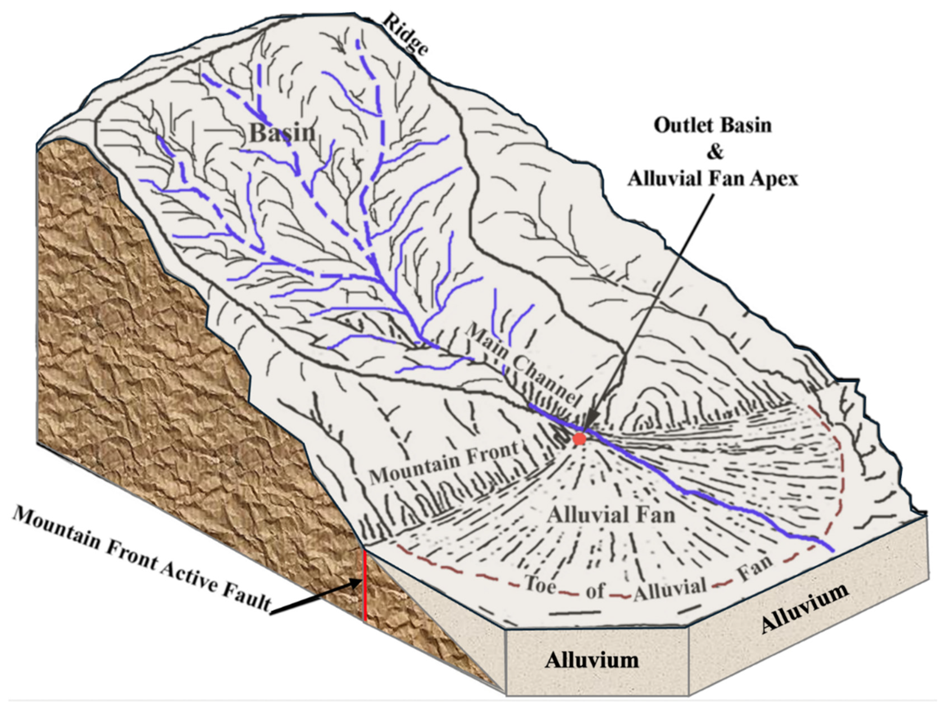
Figure 2.
Alluvial fan mapping projects in Colorado.
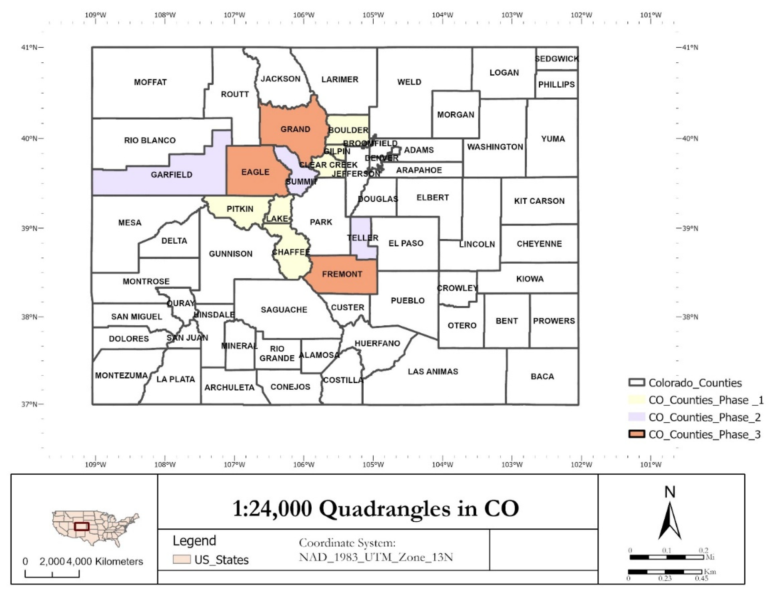
Figure 3.
Map showing 1,942 24k-quadrangle geologic maps, county boundaries in Colorado, and approximately 703 24k geologic quadrangles that were mapped by the CGS (321) and USGS (382).
Figure 3.
Map showing 1,942 24k-quadrangle geologic maps, county boundaries in Colorado, and approximately 703 24k geologic quadrangles that were mapped by the CGS (321) and USGS (382).
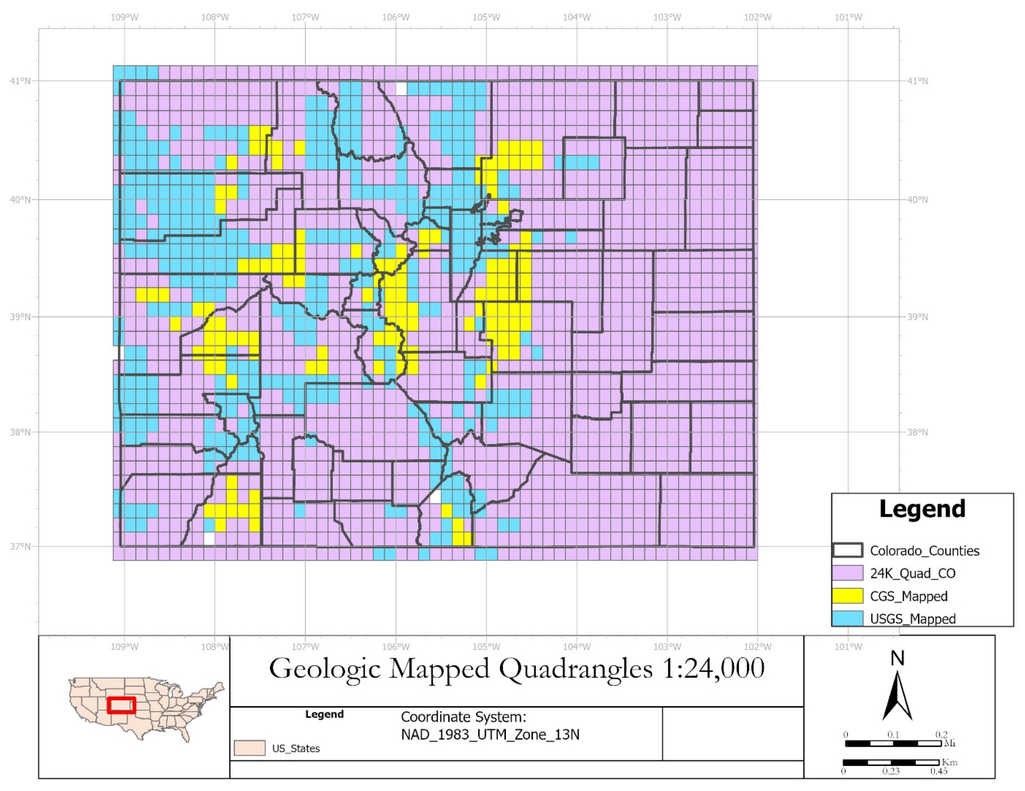
Figure 4.
(a) Portion of the geologic map of the Breckenridge Quadrangle [13], Summit and Park Counties, Colorado, (b) LiDAR-based mapping identified previously unmapped or misclassified alluvial fan, and (c) LiDAR-based alluvial fan mapping can be used to update the geologic map.
Figure 4.
(a) Portion of the geologic map of the Breckenridge Quadrangle [13], Summit and Park Counties, Colorado, (b) LiDAR-based mapping identified previously unmapped or misclassified alluvial fan, and (c) LiDAR-based alluvial fan mapping can be used to update the geologic map.
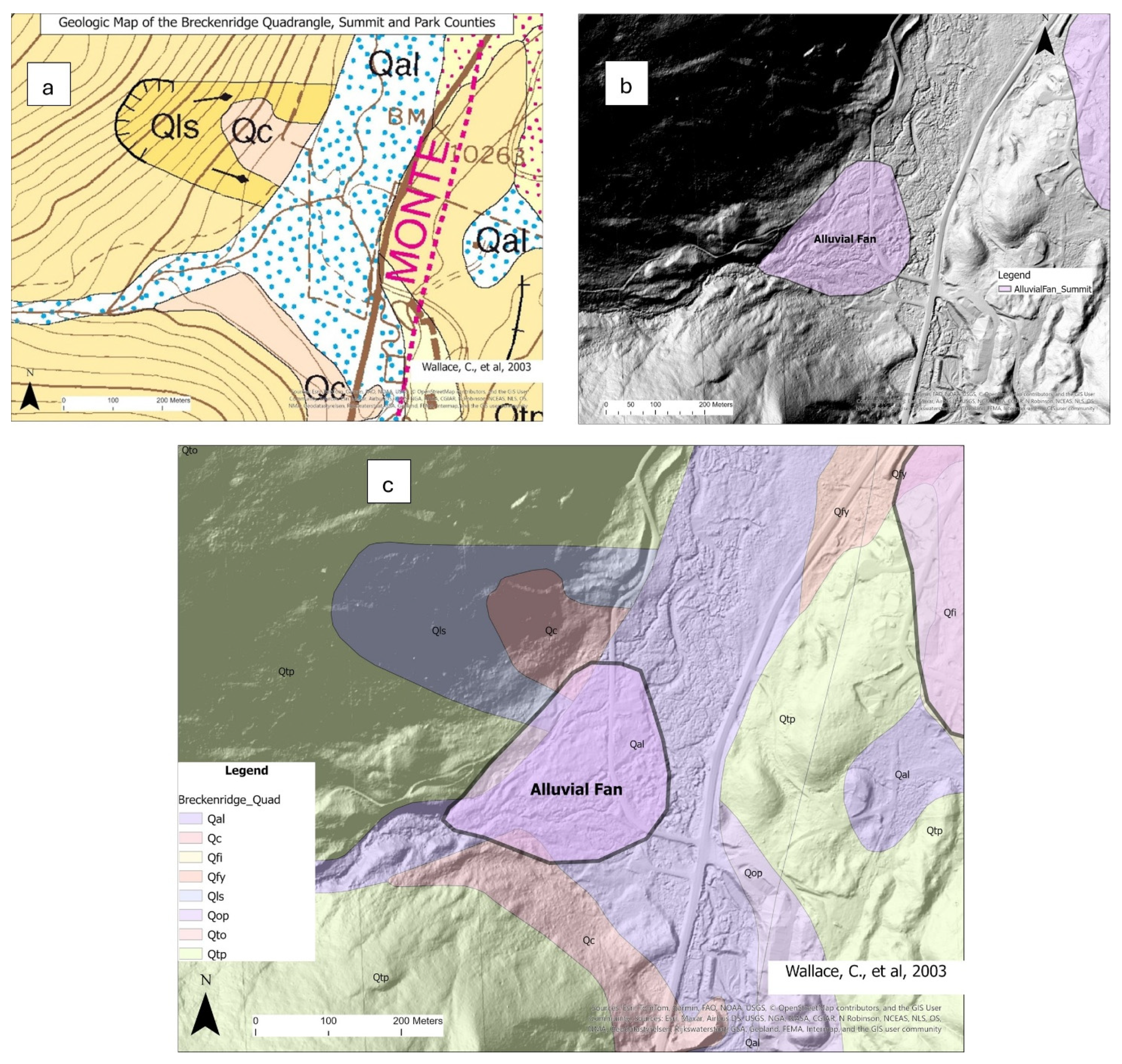
Figure 5.
A comparison of a partially mapped fan from the existing geologic map with the LiDAR-based mapping extends the mapped area to depict the entire alluvial deposits, which are indicated in the legend as pink polygons labeled as Chaffee_AlluvialFans (LiDAR-Based Alluvial Fan Mapping Project in Chaffee County, Colorado). Qf = Fan Deposit [14].
Figure 5.
A comparison of a partially mapped fan from the existing geologic map with the LiDAR-based mapping extends the mapped area to depict the entire alluvial deposits, which are indicated in the legend as pink polygons labeled as Chaffee_AlluvialFans (LiDAR-Based Alluvial Fan Mapping Project in Chaffee County, Colorado). Qf = Fan Deposit [14].
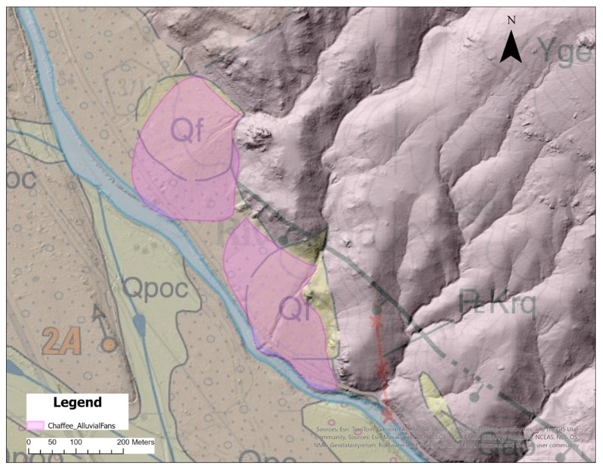
Figure 6.
3D illustrations of alluvial fan terminology (a) and a mapped fan.
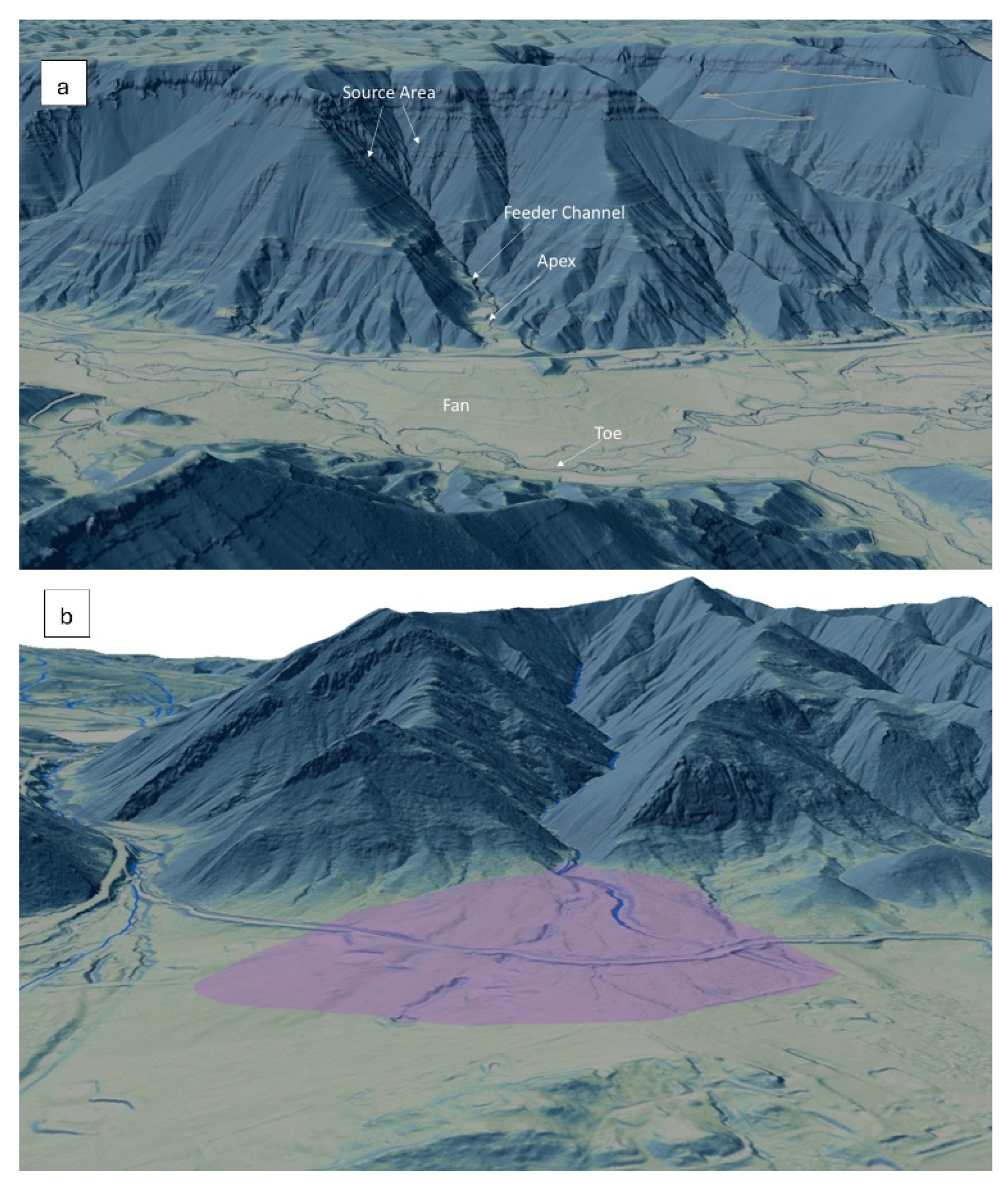
Figure 7.
Steps used for identifying fan-shaped landforms from available LiDAR data.
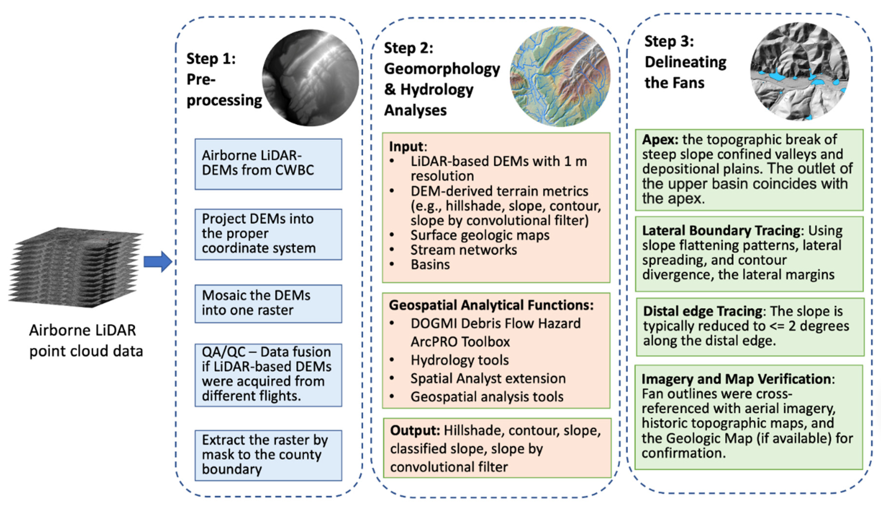
Figure 8.
(a) Slope showing the distal extent of the alluvial fan; (b) the convolution filter showing elevation variability across the DEM - slope threshold is approximately 15 degrees (LiDAR-Based Alluvial Fan Mapping Project in Pitkin County, Colorado).
Figure 8.
(a) Slope showing the distal extent of the alluvial fan; (b) the convolution filter showing elevation variability across the DEM - slope threshold is approximately 15 degrees (LiDAR-Based Alluvial Fan Mapping Project in Pitkin County, Colorado).
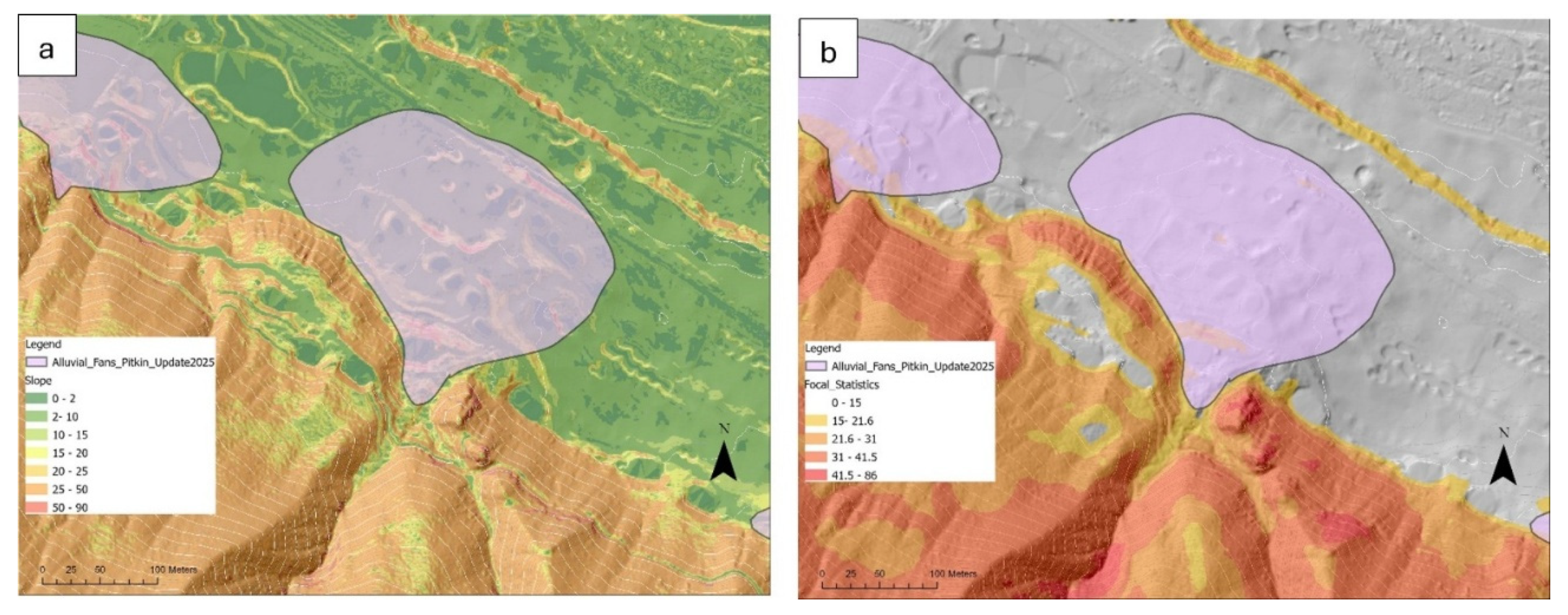
Figure 9.
The fan delineation workflow, which includes terrain analysis, surface geologic mapping, and hydrology analysis, in addition to delineating the fans.
Figure 9.
The fan delineation workflow, which includes terrain analysis, surface geologic mapping, and hydrology analysis, in addition to delineating the fans.
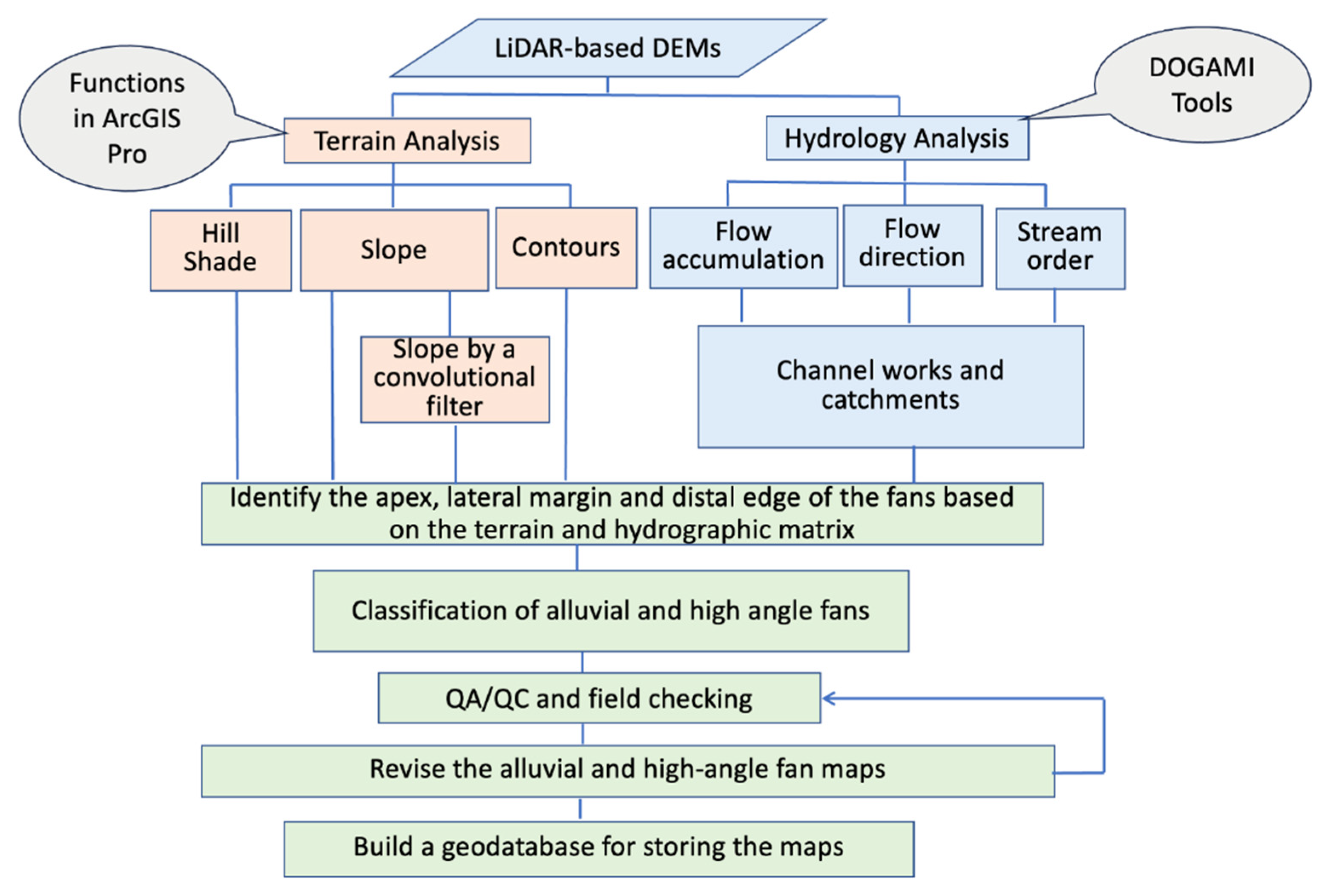
Figure 10.
Mapped alluvial fans in a portion of Clear Creek County.
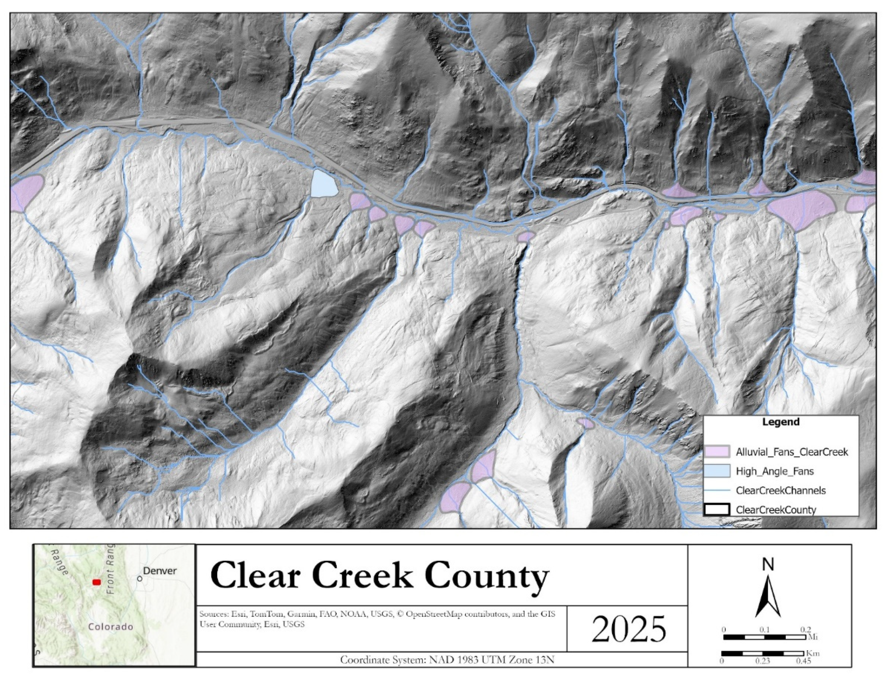
Figure 11.
Existing structures associated with the alluvial fans in Clear Creek County.
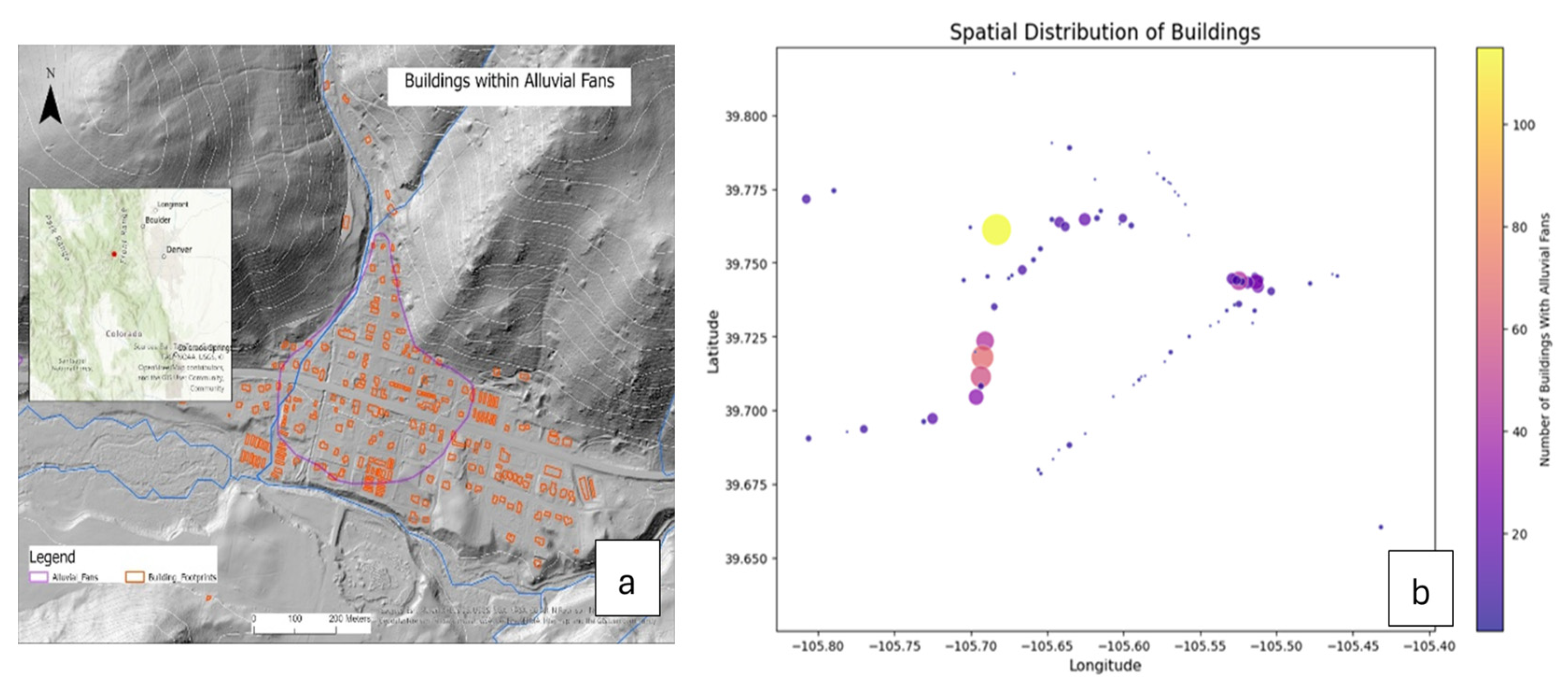
Figure 12.
Mapped alluvial fans in a portion of Pitkin County.
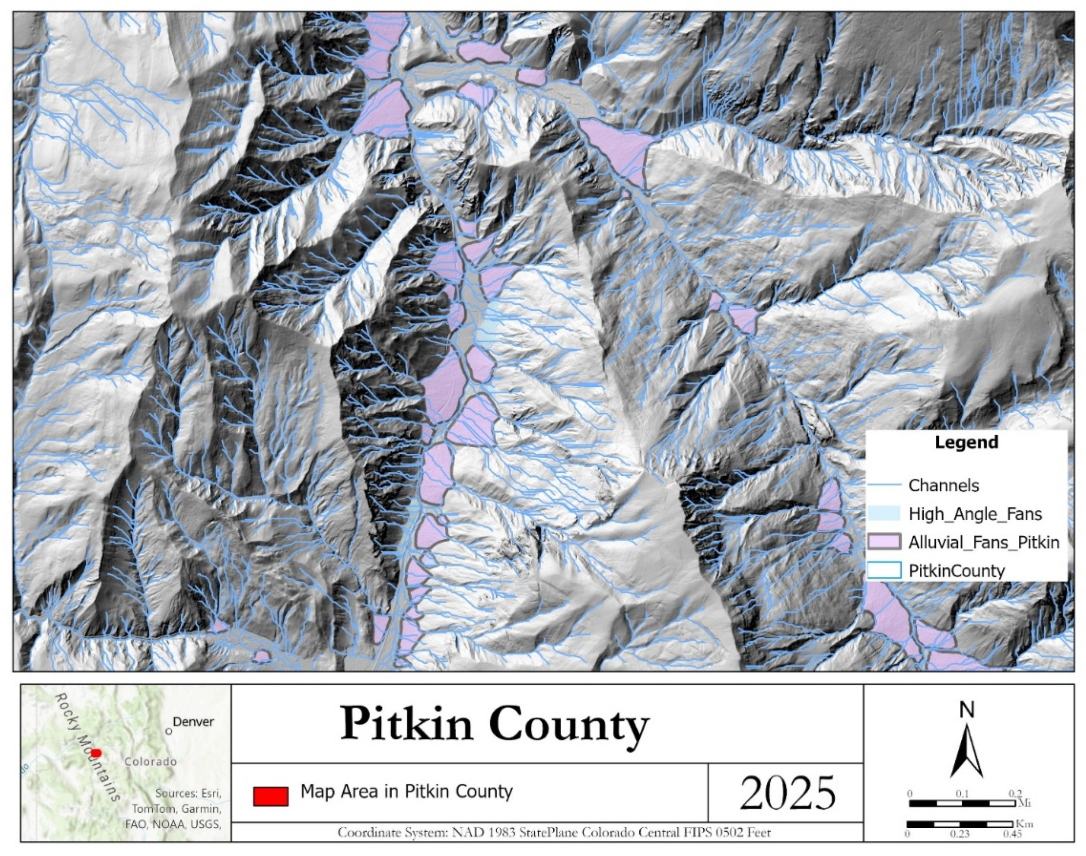
Figure 13.
A bajada or coalesced fans in Pitkin County (LiDAR-Based Alluvial Fan Mapping Project - Pitkin County).
Figure 13.
A bajada or coalesced fans in Pitkin County (LiDAR-Based Alluvial Fan Mapping Project - Pitkin County).
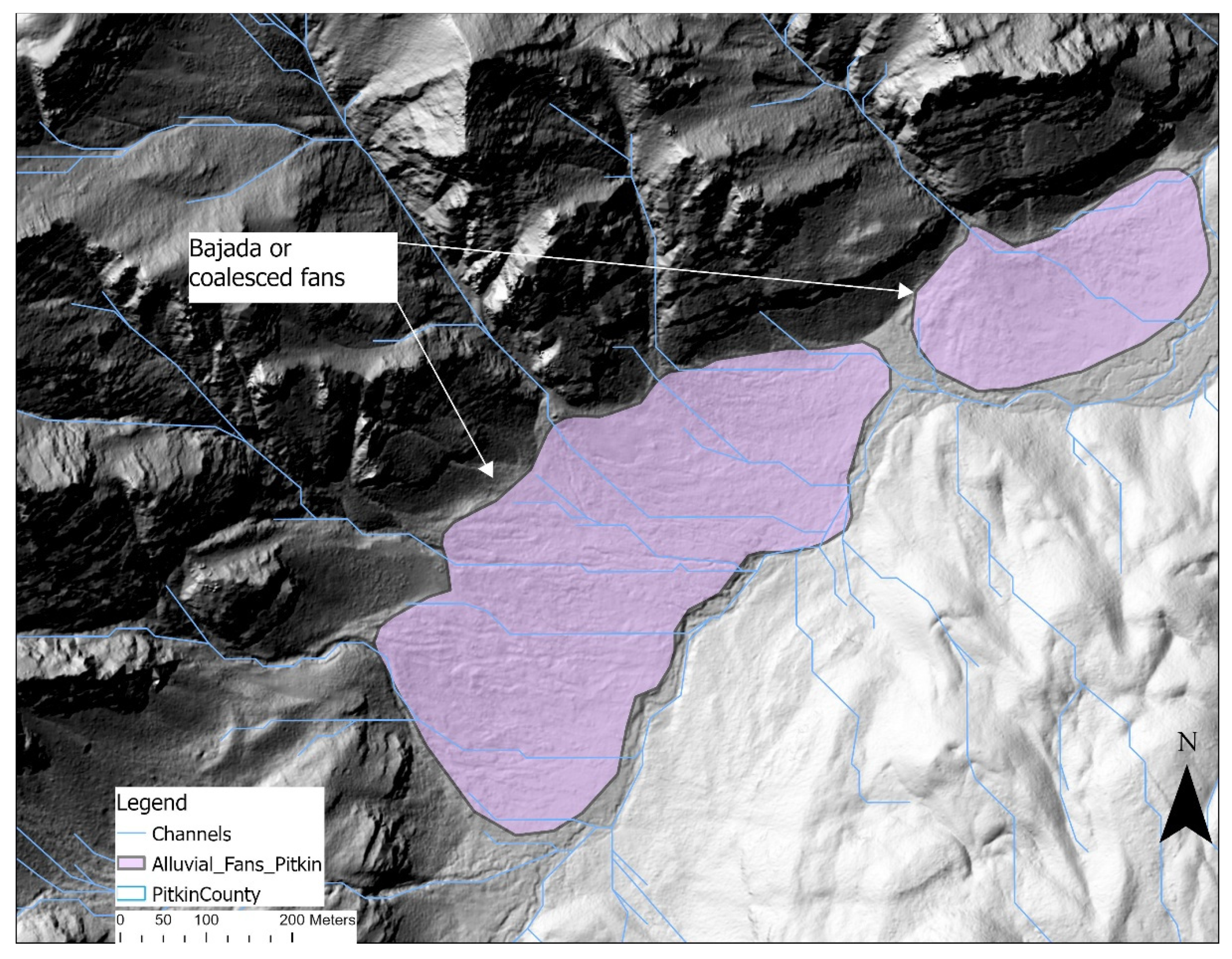
Figure 14.
Talus slope in Pitkin County with highway cutting through the fan (LiDAR-Based Alluvial Fan Mapping Project - Pitkin County).
Figure 14.
Talus slope in Pitkin County with highway cutting through the fan (LiDAR-Based Alluvial Fan Mapping Project - Pitkin County).
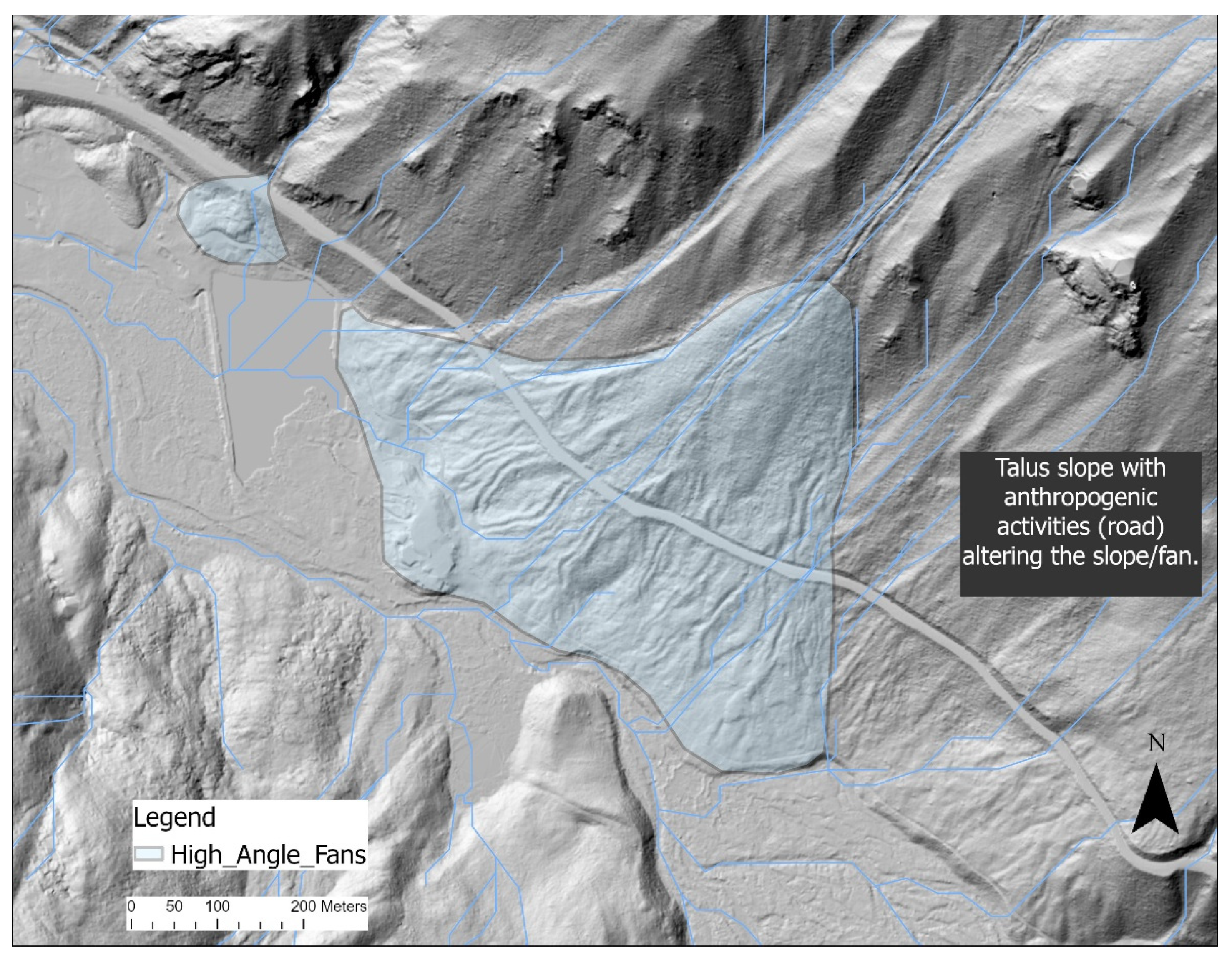

Table 1.
Summary of Data Acquisition .
| Name | Source | Description | Geodatabase feature |
|---|---|---|---|
| Geology | USGS and CGS | Surface Geology digitized from USGS and CGS maps | Polygon features |
| Elevation | CWCB – LiDAR Collection | Digital Elevation Models with 1 m resolution | GeoRasters |
| Stream Networks | DOGAMI Debris Flow Hazard ArcPRO Toolbox* modified by CGS, or created in this project by running the Hydrology tools in ArcGIS Pro | Channel data | Polyline Feature Class |
| Basin | DOGAMI Debris Flow Hazard ArcPRO Toolbox modified by CGS | Area of land in which all flowing surface water converges to a single point, such as a river. | Polygon Feature Class |
| Alluvial Fans | CGS (this project) | Digitized Alluvial Fans | Polygon Feature Class |
| Building Footprints | County’s GIS Database | Locations of existing structures | Polygon Feature Class |
USGS – United States Geological Survey, CGS – Colorado Geological Survey, DOGAMI - Oregon Department of Geology and Mineral Industries, Esri – Environmental Systems Research Institute, NLCD – National Land Cover Dataset.
Table 2.
Summary of Alluvial and High Angle Fans.
| County | Alluvial Fan Landform | High Angle Fan Landform | URL to Published Map |
|---|---|---|---|
| Pitkin | 662 | 309 | https://coloradogeologicalsurvey.org/publications/alluvial-fan-map-pitkin-colorado/ |
| Boulder | 603 | 21 | available soon |
| Lake | 64 | 93 | available soon |
| Chaffee | 181 | 894 | available soon |
| Gilpin | 219 | 2 | available soon |
| Clear Creek | 187 | 19 | https://coloradogeologicalsurvey.org/publications/alluvial-fan-map-clear-creek-colorado/ |
Disclaimer/Publisher’s Note: The statements, opinions and data contained in all publications are solely those of the individual author(s) and contributor(s) and not of MDPI and/or the editor(s). MDPI and/or the editor(s) disclaim responsibility for any injury to people or property resulting from any ideas, methods, instructions or products referred to in the content. |
© 2025 by the authors. Licensee MDPI, Basel, Switzerland. This article is an open access article distributed under the terms and conditions of the Creative Commons Attribution (CC BY) license (http://creativecommons.org/licenses/by/4.0/).
Copyright: This open access article is published under a Creative Commons CC BY 4.0 license, which permit the free download, distribution, and reuse, provided that the author and preprint are cited in any reuse.


