

Submitted:
30 June 2025
Posted:
07 July 2025
You are already at the latest version
Abstract
This study presents an interdisciplinary and multidisciplinary approach to the in-vestigation of the village of El Arellano. Founded in the late 18th century as part of Carlos III's colonization project for Sierra Morena and Andalusia, El Arellano was facing loss due to its current abandonment. By combining techniques such as historical and UAV aerial photogrammetry, archaeological prospection, analysis of historical sources, and remote sensing within a GIS environment, we have significantly advanced the material and historical understanding of the village. This has allowed us to identify its internal structure and historical evolution. This research not only provides a solid foundation for planning future investigations but also serves to rescue this settlement from oblivion and introduce it to the general public.
Keywords:
modern history
; geophisics
; UAV
; archaeological prospection
; remote sensing
; cutlural heritage
; public engagement
1. Introduction
In 1767, a colonization project for Sierra Morena and Andalusia commenced under a common fuero, leading to the establishment of the Superintendence of New Settlements. This province was divided into two districts: the New Settlements of Sierra Morena, with its capital in La Carolina, and the New Settlements of Andalusia, with its capital in La Carlota. Key figures in Bourbon reformist policies, such as the Count of Campomanes, Miguel de Múzquiz, the Count of Aranda, and Pablo de Olavide, were instrumental in this endeavor. The primary objectives of the project were to populate large tracts of land in the Iberian Peninsula to produce raw materials, increase the population, and establish or improve new communication routes, thereby enhancing the transit of goods and overall security. To achieve this, colonists were attracted from Central Europe as well as other parts of the Peninsula. Ultimately, and for a select number of enlightened thinkers, the project aimed to create and consolidate a substantial base of farming families that would serve as an engine and example for the rest of the Hispanic Monarchy [1] (pp. 25-94).
Initially, a dispersed settlement model was favored, with colonists' family homes situated within their land allocations. Subsequently, policies driven by economic savings and social cohesion led to the relocation of the population to main population centers and newly established villages [2] (pp. 69-70); [3] (pp. 151-160). However, some of these villages were quickly abandoned for various reasons, a process that impacted the Sierra Morena colonies more significantly than the New Settlements of Andalusia. This process of founding new population centers led to a shift in land occupation and exploitation, contributing to the current landscape configuration in Sierra Morena. The territory is punctuated by small localities that have experienced significant demographic crises almost from their inception, and their preservation has received limited attention. This oversight represents a loss of various heritage elements that define the contemporary Sierra Morena region.
An example of this abandonment, and the focus of this study, is the village of El Arellano, currently located within the municipality of Guarromán (Andalusia, Spain) (Figure 1). During the period of the Intendancy of New Settlements (1767-1835), this settlement faced a series of factors that contributed to its crisis and disappearance. Presently, only scarce vestiges remain despite the relatively short time since its abandonment. Historiography has largely attributed its disappearance to the Spanish War of Independence, although other factors, such as population loss in the parishes, the strengthening of main centres by authorities, or its geographical location within a prolonged depopulation process, also played a role [3] (p. 169). Although initially assigned to the parish of Carboneros due to its location on the boundary line between Carboneros and Guarromán (Figure 1), the village of El Arellano, also known as Los Llanos, ultimately fell within the parish of Guarromán. This latter aspect is evident in the Geographic Map of the New Settlements of Sierra Morena (1794-1797)[1]. Consequently, its constructions were distributed between the two parishes. The core of the settlement began to be built in 1774 with twenty houses [4] (p. 166); [5] (pp. 807-808).
The intendant Polo de Alcocer himself reported in 1833 that this village was particularly hard hit during the Spanish War of Independence. He described it within the parish of Carboneros, with a group of houses located on the Camino Real de Madrid, bisected by the dividing line between the municipalities of Carboneros and Guarromán [6]. A decade later, Pascual Madoz reported its state had been reduced to a single olive oil mill [7] (p. 40). While the Spanish War of Independence likely contributed to the village's abandonment and destruction, an analysis of census data reveals a progressive population decline in both Guarromán (from 665 inhabitants in 1781 to 471 in 1813, when it began to recover) and Carboneros (from 450 inhabitants in 1789 until its recovery began in 1813 with 337 inhabitants). Therefore, population losses were evident in the decades preceding the Spanish War of Independence, suggesting that the conflict alone cannot be blamed for this regression. The nearby towns of Carboneros and Guarromán, along with the village of Los Ríos belonging to the latter parish, likely acted as a magnet for its population. As larger centers with more services, they rendered this small settlement unviable, with the Spanish War of Independence inflicting irreparable damage [3] (p. 165). In the second half of the 19th century, only three houses were mentioned alongside the olive oil mill, with eight being recorded at the beginning of the 20th century, though not all were in good condition or inhabited. The village, coupled with the regional mining crisis, disappeared during the mid-20th century2.
Currently, only some foundation remnants and fragments of ceramic jars are visible on the surface. The neglect and oblivion into which this village has fallen represent a loss of a historical fragment that shaped the morphology of Sierra Morena in the current province of Jaén.
To address these issues, the project we have developed, whose methodology and results are presented in this article, has approached the village of El Arellano from a dual perspective. On one hand, it aims to rescue the village from oblivion and abandonment through a combined study of existing historical data, archaeological prospection, and the latest advancements in non-invasive analysis techniques based on terrestrial and aerial remote sensing. On the other hand, it seeks to disseminate this information to the general public by leveraging existing cultural itineraries.
Therefore, the development of this project has helped us transcend archival and historical cartographic information through the use of non-invasive archaeological methodologies (terrestrial and aerial remote sensing). This has allowed us to deepen our understanding of the spatial and functional distribution within one of the abandoned villages of the New Settlements of Sierra Morena, enabling us to extract information with two objectives:
To obtain a documentary base that can serve as a reference for comparative study with other New Settlements and their villages.
To provide the necessary information for its enhancement.
Thanks to the achievement of these objectives, we have made the research developed in our projects accessible to the public, aiming for it to be a source of enrichment for the region.
2. METHODOLOGY
For the research presented in this article, we adopted an inter and multidisciplinary approach based on both our own experience [8] and numerous case studies [9,10,11,12,13]. The GIS software used to combine the obtained data was QGIS 3.28.1. Furthermore, we utilized publicly available datasets from the National Geographic Institute's download center [14], such as historical orthophotography and LiDAR data. Similarly, the historical cartography used as a basis for the proposed village layout is freely accessible via WMS service directly within the GIS software, complemented by a visit to the municipal historical archive of Guarromán. In addition to these data, we conducted a photogrammetric drone flight over the village of El Arellano, which allowed us to obtain high-detail orthophotography (2 cm/pix) and a DEM, as well as a surface archaeological prospection and a geophysical prospection of the village area.
2.1. GIS Software and National Geographic Institute
QGIS v.3.28.1 [15] was chosen as the Geographic Information System (GIS) software due to its robust geospatial processing capabilities, open-source nature, and proven efficiency in integrating and analyzing heterogeneous data. These attributes make it a widely used and recommended tool for complex geographical studies [16,17].
Its use allowed for the combination of both cartography downloaded from the IGN and data provided via WMS [18]. While WMS data cannot be downloaded, QGIS's interoperability enabled direct work with this information and the generation of graphic materials. This cartography covered a historical range, from the American Series A flight conducted between 1945-1946 (discussed later) up to the present day. This approach is similar to that employed by Esquilache and García-Contreras in the Vega de Granada, where historical orthophotography was combined with historical cartography [19].
2.2. Aerial Orthophotography
For the aerial orthophotography, we utilized a DJI Phantom IV RTK drone. The drone was flown at an altitude of 85 m above ground level, with a 70% frontal overlap and an 80% lateral overlap. This resulted in an orthophotograph composed of 74 individual images, covering a total area of 0.0336 km² with a spatial resolution of 2.14 cm/pix.
Additionally, eight GCP were established using a Spectra Geospatial 30 differential GPS, ensuring centimetric precision. The geographic reference system for this data acquisition was ETRS89, UTM 30N. In contrast, the coordinate system for the drone's captured photographs was WGS84.
Due to this disparity in reference systems between the captured photographs and the control points, a coordinate system conversion was necessary. The target reference system was ETRS89 UTM 30N, as it is the official Spanish system [20]. This conversion process was automated by the software, Agisoft PhotoScan [21], which performed the transformation from one system to the other automatically.
2.3. LiDAR Data vs. DEM
For the research presented in this article, we opted to use the DEM generated from the photogrammetric flight described previously. This selection was primarily driven by two key factors:
The surveyed area was devoid of vegetation (having been cleared prior to the work). Therefore, the vegetation penetration capability inherent in LiDAR data was not an advantage in this specific case, unlike in other areas with dense vegetation [22,23].
The publicly available LiDAR data for this article came from digital files containing altimetric information from LiDAR point clouds, distributed in 1x1 km files. These point clouds were captured via LiDAR sensor flights with a density of 5 points/m² or greater. Consequently, the spatial resolution of a DEM generated from this LiDAR data would be reduced for our objectives, approximately 0.5 m/pix, compared to the 4.29 cm/pixel obtained from the DEM generated by our photogrammetric flight.
The precision of DEMs has been the subject of numerous studies [24,25,26], which have concluded that with proper topographic support, such as the GCPs implemented in this study, their precision is high, especially in scenarios like ours where vegetation was absent.
Once the DEM was selected, we proceeded with its analysis using the QGIS plugin, Relief Visualization Toolbox. This tool allowed us to apply various visualization filters to the DEM, including Analytical Hillshading and Hillshading from multiple directions, Slope, Sky-view Factor, Openness, and Local Dominance [27,28,29]. We also conducted a direct visualization analysis by adjusting the DEM's display values, which proved effective for identifying superficial archaeological remains (figure 2) whose presence was further corroborated by other sources used in this article.
2.4. Historical Orthophotography
American Flight Series A
The American Flight Series A was conducted during the final stage of World War II, specifically between late January 1945 and early October 1946. The Army Map Service of the United States carried out this aerial survey over Spanish territory, known as "Series A," which yielded a photographic mosaic used to create a 1:50,000 scale map of Spain.
The Cartographic and Photographic Center of the Air Force (CECAF), custodian of the negatives, digitally delivered the photograms to the IGN in 2014. The IGN then performed an approximate georeferencing of these photograms based on the provided data, resulting in orthophotos with resolutions of 50 cm and 1 m. These can be accessed through the IGN's Digital Photo Library (Figure 3) [33].
National Plan for Aerial Orthophotography
In addition to the aforementioned American Flight Series A, Spain possesses a substantial collection of photograms from aerial photographic flights conducted across the national territory, dating back to the late 1920’s. These historical flights were sponsored by various public administrative bodies, yielding a wealth of photograms and orthophotos, collectively known as Historical Photograms and Orthophotos.
Since 2008, the Historical PNOA project was launched. Its objective is to safeguard and make this valuable information available to all citizens. Since its inception, various agencies within the AGE and regional autonomous administrations have facilitated the scanning and orthorectification of these historical photograms.
The photograms from the historical flights shown below (Table 1).
As can be appreciated, the data generated by the AGE and Autonomous Administrations are downloadable, whereas the photograms from the flights conducted by the U.S. Army Map Service are available to users only for visualization. However, ungeoreferenced compositions can be downloaded in PDF format via the Digital Photo Library web viewer. To download a photogram, it is necessary to submit a request for these photograms to CECAF and CEGET.
2.4. Geophysical Prospection
Ground-penetrating radar (GPR) offers significant potential for archaeological investigation, particularly for documenting subsurface archaeological remains. It allows for the corroboration of information from historical sources and the precise localization of various buried structures [34,35]. Furthermore, GPR data can be integrated with other data sources, such as those described in this article [36,37]. It can also play a crucial role in the conservation of an archaeological site by becoming a fundamental tool for planning the time and costs of archaeological interventions [38].
For the geophysical prospection discussed in this article, the instrument used was a Stream X multi-channel GPR. This system consists of 15 antennas with a central frequency of 200 MHz, spaced 12 cm apart, providing a scanning bandwidth of 1.6 m. The GPR was towed by a 4x4 vehicle belonging to the Geodetection Unit of the University of Cádiz (Figure 4).
The prospection work was conducted with an exploration depth of 80 ns, utilizing 512 samples per scan (@512 Sample/Scan). An average propagation velocity of 10 cm/ns was assumed, and a GPS + PPS positioning system was employed.
For data acquisition, ONE VISION software, version 2.0.2, designed for radar detection and subsurface mapping, was used. Complementary to this, GRED HD software, version 01.07, developed for the visualization and processing of raw acquired radar data, was employed for post-processing. Both software packages were developed by the Italian company IDS (Ingegneria Dei Sistemi). The GRED HD software allows for various types of 2D and 3D post-processing of radar data, leveraging the full potential of different processing filters and 3D processing algorithms. Key outputs generated by GRED HD include longitudinal and transverse radargrams, as well as tomographies and 3D views of the explored area.
2.5. Written Sources
This phase of the work was fundamental for interpreting and integrating the data obtained from each of the aforementioned sources. It allowed us to identify some of the contents of historical texts with preserved material evidence, which will require corroboration in future archaeological research campaigns.
Regarding the historical sources consulted, both direct and indirect, documentation from the Municipal Historical Archive of Guarromán proved essential. Specifically, wealth catalogs (Amarillamientos) based on taxpayer declarations following the 1845 tax reform were crucial for identifying owners and possessions. These, along with late 19th and early 20th-century housing and population censuses, allowed us to formulate a hypothesis regarding the evolution of the number of dwellings that might have comprised the village [1]. We also relied on historical cartography, such as the Geographical Map of the New Settlements of Sierra Morena, preserved in the General Military Archive of Madrid (Figure 5). Other sources include Edme Mentelle's Plan général des Nouvelles Colonies de Sierra Morena (1783), whose data refer to 1770, a time when the village of El Arellano, founded in 1774, had not yet appeared. Finally, printed sources like the Memoria Histórica de las Nuevas Poblaciones de Sierra Morena y Andalucía (1833) by Intendant Pedro Matías Polo de Alcocer[3] were also consulted [2].
2.6. Archaeological Prospection
To corroborate the data obtained in the previous phases, document the current information and state of conservation of El Arellano village, and precisely locate both structural remains and artifacts such as ceramics, metal, and glass among others, which would allow us to superficially identify potential differences in the use of various spaces, an archaeological prospection of the village's surface was conducted.
The prospection was carried out by the team members equipped with GPS units to facilitate coverage of the area and the georeferencing of surface-documented materials. In this instance, the prospection was constrained by the surface condition of the terrain. Although the plot had been cleared prior to the survey, the remnants of this work remained irregularly distributed across the surface. Consequently, we were only able to precisely document surface structures and material remains in areas where this vegetation had been completely removed.
3. Results
3.1. Historical photographs
Of the historical orthophotographs analyzed, the American flights have provided the most information, especially Series A, which allowed us to extract valuable data regarding the dimensions and compartmentalization of the dwellings, as remains of the village were still standing when these images were captured. Regarding the other datasets analyzed, the absence of clear surface evidence of the village confirms the abandonment and deterioration experienced by the settlement since its desertion (Figure 6).
Thanks to Series A (Figure 6a), we were able to propose a plan for the village, which appears to be quadrangular with hypothetical dimensions of approximately 95 x 95 m. with an approximate surface area of 8,961.51 m². These dimensions do not align with the current state of preservation, as only its length (95 m) has been fully documented today, its original width having been lost during the construction of the A4 highway. Nevertheless, we could discern the rectilinear layout of the main east-west oriented street, with a documented approximate width of 3 m. This street was also aligned with the Camino Real de Madrid, which similarly has a width of three meters (1). In the centre of the village, we documented the presence of a square delimited by four dwellings forming an octagon, with an approximate surface area of 600 m² (2). This square, in turn, is divided by a street running northwest-southeast, perpendicular to the main street, also with an approximate width of 3 m (3). Furthermore, in the northeast corner, we could infer an internal compartmentalization of approximately 30 x 30 m (900 m²), which appears to be repeated in all four corners of the village. Within this, an internal compartmentalization of 30 x 10 m (300 m²) is also hinted at, which could correspond to the interior courtyards of the identified dwellings, whose existence we propose later (4).
Regarding the data obtained from Series B (Figure 6 b), it corroborates some of the information from Series A. Although very diffused, in the southwest corner, we can observe a quadrangular compartmentalization of similar dimensions to those documented in Series A, i.e., approximately 30 x 30 m (1). This further confirms the aforementioned structure.
The remaining historical images studied provided no further information due to, as stated, the abandonment experienced between 1940 and 1957, with the last surface vestiges documented in the aforementioned American flights (Figure 6c – f). Nevertheless, this lack of information is indicative of the process of deterioration and loss of the village's material remains, which, combined with information from other sources, will allow us to develop a detailed conservation and research plan.
Aerial orthophotography
The results obtained from aerial orthophotography have been of great assistance in the study and identification of the material remains preserved on the surface (Figure 7)
Thanks to the high resolution of the generated orthophotography (2.14 cm/pix), we have a robust base for future interventions and for the work developed during this research project. It served as the base map for planning the archaeological prospection, which we'll discuss later, and for integrating the results obtained.
Additionally, we were able to identify the remains of a dwelling that are difficult to discern on the surface (Figure 7, detail). This identification allowed us to mark it as an area of special interest for the archaeological prospection.
In the southwest corner, we also identified the presence of a threshing floor whose dimensions and structure are discernible. This feature was documented in detail during the archaeological prospection and can be consulted in further detail in section 3.6.1 and Figure 13.
DEM
The DEM generated from the photogrammetric flight clearly revealed the village's layout and the presence of the previously mentioned threshing floor, approximately 30 m in diameter (1). Furthermore, thanks to the resolution of the DEM and the combination of colors and visualization parameters described earlier, we were able to document the plan of the aforementioned dwelling in greater detail (Figure 8 detail). This allowed us to confirm the dwelling's existence, extract more precise measurements, and propose an internal compartmentalization (Figure 8). The interior measurements of the dwelling were 8.3 x 2.5 m, resulting in an approximate internal area of 20.75 m², while the exterior approximate measurements were 13.8 x 5.5 m, yielding an approximate area of 75.9 m².
RVT analysis
Regarding the visual analyses performed using the QGIS RVT plugin, we present only those that provided relevant information, as some analyses yielded no surface visibility or redundant data. Thus, the analyses displayed in figure 9 are:
- (a)
- SVF-A_R10_D16_A315_Allow
- (b)
- SLOPE
- (c)
- MSRM_F_M0.0-20.0_S2
As can be seen in Figure 9, the information is particularly evident in the southwest corner of the village. We again documented the threshing floor, marked only in Figure 9 (a) to avoid redundancy, whose dimensions align with those previously described, specifically 30 m in diameter. In Figure 9 (b), we can discern the beginning of an internal compartmentalization of the residential structure, which was confirmed in Figure 9 (c). This revealed a much more complex space than initially perceived, identifying a division into four interior spaces whose dimensions vary between 8 x 7.5 m and 9 x 7.5 m.
3.5. Geophysics
The results obtained from the geophysical prospection were complementary to the information gathered in previous phases. On one hand, it enabled us to identify and pinpoint the presence of some of the village dwellings, including their layouts and dimensions, particularly those of the central square. These are rectangular in plan with no internal compartmentalization. Their identification allowed us to compare them with the dimensions of the dwelling identified in the aerial orthophotography and the DEM.
On the other hand, in addition to the above, geophysical prospection allowed us to precisely ascertain the state of preservation of the dwellings and accurately plan subsequent archaeological research campaigns.
The area that yielded the most information was the central part of the village, where the dwellings forming the aforementioned central square could be identified (Figure 10).
Thanks to this work, we were able to precisely document the dimensions of dwellings numbered 1 and 2. These measured 13 x 5.5 m, resulting in a surface area of 71.5 m², which is very similar to the dwelling previously identified in the DEM.
On the opposite side, structures numbered 3 and 4 are more incomplete. This is due to the terrain's topography (very stony from collapsed dwellings), which made it impossible for the georradar to pass over their surfaces, preventing more detailed documentation. Nevertheless, the width we could document for structure 3 is 4.3 m, while structure 4 reached 5.5 m, though its length could not be documented.
Finally, we were able to quantify the preserved thickness of the walls and their depth, finding them to be 70 cm from the surface. The preserved thickness of the structures varies from 40 cm for structures 1, 2, and 4, up to 70 cm for structure 4.
3Archaeological prospection
The surface archaeological prospection allowed us to connect the material remains documented on the surface (Figure 11) with some of the information extracted from the historical texts and documents consulted.
During the work, in addition to locating construction ceramic material distributed across the entire surface of the village, we were able to identify some very interesting aspects regarding the functions performed within the dwellings and their constructive structure (Figure 11).
3.6.1. Threshing Floor
The structure marked as 1 in figure 11 is the aforementioned Threshing Floor (Figure 12), which we were able to document in detail thanks to the archaeological prospection, and for which we present a proposed design. As mentioned, it has an exterior diameter of 30 m, and internally, a concentric circle 6.36 m in diameter is identified. It is also sectioned by a total of 12 radial divisions in the inner circle and 56 in the outer. Its location at the western edge of the village, directly in front of the main road (Camino Real de Madrid), suggests that although it might not have been constructed at the very beginning of the village's occupation, its use was simultaneous during some of the documented occupation phases of the village. Its presence is not recorded in the consulted texts.
3.6.2. Walls
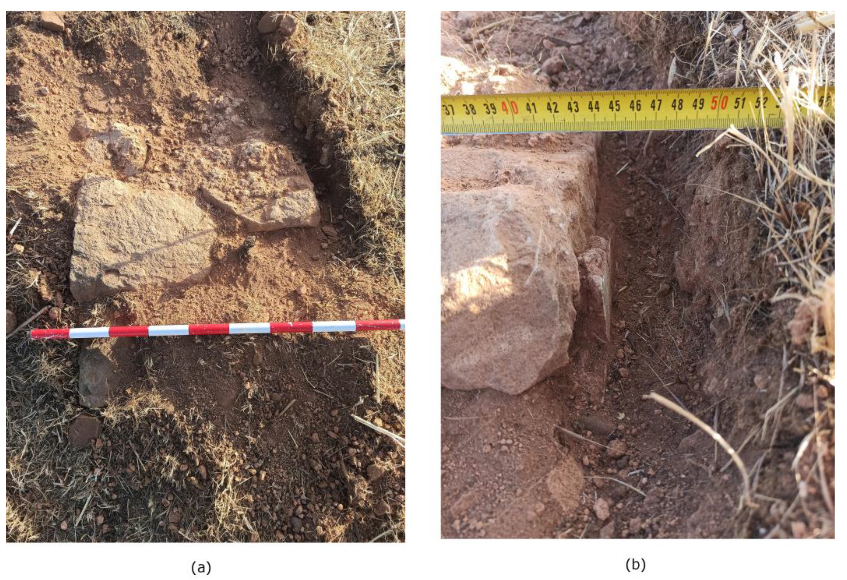
The wall we are presenting corresponds to item number 2 in Figure 11. As can be seen in Figure 13 (a), it was constructed from medium-sized stones bound with mortar and had an approximate width of 70 cm. Furthermore, we were able to document the presence of plaster remnants, approximately 1 cm thick, on the interior. This suggests that the interior of the dwellings would have been covered by a thick layer of what appears to be lime (although specific analyses would be required to confirm this), serving both to homogenize the surface and facilitate hygiene within the homes
Figure 13.
(a) Wall of house 1. (b) Detail of the interior plaster of the dwelling.
3.6.3. Storage Containers
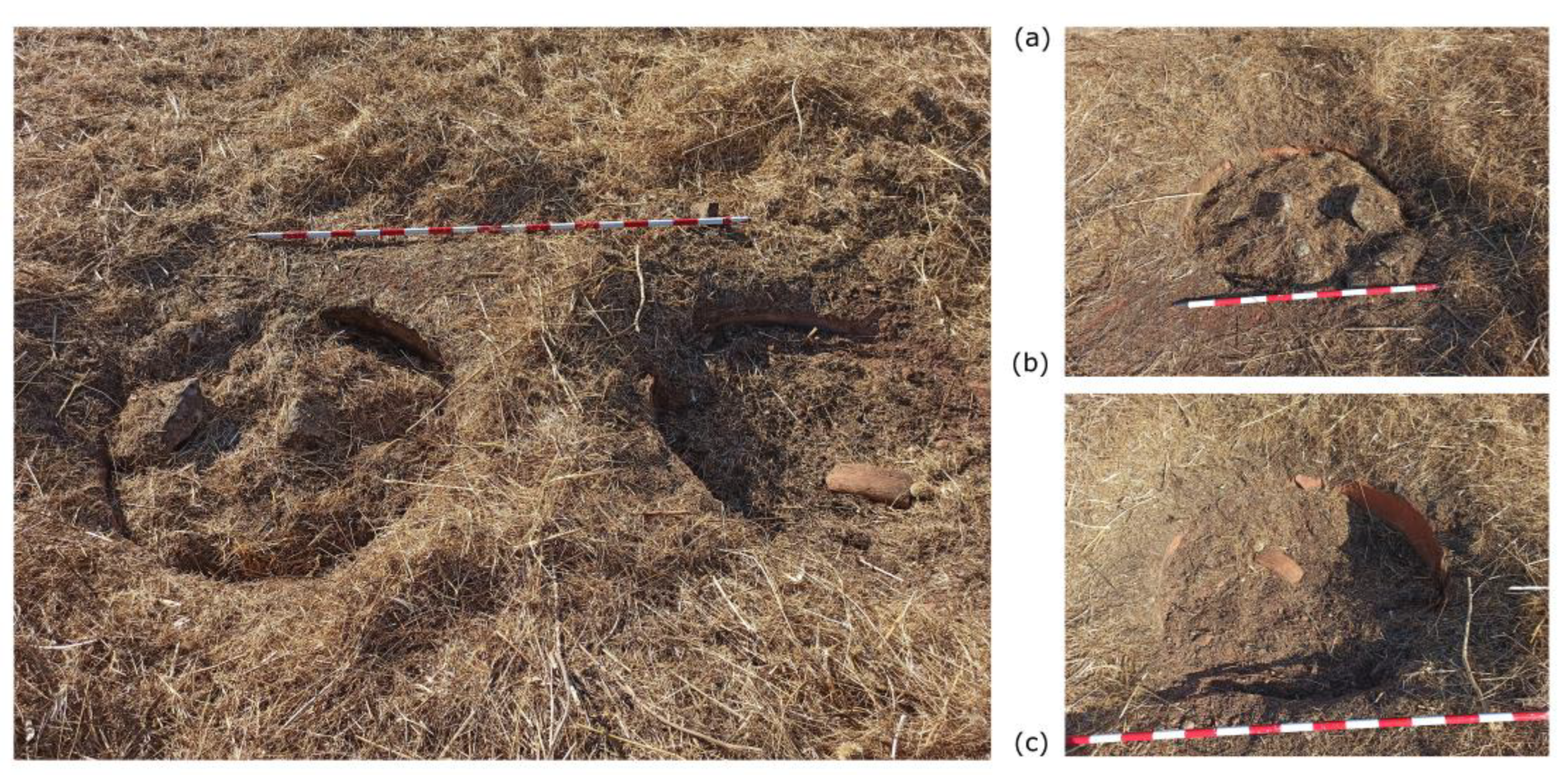
Finally, during the prospection, we documented the presence of several large storage containers grouped in pairs at the southern edge of the village (Figure 11.3, 14). The approximate 1 m diameter of these containers allowed us to precisely infer their function in this specific area, as no similar containers were identified in other parts of the village.
Figure 14.
(a) View of one of the documented groups of storage containers. (b) y (c) Detailed views of the
documented containers. Source: Authors' own work.
Figure 14.
(a) View of one of the documented groups of storage containers. (b) y (c) Detailed views of the
documented containers. Source: Authors' own work.
3.6. Historical documentation
We have documented a total of eight distinct phases in the history of the village:
1767: The initiation of the founding process for the New Settlements of Sierra Morena by King Charles III.
1774: The establishment of El Arellano village, comprising 20 houses.
1781 – 1818: A period of population crisis leading to the gradual abandonment of the village by its inhabitants.
1835: Houses aligned along the Camino Real de Madrid become divided by the boundary line between the municipalities of Carboneros and Guarromán.
1845 – 1850: The existence of an olive oil mill and two houses, owned by Margarita Reinhart in 1850, is documented. This confirms the trend of abandonment that began in 1781, with only agricultural workers remaining.
Late 19th Century: Only three inhabited houses remain, with a population of 51 according to the 1897 census, attributed to the mining boom in the region.
1898 – 1910: Dwellings are abandoned for a few years before being reoccupied in 1910, with eight houses recorded.
1940 – 1957: The village disappears. The Guarromán town council cedes two plots in El Arellano village to landless individuals for cultivation.
Discussion
The inter- and multidisciplinary approach adopted in this study has significantly advanced our understanding of El Arellano village. The combined use of various GIS-based sources has allowed us to piece together information like a puzzle, providing a comprehensive understanding of the village's structure and its historical evolution. This study now serves as a fundamental basis for future research.
The joint interpretation of the results reveals a quadrangular village plan with hypothetical dimensions of approximately 108 x 108 m (though currently, its preserved dimensions are 108 x 61 m). It was divided into four sectors by two perpendicular streets, oriented east-west and north-south, each with an approximate width of 3 meters. We documented one of the four identified sectors (the northwest sector) to be 30 x 30 m, and we hypothesize that these dimensions could be symmetrical in the other spaces formed by the intersection of the aforementioned thoroughfares. Within this sector, we identified a further division into four spaces, measuring 8–9 x 7.5 m, which we have not been able to discern in other village sectors.
We also extracted significant information about the construction techniques and dwelling dimensions. Specifically, the documented walls are approximately 70 cm thick, built of medium-sized stones bonded with mortar and covered with a 1 cm thick lime plaster. The dwellings would have had approximate dimensions of 13 x 5.5 m, which we documented in various areas, including the central square and the dwelling at the western end. Currently, they retain a preserved height of between 30 and 70 cm at a depth of 30 cm from ground level.
The surface identification of the storage containers (Figure 15) allowed us to attribute this function to the southern end of the village, contrasting with the aforementioned internal compartmentalization in the northwest corner. This leads us to hypothesize a possible division of functions within the village itself, though at the current state of our research, it's impossible to state definitively.
At the western end, the presence of a threshing floor, 30 m in diameter, was identified, though its period of use could not be precisely determined.
Traditional historical sources indicated that El Arellano village disappeared during the Spanish War of Independence, with only an olive oil mill remaining by the 1830s. Thanks to the combination of direct archival sources, we were able to demonstrate that the village's population crisis was not solely related to the Spanish War of Independence. Population decline was already evident in both the Guarromán and Carboneros parishes by the late 18th century, although, unfortunately, we could not establish a direct link between this and the material cultural remains in this project. We also confirmed the continued existence of some houses during the second half of the 19th century and early 20th century, not just the olive oil mill. The identification of some of these structures (we cannot confirm if they are precisely those referred to in the documentation) has come to light through the conducted work, corroborating the existence of those first houses built around the central square, which was traversed by the Camino Real de Madrid, with its chamfered ends.
Finally, it is worth noting that the data obtained from this project has been featured in a traveling exhibition between the municipalities of Carboneros and Guarromán (Jaén, Spain). Our aim was to raise awareness about a lost heritage, the existence of which was known, but about which very little or nothing was understood. In doing so, we sought to promote the conservation of the remaining vestiges and their associated history. Therefore, the exhibition serves as a tool to sensitize the general public to the significance of this forgotten heritage, helping them to comprehend both their past and present. Furthermore, we have successfully brought scientific methodology closer to the public, enabling them to appreciate and value the purpose of scientific work, thereby bridging the gap between science and society
Author Contributions
Conceptualization, Ortiz-Villarejo, Antonio J. and Pérez Fernández, F. José; F. José; Formal analysis, Ortiz-Villarejo, Antonio J, Pérez Fernández, F. José, Partal Ortega, Laura, Fernández Gersol, José C., Castillo Martínez, Juan M.; Writing—original draft preparation, Ortiz-Villarejo, Antonio J.; Pérez Fernández, F. José; Writing—review and editing, Ortiz-Villarejo, Antonio J; Visualization, Ortiz-Villarejo, Antonio J, Pérez Fernández, F. José, Partal Ortega, Laura, Fernández Gersol, José C., Castillo Martínez, Juan M.; Supervision, Ortiz-Villarejo, Antonio J; Project administration, Ortiz-Villarejo, Antonio J, Pérez Fernández, F. José; Funding acquisition, Ortiz-Villarejo, Antonio J, Pérez Fernández, F. José. All authors have read and agreed to the published version of the manuscript.”
Funding
This research was funded by Instituto de Estudios Giennenses, grant number 2023/4866
Data Availability Statement
Data availability under request.
Acknowledgments
The author would like to express our since acknowledgment to the Unidad de Geodetección of University of Cádiz for the job done with GPR.
Conflicts of Interest
The authors declare no conflicts of interest.
Abbreviations
The following abbreviations are used in this manuscript:
| DEM | Digital Elevation Model |
| WMS | World Maps Service |
| IGN | Instituto Geográfico Nacional |
| RTK | Real Time Kinematic |
| LiDAR | Light detection and ranging |
| GCP | Ground Control Point |
| GPS | Global Positioning System |
| QGIS | Quantum SIG |
| CECAF | Centro Cartográfico y Fotográfico del Ejército del Aire |
| CEGET | Centro Geográfico del Ejército |
| PNOA | Plan Nacional de Ortofotografía Aérea |
| AGE | Agencia Estatal |
| GPR | Ground Penetrating Radar |
| PPS | Post-Processing System |
| RVT | Relief Visualization Toolbox |
| GIS | Geographic Information Sistem. |
References
- Pérez-Schmid Fernández, F.J. Colonos y Propietarios de Las Nuevas Poblaciones de Sierra Morena Durante La Edad Moderna, Universidad de Jaén: Jaén, 2019.
- Oliveras Samitier, J. Nuevas Poblaciones En La España de La Ilustración; Caja de Arquitectos, 1998.
- Pérez-Schmid Fernández, F.J. Aldeas Coloniales Desaparecidas Durante La Etapa Foral En Las Nuevas Poblaciones de Sierra Morena y Andalucía. Anuario Histórico Ibérico, 2023. [Google Scholar]
- Sánchez-Batalla Martínez, C. La Carolina En El Entorno de Sus Colonias Gemelas y Antiguas Poblaciones de Sierra Morena. Prehistoria a 1835; Jaén, C. rural de, Ed. 1998. [Google Scholar]
- Reese, T.F. Las Nuevas Poblaciones de Sierra Morena y Andalucía. Reforma Agraria, Repoblación y Urbanismo En La España Rural Del Siglo XVIII; Iberoamericana-Vervuert, 2022;
- Polo de Alcocer, P. Memoria Histórica de Las Nuevas Poblaciones de Sierra Morena y Andalucía; Facsímil.; Seminario de estudios carolinenses;
- Madoz, P. Diccionario Geográfico-Histórico-Estadístico de Andalucía; Facsímil.; Ámbito ediciones: Madrid, Spain, 1998. [Google Scholar]
- Ortiz Villarejo, A.J.; Delgado Barrado, J.M.; Casagrande, G.; Valderrama Zafra, J.M. Remote Sensing and Archaeology in Modern Age: The Study Case of the Aldea de Buenos Aires in Sierra Morena. J Archaeol Sci Rep 2023, 51. [Google Scholar] [CrossRef]
- Mandolesi, L.; Montagnetti, R.; Pickel, D.G. Come nasce una base gis per l’archeologia opensource, sviluppata da archeologi per gli archeologi: lo scavo di poggio gramignano, lugnano in teverina (TR). Archeologia e Calcolatori 2022, 33, 93–112. [Google Scholar] [CrossRef]
- Triviño-Tarradas, P.; Molina, D.F.G.; Fernández, R.H.; Criado, I.C. Digital Representation of the Terrain Associated with an Archaeological Site: Case Study of the ‘Baker’s House’ in Torreparedones. Lecture Notes in Mechanical Engineering 2022, 3–10. [Google Scholar] [CrossRef]
- Zhang, J. Multi-Source Remote Sensing Data Fusion: Status and Trends Multi-Source Remote Sensing Data Fusion: Status and Trends. Int J Image Data Fusion 2010, 1, 5–24. [Google Scholar] [CrossRef]
- Uribe, P.; Angás, J.; Pérez-Cabello, F.; De La Riva, J.; Bea, M.; Serreta, A.; Magallón, M.A.; Sáenz, C.; Martín-Bueno, M. Aerial Mapping and Multi-Sensors Approaches from Remote Sensing Applied to the Roman Archaeological Heritage. In Proceedings of the International Archives of the Photogrammetry, Remote Sensing and Spatial Information Sciences - ISPRS Archives; International Society for Photogrammetry and Remote Sensing, 2015; Vol. 40; pp. 461–467. [Google Scholar]
- Siart, C.; Eitel, B.; Panagiotopoulos, D. Investigation of Past Archaeological Landscapes Using Remote Sensing and GIS: A Multi-Method Case Study from Mount Ida, Crete. J Archaeol Sci 2008, 35, 2918–2926. [Google Scholar] [CrossRef]
- Organismo Autónomo Centro Nacional de Información Geográfica Centro de Descargas Del IGN. Available online: https://centrodedescargas.cnig.es/CentroDescargas/index.jsp (accessed on 5 June 2020).
- QGIS QGIS Un Sistema de Información Geográfica Libre y de Código Abierto. Available online: https://qgis.org/es/site/ (accessed on 2 February 2019).
- Mastronuzzi, G.; Vizzino, G. GIS and DTM for the Analysis of the Archaelogical Data in Vaste (Southern Apulia). SCIRES-IT 2020, 10, 53–64. [Google Scholar] [CrossRef]
- Parra-Aguilar, L. The fortified defence of the west of the santaver cora through geographic information systems (gis): a multidisciplinary study. Virtual Archaeology Review 2024, 15, 161–176. [Google Scholar] [CrossRef]
- Instituto Geográfico Nacional (IGN) Plan Nacional de Ortofotografía Aérea. Available online: https://pnoa.ign.es/.
- Esquilache, F.; García-Contreras, G. The Vega de Granada Farmlands. Identifying the Cultivation Areas Irrigated by the Acequia Gorda de Granada during the Andalusi Period (8th-15th Centuries). Hist Agrar, 2024; 7–40. [Google Scholar] [CrossRef]
- BOE Real Decreto 1071/2007, de 27 de Julio, Por el que se regula el sistema geodésico de referencia oficial en España 2007, 35986–35989.
- Agisoft PhotoScan User Manual. Professional Edition, Version 1.0.0 2013.
- Chase, A.; Chase, D.; Weishampel, J.; Draje, J.; Shrestha, R.; Slatton, K.; Awe, J.; Carter, W. Airborne LiDAR, Archaeology, and the Ancient Maya Landscape at Caracol, Belize. J Archaeol Sci 2011, 38, 387–398. [Google Scholar]
- Evans, D.H.; Fletcher, R.J.; Pottier, C.; Chevance, J.-B.; Soutif, D.; Tan, B.S.; Im, S.; Ea, D.; Tin, T.; Kim, S.; et al. Uncovering Archaeological Landscapes at Angkor Using Lidar. Proceedings of the National Academy of Sciences 2013. [Google Scholar] [CrossRef]
- Gómez-Gutiérrez, Á.; Sánchez-Fernández, M.; de Sanjosé-Blasco, J.J.; Gudino-Elizondo, N.; Lavado-Contador, F. Is It Possible to Generate Accurate 3D Point Clouds with UAS-LIDAR and UAS-RGB? Photogrammetry without GCPs? A Case Study on a Beach and Rocky Cliff. Landsc Ecol 2024, 39. [Google Scholar] [CrossRef]
- Sohl, M.A.; Mahmood, S.A. Low-Cost UAV in Photogrammetric Engineering and Remote Sensing: Georeferencing, DEM Accuracy, and Geospatial Analysis. Journal of Geovisualization and Spatial Analysis 2024, 8. [Google Scholar] [CrossRef]
- Dai, W.; Zheng, G.; Antoniazza, G.; Zhao, F.; Chen, K.; Lu, W.; Lane, S.N. Improving UAV-SfM Photogrammetry for Modelling High-Relief Terrain: Image Collection Strategies and Ground Control Quantity. Earth Surf Process Landf 2023, 48, 2884–2899. [Google Scholar] [CrossRef]
- Štular, B.; Kokalj, Ž.; Oštir, K.; Nuninger, L. Visualization of Lidar-Derived Relief Models for Detection of Archaeological Features. J Archaeol Sci 2012. [Google Scholar] [CrossRef]
- Štular, B.; Lozić, E. Comparison of Filters for Archaeology-Specific Ground Extraction from Airborne LiDAR Point Clouds. Remote Sens (Basel) 2020, 12. [Google Scholar] [CrossRef]
- Štular, B.; Eichert, S.; Lozić, E. Airborne LiDAR Point Cloud Processing for Archaeology. Pipeline and QGIS Toolbox. Remote Sens (Basel) 2021, 13, 3225. [Google Scholar] [CrossRef]
- McLeester, M.; Casana, J.; Schurr, M.R.; Hill, A.C.; Wheeler, J.H. Detecting Prehistoric Landscape Features Using Thermal, Multispectral, and Historical Imagery Analysis at Midewin National Tallgrass Prairie, Illinois. J Archaeol Sci Rep 2018, 21, 450–459. [Google Scholar] [CrossRef]
- Banfi, F.; Roascio, S.; Mandelli, A.; Stanga, C. Narrating Ancient Roman Heritage through Drawings and Digital Architectural Representation: From Historical Archives, UAV and LIDAR to Virtual-Visual Storytelling and HBIM Projects. Drones 2023, 7. [Google Scholar] [CrossRef]
- Mohr, F.; Pazur, R.; Debonne, N.; Dossche, R.; Helfenstein, J.; Hepner, S.; Levers, C.; Verburg, P.H.; Bürgi, M. Exploring Agricultural Landscape Change from the Second Half of the Twentieth Century Onwards: Combining Aerial Imagery with Farmer Perspectives. Landsc Ecol 2024, 39. [Google Scholar] [CrossRef]
- Instituto Geográfico Nacional Fototeca Digital. Available online: https://fototeca.cnig.es/fototeca/ (accessed on 19 June 2025).
- Bianchini Ciampoli, L.; Santarelli, R.; Loreti, E.M.; Ten, A.; Benedetto, A. Structural Detailing of Buried Roman Baths through GPR Inspection. Archaeological Prospection 2023, 30, 3–11. [Google Scholar] [CrossRef]
- Keay, S.J.; Parcak, S.H.; Strutt, K.D. High Resolution Space and Ground-Based Remote Sensing and Implications for Landscape Archaeology: The Case from Portus, Italy. Journal of Archaeological Science 2014, 52, 277–292. [Google Scholar] [CrossRef]
- Kwan, R.L.Y.; Lai, W.W.L. Archaeological Investigation of Burials Preluded by Ground Penetrating Radar and Geospatial Technologies. Journal of Archaeological Science 2024, 170, 106058. [Google Scholar] [CrossRef]
- Obrocki, L.; Eder, B.; Gehrke, H.J.; Lang, F.; Vött, A.; Willershäuser, T.; Rusch, K.; Wilken, D.; Hatzi-Spiliopoulou, G.; Kolia, E.I.; et al. Detection and Localization of Chamber Tombs in the Environs of Ancient Olympia, Peloponnese, Greece, Based on a Combination of Archaeological Survey and Geophysical Prospection. Geoarchaeology 2019, 34, 648–660. [Google Scholar] [CrossRef]
- Barone, P.M.; Ferrara, C. The Past beneath the Present: GPR as a Scientific Investigation for Archaeology and Cultural Heritage Preservation. International Journal of Conservation Science 2017, 8, 581–588. [Google Scholar]
Figure 1.
(a) Location of El Arellano village between the municipalities of Guarromán and Carboneros. (b) Current state of conservation. Source: Authors' own work. .
Figure 1.
(a) Location of El Arellano village between the municipalities of Guarromán and Carboneros. (b) Current state of conservation. Source: Authors' own work. .
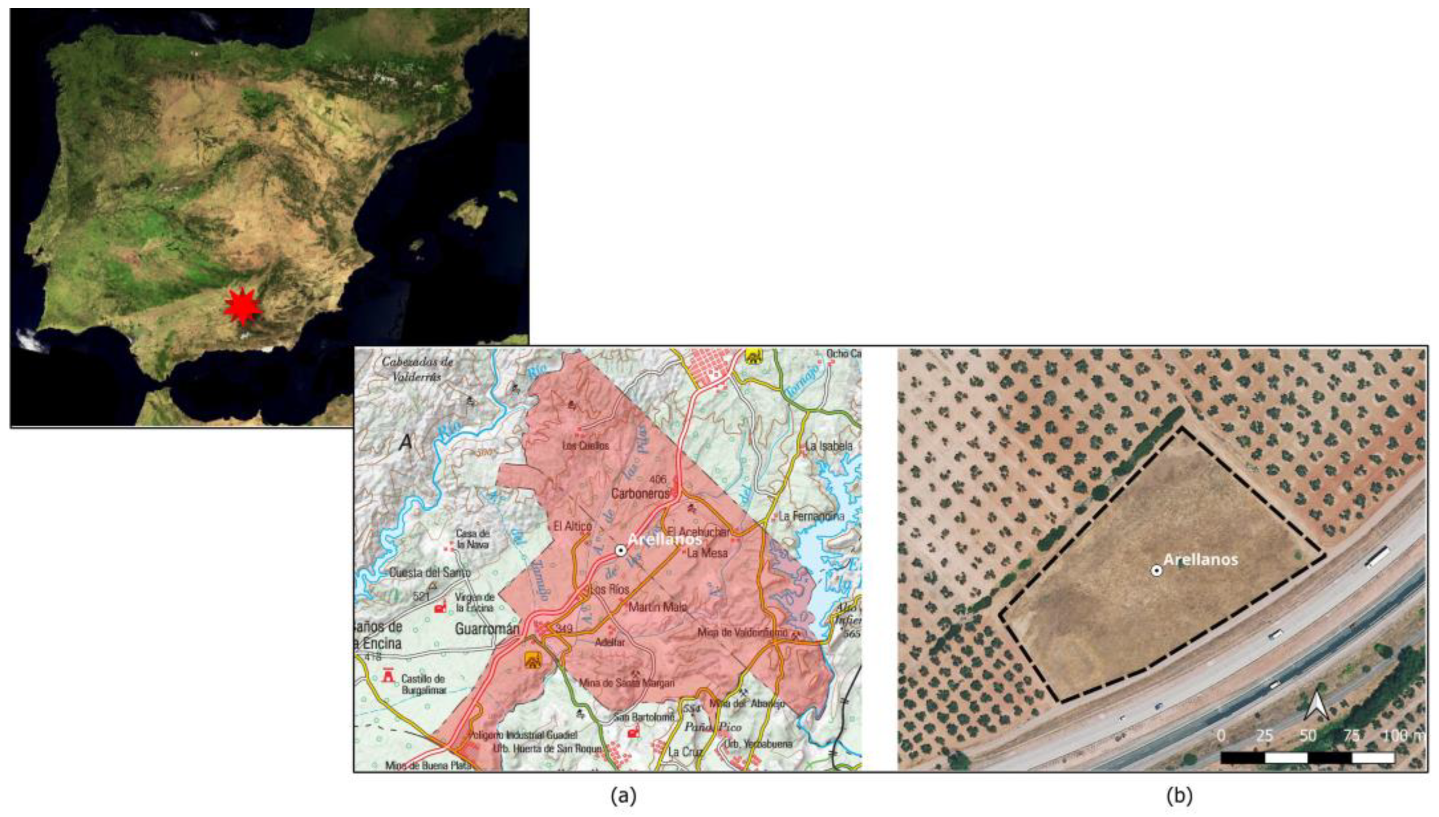
Figure 2.
Illustrates the DEM generated from the photogrammetric flight, modified with the following visualization parameters in QGIS: Brightness: -6, Gamma: 0.70, Contrast: 40, Saturation: 0, Color ramp: Cividis. Source: Authors' own work.
Figure 2.
Illustrates the DEM generated from the photogrammetric flight, modified with the following visualization parameters in QGIS: Brightness: -6, Gamma: 0.70, Contrast: 40, Saturation: 0, Color ramp: Cividis. Source: Authors' own work.
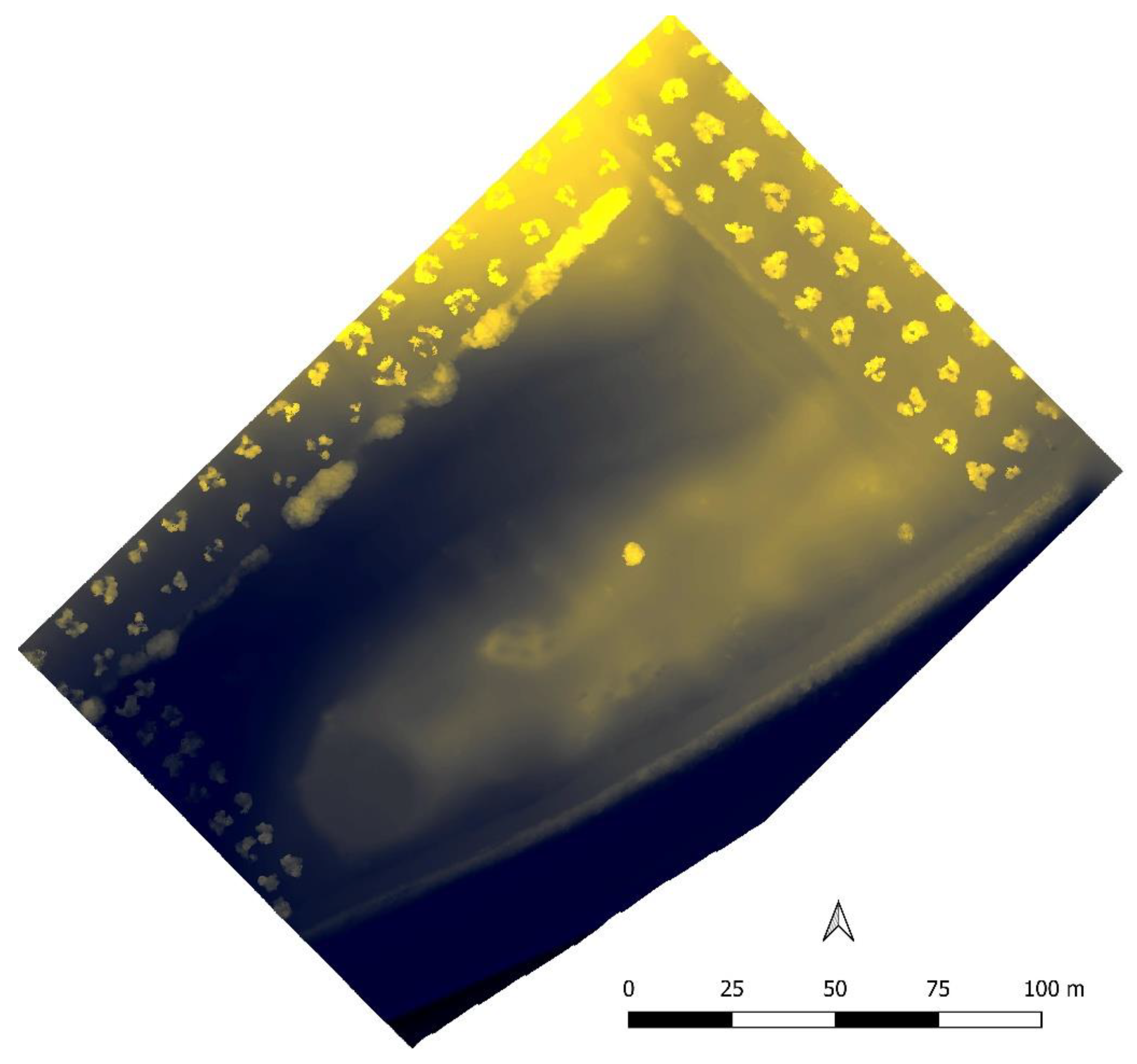
Figure 3.
Detail extracted from the PDF downloaded from the IGN's Digital Photo Library, specifically from the American Flight Series A orthophotography of the village of El Arellano. Source: Detailed extracted by authors from PDF downloaded from IGN’s Digital Photo Library.
Figure 3.
Detail extracted from the PDF downloaded from the IGN's Digital Photo Library, specifically from the American Flight Series A orthophotography of the village of El Arellano. Source: Detailed extracted by authors from PDF downloaded from IGN’s Digital Photo Library.
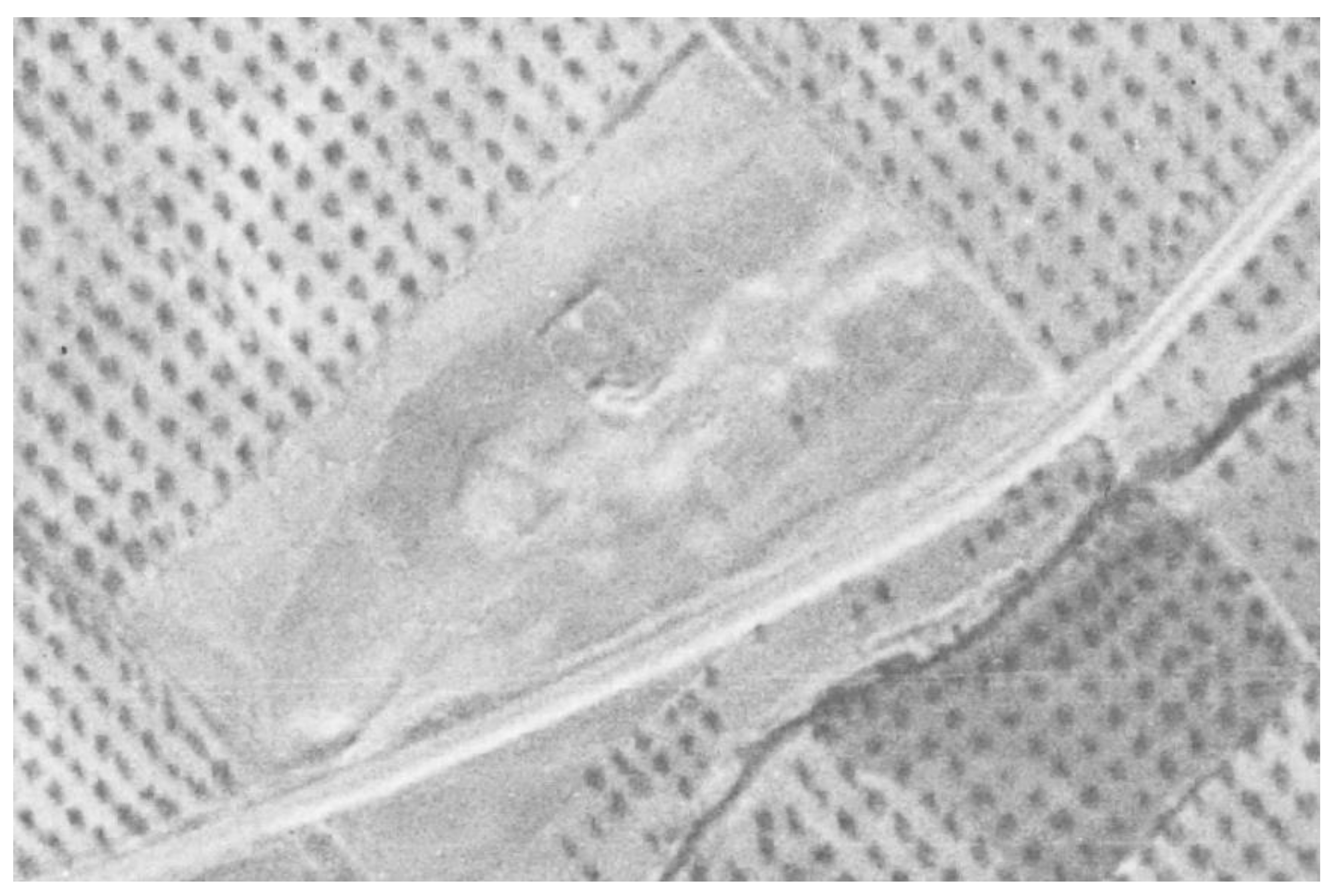
Figure 4.
Detail of the georradar from the Geodetection Unit of the University of Cadiz used in the described work..Source: Authors' own work.
Figure 4.
Detail of the georradar from the Geodetection Unit of the University of Cadiz used in the described work..Source: Authors' own work.
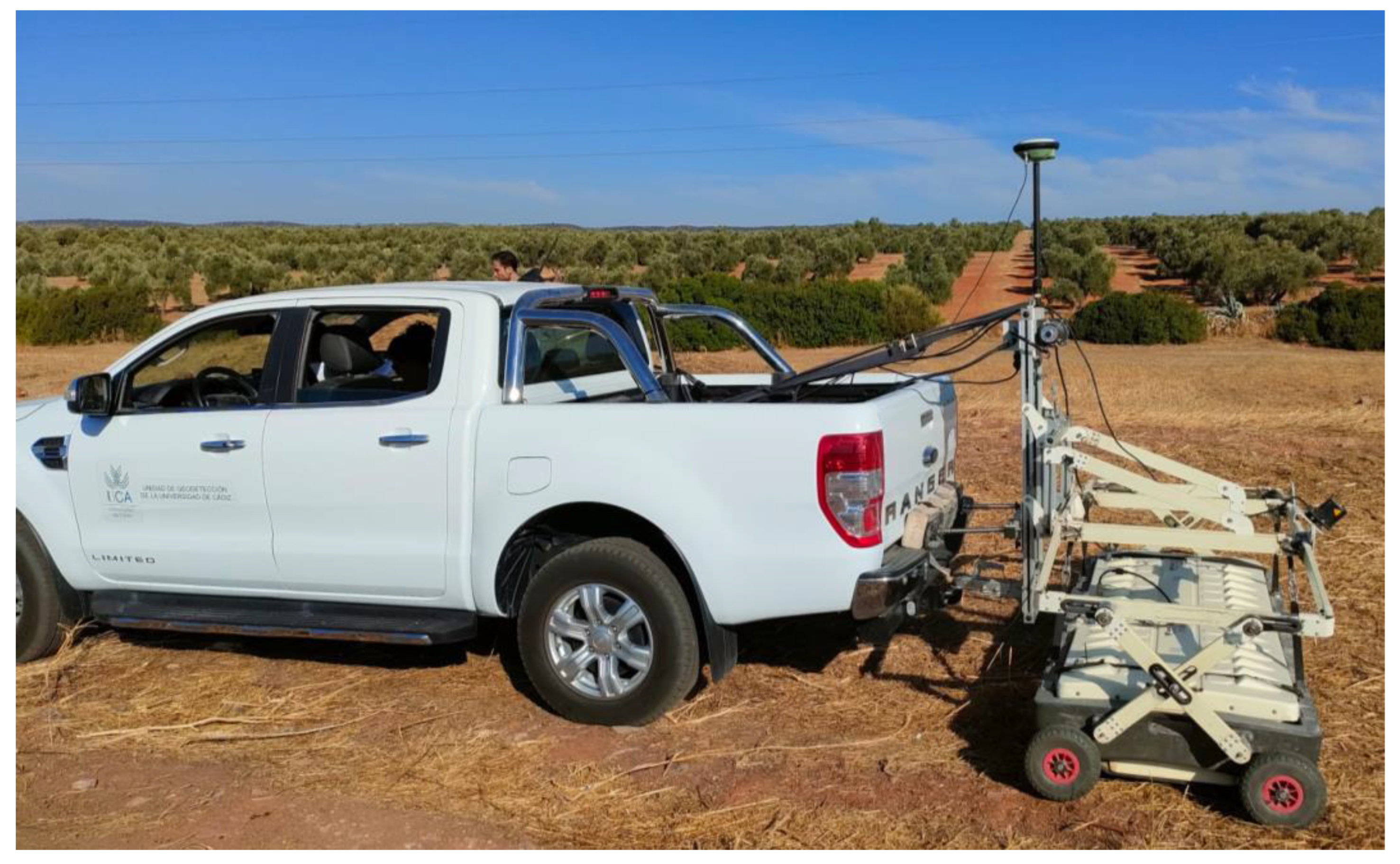
Figure 5.
Geographical Map of the New Settlements of Sierra Morena de Joseph de Ampudia y Valdes (1794-1797). Fuente: Archivo General Militar de Madrid, J-2/21. https://bibliotecavirtual.defensa.gob.es/BVMDefensa/es/consulta/registro.do?id=127554.
Figure 5.
Geographical Map of the New Settlements of Sierra Morena de Joseph de Ampudia y Valdes (1794-1797). Fuente: Archivo General Militar de Madrid, J-2/21. https://bibliotecavirtual.defensa.gob.es/BVMDefensa/es/consulta/registro.do?id=127554.
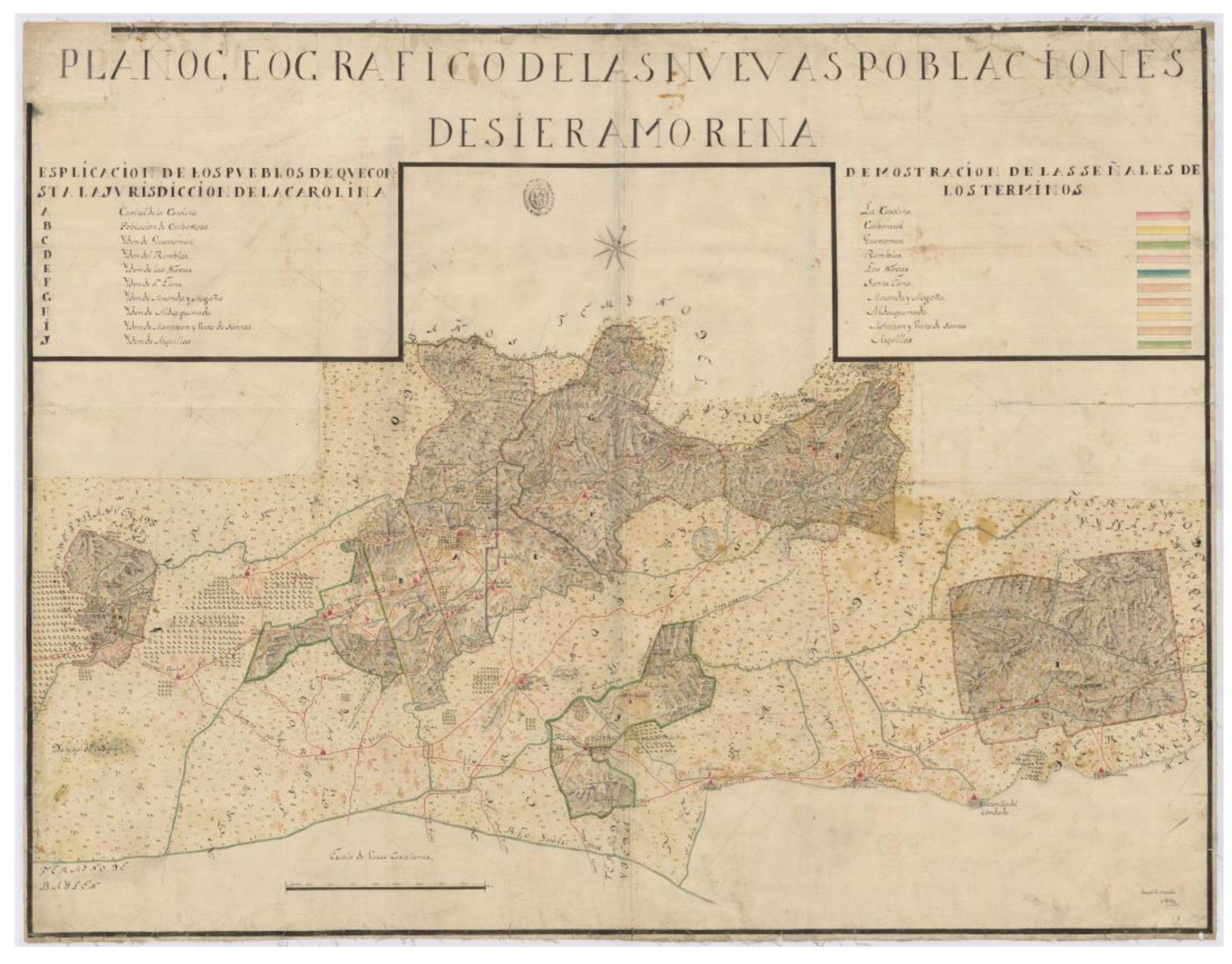
Figure 6.
Historical photographs analyzed: (a) Serie A. (b) Serie B. (c) Interministerial. (d) Vuelo Nacional. (e) OLISTAT. (f) SIGPAC. Source: Authors' own work.
Figure 6.
Historical photographs analyzed: (a) Serie A. (b) Serie B. (c) Interministerial. (d) Vuelo Nacional. (e) OLISTAT. (f) SIGPAC. Source: Authors' own work.
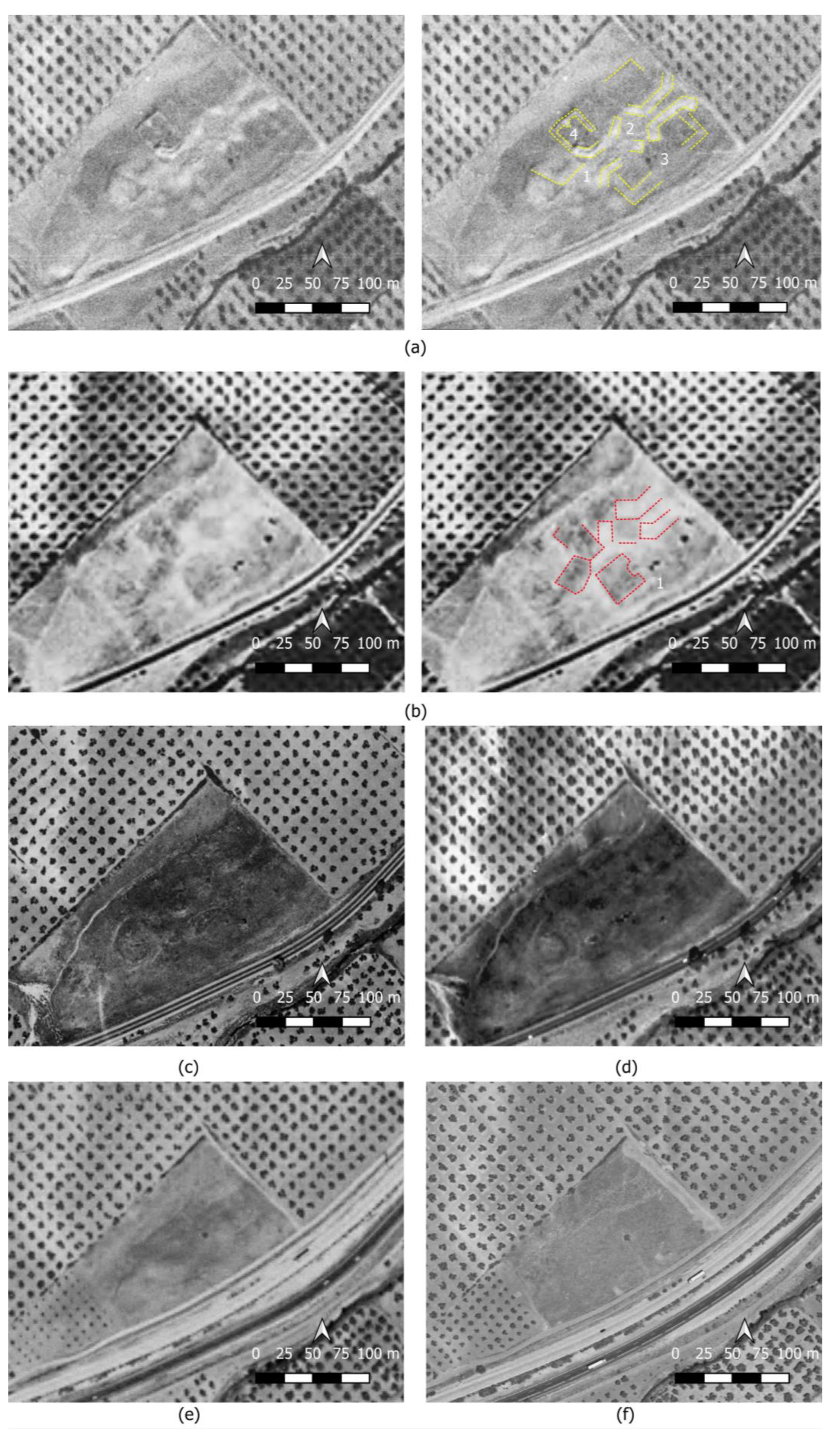
Figure 7.
Orthophotography acquired with the drone, along with a detailed view of the specific area utilized for taking surface measurements. Source: Authors' own work.
Figure 7.
Orthophotography acquired with the drone, along with a detailed view of the specific area utilized for taking surface measurements. Source: Authors' own work.
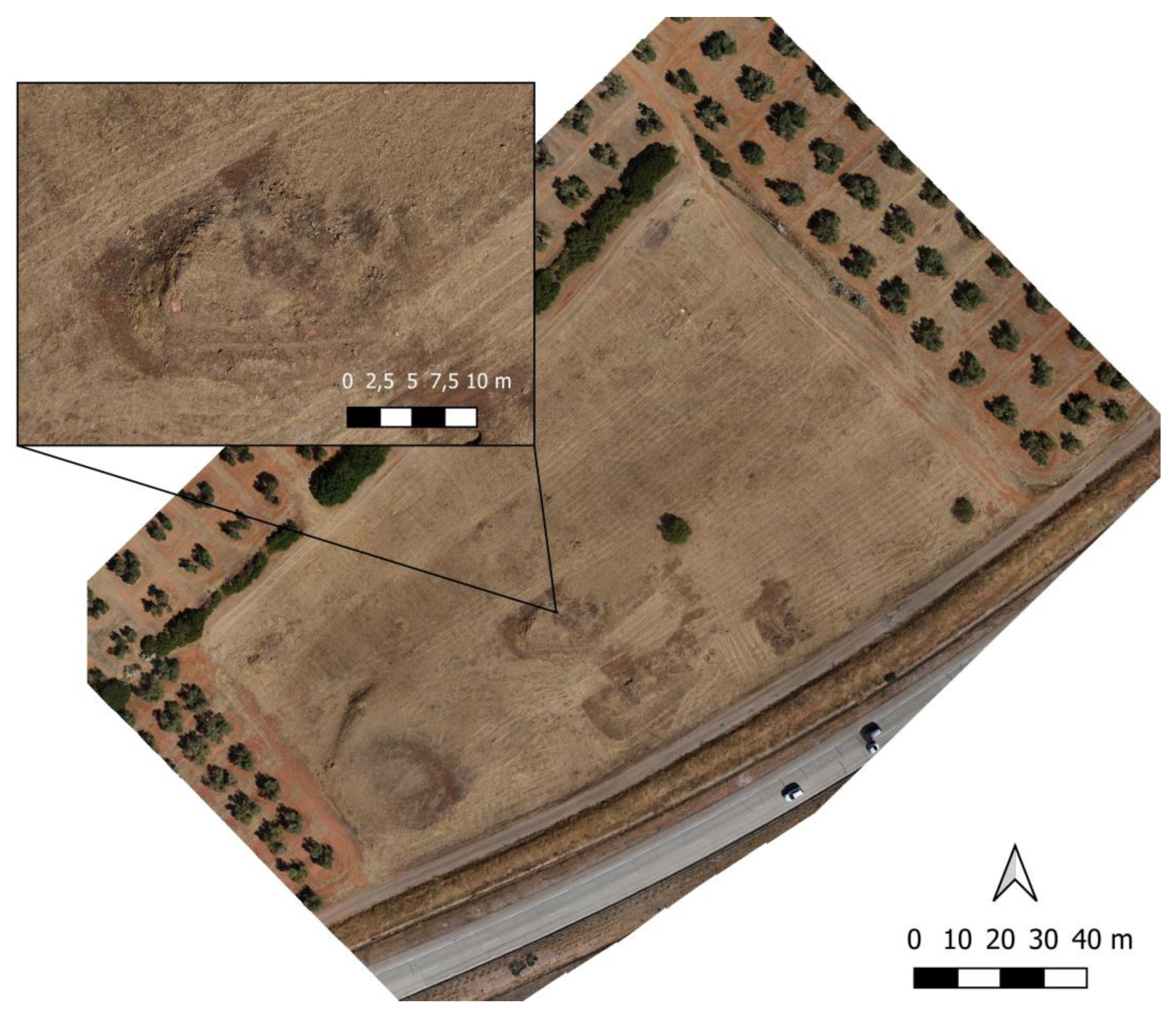
Figure 8.
Digital Elevation Model (DEM) generated from the drone photogrammetric flight. The detailed inset clearly shows the layout of one of the dwellings documented on the surface. Source: Authors' own work.
Figure 8.
Digital Elevation Model (DEM) generated from the drone photogrammetric flight. The detailed inset clearly shows the layout of one of the dwellings documented on the surface. Source: Authors' own work.
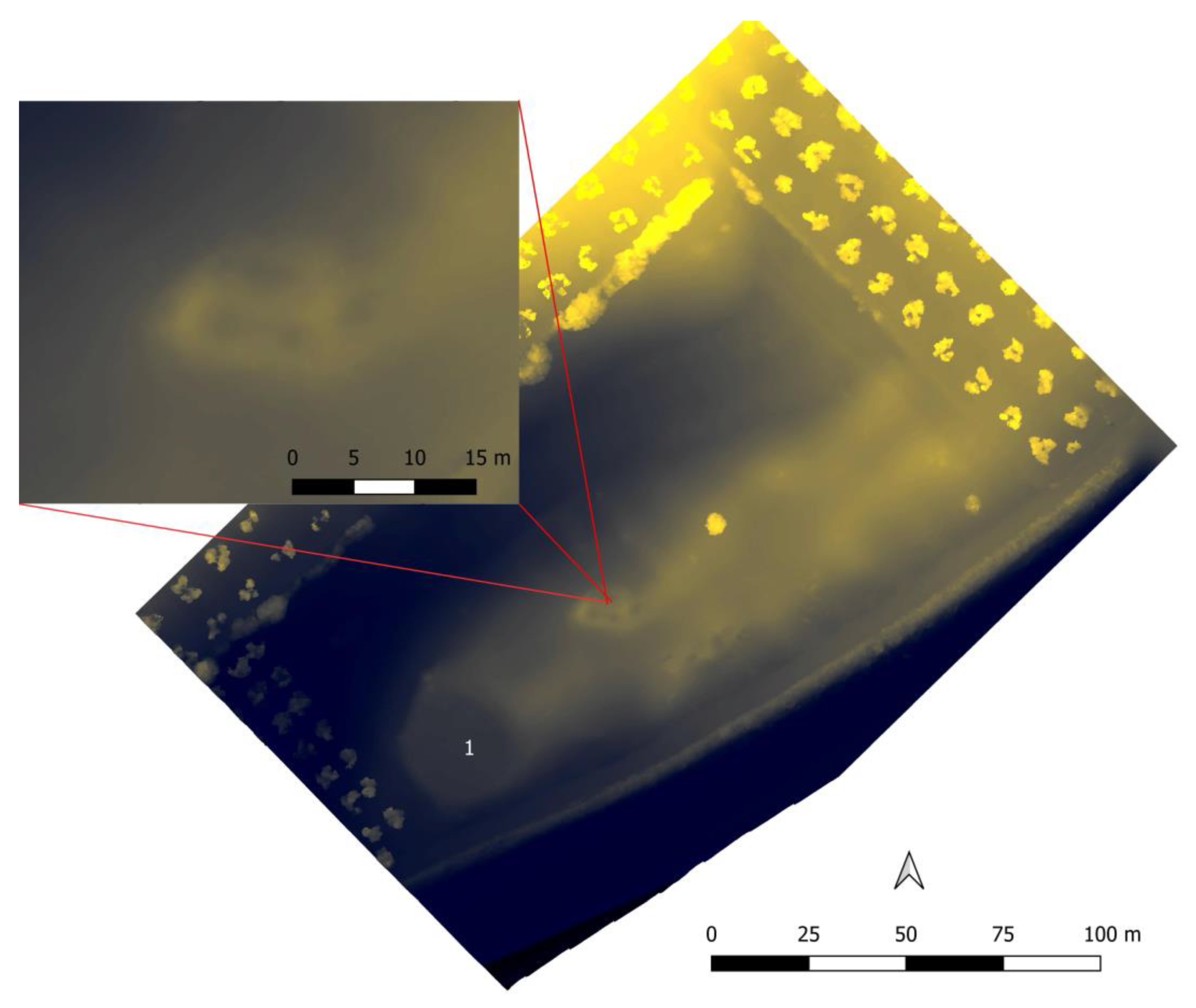
Figure 9.
Results obtained after analysing the DEM (Digital Elevation Model) generated by the photogrammetric flight using the RVT plugin in QGIS.. (a) SVF-A_R10_D16_A315_Allow (b) SLOPE (c) MSRM_F_M0.0-20.0_S2. Source: Authors' own work.
Figure 9.
Results obtained after analysing the DEM (Digital Elevation Model) generated by the photogrammetric flight using the RVT plugin in QGIS.. (a) SVF-A_R10_D16_A315_Allow (b) SLOPE (c) MSRM_F_M0.0-20.0_S2. Source: Authors' own work.
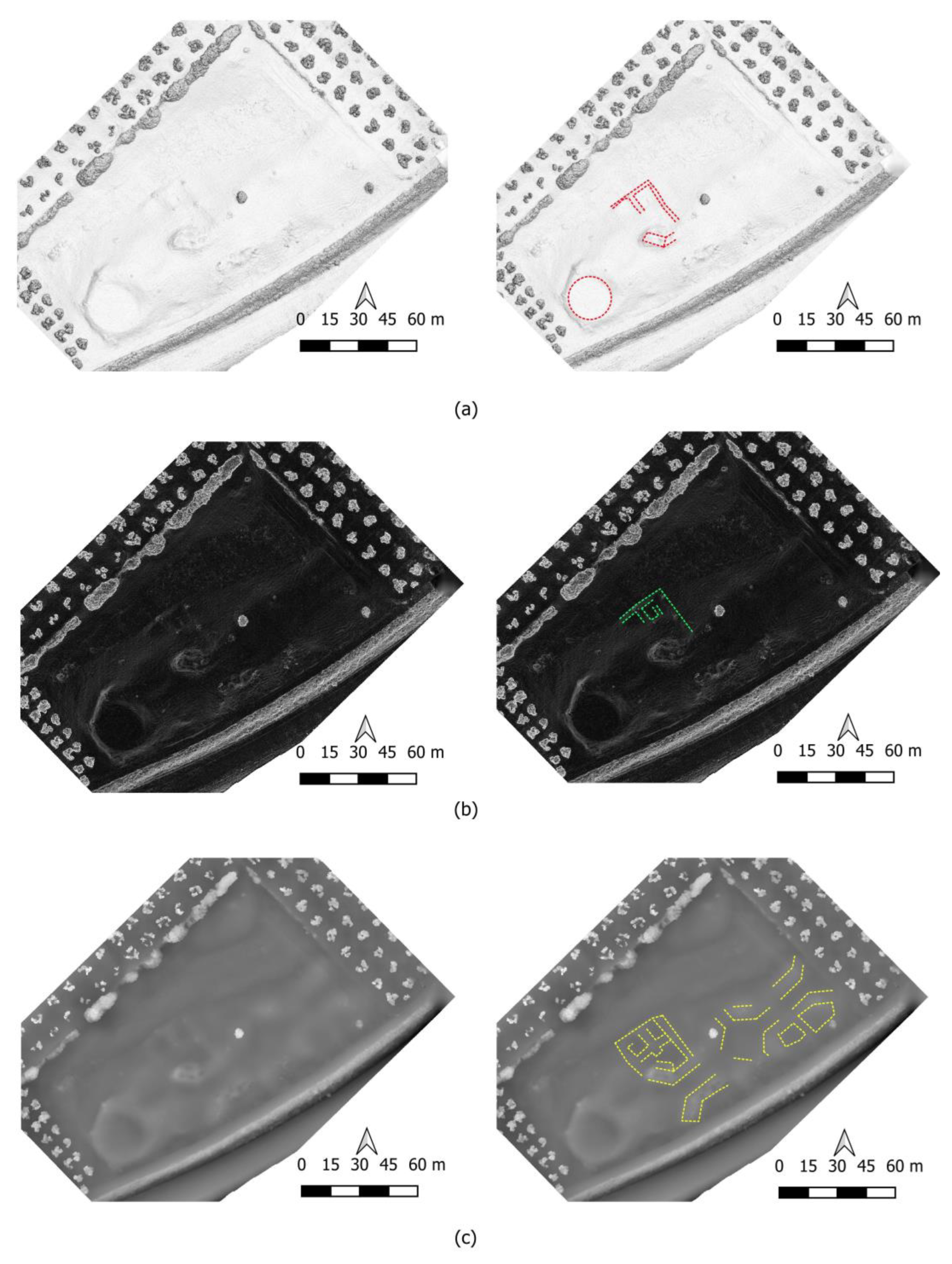
Figure 10.
70 cm depth slice of El Arellano village, with a particular focus on the central area. (a) Detail of dwellings 1 and 2. (b) Detail of dwellings 3 and 4. Source: Authors' own work.
Figure 10.
70 cm depth slice of El Arellano village, with a particular focus on the central area. (a) Detail of dwellings 1 and 2. (b) Detail of dwellings 3 and 4. Source: Authors' own work.
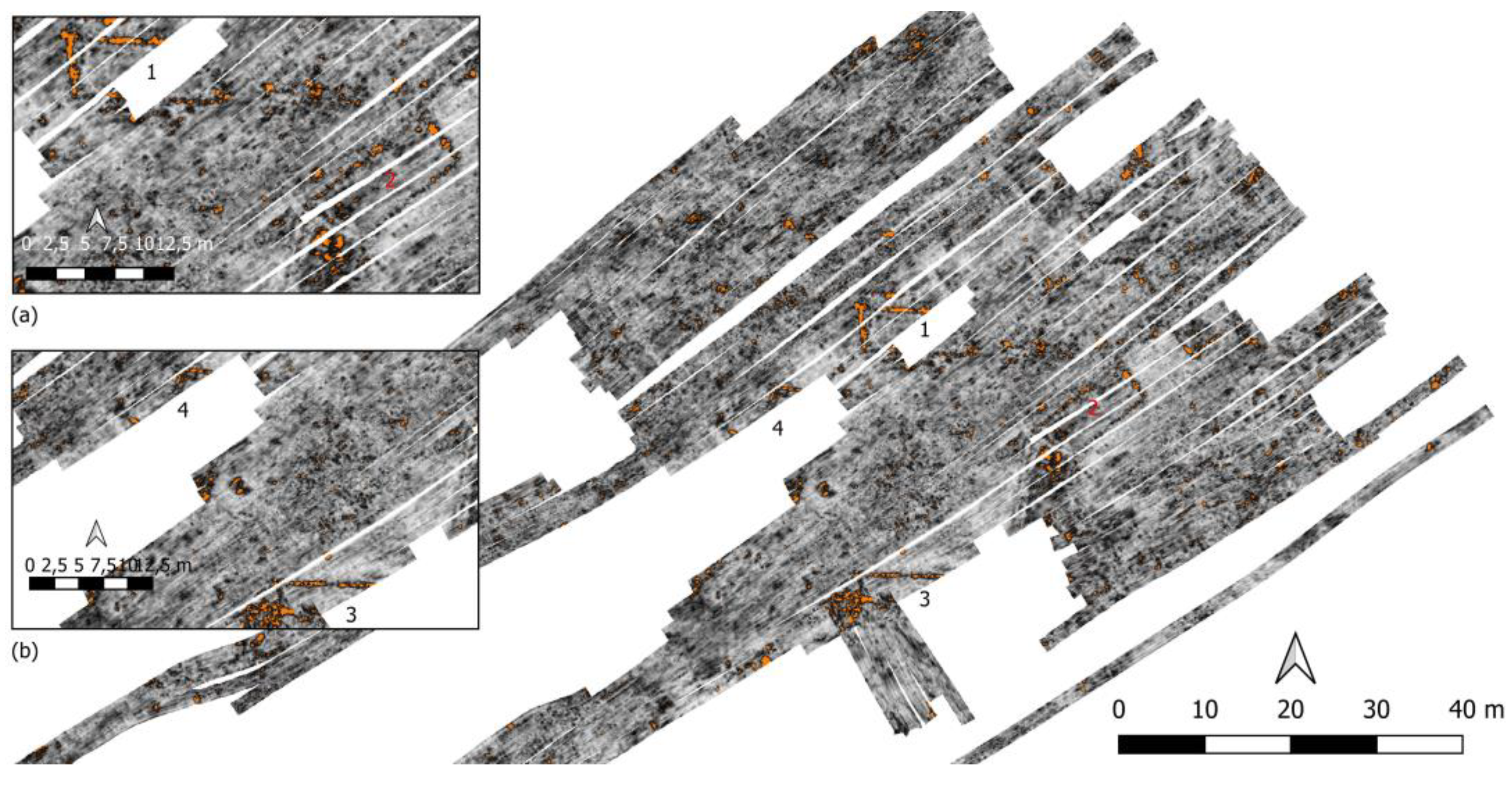
Figure 11.
Results obtained during the archaeological prospection. Source: Authors' own work.
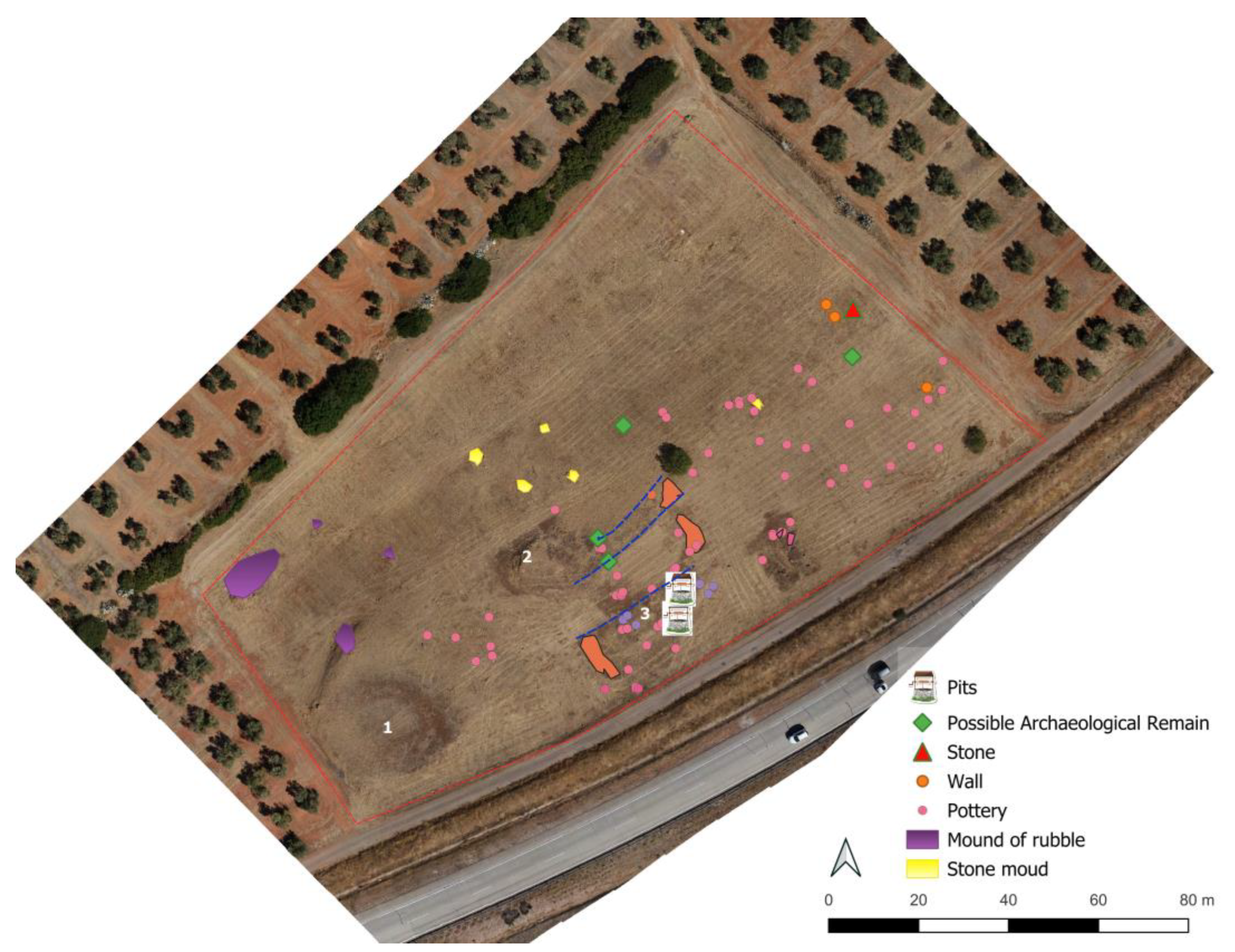
Figure 12.
Thresing floor. (a) Thresing floor on aerial ortophotography made with drone. (b) Proposed plan.
Source: Authors' own work.
Figure 12.
Thresing floor. (a) Thresing floor on aerial ortophotography made with drone. (b) Proposed plan.
Source: Authors' own work.
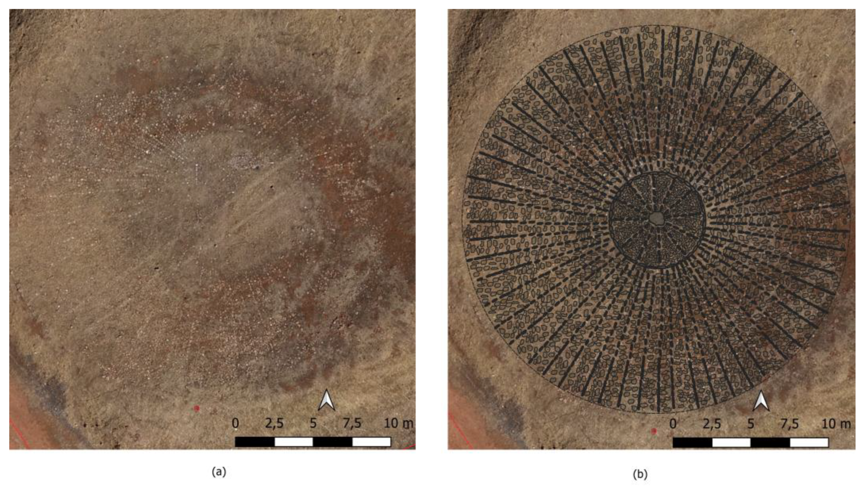

Table 1.
Datasets used in this study.
| NAME OF FLIGHT | DATE OF FLIGTH | FORMAT | DOWNLOAD AVAILABLE | SOURCE |
|---|---|---|---|---|
| Interministerial | 1973-1986 | ECW JP2 | Yes | CNIG Download center |
| Nacional | 1980-1986 | ECW | Yes | CNIG Download center |
| Americano Serie A | 1945-1946 | No | Digital Photo libray | |
| Americano Serie B | 1956-1957 | No | Digital Photo library & WMS |
1 Archivo
General Militar de Madrid, J-2/21 |
|
2 Archivo Histórico Municipal de Guarromán, Legajo 449, 2.1.4.10. Censos: vivienda y población (1897-1991); Legajo 692, 3.3.4. Amillaramientos (siglo XIX). |
|
3 Pedro Matías Polo de Alcocer was intendant of the New Settlements of Sierra Morena and Andalusia between 1814-1820 and 1823-1835. Anticipating the suppression of the Intendancy of New Settlements upon the death of Ferdinand VII of Spain, he wrote this Memoria Histórica as a report to support the continuity of the fuero system of Sierra Morena, which was in force between 1767 and 1835. |
|
Disclaimer/Publisher’s Note: The statements, opinions and data contained in all publications are solely those of the individual author(s) and contributor(s) and not of MDPI and/or the editor(s). MDPI and/or the editor(s) disclaim responsibility for any injury to people or property resulting from any ideas, methods, instructions or products referred to in the content. |
© 2025 by the authors. Licensee MDPI, Basel, Switzerland. This article is an open access article distributed under the terms and conditions of the Creative Commons Attribution (CC BY) license (http://creativecommons.org/licenses/by/4.0/).
Copyright: This open access article is published under a Creative Commons CC BY 4.0 license, which permit the free download, distribution, and reuse, provided that the author and preprint are cited in any reuse.


