Submitted:
24 July 2025
Posted:
25 July 2025
Read the latest preprint version here
Abstract
Coastal public spaces in large Euro-Mediterranean cities represent critical zones of negotiation between land and sea, where ecological fragilities, infrastructural pressures and social demands intersect. Grounded in the concept of the urban amphibious condition, this study explores the spatial and functional complexity of city–sea interfaces through the development of CITI4SEA, a multidimensional framework designed to assess coastal public spaces across diverse urban contexts. By applying it to seven major coastal cities, the research constructs a comparative lens capable of highlighting patterns that transcend national boundaries. The analysis reveals the emergence of cross-national clusters, formed not by geographical proximity but by shared planning logics, morphological features and degrees of ecological and social integration. This comparative perspective allows to understand how different cities respond to similar coastal challenges, offering insights into the structural asymmetries that affect accessibility, environmental quality and public use. Beyond mapping differences, the study contributes an operational methodology for evaluating littoral transformations within the broader framework of Integrated Coastal Zone Management and Maritime Spatial Planning. In doing so, it proposes a replicable tool that can inform strategies rooted in local realities—where adaptability, equity, and spatial specificity guide the evolving relationship between cities and the sea.
Keywords:
CITI4SEA
; assessment framework
; coastal public space
; urban regeneration
; coastal management
; city-sea interface
; urban amphibious
; Euro-Mediterranean basin
; urban coasts
; large coastal cities
1. Introduction
1.1. Regenerating Urban Waterfronts for Satisfying Socio-Environmental Demands
Coastal areas are undoubtedly a fundamental part of the urban system, as they are the point of contact between land and marine ecosystems, with significant theoretical and operational implications.
Waterfronts represent a dynamic threshold between these two elements, within which the ecological and functional transition process develops in complex and heterogeneous ways, depending on the composition of the settlements and, by extension, of the coastlines themselves [1].
In some cases, there is no continuity between the coast and the water due to the presence of high cliffs or reefs; in other cases, the transition is more gradual and takes place through beaches, dune areas or low-lying stretches of shore.
These areas are home to extremely productive and diverse ecosystems, which have historically provided food resources, bases for trade and privileged places of settlement. The value of coastal areas has grown in proportion to economic development and demographic pressure, generating increasing competition between different uses and interests. Therefore, tensions related to integrated resource management emerge with greater intensity along urban coastlines, where often competing functions and environmental dynamics converge [2].
As a result, the management and development of waterfronts must consider the specific features of littoral areas, prompting reflection on planning and governance issues [3,4]. This complexity is further amplified by the fact that the processes that affect the quality of the shore often originate far from the coast itself: decision-making procedures that appear unrelated to the urban maritime context actually impact the way coastal spaces are used, as in the case of land uses that alter water regimes or cause erosion [5].
At EU level, this complexity of governance for coastal areas has been interpreted in documents such as the European Parliament Recommendation on Integrated Coastal Zone Management (ICZM) of 2002.
The ICZM approach is one of the first holistic formulations to recognise the interdependence between geospatial, ecological, socio-economic, functional and cultural factors, emphasising the urgent need to address the threats posed by climate change and growing anthropogenic pressure on the urban seashore [6]. While acknowledging the lack of a single definition of coastal zone, which varies according to environmental, management and functional factors in different geographical contexts [7], the stated objective of the document is linked to the importance of ensuring accessibility to coastal public spaces, enhancing their aesthetic, social and recreational aspects and recognising the tensions between the natural dynamics of the coastal system and human activities.
These indications have been gathered by the Maritime Spatial Planning (MSP) tool: the purpose of the framework is to regulate coastal and maritime uses in relation to cumulative anthropogenic impacts [8]. MSP adopts an inclusive approach, taking into account existing urban and management structures, without replacing them but integrating them, and valuing the needs of local communities [9].
The most markedly strategic approach of the tool aims to address the challenges related to functional competition between maritime and coastal uses in a systemic manner, proposing adaptive solutions that act simultaneously on the environmental and socio-economic fronts.
The document also introduces the definition of land-sea interactions, i.e. all those processes involving natural phenomena and human actions with a mutual influence on both the marine and terrestrial margins of the coast: this concept amplifies the inherent complexity of coastal planning, but also unfolds the existing interconnection between coastal ecosystems and the users who inhabit, enjoy and transform them [10].
In this context, it makes sense to interpret urban coasts as a territorial interface, i.e. as a space of systemic interrelation between two ecological, physical and functional domains: specifically, the notion of city-sea interface identifies the contact area between the urban fringe and the coastal marine environment: this is an area of strong ecological and socio-functional interrelationship, where the two domains influence each other, generating complex phenomena of mutual evolution and adaptation, also considering the environmental impacts that contemporary coasts are facing [11].
One of the criteria underlying this concept is the high population density, which acts as a catalyst for functions and intense relationships between the community and the water within heavily man-made areas, creating a continuum of community and spatial uses and dynamics.
Due to the evolutionary complexity of contemporary waterfronts, the structure of the city-sea interface is characterised by a high degree of flexibility, influenced by significant socio-cultural, economic and productive flows, as well as ecological and environmental dynamics defining its conformation over time and determine its adaptive capacity [12,13].
On this basis, the concept of the city-sea interface can be viewed through the lens of the urban amphibious condition, a theoretical concept, originally inspired by Land [14] and further developed in this study, which describes the ability of coastal cities and their communities to adapt to the overlapping dynamics and pressures of urban and maritime environments. This framework therefore represents a space of functional overlap between residential, productive, tourist, infrastructural and cultural uses, whose position at the boundary between land and sea becomes a strategic asset for both landscape enhancement and waterfront design, while also being increasingly subject to the risk of market-driven transformations that may reduce its collective and ecological value.
Among the key spatial attributes of such interfaces is their functional permeability, understood as the capacity of waterfronts to support physical and visual access, pedestrian continuity, and the coexistence of multiple uses and flows. In this sense, the coastal edge operates not as a rigid boundary but as a porous and adaptive zone [15,16]. The urban amphibious condition does not correspond to a fixed morphological type; rather, it reflects a condition of adaptive coexistence, in which coastal public space becomes the place where social demands, ecological pressures, and community practices are continuously negotiated.
Contemporary waterfronts also have significant social and cultural value: the areas of contact between cities and the sea host socio-recreational activities that make them highly attractive spaces and harbingers of identity values. These areas have not only important economic, productive and logistical implications within urban systems, but also reflect the community’s demands for the enjoyment of places of great landscape value, especially in densely populated areas.
As Ritchie [17] highlights, littoral places like beaches have long embodied a global archetype of freedom, leisure, and desire, fueling social pressure on coastal areas, especially in large cities. As a result, anthropogenic and ecological pressures are gradually reaching peaks that must be taken into account in planning strategies and decisions.
The city-sea interface is therefore a highly strategic space for understanding socio-ecological transition processes, as it is where intense interactions between community, environmental and functional systems take place. As a result, this unique space is a privileged location for studying the transformations triggered by systemic phenomena such as climate change and globalisation, the effects of which are evident on the local scale. From this perspective, this concept becomes crucial for addressing contemporary environmental challenges and integrating adaptation and mitigation policies into planning processes [18]. Considering the high expectations of citizens for coastal areas, the development of littoal cities, especially the largest ones, will face increasing challenges typical of widespread urbanisation.
The increase in extreme weather events – from sea level rise to flash floods – emphasises the urgency of a strategic and methodological approach to enhance the flexibility and resilience of the urban amphibious condition, generating direct impacts on the liveability of coastal populations. Indeed, although located in areas that benefit from the ecological and cultural advantages of proximity to the sea, these communities are exposed to environmental risks and ecosystem pressures [19].
In this scenario, urban coastal management cannot ignore the littoral adaptive and regenerative function, nor the vulnerabilities and growing demands of a wide range of stakeholders attracted by the potential of these territories [20].
In the Euro-Mediterranean context, the dynamics described above are particularly acute, as it is one of the areas with the highest settlement, tourism and infrastructure pressure. Its environmental fragility, exacerbated by extreme climate events that affect its coasts and combined with its economic and cultural importance, requires the adoption of advanced strategies for the sustainable management of coastal resources [21].
In this sense, the Mediterranean city-sea interface stands out as a key reference point for understanding and promoting coastal urban regeneration. In particular, public spaces facing the sea are acquiring a central role as mediators between defence infrastructure and environmental quality, between places of socialisation and equal access to the sea, making waterfronts true catalysts of urban resilience [22].
However, coastal urban regeneration involves balancing social, environmental and economic needs, which are often in tension with each other. In emerging economies, this conflict is intensified by the need to respond quickly to the essential needs of growing populations. The enhancement of the city-sea interface therefore requires an integrated assessment of ecosystem services, considering not only commercial aspects but also environmental, cultural and recreational ones, in order to promote the well-being derived from the social use of coastal urban space [23].
Building on these premises, it becomes essential to further investigate how the city–sea interface can be understood not only as a physical definition of coastal areas but as a space capable of triggering urban and environmental change. In this view, coastal public space is approached as an active urban threshold — a space of connection and transition which defines socio-ecological and cultural values and not only spatial dimensions in the field of landscape and waterfront regeneration [24,25].
In this framework, thresholds are understood as dynamic and hybrid spatial interfaces where ecological systems, urban infrastructure and social practices intertwine. Indeed, they represent zones of negotiation between land and sea, public and private use, ecological function and urban form—where infrastructures, daily practices, environmental impacts and the demand for habitability converge, shaping the design and governance of coastal public space.
From this perspective, the notion of coastal habitability moves beyond the idea of service provision or physical access to space, encompassing the potential for environmental and social co-existence, also in marginal spaces shaped by infrastructure, climate challenges and spatial conflict [26]. Accordingly, the city–sea interface can be read as a relational and ecological structure, capable of generating new spatial configurations through adaptive and integrated interventions: it is not only a morphological concept, but also a contested space where competing claims intersect. Addressing this complexity requires going beyond purely design-oriented approaches and engaging with critical issues of environmental justice, spatial equity and socio-ecological transition [27,28,29].
In the light of the above, this study lays the groundwork for a comparative reflection on the evolving role of coastal public spaces in large Euro-Mediterranean cities. This conceptual framing informs the subsequent development of a methodological tool for assessing urban-maritime thresholds.
1.2. Research Background and Main Objective
Starting from an increasing international focus on the sustainable regeneration of urban waterfronts, several recent studies have focused on the comparative analysis of coastal case studies, with the aim of exploring methods, critical issues and opportunities in the planning and management of public spaces facing the sea.
Among these, Dal Cin et al. [30] address the transformation of European waterfronts – with particular reference to the cases of Hamburg and Rotterdam – as a strategic response to sea level rise. The study adopts an integrated approach between infrastructural adaptation and spatial quality, emphasising the urgency of adaptive planning for combining environmental resilience and public use of coastal urban spaces.
The contribution by Dubinina et al. [31] offers a theoretical and design-oriented reflection on the concept of permeability, analysing various European examples in which continuity between cities and water has been promoted through flexible and inclusive spatial solutions. The study emphasises the experiential and symbolic dimension of blue spaces, suggesting that the quality of coastal public places also lies in its accessibility, transparency and interactivity.
From a metropolitan perspective, the study by Erdem & Terzi [32] applies an evaluation grid to the complex spatial and functional articulation of the district of Bosphorus, Istanbul, highlighting the differences between the various areas of the waterfront in terms of accessibility, facilities, vegetation and potential uses. The methodological approach, based on measurable indicators, allows for a systemic reading of spatial inequalities within the same city.
The research of Tommarchi [33], which has a more historical and comparative approach, reviews fifty years of transformations in North American and European waterfronts, highlighting the recurrence of gentrification and spectacularisation of public space, often to the detriment of its original social function. The comparison of case studies shows how redevelopment rhetoric often conceals processes of socio-territorial exclusion.
Finally, Jelovac [34] focuses on the Mediterranean context, proposing a strategy for coastal regeneration based on a balance between cultural heritage, economic development and ecological resilience. Montenegro’s experience serves as a model for understanding the tensions between tourism, conservation and sustainable governance, opening up operational opportunities for other coastal cities in Southern Europe.
Collectively, these contributions illustrate a rich spectrum of theoretical and methodological approaches to the transformation of coastal urban spaces — from infrastructural adaptation and symbolic design to historical critique and integrated planning. At the same time, they underscore a broader need for spatially grounded and comparative approaches capable of capturing the complexity of public coastal interfaces in large urban contexts. This need resonates with current debates on socio-ecological transition and spatial justice, which increasingly call for integrative perspectives linking spatial configuration, environmental performance and social accessibility.
Building on this growing body of literature, this contribution is rooted in the findings of the research project Re-SEA-ourcing CITY. City-sea interface as a resource for people: urban regeneration in the context of ecological transition, developed within the international Galileo 2021 programme and aimed at studying the habitability of major Mediterranean coastal cities in relation to the liveability of their waterfronts, in the wake of increasing socio-environmental pressures on the coast that undermine its quality and accessibility.
The research, carried out by a multidisciplinary team from Italian and French academic institutions, aimed to compare large coastal cities, focusing on the significant number of users who both experience and exert complex pressures on their coastal environments. It also acknowledges the importance of socio-ecological transition and spatial justice, addressing how unequal access to coastal public spaces intersects with environmental vulnerabilities in Mediterranean cities.
Urban coasts bring numerous benefits to these cities in economic, environmental, energy and tourism-recreational terms, even though their significant heritage and landscape assets are exposed to human and ecological risks and challenges linked to coastal development itself [35]. Over time, this has led to the dynamic development of waterfronts, including reclamation of useful space from the sea, in order to accommodate the multitude of old and new littoral functions and, at the same time, to face external risks, although these strategies have left their mark on the coastal-maritime ecosystem and have not always satisfied underlying demands from the society [36,37].
Within the framework of the Re-SEA-ourcing-CITY research project, therefore, the goal was to explore urban scenarios related to the evolution of coastal interfaces, investigating issues such as the adaptation to climate change, the equal accessibility to ecosystem services and littoral spaces, the sustainable port development and the ecological transition, through the lens of socio-recreational use of coastal space, which is the focus on which this paper will specifically delve.
Building on this, the main objective of this article is in fact analysing how different cities of the Euro-Mediterranean basin deal with the planning of their city-sea interfaces. These areas denote various types of vulnerabilities, as explained above: climate change, complex social demands, littoral fruition not always compatible with the geomorphological characteristics of the urban coasts. These factors have required specific management and planning approaches and methodologies over the last fifty years.
The aim is to provide a synthetic overview of current planning approaches to coastal urban interfaces within the context of the study, analysing whether these cities and their coastal interfaces actually respond in planning terms to the growing demand for proximity open spaces intended for social use, in relation to the main municipal websites and related documents, through the elaboration of an assessment tool that may be useful to critically compare public spaces along urban littorals.
The originality of this research lies in the construction and application of a comparative analytical framework for assessing coastal public spaces in large Euro-Mediterranean cities. By combining functional typologies, ecological indicators, and coastal usability indicators — including equipment density and direct access to the sea — the study contributes to the ongoing debate on urban maritimity, understood as the spatial, functional and cultural relations defining the city’s link to the sea [38].
To this end, the contribution introduces CITI4SEA (City–Sea Interface Typological Indicators for Spatial–Ecological Assessment), a comparative framework designed to evaluate coastal public spaces through a set of multidimensional indicators and typological interpretation criteria. The framework aims to support both analytical and planning processes along urban maritime thresholds, addressing the lack of integrated, data-driven assessments at the urban scale within ICZM and MSP contexts.
On this basis, the structure of the article is organised as follows:
- Section 1 has outlined the theoretical background, introducing the city–sea interface as a socio-ecological and spatial category;
- Section 2 presents the methodological approach, including the construction of a dataset of Euro-Mediterranean coastal cities and an evaluation grid applied to selected waterfront public spaces, in the frame of the CITI4SEA approach;
- Section 3 illustrates the results of the comparative analysis, focusing on seven major urban cases in France, Spain and Italy;
- Section 4 discusses comparative outcomes and their implications for coastal governance, with particular attention to ecological performance, functional systems, and alignment with ICZM and MSP frameworks, by proposing cross-comparisons between the various case studies identified;
- Section 5 highlights the main outputs of this contribution, providing indications on their possible applicability.
2. Methods and Materials
2.1. Geo-Database of Euro-Mediterranean Coastal Cities: The Empirical Base of the CITI4SEA Framework
The research methodology adopted in this paper builds on and operationalises the framework developed in the volume Urban Coasts in Socio-ecological Transition: A Methodological Framework to Support Planning and Management of the City-Sea Interface by Pistone [39], where the city–sea interface was first addressed as a multidimensional planning and analytical category.
In the present study, this model is further refined and extended, particularly in its geo-spatial component, through the comparative analysis of case studies selected for their exposure to intense socio-environmental pressures within complex geographical settings, such as those of the Euro-Mediterranean basin.
The methodological approach described below consists of two main phases.
- The first phase consists in identifying case studies by collecting data on Euro-Mediterranean coastal cities, which are compiled into specific research geo-dataset;
The second phase involves applying an evaluation grid aimed at studying the main characteristics of the coastal public spaces in the selected cities and comparing them with each other.the study identified the main coastal cities in the Euro-Mediterranean basin, considering as such urban settlements with at least 20,000 inhabitants and direct access to the sea [40].
In this regard, the cities were classified in four different categories as follows:
- Minor cities, with a total population of less than 50,000 inhabitants;
- Medium cities, where the number of inhabitants ranges between 50,000 and 200,000;
- Large cities, ranging between 200,000 and 500,000 citizens;
- Major cities, characterised by population values of more than 500,000 inhabitants.
In line with the abovementioned criteria, the geo-dataset [41] includes 149 cities, divided among eight EU Member States, namely Spain, France, Italy, Slovenia, Croatia, Greece, Cyprus and Malta. The highest concentration is found in Italy (67 cities), followed by Spain (36 cities), France (16 cities) and Greece (18 cities).
Croatia has only six cities that meet the requirements, while Cyprus has just three. The small island of Malta and Slovenia, with a coastline of just 46 km, have two and one eligible cities respectively, in line with their limited maritime perimeter.
From a demographic point of view, the sample is characterised by a prevalence of minor cities (50 cities, accounting for 32% of the total) and medium cities (85 cities, representing 57% of the entire dataset): this aspect is consistent with the Mediterranean coastal urban structure, characterised by small settlements along articulated shorelines.
The remaining part of the sample consists of 6% of large cities (only 9), and 5% of major cities (just 7) (Table 1).
Another parameter considered is the presence of a port in the cities analysed. Specifically, we have considered:
- Logistics and production ports, linked to shipbuilding and to the presence of coastal industrial facilities;
- Commercial ports, intended as poles characterised by container terminals and traffic
- Tourist ports, for passenger transport by ferry and high-speed boat, with the possible presence of cruise terminals;
- Leisure ports, with docks and marinas for private boats, like yachts or sailing boats.
The aggregated data shows that each of the coastal cities analysed has recreational boating infrastructure, confirming the strong relationship between the coastal landscape and recreational boating. About half of the ports in the sample appear to be equipped for touristic functions, with 77 cities having tourist ports; similarly, 78 cities host commercial traffic in their harbours. In contrast, logistics and production functions are much less common, limited to slightly less than a third of the cases (46 cities).
The study of the distribution of the various port functions also showed that some countries have more complete facilities. Italy and Spain are the countries with the highest number of cities equipped with all categories of harbours with 19 logistics and production ports, 32 commercial ports, 26 tourist ports and 67 leisure ports along the Italian coast and with 10 logistics and production ports, 17 commercial ports, 15 tourist ports and 36 leisure ports along the Spanish coast.
France also stands out for the widespread presence of leisure facilities (16 out of 16 cities), but has a lower concentration of marinas, commercial and logistics ports, with less than half of its harbours used for these purposes.
Greece, on the other hand, has a balanced distribution of all port categories, especially in relation to tourism and leisure (both present in 18 ports) and commercial (in 12 ports), reflecting the historical extensive network of inter-island maritime connections.
Malta and, particularly, Cyprus, despite having few urban centres above the reference demographic threshold, both have a well-developed infrastructure system in their main cities: the former mainly from a tourist and leisure point of view, while the latter shows a comprehensive infrastructural endowment across all port categories.
Slovenia, with a single eligible coastal city (Koper), also hosts all four port functions despite its limited maritime extent (Table 2).
There is also a correlation between the demographic location of Euro-Mediterranean cities and the categories of harbours found. The number of different port types increases in proportion to urban size, although there are significant exceptions. Minor cities, despite their small size, have a high incidence of leisure ports, while commercial (17) and tourist (18) ports are less common, while only 7 harbours serve logistics and productive purposes. Medium cities show the widest functional variety: 27 cities have a logistic-productive port, 45 have a commercial harbour and 44 host tourist boating facilities. Finally, about half of the 9 large cities offer logistics and productive port functions, while commercial and tourist services are available in almost all of them. As for the ports of major cities, although there are only 7, they all offer the four functional types (Table 3).
Based on the geo-dataset described above, a subset of seven major cities was selected for in-depth analysis. Considering that all the analysed cities have direct access to the Mediterranean Sea, the selection was guided by the following two main criteria:
- A resident population exceeding 500,000 inhabitants, to ensure relevance in terms of urban scale and socio-spatial complexity;
- The presence of all four identified port categories, as a proxy for maximum functional pressure exerted on the city–sea interface in terms of incoming and outgoing flows.
This structured geo-dataset, built on demographic thresholds and port infrastructure classification, provides a robust empirical basis for the implementation of the CITI4SEA framework. By identifying a broad and representative of Euro-Mediterranean coastal urban contexts — and subsequently narrowing the focus to seven major cities with the highest degree of infrastructural complexity and functional pressure — the study creates the conditions for a targeted yet comparative evaluation.
As a result, the geo-dataset does not merely serve as a background for selection but constitutes the structural foundation of the methodological approach adopted, supporting the next phase of analysis, which assesses the spatial, ecological and functional qualities of coastal public spaces through a multidimensional evaluation grid.
2.2. Evaluating Coastal Public Spaces: The Operational Structure of the CITI4SEA Framework
In line with the objectives of the study, the focus was placed specifically on the coastal public spaces of major cities, namely the seven Euro-Mediterranean urban centres with more than 500,000 inhabitants, each equipped with the four identified port categories. This choice, already introduced in Section 2.1, forms the core of the case study analysis within the CITI4SEA framework.
This selection is justified by the strategic role that these cities play in the Mediterranean urban-coastal system, both in terms of population size and infrastructure complexity and socio-environmental pressure [42,43]
The concentration of port infrastructure and intensive flows reinforces the strategic relevance of public spaces in ensuring inclusive waterfront access and adaptive regeneration, especially in light of the urban transformation processes undertaken over the past fifty years.
In order to analyse these contexts in a systematic and comparative manner, a multidimensional evaluation grid has been developed to collect qualitative and quantitative data on public spaces along the coast. The grid is divided into six macro-criteria, each composed of quantitative and qualitative indicators [44] (Table 4).
- The geographical extent measures in common quantitative terms the analysed area, to ensure consistency in spatial comparisons;
- The typology of uses studies each site according to a functional classification, accompanied by a study of the prevailing and often overlapping uses of these places, in order to explore the multifunctionality of the areas;
- The period and stage of implementation of the various public spaces, indicating the actual realisation of projects and contextualising them in terms of time, also in relation to broader regeneration processes;
- The equipment provision is intended to survey street furniture, sanitary facilities, sports equipment, refreshment points and cultural hubs, with a score that summarises the density of public facilities available [45];
- The criterion of green areas examines the ecological and landscape quality by studying, with reference to the degree of greenery and the complexity of the existing vegetation, in order to define a quantitative measure for comparative studies through a quantitative density index [46];
- The bathing areas consider both the percentage of the area intended for directly enjoying the sea and the different types of access to the water (natural beaches, artificial platforms, hybrid solutions) [47].
Each indicator included in the assessment framework – from functional facilities to ecological quality, from the presence of multiple uses to the design scale – has been selected based on its capacity to shed light on aspects that are relevant to understand the transformation of coastal public spaces into liveable spaces.
These indicators do not act as isolated variables but are configured as fields of interrelation through which to interpret the internal coherence of urban transformations and their ability to respond to the major issues of ecological transition, spatial inclusiveness and socio-functional regeneration.
In this sense, the evaluation grid serves a dual purpose: it is both an operational tool for mapping public space quality under high anthropogenic pressure, and a conceptual device aligned with current research on adaptive planning, aiming to foster the co-production of environmental and social value. As such, it embodies the analytical heart of CITI4SEA and enables a structured interpretation of the evolving relationship between urban space and coastal dynamics.
Overall, the grid not only guides the observation and data collection but also builds a comparative framework capable of highlighting specific features and critical issues in the design and management of public spaces along city-sea interfaces.
Then to sum up, in relation to the choice of case studies, as far as Slovenia, Croatia, Greece, Malta and Cyprus are concerned, the urban coasts of these states do not present cases of coastal cities whose size respects the minimum parameters defined for comparison with other Euro-Mediterranean settlements and their main existing coastal projects.
In view of the subject of the study, it is therefore considered appropriate to examine the case of Marseille in France, the cases of Barcelona, Valencia and Málaga in Spain and the cases of Naples, Palermo and Genoa in Italy (Figure 1).
3. Results: Assessment of Coastal Public Spaces in French, Spanish and Italian Main Littoral Cities
The assessment presented in this section is grounded in the application of the evaluation grid developed in the above-mentioned CITI4SEA methodological framework, structured around six criteria and twelve indicators.
This framework enables a comparative and multidimensional reading of coastal public spaces, combining spatial, functional, ecological and infrastructural dimensions into a coherent set of analysis.
The following subsections provide synthetic yet articulated descriptions of the urban contexts in which the analysed coastal public spaces are embedded, offering a concise overview of their main spatial, ecological and social features. Each case is interpreted through the lens of the evaluation grid, allowing for the emergence of specific configurations that combine spatial structure, ecological performance and accessibility to the sea. Schematic summaries and visual comparisons further support the discussion, offering a grounded basis for cross-case benchmarking and thematic clustering.
The indicator outcomes are not presented as isolated metrics but are critically interpreted in relation to the broader urban-maritime systems to which the spaces belong, considering local governance frameworks, infrastructural constraints and cultural-historical trajectories. This approach ensures that the analytical reading of each site is firmly grounded in the complexity of its territorial context, avoiding purely descriptive or technical framings.
The evaluation was applied to 23 selected public spaces located within the city–sea interfaces of the seven major Euro-Mediterranean coastal cities, chosen for their demographic size and port complexity. Each site was analysed individually, and the indicator-based structure allowed for the identification of both recurrent patterns and site-specific characteristics.
Through this structure, the study provides a solid analytical foundation for understanding the differentiated modalities through which coastal public spaces are shaped, governed and experienced across large Euro-Mediterranean cities.
3.1. Real Estate and Social-Driven Planning for Coastal Open Spaces in France: The Case of Marseille
Most of the French coastal surface is touched by the Atlantic Ocean to the west; however, an important Mediterranean littoral stretch connects the country to Spain and Italy. Although it is varied and multifaceted, its Mediterranean coastal strip has just one major coastal city meeting the research criteria: Marseille, with over 870,000 inhabitants [48], occupies a strategic position along the Euro-Mediterranean corridor, acting as a historical gateway between continental Europe and the southern basin.
Its urban fabric is deeply entangled with its maritime dimension, producing a highly stratified city-sea interface shaped by overlapping productive, recreational, environmental and speculative logics.
The articulated configuration of its shore reveals the layered legacy of port infrastructures, industrial enclaves, beaches, and reclaimed public spaces, as well as recent efforts toward social inclusion and ecological adaptation [49].
This complexity is evident in the city’s strategies of transformation. Large-scale interventions for public recreational areas in the Parc du Prado and Pointe Rouge in the southern part of the urban shore have combined resilience and accessibility to reshape the public waterfront.
The Prado coastal park, developed since the 1970s, covers over 400,000 m² extending three kilometres along the coast and was realised through land reclamation and beach nourishment aimed at mitigating coastal erosion, storm impact and pollution. Protected by rock revetments, the area consists of large public beaches, vast green spaces intended for sports and recreation and limited areas for commercial facilities [50].
This integrated system embodies qualities often associated with urban amphibious configurations, where resilience, multifunctionality and accessibility converge at the city-sea interface.
In continuity with the Prado beach park, the Pointe Rouge area is located, with its tourist harbour and shallow crescent-shaped beach of around 10,000 m². Between 2016 and 2020, a process of regeneration, aimed at removing illegal structures in the area, has introduced lightweight amenities and improved pedestrian mobility, reinforcing its role as an accessible leisure space for residents and tourists [51].
From a different perspective, the Euroméditerranée 1 and 2 national programmes represent instead the most ambitious port–city redevelopment initiative. Launched in 1995 [52,53], those plans combine real estate and cultural investments aimed at revitalising underused coastal districts in central sector of the littoral.
While the J4 pier was transformed into a “water square” hosting the MuCEM cultural hub and relevant heritage assets, such as the Fort Saint-Jean, the nearby Les Terrasses du Port shopping centre offers panoramic views of the cruise port and symbolizes the commercial ambition of the area.
A more socially grounded approach can be observed closer to the city centre at Plage des Catalans, a historic bathing area that has hosted recreational and sporting uses for over two centuries in its 6,000 m² of sandy surface. Recent projects aim to enlarge the beach and enhance its heritage features, including the ancient porticos and the 16th-century Tour Lazaret, while introducing two new public squares and relocating the volleyball courts to optimise spatial configuration. The ongoing process is following a participatory approach, through the dissemination of surveys to gather social desires [54] (Figure 2).
Moreover, just 100 metres offshore from this site lies the Musée Subaquatique de Marseille, a unique underwater sculpture park that transforms the marine environment into a hybrid cultural and ecological public space. The installation integrates artistic and environmental education: it represents a peculiar and innovative experiment in Europe, allowing social and sustainable fruition of the urban sea, stimulating cultural activities and monitoring the marine biosphere through special sensors integrated in the artworks exhibited below the water level [55].
Similarly, in the northern 16th Arrondissement, Parc de Corbière offers a local-scale solution for people to enjoy the sea. It occupies a former fishing area beneath a distinctive viaduct. With a surface area of 20,000 m², it includes terraced gardens and sandy beaches, benefiting from a favourable microclimate. The site, with its strong landscape potential, hosts a maritime sport centre for children and people with disabilities, but the proximity to port facilities, the presence of numerous private nautical clubs and the lack of a proper public mobility system still undermine the social and inclusive potential of the place (Figure 3).
The analysis of the main recent projects along the urban waterfront of Marseille reveals a complex and articulated system of coastal public spaces, where the coexistence of functional, social and ecological dimensions is evident.
The overall assessment highlights a diversified set of spatial types – including beaches, marinas, promenades and multifunctional urban parks – which collectively contribute to the permeability and inclusiveness of the city-sea interface. Despite some public spaces scoring lower in specific indicators, the overall littoral landscape offers a relatively balanced distribution of equipment and spatial configurations, which suggests that public access to the coastline remains a significant concern for urban strategies in Marseille.
Among the six criteria analysed, Plage du Prado stands out for its high performance across most indicators, particularly in terms of Quantitative density of equipment and Percentage of vegetated surface, with a score of 4 out of 5 and 65% respectively. The area combines formal recreational infrastructure, open lawns, and beach environments, effectively supporting both socialisation and ecological permeability. Similarly, Pointe Rouge denotes a high functional flexibility (even if the ecological richness is significantly lower), indicating the careful listening to different usage needs. These two areas confirm the southern stretch of the Marseille waterfront as a key zone for the integration of landscape, leisure and social use.
The central waterfront zone, represented by the Euromediterranèe interventions (such as the MuCEM area), shows a certain degree of planning articulation, allowing for significant relational and cultural functions. The area of J4 Pier reflects this strategic pattern, confirming its role as a social and symbolic space, albeit with lower environmental permeability. The evaluation grid suggests anyway a design that is more oriented towards an event-based framework rather than ecological or community-led uses, although citizens usually enjoy these spaces and this stretch of coast in a more independent and not always authorized way.
On the other hand, Plage des Catalans and Parc de Corbière reveal a more critical condition. The former has a wide range of functional activities, even if the spatial dimension is quite reduced (even if a project is ongoing to provide more space for sea-related uses), while the latter, despite its significant green coverage (45% namely 9,800 m2), suffers from partial disconnection from the city core and weak urban integration, especially in terms of accessibility. Nevertheless, the ecological quality of the place highlights its potential as a fundamental socio-environmental asset for the city-sea interface.
Overall, the Marseille waterfront appears to embody a pluralistic and adaptive concept of waterfront, where different typologies respond to heterogeneous demands. Despite some criticalities in the northern sector, the evaluation grid demonstrates a clear institutional awareness of the multifunctional nature of coastal public space and its value as a mediation between the urban and maritime dimensions (Table 5).
3.2. Major Events and Local Projects for the Development of Coastal Public Space and Urban Beaches in Spain: Barcelona, Valencia, Málaga
Similarly to France, Spain also presents a western oceanic side, but has a greater surface area of its coastal strip that is touched by the Mediterranean sea. It has also a denser coastal interface along which there are three urban polarities with more than half a million inhabitants [56]. For this reason, this paper will describe the actual city-sea interfaces of Barcelona, Valencia and Málaga, as port cities with important socio-recreational features.
Barcelona is the largest and most populous coastal city among the Spanish study cases (approximately a 1,730,000 inhabitants in 2018). The transformation of its waterfront has been strongly influenced by large-scale public events, which reshaped the coast into open and iconic multifunctional public spaces. This makes Barcelona a particularly complex case, where planning initiatives have been combined with cultural and social programs to improve access and quality of life along the urban littoral.
The urban coast of Valencia, with its 791,000 inhabitants, follows a peculiar development, since it was founded away from the sea and it expanded towards the maritime zone only in more recent times: progressively, the urban development has saturated the available coastal areas, even if the integration with earlier littoral villages has not always been homogeneous, because of their a strong local identity; this characteristic clearly determines the direction in which the planning progress of public places along the coastal interface is directed.
Málaga is one of the most important tourist destinations in Spain: the city has 571,000 inhabitants and is an appealing destination for a wide variety of users that compose its peculiar coastal community; its evident touristic inclination pushes the development of the coast from a recreational point of view, even if this implies a smaller quantity of proximity public spaces for the local society.
3.2.1. The Effect of Large Events on the Open Spaces of Barcelona’s Coastal Interface
Barcelona’s urban coastline has undergone profound transformations since the second half of the 20th century, becoming a paradigmatic case of culture- and event-led planning. From a degraded and privatised shore in the 1960s–1980s, shaped by industrial uses and ecological neglect, the city progressively reoriented coastal development toward public use, social inclusion and international visibility. The political transition of 1979 marked a shift towards community-driven urbanism and spatial justice, aligning coastal planning with broader goals of civic accessibility and environmental regeneration [57].
A key turning point came in 1986, when Barcelona was officially selected to host the 1992 Olympic Games. Although urban and coastal transformation had already begun, the event catalysed strategic interventions by injecting national and regional resources into an integrated vision of city–sea reconnection. The interventions included a general infrastructural improvement, enhancing accessibility to the coastal interface, and the creation of leisure and sport spaces, applying a holistic approach to open the city to the sea and distribute public facilities and services along the urban shore [58].
In this sense, the transformation of Port Vell has thus generated a multifaceted coastal recreational area. In particular, the Passeig Maritim, a former degraded space mainly dedicated to productive uses, gives now aesthetic but also social consistency to the urban coastline, thanks to its pedestrian area allowing a greater littoral usability, also from a landscape point of view [59].
Moreover, the Passeig Maritim promenade constitutes a link between the Olympic Village and the popular Barceloneta area (Figure 8), with its homonymous beach, characterised by a high degree of accessibility to the sea also for users with reduced mobility, while the bathing space is equipped for sport activities (Figure 4).
However, it must be considered that these planning actions are influenced by private funds that mainly direct the evolution of the city-sea interface towards entrepreneurial and tourist purposes. The Barceloneta and Somorrostro areas, once informal settlements hosting up to 15,000 residents, have been reconfigured in a way that, despite enhancing liveability, has reshaped the area’s social composition [60,61].
This dynamic continues at the eastern margin of the city, where new developments like Diagonal Mar and Poblenou reflect a different, more market-driven phase. In the 1990s and early 2000s, industrial brownfields were converted into high-end recreational and residential areas, strongly oriented towards affluent users and global tourism [62].
Simultaneously, the 2004 Fòrum de les Cultures event introduced a large coastal platform of about 200,000 m² in a former working-class district. While rooted in public initiative and cultural intent, the project failed to ensure long-term inclusivity and functional vitality, as evidenced by widespread underuse and architectural obsolescence [63].
However, the Fòrum also introduced a unique public infrastructure: an 11,000 m² artificial bathing platform directly connected to the sea. This facility enables recreational marine use without a sandy beach and holds significant ecological value. Over 500 marine species, including fish, shellfish and seaweed, have been recorded in the area, underscoring its role as both leisure space and biodiversity reservoir [64].
The application of the evaluation grid for Barcelona confirms the city’s marked tendency to transform its waterfront through large-scale interventions, often conceived in connection with public or institutional events. All four analysed spaces – Barceloneta beach, Passeig Marítim, Diagonal Mar and Parc del Fòrum – are completed projects, showcasing a strong spatial articulation and a strategic ambition to enhance the city–sea interface through emblematic forms.
Among these, Diagonal Mar and Parc del Fòrum, developed between 1999 and 2004, stand out for their scale (143,000 m² and 200,000 m² respectively) and multifunctionality. Classified as parks, they integrate recreational, cultural, commercial, and exhibition functions. Both score 3 out of 5 in quantitative density of equipment, with an articulated infrastructure of urban furniture, refreshment points and cultural hubs.
Diagonal Mar stands out for its environmental features, with the highest percentage of green areas (45%, or 65,000 m²) and reaching a green density score of 3, thanks to a layered vegetative structure including trees, shrubs and low-growing vegetation. Parc del Fòrum, though more mineral in structure, still includes 52,000 m² of green spaces (26%) and achieves a density score of 2, confirming a partial yet meaningful integration of ecological elements within a heavily constructed coastal platform (Figure 5).
In contrast, Passeig Marítim and Barceloneta – both realised between 1987 and 1992 in view of the Olympic Games – reflect a different approach. Passeig Marítim, formally a promenade, shows a predominantly infrastructural character, with no vegetated surfaces (0%) and only a linear arrangement of trees (density score: 1). It scores 2 in equipment density, indicating a modest provision of facilities, mainly oriented to circulation and coastal access. Barceloneta beach, although devoid of green areas, performs strongly in terms of bathing use: 90% of its 35,800 m² are dedicated to sea-related activities (32,200 m²), and it supports diverse functions, from sports to refreshment services, scoring 3 in equipment density.
In comparison with the other Spanish cities analysed, Barcelona reveals a median percentage of green coverage (20.3%) and a green area density mode of 2, suggesting a more balanced distribution of vegetated space than in Málaga but lower than Valencia. In terms of bathing provision, Barcelona stands out, with Barceloneta’s figures raising the city’s average to 27.2%, the highest among Spanish cases. However, the average quantitative density of equipment across the four sites (3.6) is slightly lower than that of Valencia (4.0), indicating a more uniform but slightly less intensive facility provision.
Overall, Barcelona’s coastal development strategy emphasises visual impact, multifunctionality and spatial openness. Yet, the focus on large-scale, emblematic spaces often coincides with a limited ecological ambition in infrastructurally dominant sites, and a marginalisation of neighbourhood-scale or community-led projects. The evaluation confirms that while public accessibility and infrastructural upgrading have been largely achieved, the social and ecological diversification of the waterfront remains an area for future improvement (Table 6).
3.2.2. Reconnections Between City and Sea and Community Expectations in Valencia
Valencia’s city–sea interface reflects a historical process of reconnection between the inland city and its coastline. Originally detached from the shore, the city progressively extended toward the sea over the course of the 20th century, incorporating former fishing villages like El Cabanyal-El Canyamelar and Natzaret. However, the parallel expansion of the port infrastructure contributed to socio-spatial polarisation and environmental degradation, triggering processes of segregation in several coastal districts [65].
From the late 1980s, urban strategies began to address the coastal condition more explicitly. The 1988 PGOU introduced the idea of a “Balcón al Mar”—a strategic plan to reconnect urban fabrics and the sea via green infrastructure, cultural facilities and public open space. This ambition partially materialised through the 2004 implementation of a large-scale green axis and recreational park adjacent to the northern port boundary, designed to mitigate the infrastructural barrier of the harbour and enhance the social and ecological value of the area [66,67].
A second wave of transformation followed Valencia’s selection as host of the 32nd America’s Cup in 2003, which led to the creation of the Consorcio Marina de Valencia in 2007 to coordinate urban coastal planning. Within this framework, the development of the Marina Real Juan Carlos I in the early 2000s reshaped the seafront, with an explicit focus on public and community use. Although the Consorcio sought to limit tourist accommodation in favour of collective spaces, the evolution of the Marina inevitably influenced the social structure, raising concerns among long-standing residents about the transformation of the area’s identity and everyday life [68,69] (Figure 6).
From this point of view, it may be relevant to analyse the case of the coastal district of El Cabanayal, as previously mentioned, an 13th century fishing village nearby the actual Valencian port.
In the early 20th century, the district became increasingly integrated with the city, especially through the construction of Avenida Blasco Ibáñez to connect it with the municipality, while retaining its distinct spatial and social identity. Although the area was officially preserved in 1993 for its historical and cultural value, a 1998 development plan proposed to extend the avenue through widespread demolition, triggering economic pressures and threatening the district’s socio-cultural fabric [70].
A strong community response emerged, including widespread local activism aimed at defending the neighbourhood’s heritage and values. This mobilisation led the authorities, in 2015, to adopt an Integrated Sustainable Urban Development Strategy (ISUDS) specifically for El Cabanyal, developed through a participatory and interdisciplinary approach [71].
The district features a popular urban beach used mainly by local residents, though also equipped with tourist facilities. To balance these dynamics, a waterfront regeneration project was launched in 2023 with the goal of reinforcing local identity, limiting short-term rentals, and enhancing the area’s socio-ecological quality through green corridors and the redevelopment of Avenida Blasco Ibáñez.
Valencia’s city–sea interface highlights two clearly divergent approaches to coastal public space design, as demonstrated by the Marina Real Juan Carlos I and the El Cabanyal waterfront.
The Marina, covering 237,000 m², represents a large-scale, top-down intervention linked to major maritime events such as the America’s Cup. Its functional classification as a marina emphasises its orientation toward recreational, cultural, exhibition and port-related uses. The intervention is fully realised and highly equipped, with a quantitative density of equipment rated 4 out of 5, including urban furniture, refreshment points, sports facilities and cultural-recreational hubs.
However, this equipment richness is not matched by ecological performance: only 9% of the surface (21,700 m²) is vegetated, scoring 2 in quantitative density of green areas; moreover, bathing areas are not comprehended in this public space, even if it has to be considered that this case study is located very near to the urban main port. The predominance of paved and tree-planted spaces reflects a design more oriented towards visual impact and event hosting than everyday public use or ecological integration.
In contrast, the El Cabanyal waterfront—much larger at 1,432,000 m², over six times the size of the Marina—embodies a slower, community-driven process still under implementation since 2023. The functional mix is broader and more grounded in the local context, combining residential, commercial, recreational, cultural and bathing uses.
Despite being ongoing, the intervention already matches the Marina in equipment provision, with a density score of 4, and includes comparable infrastructure: urban furniture, refreshment points, sports facilities and cultural-recreational hubs.
From an ecological standpoint, El Cabanyal outperforms the Marina: 13% of the surface is vegetated (191,000 m²) and the structure of green areas includes both low-growing and tree vegetation, again scoring 2 in green density. Crucially, it also includes a significant bathing area of 233,000 m², equivalent to 16% of its total surface, characterised as natural beach—offering direct contact with the sea and fulfilling an essential urban function absent in the Marina.
These contrasts reveal a fundamental difference in planning rationales. While both sites score equally in public equipment provision, their underlying logics diverge: the Marina prioritises visibility, event-driven planning and design and port functionality, whereas El Cabanyal promotes ecological integration and community use through a more inclusive and participatory strategy.
The presence of a large bathing area, more extensive vegetation and a broader functional mixité in El Cabanyal marks a clear shift toward a planning approach oriented towards local users and teir enjoyment of public spaces. Thus, while maritime events have historically triggered major investments, only bottom-up mobilisation—like that seen in El Cabanyal—has succeeded in translating spatial transformation into socio-environmental inclusion (Table 7).
3.2.3. Tourist Influence on Recreational Activities Along the Málaga City-Sea Interface
Málaga is a city located along the Costa del Sol, on the southern side of Mediterranean Spain, and represents one of the main tourist destinations related to bathing of the country. It is the second largest Spanish coastal city for number of tourists, hosting an average of 1.3 million visitors annually, of which around 60% come from other countries; it is also considered the urban destination with the highest tourist growth in Spain [72].
From a morphological point of view, the urban coastline is characterised by sandy beaches, one of the main socioeconomic and landscape cornerstones of the city.
The case of Pedregalejo, a former fishing village in eastern Málaga, illustrates the evolution of bathing areas to meet changing recreational needs. Since the 1980s, the district has gradually shifted toward a tourist-oriented character, with the coastline reshaped through inlets and breakwaters to protect the narrow shore and create a system of pocket-beaches. Despite its decentralised location, it now serves as a popular destination for both residents and visitors [73].
Westwards from Pedregalejo beach, there is a further element of coastal sociality, namely the Baños del Carmen. This is a fairly small area equipped for bathing, whose name recalls the old thermal baths built in 1918 as a leisure area for the high society of the time.
Since 2010, a process of extension of the current beach area has been officially approved, with the installation of breakwaters and the coastal connection with the nearby beach of Pedregalejo, as well as the implementation of the vegetated spaces of the site, in order to improve its usability with new facilities for cultural and sports functions [74].
Málaga’s relevance within the Mediterranean basin is also linked to its port and its role as a hub for goods and passenger traffic. In order to encourage porosity between the port infrastructure and the urban core, seeking to balance their values in favour of the community, the recreational area of Palmeral de las Sorpresas was developed, a space of about 20,000 square metres located within the harbour area, as a hinge with the city. Inaugurated in 2011, it is characterised by a long sun-shading structure and by the presence of green areas and spaces for recreation in contact with the sea: the boundary with the areas destined for logistical activities is clearly marked by glass barriers that do not, however, interrupt the visual enjoyment of the water resource; on the other hand, cycle mobility is limited to certain specific areas, due to the port regulations in force.
The Palmeral de las Sorpresas is connected to another green space within the local city-sea interface: the Parque de Málaga is a 30,000 square metres vegetated area, composed by bicycle and pedestrian paths and public gardens available for the local population. The area also serves as a green filter between the heart of the city and the port area, acting as an important element within the littoral green-blue infrastructure.
In both cases, however, the use of green areas near the coast suffers from strong tourism pressure due to their central location, even though they constitute a valid example of planning integration between urban greenery, the city and the sea (Figure 7) [75].
The comparative reading of the four study areas in Málaga confirms the coexistence of differentiated models within its urban waterfront, each responding to specific spatial positions, planning frameworks and user demands. The CITI4SEA assessment shows how these spaces express distinct balances between bathing, green infrastructure, and cultural-recreational functions.
Pedregalejo beach, located in the eastern part of the city, stands out for its exclusive focus on bathing activities. All its 24,000 m² surface is dedicated to sea-related uses (100%), the highest proportion among the analysed sites. It also reaches a high equipment density (score 4), with the presence of refreshment points, sanitary services and basic urban furniture, confirming its consolidated identity as a popular leisure destination. However, the site lacks significant green areas, scoring only 1 in green area density.
Baños del Carmen, with a more limited extension (4,600 m²), expresses a hybrid character. Although it is still undergoing renovation, it already hosts a diversified set of facilities, achieving the maximum score in equipment provision (5), thanks to the combination of sports services, refreshment points and a cultural hub. Its bathing capacity is also relevant (60% of the surface, equal to 2,750 m²), while its vegetated area reaches 9%, structured with tree vegetation and scoring 2 in green density.
This site demonstrates an attempt to requalify a coastal heritage location through integrated design, though its compact size limits broader functional expansion.
More advanced planning approaches are observed in the central areas of Palmeral de las Sorpresas and Parque de Málaga, both designed to mediate between urban, port, and ecological dimensions. Palmeral, realised between 2002 and 2011, covers 26,700 m² and reaches a moderate score in both equipment (3) and green provision (11% of the surface, green density: 3). Its design includes rows of trees, low-growing and shrub vegetation, combined with urban furniture and a cultural-recreational hub.
Parque de Málaga, a historical green area renovated in 2007, emerges as the most ecologically structured among the four. With 90% of its 38,500 m² surface covered by vegetation (equal to 35,000 m²) and a green density score of 3, the site includes a complex composition of trees, shrubs and lawns, offering high environmental quality. Equipment provision is also substantial (score 3), including pathways for soft mobility and refreshment services. Despite the absence of direct bathing access, the park plays a key role as a daily-use infrastructure and urban ecological buffer.
Overall, the analysis reveals a spatial and functional gradient: from east (Pedregalejo and Baños del Carmen) with strong seaside identity and limited ecological integration, to central areas (Palmeral and Parque de Málaga), where green infrastructure and multifunctionality are more pronounced. Tourism remains a dominant driver, but planning strategies increasingly seek to integrate landscape quality and ecological resilience within the coastal public space system (Table 8).
3.3. Waterfront Transformations and Static Urban Shores in Italy: Naples, Palermo and Genoa
The Italian peninsula is completely immersed within the Mediterranean basin: its coastline presents a considerable extension, but even in this case, only three cities possess the necessary characteristics to be included within the analysis of city-sea interfaces with significant demographic size [76]. The main features of the urban coasts of Naples, Palermo and Genoa are therefore reported.
The urban coast of Naples, inhabited by 921,000 citizens, has ancient origins and it is very rich in historical, cultural and identity values; anyway, it represents a special case because it has been absolutely static in its evolutionary process for several decades: despite the plans to design new waterfront areas and increase the available public spaces along the shore also for bathing uses, very few actions has actually been implemented along the complex Neapolitan coastal interface.
The urban coast of Palermo (673,000 inhabitants) can be seen as a gateway to the Mediterranean and its southern margins, due to its geographical proximity to the African continent. This position has long exposed the city’s maritime interface to multiple cultural and demographic currents, shaping the diversity of its urban population and contributing to the distinctive identity of its coastal society.
Finally, Genoa represents the coastal city with the lowest demographic density among the Italian cases, with 561,000 inhabitants: in spite of this, it is a place particularly tied to its urban coastline, especially in the port context; however, there are examples of transformation of the city-sea interface in social and environmental perspective.
3.3.1. Large-Scale Vision for Urban Coastal Redesign: The Immobility of the Naples Shore
The city–sea interface of Naples is marked by rich historical, cultural, and social values, yet it suffers from longstanding planning stagnation. Many projects planned in recent decades remain unrealised [77], partly due to the overlapping competences of the municipal and port authorities, which extend even beyond the harbour perimeter.
In its central area, dominated by the tourist ferry terminal, namely the Molo Beverello, the transformative intentions of the Neapolitan shore still focus on the waterfront project: attention is paid to reconnect sea, port and city, considering the functional but also landscape values of the zone. Specifically, the project, recently inaugurated, proposes to preserve the port’s autonomy while establishing a visual and functional continuity: to do this, a linear infrastructure, defined as a filtering line, has been designed along the urban-port boundary perimeter in order to host, on several levels, tourist, commercial and service buildings, car parks, and spaces for sociality [78] (Figure 8).
The road section has been modified, creating a pedestrian route that acts as a visually permeable limit between the uses of the city and the activities of the port, connecting the main points of the central portion of the urban shore, with the aim of creating a linear public space (Figure 8) [79].
However, it should be emphasised that the intervention area mainly concerns the most representative and tourist part of the Naples city-sea interface: the connection with the recently redeveloped Piazza Municipio links the shore and the urban centre, although the eastern periphery of the port infrastructure remains basically tied to its shipyard and logistical function, without a real urban reconnection [80].
At the easter end of the port of Naples, the neighbourhood of San Giovanni a Teduccio is located, falling within the SIN (Site of National Interest) Napoli Orientale, covering about 830 hectares including the adjacent maritime area. Established by Law 426/98, the SIN framework identifies areas of environmental risk with socio-cultural value, in order to define regeneration actions [81].
Despite its industrial legacy and associated pollution, the site retains cultural and community potential, thanks to assets such as urban beaches, the Pietrarsa Museum, and heritage elements like the fort of Vigliena [82].
Although operational plans have been promoted for the positive transformation of this coastal urban area, there is a general planning immobility that clashes with the social demand for public space for recreation and contact with the sea resource [83].
On the opposite side of the Neapolitan city-sea interface, another SIN zone has been identified, namely the Bagnoli-Coroglio area, which hosted the massive Ilva steel factory from the beginning of the last century until its decommission in 1991. The prolonged productive use of the area has severely damaged the surrounding coastal-maritime ecosystem, contaminating about 250 hectares of contaminated land and 1,450 hectares of polluted seabed, according to its SIN surface drafted on 8 August 2014.
In 2020, an international ideas competition was launched for the functional transformation of this stretch of coastline once used for industrial activities [84]. The urban project selected proposes the creation of a large natural park that includes elements of industrial archaeology, recalling the original rural use of the area and creating a link with the actual urban residential fabric.
Floating walkways are proposed, together with an implementation of urban beaches, trying to recover the existing coastal area, which is mainly composed by debris from steel production [85]. The planning action therefore envisages a large area for recreation and leisure, although it is awaiting actual realisation (Figure 9).
An analysis of Naples’ coastal public spaces reveals a fragmented and evolving scenario, where a long-standing planning inertia in urban coastal transformation is gradually giving way to targeted—though uneven—initiatives.
The three areas analysed—Molo Beverello, Piazza Municipio, and Bagnoli regeneration—differ substantially in terms of surface, functions, ecological ambition and stage of implementation, illustrating a dual condition of limited central interventions and extansive but unrealised peripheral plan, highlighting how the city is only beginning to redefine its relationship with the sea.
Molo Beverello and Piazza Municipio are both small-scale interventions—2,400 m² and 32,000 m² respectively—completed between 2011 and 2025. Their functional focus is primarily recreational and commercial, oriented toward tourist flows and visual accessibility along the city–port interface.
Molo Beverello integrates port functions with urban facilities, including urban furniture, sanitary services, and refreshment points, resulting in a medium equipment density score of 3. Piazza Municipio, adjacent to the historical core, performs slightly better, scoring 4, thanks to the inclusion of cultural and recreational hubs within a more articulated spatial layout.
However, ecological aspects remain weak: Beverello offers just 10% of vegetated surface (250 m²) with low and isolated vegetation, while Municipio has no greenery at all, resulting in green density scores of 2 and 0, respectively. Neither area provides access to the sea for bathing activities.
In contrast, the Bagnoli regeneration plan—still at the masterplan stage as of 2021—covers a vast area of 240 hectares, a scale that dwarfs the other two interventions. Functionally, it is conceived as a park that integrates recreational, cultural, commercial, port and bathing uses, aiming to redevelop the SIN area.
The plan includes a high level of equipment provision, with urban furniture, sports facilities, cultural-recreational hubs and refreshment points, reaching the maximum score of 5. It also performs far better in ecological terms: 60% of the site (168 ha) is designated as a green area, composed of low-growing, shrub and tree vegetation (green density score: 3). Moreover, it is the only site that foresees bathing areas, occupying 14% of the total surface (33 ha), even if these features are not yet implemented.
Comparatively, the three sites show two main situations: the small-scale, realised but ecologically weak central nodes (Beverello and Municipio) and the multifunctional, and environmentally oriented Bagnoli plan, whose actual implementation remains uncertain due to planning and management complexities.
The absence of green areas in Piazza Municipio, the limited permeability in Molo Beverello, and the lack of sea access in both, contrast starkly with Bagnoli’s planned ecological and recreational richness.
In summary, Naples’ coastal strategy appears fragmented: while recent projects have reconnected the central urban fabric to the waterfront, they remain confined in scale and ambition. The only proposal that addresses broader ecological regeneration and coastal accessibility—Bagnoli—has yet to be realised, highlighting the persistent challenges of governance, environmental recovery and long-term implementation (Table 9).
3.3.2. Port-City Relations and Social Reclamation of Degraded Coastal Spaces in Palermo
The Sicilian capital has a complex coastal landscape: its general status is in a negative condition from an ecological and planning point of view, due to various cases of illegal constructions, the presence of illegitimate discharges into the sea and the failed implementation of adequate socio-environmental recovery projects.
From the point of view of bathing, Palermo’s urban beaches are located outside the proper city centre and tend to become critically crowded during the summer due to the flows of both citizens and tourists. Nevertheless, the coast is quite prone to welcome future recreational and sport developments related to the sea, in the presence of appropriate planning processes [86].
The transformation of the city-sea interface is related to the port waterfront project, approved in 2018. The wide-ranging intervention aims to green up a large part of the urban shore linked to the transport infrastructure, reconnecting it with the innermost urban fabric and creating penetration axes to favour the visual quality of landscape.
It is proposed to realise a space for cultural, tourist and socio-economic activities in the city, defining urban hinges between the tourist harbour and the urban centre, through the redevelopment of heritage areas as the Molo Trapezoidale, in functional continuity with the Castello a Mare (in whose area an urban lake is defined) and the 20th century buildings.
Attention is therefore paid to the general urban quality, with a view mainly to tourist fruition and architectural enhancement of the existing buildings, in a large-scale vision, although the contact with the sea is mainly visual, for obvious functional reasons related to the logistic use of the area [87] (Figure 10).
The Port Authority of Palermo thus plays a major role in local governance: its involvement in urban decision-making processes is linked is crucial in the case of the Foro Italico Umberto I, a public green space that serves as an urban connection between the city and the water, yet for decades it has been in a state of environmental and functional degradation, also included in the 2018 regeneration masterplan of the waterfront.
Towards the end of the old millennium and the beginning of the 2000s, the local society managed to persuade the port authority and the municipality to deal with the presence of illegal activities, to guarantee safety, facing social and ecological issues.
The site was thus transformed into a vegetated esplanade, an urban garden that is now very popular. Its 90,000 square metres host spaces for outdoor recreational and sport activities, creating an important filter between the chaotic city and the urban sea, whose landscape can be fully enjoyed [88].
Although there has been a lack of further real interventions to transform and fully equip this public space, it remains an emblematic case of community reclamation of an important fragment of city-sea interface, activated by social listening of users’ demands.
A comparative analysis between Palermo’s waterfront project and Foro Italico Umberto I highlights two radically different approaches to the transformation of the city-sea interface, both in terms of scale and process.
The Palermo port waterfront is an ongoing project, launched in 2018, covering an area of 535,000 m² and aiming to reconnect the city to the sea through the regeneration of historic port areas such as the Molo Trapezoidale and the Castello a Mare. The project prioritises urban and landscape regeneration, emphasising cultural, tourist and sporting activities, while maintaining a physical distance from the sea due to the area’s logistical purpose. In sharp contrast, Foro Italico Umberto I, built between the 1990s and 2000, covers 40,000 m² and represents a historic civic reconquest of coastal space, transformed into a popular urban garden that acts as a filter between the city and the coast.
From a functional point of view, both sites have a recreational and cultural vocation, but the Palermo port waterfront also integrates sports, commercial and port components. Furthermore, neither case study has any actual areas designated for bathing (0% for both), confirming the predominantly visual and non-bathing nature of the relationship with the sea. However, the Palermo port waterfront has more extensive equipment provision, with urban furniture and sanitary services, refreshment points, cultural and recreational hubs and sports facilities, achieving a maximum score of 5 in quantitative density of equipment. Foro Italico, on the other hand, scores 3, despite offering a combination of urban furniture, sanitary services and cultural-recreational hubs.
An important difference emerges in the extent and quality of green areas. The Palermo port waterfront has a vegetated surface of 55% (290,000 m²), with vegetation structured in rows of trees and low-growing shrubs and trees, and a score of 4 in quantitative density of green areas, although this is still only a partially implemented project. The Foro Italico, although much smaller in scale, achieves a very high vegetated surface of 90% (36,000 m²), albeit with a less complex green structure (rows of trees/isolated plants, low-growing vegetation) and a quantitative density of green areas score of 2. This suggests a high green intensity in the Foro Italico in proportion to the available surface area, but greater articulation and ecological variety in the project underway at the Palermo port waterfront.
In summary, while the Foro Italico Umberto I is a successful example of grassroots social reappropriation aimed at restoring ecological and spatial quality to a previously degraded area, the Palermo port waterfront represents a systemic and planned vision, still in progress, which aims to integrate urban and maritime functions on a large scale, revealing emerging traits of an urban amphibious approach, where functional reconnection and ecological upgrading reshape the city–sea interface.
However, the time gap between the two interventions and their state of completion highlights their mutual limitations: on the one hand, the insufficient implementation of facilities and functions in the Foro Italico Umberto I, and on the other, the concrete challenge of completing a project as large and complex as the Palermo port waterfront without it ending up fragmented or delayed (Table 10).
3.3.3. Genoa Littoral Between Port Renewal and Socio-Economic Transformations
The city of Genoa occupies a prominent place in the North Mediterranean context thanks to its urban shore shaped by intense logistical activity and cultural and social impulses, even if the industrial crisis that began in the post-war period marked a turning point in the decline of Genoa’s coastal development: between the 1970s and the 1990s, the population dropped significantly, while the scarce land resource and the strong coastal functional competition deeply undermined the accessibility of the city-sea interface, also in relation to the inevitable high implementation costs [89].
In this context, the intervention in the Porto Antico area fits in as an element of renewal of the urban image and a potential spur for the economic recovery of the city, following the realisation of exhibition and public spaces in contact with the sea for the 1992 International Colombo Exhibition. The project is also linked to the growing awareness of the urban shore being a neuralgic socioeconomic asset beyond its productive relevance, through the promotion of leisure areas and activities related to tourism [90] (Figure 11).
In the same vein is the project of the so-called Levante Waterfront, one of the main contemporary operations for Genoa, as it is focused on attracting funding through spatial transformation: the design action is in fact linked to the intention of economically revitalise the urban shore exploiting the proximity with various urban services and the contact with the maritime system. The area is occupied by varied uses, both public and productive: the overall design tries to give them coherence and balance [91].
On the other hand, a different approach is taken for the realisation of the Parco Urbano delle Dune di Genova-Prà, a green hinge between the port infrastructure and the city. The project of this public space, involving several actors like the Port Authority, the Region and the Municipality, proposed a linear park, equipped for recreation and leisure, running along the urban coast and creating a system of dunes from which it takes its name [92].
The urban project is part of the European RUMBLE programme, aimed at reducing the noise impacts of port infrastructures: the park in fact acts also as an environmental buffer, screening the urban settlement from the acoustic pollution of the harbour [93].
The intervention included the continuation of the existing promenade and the realisation of four public squares, functionally integrated with each other, with attention to the theme of pedestrian accessibility and to ecological enhancement (Figure 12).
A comparison between the coastal public spaces in Genoa clearly reveals the purpose of opening the coast to multifunctional and community-oriented uses, even within areas usually dedicated to port and productive activities. The assessment confirms a progressive diversification of functions, spatial configurations and ecological performance across the three examined cases, delineating a composite city-sea interface.
The Porto Antico is the largest of the three sites (230,000 m²) and represents a significant attempt to restore public accessibility along the waterfront. It achieves the maximum score in equipment provision (5/5), with an extensive presence of urban furniture, sanitary services, sports facilities, refreshment points and cultural- recreational hubs. However, its ecological quality remains limited, with only 5% of vegetated surface (11,500 m²) and a green areas’ density score of 2. As a result, while it offers high functional richness and iconic urban design, it has a limited role in raising environmental comfort.
the Levante Waterfront, with its 115,000 m², also keeps a high level of public facilities (equipment density score: 4), but it shows a more articulated green structure, with 11% of vegetated surface (13,000 m²) and a slightly higher score of 3 for the quantitative density of green areas. The site includes rows of trees, low-growing and shrub vegetation, denoting an effort to improve environmental comfort and soften the port-city boundary. The area is also going to be improved with future bathing areas, together with a variety of public services. While the project is not yet complete, it anticipates a shift toward a more resilient and multifunctional urban model.
The most advanced example is the Parco delle Dune of Genoa Prà, recently completed in 2025. Despite being the smallest site (40,000 m²), it boasts an exceptional green performance, with 75% of the surface covered by greenery (30,000 m²) and a density score of 3. The vegetation is continuous and diversified, while equipment provision is also substantial (score: 4), and the inclusion of sports facilities and cultural hubs confirms a multifunctional approach. Beyond its spatial characteristics, through green engineering and soft mobility, the park supports both environmental mitigation and social reconnection, embodying the attributes of an urban amphibious condition.
In sintesi, Porto Antico recalls the first phase of waterfront leisure- and tourist-oriented regeneration, the Levante Waterfront signals a transition toward multifunctionality and spatial integration, while the Parco delle Dune represents a far-sighted strategy based on environmental remediation, landscape quality and accessibility. All of this pose ecological resilience, spatial justice and coastal habitability at the centre of Genoa’s management of its city-sea interface (Table 11).
4. Discussion
4.1. Towards a Comparative Understanding of Coastal Public Spaces
The comparative analysis of the seven Euro-Mediterranean coastal cities reveals how public spaces along the city–sea interface vary significantly in terms of morphology, functions, ecological quality and socio-spatial accessibility. While previous studies, e.g. Jelovac [34], have framed these thresholds as opportunities for urban resilience and socio-ecological reconfiguration, the present evaluation provides empirical grounding to assess how such aspirations materialise in concrete urban environments.
In order to interpret the results emerging from the analysis of coastal public spaces in the seven case studies, a synthesis grid (Table 12) has been developed to provide a comparative overview of the aggregate values related to the main evaluation indicators adopted in the study of the various city-sea interfaces.
The comparative outcomes shown in the table stem from the indicator-based evaluation grid developed within the CITI4SEA approach, allowing the comparison of diverse case studies while preserving their local specificity.
Indeed, these indicators, applied to the individual coastal public spaces discussed in the previous paragraphs, were processed through statistical methods (mode, median, average, and range) to identify prevailing trends, significant variations, and outliers across different urban contexts. This enabled the identification of recurring patterns and structural differences between cities, supporting a cross-comparison both within and across countries—useful for outlining emerging models of coastal public space planning and management, as well as interpretative clusters.
4.1.1. Functional Assets of Coastal Public Spaces
The data confirm marked differences in the functional classification of coastal public spaces across the seven cities. Genoa and Palermo show a clear prevalence of port and marina areas (66% and 50%, respectively), often reprogrammed with cultural or symbolic purposes. In contrast, Barcelona and Malaga combine urban parks and beaches (25% each), reflecting a recreational orientation. Valencia stands out for its emphasis on marinas and coastal neighbourhoods (50% each), while Marseille exhibits a diversified profile with 40% of its spaces classified as beaches, complemented by promenades and cultural waterfronts. These distinctions reflect divergent urban strategies and relationships with the sea, shaped by institutional priorities and planning legacies.
Prevalent use categories reinforce these functional differences. Cities like Barcelona and Valencia and the Italian cases report 100% recreational use across their analysed sites, though their interpretations differ: in Spain, it often aligns with direct coastal access, while in the Italy it coexists with a strong cultural connotation and no bathing presence. Marseille combines high bathing incidence (80%) with quite high values of recreational uses (60%), highlighting a hybrid coastal model. In contrast, Genoa and Naples show dominant cultural functions (100% and 66%, respectively), but with limited or absent bathing-related uses. In Naples, socio-recreational potential still collides with complex implementation programmes, outlining a fragmented status of the shore.
The distribution of uses and functions highlights sharp urban contrasts rather than merely national tendencies. Barcelona and Marseille offer multifunctional waterfronts with both cultural and leisure dimensions, while Valencia and Malaga favour a more recreational and bathing-oriented approach. Palermo and Genoa, by contrast, prioritise cultural values, with negligible sea access. Naples presents an intermediate condition where aspirations toward public enjoyment remain hindered by infrastructural delays.
These contrasts suggest that functional richness—particularly in the Italian cases—does not necessarily ensure inclusive enjoyment of the shoreline, as key public uses such as bathing or direct sea access remain absent or marginal. This raises broader questions about how public space can contribute to ecological quality and spatial justice along the urban littoral.
4.1.2. Ecological Transition and Landscape Performance
The results reveal stark differences in ecological transition indicators, particularly in vegetated surface and green area density. Palermo and Genoa stand out in terms of ecological transition indicators. Palermo records the highest average vegetated surface (72.5%) and a green area density of 3 (on a 0–5 scale), indicating a clear ecological orientation. Genoa follows with a lower average vegetated surface (30.3%) and an average green area density of 2.7, yet still performs better than the Spanish cities. These values reflect the central tendency across the analysed sites within each city, highlighting differentiated ecological strategies. In contrast, Barcelona and Valencia display minimal average vegetation cover (24% and 11%, respectively) and low average green area density (1.4 and 2), indicating limited ecological integration in their waterfronts, reflecting a functional preference for hard, leisure-driven waterfronts over ecologically integrated spaces. These disparities call for a reimagining of waterfronts in terms of biodiversity and environmental performance, echoing reflections by Corner [24] and Desfor & Laidley [25].
From a planning standpoint, these results question the operational meaning of coastal accessibility. While theoretical frameworks often advocate open, green and inclusive littorals (consider Dubinina et al., [31]), the unequal distribution of vegetated and bathing spaces shows how habitability remains dependent on political choices, land-use histories, and investment patterns at the urban scale.
This imbalance not only limits public enjoyment of coastal resources but also undermines EU objectives of equitable access to landscape assets and ecosystem services. It also echoes earlier reflections on the compatibility of coastal uses and conflicts of appropriation, as found in Tommarchi, [33] and Jelovac [34]. This unevenness reveals how ecological transition is deeply entangled with the politics of access and use, especially in contested coastal environments.
4.1.3. Public Equipment Structure and Social Function
In terms of equipment provision, cities generally maintain medium-to-high levels of public infrastructure. With the exception of Barcelona (average 2.8, mode 3), all cities show average equipment densities equal to or above 3.6, with mode 4 prevailing in most cases. This indicates a general consistency in the provision of public services and amenities, though local variations persist. Palermo and Naples, despite having similar average values to other cities, exhibit a broader internal variability (range 5–3), suggesting heterogeneous levels of equipment provision across sites and possible delays in transformation. These discrepancies reflect uneven dynamics of touristic adaptation, gentrification or infrastructural delay, as previously discussed in previous analyses by Tommarchi [33] and Evans et al. [36].
The temporal stage of intervention adds complexity. Barcelona and Marseille lead in terms of completed transformations (100% and 80%, respectively), whereas Valencia, Malaga, Naples and Palermo include several partially realised or ongoing projects. This temporal heterogeneity affects not only the spatial configuration, but also the capacity of these spaces to respond to seasonal use and long-term resilience challenges.
Bathing provision adds a further dimension to the capacity of coastal public spaces for spatial and social adaptation. Malaga registers the highest values (median 30%, average 40%), consistent with its profile as a leisure-driven coastal city. In contrast, Genoa, Palermo and Naples report negligible or no bathing areas, despite their extended coastlines—a reflection not only of coastal morphology, but of planning decisions that deprioritise direct sea access. The type of bathing infrastructure reinforces this divergence: while cities such as Marseille or Barcelona provide natural or artificial access platforms, the Italian cases are marked by the near absence of dedicated public bathing facilities.
These findings underscore the social implications of equipment provision, revealing how the distribution and quality of facilities shape coastal accessibility and everyday use. As discussed in the theoretical framework by Gailing & Leibenath [26], the notion of coastal habitability extends beyond physical access or service provision, encompassing who is allowed to inhabit, transform, and benefit from urban littoral spaces under conditions of environmental and social transition.
4.2. Consolidation of Clusters for Understanding Coastal Cities
The integration of data with a critical reading of urban configurations, based on the CITI4SEA assessment framework, has made it possible to consolidate four thematic clusters, as described below.
- The ecological-oriented cluster (Palermo, Genoa) shows a tendency towards green transition and it is characterised by high vegetation levels and good ecological. The priority given to environmental quality reflects an approach that is still in the minority but promising;
- The tourism-oriented cluster (Malaga, Valencia) favours seaside continuity and seasonal use. Recreational facilities are highly developed, while integrating with some networks of the green infrastructure. These are high-performing models but potentially socially vulnerable;
- The cultural-symbolic cluster (Barcelona, Marseille) is based on the enhancement of the urban landscape as a narrative device. However, ecological and seaside qualities are secondary to a global and institutionalised urban image.;
- The transitional cluster (Naples) combines ambitious plans and structural incompleteness. Planning proceeds in separate batches, while coastal areas often remain marginal or awaiting development. The adoption of Maritime Spatial Planning could contribute to greater consistency.
In order to summarise the main differences between the clusters identified, a radar chart was developed showing the normalised average values for each of the five indicators selected (Stage of the intervention, Quantitative density of equipment, Percentage of vegetated surface, Quantitative density of green areas, Percentage of surface for bathing).
This representation allows the structural differences between the urban models described to be immediately apparent, reinforcing the typological interpretation and facilitating comparison between different configurations (Figure 13).
These results reflect several characteristics of the urban amphibious condition, particularly where coastal public spaces combine ecological values, social accessibility, and programmatic overlap. Such configurations emerge more clearly in Genoa and Palermo—both included in the ecological-oriented cluster—where interventions support integrated ecological transitions and spatial rebalancing. They are also evident, albeit in a different form, in Marseille’s Parc du Prado—part of the cultural-symbolic cluster—where multifunctionality and adaptation define a dynamic coastal threshold.
While not uniformly present across all clusters, the urban amphibious perspective offers a useful lens for identifying emerging practices of socio-ecological integration at the city–sea interface. It contributes to understanding how waterfronts can evolve as negotiated terrains, balancing environmental mitigation, civic use and spatial flexibility over time.
To complement the functional clustering, the following country-based synthesis provides a comparative overview of equipment, green coverage and bathing accessibility in coastal public spaces. By summarising statistical data (Mode, Median, Average and Range), the table supports a cross-national reading of the findings and anticipates the discussion on normative and planning implications.

Table 13.
Country-based synthesis from the studied coastal public spaces. The table highlights national-level tendencies in functional classification, use categories, equipment provision, vegetated areas and bathing availability, as assessed through the CITI4SEA framework (elaboration of I. Pistone).
| France | Spain | Italy | |
|---|---|---|---|
| Analysed cities | 1 | 3 | 3 |
| Analysed sites | 5 | 12 | 9 |
| Functional classification | Beach 20% | Beach 33%, Park 33% | Marina 50%, Park 25% |
| Prevalent use categories | Bathing 80%, Recreational 60% | Recreational 70%, Cultural 60%, Bathing 40% | Recreational 70%, Cultural 60%, Port 16% |
| Stage of the intervention | Realised 80% | Realised 66% | Realised 63% |
| Quantitative density of equipment | Mode 4 Median 3.6 Average 3.6 Range 3–4 |
Mode 3 Median 3 Average 3.7 Range 5–2 |
Mode 4.5 Median 4.0 Average 4.1 Range 5–3 |
| Percentage of vegetated surface | Mode 0% Median 12% Average 24.4% Range 65%–0% |
Mode 0%, 9% Median 10.0% Average 20.3% Range 90%–0% |
Mode amodal Median 33.0% Average 38.25% Range 90%–0% |
| Quantitative density of green areas | Mode 1 Median 1 Average 1.4 Range 3 – 0 |
Mode 2 Median 2 Average 2 Range 2 – 2 |
Mode 3 Median 3.0 Average 3.25 Range 5–2 |
| Percentage of surface for bathing | Mode 0% Median 25% Average 19.6% Range 35%-0% |
Mode 0% Median 3.0% Average 27.2% Range 100%–0% |
Mode 0% Median 0.0% Average 1.75% Range 14%–0% |
| Types of bathing area | - Natural beach 80% - Artificial platform 20% |
- Not detected 50% - Natural beach 40% - Artificial platform 10% |
- Not detected 89% - Mixed 11% |
The table shows that the French case (Marseille) presents a compact and homogeneous profile across all indicators. Equipment density (Avg: 3.6) and green areas (Avg: 24.4%) are both stable. Bathing area coverage (Avg: 19.6%) shows some internal variability, with a median of 25% and a mode of 0%, suggesting unequal distribution among the spaces surveyed. These patterns reflect the early adoption of ICZM in national policy and their regional adaptation through tools such as the Schémas de Mise en Valeur de la Mer, regional spatial tools focused on coastal enhancement and land–sea integration.
France began integrating Maritime Spatial Planning through the 2017 *Stratégie Nationale Mer et Littoral, *which links MSP and Marine Strategy objectives. In 2022, it formally adopted four Maritime Spatial Plans (Documents Stratégiques de Façade), demonstrating strong institutional readiness for integrated coastal governance, although implementation at the urban scale remains limited.
The Spanish cities show a clear emphasis on bathing functions, with bathing areas with an average of 31.2%. Equipment density is high (Avg: 3.7), while green areas remain more limited (Avg: 20.3%), with a low median and mode indicating limited ecological provision across most spaces. The combination of recreational (70%) and cultural (60%) prevalent uses, along with functional classifications such as beach and park, confirms a seafront designed for intensive leisure uses. This reflects a planning culture shaped by tourism and event-led regeneration.
While Spain has not adopted a dedicated ICZM strategy, some national instruments — such as the Ley de Costas — incorporate some of its key principles, such as public coastal access and limits on uncontrolled urbanisation. MSP has been formally adopted and, in 2023, Spain implemented its national Maritime Spatial Plans (Planes de Ordenación del Espacio Marítimo), with additional adaptations by autonomous communities such as Catalonia. However, this regional differentiation, while enhancing flexibility, may lead to sectoral over-specialisation and limit broader spatial resilience.
The Italian cases display the highest vegetated surface (Avg: 38.25%), indicating a landscape-oriented approach. However, bathing availability remains limited (Avg: 1.75%). Despite high equipment density (Avg: 4.1), these spaces do not ensure wide access to the sea. Although Italy has formally adopted MSP under the EU directive, with national plans published in 2024, its implementation remains limited in scope and largely focused on port and offshore functions. The absence of a binding ICZM strategy further hinders the integration of ecological and social objectives in coastal space planning.
In summary, this country-based synthesis highlights three structurally different models of coastal public space management: a compact and functionally balanced French model; a tourism-oriented Spanish model, with great attention to public equipment; an ecologically oriented yet socially limited Italian model. These configurations highlight the uneven ways in which ICZM and MSP frameworks are interpreted and applied across Euro-Mediterranean urban coasts. While both strategies formally address land–sea interactions, their practical application often remains confined to macro-regional or offshore planning, rarely engaging with the finer urban scale of coastal public spaces.
These differences highlight the importance of coherent, multiscalar planning instruments, and the need for urban-sensitive strategies that align macro-regional goals with the actual configuration of public coastal spaces.
4.3. Implications and Contribution to the State of the Art
The analysis confirms that the city–sea interface, far from being a neutral boundary, is a complex spatial device shaped by diverging urban trajectories and coastal policies. In relation to the existing body of literature, the results enrich previous contributions in three main directions:
- Operationalisation of the concept of habitability: While Gailing & Leibenath [26] and Erdem & Terzi [32] discuss accessibility and habitability in conceptual terms, this study offers a grounded methodological implementation through a comparative, indicator-based grid. This approach makes it possible to measure, compare and interpret the quality of coastal public spaces with a high degree of analytical precision.
- Temporal and spatial granularity of the analysis: Unlike large-scale comparative works (consider for instance Dal Cin et al. [30]), which focus on metropolitan adaptation strategies, this research foregrounds the micro-urban dimension of coastal public spaces, revealing internal differences even within the same city. This allows to grasp dynamics that are often overlooked by systemic analyses and to highlight the role of coastal thresholds as multifunctional devices.
- Methodological replicability and model transferability: The systematic use of median, mode, range and average to assess each dimension allows for cross-context comparison while preserving local specificity. This contributes to current debates on evaluation tools for public space, in line with the works of Dubinina et al. [31] and Jelovac [34], and provides a methodological framework potentially scalable to other European coastal contexts.
These reflections resonate with important European frameworks — from the EU Green Infrastructure Strategy to the New Leipzig Charter and the Urban Agenda for the EU — which stress the integration of social, ecological and economic dimensions in coastal development. However, the disparities observed across the seven cities suggest that a cohesive and inclusive approach to coastal public space governance is still lacking. From an ICZM and MSP perspective, the combined management of both land and sea systems in littoral environment is crucial, as land–sea interactions require spatial planning approaches capable of overcoming the traditional separation between land and sea, integrating water as an active component of public space and territorial governance [94].
Anyway, it is important to note that such issues are rarely addressed in local urban practices. It is emblematic that water — an essential element of the interface — is generally not included in the operational definition of coastal public space, except for a few notable cases, such as the Musée Subaquatique in Marseille.
In this context, the CITI4SEA framework — articulated in this study as a combination of a geo-dataset and an indicator-based evaluation grid — constitutes a robust methodological tool for cross-comparing at various scale coastal public spaces. Its visual translation through radar charts enhances both the communicative clarity and the analytical depth of the results, offering a bridge between standardisation and contextualisation, comparability and territorial specificity
. The replicability of the approach opens up the possibility of developing European benchmarks for coastal public spaces, capable of guiding more equitable, ecologically sound and culturally rooted territorial policies.
5. Conclusions
5.1. Main Outputs and Methodological Contribution
This study has developed a comparative model for analysing coastal public spaces in seven Euro-Mediterranean cities, proposing an assessment approach based on summary indicators and integrated visualisation tools (grid, radar chart, summary diagram).
The main outputs of the research consist in the development and application of the CITI4SEA framework, and its indicator-based evaluation grid structured around six criteria and twelve indicators, as well as in the construction of a geo-dataset of 149 Euro-Mediterranean coastal cities, intended as the empirical basis of the framework itself. From a theoretical perspective, an additional output is the definition of the ‘urban amphibious condition’ of city–sea interfaces as an interpretive lens for littoral public spaces, especially in view of socio-ecological transition and the need for adaptability to the environmental and social impacts affecting urban coasts.
The adoption of the evaluation grid has allowed to translate the complexity of coastal public spaces into comparable data through statistical operations applied to indicators selected for their relevance in defining the liveability and ecological quality of coastal areas, in the frame of social demands about the efficient evolution of waterfronts [95,96].
The CITI4SEA framework, developed and applied in this study, functions both as a structured methodology and as a critical tool. On the one hand, it provides an indicator-based system for assessing coastal public spaces across urban-maritime thresholds, enabling systematic comparison and typological interpretation. On the other, it reveals spatial inequalities by highlighting disparities in ecological provision, accessibility, equipment density and access to the sea. These measurable asymmetries are not merely descriptive: they expose underlying structural imbalances in the distribution of coastal resources, often shaped by diverging political agendas and socio-economic dynamics.
Beyond its conceptual contribution, CITI4SEA is intended as a concrete assessment and benchmarking tool aimed at understanding the planning and management logics of the city–sea interface. Its flexible structure supports the identification of recurring patterns and best practices and enables adaptation to a range of coastal contexts. Its replicability depends on the accessibility of spatial, functional and ecological data, which can be obtained from public datasets, local administrative sources, or otherwise directly digitised. While the present study focused on spatial, functional and ecological indicators (such as accessibility, equipment provision, and green area coverage), the structure of the framework is intentionally open to integration with other dimensions.
Data processing led to the identification of four recurring clusters – ecological-oriented, tourism-oriented, cultural-symbolic and transitional – each representing a different paradigm of city-sea relations. Their representation by means of a radar chart reinforced the intelligibility of these configurations, providing an effective communication tool even for non-specialist recipients.
5.2. Critical Reflections on Scope and Limitations
A further consideration concerns the role of coastal waters as a component of the littoral public space. Although the water surface area was not included among the units of measurement in the evaluation grid, it represents a central element in the perception and enjoyment of littoral interfaces. Although the sea is not generally equipped with facilities, access points or management systems comparable to those of public spaces on land, it plays a decisive role in the construction of coastal habitability.
Only in rare cases – such as the Musée Subaquatique de Marseille – the sea water is treated as an active design feature. This exclusion does not reflect an underestimation but rather signals the need to recognise that this element may be still considered as a gap in the field of public design, not yet addressed in standard evaluation tools.
However, the model has some methodological limitations. First, the small-scale nature of the analysis, while allowing for a more detailed interpretation, also implies data bias due to the availability and heterogeneity of local sources.
Secondly, some indicators – such as the density of equipment or green areas – provide quantitative information that does not necessarily translate into perceived quality or actual inclusiveness, as deduced from Tommarchi [33]. Moreover, the construction of clusters, although based on aggregate values and recurring criteria, necessarily involves interpretative simplifications.
In addition, port-related traffic data — including passenger flows, freight volumes, ferry and cruise operations — were not considered in the current assessment. This decision reflects a deliberate methodological focus on the spatial and functional characteristics of coastal public spaces rather than on mobility systems. Including such variables would have expanded the scope of the analysis beyond its intended scale and objectives, shifting attention from the relational and place-based dimensions that the study aimed to prioritise.
Finally, this study did not include surveys or qualitative perception data, which would be important to broaden the assessment process with social expectations. This choice reflects the focus on the geo-spatial dimension of case study analysis, aiming to provide a neutral and objective interpretation based on physical and functional connections among the elements composing the city–sea interface (Pistone, 2025), rather than on individual perceptions—though the latter are crucial to understanding the actual performance of public spaces. These components, however, are fully integrable in future applications of the methodological approach presented.
5.3. Implications for Academics, Planners and Policymakers
Despite these limitations, the approach adopted proves useful for producing management and planning insights, helping to reveal spatial inequalities, functional tensions and opportunities for transformation. The cases analysed show, on the one hand, recurring shortcomings – such as poor ecological integration in many tourist waterfronts or low beach accessibility in some Euro-Mediterranean cities – and, on the other hand, promising practices, such as the introduction of green corridors or the regeneration of port areas to cultural and recreational hubs.
Looking ahead, this type of interpretation can guide more fair and adaptive design practices, in line with the guidelines of the main European directives recalled in the paper, emphasising the importance of socio-ecological approaches in the development of the urban and littoral environment. In this perspective, the concept of the urban amphibious condition, introduced in the theoretical framework and visible in several of the analysed cases, offers a lens to interpret the hybrid and adaptive nature of coastal public spaces. It helps framing the city–sea interface not as a static boundary, but as a dynamic terrain of negotiation between ecological needs, social uses and spatial–functional transformations.
In this context, the CITI4SEA framework – articulated as a combination of a geo-dataset and an evaluation grid – constitutes a robust methodological tool for cross-comparing coastal public spaces. Its visual translation through radar charts enhances both the communicative clarity and the analytical depth of the results, offering a bridge between standardisation and contextualisation, comparability and territorial specificity.
Moreover, the application of the CITI4SEA indicators — particularly those related to vegetated surfaces and the availability of bathing areas — enables the identification of spatial disparities across the analysed waterfronts. Such differences reflect broader tensions in the distribution of coastal resources, where ecological amenities and sea access are not always equitably ensured. In this regard, the framework provides a critical lens to interpret urban littorals as contested spaces, raising relevant issues of environmental justice and spatial inclusion.
From a management and planning point of view, the results highlight the need for integrated tools able to connect spatial, ecological and social dimensions. Planners and decision-makers can use evaluation frameworks like CITI4SEA to prioritise multifunctionality, inclusiveness and ecological resilience in coastal projects, ensuring that littoral public spaces respond to both community needs and climate issues.
Some general guidelines for policymakers and urban planners, but also academics interested in the enhancement of coastal public spaces may include the following, which combine operational priorities with conceptual insights emerging from the analysis:
- Promote multifunctional coastal public spaces that combine ecological protection, accessibility and leisure;
- Integrate ecological corridors and vegetation into waterfront design to enhance environmental quality and climate resilience;
- Ensure inclusive and equitable access to coastal spaces, especially in areas undergoing transformation or regeneration;
- Use comparative assessment tools to inform strategic decision-making, evaluate project performance and support inter-municipal coordination;
- Address coastal planning through the lens of the urban amphibious condition, adopting functional flexibility as a design principle to support socio-ecological transition.
5.4. Future Directions and Strategic Relevance for Land–Sea Interactions
The application of the CITI4SEA framework has proven effective in supporting comparison not only between cities, but also across spaces within the same city and, with appropriate data harmonisation, even across countries. While national-scale application was not the primary goal, the framework produced coherent results with only minimal adjustments in the initial data collection process, suggesting its potential for multi-scalar and cross-border application. It was successfully applied across diverse spatial configurations and socio-political contexts, generating comparable and meaningful outputs.
These outcomes indicate the potential to extend the tool to broader territorial levels: from national benchmarking initiatives to wider Mediterranean comparisons and even intercontinental assessments. Furthermore, its adaptability makes it suitable for investigating not only major urban centres but also smaller coastal settlements, enabling the detection of context-specific patterns and shared challenges across scales.
Future applications could integrate qualitative components — such as on-field perception surveys, participatory mapping activities, or user diaries — to enrich the evaluation with user perspectives and experiences. In parallel, the ecological-environmental dimension of coastal public spaces could be further explored, particularly in relation to how climate-related criticalities — such as sea-level rise, coastal erosion or extreme weather events — are perceived by local populations and reflected in their use of the littoral environment [97,98]. A combined focus on perception and environmental vulnerability would provide a more comprehensive understanding of how coastal communities experience and respond to socio-ecological pressures.
It may be then possible to connect the assessment of coastal public spaces to emerging issues such as environmental justice, climate adaptation and conscious coastal tourism management, with promising implications for the sustainable development of the coastal economy and society. The integration of the evaluation grid with other qualitative and perceptive indicators may also pave the way for using the framework as a basis for co-design processes to actively involve institutional actors and local communities in the decision-making process.
In addition, the methodological approach could serve as a supporting tool in the local implementation of ICZM and MSP, particularly in the context of their progressive downscaling from national to local governance levels [99]. By translating spatial, functional and ecological features of coastal public spaces into structured indicators, the framework responds to the need of an instrument for local authorities to implement territorial strategies and coastal policies grounded in ICZM and MSP principles.
This contribution is especially relevant in the context of land–sea interactions (LSI), increasingly recognised as a strategic interface between terrestrial and maritime planning processes, particularly within the framework of ICZM and MSP. Recent literature and institutional frameworks (Gee & Kannen, 2016; MSPglobal, 2021) highlight the importance of addressing LSI at multiple scales and through integrated tools that combine spatial, ecological and functional dimensions.
By focusing on public spaces located along the urban coastal edge, the CITI4SEA approach provides an operational perspective on LSI at a reduced but meaningful scale, highlighting how spatial and ecological continuities or discontinuities across the land–sea threshold affect accessibility, functionality and the socio-environmental quality of the coastal environment. In this sense, the framework helps bridge the analytical and governance gap between land-based urban planning and maritime spatial strategies.
In future developments, the integration of port-related mobility indicators — such as passenger flows, freight volumes or cruise traffic — could further strengthen this alignment, allowing the framework to capture the pressures and dynamics generated by maritime transport infrastructures and their impact on the accessibility, functionality and socio-environmental quality of coastal public spaces.
In conclusion, the methodology developed represents an operational contribution to the debate on contemporary coastal cities, proposing a comparative model that combines analytical rigour and practical transferability. At a time of growing environmental, social and tourist pressures on the coastal environment, building shared tools for the assessment of public spaces is a necessary step towards more community-driven, ecologically sound and spatially fair urban policies.
Author Contributions
The contribution has been jointly conceived by both authors. I. Pistone has written paragraphs 1.1, 2, 3.1, 3.2, 4.1 and 4.2, while A. Acierno has drafted paragraphs 1.2, 3.3 and 4.3. The conclusions are joint work by both authors.
Conflicts of Interest
The authors declare no conflicts of interest.
References
- Song, K.; Choi, Y.; Hyo-Joo, H.; Chon, J. Adaptation and transformation planning for resilient social-ecological system in coastal wetland using spatial-temporal simulation. Science of The Total Environment 2011, 789. [CrossRef]
- Smith, H.D.; Maes, F.; Stojanovic, T.A.; Ballinger, R.C. The integration of land and marine spatial planning. Journal of Coastal Conservation 2011, 15(2), 291–303. [CrossRef]
- Carter, C.; Drouaud, F. Territory, ecological transition and the changing governance of ports. Territory, Politics, Governance 2022, 12(3), 374–394. [CrossRef]
- Kay, R.; Alder, J. Coastal Planning and Management, 2nd ed.; CRC Press: London, United Kingdom, 2005. [CrossRef]
- Cetin, M. Sustainability of urban coastal area management: A case study on Cide. Journal of Sustainable Forestry 2016, 35(7), 527-541. [CrossRef]
- Morales, J.A. Mitigation, Coastal Policies and Integrated Coastal Zone Management. In: Morales, J.A. (Ed.), Coastal Geology. Springer, Cham, 2022, pp. 447–455. [CrossRef]
- Ahlhorn, F. Integrated Coastal Zone Management. Status, Challenges and Prospects. Springer, Cham, 2018.
- Iglesias-Campos, A.; Rubeck, J.; Sanmiguel-Esteban, D.; Schwarz, G. (Eds.). MSPglobal. International Guide on Marine/Maritime Spatial Planning. UNESCO-IOC/European Commission, Paris, 2021.
- Calado, H.; Pegorelli, C.; Frazão Santos, C. Maritime Spatial Planning and Sustainable Development. In: Leal Filho, W. (Ed.), Encyclopedia of the UN Sustainable Development Goals. Springer, Cham, 2022. [CrossRef]
- Bocci, M.; Gagern, T.; Balladone, E.; Scheronne, C.; Wafik Kamdem, E.L.; Njiofack, C.A.Y. Land-Sea-Interactions in MSP and ICZM: A regional perspective from the Mediterranean and the Black Sea, 2024. [CrossRef]
- Robert, S. L’urbanisation du littoral: espaces, paysages et représentations. Des territoires à l’interface ville-mer; Université de Bretagne Occidentale (UBO): Brest, France, 2019. https://hal.science/tel-02350064v1.
- Üzümcüoğlu, D.; Polay, M. Urban Waterfront Development, through the Lens of the Kyrenia Waterfront Case Study, Sustainability 2022, 14(15). [CrossRef]
- Ollivro, J. De la mer au meritoire. Faut-il aménager les océans?; Editions Apogée: Rennes, France, 2016.
- Land, I. The Urban Amphibious. In The New Coastal History: Cultural and Environmental Perspectives from Scotland and Beyond; Worthington, D., Ed.; Palgrave Macmillan: Cham, Switzerland, 2017; pp. 31–48. [CrossRef]
- Marshall, R. (Ed.). Waterfronts in Post-Industrial Cities. Taylor & Francis, 2001.
- Hoyle, B.S. Global and Local Change on the Port-City Waterfront. Geographical Review 2000, 90(3), 395–417. [CrossRef]
- Ritchie, R.C. Lure of the Beach: A Global History. University of California Press, 2023.
- Weissenberger, S.; Chouinard, O. (Eds.). Adaptation to Climate Change and Sea Level Rise. The Case Study of Coastal Communities in New Brunswick, Canada. Springer, 2015. [CrossRef]
- Siegel, F.R. Adaptations of Coastal Cities to Global Warming, Sea Level Rise, Climate Change and Endemic Hazards. Springer, Berlin, 2020. [CrossRef]
- Kanan, A.H.; Giupponi, C. Coastal Socio-Ecological Systems Adapting to Climate Change: A Global Overview. Sustainability 2024, 16(22). [CrossRef]
- Clemente, M.F.; Perney, M.; Pistone, I. Climate Change and Coastal Tourism: Vulnerabilities, Impacts and Policies in the Euro-Mediterranean Context. Sustainable Planning Perspectives in Italy and France. In Networks, Markets & People. NMP 2024. Lecture Notes in Networks and Systems; Calabrò, F., Madureira, L., Morabito, F.C., Piñeira Mantiñán, M.J., Eds.; Springer: Cham, Switzerland, 2024; pp. 83-92. [CrossRef]
- Hoskyns, T. Waterfront Public Spaces and Collective Assemblages. In Rethinking Stormwater Management through Sustainable Urban Design; Cheshmehzangi, A., Sedrez, M., Flynn, A., Eds. Springer: Singapore, 2024; pp. 117-131. [CrossRef]
- Vollmer, Urban waterfront rehabilitation: can it contribute to environmental improvements in the developing world? Environ. Res. Lett. 2009, 4, 1-7. [CrossRef]
- Corner, J. Ecology and Landscape as Agents of Creativity. In: Thompson, G.F.; Steiner, F.R. (Eds.), Ecological Design and Planning. Wiley, 2006, pp. 80–108.
- Desfor, G.; Laidley, J. Reshaping Toronto’s Waterfront. University of Toronto Press, Toronto, 2011. [CrossRef]
- Gailing, L.; Leibenath, M. Political landscapes between manifestations and democracy, identities and power. Landscape Research 2017, 42(4), 337–348. [CrossRef]
- Anguelovski, I.; Connolly, J.J.T.; Masip, L.; Pearsall, H. Assessing green gentrification in historically disenfranchised neighborhoods: A longitudinal and spatial analysis of Barcelona. Urban Geography 2018, 39(3), 458–491. [CrossRef]
- Swyngedouw, E. Liquid Power: Contested Hydro-Modernities in Twentieth-Century Spain. MIT Press, Cambridge, MA, 2015.
- Wolch, J.; Byrne, J.; Newell, J. Urban Green Space, Public Health, and Environmental Justice: The Challenge of Making Cities ‘Just Green Enough’. Landscape and Urban Planning 2014, 125, 234–244. [CrossRef]
- Dal Cin, M.; Bevilacqua, C.; Calvo, R. The Urban Project as a Tool for the Adaptive and Resilient Transformation of Fragile Coastal Territories: The Case of Southern Italian Waterfronts. Water 2021, 13(2), 218. [CrossRef]
- Dubinina, A.; Wawrzyńska, A.; Krośnicka, K. Permeability of Waterfronts — Contemporary Approach in Designing Urban Blue Spaces. Sustainability 2022, 14(15), 9357. [CrossRef]
- Erdem, S.; Terzi, F. Assessing Public Space Complexity: A Comparative Study of Waterfront Areas in Istanbul’s Bosphorus District. Livenarch+ Journal 2024, 1(1), 14–33.
- Tommarchi, E. Waterfront Redevelopment Five Decades Later: An Updated Typology and Research Agenda. Ocean and Society 2025, 2. [CrossRef]
- Jelovac, S.R. Towards sustainable waterfront transformation: through the Mediterranean to Montenegro. In: Brebbia, C.A. (Ed.), Sustainable Development and Planning VI, Vol. 173, WIT Press, 2013, pp. 37–52. [CrossRef]
- Vale de Paula, P.; Gonçalves, J.M. Urban Regeneration of Waterfronts: Literature Review. In XV Seminario Internacional de Investigación en Urbanismo, Lisboa-Recife 2023, Universitat Politècnica de Catalunya, Universidade de Lisboa Universidade Católica de Pernambuco; pp. 1-14. [CrossRef]
- Evans, C.; Harris, M.S.; Taufen, A.; Livesley, S.J.; Crommelin, L. What does it mean for a transitioning urban waterfront to “work” from a sustainability perspective? Journal of Urbanism: International Research on Placemaking and Urban Sustainability 2022, 1–24. [CrossRef]
- Hudson, B.J. Cities on the Shore. The Urban Littoral Frontier. Pinter, New York, 1996.
- Robert, S. What can sea-related associations reveal about a coastal region’s maritimity? A case study in southern France. Maritime Studies 2024, 23(4). [CrossRef]
- Pistone, I. Urban Coasts in Socio-ecological Transition. A Methodological Framework to Support Planning and Management of the City-Sea Interface, 1st ed.; Springer, Cham, 2025a. [CrossRef]
- Smith, H.D.; Maes, F.; Stojanovic, T.A.; Ballinger, R.C. The integration of land and marine spatial planning. Journal of Coastal Conservation 2011, 15(2), 291–303. [CrossRef]
- Pistone, I. EuroMed Coastal Cities: Comparative Dataset for Benchmarking Coastal Urban Settlements. Zenodo, 2025b. [CrossRef]
- Ducruet, C.; Berli, J. Measuring land–sea interactions at ports and cities: insights from geomatics and network analysis. Portus Online, 35, 2018.
- Al-Saud, L.E.; Goussous, J.S. Waterfront Urban Regeneration and Its Impact on Socio-cultural Activities (The Case of Jeddah Waterfront). In: Kostopoulou, S.; Herrera-Franco, G.; Wood, J.; Al-Kodmany, K. (Eds), Cities’ Vocabularies and the Sustainable Development of the Silkroads. SRSTDCH 2021. Advances in Science, Technology & Innovation. Springer, Cham, 2023. [CrossRef]
- Mishra, H.S.; Bell, S.; Vassiljev, P.; Kuhlmann, F.; Niin, G.; Grelli, J. The development of a tool for assessing the environmental qualities of urban blue spaces. Urban Forestry & Urban Greening 2020, 49. [CrossRef]
- Liu et al. Multi-Source Data-Driven Quality Assessment of Waterfront Public Spaces. Land 2025, 14(2), 231. [CrossRef]
- Chávez, V.; Lithgow, D.; Losada, M. et al. Coastal green infrastructure to mitigate coastal squeeze. Journal of Infrastructure Preservation and Resilience 2021, 2, 7. [CrossRef]
- Barbosa de Araújo, M.C.; da Costa, M.F. Environmental Quality Indicators for Recreational Beaches: Classification. Journal of Coastal Research 2008, 24(6), 1439–1449. [CrossRef]
- Insee - Institut national de la statistique et des études économiques. Dossier complet, Commune de Marseille (13055). Available online: https://www.insee.fr/fr/statistiques/2011101?geo=COM-13055 (accessed on 15 June 2025).
- Robert, S.; Laffont-Schwob, I. Le littoral marseillais. In Marseille et l’environnement. Bilan, qualité et enjeux. Le développement durable d’une grande ville littorale face au changement climatique; Guiot, J.; Mazurek, H.; Curt, T.; Raimbault, P., Eds.; Presses universitaires de Provence: Marseille, France, 2021; pp. 147-170. [CrossRef]
- Cabioch, B.; Robert, S. Les enjeux de la gestion des plages à Marseille. Une mise en perspective avec Barcelone et Valence (Espagne). In Maritimité(s) en région Provence-Alpes-Côte d’Azur; Bouffier, S., Robert, S., Eds.; L’Atelier méditerranéen: Presses Universitaires de Provence, Marseille, France, 2024; pp. 113-127. [CrossRef]
- MIRA – Architecture & Paysage. Plage de Pointe Rouge, Marseille. Available online: https://ateliermira.fr/index.php/portfolio-item/pointe-rouge/ (accessed on 12 June 2025).
- Grondeau, A. Durabilité, urbanité et mixité dans les opérations d’intérêt national (OIN): les exemples d’Euroméditerranée (Marseille) et de l’Écovallée Plaine du Var (Nice). Bulletin de l’association de géographes français 2023, 100(2). [CrossRef]
- Bergsli, H. Envisioned landscapes on Marseille’s waterfront. In Changing Places: Urbanity, Citizenship & Ideology in New European Neighbourhoods; Cremaschi, M.; Eckardt, F., Eds.; Techne Press: Amsterdam, Netherlands, 2011; pp. 34-63.
- La Ville de Marseille - Plage des Catalans. Available online: https://www.marseille.fr/mer/plages-et-baignade/plage-des-catalans (accessed on 12 June 2025).
- Musée Subaquatique de Marseille. Available online: https://www.musee-subaquatique.com/fr/ (accessed on 12 June 2025).
- INE - Instituto Nacional de Estadística. Available online: https://www.ine.es/en/index.htm (accessed on 15 June 2025).
- Blakeley, G. Local governance and local democracy: the Barcelona model. Local Government Studies 2005, 31(2), 149–65. [CrossRef]
- Baroghi, F.; Ribeiro, P.J.G. Olympics-related urban interventions in Barcelona and in Rio de Janeiro: A look at territorial equality legacies. Cities 2024, 155. [CrossRef]
- Degen, M. Modelar una «nueva Barcelona»: el diseño de la vida pública. In La metaciudad: Barcelona transformación de una metrópolis; Degen, M., García, M, Eds.; Anthropos Editorial: Barcelona, Spain, 2008; pp. 83–96.
- Nofre, J.; Giordano, E.; Eldridge, A.; Martins, J. C.; Sequera, J. Tourism, nightlife and planning: challenges and opportunities for community liveability in La Barceloneta’. Tourism Geographies 2018, 20(3), 377–396. [CrossRef]
- Crespi-Vallbona, M.; Mask-Miró, O. La transformación y gentrificación turística del espacio urbano. El caso de la Barceloneta (Barcelona). EURE 2018, 44(133), 51-70. [CrossRef]
- Camerin, F. From “Ribera Plan” to “Diagonal Mar”, passing through 1992 “Vila Olímpica”. How urban renewal took place as urban regeneration in Poblenou district (Barcelona). Land Use Policy 2019, 89. [CrossRef]
- Camerin, F.; Córdoba Hernández, R. Interrogating event-induced but underused infrastructures. The white elephants of Spanish mega-events linked to the neoliberal urbanism of the recent decades. In Events and Infrastructures. Critical Interrogations; Grabher, B., Lamond, I.R., Eds.; Routledge: London, United Kingdom, 2024; pp. 22-40. [CrossRef]
- Pontes, M.; Salvador, X.; Parera, À.; Álvarez, G.; Ballesteros, M. Biodiversity in anthropized marinas The case of the Barcelona Forum bathing area (Spain); Institució Catalana d’Història Natural: Barcelona, Spain, 2021. [CrossRef]
- Salom, J.; Fajardo, F. Cambios recientes en la estructura territorial sociodemográfica del área metropolitana de Valencia (2001-2011). Boletín de la Asociación de Geógrafos Españoles 2017, 73, 123-147. [CrossRef]
- Llavador, J.M.T. Plan de reordonacíon de la ciudad de Valencia. Proyecto Balcón al Mar – Reorganisation Plan of the City of Valencia. Balcón al Mar Project. PORTUS 2004, 8, 52-61.
- Caparrós i Gironés, P. Urban transformation on the waterfronts of Valencia and Bilbao. PEOPLE: International Journal of Social Sciences 2019, 4(3), 1011-1025. [CrossRef]
- Lecardane, R. Le front de mer de Valencia et l’héritage de l’America’s Cup 2007. Méditerranée. Revue géographique des pays méditerranéens 2008, 111, 109-114. [CrossRef]
- Martí, P.; Garcìa Mayor, C.; Melgarejo A. Waterfront landscapes in Spanish cities: regeneration and urban transformations. In Urban Growth and the Circular Economy; Syngellakis, S., Ed.; WIT Press: Southampton, United Kingdom, 2018; pp. 45-56. [CrossRef]
- del Romero Renau, L.; Trudelle, C. Mega Events and Urban Conflicts in Valencia, Spain: Contesting the New Urban Modernity. Urban Studies Research, 2011. [CrossRef]
- Santamarina Campos, B.; Mompo, Eva. Tácticas de resistencia en la ciudad alternativas desde los movimientos urbanos en El Cabanyal (Valencia, España). AIBR: Revista de Antropología Iberoamericana 2018, 13(3), pp. 381-405. [CrossRef]
- Chica-Olmo, J.; González-Morales, J.G.; Zafra-Gómez, J.L. Effects of location on Airbnb apartment pricing in Málaga. Tourism Management 2020, 77. [CrossRef]
- Hsu, J.R.C.; Yu, M.J.; Lee, F.C.; Benedet, L. Static bay beach concept for scientists and engineers: A review. Coastal Engineering 2010, 57, 76-91. [CrossRef]
- Royo Naranjo, M.L. Proyecto cultural Baños del Carmen: Una mirada por encima del agua. eDap : documentos de arquitectura y patrimonio 2013, 5, 20-29.
- Andrade, M.J.; Costa, J.P.; Jiménez-Morales, E.; Ruiz-Jaramillo, J. A City Profile of Málaga: The Role of the Port-City Border throughout Historical Transformations. Urban Planning 2021, 6(3), 105–118. [CrossRef]
- ISTAT - Istituto nazionale di statistica. Available online: https://demo.istat.it/?l=it (accessed on 15 June 2025).
- De Martino, P. Naples: a city away from water: The role of path dependence in the history of Naples. Planning Perspectives 2023, 39(1), 179–194. [CrossRef]
- Salimei, G.; Pavia, R.; Di Venosa, M.; Nava, Consuelo; E. B. S., G. Progetto di Riqualificazione urbanistica, architettonica e funzionale dell’area monumentale del porto di Napoli. Molo Beverello, 2024.
- Carta, M.; Ronsivalle, D.; Eds. The Fluid City Paradigm. Waterfront regeneration as an Urban Renewal Strategy; Springer: Cham, Switzerland, 2016. [CrossRef]
- Gargiulo, C.; Cerrone, D. Il mare non bagna Napoli: il lento processo di riqualificazione del waterfront. PORTUS plus 2011, 1.
- Ministero dell’Ambiente e della Sicurezza Energetica - Bonifica dei siti di Interesse Nazionale. Available online: https://bonifichesiticontaminati.mite.gov.it/ (accessed on 5 June 2025).
- Coppola, E., Crosas, C. The regeneration of the eastern area of Naples between Civic University, micro-interventions and implementation planning. In AISU. Città che si adattano? Adaptive cities?; Tamborino, R., Ed.; AISU International: Turin, Italy, 2024; pp. 569-579.
- Coppola, E.; Sica, G. Measuring social poverty for concrete regeneration of suburbs: the Napolitan case of San Giovanni a Teduccio. UPLAND 2023, 7(2), 63-76. [CrossRef]
- Invitalia - Progetto Bagnoli. Un progetto di risanamento ambientale e rigenerazione urbana tra i più importanti d’Europa. Available online: https://www.invitalia.it/incentivi-e-strumenti/progetto-bagnoli (accessed on 4 June 2025).
- Iacuone, S. Urban regeneration and tourist development: The case of the former industrial suburb of Bagnoli (Naples, Italy). Analele Universităţii din Oradea, Seria Geografie 2024, 34(2), 139-147. [CrossRef]
- Carta, M. Palermo Rises from the Water. PORTUS 2024, 47, 1-21.
- Carta, M. Progettare la città liquida. Il nuovo Piano Regolatore Portuale di Palermo. PORTUS 2018, 36, 1-11.
- Trapani, F., Ed. (2020). La bellezza è di tutti. Paesaggi costieri da comprendere, rigenerare e abitare, 1st ed.; Aracne: Rome, 2020.
- Lombardini, G.; Rosasco, P. Trasformazione urbana tra convenienze private ed interessi pubblici. Il waterfront di Genova. Archivio di Studi Urbani e Regionali 2021, 134, 160-182. [CrossRef]
- Gastaldi, F.; Camerin, F. Progetti e proposte di Renzo Piano per il waterfront di Genova 1981-2017. Territorio 2020, 93, 147-155. [CrossRef]
- Gastaldi, F.; Camerin, F. The redevelopment process of genoa’s waterfront and the projects by renzo piano since the ‘80 to the blue print. ACE Arquitectura Ciudad y Entorno 2017, 11(33), 33-64. [CrossRef]
- Pirlone, F.; Spadaro, I.; De Nicola, M.; Sabattini, M. Sustainable urban regeneration in port-cities. A participatory project for the Genoa waterfront. TeMA: Territorio Mobilità e Ambiente 2022, 15(1), 89-110. [CrossRef]
- Borelli, D.; Gaggero, T.; Pallavidino, E.; Schenone, C.; Waffo Kamdem, E.L.; Njiotang, C.A.Y. Development of a Harbour Noise Monitoring Solution within the Interreg Maritime RUMBLE Project. Proceedings of the e-Forum Acusticum; Université de Lyon; Lyon, France, 2020; pp.1261-1262. [CrossRef]
- Innocenti, A.; Musco, F. Land–Sea Interactions: A Spatial Planning Perspective. Sustainability 2023, 15(12), 9446. [CrossRef]
- McElduff, L.; Ritchie, H. Fostering coastal community resilience. Mobilising people-place relationships. Area 2018, 50(2), 186-194. [CrossRef]
- Porfyriou, H.; Sepe, M; Eds. Waterfronts Revisited: European ports in a historic and global perspective. Routledge: London, United Kingdom, 2017. [CrossRef]
- Luo, T.; Zhang, Z.; Hong, X.; Wang, Y.; Zhang, X. Evaluating Spatial Identity Based on Climate Adaptation in Small Cities. International Journal of Environmental Research and Public Health 2023, 20(1), MDPI: Basel. [CrossRef]
- Schleyer-Lindenmann, A.; Mudaliar, R.; Rishi, P.; Robert, S. Climate change and adaptation to coastal risks as perceived in two major coastal cities: An exploratory study in Marseille and Nice. Ocean and Coastal Management 2022, 225, Elsevier: Amsterdam. [CrossRef]
- Morf, A.; Moodie, J.; Cedergren, E.; Eliasen, S.O.; Gee, K.; Kull, M.; Mahadeo, S.; Husa, S.; Vološina, M. Challenges and Enablers to Integrate Land–Sea Interactions in Cross-Border Marine and Coastal Planning: Experiences from the Pan Baltic Scope Collaboration. Planning Practice & Research 2022, 37(3), 333–354, Taylor & Francis: Milton Park. [CrossRef]
- Gee, K.; Kannen, A. A marine spatial planning perspective for the sea–land interface: Challenges and opportunities. Marine Policy 2016, 62, 70–77, Elsevier: Amsterdam. [CrossRef]
- MSPglobal. Conceptual Framework for Marine Spatial Planning. Intergovernmental Oceanographic Commission of UNESCO and European Commission: Paris, France, 2021. https://www.mspglobal2030.org/resources/mspglobal-conceptual-framework/.
Figure 1.
Overview of the large Euro-Mediterranean coastal cities analysed (source: Google Earth).
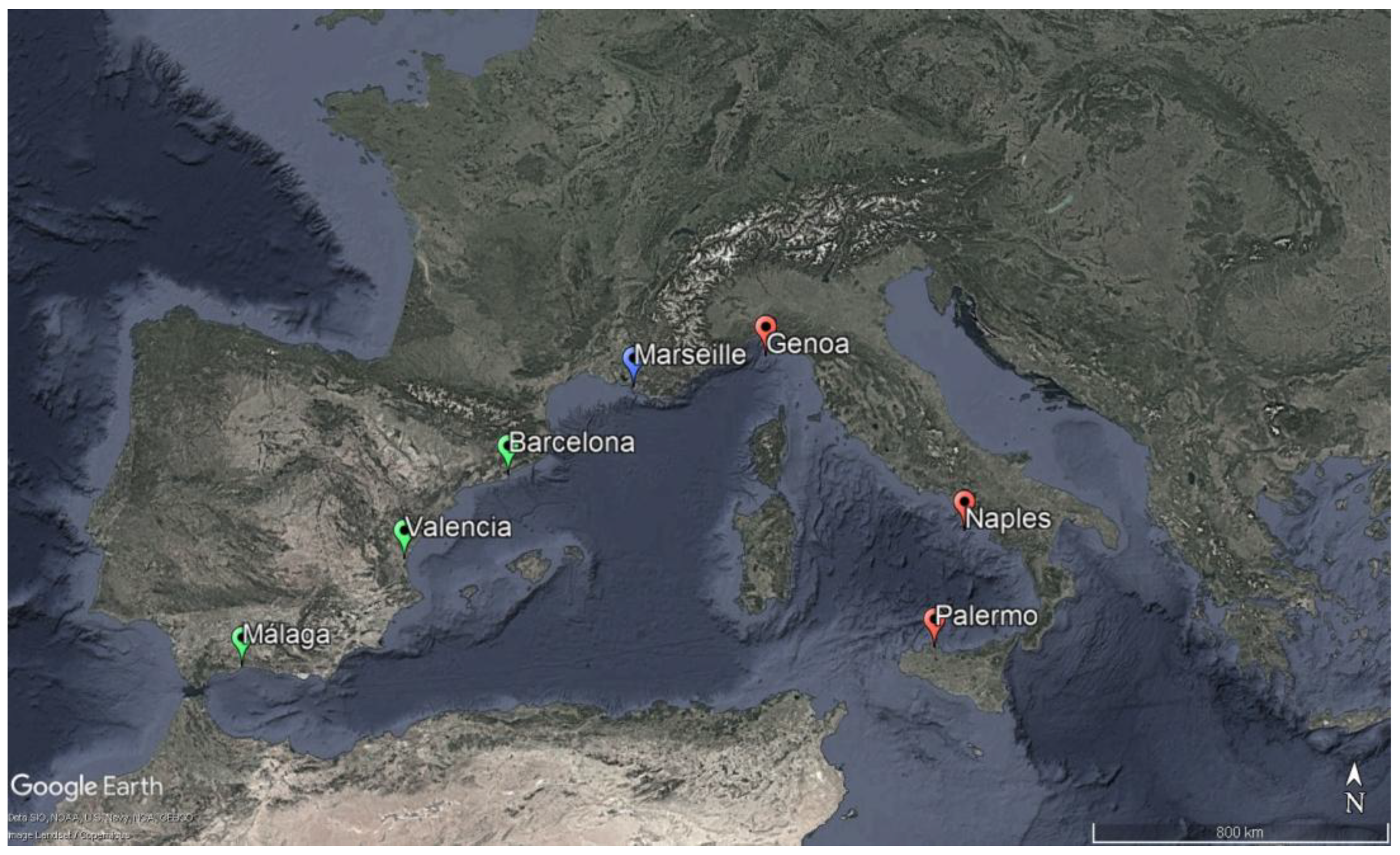
Figure 2.
(a) On the left, the freely accessible panoramic terrace of Les Terrasses du Port merely visually connects users with the sea, on the background the Euroméditerranée; (b) on the right, The area linking the Euromediterranée and the port shows a fracture between the new district and the sea which is physically and visually unreachable (pictures by I. Pistone, 2021).
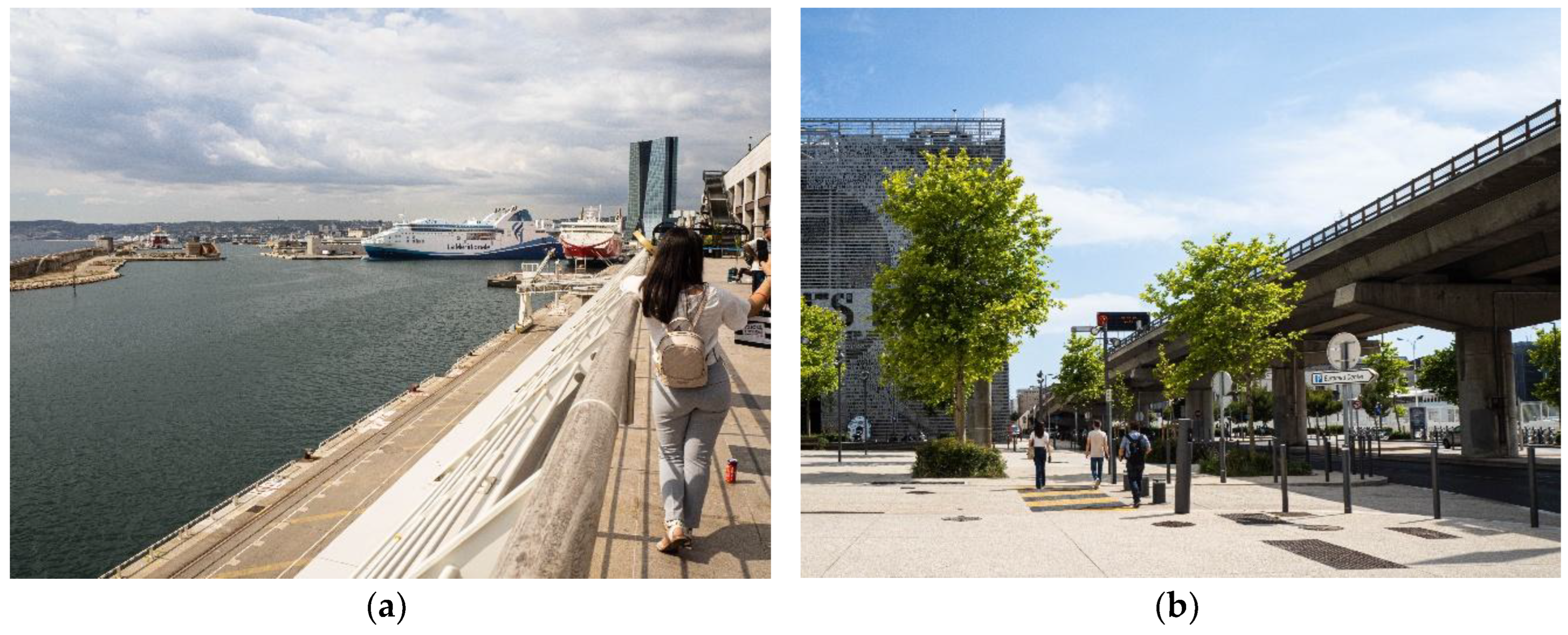
Figure 3.
(a) Plage des Catalans is perfectly set in the urban environment: (a) on the left, the arcade hosted fee-based services, now closed; (b) on the right, the beach volleyball court, marked out by the fence, and the Tour Lazaret, from which a sea promenade starts (pictures by I. Pistone, 2021).
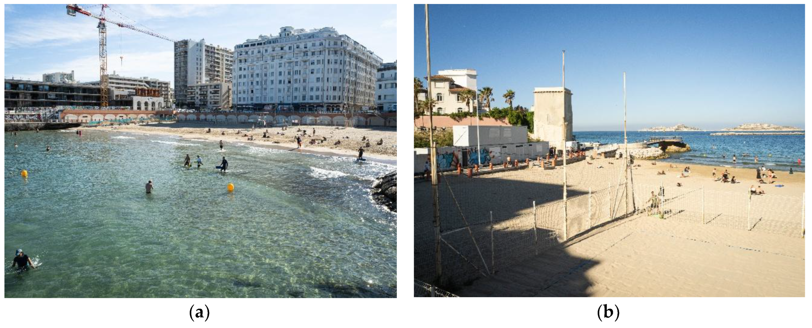
Figure 4.
(a) on the left, the coastal promenade of Passeig Maritim has the dual function of facilitating the use of the city-sea interface and connecting the Barceloneta shore to the city; (b) on the right, Barceloneta beach from above (from Wikimedia Commons, licensed under CC BY 2.0).
Figure 4.
(a) on the left, the coastal promenade of Passeig Maritim has the dual function of facilitating the use of the city-sea interface and connecting the Barceloneta shore to the city; (b) on the right, Barceloneta beach from above (from Wikimedia Commons, licensed under CC BY 2.0).
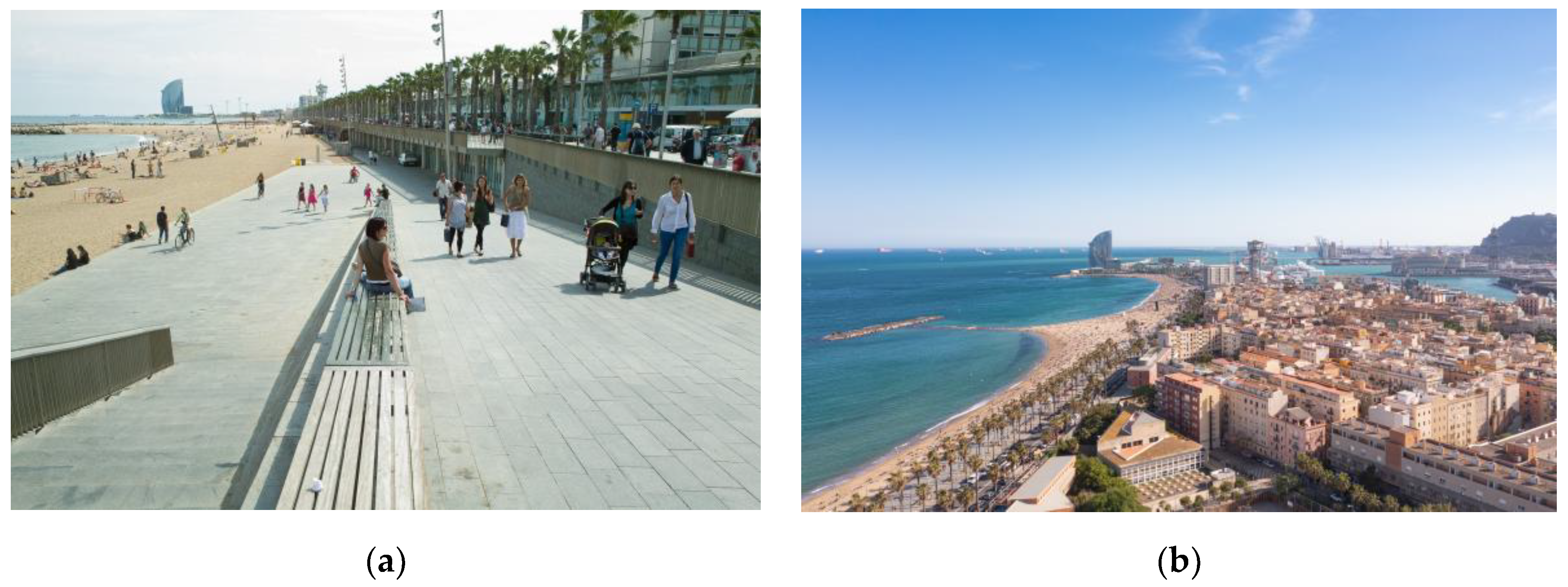
Figure 5.
The urban complex of Diagonal Mar i el Front Marítim del Poblenou takes on the features of a major transformation project linked to a great event, even without fully integrating itself on a functional level into the city system (from Wikimedia Commons, licensed under CC BY 3.0).
Figure 5.
The urban complex of Diagonal Mar i el Front Marítim del Poblenou takes on the features of a major transformation project linked to a great event, even without fully integrating itself on a functional level into the city system (from Wikimedia Commons, licensed under CC BY 3.0).
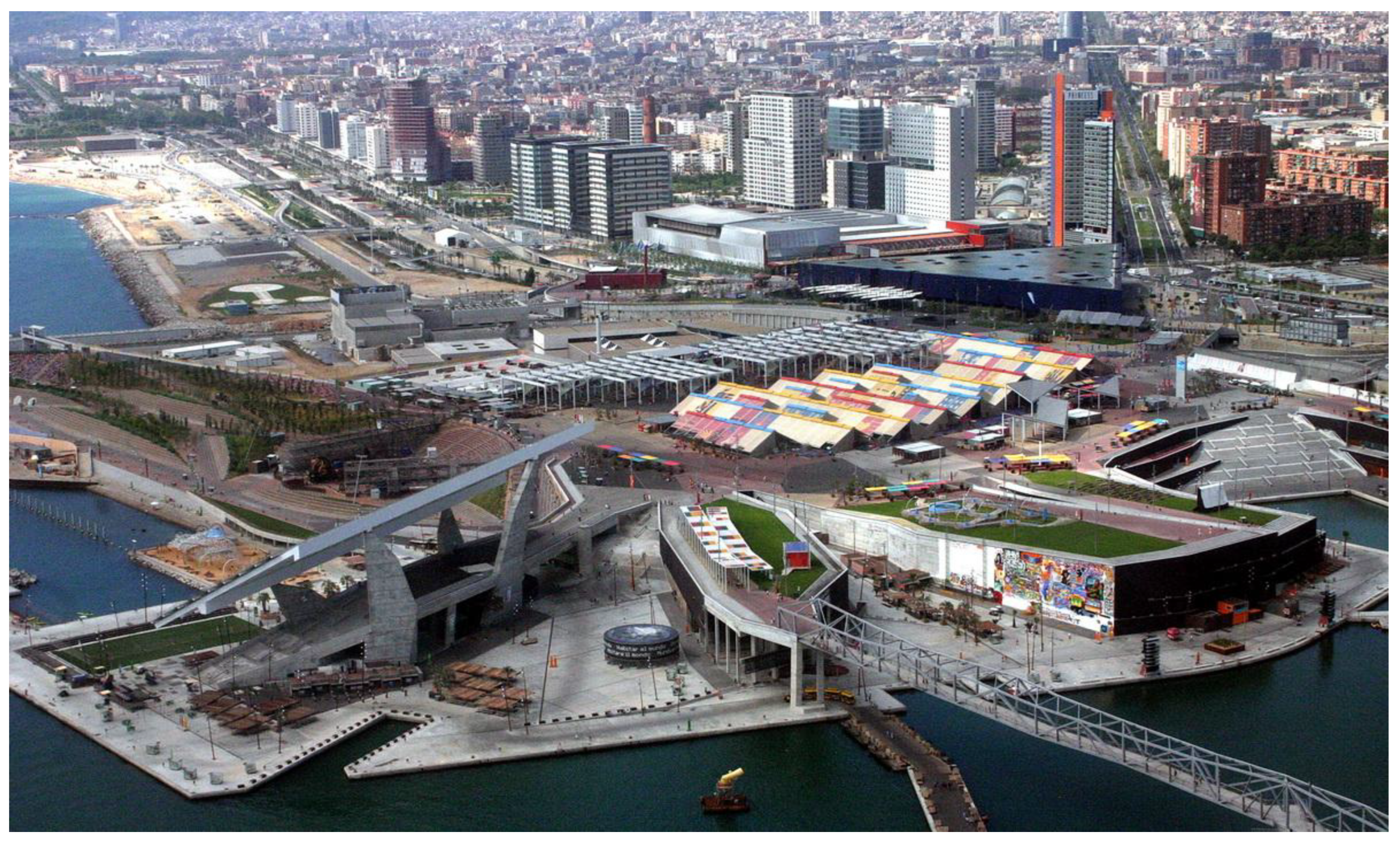
Figure 6.
The Marina Real Juan Carlos I follows the Valencian coastal profile, offering the possibility for users to get in touch with the sea resource (source: www.comunitatvalenciana.com).
Figure 6.
The Marina Real Juan Carlos I follows the Valencian coastal profile, offering the possibility for users to get in touch with the sea resource (source: www.comunitatvalenciana.com).

Figure 7.
The Palmeral de las Sorpresas, designed by the archistar Santiago Calatrava, defines the pedestrian space along the coast of Málaga, bordering both the sea and the adjacent urban green area of the Parque de Málaga (on the left) (source: https://arquitecturaviva.com/).
Figure 7.
The Palmeral de las Sorpresas, designed by the archistar Santiago Calatrava, defines the pedestrian space along the coast of Málaga, bordering both the sea and the adjacent urban green area of the Parque de Málaga (on the left) (source: https://arquitecturaviva.com/).
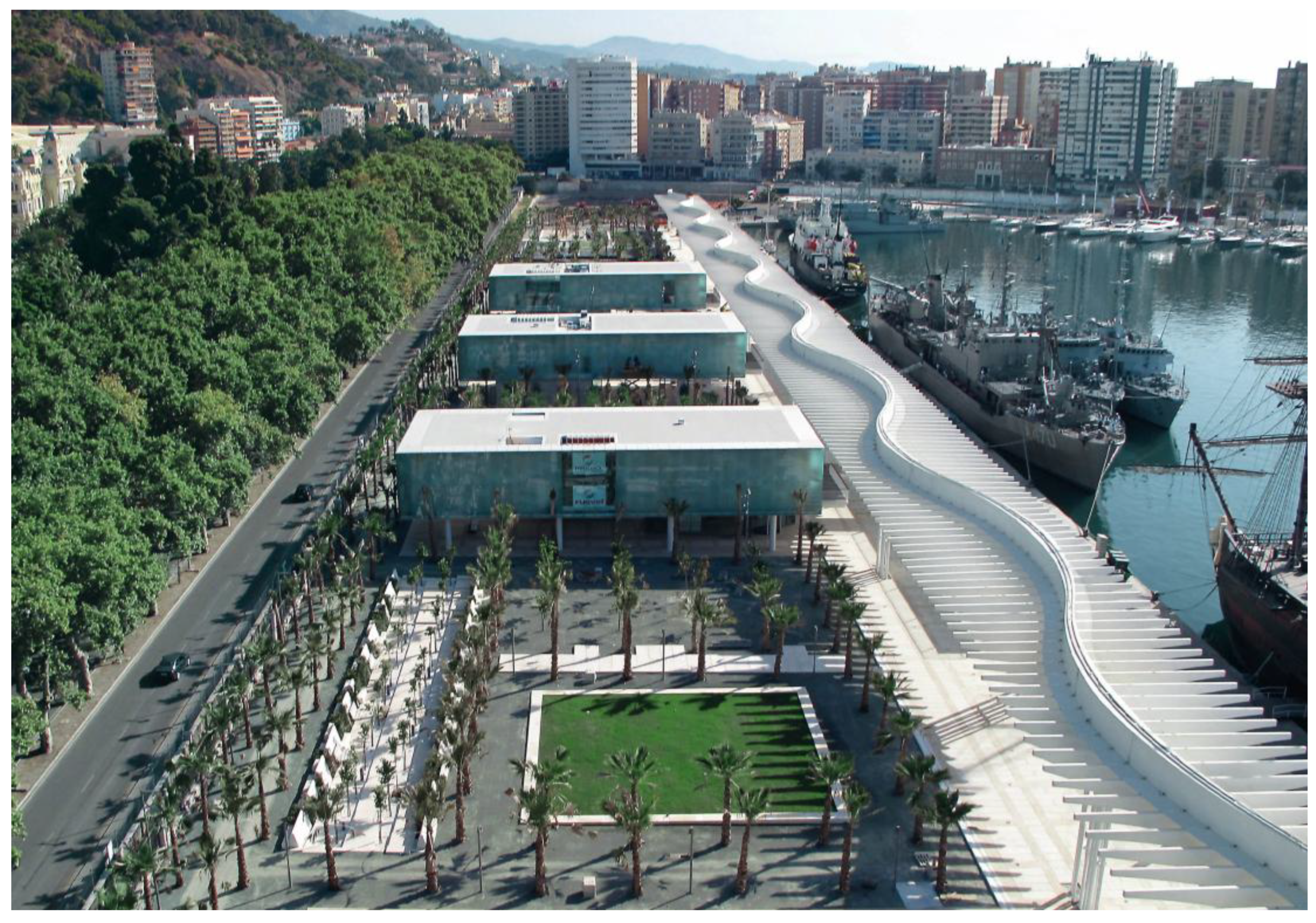
Figure 8.
One of the new public spaces envisaged for the filtering line between the port infrastructure and the urban area along the coastal interface of Naples, proposing a juxtaposition between logistic and social uses of the coast (source: https://napoli.repubblica.it/).
Figure 8.
One of the new public spaces envisaged for the filtering line between the port infrastructure and the urban area along the coastal interface of Naples, proposing a juxtaposition between logistic and social uses of the coast (source: https://napoli.repubblica.it/).
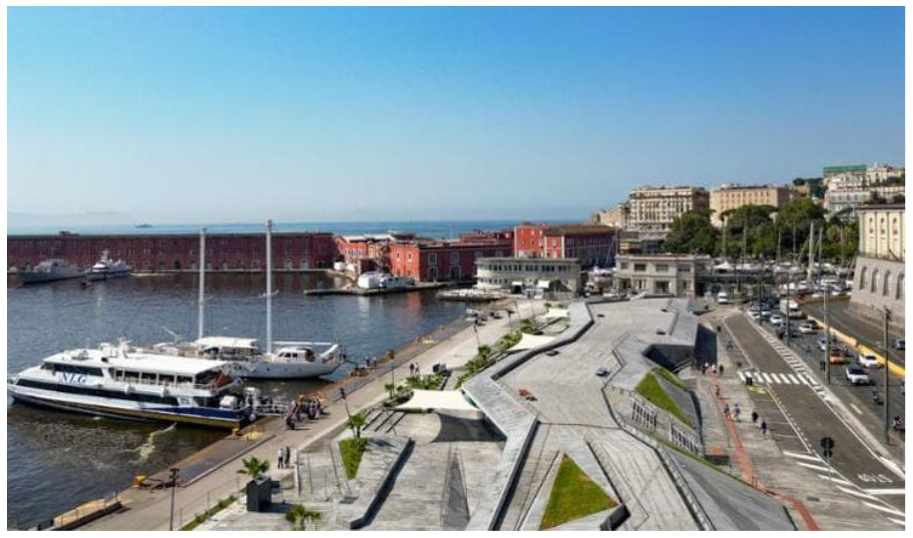
Figure 9.
Aerial view of the winning project of the call the transformation of the former productive area. There is an intention to create a vast urban park and to work on the contact with the sea, sacrificing the local scale of intervention (source: https://www.invitalia.it/).
Figure 9.
Aerial view of the winning project of the call the transformation of the former productive area. There is an intention to create a vast urban park and to work on the contact with the sea, sacrificing the local scale of intervention (source: https://www.invitalia.it/).
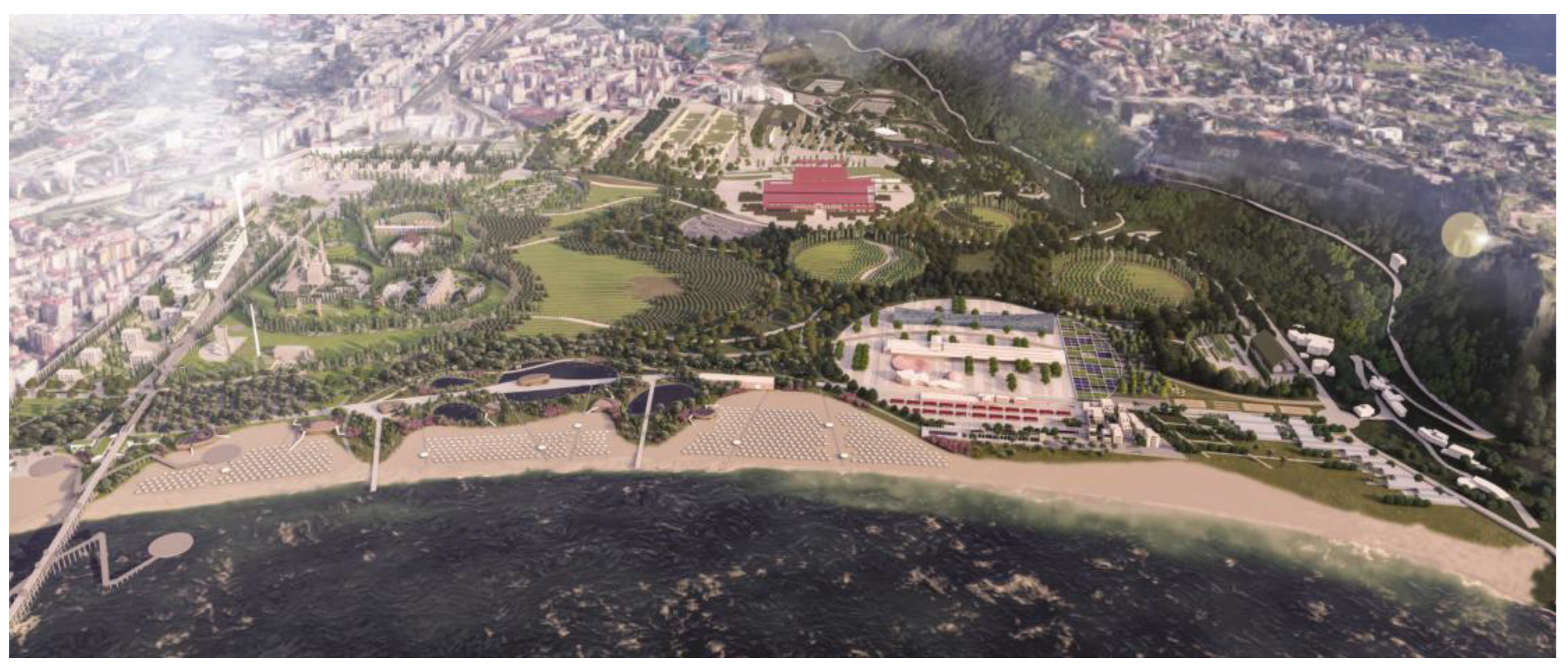
Figure 10.
Masterplan of the port of Palermo, identifying areas for sport and leisure activities (in purple and light blue), an area with high landscape-ecological value (in green) and an area dedicated to the specific connection between city and sea (in grey) (source: www.adsppalermo.it).
Figure 10.
Masterplan of the port of Palermo, identifying areas for sport and leisure activities (in purple and light blue), an area with high landscape-ecological value (in green) and an area dedicated to the specific connection between city and sea (in grey) (source: www.adsppalermo.it).
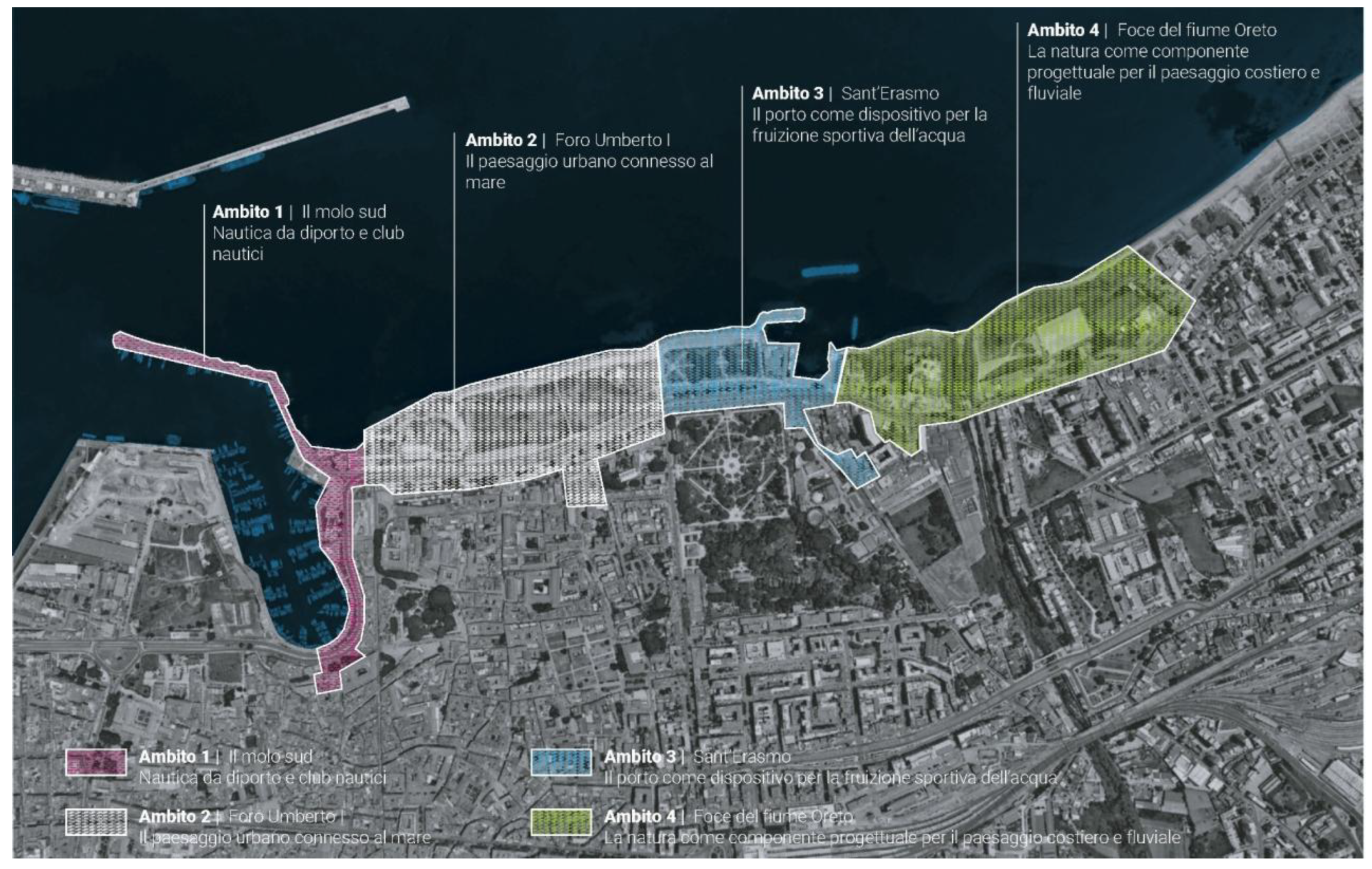
Figure 11.
The operations on the Porto Antico in Genoa have remodeled the harbour area of the city-sea interface through the creation of public spaces and some landmark buildings. (from Wikimedia Commons, licensed under CC BY-SA 3.0, author: A. Sbarbaro).
Figure 11.
The operations on the Porto Antico in Genoa have remodeled the harbour area of the city-sea interface through the creation of public spaces and some landmark buildings. (from Wikimedia Commons, licensed under CC BY-SA 3.0, author: A. Sbarbaro).
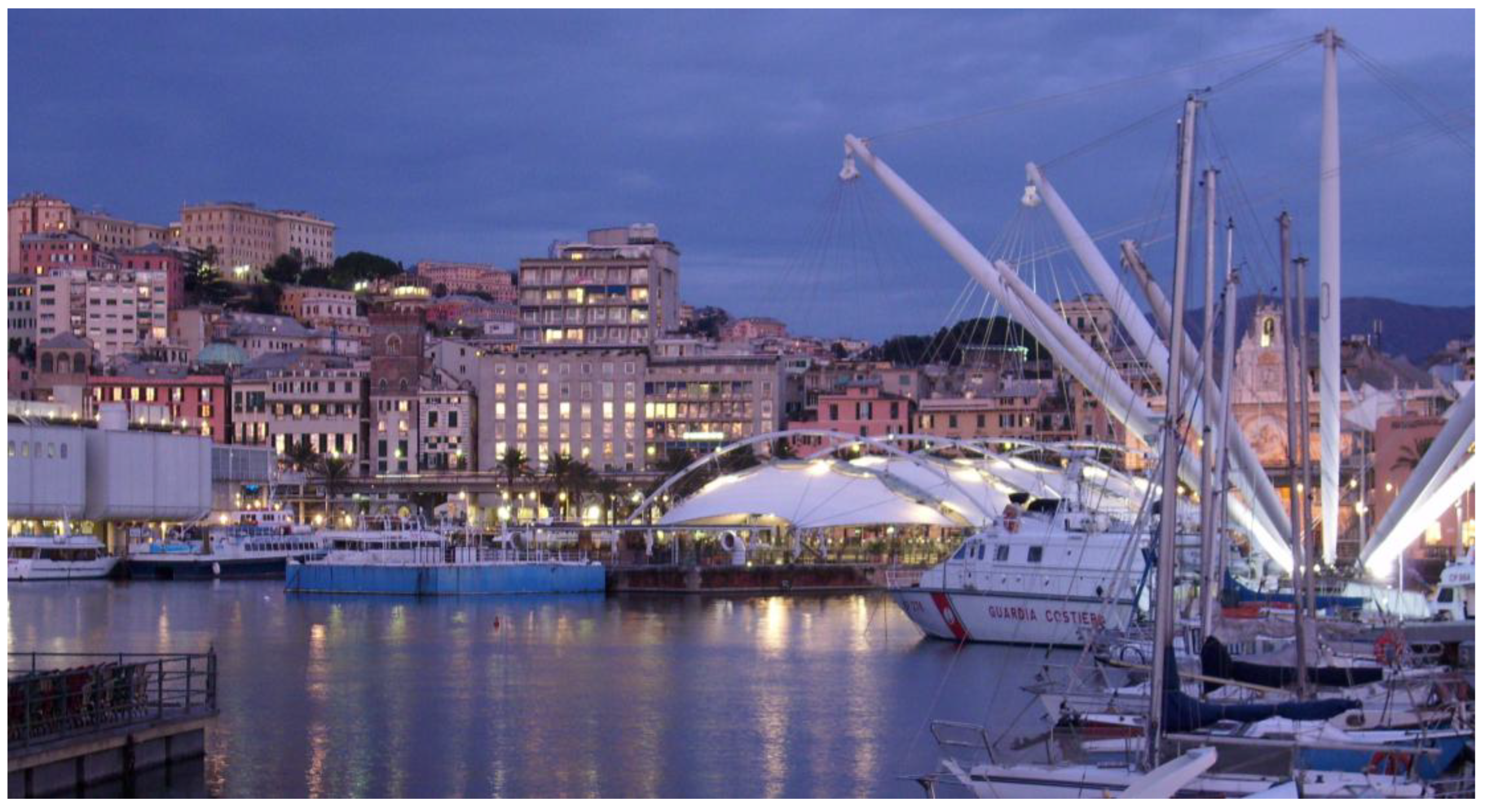
Figure 12.
The Parco delle Dune of Genoa-Prà and its walkway fits into the urban context as an environmental filter between the port and the sea (source: https://www.portsofgenoa.com/).
Figure 12.
The Parco delle Dune of Genoa-Prà and its walkway fits into the urban context as an environmental filter between the port and the sea (source: https://www.portsofgenoa.com/).
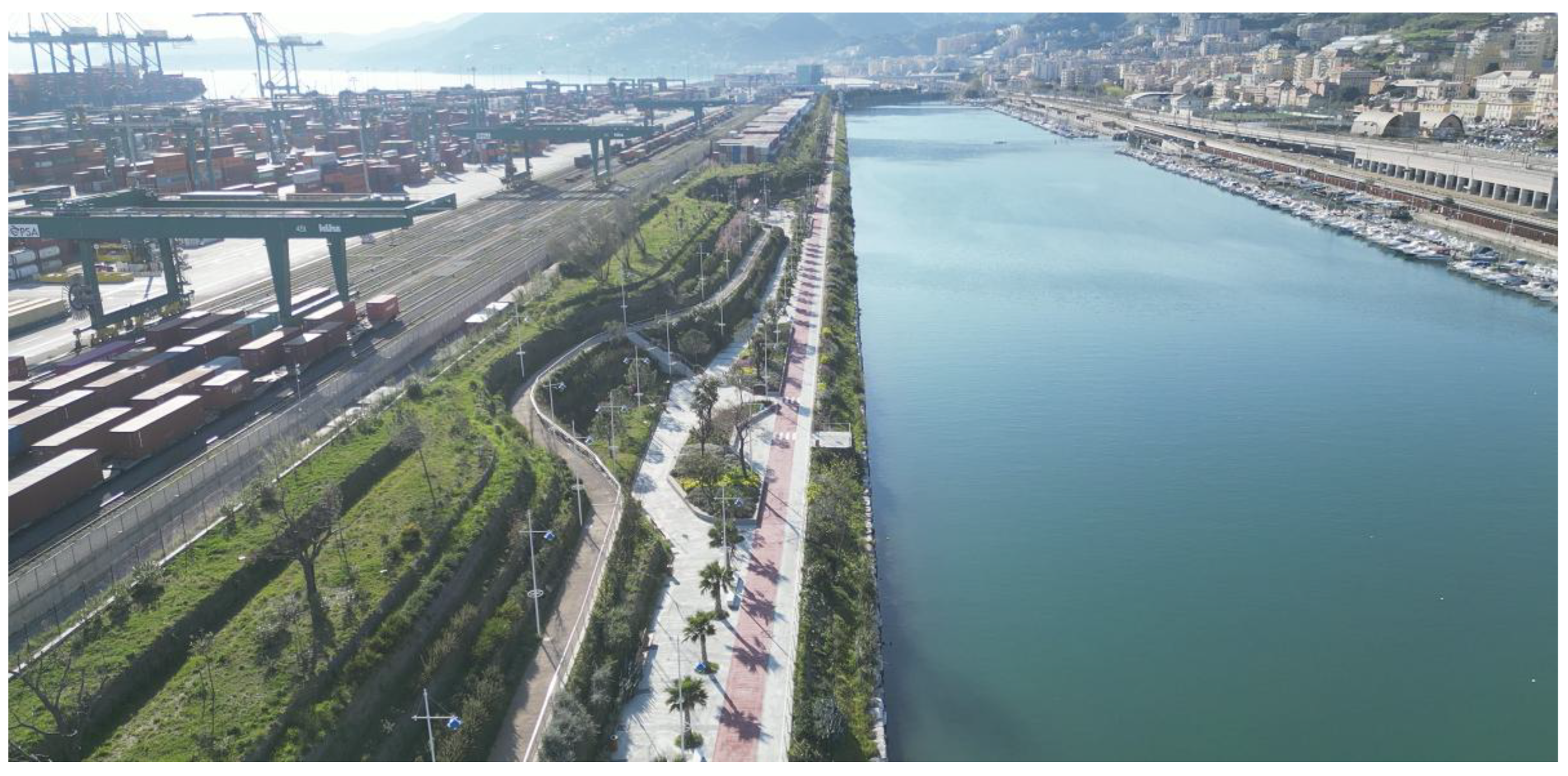
Figure 13.
Radar chart showing the normalized average values for five key indicators across the four identified urban clusters (elaboration of I. Pistone).
Figure 13.
Radar chart showing the normalized average values for five key indicators across the four identified urban clusters (elaboration of I. Pistone).
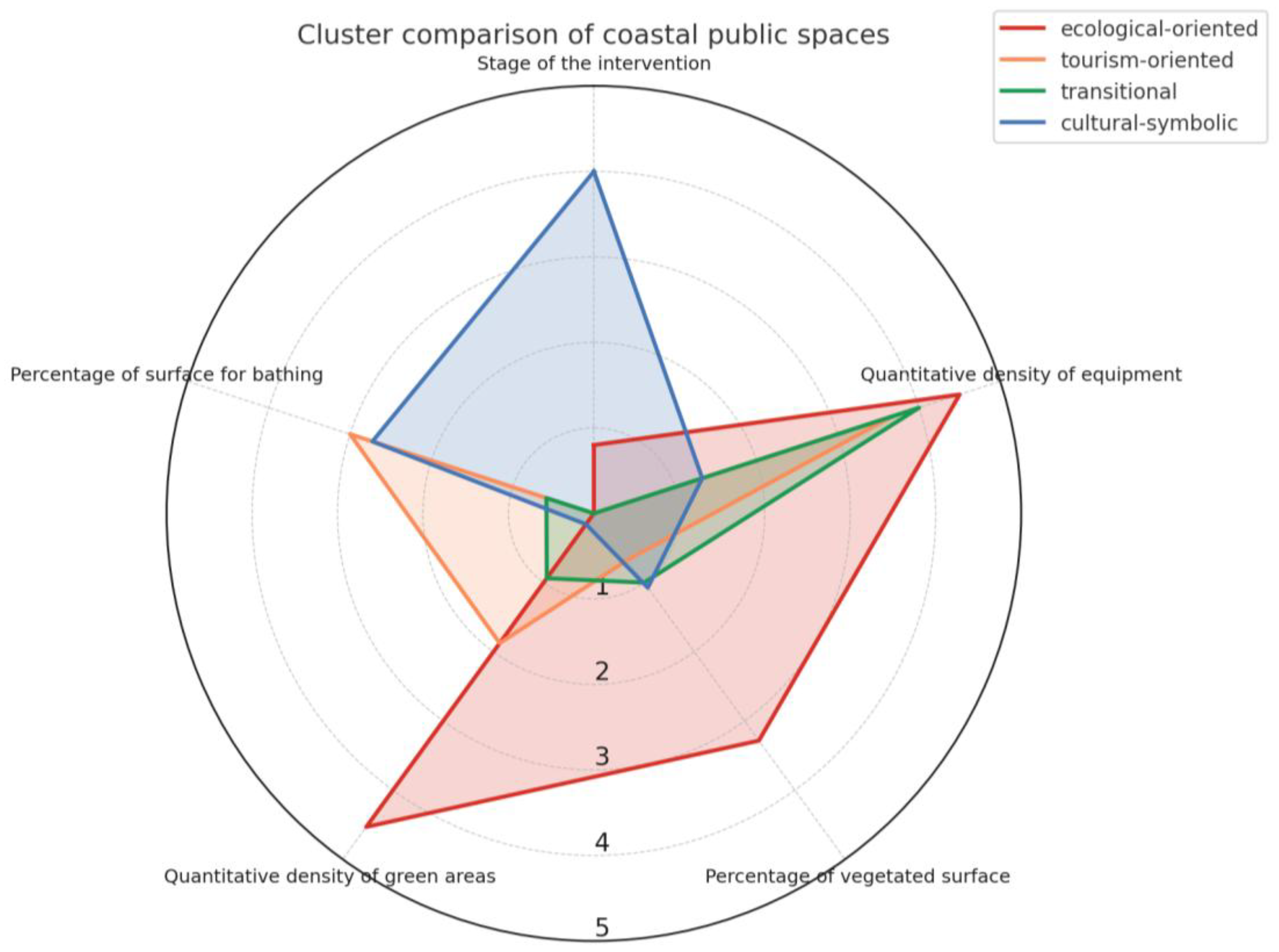
Table 1.
Distribution of Euro-Mediterranean coastal cities by population size and EU Member State. This table shows the number of EU maritime municipalities bordering the Mediterranean Sea, classified into four population categories and disaggregated by country (elaboration of I. Pistone).
Table 1.
Distribution of Euro-Mediterranean coastal cities by population size and EU Member State. This table shows the number of EU maritime municipalities bordering the Mediterranean Sea, classified into four population categories and disaggregated by country (elaboration of I. Pistone).
| France | Spain | Italy | Slovenia | Croatia | Greece | Cyprus | Malta | |
|---|---|---|---|---|---|---|---|---|
| Minor cities < 50k inhab. |
6 | 7 | 27 | 0 | 2 | 5 | 1 | 2 |
| Medium cities 50k-200k inhab. |
8 | 23 | 33 | 1 | 4 | 12 | 2 | 0 |
| Large cities 200k-500k inhab. |
1 | 3 | 4 | 0 | 0 | 1 | 0 | 0 |
| Major cities >500k inhab. |
1 | 3 | 3 | 0 | 0 | 0 | 0 | 0 |
| Total | 16 | 36 | 67 | 1 | 6 | 18 | 3 | 2 |
Table 2.
Distribution of major port functions across Euro-Mediterranean coastal cities. The table presents the number of cities hosting ports with various functions, divided by country, revealing the widespread presence of leisure harbours in the Mediterranean basin (elaboration of I. Pistone).
Table 2.
Distribution of major port functions across Euro-Mediterranean coastal cities. The table presents the number of cities hosting ports with various functions, divided by country, revealing the widespread presence of leisure harbours in the Mediterranean basin (elaboration of I. Pistone).
| France | Spain | Italy | Slovenia | Croatia | Greece | Cyprus | Malta | |
|---|---|---|---|---|---|---|---|---|
| Logistic and productive ports | 7 | 10 | 19 | 1 | 2 | 6 | 1 | 0 |
| Commercial ports | 7 | 17 | 32 | 1 | 5 | 12 | 3 | 0 |
| Tourist ports | 7 | 15 | 26 | 1 | 6 | 18 | 3 | 2 |
| Leisure ports | 16 | 36 | 67 | 1 | 6 | 18 | 3 | 2 |
| Total | 37 | 78 | 144 | 4 | 19 | 54 | 10 | 4 |
Table 3.
Presence of the four port categories by population size of coastal cities. This table analyses the distribution of the four main port functions in relation to the population size of coastal municipalities. (elaboration of I. Pistone).
Table 3.
Presence of the four port categories by population size of coastal cities. This table analyses the distribution of the four main port functions in relation to the population size of coastal municipalities. (elaboration of I. Pistone).
| Logistic-productive | Commercial | Tourist | Leisure | |
|---|---|---|---|---|
| Minor cities < 50k inhab. |
7 | 17 | 18 | 50 |
| Medium cities 50k-200k inhab. |
27 | 45 | 44 | 83 |
| Large cities 200k-500k inhab. |
5 | 8 | 9 | 9 |
| Major cities >500k inhab. |
7 | 7 | 7 | 7 |
| Total | 46 | 77 | 78 | 149 |
Table 4.
The CITI4SEA evaluation grid used in this study to assess the features of coastal public spaces (elaboration of I. Pistone).
Table 4.
The CITI4SEA evaluation grid used in this study to assess the features of coastal public spaces (elaboration of I. Pistone).
| Objective | Criteria | Indicators | Expected response |
|---|---|---|---|
| Quantify the physical extent of the analyzed area to enable spatial comparisons between case studies with respect to various parameters | Geographical extent | Total surface of the study site | value in m2 |
| Classify coastal public space according to its predominant uses, considering established or emerging functions, for typological and functional comparisons between different areas. | Typology of uses | Functional classification |
Only one choice ☐ Park ☐ Beach ☐ Promenade ☐ Waterfront square ☐ Marina ☐ Harbour ☐ Other (specify) |
| Prevalent use categories |
Multiple choices available ☐ Recreational ☐ Cultural ☐ Bathing ☐ Exhibition ☐ Sports ☐ Commercial ☐ Port ☐ Other (specify) |
||
| Determine the stage of implementation of the project and its timeframe in order to relate it to other urban processes or transformation dynamics | Period and stage of implementation | Stage of the intervention |
Only one choice ☐ Realised ☐ Ongoing ☐ Not realised |
| Time frame for realisation | Time range or decade, if applicable | ||
| Map the presence and assess the functional diversity of facilities for public fruition, with the aim of comparing the accessibility degree to different uses of coastal public space | Equipment provision | Types of equipment found in the study area |
Multiple choices available ☐ Urban furniture (benches, playgrounds, bins…) ☐ Sanitary services (toilets, showers, changing rooms…) ☐ Sports facilities (open courts, outdoor gyms…) ☐ Refreshment points (kiosks, bars, restaurants...) ☐ Cultural and recreational hubs (museums, open-air cinemas…) ☐ Other (specify) |
| Quantitative density of equipment | Sum of selected types of equipment, each worth 1 point (Range 0–5) | ||
| Evaluate the ecological and landscape quality of space through the surface and complexity of vegetated areas, in terms of environmental resilience and climate comfort. | Green areas | Percentage of vegetated surface | % (value in m2) |
| Structure of green areas |
Multiple choices available ☐ Rows of trees, isolated plants ☐ Low-growing vegetation (e.g. lawn) ☐ Shrub vegetation (bushes, hedges...) ☐ Tree vegetation (e.g. groups of trees, urban woods) |
||
| Quantitative density of green areas | Sum of selected types of green areas, each worth 1 point (Range 0–3) | ||
| Assess the functional importance of bathing in relation to the entire area and identify the physical features that allow access and direct enjoyment of the sea. | Bathing areas | Percentage of surface for bathing | % (value in m2) |
| Types of bathing area |
Multiple choices available ☐ Natural beach ☐ Artificial platform ☐ Mixed |
Table 5.
The CITI4SEA analysis shows the diversity of Marseille’s coastal public spaces, combining large-scale park infrastructures with more localised interventions for bathing and social contact with the sea (elaboration of I. Pistone).
Table 5.
The CITI4SEA analysis shows the diversity of Marseille’s coastal public spaces, combining large-scale park infrastructures with more localised interventions for bathing and social contact with the sea (elaboration of I. Pistone).
| Marseille city-sea interface | |||||
|---|---|---|---|---|---|
| Geographical extent | |||||
| Total surface of the study site | Prado | Pointe Rouge | Euromed J4 pier | Catalans | Corbière |
| 400,000 m2 | 172,000 m2 | 43,500 m2 | 12,400 m2 | 22,000 m2 | |
| Typology of uses | |||||
| Functional classification | Prado | Pointe Rouge | Euromed J4 pier | Catalans | Corbière |
| Park | Marina | Square | Beach | Beach | |
| Prevalent use categories | Recreational, bathing, sports, commercial | Port, bathing, recreational | Recreational, cultural, bathing, exhibition | Bathing, sports, cultural | Bathing, sports, recreational, cultural |
| Period and stage of implementation | |||||
| Stage of the intervention | Prado | Pointe Rouge | Euromed J4 pier | Catalans | Corbière |
| Realised | Realised | Realised | Ongoing | Realised | |
| Time frame for realisation | 1970s | 2016-2020 | 2009-2013 | Started in 2020 | mid 1970s-1987 |
| Equipment provision | |||||
| Types of equipment found in the study area | Prado | Pointe Rouge | Euromed J4 pier | Catalans | Corbière |
| Urban furniture, sports facilities, refresh. points, cultural hub |
Urban furniture, sanitary services, refresh. points | Urban furniture, refresh. points, cultural and recreational hub | Urban furniture, sanitary services, sports facilities, cultural hub | Urban furniture, sanitary services, sports facilities cultural hub |
|
| Quantitative density of equipment | 4 | 3 | 3 | 4 | 4 |
| Green areas | |||||
|
Percentage of vegetated surface |
Prado | Pointe Rouge | Euromed J4 pier | Catalans | Corbière |
| 65% (260,000 m2) | 0% | 0% | 12% (1,450 m2) | 45% (9,800 m2) | |
| Structure of green areas | Low-growing and shrub vegetation | Not detected | Rows of trees | Low-growing vegetation | Low-growing, shrub and tree vegetation |
| Quantitative density of green areas | 2 | 0 | 1 | 1 | 3 |
| Bathing areas | |||||
| Percentage of surface for bathing | Prado | Pointe Rouge | Euromed J4 pier | Catalans | Corbière |
| 25% (100,000 m2) | 6% (10,200 m2) | 0% (not allowed) | 35% (4,300 m2) | 32% (7,120 m2) | |
| Types of bathing area | Natural beach | Natural beach | Artificial platform | Natural beach | Natural beach |
Table 6.
The evaluation grid reveals how Barcelona’s waterfront has evolved through event-led planning, with multifunctional public spaces and uneven ecological integration (elaboration of I. Pistone).
Table 6.
The evaluation grid reveals how Barcelona’s waterfront has evolved through event-led planning, with multifunctional public spaces and uneven ecological integration (elaboration of I. Pistone).
| Barcelona city-sea interface | ||||
|---|---|---|---|---|
| Geographical extent | ||||
| Total surface of the study site | Barceloneta | Passeig Maritim | Diagonal Mar | Parc del Forum |
| 35,800 m2 | 97,900 m2 | 143,000 m2 | 200,000 m2 | |
| Typology of uses | ||||
| Functional classification | Barceloneta | Passeig Maritim | Diagonal Mar | Parc del Forum |
| Beach | Promenade | Park | Park | |
| Prevalent use categories | Recreational, bathing, sports | Recreational | Recreational, cultural, commercial | Recreational, cultural, exhibition, bathing, port |
| Period and stage of implementation | ||||
| Stage of the intervention | Barceloneta | Passeig Maritim | Diagonal Mar | Parc del Forum |
| Realised | Realised | Realised | Realised | |
| Time frame for realisation | 1987-1992 | 1987-1992 | 1999–2002 | 2000-2004 |
| Equipment provision | ||||
| Types of equipment found in the study area | Barceloneta | Passeig Maritim | Diagonal Mar | Parc del Forum |
| Urban furniture, sports facilities, refreshment points | Urban furniture, refreshment points | Urban furniture, cultural-recreational hubs, refresh. points | Urban furniture, refreshment points, cultural-recreational hubs |
|
| Quantitative density of equipment | 3 | 2 | 3 | 3 |
| Green areas | ||||
| Percentage of vegetated surface | Barceloneta beach | Passeig Maritim | Diagonal Mar | Parc del Forum |
| 0% | 0% | 45% (65,000 m2) | 26% (52,000 m2) | |
| Structure of green areas | Not detected | Rows of trees | Low-growing, shrub and tree vegetation | Low-growing and tree vegetation |
| Quantitative density of green areas | 0 | 1 | 3 | 2 |
| Bathing areas | ||||
| Percentage of surface for bathing | Barceloneta | Passeig Maritim | Diagonal Mar | Parc del Forum |
| 90% (32,200 m2) | 0% | 0% | 6% (11,250 m2) | |
| Types of bathing area | Natural beach | Not detected | Not detected | Artificial platform |
Table 7.
The CITI4SEA assessment highlights two contrasting trajectories in Valencia’s coastal development: a top-down marina regeneration and a grassroots-driven waterfront renewal (elaboration of I. Pistone).
Table 7.
The CITI4SEA assessment highlights two contrasting trajectories in Valencia’s coastal development: a top-down marina regeneration and a grassroots-driven waterfront renewal (elaboration of I. Pistone).
| Valencia city-sea interface | ||
|---|---|---|
| Geographical extent | ||
| Total surface of the study site | Marina Real Juan Carlos I | El Cabanyal waterfront |
| 237,000 m2 | 1,432,000 m2 | |
| Typology of uses | ||
| Functional classification | Marina Real Juan Carlos I | El Cabanyal waterfront |
| Marina | Coastal neighbourhood | |
| Prevalent use categories | Recreational, cultural, exhibition, port | Residential, commercial, recreational, cultural, bathing |
| Period and stage of implementation | ||
| Stage of the intervention | Marina Real Juan Carlos I | El Cabanyal waterfront |
| Realised | Ongoing | |
| Time frame for realisation | 2000s | Started in 2023 |
| Equipment provision | ||
| Types of equipment found in the study area | Marina Real Juan Carlos I | El Cabanyal waterfront |
| Urban furniture, refreshment points, cultural-recreational hubs, sports facilities |
Urban furniture, refreshment points, cultural-recreational hubs, sports facilities |
|
| Quantitative density of equipment | 4 | 4 |
| Green areas | ||
| Percentage of vegetated surface | Marina Real Juan Carlos I | El Cabanyal waterfront |
| 9% (21,700 m2) | 13% (191,000 m2) | |
| Structure of green areas | Low-growing and tree vegetation | Low-growing and tree vegetation |
| Quantitative density of green areas | 2 | 2 |
| Bathing areas | ||
| Percentage of surface for bathing | Marina Real Juan Carlos I | El Cabanyal waterfront |
| 0% | 16% (233,000 m2) | |
| Types of bathing area | Not detected | Natural beach |
Table 8.
The assessment identifies a spatial gradient in Málaga’s city–sea interface, from decentralised beach-based leisure zones to central green-cultural spaces (elaboration of I. Pistone).
Table 8.
The assessment identifies a spatial gradient in Málaga’s city–sea interface, from decentralised beach-based leisure zones to central green-cultural spaces (elaboration of I. Pistone).
| Málaga city-sea interface | ||||
|---|---|---|---|---|
| Geographical extent | ||||
| Total surface of the study site | Pedralejo beach | Baños del Carmen | Palmeral Sorpresas | Parque de Málaga |
| 24,000 m2 | 4,600 m2 | 26,700 m2 | 38,500 m2 | |
| Typology of uses | ||||
| Functional classification | Pedralejo beach | Baños del Carmen | Palmeral Sorpresas | Parque de Málaga |
| Beach | Beach | Square | Park | |
| Prevalent use categories | Bathing, cultural recreational | Bathing, cultural recreational | Port, recreational, cultural, exhibition, | Recreational, cultural |
| Period and stage of implementation | ||||
| Stage of the intervention | Pedralejo beach | Baños del Carmen | Palmeral Sorpresas | Parque de Málaga |
| Ongoing | Ongoing | Realised | Realized | |
| Time frame for realisation | 2010-2025 (expected renovation) | Started renovation in 2025 | 2002-2011 | Renovation in 2007 (originally 1897-1921) |
| Equipment provision | ||||
| Types of equipment found in the study area | Pedralejo beach | Baños del Carmen | Palmeral Sorpresas | Parque de Málaga |
| Urban furniture, sanitary services, refreshment points, cultural-recreational hub | Urban furniture, sanitary services, sports facilities, refreshment points, cultural hub | Urban furniture, refreshment points, cultural and recreational hub | Urban furniture, refreshment points, cultural and recreational hub | |
| Quantitative density of equipment | 4 | 5 | 3 | 3 |
| Green areas | ||||
| Percentage of vegetated surface | Pedralejo beach | Baños del Carmen | Palmeral Sorpresas | Parque de Málaga |
| 0% | 9% (410 m2) | 11% (3000 m2) | 90% (35,000 m2) | |
| Structure of green areas | Isolated trees | Tree vegetation | Rows of trees, low-growing and shrub vegetation | Low-growing, shrub and tree vegetation |
| Quantitative density of green areas | 1 | 1 | 3 | 3 |
| Bathing areas | ||||
| Percentage of surface for bathing | Pedralejo beach | Baños del Carmen | Palmeral Sorpresas | Parque de Málaga |
| 100% (24,000 m2) | 60% (2,750 m2) | 0% | 0% | |
| Types of bathing area | Natural beach | Natural beach | Not detected | Not detected |
Table 9.
Naples’ coast appears to be fragmented and unevenly developed, combining realised central interventions with stalled regeneration efforts (elaboration of I. Pistone).
Table 9.
Naples’ coast appears to be fragmented and unevenly developed, combining realised central interventions with stalled regeneration efforts (elaboration of I. Pistone).
| Naples city-sea interface | |||
|---|---|---|---|
| Geographical extent | |||
| Total surface of the study site | Molo Beverello | Piazza Municipio | Bagnoli regeneration |
| 2,400 m2 | 32,000 m2 | 240 ha | |
| Typology of uses | |||
| Functional classification | Molo Beverello | Piazza Municipio | Bagnoli regeneration |
| Marina | Square | Park | |
| Prevalent use categories | Port, recreational | Recreational, cultural, exhibition, commercial | Recreational, cultural, commercial, exhibition, port, bathing |
| Period and stage of implementation | |||
| Stage of the intervention | Molo Beverello | Piazza Municipio | Bagnoli regeneration |
| Realised | Realised | Not realised | |
| Time frame for realisation | 2018-2025 | 2011-2021 | Master plan defined in 2021 |
| Equipment provision | |||
| Types of equipment found in the study area | Molo Beverello | Piazza Municipio | Bagnoli regeneration |
| Urban furniture, sanitary services, refreshment points | Urban furniture, sanitary services, cultural and recreational hubs, refreshment points | Urban furniture, sanitary services, sports facilities, cultural and recreational hubs, refreshment points | |
| Quantitative density of equipment | 3 | 4 | 5 |
| Green areas | |||
| Percentage of vegetated surface | Molo Beverello | Piazza Municipio | Bagnoli regeneration |
| 10% (250 m2) | 0% | 60% (168 ha) | |
| Structure of green areas | Isolated plants, low-growing vegetation | Rows of trees | Low-growing, shrub and tree vegetation |
| Quantitative density of green areas | 2 | 0 | 3 |
| Bathing areas | |||
| Percentage of surface for bathing | Molo Beverello | Piazza Municipio | Bagnoli regeneration |
| 0% | 0% | 14% (33 ha) | |
| Types of bathing area | Not detected | Not detected | Mixed (not yet realized) |
Table 10.
The analysis highlights different degrees of functional permeability and equipment provisions in Palermo’s waterfront (elaboration of I. Pistone).
Table 10.
The analysis highlights different degrees of functional permeability and equipment provisions in Palermo’s waterfront (elaboration of I. Pistone).
| Palermo city-sea interface | ||
|---|---|---|
| Geographical extent | ||
| Total surface of the study site | Palermo port waterfront | Foro Italico Umberto I |
| 535,000 m2 | 40,000 m2 | |
| Typology of uses | ||
| Functional classification | Palermo port waterfront | Foro Italico Umberto I |
| Marina | Coastal neighbourhood | |
| Prevalent use categories | Recreational, cultural, sports, commercial, port | Recreational, cultural, portbathing |
| Period and stage of implementation | ||
| Stage of the intervention | Palermo port waterfront | Foro Italico Umberto I |
| Ongoing | Realised | |
| Time frame for realisation | Started in 2018 | 1990s-2000 |
| Equipment provision | ||
| Types of equipment found in the study area | Palermo port waterfront | Foro Italico Umberto I |
| Urban furniture, sanitary services refreshment points, cultural and recreational hubs, sports facilities |
Urban furniture, sanitary services, cultural-recreational hub |
|
| Quantitative density of equipment | 5 | 3 |
| Green areas | ||
| Percentage of permeable surface | Palermo port waterfront | Foro Italico Umberto I |
| 55% (290,000 m2) | 90% (36,000 m2) | |
| Structure of green areas | Rows of trees, Low-growing, shrub and tree vegetation | Rows of trees/isolated plants, low-growing vegetation |
| Quantitative density of green areas | 4 | 2 |
| Bathing areas | ||
| Percentage of surface for bathing | Palermo port waterfront | Foro Italico Umberto I |
| 0% | 0% | |
| Types of bathing area | Not detected | Not detected |
Table 11.
The CITI4SEA assessment reflects Genoa’s evolving city–sea strategies, from historic port uses to multifunctional and ecological coastal regeneration projects (elaboration of I. Pistone).
Table 11.
The CITI4SEA assessment reflects Genoa’s evolving city–sea strategies, from historic port uses to multifunctional and ecological coastal regeneration projects (elaboration of I. Pistone).
| Genoa city-sea interface | |||
|---|---|---|---|
| Geographical extent | |||
| Total surface of the study site | Porto Antico | Levante Waterfront | Parco Dune Genoa Prà |
| 230,000 m² | 115,000 m² | 40,000 m2 | |
| Typology of uses | |||
| Functional classification | Porto Antico | Levante Waterfront | Parco Dune Genoa Prà |
| Marina (historic waterfront) | Marina | Park | |
| Prevalent use categories | Recreational, cultural, exhibition, port | Recreational, cultural, commercial, port, bathing (expected in the future) | Recreational, cultural, exhibition |
| Period and stage of implementation | |||
| Stage of the intervention | Porto Antico | Levante Waterfront | Parco Dune Genoa Prà |
| Realised | Ongoing | Realised | |
| Time frame for realisation | 1992-2001 (updates in 2017) | Started in 2020 | 2021-2025 |
| Equipment provision | |||
| Types of equipment found in the study area | Porto Antico | Levante Waterfront | Parco Dune Genoa Prà |
| Urban furniture, sanitary services, sports facilities, refreshment points, cultural and recreational hubs | Urban furniture, sanitary services, refreshment points, cultural and recreational hubs | Urban furniture, sports facilities, refreshment points, cultural and recreational hubs | |
| Quantitative density of equipment | 5 | 4 | 4 |
| Green areas | |||
| Percentage of vegetated surface | Porto Antico | Levante Waterfront | Parco Dune Genoa Prà |
| 5% (11,500 m2) | 11% (13,000 m2) | 75% (30,000 m2) | |
| Structure of green areas | Rows of trees, isolated plants; low-growing vegetation | Rows of trees, low-growing vegetation, shrub vegetation | Low-growing, shrub and tree vegetation |
| Quantitative density of green areas | 2 | 3 | 3 |
| Bathing areas | |||
| Percentage of surface for bathing | Porto Antico | Levante Waterfront | Parco Dune Genoa Prà |
| 0% | 0% | 0% | |
| Types of bathing area | Not detected | Not detected (not yet realised) | Not detected |
Table 12.
The synthesis grid recalls the main indicators used to assess and compare the case studies and their main coastal public spaces (elaboration of I. Pistone).
Table 12.
The synthesis grid recalls the main indicators used to assess and compare the case studies and their main coastal public spaces (elaboration of I. Pistone).
| Marseille | Barcelona | Valencia | Malaga | Naples | Palermo | Genoa | |
|---|---|---|---|---|---|---|---|
| State | France | Spain | Spain | Spain | Italy | Italy | Italy |
| Analysed public spaces | 5 | 4 | 2 | 4 | 3 | 2 | 3 |
| Functional classification | Beach 40% | Park 25% | Marina 50%, Coastal Neighbourhood 50% |
Beach 25% | Marina 33%, Square 33%, Park 33% | Marina 50%, Coastal Neighbourhood 50% |
Marina 66% |
| Prevalent use categories | Bathing 80% Recreational 60% | Recreational 100% Cultural 50% Bathing 50% |
Recreational 100% Cultural 100% |
Cultural 100% Recreational 75% |
Recreational 100% Cultural 66% |
Recreational 100% Cultural 100% |
Recreational 100% Cultural 100% Port 66% |
| Stage of the intervention | Realised 80% | Realised 100% | Realised 50% | Realised 50% | Realised 50% | Realised 50% | Realised 66% |
| Quantitative density of equipment | Mode 4 Median 3.6 Average 3.6 Range 3–4 |
Mode 3 Median 3.6 Average 2.8 Range 3-2 |
Mode 4 Median 4 Average 4 Range 4-4 |
Mode 3 Median 3.5 Average 3.8 Range 5-3 |
Mode amodal Median 4 Average 4 Range 5-3 |
Mode amodal Median 4 Average 4 Range 5-3 |
Mode 4 Median 4 Average 4.3 Range 5-4 |
| Percentage of vegetated surface | Mode 0% Median 12% Average 24.4% Range 65%–0% |
Mode 0% Median 13% Average 24% Range 70%–0% |
Mode amodal Median 11% Average 11% Range 13%–9% |
Mode amodal Median 10% Average 27.5% Range 90%–0% |
Mode 0% Median 10% Average 23.3% Range 60%–0% |
Mode amodal Median 72.5% Average 72.5% Range 90%–55% |
Mode amodal Median 11% Average 30.3% Range 75%–5% |
| Quantitative density of green areas | Mode 1 Median 1 Average 1.4 Range 3 – 0 |
Mode amodal Median 1.5 Average 1.5 Range 3 – 0 |
Mode 2 Median 2 Average 2 Range 2 – 2 |
Mode 1, 3 Median 2 Average 2 Range 3 – 1 |
Mode amodal Median 2 Average 1.7 Range 3 – 0 |
Mode amodal Median 3 Average 3 Range 4 – 2 |
Mode 3 Median 3 Average 2.7 Range 3 – 2 |
| Percentage of surface for bathing | Mode 0% Median 25% Average 19.6% Range 35%-0% |
Mode 0% Median 3% Average 24% Range 90%-0% |
Mode amodal Median 8% Average 8% Range 16%-0% |
Mode 0% Median 30% Average 40% Range 100%-0% |
Mode 0% Median 0% Average 4.67% Range 14%-0% |
Mode 0% Median 0% Average 0% Range 0%-0% |
Mode 0% Median 0% Average 0% Range 0%-0% |
| Types of bathing area | - Natural beach 80% - Artificial platform 20% |
- Nat. beach 25% - Artif. plat. 25% - Not detected 50% |
- Natural beach 50% - Not detected 50% |
- Natural beach 50% - Not detected 50% |
- Not detected 66% - Mixed 33% |
- Not detected 100% | - Not detected 100% |
Disclaimer/Publisher’s Note: The statements, opinions and data contained in all publications are solely those of the individual author(s) and contributor(s) and not of MDPI and/or the editor(s). MDPI and/or the editor(s) disclaim responsibility for any injury to people or property resulting from any ideas, methods, instructions or products referred to in the content. |
© 2025 by the authors. Licensee MDPI, Basel, Switzerland. This article is an open access article distributed under the terms and conditions of the Creative Commons Attribution (CC BY) license (http://creativecommons.org/licenses/by/4.0/).
Copyright: This open access article is published under a Creative Commons CC BY 4.0 license, which permit the free download, distribution, and reuse, provided that the author and preprint are cited in any reuse.


