
Submitted:
02 May 2025
Posted:
06 May 2025
You are already at the latest version
Abstract
The Sierra de las Navajas is a Late Pliocene volcanic complex with a rhyolitic composition and peralkaline affinity. It is located on the northeastern edge of the Trans‐Mexican Volcanic Belt in the state of Hidalgo. Within this rocky massif lies Cerro de las Navajas, the site of the most intensively exploited archaeological obsidian deposit in Mesoamerica. Obsidian extraction in this area was carried out through open‐pit mining and a unique underground mining. The geological identity of the deposit encompasses the origin, distribution, and petrological characteristics of the obsidian from Cerro de las Navajas, determined through detailed geological mapping, petrographic study, and geochemical analysis. The results reveal the obsidian deposit’s style as well as its temporal and spatial position within the eruptive evolution of the region. The deposit originated from a local explosive eruptive mechanism associated with the partial collapse of a lava dome, forming a Block‐and‐Ash Flow Deposit (BAFD). The obsidian blocks, exploited by different cultures, correspond to the pyroclastic blocks within this deposit, which can reach up to 1 meter in diameter and are embedded in a weakly consolidated ash matrix. The BAFD was later buried by: (a) subsequent volcanic events, (b) structural adjustments of the volcanic edifice, and (c) soils derived from the erosion of other volcanic units. This obsidian deposit has been mined underground from the Early Formative period to the Colonial era by the cultures of the Central Highlands and colonized societies. Interest in the vitreous quality and the exotic nature of the obsidian lithics from the BAFD led to the development of a complex exploitation system, generationally refined by the Teotihuacan, Toltec, and Aztec states.
Keywords:
Sierra de Las Navajas
; Mesoamerica
; obsidian geo‐identity
1. Introduction
In Mexico, the cultures of the central, western, and Gulf regions of Mesoamerica developed within the Trans-Mexican Volcanic Belt (TMVB), an active volcanic province characterized by volcanic edifices, complex basins, valleys and lakes (Figure 1). These geological features have been utilized as sources of lithic material, agricultural lands, which were used for the development of central Mesoamerica cultures [1].
The most significant volcanic lithic resources in the region included basaltic, andesitic and rhyolitic rocks. Basaltic and andesitic rocks were mostly used as construction material in pyramids and ground artifacts (metates and molcajetes). The rhyolitic rocks and their vitreous facies like obsidians were exploited and utilized as artifacts, weapons, ornaments and magic religious objects. The obsidian sources are distributed throughout the TMVB, each possessing a unique geological and petrological identity. Several of these deposits show evidence of intensive pre-Hispanic exploitation. The occidental region of TMVB including Ucareo-Zinapécuaro; Otumba, Paredón and Sierra de las Navajas in the central region [2], and the Pico de Orizaba mines and Zaragoza-Oyameles in the oriental region. Other important source southward Mesoamerica including El Chayal and Ixtepeque in Guatemala.
The Sierra de las Navajas (SLN) is an important obsidian source that were exploited by Teotihuacan, Toltec and Aztec cultures and also in the first colonial Hispanic stage at XVI and XVII centuries. According to Pastrana et al. [3], SLN obsidian was extracted in various areas (El Jacal-El Sembo area, Cerro de Las Navajas including its summit Cruz del Milagro), which were exploited by open and dip extraction. All sites are considered sub-sources of the main magmatic body. Cultural extraction remains date back at least 2200 years and are attributed to central Mesoamerican cultures [4,5]. This study highlights the unique geological and petrological characteristics that promoted underground mining at Cerro de las Navajas, which were the most exploited in Mesoamerica [5].
Sierra de las Navajas (SLN) is classified as a geosite within the UNESCO Geopark of the Mining Region [6]. It is located in the northern TMVB in Mexico, in the State of Hidalgo, approximately 18 km east of Pachuca city and 50 km northwest of the ancient city of Teotihuacan (Figure 1).
The mining classification of this complex has been defined by the extraction of green-gold obsidian from pre-Hispanic times to the present century. The resource was extracted using both open-pit and underground mining methods. Its use and significance in pre-Hispanic times were directly related to economic development, military armament, ornamental objects for the social elite, magical-religious artifacts, and trade within the state organizations of central Mesoamerica [5,7].
The scientific studies for understanding the geological and archaeological phenomenon at SLN began in the early 18th by several international explorers and continues to the 19th and 20th century. The important studies of Humboldt and the mexican geologist Ezequiel Ordoñez [8] highlighted the scientific interest of the volcanological research. Geoarchaeological interest continues to the present.
Cerro de las Navajas hosts an important archaeological locality-area of the Instituto Nacional de Antropologia e Historia (INAH) under study, which preserves the most significant remains of rhyolitic volcanic complex and cultural exploitation. The site contains evidence of labor specialization in obsidian extraction, including site occupation, prehispanic geological knowledge and technical underground mining, lithic knapping, transportation and wide trade routes in Mesoamerica, illustrating the production sequence in the different stages of exploitation [4,12]. The green-gold obsidian was possibly the volcanic material with the greatest spatial and temporal distribution in America.
State policies on the control and geopolitical dominance of the “special and sacred glass” by the three main city-states of the Central Highlands (Teotihuacan, Tula, and Tenochtitlan capitals) influenced the strategic extraction of obsidian from Cerro de las Navajas. The geospatial knowledge of this deposit enabled the development of an engineering strategy control for extraction, knapping and polished technics, regulation, and commercialization of instruments and sacred artifacts like the beautiful John Dee famous mirror [1].
The social impact of exploitation and distribution of the Sierra de Las Navajas green-gold obsidian source is mainly reflected in the cultural development of multiple regions and is reflected in a prolonged sequence of exploitation across different cultures.
It should be noted that the most types of obsidian from Mesoamerica sources are black-grey-reddish colors and different vitreous qualities that were for elaborate a wide variety of artifacts. However, the special high vitreous quality and beautiful golden and green color varieties are notorious in America [X] [Y].
The goal of this study contributes to new geological and petrological data of the volcanic events that formed and shaped a complex green-gold obsidian source process in Cerro de Las Navajas that control their geo-identity.
2. Materials and Methods
The characterization of the identity of the obsidians from Cerro de las Navajas in SLN was carried out through detailed field work of survey and sampling. Geological reconnaissance and mapping of the volcanic units in the southwestern region of the Sierra were conducted at the sites Cruz de Milagro summit and Cerro de las Navajas prehispanic mines area (Figure 3). Sampling was performed considering only the occurrence of obsidian in each recognized lithological unit in the area, including outcrops and fronts in the underground prehispanic mines. The laboratory work included petrographic, mineralogical, and geochemical analysis, considering the constitution of the petrofabric [13]. Ten key obsidian samples were selected, cut, and polished at the Laboratorio de Corte y Laminado de la Universidad de Sonora to obtain a surface perpendicular to the volcanic stratification and parallel to the mineral lineation. These samples were petrographically analyzed using a Leica Microscope and then examined with a Thermo Fisher Scientific Niton FXL portable device at the Laboratorio de Cristalografía y Geoquímica de la Universidad de Sonora, using Energy Dispersive X-ray Fluorescence (EDXRF). Both the analytical measurement area of the equipment and the surfaces of the rock samples were cleaned with paper and alcohol to prevent contamination (e.g., dust, grease from handling, etc.).
The analysis was performed pointwise on a 1 cm2 sample, using the TEST ALL GEO method provided by the instrument manufacturer. The procedure followed that of Ochoa-Alcalá and Vidal-Solano [14], conducting three repetitions with a duration of 120 seconds each. The data were then evaluated following the methodology proposed by Vidal-Solano et al. [15], achieving greater reliability in the elements presented in Table 1.
Additionally, equipment was used to determine the crystalline facies of the obsidian samples to observe mineralogical variations among them. X-ray Diffraction (XRD) analyses of the samples were performed using selected obsidian fragments with the highest crystal content under a 40X objective in a petrographic microscope (Figure 2). Subsequently, the selected fractions were ground with an agate mortar. Finally, they were mounted on a Bruker Advance X-ray diffraction device for approximately 12 hours to achieve the highest definition in the analysis.
3. Results
3.1. Geology of Cerro de las Navajas
Sierra de las Navajas is a paleo-stratovolcano of rhyolitic composition with a peralkaline chemical affinity. Around 2.4 million years ago, its volcanic activity led to the formation of a Peléan-type lava dome within the volcanic edifice [16]. Structural instability of the volcano caused a gravitational collapse of its northeastern flank, triggering a massive lateral eruption similar to the Mount St. Helens event [16,17]. This activity culminated around 2.0 million years ago (Figure 3).
Figure 3.
5-meter resolution Digital Elevation Model (DEM) of Sierra de las Navajas Volcanic Complex. The red star indicates the location of the Cerro de las Navajas site, and the yellow star indicates the Cruz del Milagro site. The red dashed line shows the fault structure that marks the culmination of the volcanic eruption process. Additionally, the red arrow indicates the flow direction of the final volcanic episode.
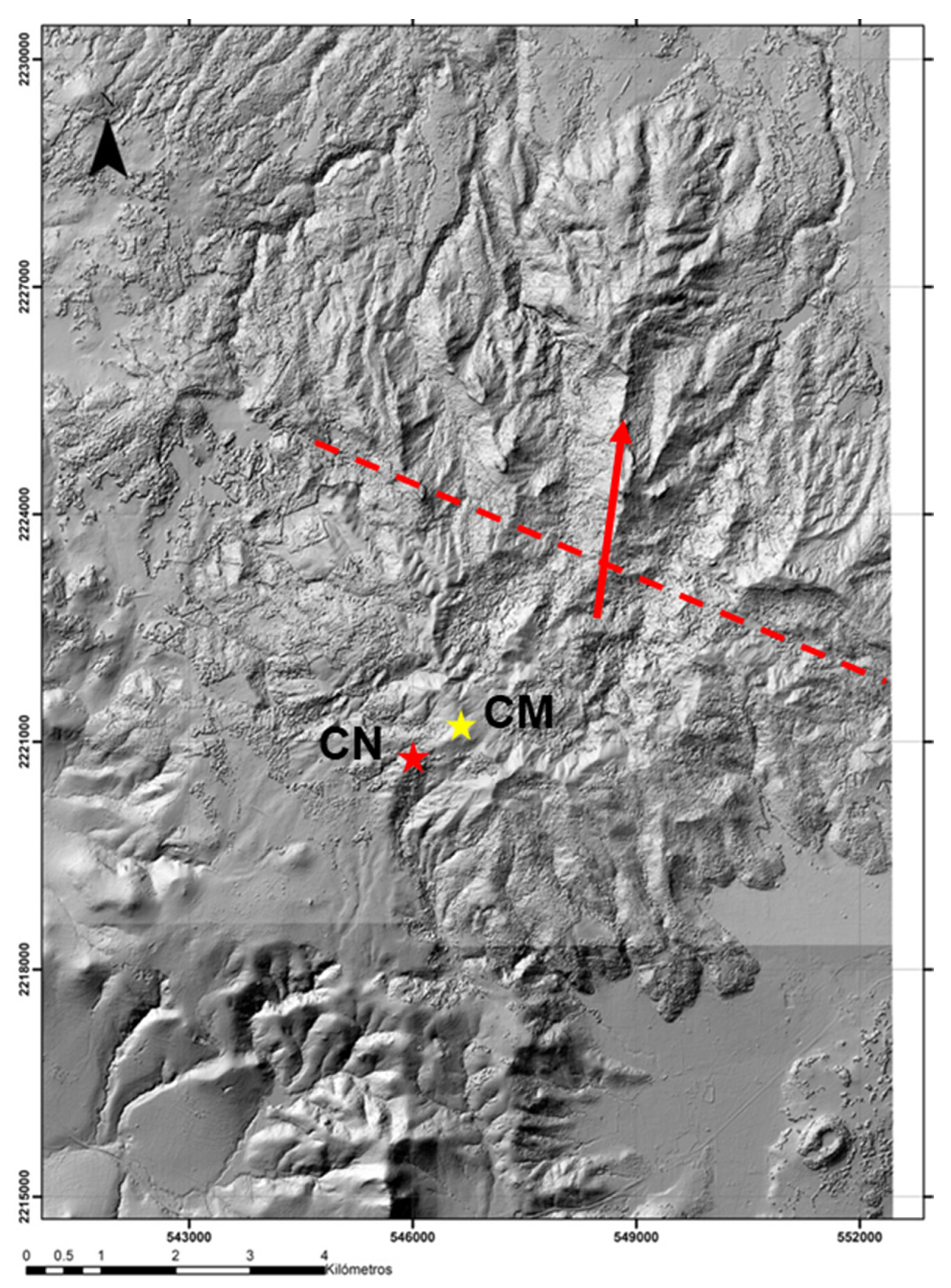
The lava dome developed dark green-gold obsidian lithofacies, appearing as bands within the lava flow [16]. It is likely that the Cerro de las Navajas and Cruz de Milagro sites, where the most intense archaeological exploitation of the SLN deposit occurred, originated from this dome and its subsequent eruptive phases.
At Cerro de las Navajas, four distinct Eruptive Events (EE) have been identified with obsidian: EE1 produced a Plinian-type pyroclastic deposit composed of lapilli tuff, containing marekanite obsidian fragments. EE2 is evidenced by the remnants of a fluidal rhyolitic dome with green obsidian bands (<5 cm thick; Figure 12). EE3 involved an explosive pulse that generated a Block and Ash Flow Deposit (BAFD), containing green-gold obsidian blocks ranging from 6 to 100 cm in length (Figure 4, Figure 5 and Figure 12). Finally, a fourth event (EE4) resulted in a Rheomorphic Ignimbrite unit with a glassy base (vitrophyre), characterized by highly fragmented black-grey obsidian blocks (<20 cm). This final event marks the end of volcanic activity at Cerro de las Navajas, sealing the previous deposits and shows a distinct undefined magma vent (Figure 4).
3.2. Petrography and X-Ray Diffraction
An obsidian petrographic characterization was carried out in samples of the logical units. The obsidian from blocks of the volcanic unit of EE3 exhibits a variation in green hues. Petrographically, these obsidians range from dark green to green-gold and are aphanitic, with scarce or no presence of phenocrysts or microphenocrysts. Notably, green-gold obsidian contains abundant fluid inclusions (<150 microns), which are angular, sometimes decrepitated, and aligned with the lava flow (Figure 6). These inclusions indicate a flow direction derived of an origin from lava for the block.
X-ray diffraction (XRD) analysis of EE3 obsidian samples revealed significant differences between them (Figure 7). The green-gold obsidian is primarily composed of Tridymite (Tri) + Sanidine (San) + Cristobalite (Cris), in decreasing order of abundance. Meanwhile, dark green obsidian displays a more complex mineralogical association, including Pyroxene + Tridymite + Cristobalite + Carnegieite + Quartz + Fayalite, in relative order of abundance (Figure 7). Both samples contain an unidentified mineralogical component accounting for a high percentage of their composition.
The unique black-grey obsidian sample from the last unit EE4 exhibits a distinct mineralogical composition compared to the green-gold obsidian from EE3. It is primarily characterized by the presence of feldspar phenocrysts (Anorthoclase and Sanidine). Additionally, this obsidian type lacks the unidentified component present in the EE3 samples (Figure 7).
3.3. Geochemistry
The geochemical analysis results for the different obsidian samples are shown in Table 1. A multielemental diagram was generated, normalizing all obsidian samples concentrations to the Cerro de las Navajas green-golden obsidian, considered as geochemical reference standard. The diagram (Figure 8) shows significant variations in elements such as Rb, U, Th, Sr, Zn, Fe, Mn, W, Cu, and Cr, with positive and negative anomalies. However, elements such as Ti, Ca, K, Y, Mo, and V exhibit similar behavior to the reference sample, showing no significant variation.
Immobile trace elements contents (Zr, Y, Nb, Ti) in SLN obsidians defines their peralkaline affinity and classify them as comendites/pantellerites. This feature is a geochemical unique identity of the obsidians from Cerro de las Navajas. The Rb/Sr and Nb/Y ratios trend indicate a positive relation in for EE3 obsidians group (Figure 9). Additionally, the EE1 marekanite sample shows a distinct Rb/Sr ratio.
4. Discussion
4.1. Concept of Subsources: Sierra de las Navajas
In the archaeology of obsidian deposits, the presence of subsources is common. From an archaeological perspective, a subsource refers to a physically delimited area where lithic material is sourced. These areas are typically found within extinct volcanic edifices or complexes, forming part of a broader spatial region classified as a deposit. Subsources preserve archaeological evidence of exploitation, indicating the level of intervention and social complexity within space. They can be categorized based on color, vitreous quality, extraction type, and other factors that assign priority to different zones within a deposit. These differences arise from the natural volcanic processes that give each type of obsidian its unique physicochemical characteristics.
From a petrological perspective, a subsource is a geographically defined space with a distinct geochemical and mineralogical identity compared to its surroundings. Using non-destructive Portable X-ray Fluorescence (pXRF) analysis, trace element ratios such as Rb/Sr and Rb/Nb have been used to identify subsources within the Sardinia deposit in the Mediterranean region [18].
At SLN, raw material is distributed among at least three major subsources: El Jacal, Cruz de Milagro, and Cerro de las Navajas [3]. Each of these sites exhibits a distinct geological history associated with its volcanic formation, which defines the petrological identity of its obsidian. Differences between obsidians from different subsources may be textural, geochemical (trace element composition), or mineralogical. At Cerro de las Navajas, binary geochemical diagrams of Rb/Sr and Nb/Y have been used to identify pyroclastic deposits associated with different eruptive events [19].
4.2. Origin of Cerro de las Navajas and Green-Gold Obsidian
The volcanic evolution of the SLN dome complex follows a chronological spanning at least three stages: 1) Origin of peralkaline volcanism, leading to the formation of a lava dome, which produced the green-gold obsidian. 2) Consecutive explosive eruptions generating Dense Pyroclastic Currents (DPC), dispersing green-gold obsidian blocks southwest and south-southwest. 3) Destruction of the paleo-volcano through a massive Mount St. Helens-type eruption, depositing volcanic material to the northwest and north-northwest.
The eruptive events recorded at SLN distributed obsidian from the dome across the complex in varying quantities and volumes. Each eruptive stage is generally linked to a specific obsidian exploitation area within the Sierra. Not all effusive eruptive events in SLN contain obsidian in their stratigraphy.
Several authors have studied the origin of the Sierra from volcanological and petrological perspectives [16,17]. Its peralkaline rhyolitic magmatism is considered unique within the TMVB, exhibiting characteristics associated with highly explosive and destructive volcanism. The volcanic process in the region began with the growth of a rhyolitic lava dome, producing both effusive and explosive Plinian-type eruptions, classified as EE1 [19].
Constructive and destructive episodes in the Sierra have been occurring since the volcano’s formation around 2.4 Ma (Figure 10), culminating in a large lateral eruption at 2.0 Ma [16,19]. Over a span of 400,000 years, various eruptive pulses shaped the active lifespan of the volcano [19]. However, climatic and structural conditions of the edifice have led to an increased erosion rate, isolating geological outcrops beneath forest cover and thick soil layers. Pyroclastic volcanic rocks typically contain a matrix rich in fine volcanic ash particles, which are highly susceptible to alteration. This alteration transforms the volcanic glass into clay minerals as the ash decomposes. The humid climatic conditions of the region accelerate this transformation, as meteoric water absorbs into the ash deposits. These clays contribute to a significant soil layer covering much of the Sierra de las Navajas complex, reducing the visibility of pyroclastic outcrops.
Geological evidence associated with the formation of the Rhyolitic Dome with Green Obsidian lithofacies (Figure 10 and Figure 11) is located at the Cruz de Milagro site. Additionally, EE3 at Cerro de las Navajas is interpreted as the result of EE2, triggered by the gravitational collapse the obsidian dome. This pyroclastic event is characterized as a Block and Ash Flow Deposit (BAFD) [19], where green-gold obsidian pyroclasts appear as sub-angular blocks (>6 cm <100 cm) and curved slabs, resulting from fragmentation during the eruption (Figure 12). The dome eruptions caused by collapse tend to be localized. Their dispersal depends primarily on topography, with a maximum reach of approximately 1 km from the emission point [20].
4.3. Pre-Hispanic Exploitation of Obsidian at Cerro de las Navajas
The volume of exploitable obsidian as a natural resource varies depending on the eruptive stage to which it is associated. Understanding the geology of a metallic or non-metallic mineral deposit enhances the ability to identify the richest zones within a mineralized system. Therefore, studying SLN’s eruptive stages provides a crucial tool for understanding the natural processes that formed the deposit.
The formation of the SLN deposit is linked to the creation and subsequent destruction of a rhyolitic lava dome [4]. The entire volcanic history—including both effusive and pyroclastic processes—offers insight into multiple eruptive stages that contributed to the archaeological deposit. The geological complexity of the site accounts for its lithic material diversity, meaning that SLN’s volcanic evolution generated multiple potential exploitation zones; these subsources were primarily differentiated by material quality.
The geological complexity of each exploited subsource is directly related to the volcano’s eruptive history. At Cruz de Milagro, archaeological evidence indicates open-pit mining. However, while the geological evidence of obsidian at Cruz de Milagro is mainly associated with EE2, pre-Hispanic exploitation of this locality likely occurred due to the presence of small EE3 outcrops.
Interest in extracting the highest-quality obsidian was concentrated at Cruz de Milagro and Cerro de las Navajas. The pre-Hispanic mining system in SLN was an empirically developed extraction method unique to Mesoamerica, incorporating both open-pit and underground mining techniques [19] (Figure 12). Unlike other Mesoamerican obsidian deposits where the resource is found on the surface, at Cerro de las Navajas in SLN, obsidian deposits are buried and partially eroded (e.g., El Jacal-El Sembo area and summit Cruz del Milagro). This has been interpreted because of the Sierra de Las Navajas volcanic-structural evolution.
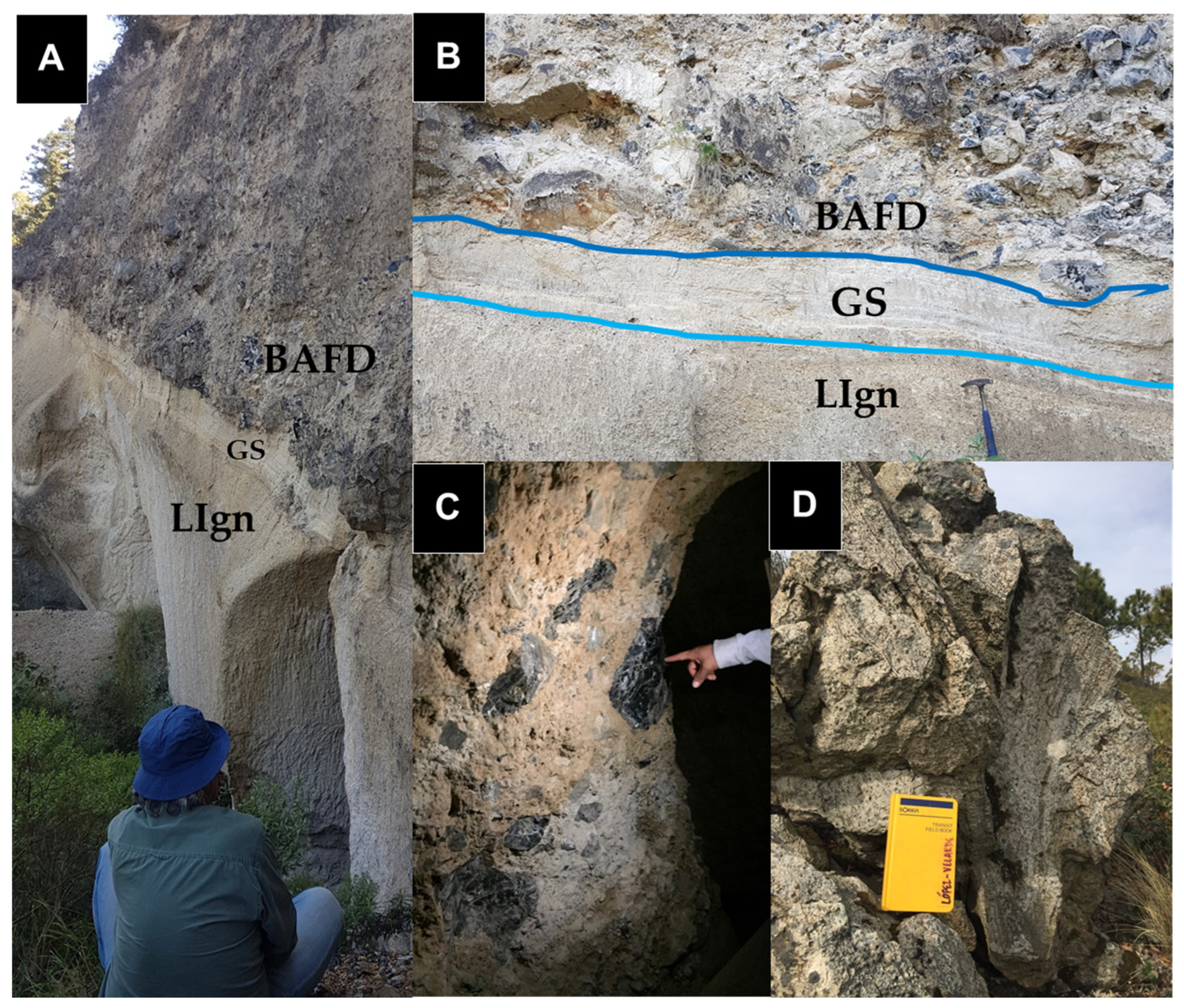
Figure 12.
In A Pumice Mine El Nopalillo showing the stratigraphic relation between EE3 and EE1. In B close up into the mine wall where the blue lines show the volcanic litofacies limit. In C inside of an underground obsidian mine in the Cerro de las Navajas research area. In D subvertical litofisal rhyolite in Cruz de Milagro. ACFD (Block and Ash Flow Deposit), GS (Ground Surge), Lign (Ignimbritic Lapillite).
5. Conclusions
The most significant archaeological obsidian deposit in Mesoamerica, Sierra de Las Navajas, is a volcanic complex of rhyolitic composition with a peralkaline affinity. The geochemical characteristics of their magma are rare within the TMVB province. Its eruptive episodes began with the formation of the paleo-volcanic edifice and culminated in its destruction through a large-scale Plinian (Mount St. Helens-type) lateral eruption. The complex contains subsources of obsidian with variations in vitreous material. Mineralogical and geochemical analyses confirmed differences between the obsidians from different eruptive events at Cerro de Las Navajas. Specifically, EE3 represents the volcanic deposit with the highest concentration of green-gold obsidian blocks, showing archaeological evidence of pre-Hispanic underground mining and extraction. The EE3 volcanic event is a pyroclastic phenomenon classified as a Block and Ash Flow Deposit (BAFD). This type of deposit is characterized by the sedimentation of large pyroclastic rock and ash blocks. In this case, the deposit contains green-gold obsidian blocks, rhyolitic rocks, and tuffs embedded in a volcanic ash matrix. This unit is covered by a different pyroclastic density current deposit with rare black-grey obsidian that probably derives from another volcanic vent not defined yet. The green-gold obsidian pyroclastic blocks, originally parts of a lava- dome, exhibit the high vitreous quality, shape and volumes sought by pre-Hispanic cultures of the Central Highlands. Currently, the local economy at Sierra de las Navajas is sustained through the mining of obsidian by the inhabitants of the Ejido El Nopalillo. Traditional exploratory methods, based on trial and error, continue to be used, often guided by the remnants of pre-Hispanic mining activities.
Supplementary Materials
The following supporting information can be downloaded at the website of this paper posted on Preprints.org.
Author Contributions
Jesús Roberto Vidal-Solano is the corresponding author who developed the scientific proposal. He also contributed to the interpretation of geological and analytical data, as well as fieldwork, and redaction of the MS. Alejandro Pastrana is a co-author of the proposal, defining the archaeological research problem and geoarchaeological studies conducted in Sierra de las Navajas. Gerardo Alonso López-Velarde contributing to manuscript writing, figure creation, and the interpretation of geological and analytical data. He was also responsible for the literature review and the identification of key research questions addressed in this study. All authors have read and agreed to the published version of the manuscript.
Funding
This research received no external funding.
Acknowledgments
We extend our gratitude to Dr. Diana Meza Figueroa for facilitating geochemical studies at the Crystallography and Geochemistry Laboratory of the Department of Geology at the Universidad de Sonora. We also thank M.C. Abraham Mendoza for his contributions to the X-ray Diffraction analyses conducted in the same laboratory. Special appreciation goes to technician Jorge Chan López for his support in preparing materials for petrographic analysis. Finally, we acknowledge and dedicate Dr. Luis Alva Valdivia† and his paleomag research team at the Institute of Geophysics of the National Autonomous University of Mexico, for their scientific and fraternal support and help in field work.
Conflicts of Interest
The authors declare no conflicts of interest.
References
- Brown, R. J., & Andrews, G. (2015). Deposits of Pyroclastic Density Currents. In H. Sigurdsson (Ed.), The Encyclopedia of Volcanoes (2nd ed., pp. 631–648). Elsevier. [CrossRef]
- Cobean, R. H. (2002). A World of Obsidian: The Mining and Trade of a Volcanic Glass in Ancient Mexico. Mexico City: National Institute of Anthropology and History.
- Cruz-Pérez, M., Canet, C., Pastrana, A., Domínguez-Peláez, S., Morelos-Rodríguez, L., Salgado-Martínez, E., Krieger, P., & Martínez-Serrano, R. G. (2019). The green and golden obsidian from Cerro de las Navajas: A geoarchaeological case study in the UNESCO Global Geopark “Comarca Minera”, Hidalgo, Mexico (abstract). In 5th Latin American and Caribbean Geoparks Symposium, Trinidad, Uruguay.
- Donato, P.; Donato, S.; Barba, L.; Crisci, G.M.; Crocco, M.C.; Davoli, M.; Filosa, R.; Formoso, V.; Niceforo, G.; Pastrana, A.; et al. Influence of Chemical Composition and Microvesiculation on the Chromatic Features of the Obsidian of Sierra de las Navajas (Hidalgo, Mexico). Minerals 2022, 12, 177. [CrossRef]
- Donato, P., Barba, L., De Rosa, R., Niceforo, G., Pastrana, A., Donato, S., & Crisci, G. (2017). Green, grey and black: A comparative study of Sierra de las Navajas (Mexico) and Lipari (Italy) obsidians. Quaternary International, 467(B), 369–390. [CrossRef]
- Ferrari, L., Orozco-Esquivel, T., Manea, V., & Manea, M. (2012). The dynamic history of the Trans-Mexican Volcanic Belt and the Mexico subduction zone. Tectonophysics, 122–149. [CrossRef]
- Heide, K., & Heide, G. (2011). Vitreous state in nature–Origin and properties. Chemie der Erde, 71, 305–335. [CrossRef]
- Lighthart, A. (2001). The geology, petrology, and geoarchaeology of Sierra Las Navajas, Hidalgo, Mexico. PhD Thesis, Tulane University, New Orleans, Louisiana, USA.
- López-Velarde, G. A. (2020). Geoarchaeology of obsidian deposits with pre-Hispanic exploitation in Sierra de las Navajas, Hidalgo, Mexico: Origin and petrographic identity. Master’s Thesis, Department of Geology, University of Sonora, Hermosillo, Sonora, Mexico. (177 pp.).
- Lailson, B. (2019). Archaeological explorations in Group 6B of the Sierra de las Navajas site. In N. Shulze, M. N. Caretta, & B. Lailson (Eds.), [Title of the book or proceedings]. [Publisher information].
- Nuñez-Velazquez, M. (2018). Las Navajas Volcano, State of Hidalgo: Geochemical and isotopic characteristics of peralkaline magmatism in the Trans-Mexican Volcanic Belt. Universidad Nacional Autónoma de México, Ciudad Universitaria, Mexico City.
- Pastrana, A. (1998). Geology of the Sierra de las Navajas deposit. In A. Pastrana (Ed.), The Aztec exploitation of obsidian in Sierra de las Navajas (pp. 39–59). Mexico City: National Institute of Anthropology and History.
- Pastrana, A. (2002). Variation at the source: Obsidian exploitation at Sierra de las Navajas, Mexico. In K. Hirth & B. Andrews (Eds.), Pathways to Prismatic Blades: A Study in Mesoamerican Obsidian Core-Blade Technology (pp. 15–26). Los Angeles, California: University of California.
- Pastrana, A., Fournier, P., Parry, W. J., & Otis Charlton, C. L. (2019). Obsidian production and use in Central Mexico after the Spanish invasion. In T. A. Rani (Ed.), Technology and Tradition in Mesoamerica after the Spanish Invasion (pp. 15–33). Albuquerque, New Mexico: University of New Mexico.
- Pastrana, A., & Carballo, D. M. (2023). Obsidian in Mesoamerica. In G. Adamson (Ed.), Obsidian (pp. 26–31). Milwaukee, USA.
- Pastrana, A., & Carballo, D. M. (2016). Aztec obsidian industries. In D. L. Nichols & E. Rodriguez-Alegria (Eds.), The Oxford Handbook of the Aztecs (pp. 329–341). Austin, Texas: The University of Texas at Austin.
- Pastrana, A., Domínguez, S., & Sterpone, O. (2011). Production and use of prismatic obsidian blades in Sierra de las Navajas: Tlamimilolpa phase. In L. Manzanilla & H. Kenneth (Eds.), Artisanal and Specialized Production in Mesoamerica: Activity Areas and Production Processes (pp. 153–176). Mexico City: Institute of Anthropological Research.
- Pastrana, A., & Domínguez, S. (2009). Changes in the strategy of obsidian exploitation from Pachuca: Teotihuacan, Tula, and the Triple Alliance. Ancient Mesoamerica, 129–148.
- Pastrana, A., & Fournier, P. (1998). Colonial exploitation of obsidian at the Sierra Las Navajas site. Mexico City: National Council for Culture and Arts.
- Saunders, N. J. (2001). A dark light: Reflections on obsidian in Mesoamerica. World Archaeology, 33(2), 220–236. [CrossRef]
- Tykot, R. H. (2021). Non-destructive pXRF on prehistoric obsidian artifacts from the central Mediterranean. Applied Sciences, 11, 7459. [CrossRef]
- Vidal-Solano, J. R. (2017). New considerations for the petrographic identification of obsidian: Implications for its physical and chemical characterization in Mexico. 2nd Symposium on Obsidian Research and Characterization in Mexico, Pátzcuaro, Michoacán, Mexico.
- Vidal-Solano, J. R., Gómez-Valencia, A. M., Hinojo-Hinojo, A., & Lozano-Santa Cruz, R. (2020a). Handheld X-ray fluorescence geochemical data of geological and archaeological obsidian from Sonora, Mexico. Data in Brief, 33, 106410. [CrossRef]
- Vidal-Solano, J. R., Gómez-Valencia, A. M., Hinojo-Hinojo, A., & Lozano-Santa Cruz, R. (2020b). Geochemistry and geological control of Sonora obsidian: New insights into the provenance study of archaeological obsidians in Mexico. Journal of South American Earth Sciences, 104, 102840. [CrossRef]
- Vidal-Solano, J. R., Lozano-Santa Cruz, R., Zamora, O., Mendoza-Cordova, A., & Stock, J. (2013). Geochemistry of the extendise peralkaline pyroclastic flow deposit of NW Mexico, based on conventional and handheld X-ray fluorescence. Implications in a regional context. Journal of Iberian Geology, 121-130.
Figure 1.
Geoarchaeological map of Mesoamerica, showing a) the main archaeological sites of Mesoamerica, b) the physiography of Mesoamerica, c) the cultural regions of Mesoamerica, d) the tectonic boundary of the Trans-Mexican Volcanic Belt (TMVB, Ferrari et al., 2012), and e) the tectonics associated with the Mesoamerican region. SLN = Sierra de las Navajas, OT = Otumba, PE = Pénjamo, ZPE = Zinapécuaro, UC = Ucareo, JY = Joya, RT = Rancho Tenango, PO = Pico de Orizaba, JIL = Jilotepec, CHY = El Chayal, OA = Ojo de Agua, TAJ = Tajumulco, MO-TE = Mora-Teuchtitlán.
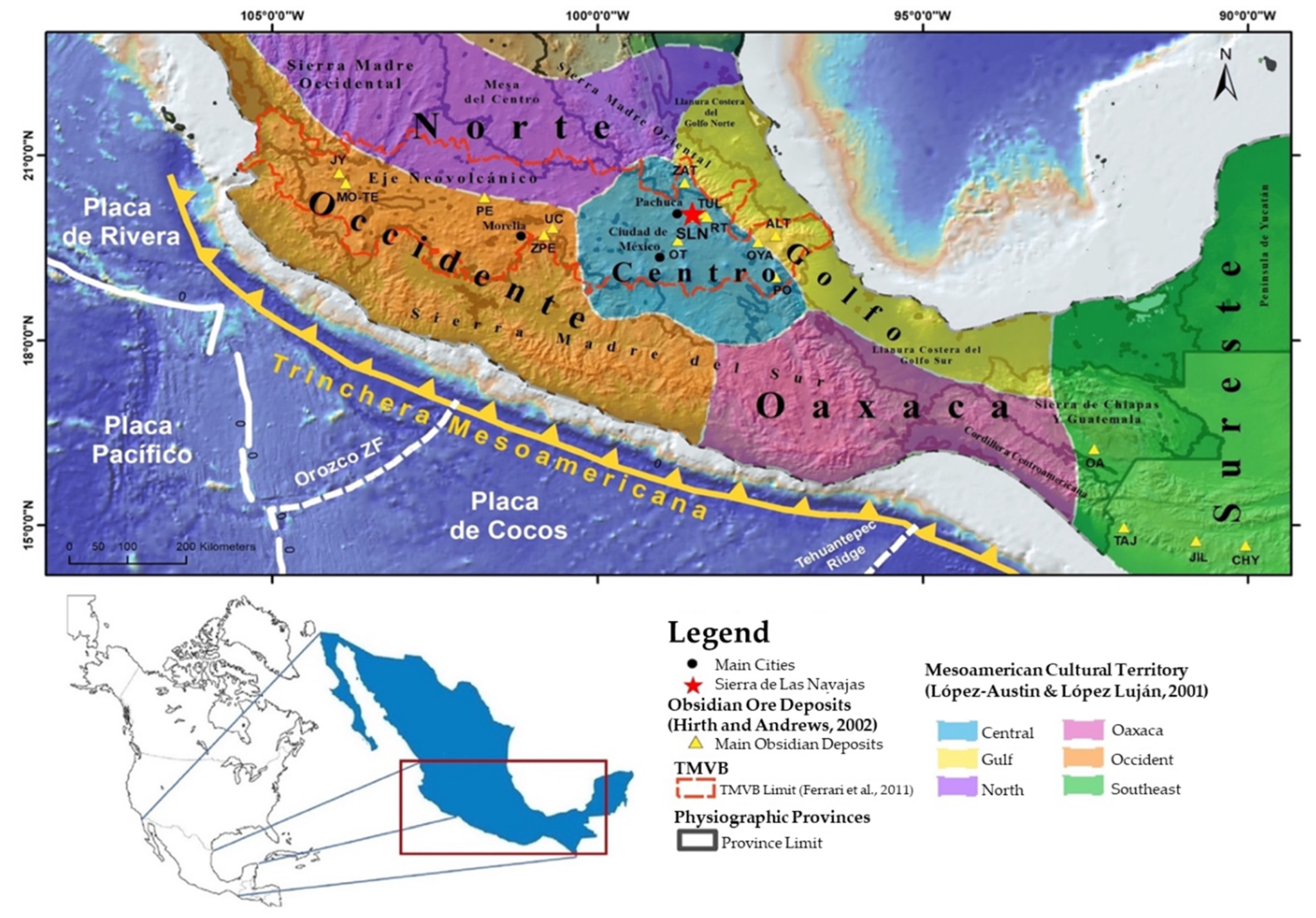
Figure 2.
Example of the selection of obsidian fragments for X-Ray Diffraction analysis. In A, the obsidian chips analyzed under a petrographic microscope are shown. In B, a 3 mm chip of green obsidian with a micro-phenocryst of pyroxene is shown under natural light and a 40X objective.
Figure 2.
Example of the selection of obsidian fragments for X-Ray Diffraction analysis. In A, the obsidian chips analyzed under a petrographic microscope are shown. In B, a 3 mm chip of green obsidian with a micro-phenocryst of pyroxene is shown under natural light and a 40X objective.
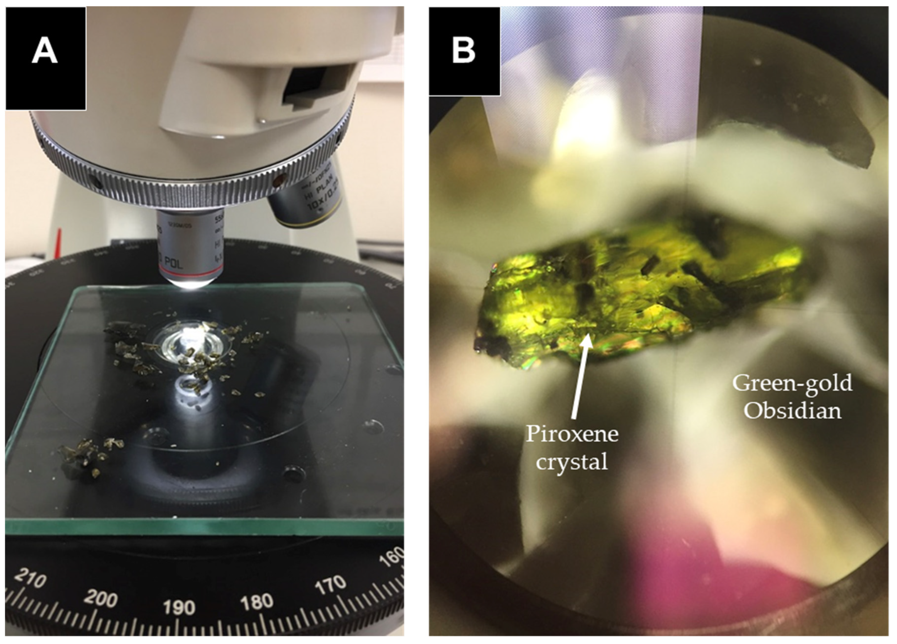
Figure 4.
Composite stratigraphic column summarizing the Eruptive Events (EE) in the Sierra de las Navajas region. In detail, it shows the stratigraphic column of the obsidian subsource at Cerro de las Navajas. The figure illustrates the main geological units with obsidian at the site, their physical characteristics, and the approximate thickness of each unit.
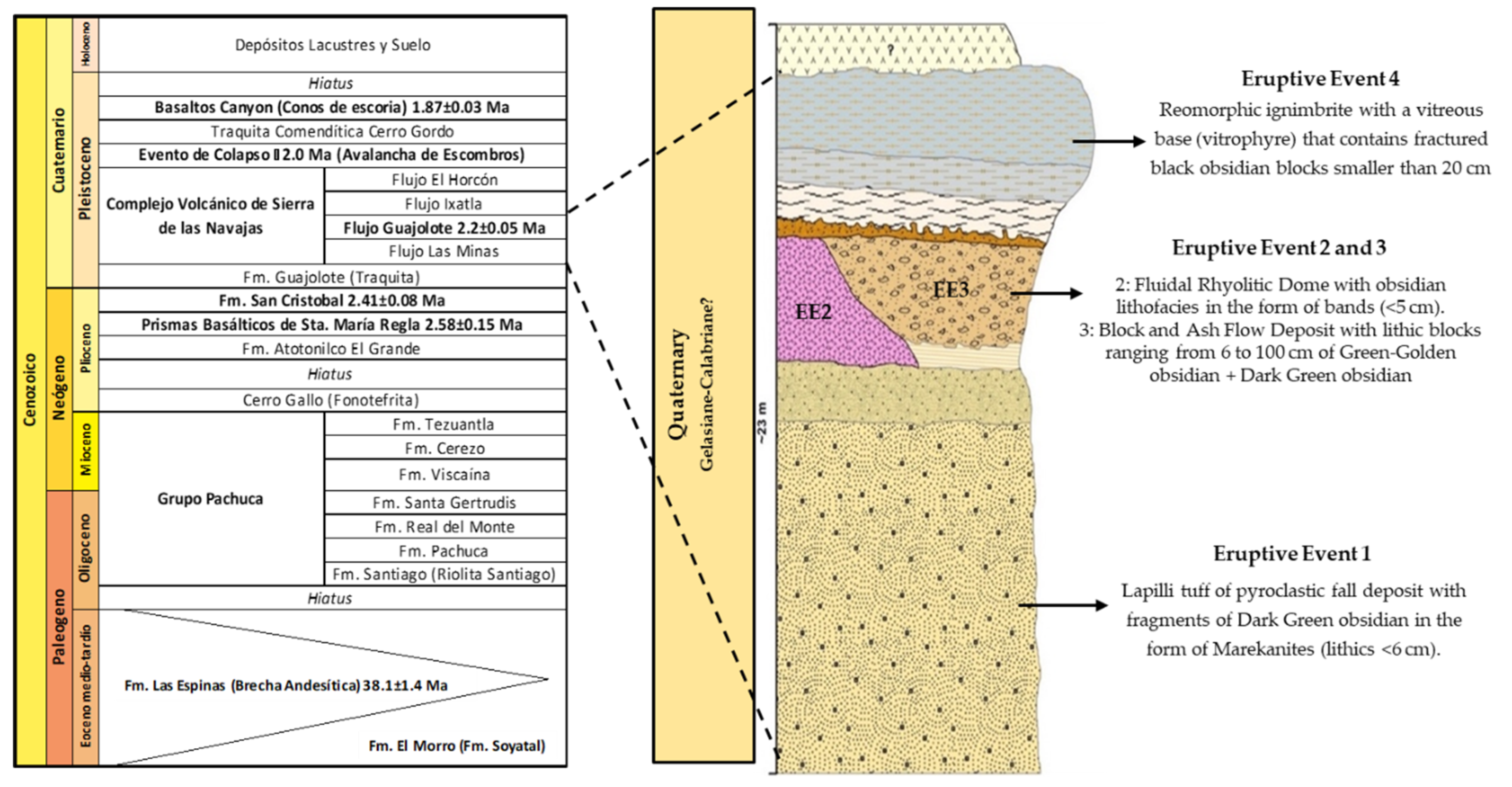
Figure 5.
Hand samples of obsidian from EE3 and EE4 (left and right, respectively). The main petrographic features in the samples are highlighted in the image. In A, a lithic block of green-golden obsidian is shown, where fluid inclusions mark the flow bands in the glass. In B, a polished surface (perpendicular to the volcanic stratification) of a fragment of black obsidian is shown, with phenocrysts of sanidine and flow bands of different colors.
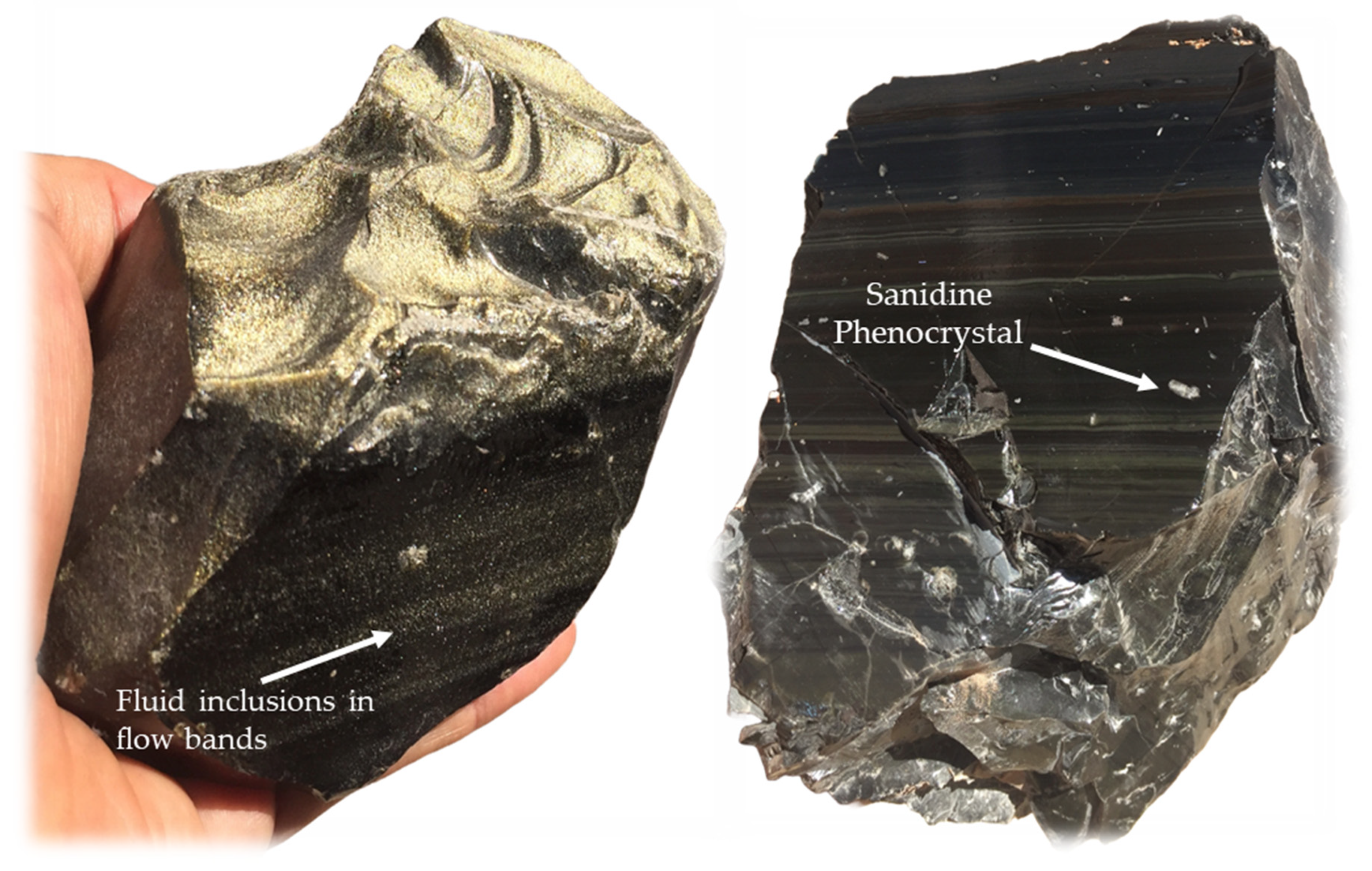
Figure 6.
Photomicrographs of cross-section cuts oriented according to the flow direction of a golden obsidian from EE3. A = Under analyzed light, a high content of angular fluid inclusions that dominate the golden obsidian is observed. B and C = Under analyzed light, with a higher magnification objective (10x), the occurrence of the inclusions is visible. Additionally, in C, the optical phenomenon producing the iridescence effect is shown. The yellow arrow indicates the flow direction in the sample, identified by the fluid inclusions. In E and F, microphotographs of the black obsidian from EE4 are shown, where in E, a subrounded phenocryst of Sanidine with inclusions of Aegirine is observed. In F, a flow microstructure is visible, indicated by the white and black arrows, which follows a ductile shear process occurring between lava flow planes.
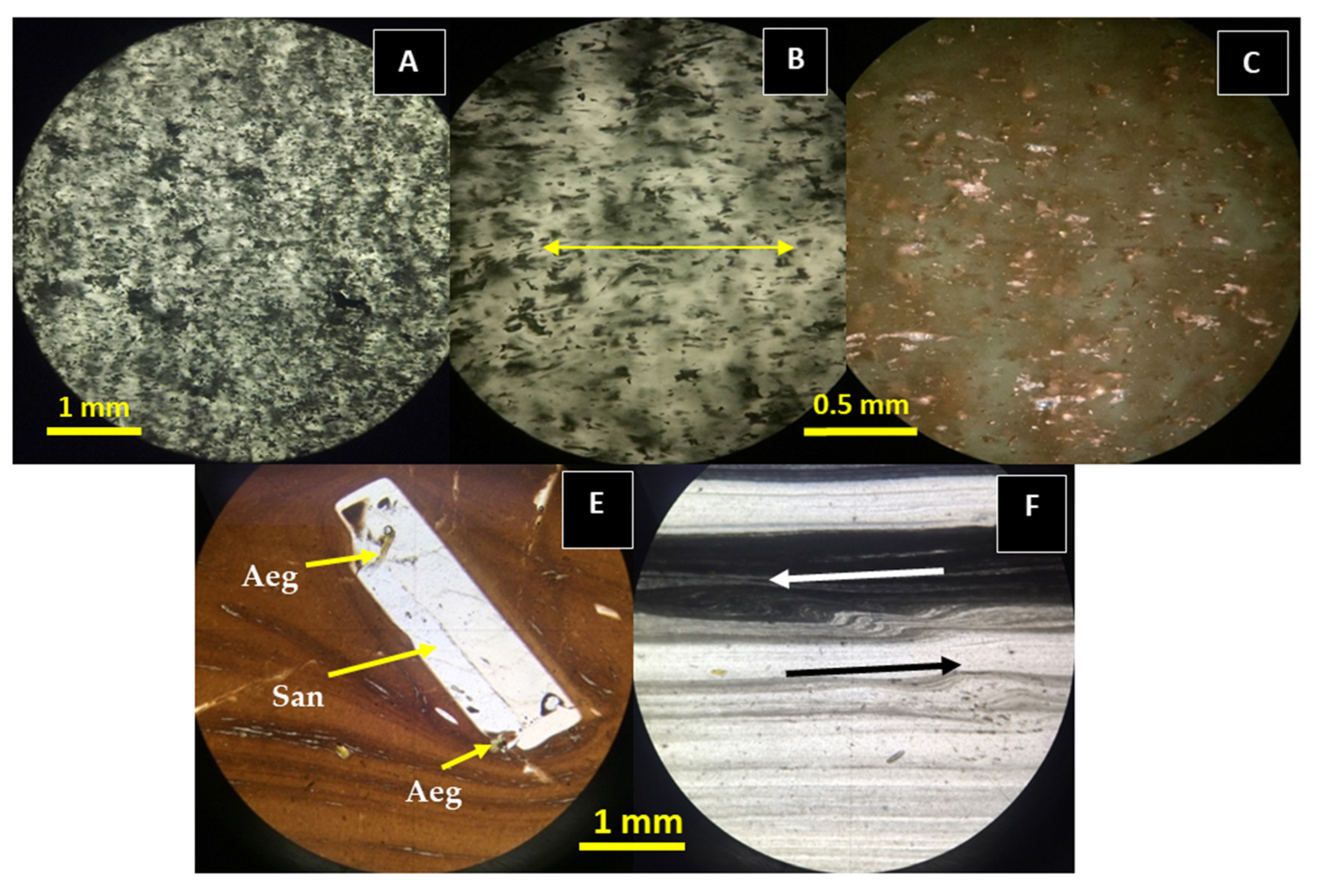
Figure 7.
In A, green-golden obsidian with a mineralogical association of Tridymite (Tri) + Sanidine (San) + Cristobalite (Cri), in that order of abundance, according to its mineral content percentage. In B, dark green obsidian, with a more complex mineralogical association of Pyroxene (Prx) + Tri + Cri + Carnegeite (Carn) + Quartz (Qz) + Fayalite (Fay), in that order of relative abundance.
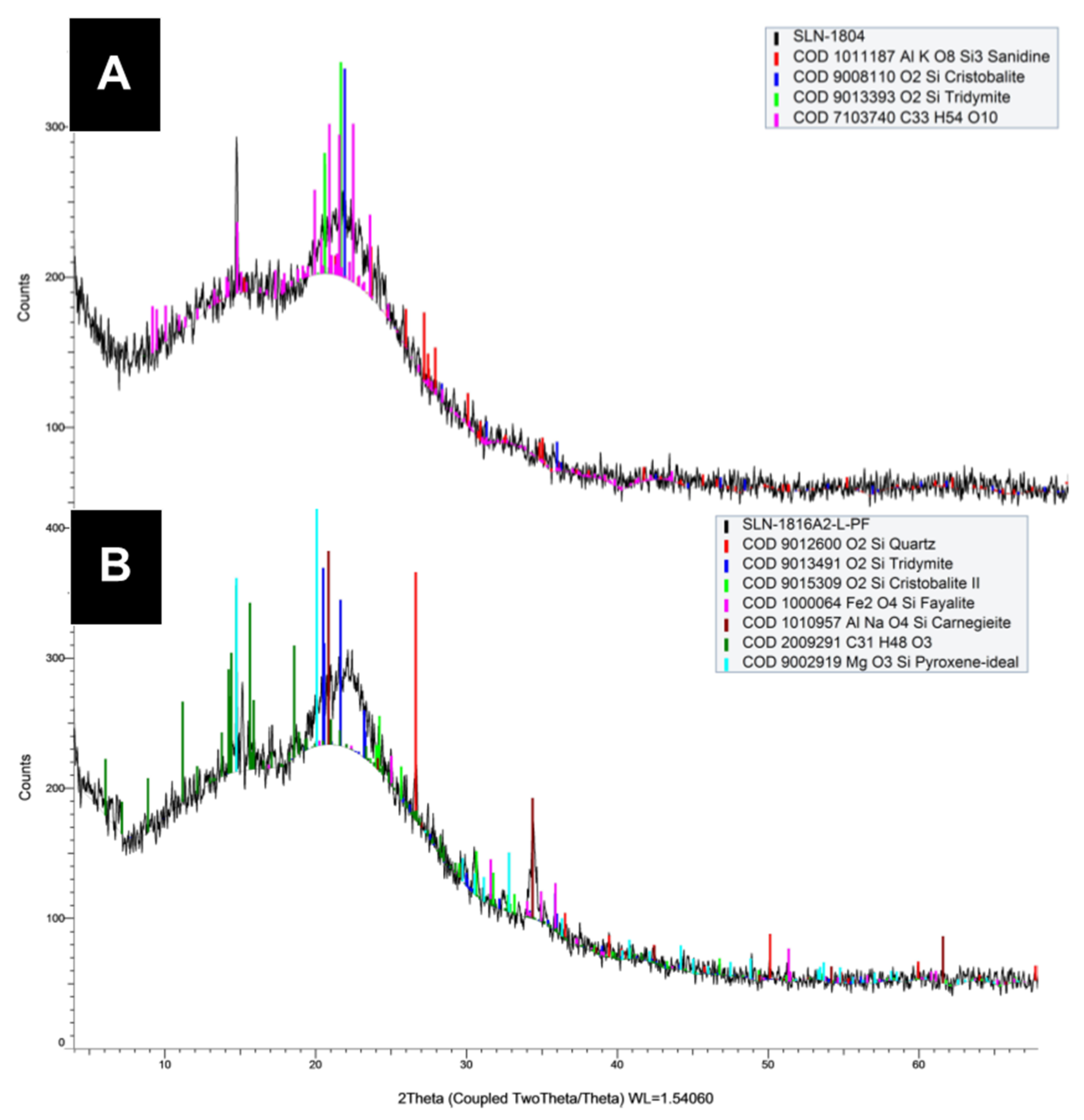
Figure 8.
Multi-elemental diagram normalized to a golden obsidian (type sample from the Cerro de las Navajas subsource), showing the variations between the obsidian samples with positive and negative anomalies.
Figure 8.
Multi-elemental diagram normalized to a golden obsidian (type sample from the Cerro de las Navajas subsource), showing the variations between the obsidian samples with positive and negative anomalies.
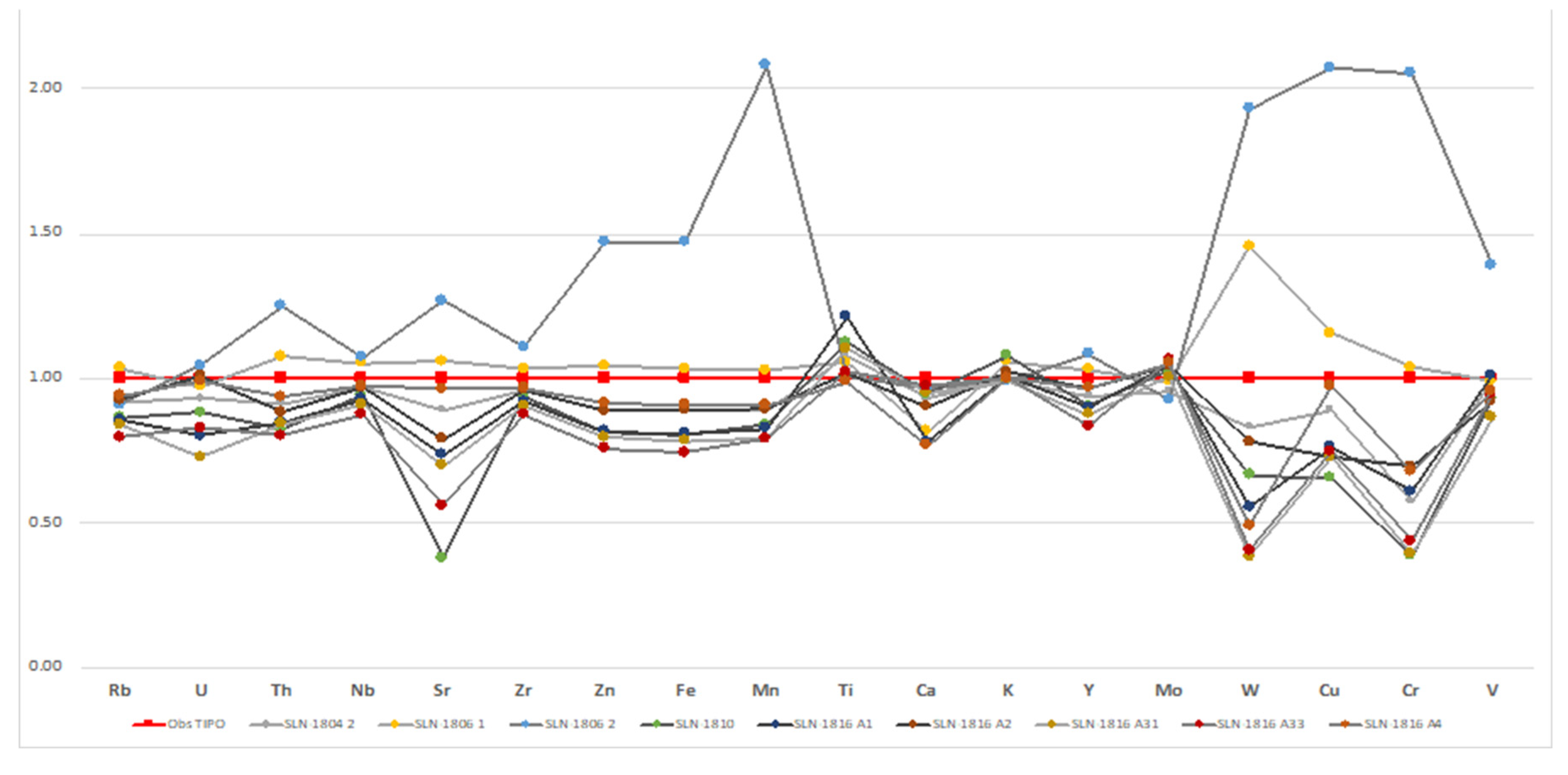
Figure 9.
Binary diagram Rb/Sr vs Nb/Y that discriminates the samples from the Eruptive Events in the Cerro de las Navajas stratigraphy.
Figure 9.
Binary diagram Rb/Sr vs Nb/Y that discriminates the samples from the Eruptive Events in the Cerro de las Navajas stratigraphy.
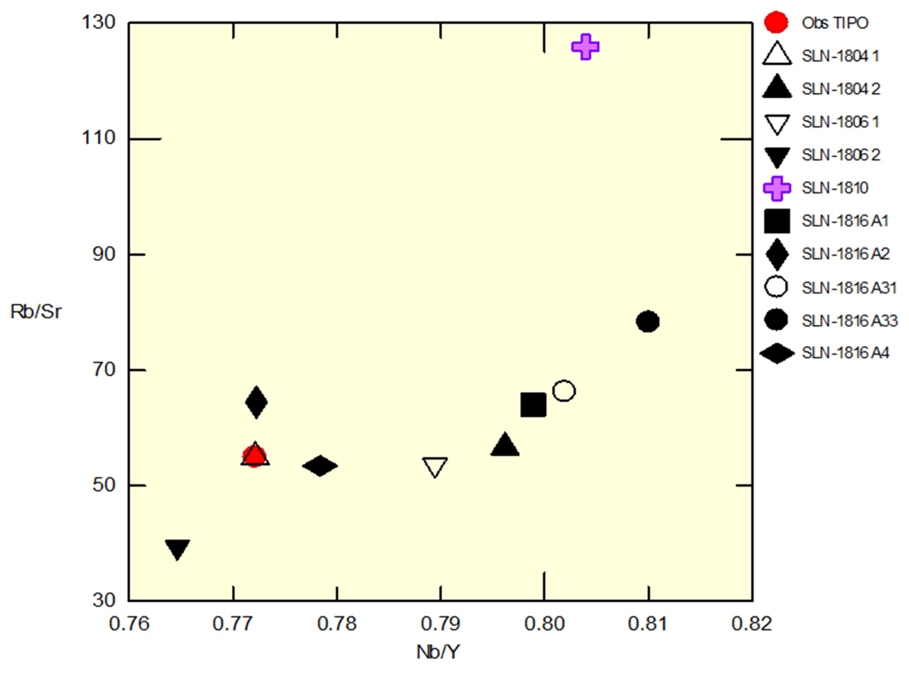
Figure 10.
Geodynamic evolution model of Sierra de las Navajas. The lava dome with dark green-golden obsidian shows several eruptive stages, where EE 1, 2, and 3 are manifested.
Figure 10.
Geodynamic evolution model of Sierra de las Navajas. The lava dome with dark green-golden obsidian shows several eruptive stages, where EE 1, 2, and 3 are manifested.
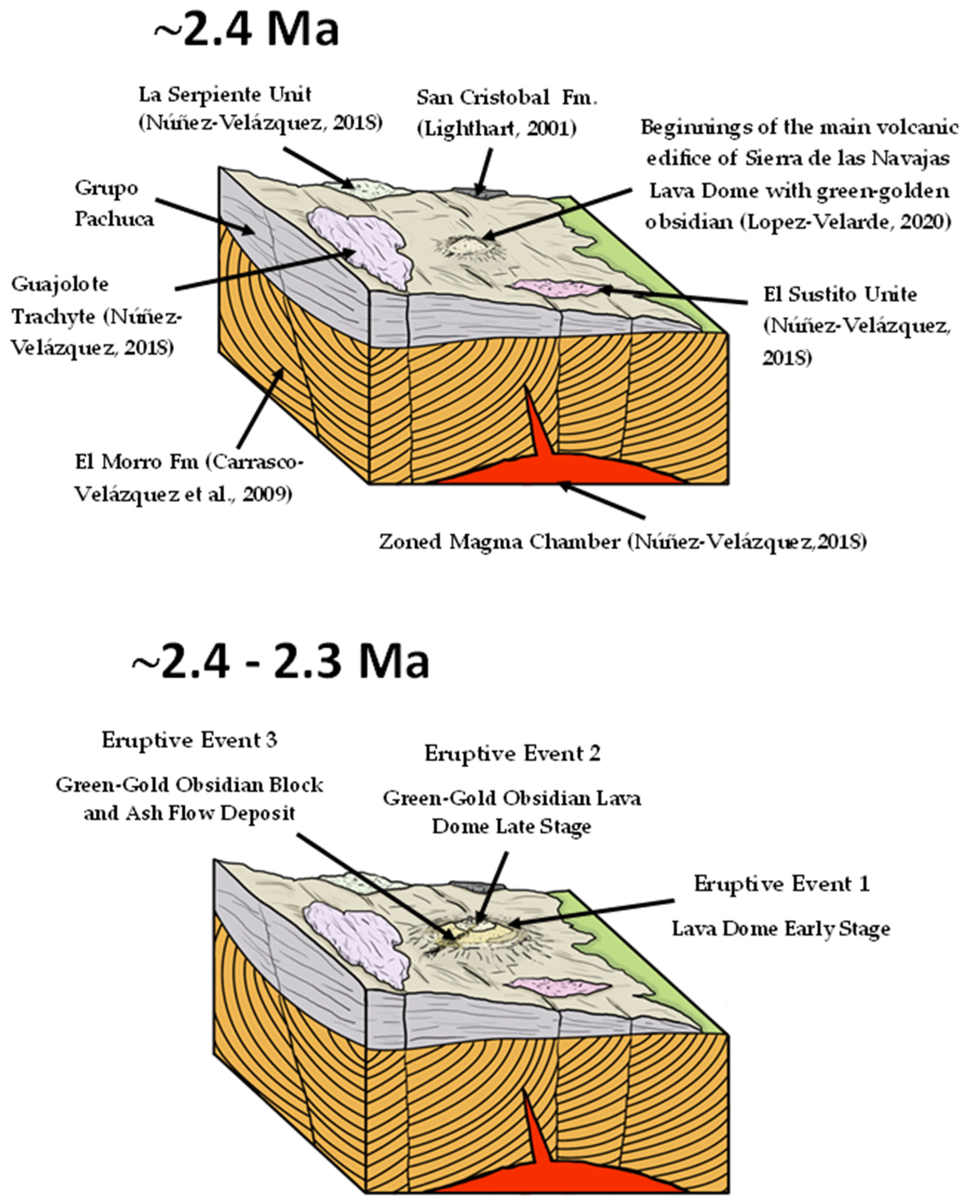
Figure 11.
Geoarchaeological map of the Cerro de las Navajas locality. The spatial distribution of the main volcanic units occurring as outcrops (EE1, 2, and 4) and subterranean (EE3), marked with dashed lines, is shown. Additionally, the main inferred structures (fractures and/or faults) are observed, which control the geological arrangement of the area. The chronological distribution of pre-Hispanic exploitation (Pastrana, 2002) and modern obsidian mining lots coincide in the same space, associated with the underground and interpreted mapping of the DFBC.
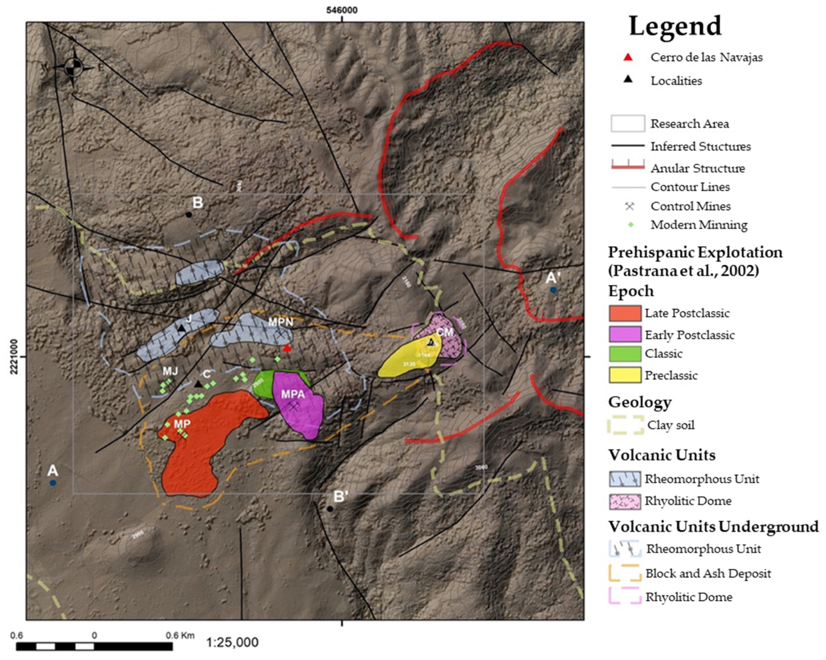

Table 1.
Geochemical concentrations in ppm of the EE3 obsidians from Cerro de las Navajas.
| Cerro de las NavajasObsidians | Zr | Error | Sr | Error | Rb | Error | Zn | Error | Fe | Error | Mn | Error | Ti | Error | Ca | Error | K | Error | Nb | Error | Y | Error | |
| Green Gold | SLN-1804 1 | 1187.44 | 7.18 | 4.01 | 0.91 | 231.58 | 4.16 | 243.67 | 9.17 | 17032.26 | 133.13 | 958.04 | 45.09 | 986.78 | 29.70 | 693.94 | 53.68 | 29324.37 | 208.25 | 108.44 | 2.75 | 140.44 | 3.41 |
| SLN-1804 2 | 1135.94 | 6.78 | 3.76 | 0.86 | 214.00 | 3.85 | 220.76 | 8.47 | 15069.73 | 121.09 | 847.91 | 41.77 | 1049.36 | 29.92 | 663.73 | 53.00 | 29010.87 | 206.72 | 104.93 | 2.61 | 131.79 | 3.18 | |
| SLN-1806 1 | 1232.01 | 7.23 | 4.58 | 0.92 | 243.64 | 4.19 | 263.94 | 9.40 | 17929.23 | 134.22 | 1002.97 | 45.24 | 1072.06 | 31.04 | 603.13 | 54.84 | 31657.63 | 217.86 | 113.98 | 2.76 | 144.38 | 3.39 | |
| SLN-1806 2 | 1365.81 | 11.98 | 4.89 | 1.07 | 154.52 | 3.96 | 390.89 | 14.53 | 27562.30 | 202.67 | 2713.25 | 113.68 | 975.45 | 29.14 | 698.51 | 52.32 | 28837.29 | 204.03 | 116.34 | 3.14 | 152.15 | 3.95 | |
| Marekanite | SLN-1810 | 1112.97 | 6.38 | 1.60 | 0.88 | 199.96 | 3.55 | 201.09 | 7.72 | 13670.04 | 109.67 | 804.78 | 39.08 | 1161.58 | 32.35 | 728.42 | 57.80 | 31268.45 | 226.83 | 101.83 | 2.45 | 126.66 | 2.96 |
| Dark Green | SLN-1816 A1 | 1091.17 | 6.37 | 3.26 | 0.81 | 197.42 | 3.59 | 200.52 | 7.77 | 13775.01 | 111.75 | 800.58 | 39.42 | 1009.76 | 31.76 | 562.59 | 53.65 | 29634.40 | 212.73 | 100.59 | 2.46 | 125.91 | 2.97 |
| SLN-1816 A2 | 1140.45 | 6.69 | 3.43 | 0.84 | 214.18 | 3.82 | 217.67 | 8.29 | 15143.61 | 120.00 | 841.16 | 41.39 | 1013.86 | 29.95 | 681.24 | 53.81 | 30193.29 | 211.25 | 104.74 | 2.58 | 135.63 | 3.17 | |
| SLN-1816 A31 | 1071.33 | 6.32 | 2.97 | 0.80 | 194.83 | 3.55 | 196.01 | 7.70 | 13323.44 | 109.56 | 754.52 | 38.77 | 1127.85 | 30.76 | 717.42 | 53.76 | 29126.22 | 209.28 | 98.48 | 2.44 | 122.80 | 2.94 | |
| SLN-1816 A33 | 1036.02 | 6.20 | 2.47 | 0.79 | 184.76 | 3.45 | 185.89 | 7.51 | 12651.31 | 106.54 | 766.58 | 38.84 | 1017.90 | 30.16 | 725.44 | 54.40 | 29374.00 | 211.38 | 94.71 | 2.39 | 116.92 | 2.86 | |
| SLN-1816 A4 | 1147.73 | 6.83 | 4.20 | 0.88 | 218.60 | 3.90 | 227.76 | 8.61 | 15406.52 | 122.63 | 857.05 | 42.17 | 966.92 | 29.60 | 563.39 | 52.55 | 29114.55 | 208.75 | 105.33 | 2.63 | 135.32 | 3.23 | |
Disclaimer/Publisher’s Note: The statements, opinions and data contained in all publications are solely those of the individual author(s) and contributor(s) and not of MDPI and/or the editor(s). MDPI and/or the editor(s) disclaim responsibility for any injury to people or property resulting from any ideas, methods, instructions or products referred to in the content. |
© 2025 by the authors. Licensee MDPI, Basel, Switzerland. This article is an open access article distributed under the terms and conditions of the Creative Commons Attribution (CC BY) license (http://creativecommons.org/licenses/by/4.0/).
Copyright: This open access article is published under a Creative Commons CC BY 4.0 license, which permit the free download, distribution, and reuse, provided that the author and preprint are cited in any reuse.


