
Submitted:
14 March 2025
Posted:
14 March 2025
You are already at the latest version
Preprints on COVID-19 and SARS-CoV-2
Abstract
The spatial structure of a city, consisting of the transportation network and activity centers, is a key factor affecting the mobility of people. The mobility of people during infectious diseases is the most important factor in the spread of the disease. Evaluating urban spatial structure and restructuring it is an important non-pharmaceutical way of controlling infectious diseases such as COVID-19. The present study investigates the interlinkages between Ahvaz's urban spatial structure and COVID-19. Spatial statistics were used to identify functional cores and analyze population distribution and employment by analyzing statistical block data and land-use layers. Pearson's correlation test was also applied to examine the relationship between functional cores, population, and employment. The results showed that population and employment have a clustered distribution pattern, as they are highly concentrated in the middle parts of Ahvaz. The city’s central part has the highest concentration of travel-absorbing uses. This increases the vulnerability and infection of COVID-19. The findings of this study can guide efforts aimed at modifying the urban structure of the city to make it more resilient to pandemics. Among other things, decentralization of activities, land use diversification, and promotion of urban sub-centers should be prioritized.
Keywords:
Spatial Structure
; Urban form
; Land-Use
; Urban planning
; COVID-19
1. Introduction
The rapid COVID-19 outbreak led to unprecedented problems and damages in many cities around the world, indicating the need for revisiting urban planning and design practices and paradigms(Andrianou et al., 2021)(J. Wang et al., 2021)(Megahed et al., 2024). Cities have traditionally been sensitive to the spread of diseases(Reyes et al., 2013). The importance of built environment design and characteristics for public health has been recognized since the late 19th century when major cities worldwide had to deal with infectious diseases such as influenza(Frank & Wali, 2021; Howard Frumkin et al., 2005). Despite various efforts to enhance urban public health, the spread of COVID-19 showed that urban environments are still very vulnerable to infectious diseases(Bereitschaft & Scheller, 2020; Sharifi, 2022). Two important measures that governments have taken to control COVID-19 are social distancing and travel restrictions. These measures have caused changes in volume, demand, and travel characteristics(Arimura et al., 2020). Travel characteristics depend on the characteristics of the built environment, including density, land use mix, and service accessibility.
Built environment characteristics can have implications for human health as shown in different urban contexts(J. Wang et al., 2021). Evidence also shows that the way built environments are designed can enhance or undermine human and societal health, for example, by reducing or increasing stress, and affecting the level of exposure to harmful environmental factors (such as air and noise pollution, and viral diseases)(Hankey et al., 2012; Huang et al., 2020; Jackson et al., 2013). Several studies have also shown that built environment factors such as density, connectivity, and accessibility can affect the spread dynamics of COVID-19(Kulu & Dorey, 2021)(Nguyen et al., 2020)(Nguyen et al., 2020)(Allam & Jones, 2020).In their review of 25 empirical studies,Wang et al. (2021) showed that the rate of infection with COVID-19 has a positive relationship with the density of commercial land-uses, roads, schools, and public transportation, and a negative relationship with access to green spaces.
Niu et al. (2021) examined the effects of built environment factors on COVID-19 infection in different age groups (elderly, middle-aged, and young) and reported interesting results. For instance, the density of green spaces and sports facilities due to increased interactions and the weak immune system of older adults have a positive effect on their infection rate. However, the greater the access to open space, the lower the infection rate. On the other hand, the density of public transportation stations can contribute to increasing the incidence of middle-aged and young people who are more reliant on such services Li et al., (2021) investigated the relationship between built environment characteristics and COVID-19 infection clusters using structural equation modeling in China. They concluded that built urban environments with dense commercial centers and concentrated public transportation infrastructure could increase the infection rate. Using GIS data analysis, Mouratidis (2021) showed that reliance on public transportation, small housing size, and limited access to open and green spaces affect the spread of COVID-19 in Oslo (Norway). On the other hand, decentralization and dispersion of facilities and services among different neighborhoods at the city level could contribute to better control of the disease In another study, X. Niu et al. (2020) examined the spatial and urban factors affecting the spread of COVID-19 in China, and concluded that the concentration of production centers leads to an increase in inter-urban movements and could contribute to the spread of COVID-19.
Different forms of the built environment could affect the space-time patterns and the number of social interactions(Sharifi, 2019b, 2019a). Characteristics such as form (monocentric or polycentric), land-use, density, and access could affect the extent of interactions between urban residents and are likely to have significant impacts on the transmission of viral diseases. Moreover, different housing types and the amount of green space in an area may be important factors in facilitating social distancing and reducing crowding, which could contribute to better disease control. Certain types of places and areas (such as cafes, restaurants, etc.) where crowding could occur could contribute to the spread of infectious diseases(Frank & Engelke, 2001; Huang et al., 2020).
In monocentric cities, urban activities are concentrated in a single center. Such concentration is desirable in some places as it could decrease the cost of transporting goods and exchanging services and offer better opportunities for the provision of specialized services and products(Angel & Blei, 2016). In contrast, polycentric cities are characterized by having multiple activity centers(Sat, 2018). Having multiple centers could decrease urban crowding and contribute to better disease control.
Based on what is discussed above, it could be interpreted that, in the absence of proper control measures, a high concentration of people, activities, and services in certain urban centers could increase the risk of COVID(Aguilar et al., 2022; Gaisie et al., 2022; Yip et al., 2021). However, to the best of our knowledge, there is still a lack of studies examining the effects of urban mono/poly-centricity on the spread of COVID-19.
Non-pharmacological interventions and controlling the spread of COVID-19 are still a priority in many cities despite widespread vaccination in some contexts and advances in the treatment of the disease(Sung, 2022). Ahvaz, the most populous city in South West Iran, has experienced rapid and unbridled growth in recent years and has witnessed drastic demographic and physical changes due to natural population growth, immigration, expansion of services, and other social and economic changes. Accordingly, its population has increased by a factor of over 10 over the past decades (from 120,089 in 1957 to 1,064,177 in 2012). The city was one of the main hotspots of COVID-19 in Iran. Like other cities, non-pharmacological interventions were one of the most important strategies to control Covid-19 in Ahvaz. The city is characterized by a monocentric urban structure that could have made the control of the pandemic more challenging. Therefore, this study aims to investigate the city's spatial structure and to examine interlinkages between urban structure and COVID-19. The results of this study could provide insights for developing more effective urban planning and design policies and practices that contribute to improved control of infectious diseases in cities. It also shows the importance and effectiveness of non-pharmacological interventions mediated by the structure and built environment.
2. Materials and Methods
2.1. Study Area
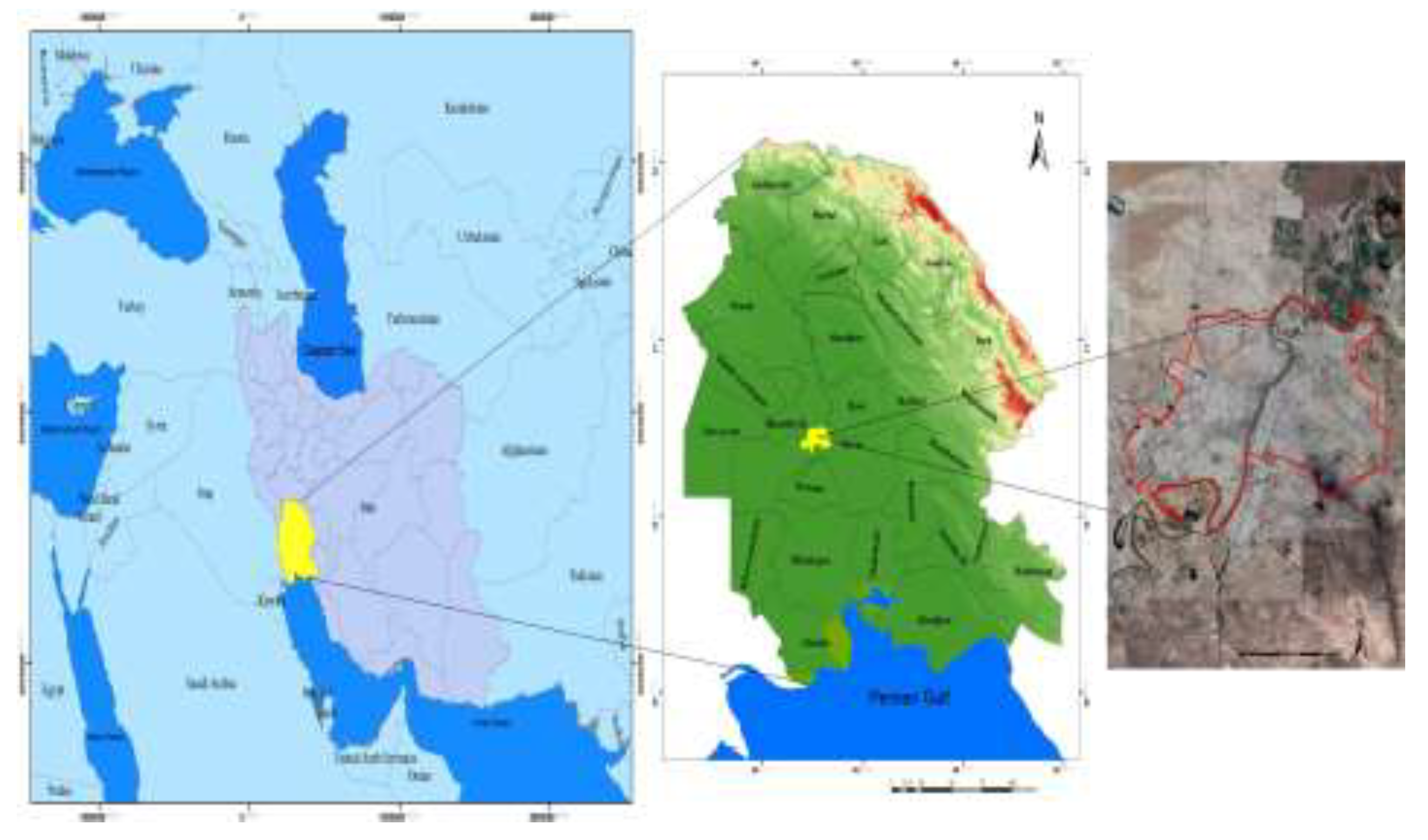
Ahvaz, the capital of Khuzestan province, is a major city located in southwestern Iran. Ahvaz has eight municipal districts. The city coordinates are 31°19'38.4074", 048°40'30.1944", the altitude is 18 meters above sea level, its population is 1.3 million, and the total area is 220 square kilometers(Alavi et al., 2015). Ahvaz is located in the dry region of Iran with extreme heat, and its average annual rainfall is about 250 mm(Goudarzi et al., 2015). The city has been dealing with many environmental issues in the past few decades. Given the high PM10 concentrations, in 2011, the World Health Organization named Ahvaz as the worst city in the world in terms of air quality(Farsani et al., 2018). The city is also frequently hit by dust storms(Boloorani et al., 2021).
Figure 1.
Figure 1. Location of Ahvaz.
The city was one of the epicenters of the COVID-19 pandemic in Iran. More than 75,000 people in the city were infected with COVID-19 in one year; from October 2020 to September 2021 (According to Ahvaz Jundishapur University of Medical Sciences). Figure 2 shows the spatial distribution of COVID-19 patients in Ahvaz.
2.2. Research met Hods
This study aimed to investigate the urban structure and its relationship with COVID-19 using a cross-sectional timeframe. To this end, a spatial analysis was performed. In the first step, Ahvaz's urban structure was investigated to find out whether it is monocentric or polycentric. In the second step, the volume of pedestrians in the main core of the city was obtained using field observations and used for further analysis of the associations between urban form and COVID-19.
2.2.1. Collecting Data
We collected the required data in three parts, according to the research goal. In the first part, data was used to investigate the spatial structure of Ahvaz and identify its functional cores. Land use layers and the city statistical block data from the 2016 National Population and Housing Census served as the data sources (amar.org.ir). The statistical blocks provided the data needed to analyze population and employment distribution. The city's monocentric or polycentric structure was also determined using land use data. This section's analysis was done at a neighborhood level.
In the second part, the survey method was used to investigate the pedestrians' status in the city center and estimate the walking rate in each street of the city's main core. The survey was conducted in 2020, between Iran's first and second COVID-19 peaks. Paper forms were provided to surveyors to collect pedestrian statistics, and they counted and recorded the number of pedestrians in predetermined places at 15-minute intervals. Following the collection of pedestrian flow data in all predetermined passages, the data was entered into Microsoft Excel, and the necessary maps were created in ArcGIS software.
In the third part, we used the COVID-19 cases collected from September 2020 to August 2021 by Jundishapur University of Ahvaz to show the spatial distribution of COVID-19 cases.
2.2.3. Analysis Process
Different procedures taken in this research are shown in Figure 3. To analyze the spatial structure of the city, spatial statistics were used in ArcGIS software10.8. Moreover, hot- and cold- spots and the spatial autocorrelation test were used to analyze population and employment distribution patterns. Then, the number and area of travel-absorbing uses were calculated for the neighborhoods in the city. Kernel density, spatial autocorrelation test, and mean center were exerted to identify functional kernels. Pearson's correlation was used in SPSS software23 to investigate the relationship between functional kernels and population and employment.
The spatial statistics that were used in this study to identify sub-centers have also been validated in previous studies(Arribas-Bel & Sanz-Gracia, 2014; Cuthbert & Anderson, 2002; Pereira et al., 2013; C. H. Wang & Chen, 2015; Yang et al., 2012). We also used spatial usage statistics to identify performance cores from travel absorbing uses instead of job density rates. This approach was adopted because employment is registered based on the place of residence in the census, but the place of activity and work could be different.
3. Results
Population and employment distribution in Ahvaz
The distribution of population and employment in Ahvaz was investigated using hot spot analysis. As can be seen in Figure 4, the blue spots (cold spots) are areas where the population in the city has a low density, and the red spots (hot spots) are areas where the population has a high density. Population density is low in the central part of the city, where the market, offices, and administrative services are located. Population density is also low in the southern and eastern parts of the city. In contrast, it is high in western and northern parts3.1.
The hot- and cold- spots of employment distribution in Ahvaz are almost the same as the those for population distribution. The red and dense spots are located in the middle parts of the city, and cold and less dense parts are located in the outskirts and center of the city (Figure 6):
The functional cores in Ahvaz were determined using travel-absorbing land uses. The number of users in each neighborhood was calculated. Then, using this data, the necessary maps were prepared with the kernel tool. In general, District No.1 (i.e., Bagh Moein(1), 30-Metri(35), Bazar Abdul Hamid (33), Bagh Sheikh(32), and Saebin Mandaei (12) neighborhoods) have the highest concentration in terms of travel-absorbing uses and thus this region is the main core of the city. Besides, Lashkar Abad(77),Kampolo jenoobi(70), Zeyton Karmandi(103) are sub-cores. Table 1 shows the different cores and their neighborhoods:
In the Figure No. 6, the functional cores are shown separately and then integrated functional cores are presented in Figure No. 7
In Table 2, the ratio of each neighborhood's total uses to the city's total uses (travel absorbing uses) is calculated. This ratio shows the impact of each neighborhood on the functional cores of Ahvaz. The neighborhoods marked in yellow are the neighborhoods in a city where the most travel-related uses are located.
2.1. Mean Center
The Mean Center is the simplest analysis in spatial statistics. This analysis is similar to the mean in ordinary statistics. It identifies a set of complications in the geographic center or center of gravity. The central Mean is used to examine the concentration of the functional cores in Ahvaz. As displayed in Figure 8, the center of gravity of all functional cores is in one area in the city, which shows a monocentric structure.
Pearson's correlation was used to check the correlation between functional cores, population density indicators, distance from the city center, and the proportion of employed people. The data in Table 3 confirms a positive significant relationship (r = 0.403) between the functional cores and population density because the population density is lower in the regions where the market and offices are located. A significant and negative relationship was found between the functional cores and the distance from the city center. Thus, as the distance from the central part of the city increases, the functional cores decrease. A relatively high and significant relationship was also found between functional cores and the number of employees.
2.2. Counting the Number of Pedestrians Along the Length and Width of the Streets
Since the land uses and activities located in the central core of cities attract travel for commercial, medical, educational, recreational, and other purposes, heavy pedestrian traffic in the central areas of cities is unsurprising. The more vehicular traffic restrictions are, the more the number of pedestrians traveling in the city's central core, and the length of the walking journeys will increase.
Many travel-attractive uses are located in the central core of Ahvaz. Numerous commercial, medical, and educational centers, wholesale markets, and specialized markets for gold, aquatics, electronics, etc., are located in the city's central core. One key problem is that, due to the limited space of the central core, the heavy concentration of different activities and services increases pedestrian traffic. While Ahvaz has an area of about 220 square kilometers, the area of the main part of the central core of the city with the highest power to attract travelers is less than 1 square kilometer. In other words, it accounts for less than 0.5% of the total area of the city. On the other hand, a significant part of the main bus and taxi terminals of Ahvaz also ends in this area. Thus, if a person intends to travel from the west to the east of Ahvaz and vice versa, s/he must pass through this area. The problem becomes more acute when the eastern terminals are about 1 km away from the western terminals. As a result, pedestrians must travel the length of the central core of the city to go from one terminal to another, leading to significant pedestrian traffic in the central core.
Longitudinal and transverse pedestrian traffic was measured in places in the central core of Ahvaz to investigate the patterns of pedestrian change and identify the main and major pedestrian traffic locations. Currently, some parts of the central core of Ahvaz have been changed to pedestrian paths, and some parts with pedestrian priority. For instance, Imam Khomini Street is one of the important sidewalks of the city. Moreover, Salman Farsi Street is approximately 1300 meters long and has been designed with priority for pedestrians, and the sidewalks in this thoroughfare occupy a greater area than its riding surface.
We estimated the share of hourly pedestrian traffic in the total statistics compared to the maximum traffic. These data help determine the busiest hours of pedestrian traffic. Results show that pedestrian traffic peaks in the evening. Moreover, this crowding pattern grew significantly from 18:00 to 20:00.
A representation of the longitudinal pedestrian volume in the range is shown in Figure 9. In the inner limits of the CBD, with sidewalks accounting for a significant part, pedestrian traffic is quite significant. More than 700 pedestrians have crossed a section of Imam Khomeini Street in just 15 minutes. Since this area is a covered market (arcade) occupied by many shops, a large number of pedestrians pass through this crossing. Thus, despite a lower number of pedestrians compared to some other areas, it is always crowded and the traffic density is relatively high.
Shariati Street, between Salman Farsi and Imam Intersection, is also a bustling pedestrian section on the eastern side of the area. Thus, in a 15-minute peak, more than 1200 pedestrians have crossed, recording the highest traffic figure for pedestrians. On the western side of this area, the situation is the same as on the eastern side. There are more than 1200 pedestrians on Azadegan Street. Due to the occupation of the west side of the street by banks and the east side by the bus terminal at the beginning of Azadegan Street, as well as the prohibited entry of private vehicles from Salman Farsi Bridge to Azadegan Street, pedestrians can pass more calmly at the beginning of this axis.
The number of pedestrians crossing some parts of the city's central core is shown in Figure 9. At the intersection of Salman Farsi, the southern side is busy and has congestion and vehicle interference. The transverse traffic volume of more than 500 people in 15 minutes is relatively high, which interferes with the south-north direction of Shariati Street and the circling movements in this intersection. In the eastern part of this intersection and between Shariati Boulevard and Shahid Adham Street, the volume of transverse pedestrians crossing Salman Farsi Section is relatively high, accounting for more than 900 people in 15 minutes.
Another important crossing, with a relatively higher volume of transverse pedestrians compared to the speed and volume of passing cars, is Azdegan Boulevard. At the beginning of the boulevard, the transverse volume is relatively high, with about 500 people crossing in 15 minutes. As we move to the north of this passage, the volume of the crossing decreases.
As mentioned earlier, severe restrictions were applied to the CBD and the central market of Ahvaz during the COVID-19 peak. The city's central market was closed due to the quarantine, and even physical obstacles were applied to implement movement restrictions. Figure 10 shows physical obstacles and the closure of the market.
Figure 11 shows the number of longitudinal pedestrians in a day with traffic restrictions. It indicates that the pedestrians' number is much less than in Figure 9. For example, on Shariati Farsi Street, the number of pedestrians during the implementation of movement restrictions was 4360, while it was about 21944 in normal conditions.
Figure 12 depicts the amount of transverse pedestrian traffic. It shows, for example, that 2163 people have been calculated in Salman Farsi Street for the whole day. Although the market was closed and access to services and offices was also limited, pedestrians had to travel to the city center, walk part of the urban core to get to other parts of the city, and use taxi services to get around. The residents of one area of Ahvaz city also passed through the central streets to access local services such as supermarkets.
4. Discussion
This study investigated the mutual effect of the urban structure of Ahvaz and COVID-19 based on land use and population data, pedestrian rate, and spatial data. The findings showed that Ahvaz has a monocentric structure and most of the services and travel-attractive uses are concentrated in the central urban areas. The rate of pedestrians in the center of the city was calculated using a field survey. It showed that during the days that there were no quarantine restrictions, the rate was very high, and almost 700 to 1200 pedestrians cross the streets in the center of Ahvaz. As a result, the city center maintained its function even during the pandemic and only became empty of the population during physical restrictions implemented to curb the virus. This finding contrasts with the results of Gramsch et al. (2022) who found out that COVID-19 caused changes in urban mobility, with major effects on urban transport patterns, notably in the CBD of Santiago, Chile.
During the COVID-19 outbreak, several factors caused travel to the city center to remain unchanged, including the limited access to and lack of diversity in urban services in the peripheral areas of Ahvaz, poor technological literacy to use online shops, the absence of suitable infrastructure for remote working, and the existence of service works and vending in the city center. Therefore, the intense concentration of service and commercial activities in the city center has upset the necessary balance in the spatial structure, leading to a vacuum in other parts and higher traffic and congestion in the city center. This point is highlighted by Arimura et al. (2020) who stated that the highest population density can increase the COVID-19 risk in CBD areas, as many people travel to these centers to access services and meet their daily needs.
As a result, the concentration of urban functions and services can reduce cities' resilience against pandemics (Khavarian-Garmsir et al., 2023). Accordingly, ideas such as the 15-minute city and hyper proximity were introduced in European countries such as Paris, Barcelona, and Milan to decentralize urban facilities, population, and attraction poles. They can form self-sufficient neighborhoods where their residents do not need to travel long distances to meet their daily needs (Pisano, 2020). One of the main features of Ahvaz center is the existence of mixed land uses. The great variety of uses increases travel attraction compared to less dense areas(Tanimowo, 2006).
The presence of commercial complexes in the center of Ahvaz is one of the most important reasons for attracting travel in the city’s CBD. As shown in Figure C No. 6, the central core is the main commercial core of Ahvaz city. The central part of the city is the most compact commercial and administrative core due to the existence of administrative and commercial centers and various service activities. However, the formation of independent service centers which provide most of the services needed by residents and people in other areas, has reduced part of the pressure on the central part of the city. Problems such as a lack of grouping of activities and insufficient per capita for uses including cultural, sports, and green spaces are observed in these areas due to ineffective planning. This finding is supported by(Uddin et al., 2012). They investigated the rate of travel attraction of commercial complexes in Dhaka, the capital of Bangladesh. They used the travel rate analysis method to estimate the travel absorption rate of commercial users. For this purpose, six commercial complexes were investigated, and a significant relationship was found between the total available parking spaces, the infrastructure level of the complex, and the number of shops with the travel attraction rate. Relocation of these complexes to other parts of the city and creating specialized business cores are ways to reduce travel to the center.
It should be noted that the volume of non-business trips compared to business trips to the central district of Ahvaz is also considerable. Many people walk to the city center for shopping, recreation, and to reach other parts of the city. This finding highlight the concept of the centrality and presence in the central parts, which can be examined from two objective and subjective perspectives(Ma & Long, 2018). Subjectively, the citizens of Ahvaz consider this part of the city as the most central part of the city for shopping, entertainment, and medical services. On the other hand, the most central part of the city was determined objectively with land use data. Moreover, Rosenthal et al. (2022) stated that city centers have received the most significant impact from COVID-19 due to their urbanity and higher density, reducing their attractiveness.
As a results, COVID-19 related mobility restrictions had major implications for the travel behavior of people in many parts of the world. In some cases, these interventions have caused a change in travel patterns from public to private or active transportation (Sung, 2022). This is because personal transportation, cycling, and walking are considered important ways to maintain health, especially during the COVID-19 outbreak(Bracarense & Oliveira, 2021). Mobility restrictions have been implemented in Ahvaz for private cars and pedestrians. This is because using private cars to reach the main core of the city and walking in the markets and service cores prevail. The wide road network and the city's dispersion, along with the lack of an efficient public transportation system, have intensified the use of cars in this city and that most travel destinations are in the central area (markets and offices).
Although the role of active transportation, such as walking and cycling, has been encouraged during the time of COVID-19, the proportion of pedestrians (active transportation) was already very high in the city center of Ahvaz or similar cities. The optimal proportion of pedestrians should be considered according to the width of sidewalks and urban spaces.
Ahvaz, with a monocentric structure, has not a resilient urban form due to the accumulation of services and markets in one core. During emergencies such as pandemics that result in mobility restrictions, its ability to provide services reduces. Therefore, resilience characteristics such as diversity and abundance should be improved(Feliciotti et al., 2016) Diversity refers to the different functions and diversity of groups in the city. It also expresses the concept of creating different centers and cores in the urban structure. Therefore, to strengthen resilience, especially against COVID-19, it is necessary to create cores and sub-centers in the structure of Ahvaz to provide services to citizens. Moreover, access to commercial and service centers through the diversification of activities and the access of neighborhood residents to their basic needs in times of danger, such as COVID-19, strengthens the modularity feature. Moreover, redundancy, one of the other features of the resilient urban form, is strengthened by providing the required resources at the neighborhood level in case of limitations in other service centers.
Considering that contact and close proximity are the main drivers of the spread of COVID-19(Fan et al., 2021). Urban spaces and locations of land-uses attract and make close contact with people, so, by changing the locations of land-uses, we affect the mobility and contact of citizens and create the desired sub-cores. Centers and sub-cores are created in the polycentric urban structure to prevent the accumulation and concentration of services and the attraction of population and traffic density. The polycentric structure with diversity, abundance, adaptability, and flexibility creates a resilient urban form. Although some measures have been taken to create sub-cores with sub-centers in Ahvaz, the old core still attracts the most tourists due to the scattered growth and excessive city expansion. Creating a polycentric structure can have implications for decentralization and population distribution. It also contributes to distributing medical and health services in sub-cores of the city for people suffering from COVID-19. Indeed, decentralizing the population and reducing travel volume to some areas will reduce the number of patients and improve access to health services.
As mentioned, one of the characteristics evident in the core of Ahvaz is the presence of mixed land-uses (horizontal and vertical). Thus, combining the structure of compactness with the feature of mixed land-use and the structure of a polycentric city is effective in protecting the city from the disadvantages of this feature. The cores and sub-centers that are strengthened and built should have the characteristics of a compact urban form.
In previous texts, decentralization and the creation of sub-cores have been emphasized, but it should be noted that the presence of many centers also reduces the effectiveness of restrictions. As Aguilar et al. (2022) stated, in sprawl cities with many centers, the response to movement restrictions is much weaker and less effective. Therefore, it is also necessary to have an optimal mode in the creation of cores
In general, the data in this study indicated that COVID-19 has an impact on the design and planning of our cities and forces us to incorporate changes into the form and structure of the city in future designs to reduce vulnerability and increase urban resilience.
5. Conclusions
Using statistical blocks, the number and area of travel-absorbing use in each neighborhood, and spatial analysis method in ArcGIS software, this study investigated the spatial structure of Ahvaz during COVID-19. The analysis of population distribution and employment in in the city showed that population distribution and employment are a cluster. Population density and employment are low in the central and peripheral parts, and the density is high in the middle parts. Functional cores in Ahvaz were determined using travel-absorbing land uses. The number of users in each neighborhood was calculated. Then, using this data, the necessary maps were prepared with the kernel tool. In general, and in terms of the ratio of travel-absorbing uses, Zone 1 (central part as the main core of the city) has the highest concentration of travel-absorbing uses. Some neighborhoods are sub-cores. Ahvaz has a spatial structure with a highly concentrated core and a very high travel attraction. Sub-cores such as play a small role in attracting travel. The results indicated that although Ahvaz has expanded physically and spatially, the greatest concentration and density still occur in the core. Citizens refer to the core to access services in different parts. At the time of COVID-19 restrictions, the main center for applying restrictions is the central part of the city. The density and overcrowding of the population in the central part have increased the vulnerability to COVID-19. Moreover, the imposition of severe restrictions during the COVID-19 peaks has caused citizens not to have access to services and markets.
Since this study was conducted in a developing country, the authors faced several limitations in receiving the required data. Thus, there is a need for a database of travel volume and travel methods in the city. Access to mobile phone data to check the rate of pedestrians and population distribution at the time of COVID-19 was also one of the data limitations. Moreover, not issuing a license for statistics during quarantine was one of the important restrictions in this regard.
Despite the limitations, this research project provided important contributions to various fields. The most important contribution of this study was its focus on urban spatial form and structure and its interrelationship with viral diseases (such as COVID-19), which have received little attention. The complementary method of pedestrian rate statistics was also used to show the core that is determined by land use data. This method can be considered in future research. Following Sendai’s (2015) framework on the role of urban planning and land use in local resilience and the new urban agenda (2017) with a focus on urban spatial development strategies such as polycentric city to strengthen urban resilience, the findings of this study can contribute to achieving these goals. The research results can be used for planning spatial development in Ahvaz and similar cities.
Planners and designers in future urban plans should consider decentralization strategies and polycentric structures when allocating uses in the city. Hierarchical city structure and 15-minute city are important strategies for creating optimal structures and resilient urban forms. Instead of expanding the streets and the car-oriented city, they should prioritize strengthening public transportation as a link between the cores and sub-centers. Moreover, implementing compact city principles is one of the important approaches to creating a desirable and resilient urban form. In a compact urban form, mixed-use neighborhood service centers will attract people and reduce travel to the city center. The transfer of services and uses from the city center to specialized cores such as entertainment, medical, and commercial spaces in different parts of the city reduce concentration in the city center. Modifying the land-use pattern and the efficient location of activities effectively reduces the demand for travel to the city center. Therefore, there is only one more effective factor than modifying the pattern of land use in Ahvaz to reduce the demand for travel to the city center.
Future studies can examine the time trend of travel volume and COVID-19 couriers. Mobile phone data and telephone taxi data can be used to determine the destination and travel volume. Moreover, the relationship between the polycentric city structure and the resilient urban form can be agenda for practical research in the future.
In general, urban form and environment mutually affect people’s exposure to risks (e.g. COVID-19). Given the contagious nature and rapid transmission rate of COVID-19, the city's form and structure should be designed to reduce the accumulation of people without causing difficulty and decreasing access to services. Indeed, we are looking for changing the urban structure and the location of uses to make residents more active and encourage them to use urban spaces rather than crowding and population density.
References
- Aguilar, J.; Bassolas, A.; Ghoshal, G.; Hazarie, S.; Kirkley, A.; Mazzoli, M.; Meloni, S.; Mimar, S.; Nicosia, V.; Ramasco, J.J.; Sadilek, A. Impact of urban structure on infectious disease spreading. Scientific Reports 2022, 12, 1–13. [Google Scholar] [CrossRef]
- Alavi, N.; Shirmardi, M.; Babaei, A.; Takdastan, A.; Bagheri, N. Waste electrical and electronic equipment (WEEE) estimation: A case study of Ahvaz City, Iran. Journal of the Air & Waste Management Association 2015, 65, 298–305. [Google Scholar] [CrossRef]
- Allam, Z.; Jones, D.S. Pandemic stricken cities on lockdown. Where are our planning and design professionals [now 2020, then and into the future]? Land Use Policy, 0480. [Google Scholar] [CrossRef]
- Andrianou, X.D.; Pronk, A.; Galea, K.S.; Stierum, R.; Loh, M.; Riccardo, F.; Pezzotti, P.; Makris, K.C. Exposome-based public health interventions for infectious diseases in urban settings. Environment International 2021, 146, 106246. [Google Scholar] [CrossRef] [PubMed]
- Angel, S.; Blei, A.M. The spatial structure of American cities: The great majority of workplaces are no longer in CBDs, employment sub-centers, or live-work communities. Cities 2016, 51, 21–35. [Google Scholar] [CrossRef]
- Arimura, M.; Ha, T.V.; Okumura, K.; Asada, T. Changes in urban mobility in Sapporo city, Japan due to the Covid-19 emergency declarations. Transportation Research Interdisciplinary Perspectives 2020, 7, 100212. [Google Scholar] [CrossRef]
- Arribas-Bel, D.; Sanz-Gracia, F. The validity of the monocentric city model in a polycentric age: US metropolitan areas in 1990, 2000 and 2010. Urban Geography 2014, 35, 980–997. [Google Scholar] [CrossRef]
- Bereitschaft, B.; Scheller, D. How Might the COVID-19 Pandemic Affect 21st Century Urban Design, Planning, and Development? 4 2020, 4, 56. [Google Scholar] [CrossRef]
- Boloorani, A.D.; Shorabeh, S.N.; Neysani Samany, N.; Mousivand, A.; Kazemi, Y.; Jaafarzadeh, N.; Zahedi, A.; Rabiei, J. Vulnerability mapping and risk analysis of sand and dust storms in Ahvaz, IRAN. Environmental Pollution 2021, 279, 116859. [Google Scholar] [CrossRef]
- Bracarense, L. dos S. F. P., & Oliveira, R. L. M. de. Access to urban activities during the Covid-19 pandemic and impacts on urban mobility: The Brazilian context. Transport Policy 2021, 110, 98–111. [Google Scholar] [CrossRef]
- Cuthbert, A.L.; Anderson, W.P. Using Spatial Statistics to Examine the Pattern of Urban Land Development in Halifax–Dartmouth. The Professional Geographer 2002, 54, 521–532. [Google Scholar] [CrossRef]
- Fan, C.; Lee, R.; Yang, Y.; Mostafavi, A. Fine-grained data reveal segregated mobility networks and opportunities for local containment of COVID-19. Scientific Reports 2021 11:1 2021, 11, 1–6. [Google Scholar] [CrossRef] [PubMed]
- Farsani, M.H.; Shirmardi, M.; Alavi, N.; Maleki, H.; Sorooshian, A.; Babaei, A.; Asgharnia, H.; Marzouni, M.B.; Goudarzi, G. Evaluation of the relationship between PM10 concentrations and heavy metals during normal and dusty days in Ahvaz, Iran. Aeolian Research 2018, 33, 12–22. [Google Scholar] [CrossRef]
- Feliciotti, A.; Romice, O.; Porta, S. Design for change: Five proxies for resilience in the urban form. Open House International 2016, 41, 23–30. [Google Scholar] [CrossRef]
- Frank, L.D.; Engelke, P.O. The Built Environment and Human Activity Patterns: Exploring the Impacts of Urban Form on Public Health. 2001; 16, 202–218. [Google Scholar] [CrossRef]
- Frank, L.D.; Wali, B. Treating two pandemics for the price of one: Chronic and infectious disease impacts of the built and natural environment. Sustainable Cities and Society 2021, 73, 103089. [Google Scholar] [CrossRef]
- Gaisie, E.; Oppong-Yeboah, N.Y.; Cobbinah, P.B. Geographies of infections: built environment and COVID-19 pandemic in metropolitan Melbourne. Sustainable Cities and Society 2022, 81, 103838. [Google Scholar] [CrossRef]
- Goudarzi, G.; Geravandi, S.; Foruozandeh, H.; Babaei, A.A.; Alavi, N.; Niri, M.V.; Khodayar, M.J.; Salmanzadeh, S.; Mohammadi, M.J. Cardiovascular and respiratory mortality attributed to ground-level ozone in Ahvaz, Iran. Environmental Monitoring and Assessment 2015, 187, 1–9. [Google Scholar] [CrossRef]
- Gramsch, B.; Guevara, C.A.; Munizaga, M.; Schwartz, D.; Tirachini, A. The effect of dynamic lockdowns on public transport demand in times of COVID-19: Evidence from smartcard data. Transport Policy 2022, 126, 136–150. [Google Scholar] [CrossRef]
- Hankey, S.; Marshall, J.D.; Brauer, M. Health impacts of the built environment: Within-urban variability in physical inactivity, air pollution, and ischemic heart disease mortality. Environmental Health Perspectives 2012, 120, 247–253. [Google Scholar] [CrossRef]
- Howard Frumkin, B.; Frank, L.; Jackson Washington, R.; Wedlich, D.; Oprea, T.I.; Mannhold, R.; Kubinyl, H.; Folkers, G.; Krasnick Warsh, C.; Preedy, V.; Watson, R.; Ortiz de Montellano, P.R.; Armitage, P.; Chao, C.; Siu-Hung Yu, E.; Wilderer, P.A.; Schroeder, E.D.; Kopp, H.; Borlak, J.; … Greenwell, A. Urban Sprawl and Public Health: Designing, Planning, and Building for Healthy Communities. Environmental Health Perspectives 2005, 113, A202. [Google Scholar]
- Huang, J.; Kwan, M.P.; Kan, Z.; Wong, M.S.; Kwok CY, T.; Yu, X. Investigating the Relationship between the Built Environment and Relative Risk of COVID-19 in Hong Kong. ISPRS International Journal of Geo-Information 2020, 9. [CrossRef]
- Jackson, R.J.; Dannenberg, A.L.; Frumkin, H. Health and the built environment: 10 years after. American Journal of Public Health 2013, 103, 1542–1544. [Google Scholar] [CrossRef]
- Khavarian-Garmsir, A.R.; Sharifi, A.; Sadeghi, A. The 15-minute city: Urban planning and design efforts toward creating sustainable neighborhoods. Cities 2023, 132, 104101. [Google Scholar] [CrossRef]
- Kulu, H.; Dorey, P. Infection rates from Covid-19 in Great Britain by geographical units: A model-based estimation from mortality data. Health & Place 2021, 67, 102460. [Google Scholar] [CrossRef]
- Li, S.; Ma, S.; Zhang, J. Association of built environment attributes with the spread of COVID-19 at its initial stage in China. Sustainable Cities and Society 2021, 67, 102752. [Google Scholar] [CrossRef]
- Ma, Y., & Long, Y. Identifying and Evaluating Urban Centers for the Whole China Using Open Data. 135–155. [CrossRef]
- Megahed 2018, G. , Elshater, A., Afifi, S., & Elrefaie, M. A. Reconceptualizing Proximity Measurement Approaches through the Urban Discourse on the X-Minute City. Sustainability 2024 2024, Vol. 16, Page 1303, 16, 1303. [Google Scholar] [CrossRef]
- Mouratidis, K. Urban planning and quality of life: A review of pathways linking the built environment to subjective well-being. Cities 2021, 115, 103229. [Google Scholar] [CrossRef]
- Nguyen, Q.C.; Huang, Y.; Kumar, A.; Duan, H.; Keralis, J.M.; Dwivedi, P.; Meng, H.W.; Brunisholz, K.D.; Jay, J.; Javanmardi, M.; Tasdizen, T. Using 164 Million Google Street View Images to Derive Built Environment Predictors of COVID-19 Cases. International Journal of Environmental Research and Public Health 6359, 17, 6359. [Google Scholar] [CrossRef]
- Niu, Q.; Wu, W.; Shen, J.; Huang, J.; Zhou, Q. Relationship between Built Environment and COVID-19 Dispersal Based on Age Stratification: A Case Study of Wuhan. International Journal of Environmental Research and Public Health 2021, 18, 7563. [Google Scholar] [CrossRef]
- Niu, X.; Yue, Y.; Zhou, X.; Zhang, X. How Urban Factors Affect the Spatiotemporal Distribution of Infectious Diseases in Addition to Intercity Population Movement in China. ISPRS International Journal of Geo-Information, 2020; 9. [Google Scholar] [CrossRef]
- Pereira RH, M.; Nadalin, V.; Monasterio, L.; Albuquerque PH, M. Urban Centrality: A Simple Index. Geographical Analysis 2013, 45, 77–89. [Google Scholar] [CrossRef]
- Pisano, C. Strategies for post-COVID cities: An insight to Paris En Commun and Milano 2020. Sustainability (Switzerland) 2020, 12. [Google Scholar] [CrossRef]
- Reyes, R.; Ahn, R.; Thurber, K.; Burke, T.F. Urbanization and infectious diseases: General principles, historical perspectives, and contemporary challenges. Challenges in Infectious Diseases 2013, 123–146. [Google Scholar] [CrossRef]
- Rosenthal, S. S. , Strange, W. C., & Urrego, J. A. JUE insight: Are city centers losing their appeal? Commercial real estate, urban spatial structure, and COVID-19. Journal of Urban Economics 2022, 127, 103381. [Google Scholar] [CrossRef]
- Sat, N.A. Monocentric or Polycentric? Defining Morphological Structure of NUTS-2 regions of Turkey from 2000 to 2016. Geographica Pannonica 2018, 22, 1–13. [Google Scholar] [CrossRef]
- Sharifi, A. (2019a). Resilient urban forms: A macro-scale analysis. Cities. [CrossRef]
- Sharifi, A. (2019b). Urban form resilience: A meso-scale analysis. Cities. [CrossRef]
- Sharifi, A. An overview and thematic analysis of research on cities and the COVID-19 pandemic: Toward just, resilient, and sustainable urban planning and design. IScience 2022, 25. [Google Scholar] [CrossRef]
- Sung, H. Non-pharmaceutical interventions and urban vehicle mobility in Seoul during the COVID-19 pandemic. Cities 2022, 131, 103911. [Google Scholar] [CrossRef]
- Tanimowo, N.B. Land Use Mix and Intra-Urban Travel Pattern in Ogbomoso, a Nigerian Medium Sized Town. Journal of Human Ecology 2006, 20, 207–214. [Google Scholar] [CrossRef]
- Uddin, M. , Hasan, R., Ahmed, I., Das, P., Uddin, A., & Hasan, T. A Comprehensive Study on Trip Attraction Rates of Shopping Centers in Dhanmondi Area.
- Wang CH, 2. 0.1.2.; Chen, N. A GIS-based spatial statistical approach to modeling job accessibility by transportation mode: case study of Columbus, Ohio. Journal of Transport Geography 2015, 45, 1–11. [Google Scholar] [CrossRef]
- Wang, J.; Wu, X.; Wang, R.; He, D.; Li, D.; Yang, L.; Yang, Y.; Lu, Y. Review of Associations between Built Environment Characteristics and Severe Acute Respiratory Syndrome Coronavirus 2 Infection Risk. International Journal of Environmental Research and Public Health 2021 2021, Vol. 18, Page 7561, 18, 7561. [Google Scholar] [CrossRef]
- Yang, J.; French, S.; Holt, J.; Zhang, X. Measuring the Structure of U.S. Metropolitan Areas 2012, 1970–2000. Journal of the American Planning Association. [CrossRef]
- Yip, T.L.; Huang, Y.; Liang, C. Built environment and the metropolitan pandemic: Analysis of the COVID-19 spread in Hong Kong. Building and Environment 2021, 188, 107471. [Google Scholar] [CrossRef]
Figure 2.
Spatial distribution of COVID-19 patients in Ahvaz.
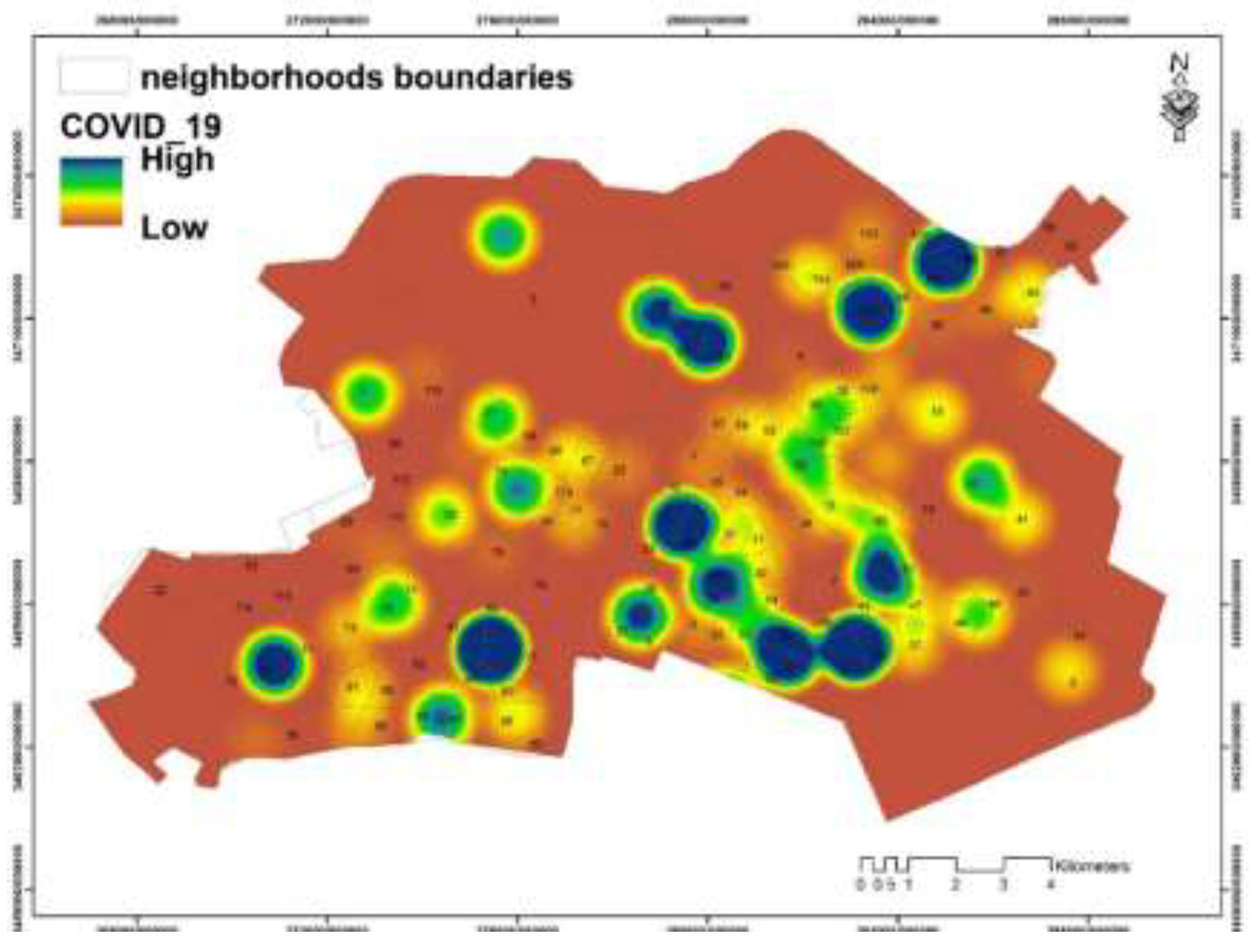
Figure 3.
Different procedures taken in this study.
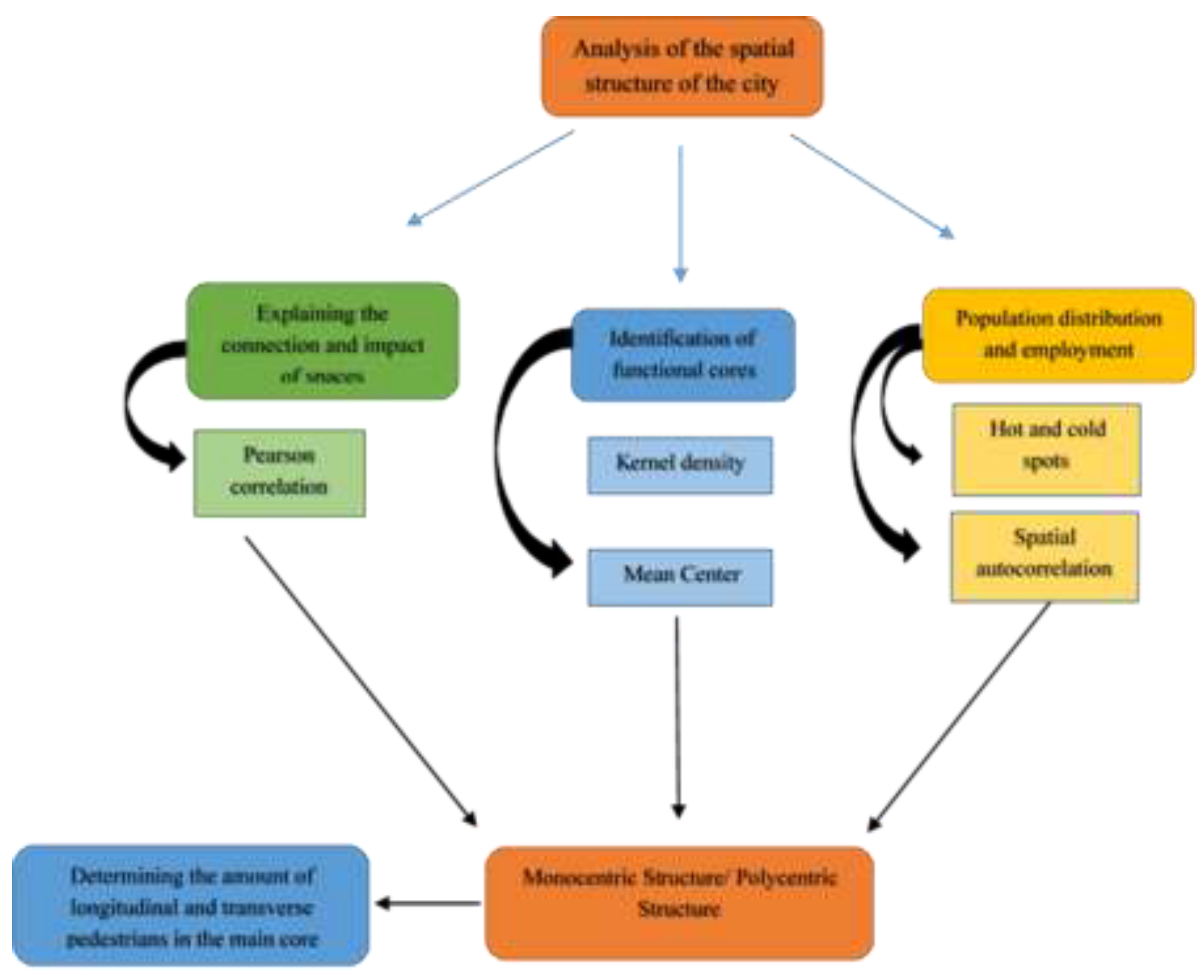
Figure 4.
Population hot- and cold-spots in Ahvaz.
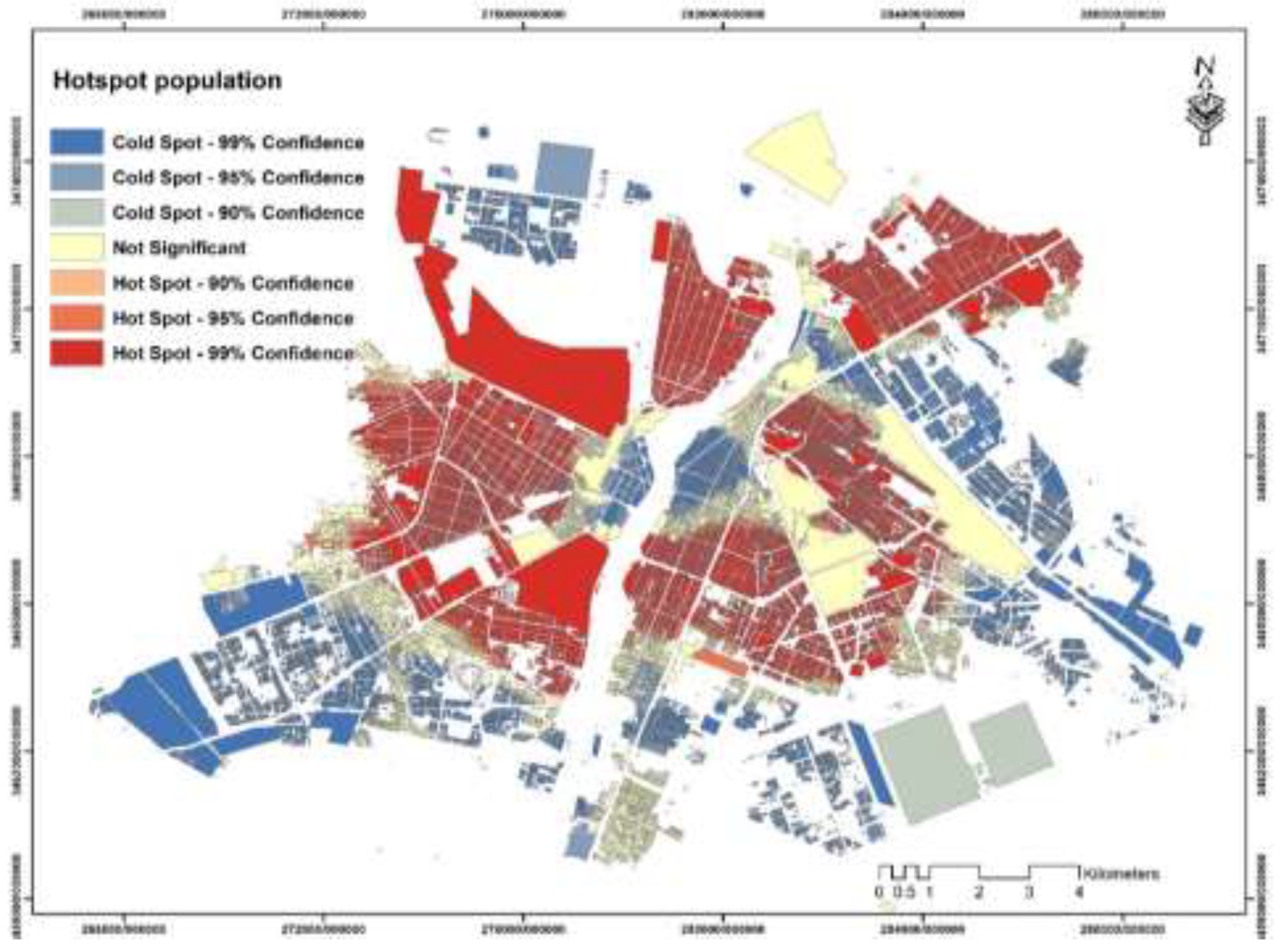
Figure 5.
The location of hot and cold spots of employment distribution in Ahvaz
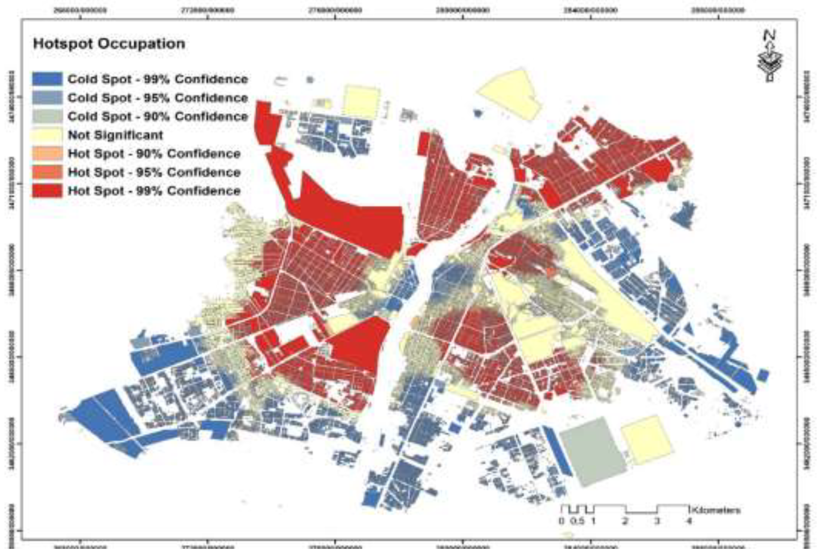
Figure 6.
Different functional cores in Ahvaz.
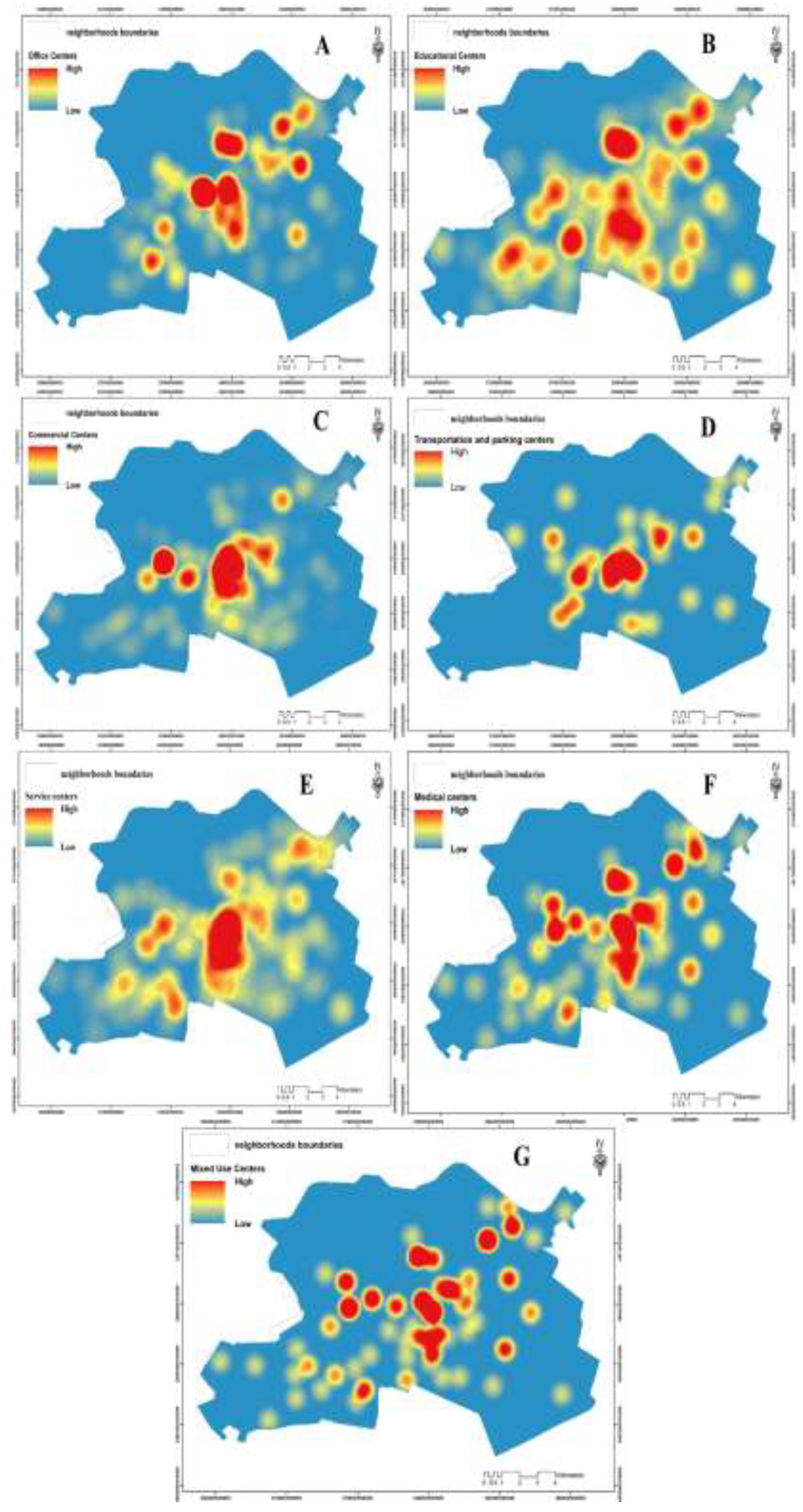
Figure 7.
Distribution of functional cores in Ahvaz.
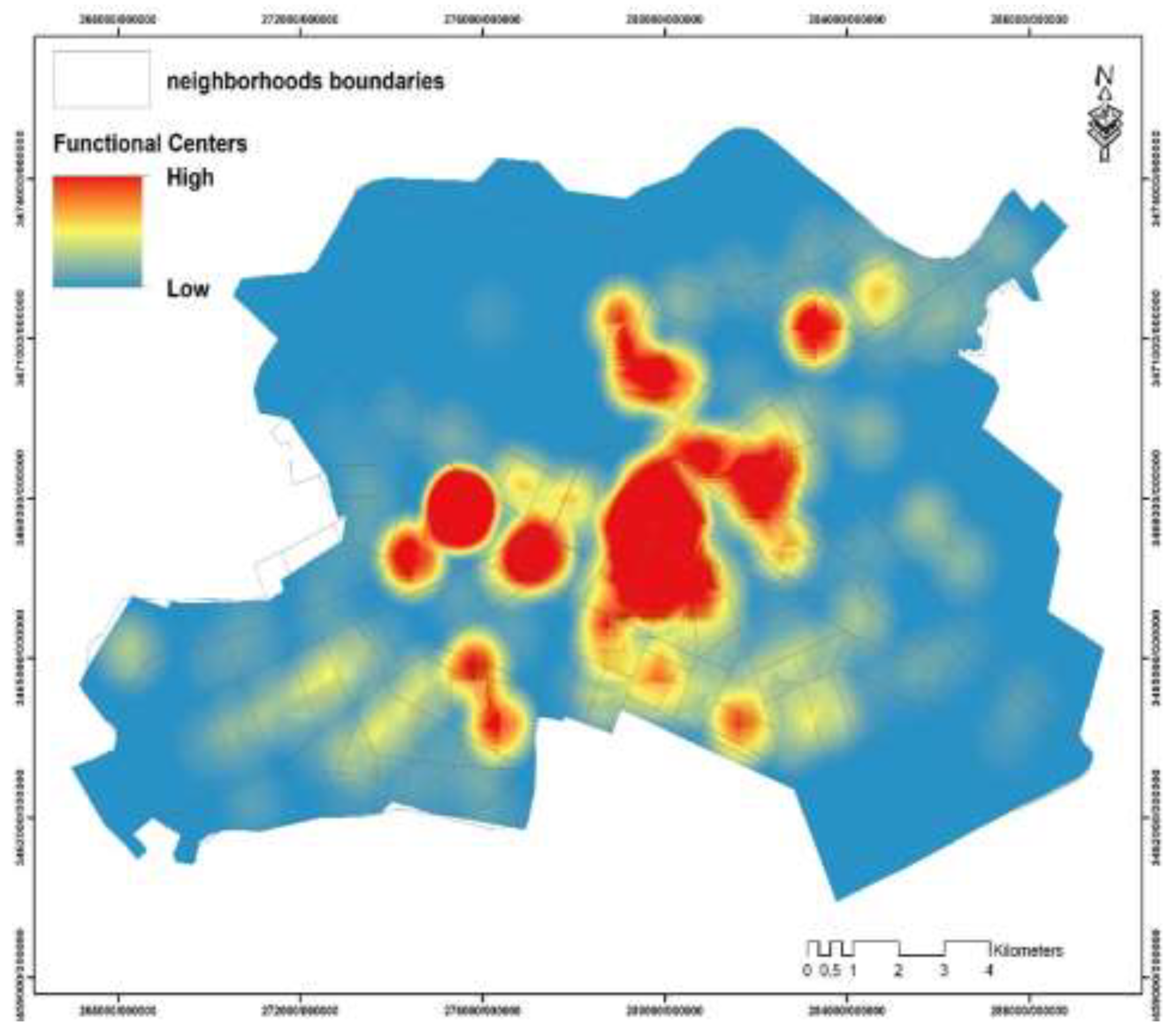
Figure 8.
The central Mean of functional cores in Ahvaz.
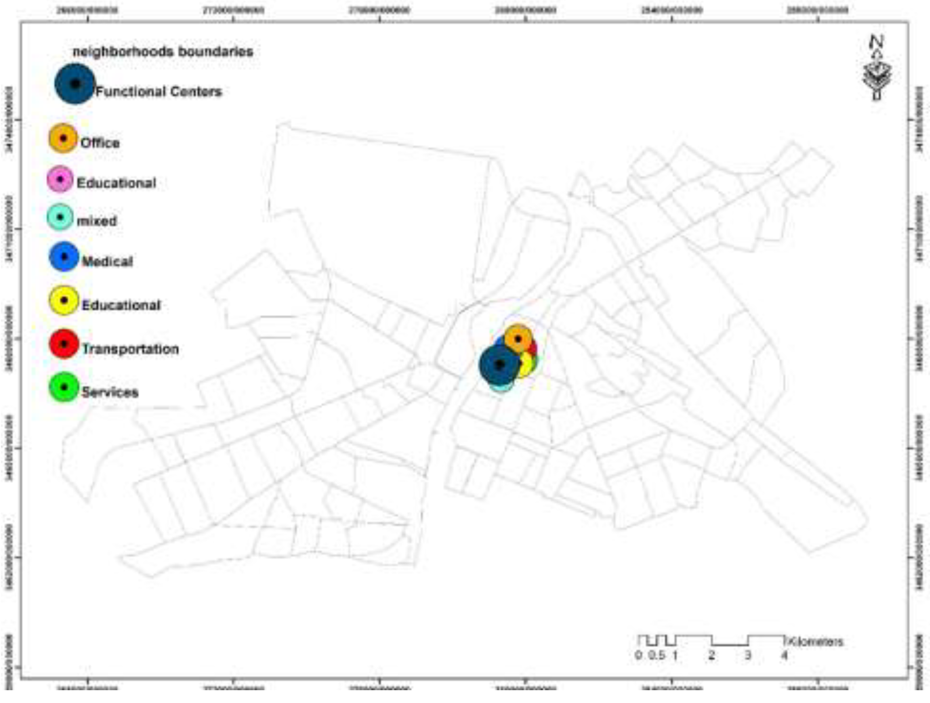
Figure 9.
The number of pedestrians crossing the main sections of the city center during the 15-minute peak (19:30 to 19:45).
Figure 9.
The number of pedestrians crossing the main sections of the city center during the 15-minute peak (19:30 to 19:45).
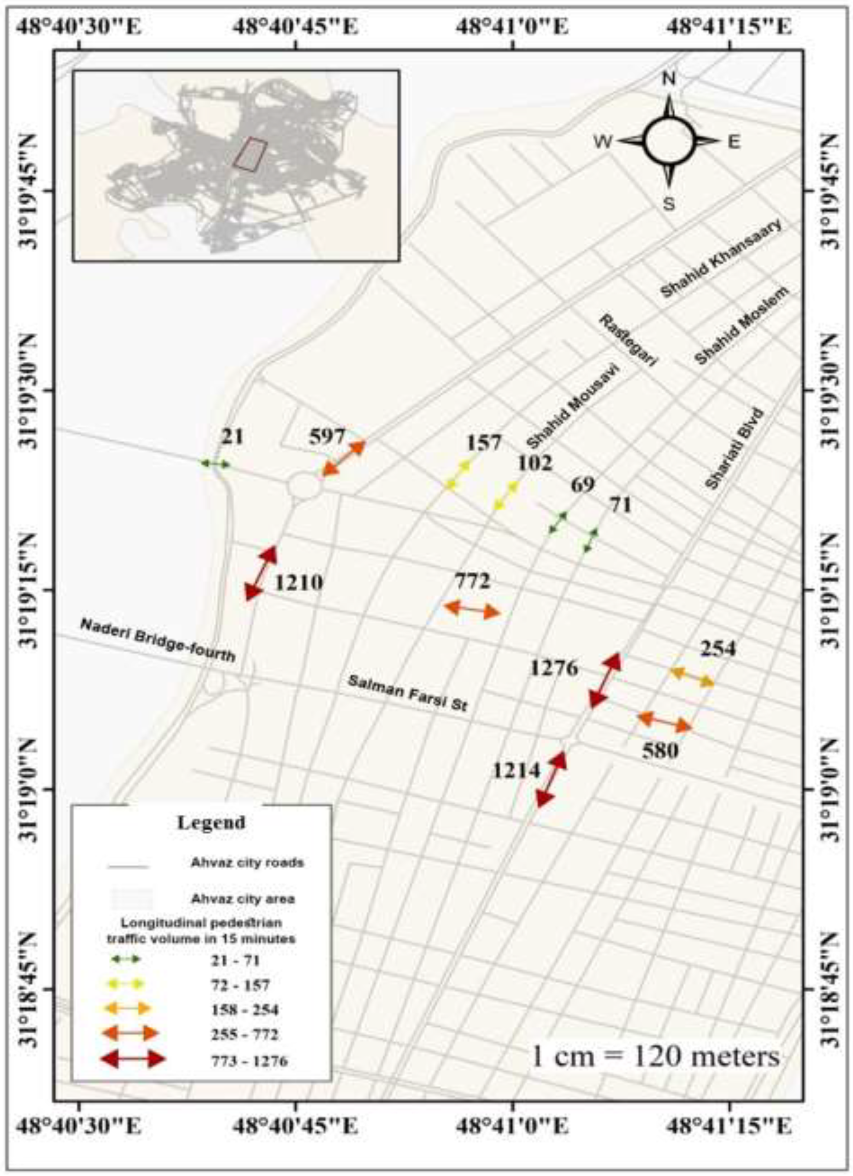
Figure 10.
COVID-19 restrictions in the Ahvaz’s city center.
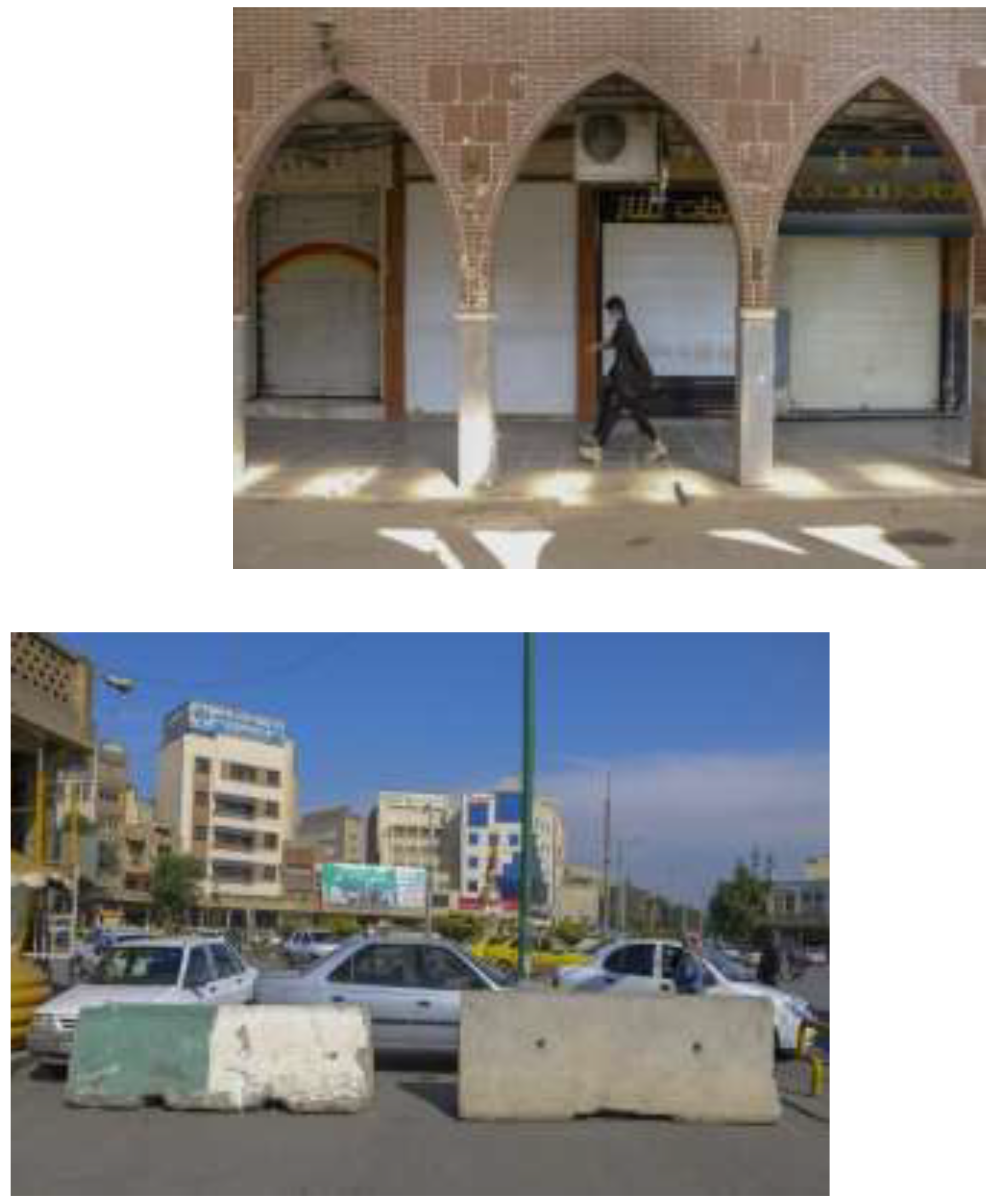
Figure 11.
The number of longitudinal pedestrian traffic crossing during the whole day.
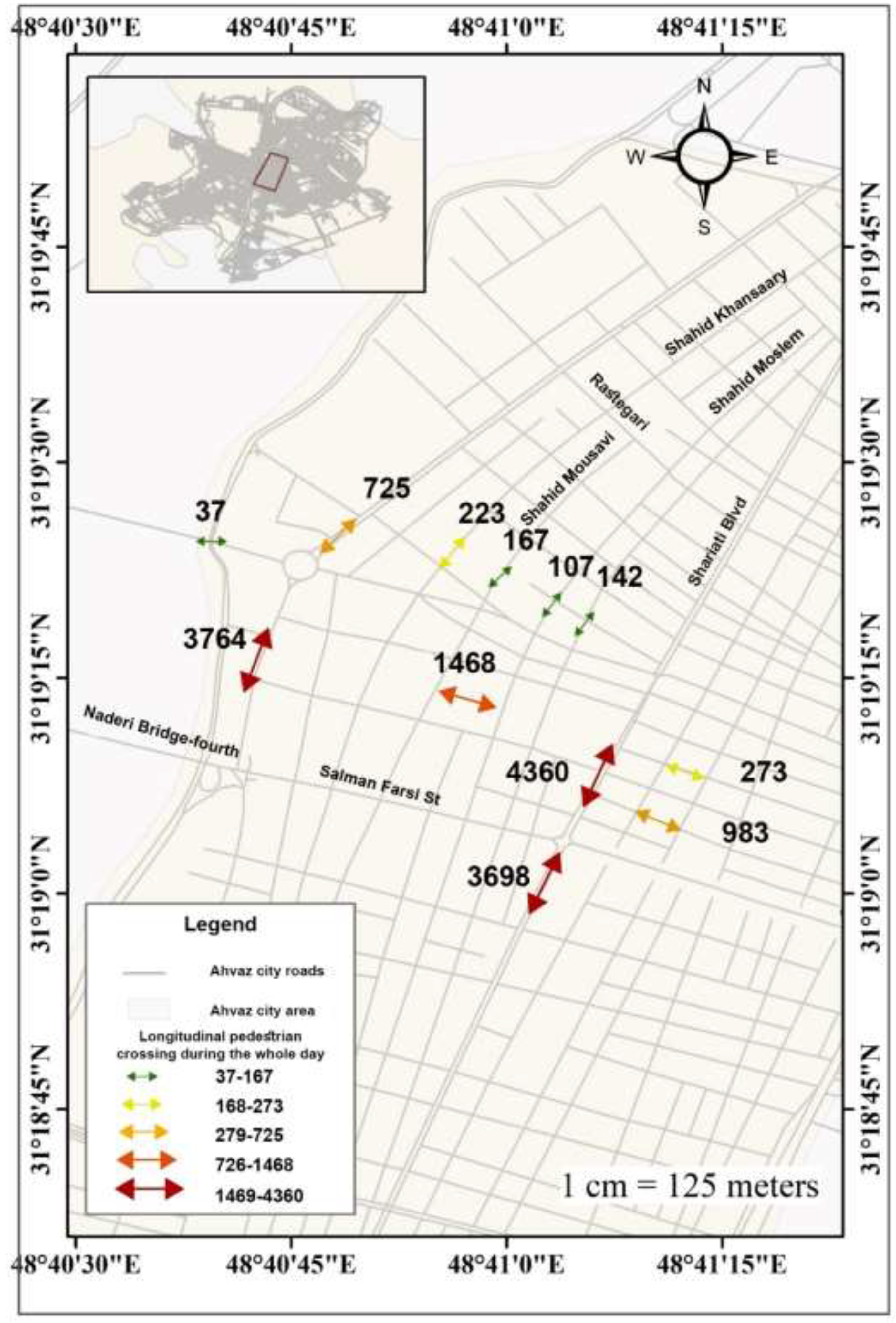
Figure 12.
The number of transverse pedestrian traffic crossing during the whole day.
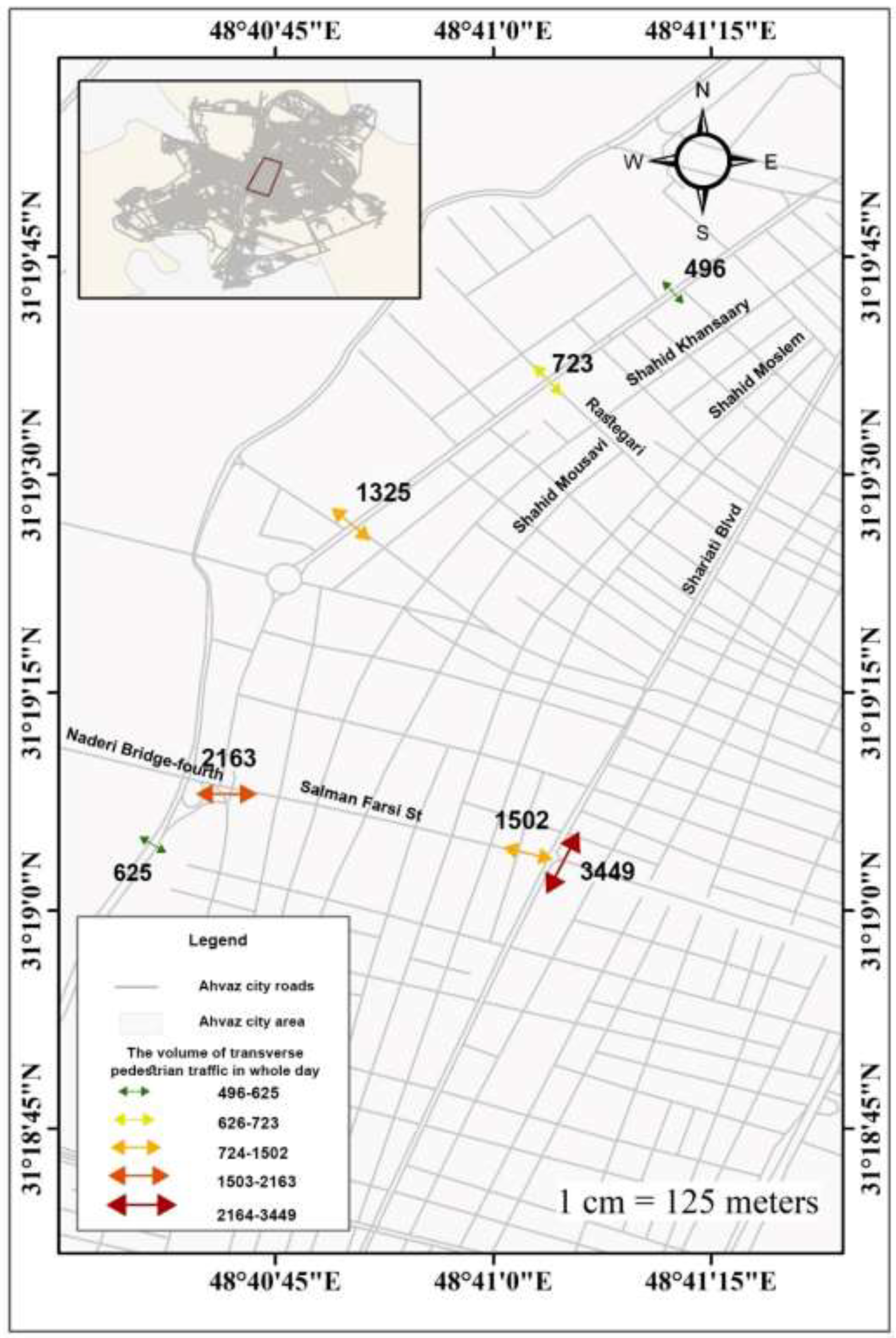

Table 1.
Functional cores in Ahvaz.
| Core | Neighborhood | Map (Figure 8) |
|---|---|---|
| Administrative cores | Amaniyeh, Kianpars,Bagh Moein, Zeyton Karmandi, Shahrak Naft | A |
| Educational core | Shahid Chamran University, Kianpars | B |
| Business cores | The neighborhoods in the central region of the city are Bagh Moein, 30 Metri, Abdul Hamid Bazar, Bagh Sheikh, Saebin Mandaei | C |
| Transportation core | The neighborhoods in the central region of the city are 30 Metri, Bagh Moein, Abdul Hamid Bazar | D |
| Service core | Neighborhoods such as Bagh Moein, 30 Metri, Abdul Hamid Bazar, Bagh Sheikh, Saebin | E |
| Therapeutic core | The neighborhoods in the central region of the city are Bagh Moein, 30 Metri, Abdul Hamid Bazar, Bagh Sheikh, Saebin Mandaei, Zeyton Karmandi, Southern Kampolo, Kianpars | F |
| Mixed core | Neighborhoods such as Bagh Moein, 30 Metri, Abdul Hamid Bazar, Bagh Sheikh, Saebin Mandaei, Zeyton Karmandi, Southern Kampolo, Kianpars | G |
Table 2.
The influence ratio of localities in functional cores.
| Rank | Name | Ratio | Rank | Name | Ratio | Rank | Name | Ratio |
|---|---|---|---|---|---|---|---|---|
| 1 | Southern Kampolo | 0.110232 | 41 | Pareh 60 | 0.007367 | 81 | Sayyahi | 0.001023 |
| 2 | 30 Metri | 0.045771 | 42 | Malashie | 0.007367 | 82 | Karoun | 0.001023 |
| 3 | Abdul Hamid Bazar | 0.045020 | 43 | Kooye Folad | 0.006958 | 83 | Nabovvat | 0.001023 |
| 4 | Lashkar Abad | 0.042224 | 44 | Padad Shahr Phase 1 | 0.006889 | 84 | Javaheri | 0.000955 |
| 5 | Bagh Sheikh | 0.039700 | 45 | Farhang shahr | 0.006889 | 85 | Zoovieh 2 | 0.000955 |
| 6 | Bagh Moein | 0.039018 | 46 | Banafsheh | 0.006685 | 86 | Pastorizeh | 0.000750 |
| 7 | Zeyton Karmandi | 0.35266 | 47 | Janbazan | 0.006685 | 87 | Shahrak-Razmandegan | 0.000750 |
| 8 | Kooye- Alavi | 0.33697 | 48 | Sepidar | 0.006685 | 88 | Manabe-tabiee | 0.000750 |
| 9 | Yousefi | 0.027353 | 49 | Manazel-15-Khordad | 0.006412 | 89 | Nezam-mohandesi | 0.000750 |
| 10 | Hasirabad | 0.025034 | 50 | Pardis 1 | 0.006344 | 90 | Kourosh Phase 4 | 0.000682 |
| 11 | Asiabad | 0.024216 | 51 | Kooye Payam | 0.006344 | 91 | Zargan | 0.000614 |
| 12 | 20 Metri Shahrdari | 0.021282 | 52 | Jahad | 0.005184 | 92 | Kooye Silou | 0.000614 |
| 13 | Kooye Dolat | 0.020941 | 53 | Seyed Khalaf | 0.004843 | 93 | Shahrak Bargh | 0.000546 |
| 14 | Rofaysh Abad | 0.019372 | 54 | Aghajari | 0.004775 | 94 | Kooye 22 Bahman | 0.000546 |
| 15 | Manba-ab | 0.019168 | 55 | Pardis 2 | 0.004707 | 95 | Padad Shahr Phase 5 | 0.000477 |
| 16 | Saebin Mandaei | 0.017599 | 56 | Shahrak Naft | 0.004707 | 96 | Behzad shahr | 0.000409 |
| 17 | Ameri | 0.016098 | 57 | Zoovieh 1 | 0.004638 | 97 | Choneybe-Olya | 0.000409 |
| 18 | Khorosiyeh | 0.015280 | 58 | Ahan Afshar | 0.003752 | 98 | West Resalat | 0.000409 |
| 19 | Azad shahr | 0.014393 | 59 | Manazel Mokhaberat | 0.003615 | 99 | Shahrak Payam | 0.000409 |
| 20 | Kourosh phase 1 & 2 | 0.014461 | 60 | Kooye Farhangian | 0.003547 | 100 | Shahid Chamran University | 0.000341 |
| 21 | Western Kianpars | 0.013799 | 61 | Soltan Manesh | 0.003206 | 101 | Kerishan | 0.000341 |
| 22 | Akhar-asfalt | 0.013165 | 62 | Kourosh Phase 3 | 0.003206 | 102 | Manazel Shahrdari | 000273/0 |
| 23 | Salem Lashkar | 0.012619 | 63 | Mohajerin | 0.003206 | 103 | Baharestan | 0.000136 |
| 24 | Amaniyeh | 64 | Golestan | 0.003138 | 104 | East Resalat | 0.000136 | |
| 25 | Khaz Aliyeh | 0.0111392 | 65 | Kooye Police | 0.002865 | 105 | Sadat | 0.000136 |
| 26 | Kooye Taleghani | 0.010914 | 66 | Kooye Tollab | 0.002797 | 106 | Moein Zadeh | 0.000136 |
| 27 | Shahrake-e-Daneshgah | 0.010368 | 67 | Kooye Moallem | 0.002797 | 107 | Manazel Rahahan | 0.000136 |
| 28 | Padad Shahr Phase 2 | 0.010095 | 68 | Mojahed | 0.002592 | 108 | Kianshahr | 0.000068 |
| 29 | Bahonar | 0.009686 | 69 | Chaharsad-dastgah | 0.002183 | 109 | Golbahra | 0.000068 |
| 30 | Ziba shahr | 0.009686 | 70 | Kooye Abozar | 0.002115 | 110 | Elahiyeh | 0.000000 |
| 31 | Zeyton Kargari | 0.009618 | 71 | Niou-Sayd | 0.001910 | 111 | Boostan | 0.000000 |
| 32 | Southern Golestan | 0.009550 | 72 | Salim Abad | 0.001842 | 112 | Pardis 3 | 0.000000 |
| 33 | Saadi | 0.009482 | 73 | Manazel Janbazan | 0.001842 | 113 | Teraktor Sazi | 0.000000 |
| 34 | Padad Shahr | 0.009141 | 74 | Rah-tarabari | 0.001705 | 114 | Zaferaniyeh | 0.000000 |
| 35 | Northern Golestan | 0.009072 | 75 | Northern Kampolo | 0.001501 | 115 | Kooye Emam | 0.000000 |
| 36 | Kian Abad | 0.008527 | 76 | Meli Rah | 001501/0 | 116 | Mandali | 0.000000 |
| 37 | Kooye Taleghani | 0.007913 | 77 | Goldasht | 0.001364 | |||
| 38 | Shahrvand | 0.007708 | 78 | Manazel Folad | 0.001364 | |||
| 39 | Eastern Kianpars | 0.007708 | 79 | Kooye Ramezan | 0.001296 | |||
| 40 | Kooye-isar | 0.007503 | 80 | Al-taher | 0.001228 | |||
Table 3.
Pearson test results.
| Indicator | Statistics | Population Density | Distance from the city center | Number of employees |
|---|---|---|---|---|
| Functional cores | Pearson Correlation | 0.403** | -0.432** | 0.585** |
| Sig. (2-tailed) | 0.000 | 0.000 | 0.000 |
Disclaimer/Publisher’s Note: The statements, opinions and data contained in all publications are solely those of the individual author(s) and contributor(s) and not of MDPI and/or the editor(s). MDPI and/or the editor(s) disclaim responsibility for any injury to people or property resulting from any ideas, methods, instructions or products referred to in the content. |
© 2025 by the authors. Licensee MDPI, Basel, Switzerland. This article is an open access article distributed under the terms and conditions of the Creative Commons Attribution (CC BY) license (http://creativecommons.org/licenses/by/4.0/).
Copyright: This open access article is published under a Creative Commons CC BY 4.0 license, which permit the free download, distribution, and reuse, provided that the author and preprint are cited in any reuse.


