Submitted:
24 January 2025
Posted:
24 January 2025
You are already at the latest version
Abstract
This article analyzes the impact of urbanization and industrialization on biodiversity and ecosystems, with special attention to habitat fragmentation and loss of ecological connectivity. The methodology includes a comprehensive literature review and a case study in a specific city to evaluate the effects of these urban transformations. Qualitative and quantitative methods were used to develop and validate innovative sustainability indicators designed to measure the health of urban ecosystems and their ability to support biodiversity. These indicators, a key contribution of the study, offer practical and adaptable tools for urban planners and policy makers, facilitating the assessment of ecological connectivity and sustainability. The findings reveal that conserving urban ecosystem fragments improves ecological resilience, mitigates heat island effects, reduces pollution, and fosters long-term sustainability. Furthermore, the article proposes new conservation strategies, integrating these fragments into urban planning, which contributes to the creation of more livable and sustainable cities, with direct benefits for both ecosystems and human well-being.
Keywords:
Sustainability Indicators
; Urban Ecosystems
; Ecological Connectivity
; Sustainable Urbanization
; Biodiversity Conservation
1. Introduction
Accelerated urbanization and industrialization have generated profound transformations in urban ecosystems, resulting in the fragmentation of habitats and decreased ecological connectivity. These effects have severely affected urban biodiversity, reducing the functionality of ecosystems and compromising the resilience of cities to extreme environmental events. In the literature, several studies have highlighted the importance of developing sustainability indicators that measure the impact of urbanization on biodiversity and the health of urban ecosystems.
Numerous studies have documented biodiversity loss in urban areas, highlighting that habitat fragmentation is one of the main drivers of this loss. The construction of infrastructure, such as roads and buildings, disrupts biological corridors and limits the mobility of species, diminishing their ability to access vital resources and maintain their genetic diversity. This phenomenon is particularly worrying in urban areas, where natural ecosystems have been replaced by built-up areas.
At the global level, various indicators have been developed to measure the health of urban ecosystems. Among the most widely used are the fragmentation index, which measures the extent of fragmented habitats compared to the original habitat, and the ecological connectivity index, which assesses the ability of ecosystems to interconnect through ecological corridors. These indicators are based on quantitative and qualitative approaches that incorporate spatial data, biodiversity analysis, and monitoring of ecosystem services.
Several studies have also proposed approaches to assess water quality, biodiversity, and the ability of urban ecosystems to mitigate effects such as increased heat islands and air pollution. However, the practical application of these indicators in urban contexts remains a challenge due to the lack of accurate data and the difficulties inherent in designing public policies that integrate these indicators into urban planning.
One of the main challenges in the implementation of these indicators is the lack of homogeneous and up-to-date data at the local level, which makes it difficult to compare and make informed decisions. Despite this, several studies have identified key opportunities, such as the use of geographic information systems (GIS) and the integration of biodiversity and land use data to create predictive models that aid in the planning of urban ecosystem conservation and restoration strategies.
This article focuses on the development of sustainability indicators to assess biodiversity and ecological connectivity in the metropolitan region of Veracruz. The findings of the literature review have informed the selection of the indicators used in this study, specifically the fragmentation index and the ecological connectivity index. In addition, the challenges and opportunities described in previous studies have helped guide the applied methodology, which includes the use of GIS to analyze ecological connectivity in an urban context. This approach allows for a detailed evaluation of how proposed interventions, such as the creation of ecological corridors, can improve the resilience of urban ecosystems in Veracruz. Figure 1 shows the different variables to be considered for the comprehensive management of urban biological corridors.
2. Materials and Methods
2.1. Study Area
The selected study area is the city of Veracruz, Mexico, characterized by its coastal location and a system of dunes and interdune lagoons. These areas are of high ecological relevance and provide essential ecosystem services such as climate regulation, water purification, and flood control. However, urban and industrial expansion has fragmented these ecosystems, compromising their connectivity and functionality. This environment represents an ideal case for analyzing the relationship between urbanization, biodiversity, and sustainability.
2.2. Logical Framework
The research is based on an interdisciplinary and multi-scalar framework that combines ecological, urban, and social analyses. This approach makes it possible to address the challenges of conservation in urban areas, integrating spatial analysis tools, indicator development, and community participation. Key steps in the logical framework include:
Identification of the problem: Fragmentation of ecosystems in urban environments.
Literature review: Previous studies on the impacts of urbanization on biodiversity and ecological connectivity strategies.
Selection of specific methods: Design of a multi-scale approach to assess fragmentation, connectivity, and sustainability.
Worldwide, coastal areas represent an important flow of commercial or tourist exchange activity. Historically represents connection points between continents and gateways to them, creating a mix of civilizations, culture, ideology, religion, and customs, very similar to the coastal cities of the American continent, marked by the arrival of the Spanish to this continent. The global expansion, the growth of the port, internal migration, and the development of the city did not go unnoticed in the port of Veracruz, in which the city has expanded into 5 municipalities (Veracruz-Boca del Río, Medellín, Paso del Toro and Alvarado), becoming an extensive city that generates greater energy consumption, produces a greater amount of garbage, faces road problems and demand for services, thereby also losing the essence of its identity. In addition to this, climate changes have impacted the population, generating floods, and heat islands, among others.
Socio-economic, climate, and governance factors in urban planning
Impact of urban growth on environmental sustainability
The expansion of the urban footprint and the increase in population in Veracruz have generated significant imbalances in environmental sustainability. Factors such as disorderly growth, high population density, and the conversion of natural areas to urban areas have intensified environmental risks, such as flooding and increased heat islands.
Vulnerability to natural phenomena and climate change
Climate change has exacerbated Veracruz's exposure to extreme events such as hurricanes, floods, and heat waves. The lack of adaptation measures in urban planning increases the vulnerability of local communities, putting both ecosystems and infrastructure at risk.
Challenges in natural resource management
The management of natural resources, including water and soil, is marked by limited coordination between local, state, and federal authorities. The lack of integrated governance generates problems such as the overexploitation of resources, pollution, and the degradation of critical ecosystems [2].
Disconnection in public policies
Policies related to urban development and ecosystem conservation have misaligned goals and strategies. The lack of integration between national and local plans limits the effectiveness of interventions in urban sustainability and resilience.
Role of the community in conservation and governance
The participation of local communities is key to promoting urban sustainability. However, factors such as apathy and limited environmental education make it difficult to implement ecosystem conservation and restoration projects in the region. [3]
The MuSIASEM methodology is a tool through which the relationship between human societies and the environment is analyzed, represented, and characterized, taking into account the complexity of the fabric between its multiple levels and dimensions through a recursive and synthetic language, and flexible with relevance and operationality. In various scenarios and situations [4]. Relating different scales through semantic categories and formal categories, representing each of them [4].
Starting from a generalized approach based on the characteristics or attributes of the objective of interest to be analyzed, allowing a quantitative analysis through the iterative selection process confirming the representative relevance according to the proposed objectives. Integrating to comply with this process, the background and flow model proposed by [5], is adopted, which allows the socioeconomic processes of consumption and production to be represented in biophysical terms. [6]
In addition to the aforementioned, the MuSIASEM methodology allows us to represent functional relationships between the systems that make up a set of subsystems through the management of levels since they have a double nature: that of being part of a system and that of being a complete system as such; since they start from their organization and at the same time generate emergent properties, being part of and necessary for the organization of a larger system. With this, taking finds the relationship between systems and the environment, since they need a continuous contribution of materials and energy to cover the wear and tear of the organizational processes, continuing as a metabolism of system ordering.
The MuSIASEM tool also adds categories relating to them, depending on the needs of the research, which is why it is called semantically open.
In conclusion, the methodology allows to graphically synthesize all the existing interrelationships between the variables, which seeks to evaluate the effects on the urban and natural environment.
2.3. Specific Research Methods
2.3.1. Literature Review
A systematic review was carried out in scientific databases such as Scopus and Web of Science, selecting studies on the effects of urbanization on biodiversity, ecological connectivity, and ecosystem services [7].
Description of the Case Study: Ecosystem Fragmentation in the Metropolitan Region of São Paulo, Brazil
To illustrate the fragmentation of ecosystems in an urban area, the case study of urban development in the metropolitan region of São Paulo, Brazil was selected. This case highlights several key aspects:
Context: The region has experienced rapid urban growth and industrial expansion in recent decades, transforming natural landscapes into extensive urbanized areas. This expansion has resulted in the fragmentation of natural habitats, creating gaps in protected areas that are surrounded by industrial developments, which accentuates the segregation of the natural environment.
- Impacts: Urbanization has led to the fragmentation of local ecosystems, affecting biological connectivity and native biodiversity. The proximity of agricultural activities in these areas contributes to climate regulation, but fragmentation hinders essential ecological processes.
- Data and Evidence: Environmental monitoring studies and spatial analysis show the reduction of green areas and the loss of biodiversity associated with urban sprawl. The existence of homes occasionally occupied by floating populations has led to economic stagnation in the area, exacerbating the environmental crisis.
- Implications: The discussion on the implications for conservation and sustainable urban planning highlights the need for policies that promote the integration of green infrastructure and ecological restoration. It is essential to promote institutionality in urban planning and governance to integrate fragmented areas and mitigate negative impacts.
This case study provides a concrete example of how urbanization can lead to ecosystem fragmentation in an urban environment, exemplifying the concepts discussed in the literature reviewed and the analysis methods used to understand these phenomena.
Analysis of the Case Study: Ecosystem Fragmentation in the Metropolitan Region of São Paulo, Brazil
Context
The metropolitan region of São Paulo has experienced rapid urban growth and industrial expansion in recent decades. This development has significantly transformed natural landscapes into extensive urbanized areas, resulting in the fragmentation of habitats that previously predominated in the environment.
Impacts
Intensive urbanization has led to the fragmentation of local ecosystems, manifesting itself in the division and reduction of natural habitats due to the construction of urban infrastructure such as roads and industrial zones. This landscape alteration has disrupted biological connectivity, affecting species' ability to move, feed, and reproduce. Disorderly urbanization has caused a significant loss of native biodiversity, with many plant and animal species seeing their populations reduced or disappearing locally due to the destruction of their habitats.
Data and Evidence
Environmental monitoring studies and spatial analysis have provided concrete evidence of these impacts. Satellite data and geospatial analyses document the decline of green areas and the fragmentation of natural landscapes. Furthermore, biodiversity studies have recorded the gradual loss of native species and the proliferation of species adapted to urban environments, indicating significant changes in the composition and structure of local biological communities.
Implications
The implications of ecosystem fragmentation in São Paulo are profound and encompass various areas of conservation and sustainable urban planning. It is crucial to implement policies that promote the integration of green infrastructure into the existing urban fabric. This includes the creation of ecological corridors and the restoration of natural habitats within the city to improve biological connectivity. In addition, it is necessary to adopt urban planning practices that mitigate adverse environmental impacts, promoting more sustainable development that balances the needs of urban growth with the conservation of biodiversity and ecosystem services.
Table 1 concisely summarizes the main aspects of the São Paulo case study, highlighting how urbanization has fragmented urban ecosystems and the implications for conservation and sustainable urban planning.
The São Paulo case study clearly illustrates how uncontrolled urbanization can fragment and degrade urban ecosystems, negatively affecting biodiversity and ecological functionality. This example not only exemplifies the concepts discussed in the reviewed literature on the effects of urbanization on biodiversity but also highlights the importance of applying spatial analysis and environmental monitoring methods to understand and address these phenomena effectively in urban contexts.
Literature Review
Urbanization and industrialization have been widely studied due to their profound and, in some contexts, negative effects on biodiversity. Urban sprawl involves the conversion of natural habitats into urban infrastructure, which reduces the areas available for wildlife and fragments ecosystems. [8]. This process of habitat fragmentation is one of the main factors contributing to the loss of biodiversity. Fragmented ecosystems not only decrease in size but also become less connected, limiting species movement and genetic dispersal.
Furthermore, pollution is another significant adverse effect of urbanization and industrialization. Air, water, and soil pollution can have lethal and sublethal impacts on local species, altering population dynamics and ecological processes. [9]. For example, light and noise pollution in cities can affect wildlife behavior patterns, such as migration and reproduction.
Changes in land use and infrastructure construction can also alter the local microclimate, creating urban heat islands that can affect both flora and fauna. These changes in environmental conditions can favor invasive species that compete with native species, further exacerbating the loss of biodiversity. [10].
Identification of Gaps and Controversies in Existing Literature
Despite abundant research on the effects of urbanization and industrialization, there are several gaps and controversies in the literature. Table 2 summarizes the main themes discussed in the literature, along with references.
Relationship of the Reviewed Literature with the Selected Case Study
The case study selected in this article focuses on a specific urban area that has experienced rapid industrial expansion and development. Reviewing the existing literature, it is noted that many of the documented problems, such as habitat fragmentation, loss of biodiversity, and pollution, are evident in the case study. This context allows the findings of previous studies to be applied to evaluate the current situation and develop specific conservation strategies for the area in question.
Additionally, the case study provides an opportunity to address some of the gaps identified in the literature. For example, changes in biodiversity and ecosystems can be tracked longitudinally, using methods such as environmental monitoring and spatial analysis. Both direct and indirect impacts of urbanization and industrialization can also be assessed. Likewise, different urban conservation strategies, such as the implementation of green infrastructure, can be tested and their effectiveness evaluated, thus contributing to the discussion on best practices for sustainability in urban areas.
The expansion of cities has significantly influenced biodiversity in multiple regions. Previous studies have shown that the expansion of cities and the growing demand for road and rail infrastructure have caused a breakdown of territory, fragmented ecosystems, and decreased biological connectivity. This has led to a loss of biodiversity and a decline in the ecological functionality of ecosystems, which in turn negatively affects the social and economic well-being of urban communities.
It is considered that in areas whose vegetation loss is less than 40%, only populations of species that require a specific habitat will be affected. Therefore, it is important to integrate ecosystem fragments already adapted into urban environments.[12]
Previous Actions and Recent Advances
There are examples of successful projects and recent advances in the conservation of urban ecosystems and the implementation of ecological corridors. For example, the study by [13] Defines ecological corridors as "strips of vegetation incorporated into the landscape that influence ecological processes and provide a variety of goods and services” and highlights their importance for conservation. of biodiversity and biological connectivity. An example of this is the María Aguilar River interurban ecological corridor in Costa Rica, integrated into the territorial planning policy within the 2015-2018 Territorial Planning Plan. [14]. On a regional scale, the Mesoamerican Biological Corridor (CBM) was created as a conservation initiative that involved all the countries of Central America and five states in the southeast of Mexico. It would be useful to evaluate the specific results achieved through this collaboration. The first analysis of the present study is shown in Table 3 [15], [16].
On the other hand, it is also necessary to carry out an analysis of the Mesoamerican biological corridor (CBM) in Costa Rica. Table 4 shows and simplifies the analysis of the corridor. From this analysis, the understanding of the case study synthesizes the understanding of the impact generated by it.
Once the analyses of both the María Aguilar River Interurban Ecological Corridor and the Mesoamerican Biological Corridor (CBM) have been developed, it is possible to simplify the information and develop a matrix analysis of both case studies. Table 5 structures the matrix analysis described.
The urban ecological corridor or green corridors
They reduce the temperature of the earth's surface in cities by up to 12°C in summer according to the Institute of Atmospheric and Climate Sciences, ETH Zurich (Switzerland). Trees generate a cooling effect, helping to mitigate global warming and reduce the effects of climate change. This generates sustainable urban areas preserving biodiversity, the structure of ecosystems with the union of natural areas fragmented by the invasion of urban growth [22].
The difference is marked by the World Conservation Fund between ecological corridors, which have a width of 1 to 5 kilometers, and conservation corridors, with a width of less than 1 kilometer.
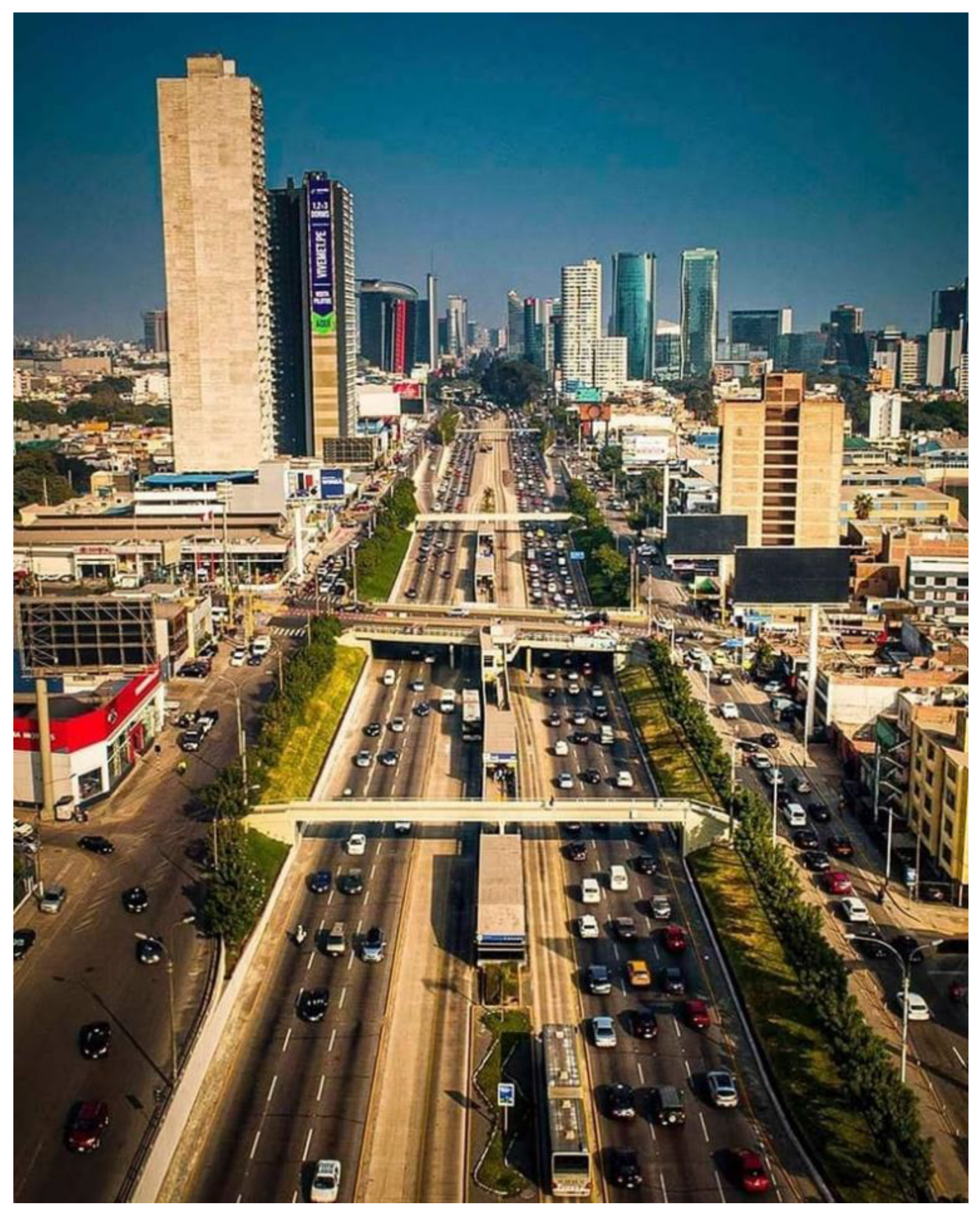
The latter is applied to megalopolises or metropolitan areas, those with a parameter greater than 10 million inhabitants. And through which all natural areas are naturally connected with the urban environment. An example would be the Paseo de la República in Lima.
Advantages of the Urban Ecological Corridor
They increase biodiversity in the urban environment by giving continuity to green spaces, creating islands that mitigate climate change and protect species and ecosystems.
They reduce air pollution and noise pollution, due to the reduction in the use of polluting transport [23].
They promote sustainable mobility, with which we can move around on bicycles or scooters and pedestrian traffic.
As we explained at the beginning, thanks to the cooling power of trees, they prevent the formation of heat islands.
They improve rainwater management, being more effective in regulating vessels by filtering rainwater flow.
They increase people's well-being and connection with nature, encouraging physical activity.
They can become a tourist attraction that positively influences the economy of cities.
Promotion of activities: sports, cultural, recreational, and triggering economic activity.
They provide greater environmental and landscape value for the city and are a factor in increasing value for the surrounding population. [24]
Examples of green and ecological corridors in the world
Madrid Río: Linear park, which goes from El Pardo to Getafe. Spread over 1,210,881 square meters, with 53,550 meters of pedestrian routes and 33,623 new trees of 47 species have been planted. It has train tracks that connect the Atocha and Chamartín stations. Large green areas, with children's games and sports, in which cultural and sporting events are held: concerts, festivals, popular races, etc. [25].
The Manhattan Waterfront Greenway, the longest greenway on the island, runs along the West Side, from Battery Park in the south to Dyckman Street in the north. This ecological corridor promotes activities and integrates the parks of Hudson River Park, Riverside Park, and Fort Washington Park. This ring that surrounds Manhattan will have an extension of 51 km.
Seville Green Corridor. It connects the stations of San Bernardo and Santa Justa, "generating a greener space, with greater tree mass and the planting of new shrubs and herbaceous plants".
Green corridor of Tamaraceite and Ciudad Alta de las Palmas de Gran Canaria. It connects the neighborhoods of Tamaraceite and Ciudad Alta through a natural corridor. Regenerating nine areas of these two urban areas with more than 10,000 specimens between trees and shrubs. This corridor will have an area of about 46 hectares and is expected to be completed by 2025.
Figure 2.
paseo de la República in Lima. Source: Gapa, K. (2020). Paseo de la Republica Lima, Perú. Montaña de 7 Colores, Agencia de Viajes Tour Operador. https://www.facebook.com/photo.php?fbid=3117368538510709&id=1824340997813476&set=a.1827630567484519&locale=it_IT. [26].
Figure 2.
paseo de la República in Lima. Source: Gapa, K. (2020). Paseo de la Republica Lima, Perú. Montaña de 7 Colores, Agencia de Viajes Tour Operador. https://www.facebook.com/photo.php?fbid=3117368538510709&id=1824340997813476&set=a.1827630567484519&locale=it_IT. [26].
These examples successfully describe the implementation of urban corridors that impact from a local level to a regional level, within the same analysis their relevance and importance not only for people but also for the conservation of biodiversity and the promotion of ecological connectivity are highlighted mainly in urban environments.
The analysis literature analysis on the effects of urbanization and industrialization reveals several aspects for understanding their impacts on biodiversity. First, the limited spatial and temporal scale of existing studies makes it difficult to assess long-term effects, underscoring the need for larger and more ongoing research, as suggested by [10]. Furthermore, although direct impacts, such as habitat loss, have been documented, indirect impacts, including pollution and urban climate change, require urgent attention as they are essential for a comprehensive analysis of the problem.
The debate on the adaptation and resilience of urban species also highlights the complexity of ecosystems in urban environments. While some studies suggest that certain species can adapt and thrive, others indicate that they face significant challenges in the face of rapid environmental change. This highlights the importance of understanding the diversity of responses between species and the specific urban context. Regarding urban conservation, although the need to conserve fragments of urban ecosystems is recognized, the most effective strategies, such as the implementation of green infrastructure and ecological restoration, are the subject of debate, requiring more successful case studies that can guide future interventions.
2.3.2. Spatial Analysis
Using Geographic Information Systems (GIS) tools, land cover and habitat fragmentation data were analyzed. This analysis made it possible to identify potential ecological corridors and evaluate the connectivity between fragments of ecosystems, the Figure 3 shows the map of the existing coastline extensions in Mexico based on INEGI data.
Concerning another geographic information system that currently represents a good option and simplifies the visualization, management and obtaining of information, it is Google Heart, an open access software that simplifies its operation. Figure 4 shows the fragmentation of water bodies in Veracruz, Mexico.
2.3.3. Interviews and Qualitative Analysis
Semi-structured interviews were conducted with experts in ecology, urban planning, and natural resource management, as well as with local actors. These interviews complemented the quantitative data and allowed a deeper understanding of the challenges and opportunities in the conservation of urban ecosystems, the application of the multiple-choice questionnaire applying questions related to the social and economic characteristics of the population.
2.4. Application of the Method
The application of the method was developed considering an interdisciplinary and multi-scale approach that combines spatial analysis, sustainability indicators, and community participation. A detailed study was carried out in the selected area of Veracruz, Mexico, to assess ecosystem fragmentation and design strategies to conserve biodiversity and improve ecological connectivity.
Multiscalar Analysis Methods
The Multi-Scalar Integrated Analysis of Social and Ecosystem Metabolism (MuSIASEM) Method is a useful tool to address the complexity of urban systems. This method allows the integration of qualitative information generated by various conventional models based on different scales and levels of analysis, considering multiple urban, architectural, technological, landscape, and ecological paradigms. In western Ecuador in the province of Manabí, a Geographic Information System was used for the assessment and cartographic representation of the study, resulting in a map for each of the variables considered.
To comprehensively understand the effects of urbanization and industrialization on biodiversity and urban ecosystems, it is essential to adopt a multi-scalar approach. This method allows phenomena to be analyzed at different spatial and temporal scales, providing a more complete view of the impacts and facilitating the development of conservation and sustainability strategies adapted to specific contexts. [29] Develops the method in an appropriate and relevant manner, Figure 5 shows graphically and textually the implementation of the multi-scalar method.
Description of the Method
Multiscale analysis in this context involves the study of the effects of urbanization and industrialization on biodiversity and ecosystems at various scales: local, regional, and global. Each scale offers a unique and complementary perspective on ecological processes and conservation challenges.
- Local Scale: At the city or neighborhood level, changes in species composition, habitat fragmentation, and direct impacts of urban infrastructure are examined. This level of analysis is crucial to understanding how local development and planning practices affect biodiversity and ecological functionality.
- Regional Scale: At the regional level, the approach is expanded to consider the connectivity between different natural and urban areas. It analyzes how urban expansion affects ecological corridors and the dispersal of species, as well as the interactions between different ecosystems and landscapes. [30]
- Global Scale: At a global level, general urbanization patterns and their impact on global biodiversity are evaluated. This level of analysis is important for identifying global trends and comparing different regions of the world, providing a broader context for local and regional observation challenges.
Application of the Method
Local Scale
In the selected case study, a detailed analysis of the biodiversity and ecosystems within a specific city is carried out. Field data, such as species inventories and land use maps, are used to assess habitat fragmentation and biodiversity loss. Techniques such as GIS (Geographic Information Systems) analysis are used to map and quantify changes in land cover and ecological connectivity.
Example: The fragmentation of an urban park and its impact on the local bird population can be analyzed using bird census data and vegetation cover maps. This analysis can reveal patterns of species decline and suggest conservation measures, such as the creation of green corridors.
The definition of biodiversity refers to “the variety of plants domesticated by man and their wild relatives (agrobiodiversity), the diversity of functional groups in the ecosystem (herbivores, carnivores, parasites, saprophytes, among others), and cultural diversity.” human (customs, languages , and worldviews)” [31]. Indicating thereby the valuation and importance of biodiversity which encompasses biological, economic, and cultural dimensions: ecosystems are reservoirs of irreplaceable genetic information, they provide environmental services that benefit society as a whole, through raw materials (wood, fibers, medicines, water, food, etc.), regulate the climate and control erosion, help with soil formation and nutrient recycling; in addition to being a source of artistic, spiritual and re-creative inspiration, among others [31]. The environmental services that ecosystems provide us are divided into provision or supply, regulation, and cultural and ecological support services. The unprecedented degradation of ecosystems, initiated by urbanization, puts future viability and social sustainability at risk. The Millennium Ecosystem Assessment, requested by the United Nations in 2000, concluded that in the last fifty years, ecosystems have been degraded at a rate and on a scale that has no historical precedents. [32]. This applies to our country, and also to the state of Veracruz. These trends would imply serious consequences for the well-being of the population in general, seriously compromising the future of the country and the state.
Climate
Veracruz is located in the intertropical zone and due to its proximity to the Tropic of Cancer, has a warm subhumid climate.
Geomorphology
The geomorphological regionalization of the state of Veracruz includes 37 units that belong to six of the 14 geomorphological provinces of the country. [33]. The state has an important geodiversity since 57% of all the geomorphological units of the country's mainland are represented in its territory geomorphological units of Veracruz, according to these authors: 1) hills modeled by Quaternary fluvial dissection processes; 2) low plains formed by cumulative processes of the Quaternary, Pliocene-Quaternary, categories are located essentially in the province of the coastal plain of the Gulf of Mexico.
Ground
16 of the 25 soil groups are present in the entity according to the classification of the UN Food and Agriculture Organization (FAO). The soil groups with the largest extension are Vertisol, Feozem, Luvisol, Acrisol, and Andosol, which together occupy 67% of the surface of the state, with Vertisol standing out with 27% presence on the surface of the entity. Veracruz has one of the most important natural strengths in its soils since the good state of natural habitats, agricultural, livestock, forestry, and urban activity depends on its conditions. However, its inappropriate use is having adverse effects on biodiversity, agricultural productivity, and environmental quality. Soil quality degradation processes such as erosion, loss of organic matter, and decreased water retention capacity are associated with environmental deterioration and the low sustainability of many agricultural systems; deforestation, conventional tillage, and livestock management are the main causes. [34]
Hydrology
The National Water Commission divided the country into Hydrological-Administrative Regions, of which two involve Veracruz: region IX Northern Gulf and X Central Gulf. The Water Law of the state of Veracruz recognizes five regions: Bajo Pánuco, North Veracruz, Central Veracruz, Papaloapan, and Coatzacoalcos. [35].
Popal-titular
The popular vegetation type is distributed in coastal freshwater bodies. The popular characterized by Thalia geniculate and the tears of Typha domingensis [4]. The popal-tular is mainly characterized by herbaceous species of monocotyledons. Associated with this ecosystem are various species, from floating ones or those rooted to the bottom to arboreal ones that surround the body of water. Some associated trees are Annona glabra and Ficus insipida subsp. insipida, Ficus obtusifolia, Pachira aquatica, Salix humboldtiana and Sapium macrocarpum. Some typical shrubs are Piper aduncum, Pluchea odorata, and Salix chilensis. The characteristic species of the herbaceous layer are Cyperus articulatus, Echinodorus andrieuxii, Heliconia lati spatha, Nymphaea ampla, Pontederia sagittata, and Sagittaria lan-centifolia [38]. Of the 250 species registered in this type of vegetation, there are approximately seven species that are endemic or in some risk category according to nom-059-smart-2010 [39] And the red list of the International Union for the Conservation of Nature.
Coastal Dunes
The coastal dune vegetation in the state of Veracruz is characterized by a dispersed tree stratum 5 to 10 m high as shown in Figure 6, [40]. The species Attalea butyracea, Bumelia celastrina, Chrysobalanus icaco, Diphysa robinoides, Enterolobium cyclocarpum, Gliricidia sepium, Piscidia piscipula and Pithecellobium lan-ceolatum stand out. Some typical shrubs are Caesalpinia bonduc, Dalbergia brownei, Manihot carthaginensis, Pluchea odorata, Randia aculeata, Schaefferia frutescens, Tecoma stans, and Verbesina persicifolia. Some herbs stand out for their importance in the natural fixation of the dunes, such as Ambrosia artemisiifolia, Asclepias oenotheroides, Cleome viscosa, Heliotropium teratoma, Hydrocotyle bonariensis, Iresine Celosia, Opuntia stricta var. di-llenii, Schizachyrium scoparium var. littorals and Tournefortia hirsutissima [38].
Flora
Invertebrates
Invertebrates, the State Study [43], is made up of 718 families and the presence of 9,551 species, represented by 75% of insects, 9.8% of arachnids, 5% of crustaceans, 3.9% of annelids and the rest among diverse in the case of aquatic invertebrates (marine and freshwater) the information is very scarce in these ecosystems, Table 6 shows climatological data of the studied area described in [43].
Birds
In the skies of Veracruz, autumn marks the beginning of the migration of birds of prey that come from southern Canada and the United States in search of warmer areas on the American continent. For four months, from August to November, eagles, hawks and kites migrate, along with other aquatic birds such as storks, pelicans, pigeons and flycatchers. This migratory phenomenon involves approximately 23 species of birds of prey and more than 700 species of birds and insects, such as dragonflies and butterflies, which cross the region taking advantage of the coastal winds and favorable climate. This is the largest migratory corridor of species worldwide, according to [44], [45] Pronatura Veracruz A.C.
Regional Scale
At the regional level, the connectivity between urban habitat fragments and surrounding natural areas is studied. Landscape connectivity models are used to identify ecological barriers and corridors. The flows of species between urban and rural areas are also analyzed, and how road and rail infrastructure affect these flows. Figure 4 shows graphically the fragmentation of habitats in lagoon areas due to indifference in the application of connectivity models.
Development of Sustainability Indicators
Using multiscale analysis, specific indicators are developed to evaluate the sustainability and health of urban ecosystems. These indicators include:
- Habitat fragmentation indicators: They measure the degree of fragmentation of urban ecosystems and the connectivity between habitat fragments.
- Species diversity indicators: Evaluate the richness and abundance of species in urban areas.
- Ecosystem services indicators: Measure the provision of key ecosystem services, such as climate regulation, air quality and water management.
- Human well-being indicators: They relate the presence of urban nature to the health and well-being of urban communities.
These indicators are used to monitor and improve the ecological sustainability of cities, providing practical tools for urban planners and policy makers. [24]
Multiscale analysis is a powerful tool for understanding the complex impacts of urbanization and industrialization on biodiversity and ecosystems. By applying this approach, this article not only evaluates the effects at different spatial levels, but also provides a solid basis for developing conservation and sustainability strategies adapted to local, regional and global contexts.
Table 7 shows a matrix that develops sustainability indicators in relation to multiscale analysis and its application in the evaluation of the sustainability and health of urban ecosystems:
Application of Multiscalar Analysis
Multiscale analysis allows these indicators to be evaluated at different spatial levels:
Local Scale: Focuses on specific areas within a city to understand how habitat fragmentation, species diversity, ecosystem services and human well-being are affected at a micro level.
Regional Scale: Broadens the focus to compare different cities or urban regions, identifying regional patterns and trends in urban sustainability.
Global Scale: Provides a global perspective on the challenges and opportunities to improve urban sustainability, comparing indicators between cities on different continents and socioeconomic contexts.
This comprehensive approach not only facilitates understanding of the complex impacts of urbanization and industrialization on urban ecosystems, but also provides a solid foundation for developing conservation and sustainability strategies adapted to local, regional and global contexts, Table 8 analyzes the different scales of the method and the different aspects that each of them are related to.
2.4.1. Analysis of the Case Study
The initial analysis of the intervention area included the identification of fragments of natural ecosystems, such as interdune lagoons and coastal vegetation zones. For this purpose, high-resolution satellite images were used, complemented by topographic and land use maps provided by the National Institute of Statistics and Geography (INEGI).
Description of the Case Study
The case study selected for this research focuses on the city of Veracruz, Mexico. This coastal city has experienced rapid population growth and economic development in recent decades, which has generated significant challenges for the environmental and social sustainability of the region.
The geographic and water analysis of the study area revealed that Veracruz is located in a coastal area with a dune system that includes shallow freshwater interdune lagoons, formed by the outcrop of the water table. However, urban growth and industrial activity have fragmented these natural ecosystems, putting biodiversity and the ecosystem services they provide to the population at risk.
Therefore, the purpose of this case study is to analyze in depth the relationship between biodiversity and ecosystems in the urban environment of Veracruz, with the objective of developing sustainability indicators and effective strategies for the conservation and restoration of fragments of remaining ecosystems. This approach will generate practical recommendations so that urban planners and policy makers can make informed decisions that integrate the protection of biodiversity and ecological functionality.
Context and Background of the Selected Urban Area
The case study selected for this research focuses on the city of Veracruz, Mexico. This coastal city has experienced rapid population growth and economic development in recent decades, which has generated significant challenges for the environmental and social sustainability of the region.
The geographic and water analysis of the study area revealed that Veracruz is located in a coastal area with a dune system that includes shallow freshwater interdune lagoons, formed by the outcrop of the water table. However, urban growth and industrial activity have fragmented these natural ecosystems, putting biodiversity and the ecosystem services they provide to the population at risk.
Being a coastal city, Veracruz and its conurbations represent a large number of interdunal lagoons that were integrated into the urban environment, located in greater concentration in areas of popular and irregular settlements that are currently regularized.
Therefore, it is of vital importance to recover those aquifers that are in a process of abandonment and social risk, taking advantage of the natural resource, recovering it, and integrating it as part of social and economic well-being. This would generate recovery, conservation, and less use of this resource.
To achieve the recovery of the natural environments within the city and take advantage of the wealth of aquifers in the area, it is proposed to unite the natural areas fragmented by the expansion of the city through linear ecological corridors. These ecological corridors and greenways are approached from different perspectives of ecological conservation and integration into the environment.
This case study is relevant and significant for research for several reasons:
Importance of Biodiversity and Urban Ecosystems: The conservation of urban ecosystems and biodiversity is fundamental for the well-being of communities and the long-term sustainability of cities. This case allows us to analyze the challenges and opportunities for the conservation of these valuable natural resources.
Integrated and Multi-scalar Approach: The use of the MuSIASEM method allows for addressing the complexity of urban systems and biodiversity from an integrated and multi-scalar perspective, considering social, economic, environmental, and governance factors.
Applicability to Other Urban Contexts: The lessons learned, and strategies developed in this case study may be relevant and applicable to other cities facing similar challenges of ecosystem fragmentation and biodiversity loss.
Potential Impact on Decision Making: The results of this study can inform and guide the decision-making of policy makers and urban planners, to develop and implement effective policies and strategies for biodiversity conservation and promotion. of sustainability in cities.
Methods and Techniques Used in the Analysis of the Case Study
The Veracruz case study offers a rich opportunity to explore how the interactions between urban growth, biodiversity conservation, and social well-being are critical to the sustainable development of biodiversity. Broadening the debate in these directions not only deepens the understanding of the problem, but also offers a broader framework for the development of effective and sustainable solutions in the region. The key findings of this case study in the city of Veracruz have important implications for biodiversity conservation and the promotion of sustainability in urban environments. The result is indicators: 1.- governance, 2.-climate, 3.-social, 4.- ecosystem. [46]
Multi-scale analysis A multi-scale integrated analysis approach was applied using the MuSIASEM (Multi-Scale Integrated Analysis of Societal and Ecosystem Metabolism) methodology. This tool allows the integration of qualitative information generated by various conventional models based on different scales and levels of analysis, considering multiple urban, architectural, technological, landscape and ecological paradigms.
Geographic Information Systems (GIS) GIS analysis techniques were used to map and quantify changes in land cover and ecological connectivity. For example, the fragmentation of urban ecosystems and its impact on the population of species was analyzed using data from biological censuses and vegetation cover maps.
Landscape connectivity models at the regional level, landscape connectivity models were used to identify ecological barriers and corridors, and analyze species flows between urban and rural areas. This allowed us to evaluate how road and rail infrastructure affects the connectivity of ecosystems.
Comparative analysis on a global scale, urbanization patterns and their impacts on biodiversity in different cities around the world were compared. Global databases, such as the Global Biodiversity Database (GBIF), were used to compare biodiversity loss in various urban contexts.
Development of sustainability indicators, using multiscale analysis, based on specific indicators to evaluate the sustainability and health of urban ecosystems. These indicators include measures of habitat fragmentation, connectivity, water quality, air quality, and human well-being.
The combination of these methods and techniques allowed us to obtain a comprehensive vision of the relationship between biodiversity and ecosystems in the urban environment of Veracruz, laying the foundations for the development of effective conservation and restoration strategies.
Case Study Design
The case study is classified as descriptive and exploratory. It seeks to describe and analyze the current situation of biodiversity and ecosystems in the city of Veracruz, Mexico, and explore possible solutions for their conservation and restoration.
The unit of analysis is the city of Veracruz, specifically the area of the interdisciplinary lagoons and its urban environment. The study focuses on identifying the factors affecting this area's biodiversity and ecosystems and proposing solutions for their conservation and restoration.

Table 9.
matrix of results concerning the current urban context focused on the study area.
| Factor | Criteria | Independent Variable | Dependent Variable | Quantitative Value | Qualitative Value | Survey Value | Total Value |
| Social economic |
Population | Security protection |
Floods | Medium=3 | High=5 | Medium=3 | 11 |
| Vandalism | High=5 | Medium=3 | High=5 | 13 | |||
| Legal situation | Intervention | Protected area | Resources | Low=1 | High=5 | Low=1 | 7 |
| Private | |||||||
| Municipal | Low=1 | Low=1 | Low=1 | 3 | |||
| Federal | |||||||
| Environment | Microclimate | Reduction of heat islands | Endemic vegetation | Low=1 | Low=1 | Low=1 | 3 |
| Water quality | Aquifer reserve |
Risk | High=5 | High=5 | High=5 | 15 | |
| Rainwater filtration |
Absorption | Low=1 | Low=1 | Low=1 | 3 | ||
| Protection of fauna and flora | Species in danger of extinction |
Migratory birds | High=5 | 5 | |||
| existing endemic species | endemic vegetation | Low=1 | Low=1 | Low=1 | 3 | ||
| Environment | Accessibility | Pedestrian | Safe sidewalks | Low=1 | Low=1 | 2 | |
| Cyclist | Cycle lane | 0 | |||||
| Connectivity | Public transport | Efficient | Low=1 | Low=1 | 2 | ||
| Total | 67 |
Note: Regarding on the results of this table, a survey was formulated based on Table 6 to consider the magnitude of the urban context and consider all the existing variables. Besides the impact parameters, they were considered low between 0 to 99, medium between 100 to 199 and high from 200 to 300. The evaluation shows that they are classified with 1 as low impact, 3 as intermediate impact and 5 as high impact respectively.
Study Objectives
The objectives of the study are:
Habitat quality: Conserve and take advantage of the existing natural spaces within the urban area, facilitating biological connectivity and reducing population fragmentation.
Landscape heterogeneity: Integrate existing endemic species with the new endemic vegetation of the ecosystems and thereby guarantee greater conservation of diversity values of existing species and improving the function of the natural ecological process.
Connectivity: Integrate the urban and natural ecosystem and the mobility of the population, as well as their economic, social and environmental activities. Natural spaces function as network nodes and ecological corridors as links for them.
Ecological integrity: Preserve the presence in a system of all the elements that are inherent to it and the functioning of the processes at the appropriate scales, guaranteeing the ecological integrity of urban ecosystems.
Focused on the continuity of natural cycles, using environmentally friendly materials that allow these natural cycles and the lowest emission of carbon footprint, also contributing to the reduction of heat islands in urban environments.
With Construction Industry 5.0 creating a sustainable and connected urban ecosystem. With the use of new project inspection and supervision techniques, maintainability and energy efficiency of construction processes.
- Advanced construction techniques towards the era of construction 5.0.
- Building Information Management (BIM) towards Construction 5.0
- Human interaction towards construction 5.0
- Sustainable construction materials: How to use recyclable and environmentally friendly materials to intervene in ecological corridors allowing the permeability and continuity of the water cycle
Context of the Case Study
Veracruz is a coastal city that has experienced significant growth in population and economic activity in recent decades, which has created challenges for its environmental and social sustainability. The city is surrounded by a system of coastal dunes that include interdune lagoons, which are natural areas of great ecological and cultural value. These lagoons and wetlands are home to a great diversity of flora and fauna species and play a crucial role in maintaining ecological processes and providing ecosystem services. However, urban expansion and infrastructure development have fragmented these ecosystems, leading to a loss of biodiversity and decreased ecological functionality. This has negatively affected the social and economic well-being of urban communities, reducing the quality of life and the benefits that ecosystems provide.
This case study is relevant and significant for research for several reasons:
- Importance of biodiversity and urban ecosystems: The conservation of urban ecosystems and biodiversity is essential for the well-being of communities and the long-term sustainability of cities. This case allows us to analyze the challenges and opportunities for the conservation of these valuable natural resources.
- Integrated and multi-scalar approach: The use of the MuSIASEM method allows addressing the complexity of urban systems and biodiversity from an integrated and multi-scalar perspective, considering social, economic, environmental and governance factors.
- Applicability to other urban contexts: The lessons learned, and strategies developed in this case study may be relevant and applicable to other cities facing similar challenges of ecosystem fragmentation and biodiversity loss.
- Potential impact on decision making: The results of this study can inform and guide the decision making of policy makers and urban planners, in order to develop and implement effective policies and strategies for biodiversity conservation and promotion. of sustainability in cities.
Data collection processes
Through the collection of data obtained and with the different tools documental, social, environmental, compiling the information and integrating it for analysis. The Including the combination of multiple data collection techniques to ensure the validity and reliability of the research, reinforcing the credibility of the results.
Data Collection Processes
- Document Analysis: Relevant legal and regulatory documents will be analyzed, such as the General Law of Ecological Balance and Environmental Protection (LGEEPA) and NOM-059-SEMARNAT-2010 on species conservation, Figure 7 shows the potential risk of species in Veracruz, México.
- Physical Inspection: Physical inspections of the natural and urban areas involved will be carried out to collect information on the current state of ecosystems and infrastructure
- Google Earth: Google Earth will be used to collect information data on the topography and distribution of ecosystems
- Government Information Platforms: Government platforms will be used to collect information data on the management of natural resources and urban infrastructure
- Interviews: Interviews will be conducted with experts in ecology, urban planning, and natural resource management to gather information about current practices and policies in the area.
Primary and secondary data sources used include:
- Legal documents: General Law of Ecological Balance and Environmental Protection (LGEEPA), NOM-059-SEMARNAT-2010 on species conservation, and other relevant legal documents
- Government information: Information collected from government platforms, such as INEGI, SEDEMA, SEDATU, and CONAGUA
- Physical inspections: Information collected during physical inspections of natural and urban areas.
- Google Earth: Information collected using Google Earth
- Interviews: Information collected during interviews with experts in ecology, urban planning, and natural resource management.
Data Collection Instruments.
- Identification of nodes: Social, biophysical, economic, and ecosystem factors and their variables will be identified to determine the lines of action and ranking processes.
- Data Collection: Information data will be collected through government platforms and Google Earth aerial inspection and physical verification of the areas.
- Analysis of the intervention area: The existing areas in the area will be identified, the territorial suitability will be determined, and the route of the ecological corridor circuit will be proposed.
- Formulation of the proposal: The geoinformation will be processed and the most important points will be classified according to their value
- Design of ecological corridors: Strategic modifications of the [13] guidelines will be applied to design buffer zones and ecological corridors
Data Analysis
Analysis Data Methods, Geographic and Water Analysis
The geographic and water analysis of the study area revealed that the city of Veracruz is located in a coastal area with a system of coastal dunes that include interdune lagoons. These lagoons are freshwater, and shallow and are formed due to the outcropping of the water table. The analysis also found that the city has experienced significant growth in population and economic activity, which has created challenges for its environmental and social sustainability.
Assessment of Urban Ecosystems
The evaluation of ecosystem fragments in urban areas revealed that the city of Veracruz has a large number of fragmented natural areas, including interdune lagoons and forests. However, these ecosystems are coming under pressure from urban expansion and fragmentation, which is negatively affecting biodiversity and ecosystem connectivity.
Identification of ecological corridors
The identification of ecological corridors to improve the connectivity of urban ecosystems revealed that the city of Veracruz needs a system of linear ecological corridors that connect fragmented natural areas. These ecological corridors must be designed considering social, economic, biophysical, and environmental factors, and must be integrated with urban infrastructure and development planning.
Analysis Procedure
The current urban cultural, social, and economic context of the intervention area will be analyzed, as well as the natural context of endemic aquatic, and terrestrial species and vegetation.
Analysis tools
The data will be integrated into a matrix, giving a rating to the concepts established as triggers of importance for the research.
3. Results of the Study Case
The data analysis conducted in this case study reveals that rapid urban growth and industrial development in the city of Veracruz have led to significant fragmentation of natural ecosystems, such as interdune lagoons, MANGROVES, AND RIVERS. This fragmentation has had a direct negative impact on local biodiversity, with the documented decline of several native species and the absence of migratory species in danger of extension. As in other countries, human intervention has caused fragmentation of natural areas due to the activity of urban life (railways, highways), since the damage already exists, a mitigation and reversal intervention is required. By contextualizing the patterns of biodiversity loss observed in Veracruz with respect to other urban environments. Taken together, these findings underscore the urgent need to implement effective conservation strategies that address ecosystem fragmentation and promote ecological connectivity, in order to mitigate negative impacts on biodiversity and preserve the health of natural systems in cities.
Description of the findings and results of the case study.
• Fragmentation of ecosystems: The evaluation of ecosystem fragments in urban areas showed that Veracruz has a large number of fragmented natural areas, rivers, mangroves and including interdune lagoons. However, these ecosystems are being pressured by urban expansion and fragmentation, which is negatively affecting biodiversity and ecosystem connectivity and affecting the well-being of the population.
• Identification of ecological corridors: The analysis of ecological connectivity revealed that the city of Veracruz needs a system of linear ecological tunnels that connect fragmented natural areas. These corridors should be designed with social, economic, biophysical and environmental factors in mind, and integrated with urban infrastructure and development planning.
• Existence of fragmentation between environments: Development of inclusive sustainability indicators of connectivity between lagoon systems and existing ecosystems, counteracting the fragmentation of ecosystems, water quality, air quality and human well-being.
• Determine specific indicator factors to evaluate the sustainability and health of coastal urban ecosystems, which have the characteristic of evaluating in the short, medium and long term the impacts made in these areas, achieving continuity and contribution to the sustainability of the city.
Through the integration of the characteristic factors with the quantitative and qualitative elements, the applicable indices were determined, with which results were obtained on the environmental, social and economic impact existing in the study area and showed the weaknesses and points to be improved of these. With these indices obtained, the following results were obtained, thus achieving a vision of the strategies to value the interdune lagoon zone.
1.Ecological Fragmentation index:
• Explanation: Measures the percentage of fragmented areas in relation to the original habitat, indicating the degree of fragmentation of ecosystems
• Impact: High fragmentation can lead to loss of biodiversity and decrease in ecosystem services
• Innovation: Allows the identification of critical areas for conservation and the development of restoration and connectivity strategies
2.Green Connectivity Index:
• Explanation: Assess the length of ecological corridors compared to fragmented areas
• Impact: Facilitates the movement of species, crucial for maintaining biodiversity and ecosystem resilience
• Innovation: Promotes the creation of green infrastructures that connect habitats, favoring the migration of species and adaptation to climate change.
3.Water Quality:
• Explanation: It is calculated using physical and chemical parameters to determine the quality of lagoons and wetlands
• Impact: It directly affects the health of aquatic ecosystems and the quality of life of communities
• Innovation: Water quality monitoring allows for the implementation of sustainable management practices, ensuring clean and healthy water resources.
4. Urban Biodiversity:
• Explanation: To compare the diversity of species in urban ecosystems with non-urban ecosystems.
• Impact: Reflects the ability of cities to support wildlife and maintain biodiversity.
• Innovation: Promotes sustainable urban design that integrates green spaces, contributing to a better urban environment and public health.
5. Socioeconomic Impact:
• Explanation: Assessing the monetary value of ecosystem services versus restoration costs.
• Impact: Helps justify investments in conservation by showing the economic benefits of healthy ecosystems.
• Innovation: It integrates economics and ecology, promoting policies that value and protect ecosystem services.
4. Discussion
The previous analysis of the success case studies has as a common axis the application of indices, in this case the objective is not only the application of the index as such, but the primary objective is also to group the common factors that these coastal urban-natural environments have, thus facilitating their generalized application.
Table 10.
Models obtained as indicators or strategies for the feasibility of fragmented environments in urban ecosystems.
Table 10.
Models obtained as indicators or strategies for the feasibility of fragmented environments in urban ecosystems.
| Metric | Quantitative Use | Qualitative Origin |
| Ecological Fragmentation Index | Percentage of fragmented areas over the total original habitat area. Calculation: (Area of fragments / Total habitat area) × 100. |
Observations on the loss of natural habitats due to urbanization. |
| Ecological Connectivity Index | Number of existing ecological corridors and their total length compared to the total length of fragmented areas. Calculation: Length of ecological corridors / Total length of fragmented areas. |
Need to connect habitat fragments to facilitate the movement of species. |
| Water Quality | Water quality index (IQW) in lagoons and wetlands, measured by physical and chemical parameters. Calculation: Average of parameters such as pH, turbidity, and contaminant levels at different monitoring points. |
Concerns about pollution in local water bodies. |
| Urban Biodiversity |
Number of species present in urban ecosystems compared to species in non-urban habitats. Calculation: (Number of species in urban ecosystems / Total number of species in the study area) × 100. |
Observation of the decrease in biodiversity in urban areas. |
| Socioeconomic Impact |
Monetary value of ecosystem services provided, such as flood control and water filtration. Calculation: Estimation of the cost of ecosystem services versus restoration costs. |
Observation of how the degradation of ecosystems affects the quality of life of communities. |
| Community Stake |
Percentage of local population involved in conservation initiatives. Calculation: (Number of participants in conservation projects / Total population) × 100. |
Study of the importance of community participation in the management of natural resources. |
| Community Satisfaction |
Community satisfaction index regarding the quality of the environment and ecosystem services. Calculation: Surveys that evaluate satisfaction on a scale of 1 to 10, averaged by number of respondents. |
Perceptions about the impact of biodiversity loss on local well-being. |
| Use of Technology | Number of technological tools implemented for ecosystem monitoring and management. Calculation: Total monitoring tools in use divided by total study areas. |
Observation of the growing need for technological tools for environmental management. |
By implementing in all cases, the indices or strategies will be able to determine the positive or negative impact of any proposal with a direct focus and prioritization not only towards people but also towards the environment, guaranteeing the correct integration of fragmented urban spaces in their natural ecosystem with the urbanized environment. The critical need to establish ecological corridors connecting the remaining fragments of the urban ecosystem, which aligns with the literature emphasizing the importance of maintaining connectivity to facilitate the movement of species, allow gene flow, and preserve biodiversity. the challenges faced by this coastal city due to population growth and economic expansion, which has generated a significant fragmentation of its natural ecosystems. Surrounded by a valuable dune system and 1 interdune lagoon, the city is at a critical crossroads between urban development and environmental conservation. And the interrelationship between the city's population, biodiversity and sustainability, providing a framework to understand the importance of preserving these vital ecosystems and offering strategies to mitigate the negative effects of human intervention. The alteration of ecosystems in the urban environment altered the hydrological cycles and the quality of soils, the infrastructure generated by human beings, the construction of roads and buildings has modified natural drainage and hindered or nullified rainwater absorption, increasing the risk of flooding.
Governance plays a very important role in the application and development of the strategies to be followed in urban and territorial planning plans, in municipal and intermunicipal plans, their participation and management, integrating all areas of the population and providing the resources for the implementation of projects. Contributing to the economic-environmental well-being of families. The creation of laws and regulations that give legal certainty to the integration of ecosystems into urban life, providing the possibility of exploiting this natural resource with protection and control, integrating it as part of not only a local attraction, but also a tourist attraction in addition to the municipality's areas of opportunity. By highlighting the importance of establishing or integrating green and blue corridors by interconnecting the existing natural elements within cities, contributing to the conservation of the ecosystems that live there and migratory birds in danger of extinction, maintaining biodiversity in balance and contributing to the mitigation of climate change and the sustainable development of the city. The development of specific urban sustainability indicators, including measures of fragmentation, connectivity, and environmental quality, provides valuable tools for planners and policymakers to assess and monitor the health of urban ecosystems. These indicators are essential to inform decision-making and guide effective conservation strategies. Urban ecosystems also have direct implications for the well-being and quality of life of city residents. Access to green and natural spaces has been shown to have significant benefits for physical and mental health, as well as social cohesion. Integrating sustainability into urban planning is key to improving the well-being of the population.
Limitations of the study and suggestions for future research:
• Although this case study in the city of Veracruz provides valuable information on the relationship between biodiversity and urban ecosystems, there are some limitations that must be considered: Limited Geographic Scope The study focused only on the city of Veracruz, which limits the ability to generalize the findings to other urban contexts. It would be beneficial to expand the reach to other cities in Mexico or the region, so that patterns and trends can be compared on a broader scale
• Duration of the study: The analysis was based on data collected over a relatively short period of time. To better understand the long-term impacts of urbanization and industrialization, it would be important to carry out longitudinal monitoring to assess changes in biodiversity and ecosystems over time.
• Data limitations: Some of the databases used, such as biodiversity censuses, may have information gaps or signals in data collection. It would be useful to complement this data with more thorough field monitoring and the use of emerging technologies, such as remote sensing and satellite imagery analysis.
• Need for participatory approaches: Although the study included interviews with former experts, it would be beneficial to involve local communities and decision-makers more actively in the research process. This would allow for a better understanding of the needs and perceptions of the different actors and facilitate the implementation of the proposed conservation strategies.
• Integration of multiple disciplines, Although the multi-scale approach used in this study is valuable, it would be important to further expand interdisciplinary collaboration, incorporating perspectives from fields such as economics, sociology, and environmental psychology. This would allow for a more comprehensive approach to the complex challenges of urban livelihood capacity. Given these limitations, the following areas of future research are suggested:
- ○
- Comparative studies at regional or national level to identify general patterns and trends.
- ○
- Long-term research projects that monitor changes in biodiversity and urban ecosystems over time.
- ○
- Participatory research approaches involving local communities and decision-makers.
- ○
- Interdisciplinary analyses that integrate perspectives from different fields to better understand the links between biodiversity, ecosystems and human well-being in environments
5. Conclusions
The study presents a detailed analysis of the impacts of urbanization and industrialization on biodiversity and urban ecosystems, using a case study in the city of Veracruz, Mexico. The significant fragmentation of natural ecosystems, such as interdune lagoons and forests, is documented, which has caused a decrease in local biodiversity and the loss of native species. The critical importance of maintaining ecological connectivity through the establishment of green and blue corridors is highlighted, as this is essential to facilitate the movement of species, enable gene flow and preserve the long-term functionality of urban ecosystems.
Additionally, a set of specific urban sustainability indicators was developed that include measures of fragmentation, connectivity, environmental quality and human well-being. These indicators offer valuable tools for planners and policy makers to assess and monitor the health of urban ecosystems and improve the sustainability of cities. The study highlights the urgent need to integrate biodiversity conservation and ecological functionality into urban planning and development processes, adopting design approaches that promote the resilience of social-ecological systems.
The multi-scalar and multi-disciplinary approach used in this study demonstrates the importance of collaboration between experts from different fields, such as ecologists, urban planners, and architects, to effectively address the complex challenges of urban sustainability. The findings not only provide empirical evidence that supports and expands existing literature but are also applicable to other cities facing similar challenges of ecosystem fragmentation and biodiversity loss.
Practical applications of the findings include the need to incorporate biodiversity conservation into urban planning by creating ecological corridors, preserving green areas and incorporating green infrastructure. The sustainability indicators developed can serve to evaluate the current state of urban ecosystems, monitor changes over time, and prioritize areas for conservation. This collaborative approach is critical to the development of holistic solutions that address urban sustainability challenges and promote ecosystem resilience.
Practical Applications of the Findings for Urban Planning and Ecosystem Conservation
Integration of biodiversity into urban planning: The results underline the urgent need to incorporate biodiversity conservation and ecological functionality into urban planning and development processes. This involves adopting design approaches that promote the connectivity and resilience of natural systems, such as:
- Establish ecological corridors that connect fragments of urban ecosystems
- Preserve green areas and wetlands in land use plans
- Incorporate green infrastructure (parks, green roofs and walls) in urban design
- Minimize fragmentation caused by roads and other infrastructure
- Development of Sustainability Indicators The specific urban sustainability indicators developed in this study, which include measures of fragmentation, connectivity, environmental quality and human well-being, can be used by planners and policy makers to assess the current state of urban ecosystems
- Monitor changes over time
- Identify priority areas for conservation
- Measure the impact of the sustainability strategies implemented
These indicators provide a valuable tool to inform decision-making and guide the development of effective policies and programs.
- Interdisciplinary collaboration: The multi-scalar and multi-disciplinary approach used in this study demonstrates the importance of collaboration between experts from different fields, such as ecologists, urban planners, architects and policy makers. This integration of knowledge is essential to develop holistic solutions that address the complex challenges of urban sustainability.
- Practical applications of these findings include:
- Establish interdisciplinary teams for urban planning
- Facilitate dialogue and knowledge exchange between disciplines
- Develop pilot projects that demonstrate innovative approaches
- Train professionals in the integration of biodiversity in planning.
Author Contributions
A short paragraph specifying their individual contributions must be provided for research articles with several authors. The following statements should be used “Conceptualization, F.C.F., M.I.T and R.R.P.; methodology, F.C.F., M.I.T; validation, F.C.F., M.I.T., C.G.P., J. C.C. and R.R.P.; formal analysis, F.C.F. and R.R.P.; investigation, F.C.F., M.I.T., C.G.P.; resources,F.C.F. and J.C.C..; data curation, , F.C.F., M.I.T; writing—original draft preparation, , F.C.F., M.I.T; writing—review and editing, F.C.F., M.I.T., C.G.P., J. C.C. and R.R.P; visualization, F.C.F, and M.I.T.; supervision, F.C.F and J.C.C.; project administration, M.I.T., C.G.P.; funding acquisition, F.C.F. and J.C.C. All authors have read and agreed to the published version of the manuscript.
Funding
“This research received external funding. Programm ERASMUS STT the Universitat Politècnica de València, 2024-2025”
Acknowledgments
The authors thank the participating institutions for elaborating this research. Universidad de La Salle, Mexico. American University of Europe and the Universitat Politècnica de València.
Conflicts of Interest
“The authors declare no conflicts of interest.”
References
- I n t e r - A m e r i c a n D e v e l o p m e n t B a n k, “Annual Report The Year in Review 2019 .” Accessed: Aug. 05, 2024. [Online]. Available: https://publications.iadb.org/en/publications/english/viewer/Inter-American_Development_Bank_Annual_Report_2019_The_Year_in_Review.pdf.
- L. J. Islas, C. R. Alviso, J. L. A. López, S. V. Salinas, and M. C. Bello, “Análisis socioambiental de la Laguna de Tres Palos, México,” Regions and Cohesion, vol. 13, no. 2, pp. 53–78, Jun. 2023. [CrossRef]
- O. O. Ortiz, J. Pasqualino, and F. Castells, “Evaluación ambiental basado en el análisisdel ciclo de vida (ACV) en la fase de construcción de una edificación en cataluña.,” Afinidad, 2010.
- J. J. Cadillo Benalcazar, “El uso de la gramática del musiasem para el análisis cuantitativo de la sostenibilidad de los sistemas alimentarios.,” Universitat Autònoma de Barcelona, Barcelona, 2015.
- N. Georgescu-Roegen, “Dynamic models and economic growth,” World Dev, vol. 3, no. 11–12, pp. 765–783, Nov. 1975. [CrossRef]
- E. Cruz Coria and J. A. Velázquez Castro, “La Gobernanza Ambiental en las Áreas Naturales Protegidas Mexicanas: Una Reflexión desde el Enfoque del Capital Social Estructural,” Luna Azul, no. 47, pp. 177–195, Jul. 2018. [CrossRef]
- FAO, “Identificacion y Valoracion de Impactos,” Food and Agriculture Organization of the United Nations, Organizational Chart. Accessed: Nov. 21, 2024. [Online]. Available: https://www.fao.org/4/V9727S/v9727s0a.htm.
- M. L. McKinney, “Effects of urbanization on species richness: A review of plants and animals,” Urban Ecosyst, vol. 11, no. 2, pp. 161–176, Jun. 2008. [CrossRef]
- N. B. Grimm, J. M. Grove, T. A. Pickett, C. L. Redman, and N. B. Grimm, “Integrated Approaches to Long-Term Studies of Urban Ecological Systems * The Conceptual Basis for Studying Urban Ecological Systems Noble and,” Groffman and Likens, 1994.
- K. C. Seto, B. Güneralp, and L. R. Hutyra, “Global forecasts of urban expansion to 2030 and direct impacts on biodiversity and carbon pools,” Proc Natl Acad Sci U S A, vol. 109, no. 40, pp. 16083–16088, Oct. 2012. [CrossRef]
- S. T. A. Pickett, W. R. Burch Jr., S. E. Dalton, T. W. Foresman, J. M. Grove, and R. Rowntree, “A conceptual framework for the study of human ecosystems in urban areas,” Urban Ecosyst, vol. 1, no. 4, pp. 185–199, 1997. [CrossRef]
- S. Todd, “Biodiversidad en Mexico,” NAWSIE. Accessed: Nov. 01, 2024. [Online]. Available: https://nawsie.blogspot.com/2021/09/biodiversidad-en-mexico.html.
- G. Bentrup, “Conservation buffers: design guidelines for buffers, corridors, and greenways,” Lincoln, NE 68538, USA, 2008.
- R.S.O.T.V., “Política Nacional de Ordenamiento Territorial,” COSTA RICA , 2012.
- A. Sotomayor, A. Lucero, A. Avila, and A. Villarroel, Manual de establecimiento y manejo de sistemas agroforestales para restauración y recuperación productiva de suelos degradados o afectados por incendios forestales. INFOR, 2023. [CrossRef]
- C. Zott, R. Amit, and L. Massa, “The Business Model: Recent Developments and Future Research,” J Manage, vol. 37, no. 4, pp. 1019–1042, Jul. 2011. [CrossRef]
- N. F. V. Meyer, R. Moreno, R. Reyna-Hurtado, J. Signer, and N. Balkenhol, “Towards the restoration of the Mesoamerican Biological Corridor for large mammals in Panama: comparing multi-species occupancy to movement models,” Mov Ecol, vol. 8, no. 1, p. 3, Dec. 2020. [CrossRef]
- M. B. Holland, “Mesoamerican Biological Corridor,” in Climate and Conservation, Washington, DC: Island Press/Center for Resource Economics, 2012, pp. 56–66. [CrossRef]
- Kenton. Miller, Elsa. Chang, and Nels. Johnson, Defining common ground for the Mesoamerican biological corridor. World Resources Institute, 2001.
- R. Patel, “Paper plans and possibility: A critical analysis of landscape conservation policy in the Mesoamerican Biological Corridor,” Environ Dev, vol. 37, p. 100600, Mar. 2021. [CrossRef]
- A. Cristina Carrillo Hernández, A. Ortega-Argueta, L. María Gama Campillo, E. Bello-Baltazar, and R. Rioja Nieto, “Effectiveness of management of the Mesoamerican Biological Corridor in Mexico,” Landsc Urban Plan, vol. 226, p. 104504, Oct. 2022. [CrossRef]
- P. C. Cantú-Martínez, “Ciudades Sustentables y Metabolismo Urbano,” CIENCIA UANL, NUEVO LEON, MEXICO , 2019. Accessed: Dec. 01, 2024. [Online]. Available: https://cienciauanl.uanl.mx/?p=8704.
- J. Ávila Murillo and F. Rojas, “Ciudades y Naturaleza, construyendo una nueva narrativa hacia el urbanismo ecológico,” BID Mejorando vidas. Accessed: Dec. 01, 2024. [Online]. Available: https://blogs.iadb.org/sostenibilidad/es/lo-que-pasa-con-la-naturaleza-es-determinante-para-las-ciudades/.
- World Bank Group, “Desarrollo urbano,” Entendiendo a la pobreza. Accessed: Nov. 20, 2024. [Online]. Available: https://www.bancomundial.org/es/topic/urbandevelopment/overview#1.
- BBVA, “Estas son las 10 ciudades más sostenibles del mundo,” Banco Bilbao Vizcaya Argentaria.
- K. Gapa, “Paseo de la Republica Lima, Perú,” Montaña de 7 Colores, Agencia de Viajes Tour operador . Accessed: Sep. 05, 2024. [Online]. Available: https://www.facebook.com/photo.php?fbid=3117368538510709&id=1824340997813476&set=a.1827630567484519&locale=it_IT.
- INEGI, “Coastal extension by entity in Mexico,” Mapas de México. Accessed: Sep. 13, 2024. [Online]. Available: https://www.facebook.com/mapasmexico/photos/mapa-263-17-estados-tienen-litoral-en-el-país-siendo-bajacaliforniasur-el-que-má/1488460997948852/?locale=es_LA.
- Google Earth, “Veracruz State ,” Google Inc.
- J. M. Perlaza Rodríguez, A. G. Guida, and Á. M. Díaz Márquez, “Urban metabolism of human settlements in small island-protected environments,” Environmental and Sustainability Indicators, vol. 21, p. 100324, Feb. 2024. [CrossRef]
- E. Rodríguez Huerta, “Análisis de la viabilidad metabólica de los planes energéticos en Catalunya mediante la metodología MuSIASEM (Multi-Scale Integrated Analysis of Societal and Ecosystem Metabolism),” Catalunya, 2015. Accessed: Nov. 17, 2024. [Online]. Available: https://upcommons.upc.edu/bitstream/handle/2117/76260/Rodríguez-Huerta%20-%202015%20-%20Análisis%20de%20la%20viabilidad%20de%20los%20planes%20energéticos%20en%20Catalunya%20MuSIASEM.pdf?sequence=1&isAllowed=y.
- P. DÁVILA, H. BENÍTEZ, Y. BARRIOS, A. CRUZ-ANGÓN, and N. ÁLVAREZ-GIRARD, “Definition and insertion of the GSPC in the political context of Mexico,” Botanical Journal of the Linnean Society, vol. 166, no. 3, pp. 326–330, Jul. 2011. [CrossRef]
- Millennium Ecosystem Assessment (MEA), “Ecosystems and Human Well-Being: Wetlands and Water Synthesis,” 2005, Washington, D.C.: World Resources Institute.
- K. D. Geissert, E. Enríquez, and A. A. Cruz, “La biodiversidad en Veracruz: Estudio de Estado.,” 2011.
- CONABIO, “Capital Natural de México (segundo estudio de país),” Mexican Biodiversity. Accessed: Nov. 13, 2024. [Online]. Available: https://www.biodiversidad.gob.mx/pais/capitalNatMex.html.
- B. E. Perez-Maqueo and M. B. Rendon-Lopez, “Saturated hydraulic conductivity and land use change, new insights to the payments for ecosystem services programs: a case study from a Tropical montane cloud forest watershed in eastern central Mexico,” in Developments in Hydraulic Conductivity Research, D. Oagile, Ed., Croatia : Intech Open , 2011, ch. 10.
- AGUALIBRE, “El impacto del plástico en el mar,” Noticias. Accessed: Nov. 17, 2024. [Online]. Available: https://agualibre.cl/plastico-en-el-mar/.
- CONABIO, “UICN (Unión Internacional para la Conservación de la Naturaleza),” Mexican Biodiversity .
- Castillo-Campos G. and Medina-Abreo M. E., “Árboles y arbustos de la reserva natural de La Mancha, Veracruz.,” 2002.
- 2010 SEMARNAT, Norma Oficial Mexicana 059. México, 2010.
- Moreno-Casasola P., “Instituto de Ecología A.C.,” Humedales urbanos en Veracruz-Boca del Río.
- G. Sánchez Vigil, “Urban wetlands in Veracruz-Boca del Río,” INECOL Instituto de Ecología A.C.
- J. , Llorente and S. Ocegueda, “Estado del conocimiento de la biota.,” Capital natural de México, Mexico, pp. 283–322, 2008.
- Rojas-Canales M. and A. Rios-Valdez, “Informe de Evaluación Ambiental: Sistemas Productivos Sostenibles y Biodiversidad,” Mexico , 2012.
- Y. Cabrera-Carrasco, E. Peresbarbosa-Rojas, A. Balcazar-Arias, K. Wolf-Roque, I. Chávez-Dominguez, and A. Garcia-Miranda, “Veracruz Rio de Rapaces,” Veracruz, Mexico, 2023.
- M. Berthier, “Ambiente, Análisis y opinión, Desarrollo Urbano y HábitatPosted on,” New Cities , 2022.
- M. Perevochtchikova, “La evaluación del impacto ambiental y la importancia de los indicadores ambientales,” Gestión y Política Pública, pp. 283–312, 2013.
- CONABIO, “Potential map of species at risk of extinction in Mexico,” Comisión Nacional para el Conocimiento y Uso de la Biodiversidad.
Figure 1.
territorial management in biological corridors. Source: own elaboration described by IDB, 2019. Information taken of: I n t e r - A m e r i c a n D e v e l o p m e n t B a n k. (2020). Annual Report the Year in Review 2019. https://publications.iadb.org/en/publications/english/viewer/Inter-American_Development_Bank_Annual_Report_2019_The_Year_in_Review.pdf : [1].
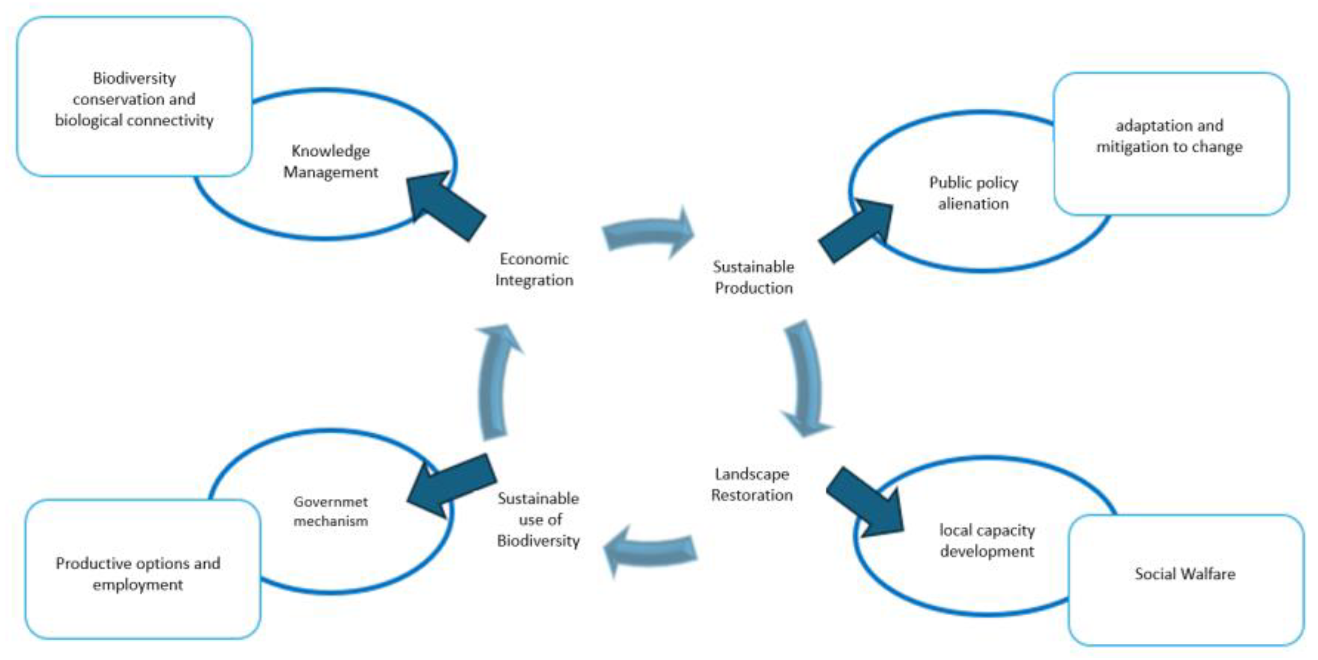
Figure 3.
coastline extension by a federal entity in kilometers. Note: The figure shows the extension in kilometers of existing coastline by entity in Mexico. Figure taken from Source: INEGI, “Coastal extension by entity in Mexico,” Mapas de México. Accessed: Sep. 13, 2024. [Online]. Available: https://www.facebook.com/mapasmexico/photos/mapa-263-17-estados-tienen-litoral-en-el-país-siendo-bajacaliforniasur-el-que-má/1488460997948852/?locale=es_LA. [27].
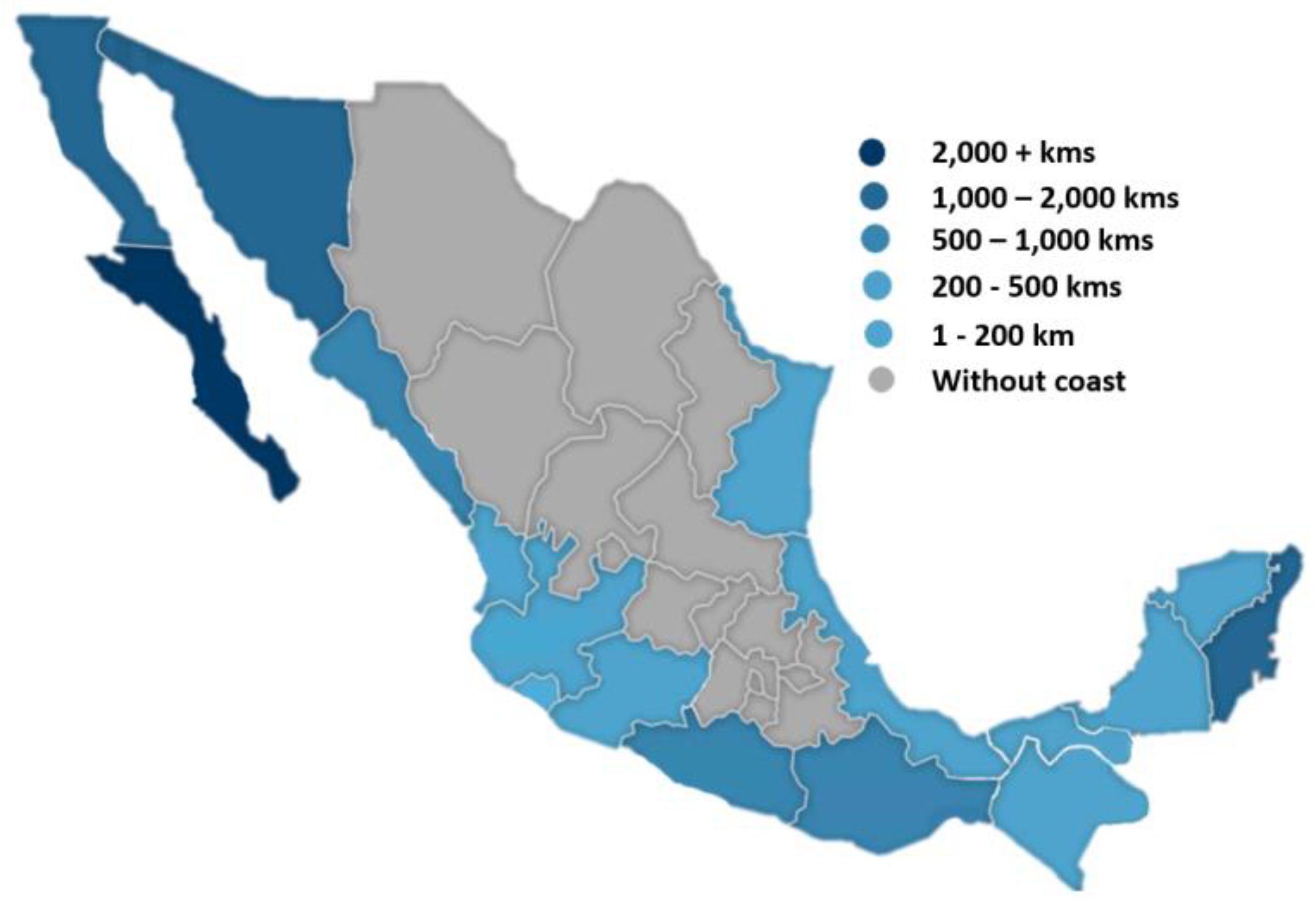
Figure 4.
fragmentation of the lagoon system in Veracruz México. Note: the areas marked in red show the fragmentation sites of the lagoon system in Veracruz Mexico. Source: Google Earth. (2024, August 27). Veracruz State. Google Inc. [28].
Figure 4.
fragmentation of the lagoon system in Veracruz México. Note: the areas marked in red show the fragmentation sites of the lagoon system in Veracruz Mexico. Source: Google Earth. (2024, August 27). Veracruz State. Google Inc. [28].
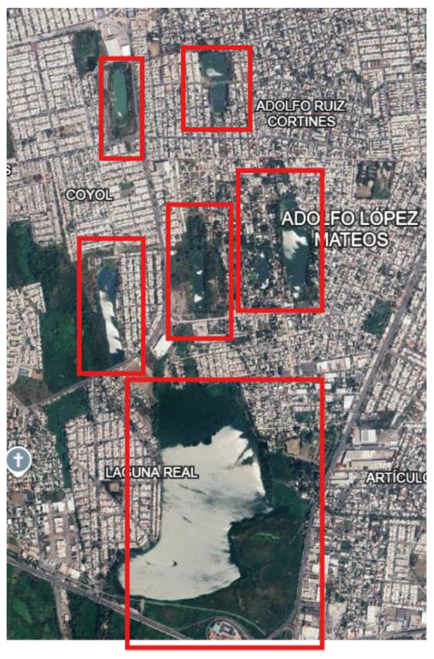
Figure 5.
Metabolic cicles of urban development. Source: J. M. Perlaza Rodríguez, A. G. Guida, and Á. M. Díaz Márquez, “Urban metabolism of human settlements in small island-protected environments,” Environmental and Sustainability Indicators, vol. 21, p. 100324, Feb. 2024, doi: 10.1016/j.indic.2023.100324 [29].
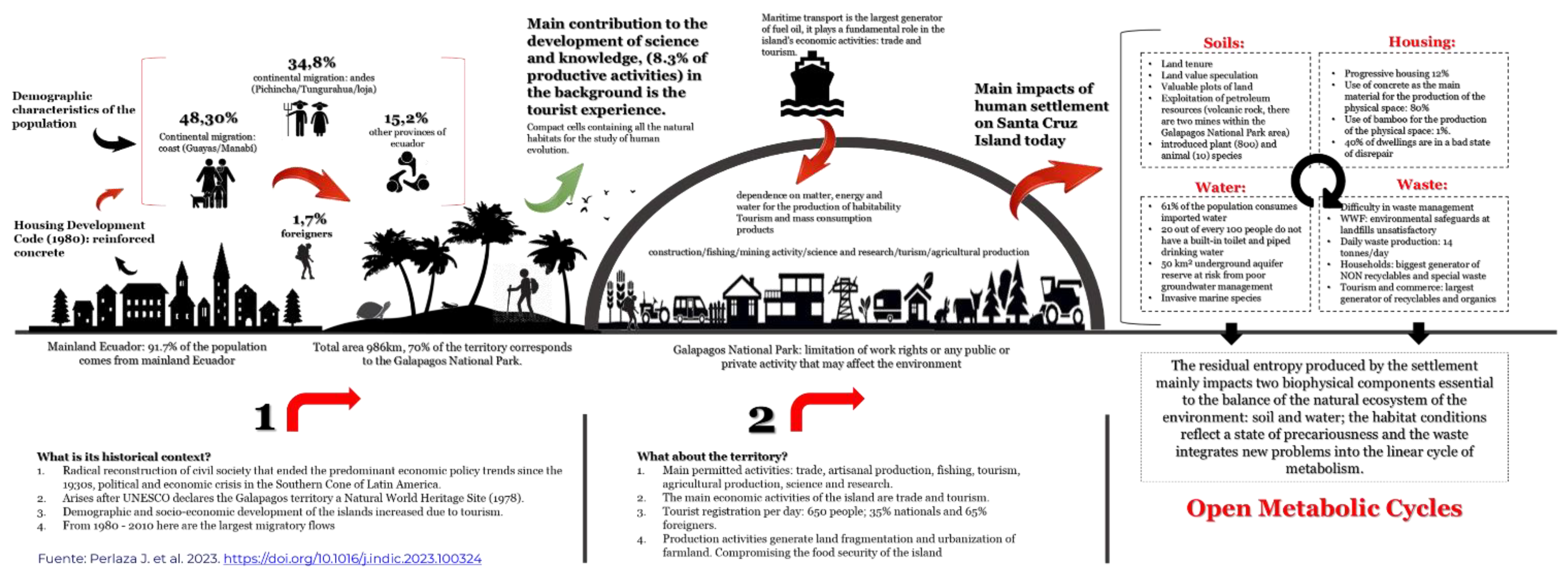
Figure 6.
urban wetlands in Veracruz-Boca del Rio. Source: Sánchez Vigil, G. (2024, August 29). Urban wetlands in Veracruz-Boca del Río. INECOL Institute of Ecology A.C. [41].
Figure 6.
urban wetlands in Veracruz-Boca del Rio. Source: Sánchez Vigil, G. (2024, August 29). Urban wetlands in Veracruz-Boca del Río. INECOL Institute of Ecology A.C. [41].
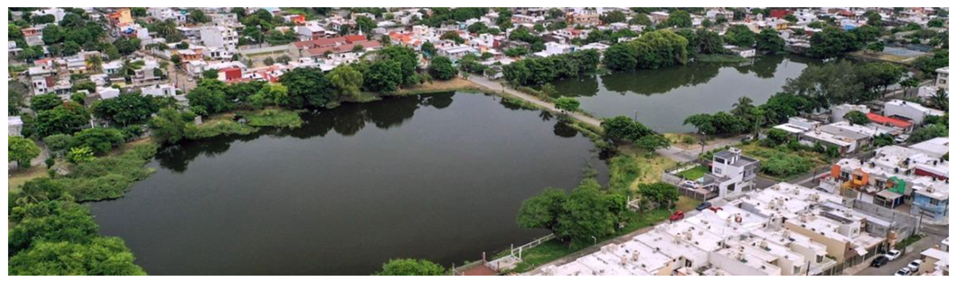
Figure 7.
Map of species in potential danger of extinction in Veracruz, Mexico. Note: the map of the quantity of species on a red/blue scale for the amounts of species in potential danger of extinction in the state of Veracruz, Mexico, concerning NOM-059. Source: CONABIO. (2024, October 21). Potential map of species at risk of extinction in Mexico. Comisión Nacional para el Conocimiento y Uso de la Biodiversidad. [47].
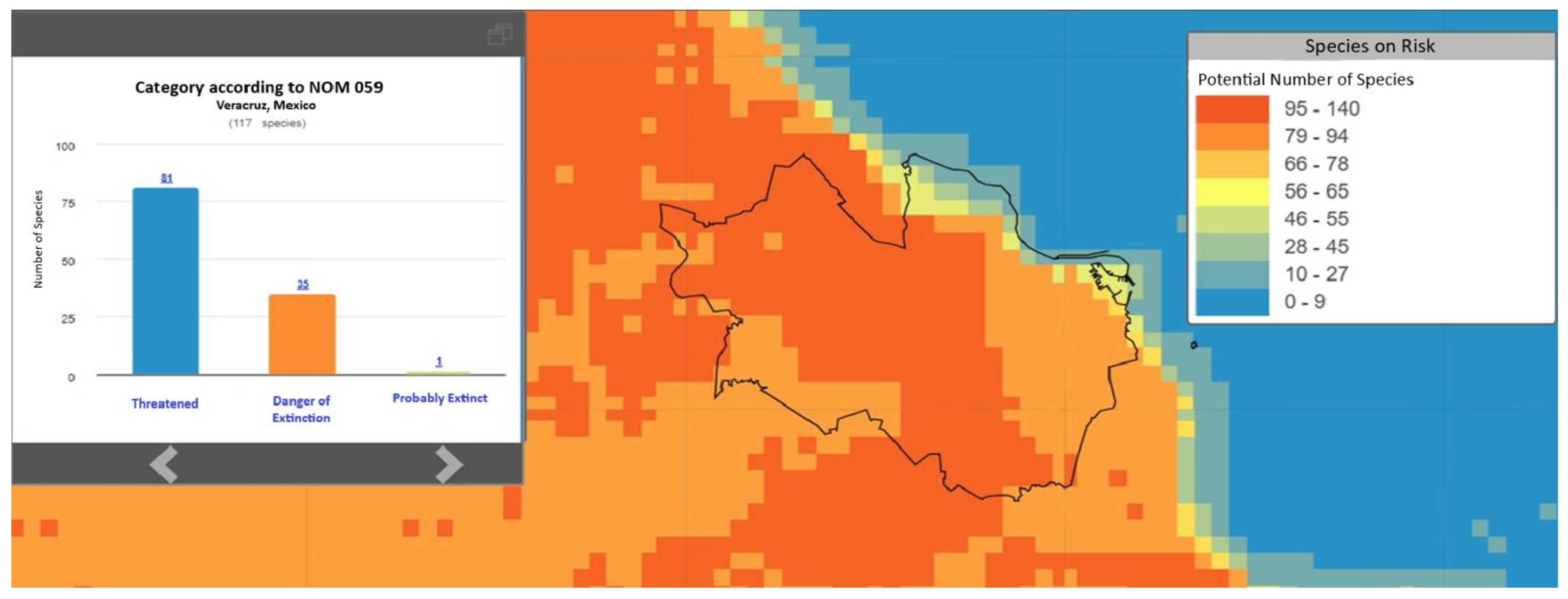
Table 1.
Analysis of the Case Study: Fragmentation of ecosystems in the Metropolitan region of São Paulo, Brazil.
Table 1.
Analysis of the Case Study: Fragmentation of ecosystems in the Metropolitan region of São Paulo, Brazil.
| Aspect | Description |
| Context | Rapid urban growth and industrial expansion in São Paulo, transforming natural landscapes into urbanized areas and fragmenting natural habitats. |
| Impacts | Fragmentation of local ecosystems, affecting biological connectivity and causing the loss of native biodiversity. |
| Data and Evidence |
Environmental monitoring studies and spatial analysis document the reduction of green areas and changes in the composition of local biodiversity. |
| Implications | Need for policies to integrate green infrastructure and restore natural habitats, promoting sustainability and mitigating environmental impacts. |
Table 2.
Analysis of the effects of urbanization and industrialization in literature.
| Topic | Description | Bibliographic Reference |
| Spatial and Temporal Scale |
Most studies focus on limited spatial and temporal scales, making it difficult to understand the long-term, large-scale effects of urbanization on biodiversity. Examples of large-scale studies are needed. | [10] |
| Impacts Indirect |
There are more studies on the direct impacts of urbanization, such as habitat loss, but less information on indirect impacts such as pollution and urban climate change. This information is crucial for a comprehensive analysis. | [9] |
| Adaptation and Resilience of Urban Species |
There are controversies about the ability of species to adapt to urban environments; some studies suggest adaptation and prosperity, while others indicate difficulties in the face of rapid environmental transformations. More case studies are required. | [8] |
| Conservation Urban |
Although the importance of conserving fragments of urban ecosystems is recognized, there is debate about the most effective strategies, such as the implementation of green infrastructure and ecological restoration. Examples of success should be provided. | [11] |
Table 3.
Analysis of the María Aguilar River Interurban Ecological Corridor, located in Costa Rica.
| Topic/Appearance | Description | Reference |
| Definition of Ecological Corridors | The CBM is a conservation initiative that covers several countries in Central America and southeastern Mexico, promoting connectivity between ecosystems. | [17] |
| Importance | It highlights the importance of CBM for large-scale conservation, addressing habitat fragmentation, and the protection of regional biodiversity. | [18] |
| Implementation Example | Implementation at the regional level involving multiple countries and states, promoting international collaboration in conservation. |
[19] |
| Implementation Scale | Regional: Transnational initiative that spans multiple countries and states. | [20] |
| Recent Advances | Progress in creating effective ecological corridors and protecting key habitats for threatened and migratory species in the region. | [21] |
Table 4.
Analysis of the Mesoamerican Biological Corridor (CBM).
|
Aspect / Example |
María Aguilar River Interurban Ecological Corridor, Costa Rica | Mesoamerican Biological Corridor (CBM) |
| Definition and Description |
Vegetation strips influence ecological processes and provide goods and services [12]. | Conservation initiative that covers several countries in Central America and southeast of Mexico, promoting connectivity between ecosystems. |
| Importance and Application |
Essential for the conservation of biodiversity and urban biological connectivity; It is integrated into territorial planning policies. | Vital for large-scale conservation, it addresses habitat fragmentation and protects regional biodiversity. |
| Advances and Achievements | Successful implementation in urban planning policies, highlighting the relevance of urban ecological connectivity. | Progress in creating effective ecological corridors and protecting key habitats for threatened and migratory species. |
Table 5.
Matrix analysis of the María Aguilar River Interurban Ecological Corridor and the Mesoamerican Biological Corridor (CBM).( 1.-Los corredores ecológicos. Fundamentos y aplicación en espacios protegidos. ).
Table 5.
Matrix analysis of the María Aguilar River Interurban Ecological Corridor and the Mesoamerican Biological Corridor (CBM).( 1.-Los corredores ecológicos. Fundamentos y aplicación en espacios protegidos. ).
|
Appearance / Example |
Definition and Description |
Importance and Application |
Advances and Achievements |
| María Aguilar River Interurban Ecological Corridor, Costa Rica |
[13] Defines ecological corridors as "strips of vegetation incorporated into the landscape that influence ecological processes and provide a variety of goods and services." | It integrates territorial planning policies, essential for biodiversity conservation and urban biological connectivity. | Successful implementation in urban planning policies, highlighting the relevance of urban ecological connectivity. |
| Mesoamerican Biological Corridor (CBM) | Regional conservation initiative covering several Central America and southeastern Mexico countries promotes connectivity between ecosystems. | Vital for large-scale conservation, it addresses habitat fragmentation and protects regional biodiversity. | Progress in creating effective ecological corridors and protecting key habitats for threatened species and Migratory. |
Table 6.
Data used in the CONABIO study. Data obtained from the Geo-graphic Digital Space (ESDIG).
| Average Annual Precipitation | 1316.1166 | ||
|---|---|---|---|
| Actual Vegetation | Popal | Hydrophilic Vegetation |
Primary |
| Potential Vegetation | Ecological Floristics Physiognomy |
Coastal Dune Vegetation | |
| Climate | Warm Humid Medium | ||
| Average Anual Temperature | 22°C To 28°C | ||
| Bird Protection | Aim 12 Aim 1 |
129 149 |
|
| Dominant Grounds | Complementary Arenosol Complementary |
||
Table 7.
Matrix analysis for the development of sustainability indicators with multiscale analysis for urban ecosystems.
Table 7.
Matrix analysis for the development of sustainability indicators with multiscale analysis for urban ecosystems.
| Indicator | Description | Multiescalar Application |
| Habitat Fragmentation Indicators |
They measure the degree of fragmentation of urban ecosystems and the connectivity between habitat fragments. | - Local Scale: Evaluation of the distribution and size of habitat patches within a specific city. - Regional Scale: Analysis of ecological corridors between urban and natural areas. - Global Scale: Comparison of fragmentation patterns in cities on different continents. |
| Species Diversity Indicators |
They evaluate the richness and abundance of species in urban areas. | - Local Scale: Biodiversity censuses in parks and urban green areas. - Regional Scale: Comparison of species diversity between different urban regions. - Global Scale: Analysis of biodiversity patterns in cities worldwide. |
| Ecosystem Services Indicators |
Measure the provision of key ecosystem services such as climate regulation, air quality and water management. | - Local Scale: Evaluation of air quality and thermal regulation in urban areas. - Regional Scale: Study of water management in urban and rural basins. - Global Scale: Comparison of ecosystem services between different global urban contexts. |
| Human Wellbeing Indicators |
They relate the presence of urban nature to the health and well-being of urban communities. | - Local Scale: Surveys of perception of the natural environment and well-being in urban neighborhoods. - Regional Scale: Correlation studies between access to green spaces and public health in regional cities. - Global Scale: Evaluation of urban health policies and their relationship with the presence of nature. |
Table 8.
Multiscale similarities and differences table.
| Aspect | Local Scale | Regional Scale | Global Scale |
| Focus | Urban neighborhoods and individual habitat fragments | Connectivity between urban and natural areas | Urbanization patterns across cities worldwide |
| Key Analysis | Habitat fragmentation, species inventory | Ecological corridors, landscape connectivity | Comparative biodiversity trends, policy benchmarking |
| Methods Used | GIS mapping, field surveys | GIS modeling, connectivity analysis | Global databases (GBIF), comparative studies |
| Expected Outcomes | Identify critical fragmentation points, suggest localized interventions | Propose regional ecological corridors, enhance species mobility | Develop global conservation strategies, identify best practices |
Disclaimer/Publisher’s Note: The statements, opinions and data contained in all publications are solely those of the individual author(s) and contributor(s) and not of MDPI and/or the editor(s). MDPI and/or the editor(s) disclaim responsibility for any injury to people or property resulting from any ideas, methods, instructions or products referred to in the content. |
© 2025 by the authors. Licensee MDPI, Basel, Switzerland. This article is an open access article distributed under the terms and conditions of the Creative Commons Attribution (CC BY) license (http://creativecommons.org/licenses/by/4.0/).
Copyright: This open access article is published under a Creative Commons CC BY 4.0 license, which permit the free download, distribution, and reuse, provided that the author and preprint are cited in any reuse.


