
Submitted:
14 December 2024
Posted:
18 December 2024
You are already at the latest version
Abstract
Objetives:Analyze the techniques that are most effective in basins and water resources. Determine the most widely used optimization methods at an international level. List countries that have the largest number of related studies. Methodology:A systematic bibliographic review study was carried out on the use of optimization and spatial modeling techniques in basins and water resources in the last 14 years. A search was considered in the Scopus and Scielo databases. The observation technique was used to extract the information and the indicators were recorded in an evaluation form (Title, Author, Year, Country, Sample, Technique). Result: The most effective technique is the use of Ge- ographic Information Systems (GIS). The most widely used techniques are GIS, Minimum Cumulative Resis- tance (MCR) and the Soil and Water Assessment Tool (SWAT). The countries that highlight the relevance of this study are China leading the list with 6 studies, fol- lowed by Colombia with 3, Spain with 2 investigations and some other countries such as Peru, Chile, the USA and Tunisia with 1 investigation respectively. Conclusion: The analysis of the techniques used in spatial modeling and optimization for watersheds and hy- drographic resources shows that Geographic Information Systems (GIS) stand out as the most effective tool due to their versatility and ability to integrate spatial and temporal variables in complex management scenarios. Minimum Cumulative Resistance (MCR) stands out for its contribution to ecological connectivity and landscape stability, while the SWAT model is particularly useful in water and sediment quality management in agricultural watersheds.
Keywords:
optimization
; basins
; spatial
; modeling
1. Introduction
The spatial modeling and optimization for watersheds and water resources have become indispensable tools to address the challenges associated with sustainable water management. Flood estimates, necessary for the design of civil works and risk zoning, highlight the relevance of understanding and predicting hydrological phenomena, which are often aggravated by the effects of climate change and human intervention [1] . In parallel, water systems face pollution problems, not only from domestic micropollutants, but also from the impact of production processes and human activities, which directly affects public health and ecosystems [2,3,4]. This problem is aggravated by soil erosion, which generates sedimentation in waterways, loss of fertility and decreased water quality, compromising the sustainability of agricultural activities and food security [5]. Efficient management of water resources, especially in arid and semi-arid regions, becomes a priority due to their vulnerability to scarcity and pressure from human activities. In this sense, hydrological planning plays a crucial role, relying on technologies such as geographic information systems and optimization models that allow the analysis of large volumes of data, simulation of different scenarios and design of adaptive policies that improve water management for agricultural, domestic and industrial uses [6,7,9]. These tools not only contribute to mitigating the effects of droughts and preventing disasters, but also to balancing the use of resources with environmental conservation. On the other hand, watersheds, being fundamental sources of fresh water for human consumption and economic development, are closely linked to water security and social well-being. Their degradation puts at risk not only their hydrological potential, but also the economic stability of local communities, especially in regions where water is scarce [8,10,11]. The transition towards more sustainable and environmentally conscious water management models, driven by the global perception of scarcity, has been key to integrating water and social policies that promote sustainable development, regardless of the level of development of societies [15]. Accelerating the construction of comprehensive models that combine ecological security and water use is urgent. These models must address both technical challenges and local conditions, considering factors such as geography, climate and socioeconomic dynamics, to ensure the equitable and sustainable use of water resources [8,12,13,14]. In this way, optimization and spatial modeling are not only presented as technical solutions, but also as strategic tools to ensure human survival and development in a world where water is increasingly scarce.
Given this context, the need to adopt modern approaches and advanced tools to optimize water resource management becomes evident. Therefore, the objectives of the study are: a) to analyze the techniques with the highest percentage of effectiveness, b) to identify the countries that study this context the most.
2. Methodology
2.1. Type of Study
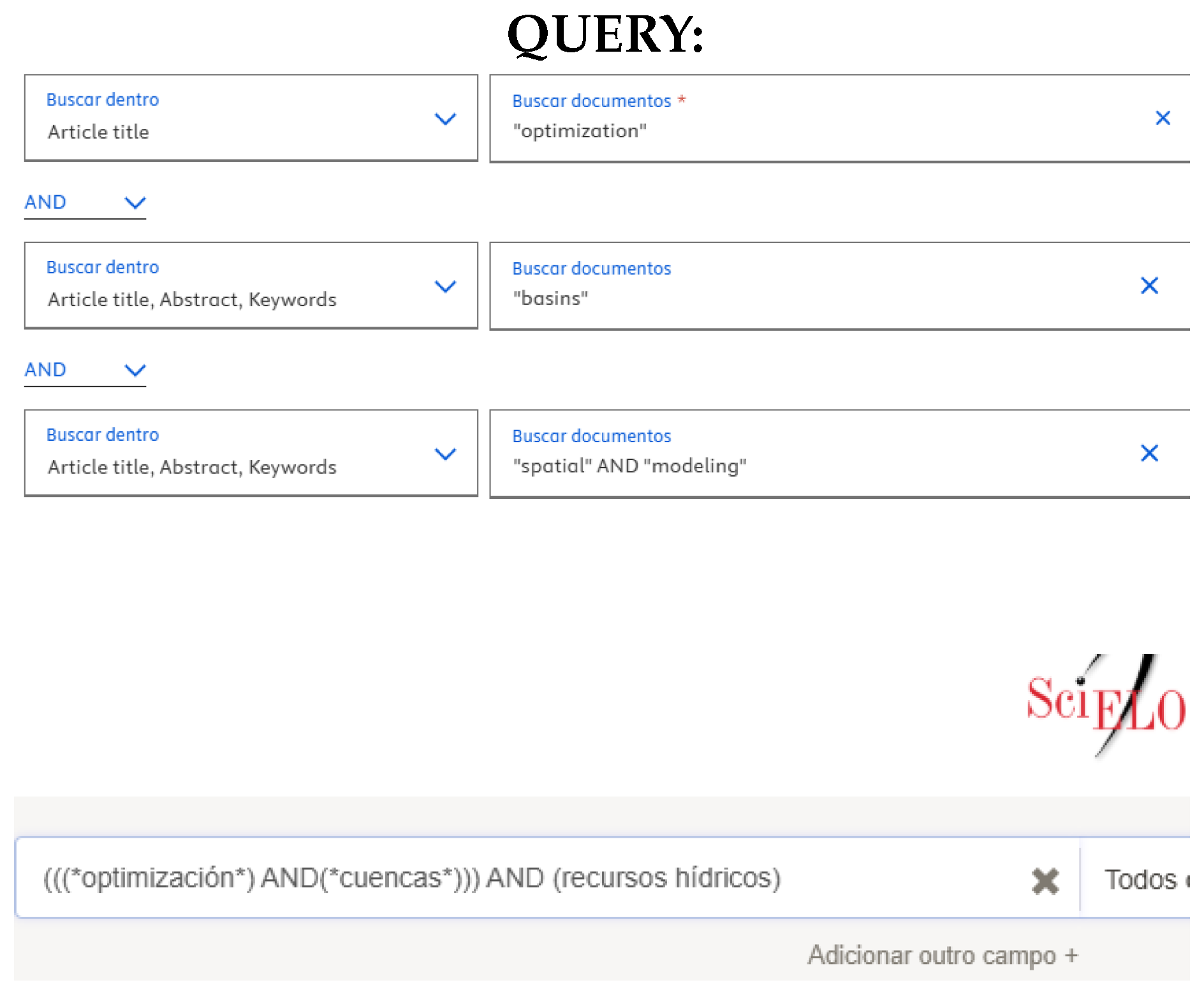
This study is based on a comprehensive systematic literature review on water resources optimization and spatial modeling, combining spatial statistics methods and advanced optimization techniques. The search focused on research published between 2011 and 2024, covering both articles in English (n=7) and Spanish (n=8), from prestigious indexed journals and recognized scientific databases such as Scopus and Scielo. To ensure the relevance of the results, only studies that applied optimization, spatial statistics methods, and addressed issues related to hydrology in basins were selected. The keywords used included "optimization", "basins" and "spatial AND modeling", allowing a comprehensive exploration of the topic. A global perspective was prioritized, including studies carried out in various regions of the world, to capture the breadth of approaches and techniques applied in different contexts. Studies that did not apply spatial statistics methods or topics of basin hydrology were excluded.
2.2. Technique and Instruments
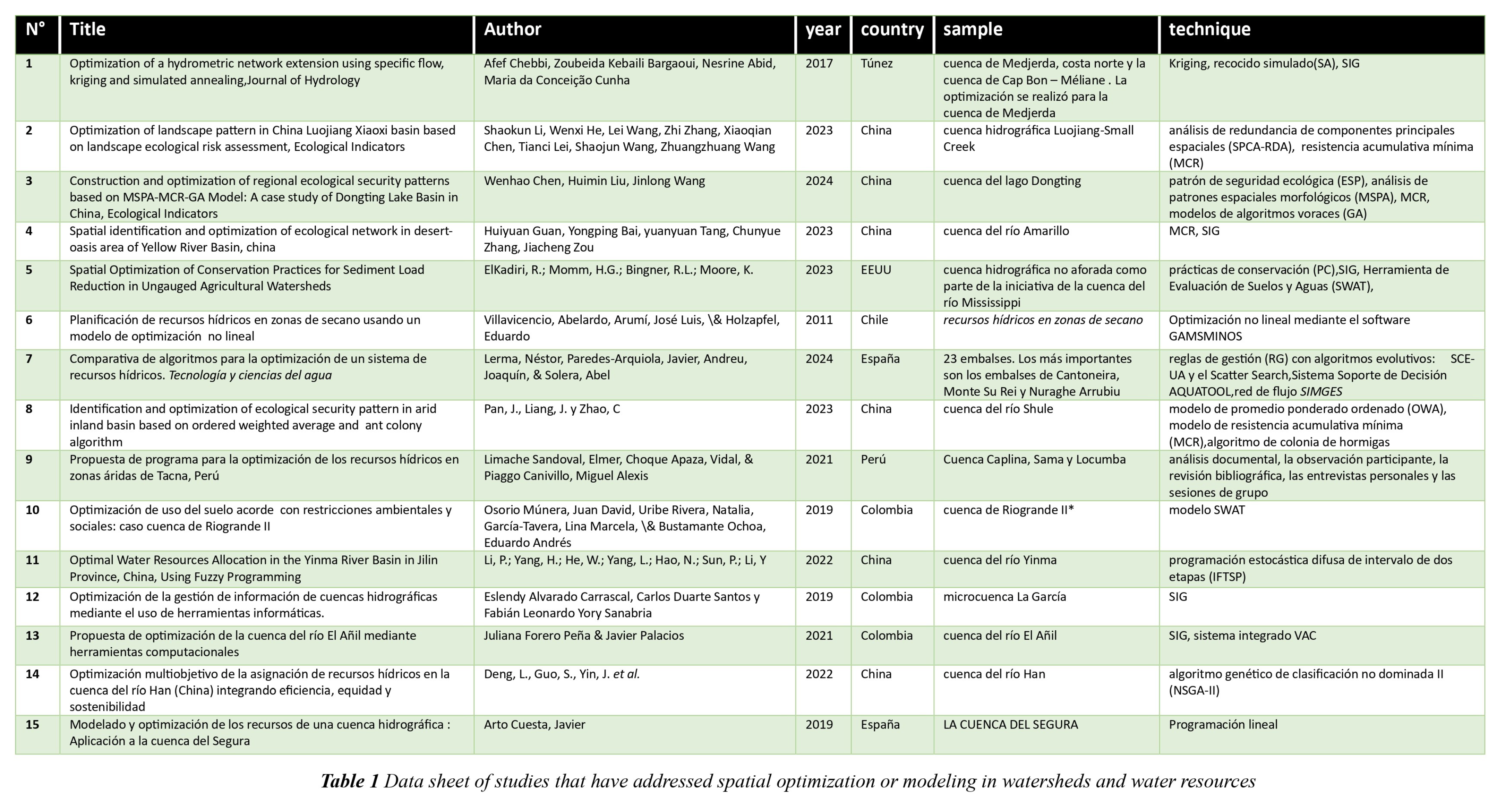
The documentary observation technique was used to systematize the selected articles. To organize the information, a data sheet was used specifically designed to record the following indicators: Title, Author, Year, Country, Sample and technique. The information is presented in Table 1.
2.3. Bibliographic Search Procedure
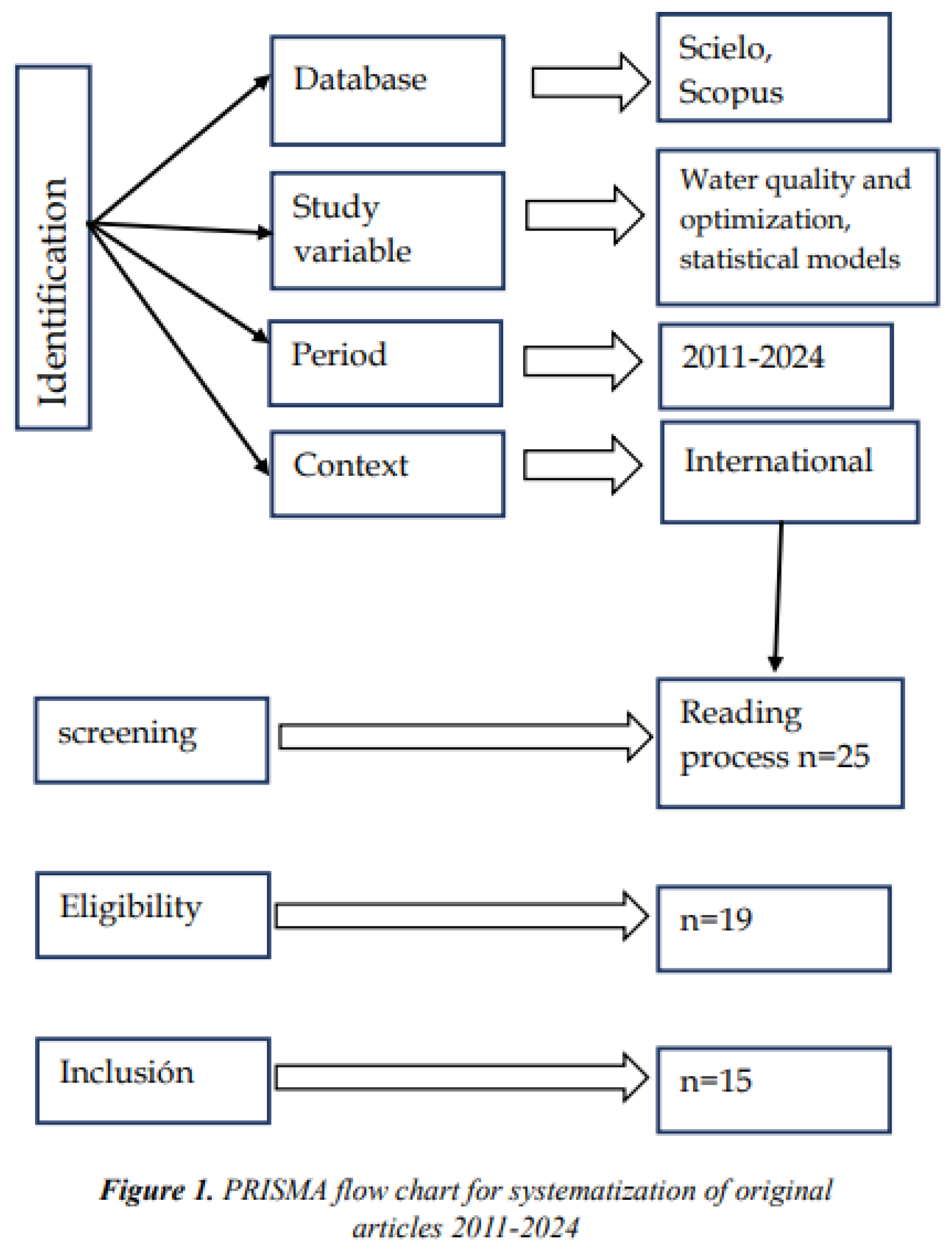
Scopus and Scielo databases were used, whose topics are associated with the field of study of watersheds with some kind of optimization and spatial statistics. This information search period lasted four days from November 25 to 29, 2024. The best match search information was: Spatial identification and optimization of ecological network in desert-oasis area of Yellow River Basin, China, Ecological Indicators[4]. and Proposal for a program for the optimization of water resources in arid zones of Tacna, Peru [9]. The study selection process was based on following the four phases of the flowchart called PRISMA. Figure 1 shows the entire process developed. In the first stage, a total of 25 articles were identified at an international level (Scopus, Scielo) using the keywords in the selected databases, which were considered as possible studies for systematization. In the second stage (screening), all the titles, abstracts and methodology of the studies were read. In the third stage, the studies were identified as eligible (n=19) and those that were included were (n=15). In general, studies that were related to the established search criteria were included. Studies that did not apply spatial statistics methods or hydrology topics in basins were excluded.
3. Study Analisis
The data from the articles was organized using Excel templates, which allowed their systematization through qualitative analysis. The information was then presented in tables and graphs, classifying it by aspects such as author, year of publication, country, techniques used, sample size and study variable analyzed. This facilitated the description of the fifteen selected articles.
4. Results
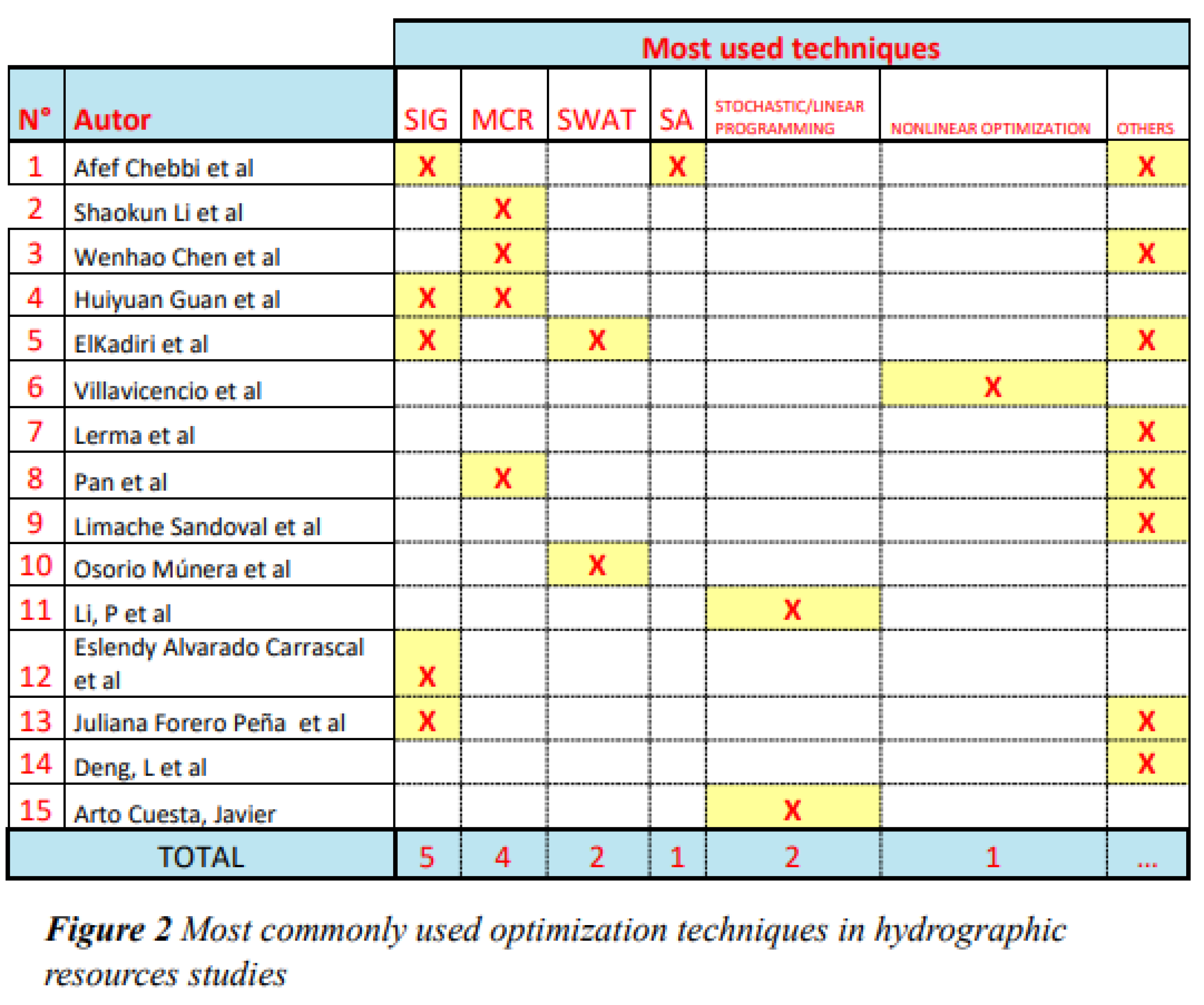
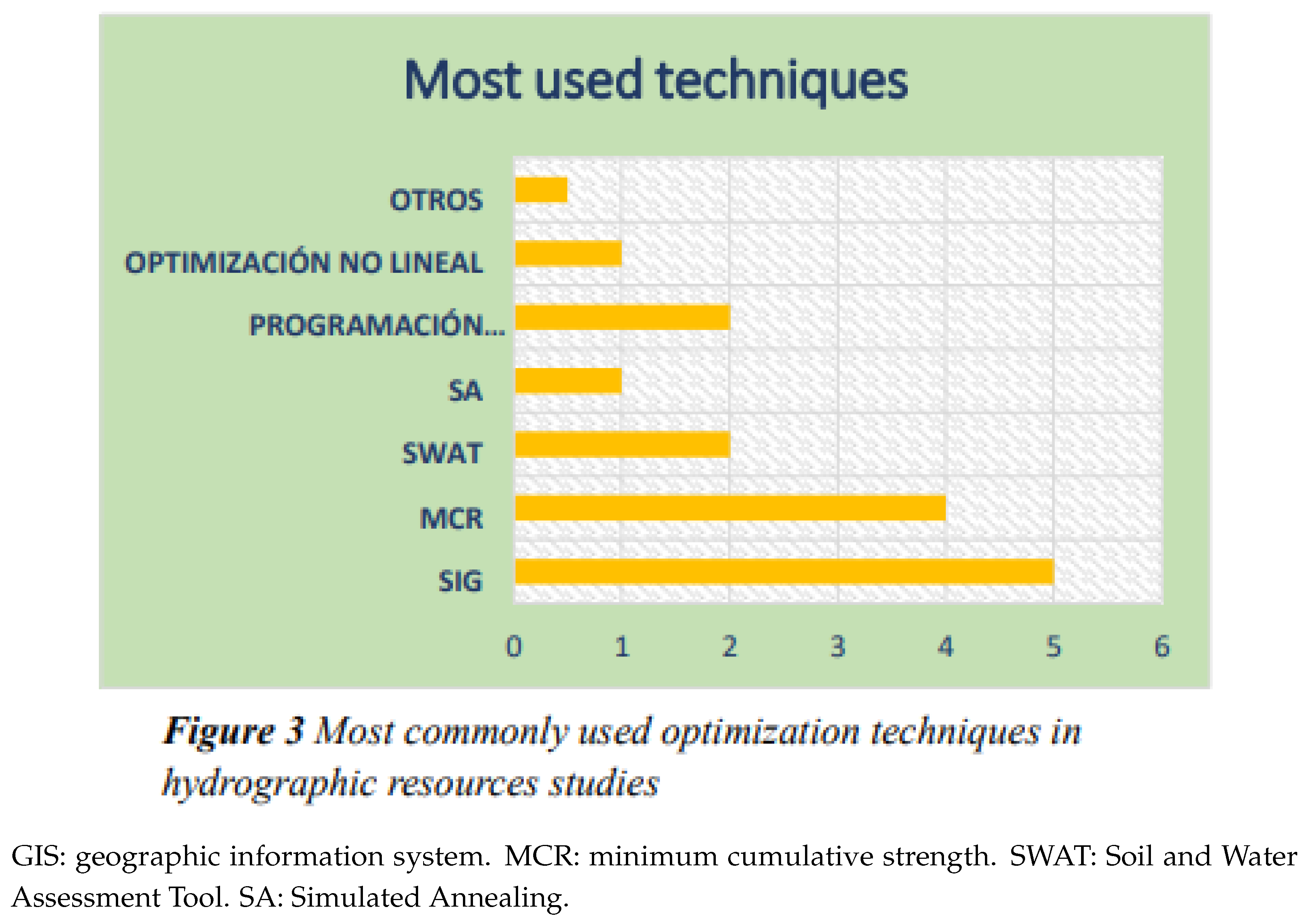
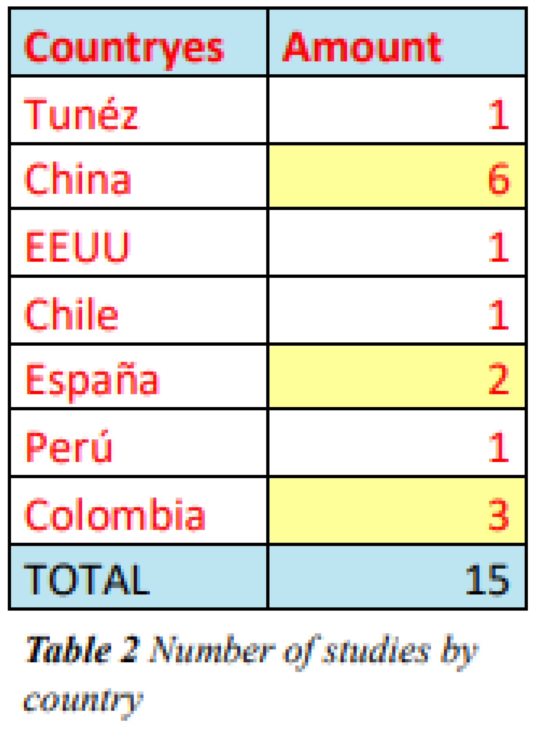
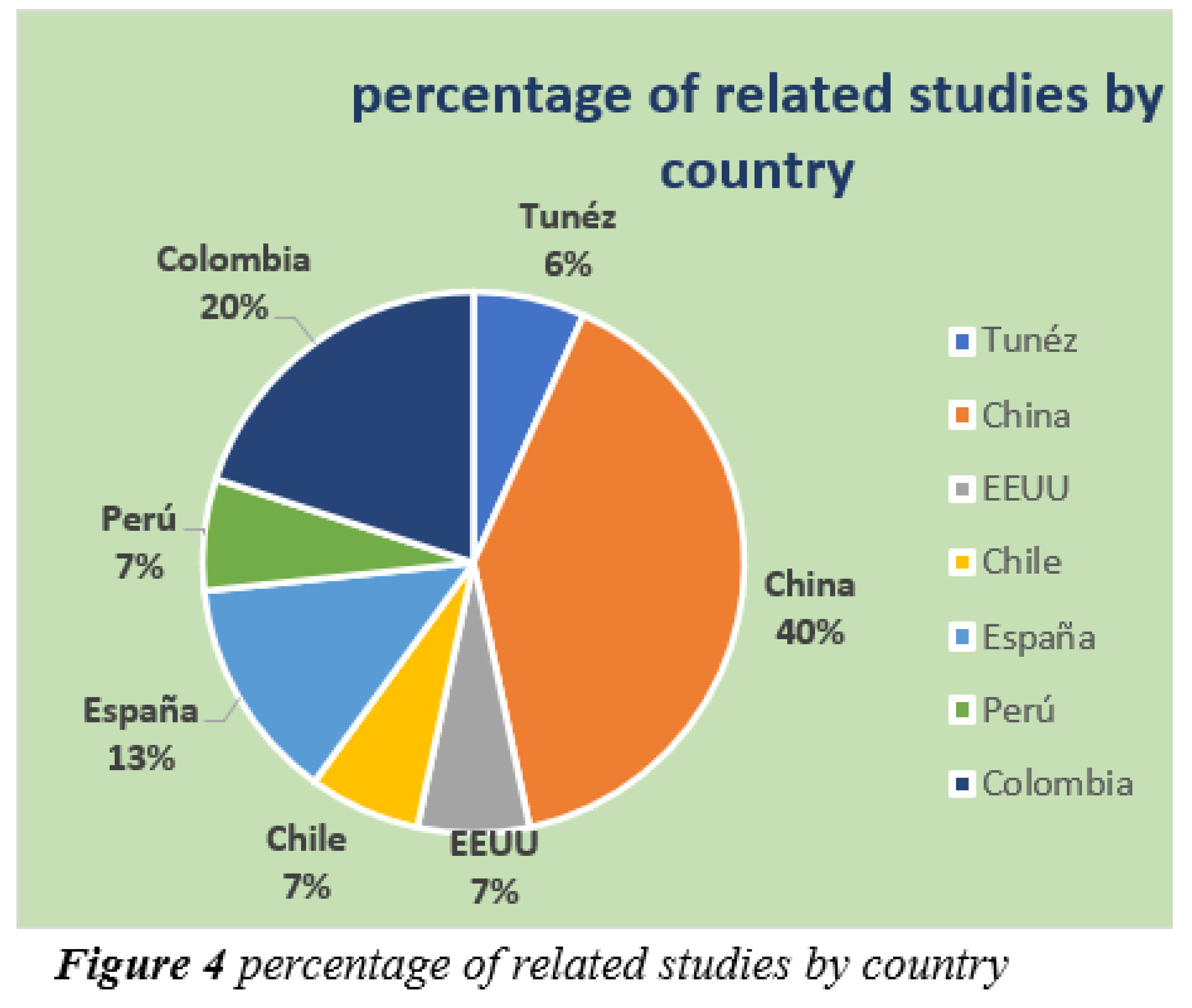
The studies carried out from 2011 to 2024 are described in Table 1. The fifteen studies have mostly developed Geographic Information Systems (GIS) (n=5), Minimum Cumulative Resistance (MCR) (n=4) and the Soil and Water Assessment Tool (SWAT) (n=2), among others that can also be visualized in the form of a bar graph for better understanding in Figure 3. These tools have been used mainly to address problems of watershed management, water resource optimization and spatial modeling. In terms of optimization techniques, all studies (n=15) applied methodologies that allow the efficient management of hydrological resources, reflecting a trend towards technological approaches based on spatial models. The number of techniques used by author is summarized in Figure 2, where the predominance of the aforementioned tools is evident. On the other hand, the geographical distribution of the research highlights the international relevance of this topic described in table 2 and Figure 4. China leads the list with 6 studies, followed by Colombia with 3, and Spain with 2 investigations. Other countries, represented by one study each, contribute to the global panorama, indicating a growing and diverse interest in the optimization of water resources worldwide. These results reflect the importance of the use of advanced tools such as GIS and optimization models, as well as the leadership of countries such as China in research on watershed and water resources management.
5. Discussion
GIS stands out as the most widely used tool in the selected studies, confirming its versatility in both modeling and environmental decision-making. GIS offers interpretive and analytical capabilities that allow for detailed spatial characterization of the variables and processes involved in watershed management [12]. In studies such as those applied in the North Fork Forked Deer River watershed, the integration of GIS with hydrological models has allowed quantifying the effects of conservation practices on sediment loads [5]. This approach demonstrates that, in addition to its instrumental role, GIS contributes to optimizing specific scenarios through the spatial location and evaluation of interventions. Minimum Cumulative Resistance (MCR) has been mainly used to improve the connectivity and ecological stability of landscape patterns, as observed in the Luojiang Xiaoxi watershed, where landscape connectivity was doubled after optimization [2]. Furthermore, in the Dongting Lake basin, the use of MCR combined with algorithms such as Monte Carlo and greedy proved to be effective in increasing ecological resilience and improving land use planning [3]. These applications underline the importance of the MCR model in the context of ecological restoration, especially in basins with significant pressures from urbanization and industrialization. The SWAT (Soil and Water Assessment Tool) model is another prominent tool that allows for the assessment of water quality and sediment distribution, particularly in agricultural basins. Although its use is less frequent (n=2), studies such as the one applied in the Mississippi River demonstrate its effectiveness in simulating alternative conservation scenarios and optimizing agricultural practices [5]. This model also emphasizes the importance of a spatiotemporal approach to address non-linear and location-dependent problems. Despite the advances, limitations in the application of these techniques were identified. In the case of GIS, its effectiveness depends largely on the availability and quality of data, as shown by the study in the El Añil River basin, where limited information from hydrometeorological stations made a complete analysis difficult [13]. Likewise, the SWAT model requires accurate data for calibrated scenarios, which can be an obstacle in regions with scarce monitoring. On the other hand, although the RCM and its variants have proven to be effective, their application could benefit from greater integration with other tools to optimize more complex modeling processes. The integration of these techniques allows to address complex and multidimensional problems in watershed management. From the optimization of water resources using tools such as the NSGA-II to balance efficiency and equity [14], to the design of conservation strategies adapted to specific conditions [6], the findings of this review can guide future sustainable management initiatives. Furthermore, the reviewed case studies demonstrate that evidence-based planning, supported by tools such as GIS and simulation models, is key to mitigating the impacts of climate change and anthropogenic pressure on watersheds. In summary, this review highlights how the combination of advanced modeling and optimization tools can improve water resources planning and conservation, ensuring integrated and adaptive management in the face of current environmental challenges.
6. Conclusion
The analysis of the techniques used in spatial modeling and optimization for watersheds and water resources shows that Geographic Information Systems (GIS) stand out as the most effective tool due to their versatility and ability to integrate spatial and temporal variables in complex management scenarios. Minimum Cumulative Resistance (MCR) stands out for its contribution to ecological connectivity and landscape stability, while the SWAT model is particularly useful in water quality and sediment management in agricultural watersheds. Although each technique has specific strengths, its effectiveness depends on the quality of the available data and the context of application. These findings provide a useful framework for tool selection in future projects aimed at sustainability and integrated water resources management.
References
- Afef Chebbi, Zoubeida Kebaili Bargaoui, Nesrine Abid, Maria da Conceição Cunha,Optimization of a hydrometric network extension using specific flow, kriging and simulated annealing,Journal of Hydrology, Volume 555, 2017, Pages 971-982, ISSN 0022-1694. [CrossRef]
- Shaokun Li, Wenxi He, Lei Wang, Zhi Zhang, Xiaoqian Chen, Tianci Lei, Shaojun Wang, Zhuangzhuang Wang, Optimization of landscape pattern in China Luojiang Xiaoxi basin based on landscape ecological risk assessment, Ecological Indicators, Volume 146, 2023, 109887, ISSN 1470-160X. [CrossRef]
- Wenhao Chen, Huimin Liu, Jinlong Wang, Construction and optimization of regional ecological security patterns based on MSPA-MCR-GA Model: A case study of Dongting Lake Basin in China, Ecological Indicators, Volume 165, 2024, 112169, ISSN 1470-160X, https://doi.org/10.1016/j.ecolind.2024.112169. [CrossRef]
- Huiyuan Guan, Yongping Bai, yuanyuan Tang, Chunyue Zhang, Jiacheng Zou, Spatial identification and optimization of ecological network in desert-oasis area of Yellow River Basin, China, Ecological Indicators, Volume 147, 2023, 109999, ISSN 1470-160X. [CrossRef]
- ElKadiri, R.; Momm, H.G.; Bingner, R.L.; Moore, K. Spatial Optimization of Conservation Practices for Sediment Load Reduction in Ungauged Agricultural Watersheds. Sistemas de suelos 2023 , 7 (1), 4. [CrossRef]
- Villavicencio, Abelardo, Arumí, José Luis, & Holzapfel, Eduardo. (2011). Planificación de recursos hídricos en zonas de secano usando un modelo de optimización no lineal. Obras y proyectos, (10), 73-80. [CrossRef]
- Lerma, Néstor, Paredes-Arquiola, Javier, Andreu, Joaquín, & Solera, Abel. (2015). Comparativa de algoritmos para la optimización de un sistema de recursos hídricos. Tecnología y ciencias del agua, 6(3), 79-92. Recuperado en 12 de diciembre de 2024, de http://www.scielo.org.mx/scielo.php?script=sci_arttext&pid=S2007-24222015000300006&lng=es&tlng=es.
- Pan, J., Liang, J. y Zhao, C. (2023). Identification and optimization of ecological security pattern in arid inland basin based on ordered weighted average and ant colony algorithm: A case study of Shule River basin, NW China.Indicadores ecológicos , 123, 110588. [CrossRef]
- Limache Sandoval, Elmer, Choque Apaza, Vidal, & Piaggo Canivillo, Miguel Alexis. (2021). Propuesta de programa para la optimización de los recursos hídricos en zonas áridas de Tacna, Perú. Revista Universidad y Sociedad, 13(4), 521-535. Epub 02 de agosto de 2021. Recuperado en 13 de diciembre de 2024, de http://scielo.sld.cu/scielo.php?script=sci_arttext&pid=S2218-36202021000400521&lng=es&tlng=es.
- Osorio Múnera, Juan David, Uribe Rivera, Natalia, García-Tavera, Lina Marcela, & Bustamante Ochoa, Eduardo Andrés. (2019). Optimización de uso del suelo acorde con restricciones ambientales y sociales: caso cuenca de Riogrande II. Semestre Económico, 22(52), 19-48. [CrossRef]
- Li, P.; Yang, H.; He, W.; Yang, L.; Hao, N.; Sun, P.; Li, Y.Optimal Water Resources Allocation in the Yinma River Basin in Jilin Province, China, Using Fuzzy Programming. Water 2022, 14, 2119. [CrossRef]
- Eslendy Alvarado Carrascal, Carlos Duarte Santos y Fabián Leonardo Yory Sanabria ;Optimización de la gestión de información de cuencas hidrográficas mediante el uso de herramientas informáticas. (2019). El Centauro, 9(12), 99-107. https://revistas.unilibre.edu.co/index.php/centauro/article/view/5836.
- Juliana Forero Peña & Javier Palacios , Propuesta de optimización de la cuenca del río El Añil mediante herramientas computacionales,2021, ISSN: 1909-2520, ISSN-e: 2590 8219, Periodicidad: Semestral, vol. 16, núm. 31, 2021, http://portal.amelica.org/ameli/journal/671/6713631005/.
- Deng, L., Guo, S., Yin, J. et al. Optimización multiobjetivo de la asignación de recursos hídricos en la cuenca del río Han (China) integrando eficiencia, equidad y sostenibilidad. Sci Rep 12 , 798 (2022). [CrossRef]
- Arto Cuesta, Javier ; Modelado y optimización de los recursos de una cuenca hidrográfica: Aplicación a la cuenca del Segura, 2019, http://hdl.handle.net/10902/17161.
Disclaimer/Publisher’s Note: The statements, opinions and data contained in all publications are solely those of the individual author(s) and contributor(s) and not of MDPI and/or the editor(s). MDPI and/or the editor(s) disclaim responsibility for any injury to people or property resulting from any ideas, methods, instructions or products referred to in the content. |
© 2024 by the authors. Licensee MDPI, Basel, Switzerland. This article is an open access article distributed under the terms and conditions of the Creative Commons Attribution (CC BY) license (http://creativecommons.org/licenses/by/4.0/).
Copyright: This open access article is published under a Creative Commons CC BY 4.0 license, which permit the free download, distribution, and reuse, provided that the author and preprint are cited in any reuse.


