Submitted:
17 December 2024
Posted:
17 December 2024
You are already at the latest version
Abstract
The number of major floods globally has been consistently significant in recent years. By using several methods of acquiring and processing geospatial data, this research aims to develop a digital terrain model that supports the modeling of sudden increases in water levels in a river to provide a true picture of the areas at risk. The main contribution of this research is the way to perform coupled geospatial, hydrological and hydraulic calculations, which are performed in the area of interest and which will highlight the characteristics of the water flow corresponding to the maximum flows with the exceedance probabilities of 10%, 1%, 0.5% and 0.1%, as well as those corresponding to the maximum flows resulting from the storage dam failure scenarios in the area. The research results indicate that the creation of a 3D model at the river basin level is the most important step in flood risk management.
Keywords:
Sustainability
; Flood Risk
; Digital Model Terrain
; GIS
; Water
; Integrated water resource management
1. Introduction
Currently, phenomena characterized by random natural hazards are particularly complex in terms of their occurrence, intensity, manifestation, and material damage. Understanding the complex interactions that occur when hazard phenomena occur requires the implementation, of integrated measurements and the use of complex monitoring systems, many of which based on digital terrain models and digital surface models generated by LiDAR scanning technology. Integrated measurements involve the collection, representation, interpretation and analysis of accurate and up-to-date geographic data, to study, monitor and manage the interactions that occur in addressing the problems generated by climate change, organizing of the territory, monitoring of various natural phenomena, assessing the risks and the effects they could have on human life, material goods and the environment. The technological progress recorded in the field of sensors intended for collecting geospatial data finds immediate applicability in the study of the factors that determine the occurrence of natural hazards. The rapid collection and processing of accurate geospatial data that can be easily integrated into dedicated software platforms are essential elements for supporting the risk management process and an essential component for developing prevention and protection measures for affected areas.
Essentially, based on geospatial information obtained from sensor data, hazard maps and numerical models are developed, integrating information about the history of the occurrence of hazard phenomena in a given geographical area, with the possibility of creating various virtual representation systems, based on which the probabilities and impacts in the areas with the highest risk of occurrence are determined. Having an overview of the affected areas, strategies can be developed to prevent, combat and mitigate the effects of these phenomena.
The paper aims to present how different methods of acquiring and processing geospatial data are used to create a complete, accurate and uniform Digital Terrain Model (DTM) for a hydrographic basin, based on which a series of maps can be generated, both hazard maps and flood risk maps with various exceedance probabilities. To perform numerical modeling of the propagation of flood waves that cause floods, a precise mapping of the risk areas is necessary, having as main support the very high-resolution digital terrain model (DTM) obtained from LiDAR measurements.
The novelty element offered by this work consists in the way of performing coupled geospatial, hydrological and hydraulic calculations, which are carried out in the area of interest and which will highlight the characteristics of the water flow corresponding to the maximum flows with the exceeding probabilities of 10%, 1% , 0.5% and 0.1%, as well as those corresponding to the maximum flows resulting from the scenarios of breaking the storage dams in the area. In the sense of the previously mentioned, the simulation related to the propagation of flood waves through the riverbed is based on a methodology that involves the reproduction of synthetic flood waves in different sections along the river, which are mainly the sections of hydrometric stations supplemented by sections upstream and/or downstream of the confluence with the main tributaries. The differentiator of this work is provided by the inclusion of the analysis of all the hydrotechnical works executed in the riverbed and the establishment of the influence of each hydrotechnical work on the hydraulic regime of the river. In this way, the coupled hydrological and hydraulic model includes all the constructive elements of the existing hydrotechnical works on the water course (longitudinal and transversal), which influences the hydraulic regime.
The development of flood hazard maps aims to implement preventive measures in vulnerable areas to reduce the risk of natural disasters. The Inter-Agency Standing Committee (IASC) [1] states that an emergency can turn into a risk when there are failures in disaster response decisions. So, the risk, if not controlled, can easily escalate into a disaster, due to the limited possibilities to propose countermeasures for such a situation. If, in one way or another, the risk can be managed, then the disaster is averted in most cases. By using specialized risk management, the course of a disaster can be modified, and response action during an emergency and afterwards, limits the negative effects on human and economic activity and on the environment.
Risk management [2] is a process of systematically identifying, analyzing, and reporting risk factors. It involves maximizing the probabilities and consequences of positive events and minimizing the probabilities and consequences of negative events. In this sense, the present research approach is strengthened by including the analysis of existing hydrotechnical works, seeking efficient methods to control the effects of a disaster, advancing the research to a higher level, as conducted by specialists in this field. [3,4].
2. Literature Review
The risks generated by floods have always been a source of concern for all interested parties, starting with the civilian population, continuing with local and central authorities, and ending with researchers. Each of the aforementioned parties has had as its main objective the protection of life and of the civilian and economic objectives in situations where floods occur. This is what Lim et al. [3] conclude in their research, suggesting the development of measures for preventing flood damage. Similarly, Parsian et al. [4] invoke the results of their research for protecting life and civilian objectives.
It can be asserted that an exceptional perspective is provided by Bayraktar et al. [5], who, in their research, focused on the detection of plants in exposed areas and the classification of these zones. This approach effectively complements the perspective centered on safeguarding human lives and the integrity of civil infrastructure. Through the application of the proposed model, the number of plants in wild areas can be determined. This methodology, which emphasizes the inclusion of nature among the priorities civilization must protect, holds significant importance.
Hu et al. [6] sought to evaluate how interpolation of multi-source spatial data can lead to efficient results for quantitative estimation of precipitation. This approach starts from the premise that floods have their origin to a large extent in the fact that the increase in flows is produced by large volumes of precipitation. The conclusion of Hu et al. [5] was that there has been a shift from interpolation to fusion of multi-source data for spatial estimation of precipitation. This conclusion is in line with the research line of the present work, which uses the principle of summarizing multi-source data to determine the floodability of the analyzed areas. Das [7] has the same approach and concludes the need to prepare maps of susceptibility, vulnerability, and flood risk. This conclusion generates directions of action regarding the construction of structures that can and should prevent floods, states Das [7]. In reality, these structures limit and control the effects of floods, more than preventing them. The same philosophy regarding the analysis of flood effects is also reflected in the research of Renschler et al. [8], which uses data provided by the floods caused by Hurricane Irene on August 28, 2011. Their research makes a comparison between the estimated situation, which should have been within controllable limits, and the reality caused by the release of a large amount of water to avoid the dam breaking in the affected area, which led to obtaining results that meant completing the information provided by government reports or scientific studies. These results concretely support the usefulness of multi-source data fusion. The same usefulness is also proven by Dash et al. [9] by identifying and validating flood maps or by Albano et al. [10] by the method proposed for the analysis and mapping of large-scale damage.
For areas or even countries that are frequently crossed by meteorological phenomena that can generate floods, information with this specificity is very useful, a fact proven by Saint-Martin et al. [11] by proposing the development of a DamaGIS database, which would collect and identify data on flood damage from several sources, including media sources or social networks. The efficiency of the existence of information sets is proven, especially since they are accessible through the resources of GIS software. The analysis conducted by Rosser et al. [12] happily completes the idea of Saint-Martin et al., by efficiently using the technological level reached by mobile phones. The analysis shows how smartphone users who document the events they witness and upload them to social media networks, in fact send geotagged information that can be effectively used to complete the information necessary for assessments and subsequent analyses or simulations.
Shifting the focus from flood control to flood mitigation, Liu et al. [13] attempted to estimate the impact of floods on affected areas by determining the impact on the lives of the population after a flood. Such an analysis can provide extremely useful results for increasing the efficiency of the recovery process of affected areas, applying a principle found in Business Continuity Management, ISO 22301 [14]. However, to be able to do such an analysis, it is necessary to have the other one, which provides information on flood maps.
3. Data and Methodology
3.1. Location of the Analyzed Area
The Prut River is the second longest tributary of the Danube [15], the most important river in Romania. The Prut River, with a length of 952.9 km, forms the border between Romania and Ukraine on 31 km, from Oroftiana to Lunca Ivancăuți, and between Romania and the Republic of Moldova on 711 km. From a hydrological perspective, the Prut River is divided into two areas of interest: the upstream sector of the Stânca Costești reservoir, which is approximately 139 km long, and the downstream sector, which is 591 km long. The Stânca Costești reservoir has an approximate surface area of 38 km² and represents the most important hydraulic construction on the Prut River.
According to the National Institute of Hydrology and Water Management [16], in the Prut-Birlad area, where the Prut River has the determining weight, there are 46 areas with potentially significant risk of fluvial flooding, of which 14 are with low risk. For these, 32 strategies have been developed so far, with the intention of covering all areas with potentially significant risk of medium and high-level floods. One of the important components for the management of this hydrographic area was the development of hydrological risk maps.
3.2. Methodology
In accordance with Directive 2007/60/EC [17], which establishes that EU Member States shall produce hazard maps and risk maps adapted to the zonal context, four categories of works are established, as necessary, to build the dataset required to produce hydrological risk maps for the Prut River:
- carrying out topo-bathymetric measurements on the Prut River and the Stânca Costești reservoir;
- creation of an integrated Digital Terrain Model for the Prut floodplain on both banks by integrating the topographic-bathymetric data produced within the project into the available digital terrain models;
- acquisition of satellite images/production of orthophotos and other types of geospatial data necessary for the production of flood hazard and risk maps;
- hydrological and hydraulic modeling in order to generate flood hazard and risk maps along the Prut River.
In a synthetic way, Figure 1 presents the execution diagram of risk maps.
To create these maps, in accordance with the provisions of Directive 2007/60/EC, three distinct flood scenarios have been developed.
The low-probability scenario (for maximum flows with a 0,1% probability of exceedance, corresponding to floods that have a chance of occurring once in 1000 years). Medium probability scenario (for maximum flows with a 1% probability of exceedance, corresponding to floods that have a chance of occurring once in 100 years). The high-probability scenario (for peak flows with a 10% probability of exceedance, corresponding to floods that have a chance of occurring once every 10 years).
It is important to note that the flood hazard map is a synthesis tool that includes a number of essential details. These details are relevant for each exceedance probability considered. One such detail is the flood boundary, which represents the extent of water in each scenario analyzed. Another key detail is the water depth or level, divided into 3 classes: water depth below 0.5 meters, water depth between 0.5 and 1.5 meters and water depth greater than 1.5 meters.
On the other hand, the flood risk map is a document that provides information on potential material and human damage in administrative-territorial units, depending on the different probabilities of exceeding the maximum flow in flood-prone areas.
3.2.1. The Digital Terrestrial Model
To streamline the process of creating risk maps, existing data in government collections is used, consisting of images with digital models, satellites and orthophotos, which are verified, validated and then converted into formats compatible with the GIS system chosen for implementation.
The existing digital models for the two banks of the Prut River have different characteristics, because of the fact that they are specific to the three riparian countries. For the Republic of Moldova and Ukraine, structures in the UTM 35 projection system and the Baltic Sea 77 altimetric system were used, there being no possibility of assessing the accuracy of the digital model with the help of control points. For the right bank, located on the territory of Romania, the data structures used were in the Sterographic 1970 projection system and the Black Sea 1975 altimetric system. In this case, an assessment of the accuracy could be made, using 21 control points. The result of the assessment can be seen in Table 1
Similarly, the orthophotomap and satellite image component shows differences between the two banks of the Prut River, for the same reasons. For the right bank of the Prut River, color orthophotomaps, scale 1:5000, georeferenced in the 1970 stereographic projection system, edition 2011, were taken. For the left bank of the Prut River, satellite images, in the 2008 edition (pdf format), non-georeferenced, and in 2011 (.jpg format), georeferenced in the UTM 35 projection system, were taken.
The information gaps on the left side of the Prut River, but also in the Stanca-Costesti accumulation area, required the completion of the model with data obtained from aerial laser scanning for an area of approximately 750 km2, with a density of 2 points/m2.
An extract from the flight plan for completing and updating the data from the Stanca Costesti area can be seen in Figure 2.
Details of the three flights performed to update data from the Stanca Costesti area are presented in Table 2, Table 3 and Table 4.
The digital terrain model for the hydrographic basin has been developed for three levels of detail:
- level A – very detailed, with a resolution of 1-2 m, covering restricted areas of particular complexity and importance, which require detailed analysis;
- level B - detailed, with a resolution of 4-5 m, covering the river courses and their main tributaries of sufficient length so that the results of hydraulic modeling are relevant;
- level C – low-detailed, with a resolution of 10-15 m for the rest of the river basin.
The digital terrain model of level A was obtained exclusively through aerial laser scanning, performed in such a way as to obtain a density of 2-4 points/m2.
The digital terrain model of level B can be obtained either by aerial laser scanning, performed so as to obtain a density of 1-2 points/m2, or by extracting the digital terrain model from images.
The level C digital terrain model was generally obtained from the integration and calibration of existing data, namely the acquisition of the digital terrain model with a resolution of 5-10 m from the National Agency for Cadastre and Real Estate Advertising or the vectorization of contour lines on 1:5000 scale topographic plans.
The time required to acquire the data necessary to generate the digital terrain model of levels A and B through aerial laser scanning was approximately 20 hours, including the movement of the aircraft in the project area.
From the LiDAR point cloud, the Digital Terrain Model (DTM) and the Digital Surface Model (DSM) were obtained by classifying them. Following the classification, the following point classes were generated: ground, low vegetation, medium vegetation, high vegetation, constructions, unclassified points. The ground class also included points located on the water surface.
Figure 3 illustrates the diagram of common aerial data collection operations and their integration with GPS (Global Positioning System) and IMU (Inertial Measurement Systems) data for processing and obtaining the digital model. Airborne sensors separately collect 2D and altitude data. The laser scanner and the IMU/GPS system are synchronized with the GPS reference signal and allow a way of data acquisition that facilitates their further processing. In this way, three-dimensional data sets are obtained, forming what is known as the "point cloud”.
The collected image set required further processing, which was performed by using the ULTRAMAP V 3.9 software [18], on a computer with Intel Core i7-8565U, 4 Cores, 1800MHz, 32 GB RAM. This software, which stands out for its manual editing tools for the digital surface model, a 3D visual analysis for a better perspective and good facilities for data export, requires the existence of some initial data, as can be seen in Figure 5.
Thus, to create a project in ULTRAMAP, the following initial data is required:
- Raw images, specifying that the image format is specific to the ULTRA-CAM Lp (dragonfly) camera [19];
- Internal orientations, which describe the internal geometry of the camera at the time the images were captured with it.
3.2.2. Topographic and Bathymetric Measurements
Topo-bathymetric measurements were conducted to restore and complete the existing support network, acquire topographic data necessary to generate transverse and longitudinal profiles, acquire data regarding water depth, and conduct surveys of engineering structures.
The following equipment was used to conduct the topo-bathymetric works:
The terrestrial reconnaissance procedure of the analyzed area is based on existing information, and these are registered with the institutions in the government area that manage hydrological information. In order to conduct terrestrial reconnaissance of the area, the points of the existing geodetic support network at the institutions that manage hydrological information were identified. The inventory of the conservation status of the support network points allowed the identification of areas with insufficient information, where it is necessary to complete the network with new points. This step, very important in carrying out the measurements, allowed the preparation of the network project and the establishment of the stationing/measurement sessions. The establishment of the optimal periods for executing static GNSS measurements was achieved by using a free planning software, GNSS Planning Tool.
After collecting bathymetric data, their processing to apply corrections and calculate the exact position of bathymetric points was performed with the SonarTRX program [22].
3.2.3. Conducting Cross-Sectional Profiling Within the Prut Riverbed and the Stânca-Costești Accumulation Area
Following the analysis, a number of 434 transverse profiles were determined and established. The distance between the transverse profiles being relative, varied depending on the morphological characteristics of the minor riverbed. For the bathymetric profiles, intermediate measurements were also performed, on shorter profiles, especially in the areas of inflection of the watercourse. Transverse profiles were also performed in areas of sudden slope changes, respectively in areas with reverse slope, to the extent that these areas can be identified in the field.
For each cross-sectional profile, common points were determined to connect the elevations resulting from the Digital Terrain Model with the topo-bathymetric measurements. The coordinates were determined by GPS measurements, the Real Time Kinematic (RTK) measurement method, using the ROMPOS reference stations [23], the closest to the project area, respectively the RO VRS 3.1 GG virtual station system. The measurement accuracy of the points on the cross-sectional profile was +/- 5 cm, in plan (Stereographic System 1970), and +/- 10 cm for normal elevations, the Black Sea reference 1975. In the terrestrial measurements on the cross-sectional profiles, points were measured at a maximum of 20 m, as well as at changes in the slope of the terrain.
The transverse profiles overlapped the trust values from the existing Digital Terrain Model found in government archives. The overlap area was approximately 50 to 100 meters, without exceeding the levee line. Figure 6 illustrates this overlapping action for the sector downstream of the locality of Prisacani
3.2.4. Creating Flood Maps
The creation of flood maps is based on the hydraulic calculation model implemented in the Hydrologic Engineering Center's (CEIWR-HEC) River Analysis System (HEC-RAS) [24].
The following data sets are used to apply the hydraulic calculation model:
- The main route of the Prut River and its main tributaries;
- Calculation cross-sections;
- Roughness coefficients;
- Hydraulic structures in the riverbed;
- Maximum flow values.
The aim is to develop hazard and risk maps corresponding to the exceedance probabilities of 10%, 1%, 0.5% and 0.1% for the Prut riverbed, through a coupled hydrological and hydraulic modeling. This approach allows the determination of the contribution of the Prut River tributaries corresponding to the flood waves on the Prut River.
4. Results
Hydrological modeling was conducted on river sectors between 2 successive hydrometric stations on the Prut River, using 6 hydrometric stations.
- The number of calculation cross-sections was 434, of which:
- 360 sections downstream of the Stânca-Costești Accumulation;
- 41 sections in the Stânca-Costești Accumulation area;
- 33 sections upstream of the Stânca-Costești Accumulation.
20 flood maps were generated, containing the orthophotomap, information about localities and land use, and the boundaries of flood zones generated for different exceedance probabilities.
Figure 7 and Figure 8 provide comparative images of the result obtained, Figure 7 presenting the area of the Prisacani hydrometric station with a 0% exceedance, and Figure 8 presenting the same area of the Prisacani hydrometric station, with a 0.5% exceedance. Comparing the two figures, the impact of a 0.5% overshot can be seen.
Figure 9 presents a map of the Mastacani - Galati sector. This is one of the 20 maps generated from the hydrological model. The map shows information for floods corresponding to maximum flows with exceedance probabilities of 0.1%, 0.5%, 1% and 10% on this sector of the Prut River. The exceedance probabilities are selected in accordance with the provisions of Directive 2007/60/EC.
Activities related to the organization and development of the territory, as well as to urban planning and administration, require the correct and up-to-date use of hazard and risk maps, developed at appropriate scales and levels of detail. The procedure for creating and using these documents in the context of natural risk factors is regulated at European level by directives and at national level by administrative acts that establish responsibilities at central, regional, county and local levels, as well as the management of associated databases.
5. Conclusions
Activities related to the organization and development of the territory, as stipulated by Law no. 350/2001 regarding territorial development and urban planning [25], as well as to urban planning and administration, require the correct and up-to-date use of hazard and risk maps, developed at appropriate scales and levels of detail. The procedure for creating and using these documents in the context of natural risk factors is regulated at European level by directives and at national level by administrative acts that establish responsibilities at central, regional, county and local levels, as well as the management of associated databases. However, regarding the risks generated by human activities, regulation is less developed. Although the expansion of instability phenomena induced by anthropogenic activities is more limited compared to natural phenomena, their impact can be significant at local or regional levels. For instance, subsidence caused by mining operations affects a substantial proportion of territories in certain areas. Current legislation [25] refers to mining areas only in the sense that they can be considered as disadvantaged areas. This categorization is used in the legislation [25] from a demographic point of view and not related to the actual impact caused by instability phenomena. Therefore, it is crucial to develop and adopt rules and standards in this field, as well as to introduce the obligation to include specific information in the process of developing land use and urban planning plans.
In the context of sustainable development and mitigating the negative impacts of extraction activities, mitigation measures and risk management strategies are essential. What can be considered as a set of proposals generated by this research for strategies that can be implemented to reduce the risk of flooding includes the following: the creation of retention basins; ecological rehabilitation of exploited areas; stabilization of slopes; efficient management of stormwater. The creation of retention basins, ecological rehabilitation of exploited areas, stabilization of slopes, and effective management of stormwater are some of the strategies that can be implemented to reduce flood risk. Furthermore, the involvement of local communities and stakeholders in the development and implementation of risk management plans can contribute to the creation of solutions well-adapted to the specific context of each site.
The ecological health and safety of human communities are closely linked to the efficient management of natural resources and landscapes. Quarries and ballast pits, in the context of the changes they induce in the environment, require special attention in the modeling and interpretation of flood risk maps, thus guaranteeing effective planning and response to extreme events. The rapid expansion of the urban environment is one of the most important global issues today. In order to successfully control situations resulting from this rapid urbanization, geospatial information needs to be as accurate and up-to-date as possible.
Correct geospatial information leads to accurate calculations, which is reflected in the increased effectiveness of hydrological forecasts and warnings in case of floods. Probably the most important finding of this research is that creating a 3D model at the level of a river basin represents the first and most important stage in flood risk management, since flood maps are developed based on geospatial data and a plan of measures is generated to combat and mitigate the effects of floods.
To create a 3D model of a hydrographic basin, current technologies enable the simultaneous acquisition of LiDAR aerial data and digital images. This represents one of the most used methods for developing a comprehensive cartographic database over relatively large areas. Although LiDAR technology and the software for processing these data are quite expensive, and specialists in the field are few, this technology has garnered significant interest across many domains. This is due to the elimination of the need for direct physical contact with the ground surface, as well as the vast number of data points—on the order of millions—that can be collected in a single measurement campaign.
Author Contributions
Conceptualization, C.I. and C.D.G.; methodology, C.I. and A.R.; software, A.R.; validation, L.O.F., C.D.G. and A.R.; formal analysis, L.D.L.; investigation, C.I. and A.R.; resources, C.D.G.; data curation, C.I.; writing—C.I. and A.R., X.X.; writing—review and editing, L.D.L.; visualization, L.O.F.; supervision, L.D.L.; project administration, C.I. and C.D.G.; funding acquisition, C.D.G. and L.D.L. All authors have read and agreed to the published version of the manuscript.
Conflicts of Interest
The authors declare no conflicts of interest.
References
- Guideline, EMERGENCY RESPONSE PREPAREDNESS, July 2015 IASC Task Team on Preparedness and Resilience, Available online:. Available online: https://interagencystandingcommittee.org/sites/default/files/migrated/2019-02/iasc_emergency_response_preparedness_guidelines_july_2015_draft_for_field_testing.pdf (accessed on 8 June 2024).
- ISO 31000:2018, Risk management. Available online: https://www.iso.org/iso-31000-risk-management.html (accessed on 12 July 2024).
- Lim, J.; Lee, K.-s. Flood Mapping Using Multi-Source Remotely Sensed Data and Logistic Regression in the Heterogeneous Mountainous Regions in North Korea. Remote Sens. 2018, 10, 1036. [Google Scholar] [CrossRef]
- Parsian, S.; Amani, M.; Moghimi, A.; Ghorbanian, A.; Mahdavi, S. Flood Hazard Mapping Using Fuzzy Logic, Analytical Hierarchy Process, and Multi-Source Geospatial Datasets. Remote Sens. 2021, 13, 4761. [Google Scholar] [CrossRef]
- Bayraktar, E. , Basarkan, M. , Celebi, N., A low-cost UAV framework towards ornamental plant detection and counting in the wild. ISPRS Journal of Photogrammetry and Remote Sensing 2020, 167, 1–11, ISSN 0924. [Google Scholar] [CrossRef]
- Hu, Q.; Li, Z.; Wang, L.; Huang, Y.; Wang, Y.; Li, L. Rainfall Spatial Estimations: A Review from Spatial Interpolation to Multi-Source Data Merging. Water 2019, 11, 579. [Google Scholar] [CrossRef]
- S: Das, Flood susceptibility mapping of the Western Ghat coastal belt using multi-source geospatial data and analytical hierarchy process (AHP), Remote Sensing Applications, 2020; 20. [CrossRef]
- Chris, S. T: Zhihao Wang, Multi-source data fusion and modeling to assess and communicate complex flood dynamics to support decision-making for downstream areas of dams, 2011; 62. [CrossRef]
- Dash P, Sar J. Identification and validation of potential flood hazard area using GIS-based multi-criteria analysis and satellite data-derived water index. J Flood Risk Management 2020, 13, e12620. [CrossRef]
- Albano, R.; Samela, C.; Crăciun, I.; Manfreda, S.; Adamowski, J.; Sole, A.; Sivertun, Å.; Ozunu, A. Large Scale Flood Risk Mapping in Data Scarce Environments: An Application for Romania. Water 2020, 12, 1834. [Google Scholar] [CrossRef]
- Saint-Martin, C. , Javelle, P. , and Vinet, F.: DamaGIS: a multisource geodatabase for collection of flood-related damage data, Earth Syst. Sci. Data 2018, 10, 1019–1029. [Google Scholar] [CrossRef]
- Rosser, J.F. , Leibovici, D. G. & Jackson, M.J. Rapid flood inundation mapping using social media, remote sensing and topographic data. Nat Hazards 2017, 87, 103–120. [Google Scholar] [CrossRef]
- A: Liu, Saini Yang, Tao Ye, Rui An, Cuizhen Chen, A new approach to estimating flood-affected populations by combining mobility patterns with multi-source data, 2021; 55. [CrossRef]
- ISO 22301:2019, Security and resilience — Business continuity management systems. Available online: https://www.iso.org/standard/75106.html (accessed on 23 August 2024).
- Spațiul Hidrografic Prut-Bârlad. Available online: https://inundatii.ro/bazine-hidrografice/spatiul-hidrografic-prut-barlad/ (accessed on 22 May 2024).
- PLANUL DE MANAGEMENT AL RISCULUI LA INUNDAŢII - Ciclul II - SINTEZA NAŢIONALĂ, Available online:. Available online: https://www.hidro.ro/wp-content/uploads/2023/08/Sinteza-Nationala-PMRI-Ciclul-II.pdf (accessed on 10 June 2024).
- The European Parliament, DIRECTIVE 2007/60/EC OF THE EUROPEAN PARLIAMENT AND OF THE COUNCIL of 23 October 2007 on the assessment and management of flood risks. Available online: https://eur-lex.europa.eu/legal-content/EN/TXT/PDF/?uri=CELEX:32007L0060 (accessed on 10 June 2024).
- ***, ULTRAMAP V 3.
- Leberl, F. Gruber, M, Ponticelli, M., Wlechert, A., THE ULTRACAM STORY, Commission I, WG I/2 - LIDAR, SAR and Optical Sensors for Airborne and Spaceborne Platforms. Available online: https://www.vexcel-imaging.com/wp-content/uploads/2016/05/2012_TheUltraCamStory.pdf (accessed on 23 August 2024).
- SP80 GNSS Receiver - User guide. Available online: https://surveyinstrumentsales.com/PDFs/Manuals/Spectra-Precision-SP80-Manual.pdf (accessed on 23 August 2024).
- HUMMINBIRD 798ci SI Combo, Operations Manual. Available online: https://johnsonoutdoors.widen.net/content/jrh5oksvnr/pdf/hum_productmanual_ops_798cihd-531836e.pdf (accessed on 23 August 2024).
- SonarTRX Description. Available online: https://www.sonartrx.com/ (accessed on 24 August 2024).
- Servicii ROMPOS. Available online: https://www.rompos.ro/index.php/servicii (accessed on 10 May 2024).
- Hydrologic Engineering Center's (CEIWR-HEC) River Analysis System (HEC-RAS). Available online: https://www.hec.usace.army.mil/software/hec-ras/ (accessed on 10 June 2024).
- Parlamentul României, Legea nr. 350/2001 privind amenajarea teritoriului şi urbanismul. Available online: https://legislatie.just.ro/Public/DetaliiDocument/29453 (accessed on 22 November 2024).
Figure 1.
Diagram of execution of risk maps.
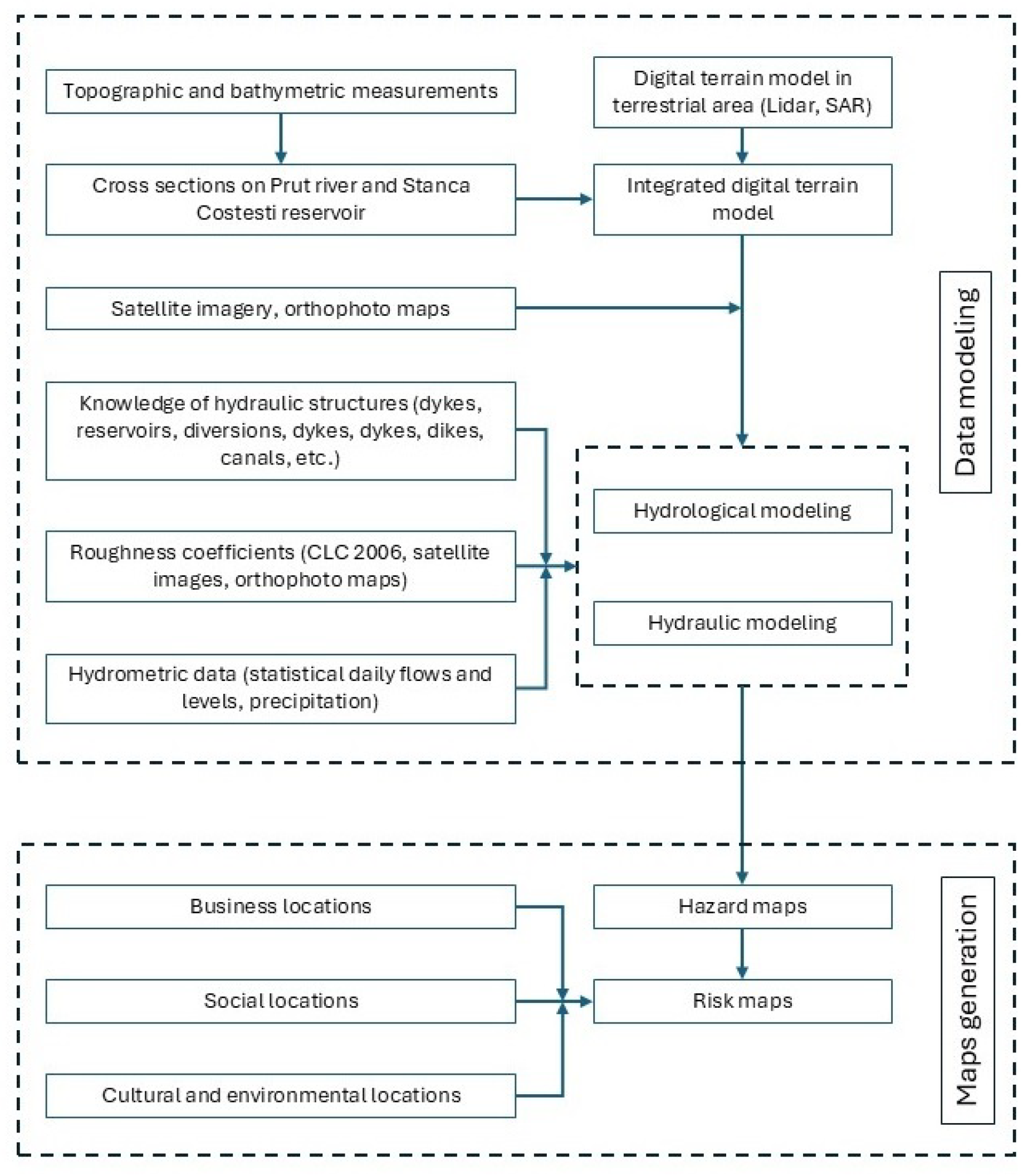
Figure 2.
Extract from the flight plan including the flight line diagram and flight parameters performed to complete/update data from the Stânca-Costești accumulation area.
Figure 2.
Extract from the flight plan including the flight line diagram and flight parameters performed to complete/update data from the Stânca-Costești accumulation area.
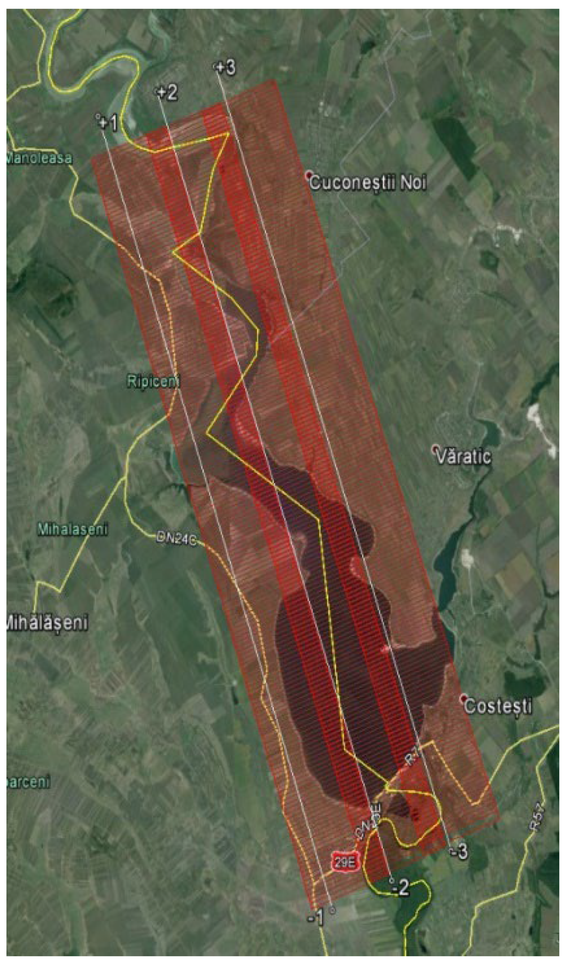
Figure 3.
Flow diagram of common aerial data collection operations.
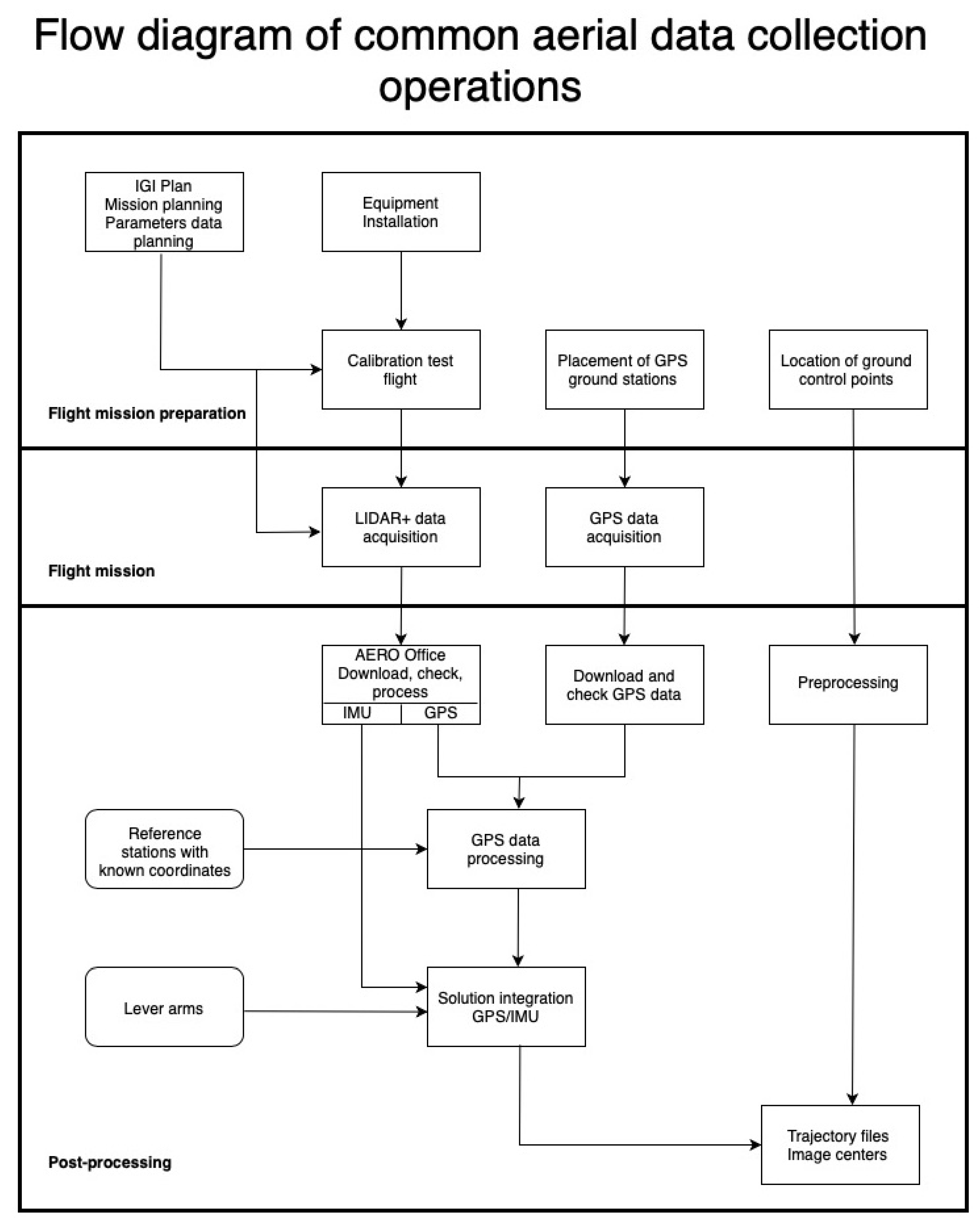
Figure 4.
View of the Stânca-Costești reservoir, a - 2D view in UltraMap OrthoProduction module, b – 3D view.
Figure 4.
View of the Stânca-Costești reservoir, a - 2D view in UltraMap OrthoProduction module, b – 3D view.
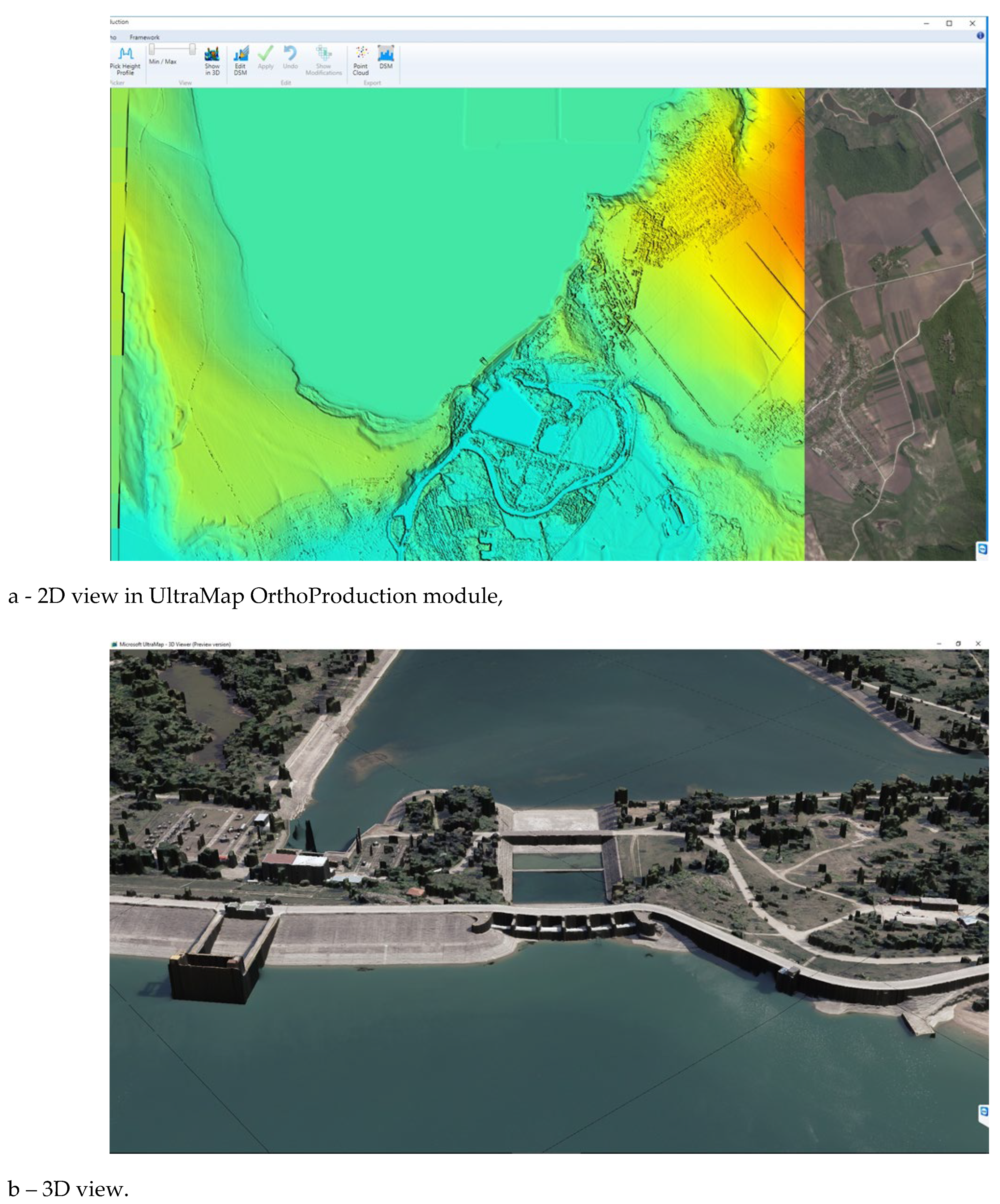
Figure 5.
Workflow Schema of Image Processing Procedures within the ULTRAMAP Program [18]
Figure 5.
Workflow Schema of Image Processing Procedures within the ULTRAMAP Program [18]
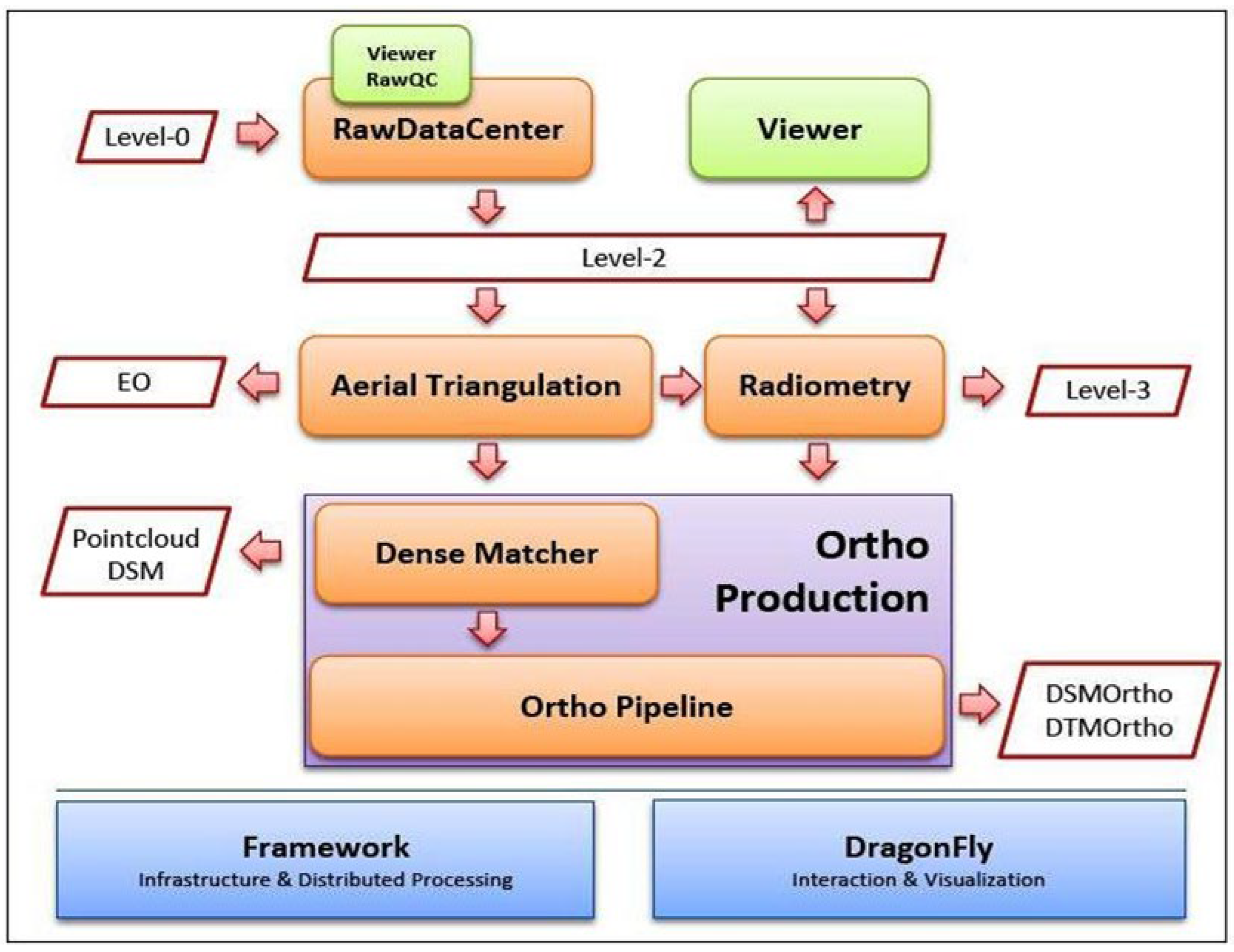
Figure 6.
Figure 6. Example of overlapping of determined points by topographic measurements over MDT
Figure 6.
Figure 6. Example of overlapping of determined points by topographic measurements over MDT
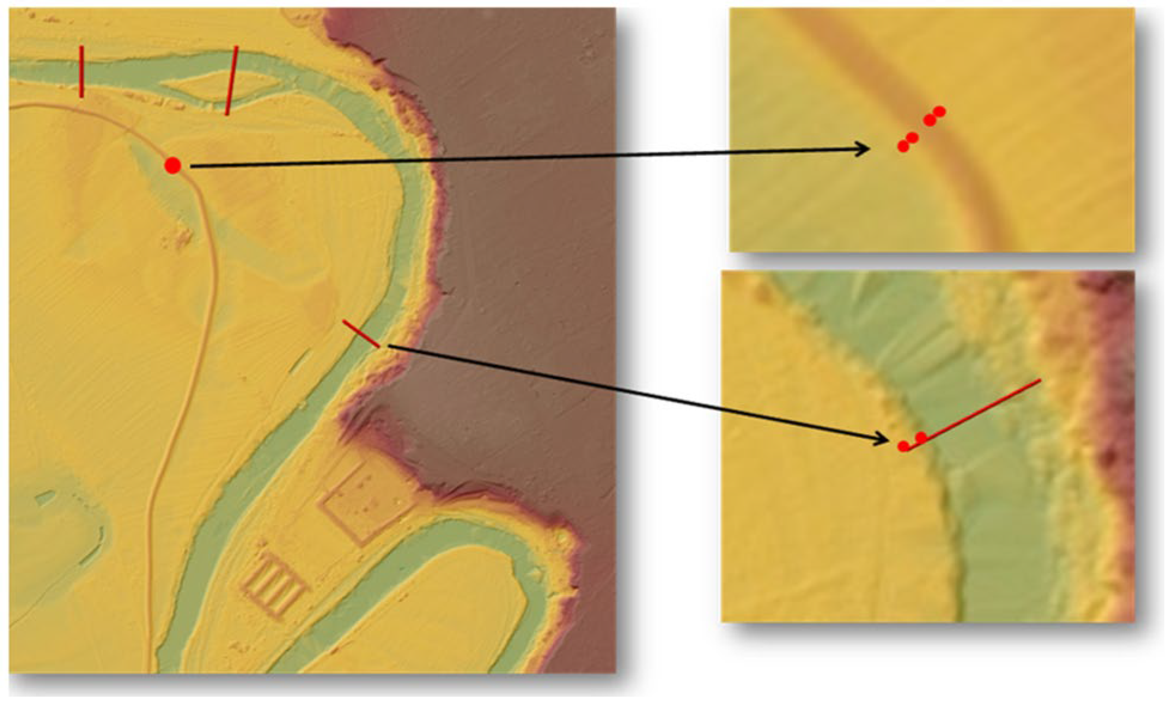
Figure 7.
Example of a flood map +0%.
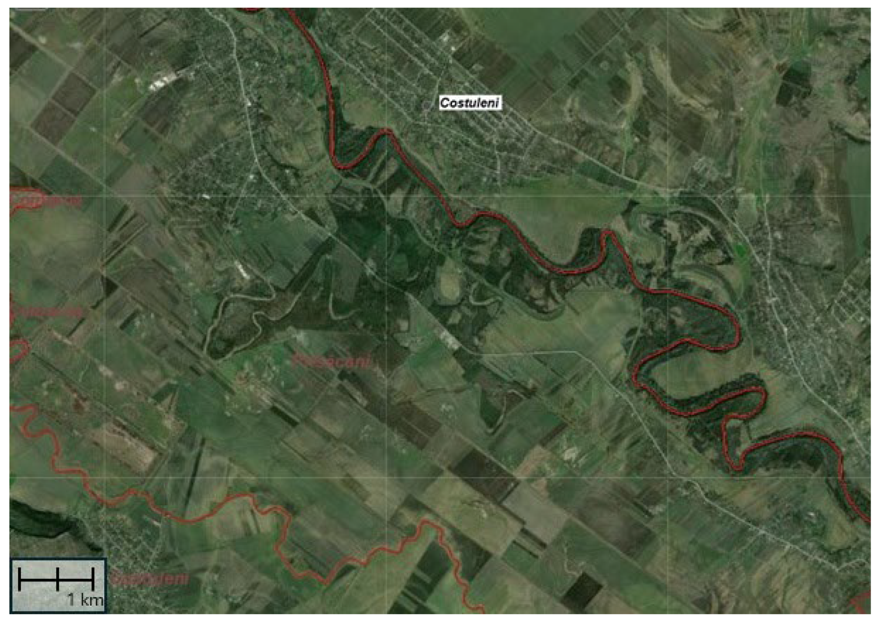
Figure 8.
Example of a flood map +0,5 %.
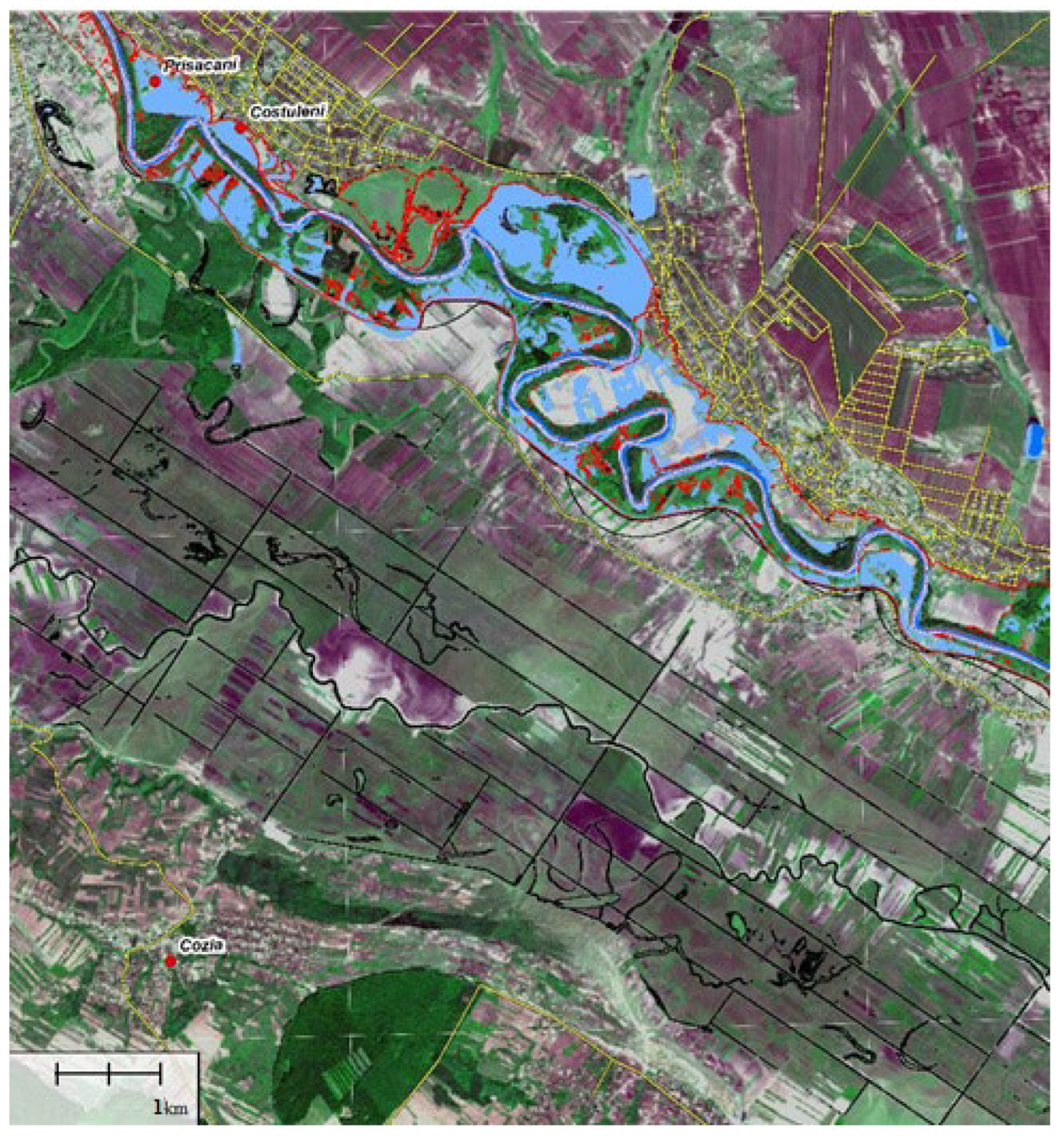
Figure 9.
Flood maps corresponding to maximum flows with exceedance probabilities of 0.1%, 0.5%, 1% and 10% on the Prut River
Figure 9.
Flood maps corresponding to maximum flows with exceedance probabilities of 0.1%, 0.5%, 1% and 10% on the Prut River
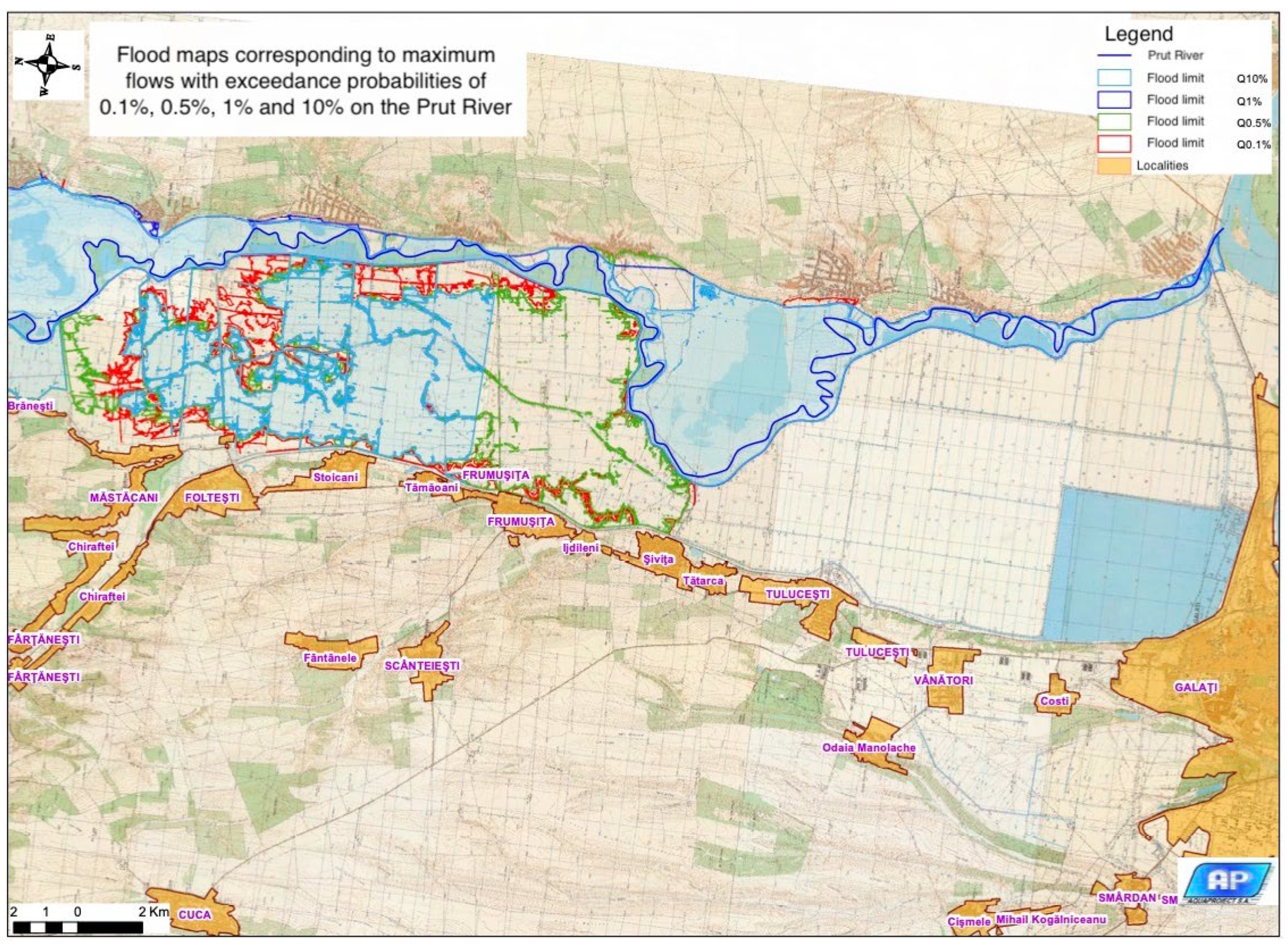

Table 1.
Table with data from the assessment of the accuracy of data from the existing Digital Model.
Table 1.
Table with data from the assessment of the accuracy of data from the existing Digital Model.
| Nr. pct. | X Stereographic 1970 | Y Stereographic 1970 | Z from measurements | Z from the existing Digital model | Z-differences |
|---|---|---|---|---|---|
| 1 | 446166.399 | 749856.371 | 5.177 | 5.191 | 0.014 |
| 2 | 446166.972 | 749122.036 | 5.834 | 5.895 | 0.061 |
| 3 | 446167.195 | 749118.364 | 5.694 | 5.669 | -0.025 |
| 4 | 446462.235 | 748807.676 | 7.657 | 7.647 | -0.010 |
| 5 | 446464.728 | 748812.093 | 7.549 | 7.517 | -0.032 |
| 6 | 448296.490 | 747855.194 | 7.637 | 7.667 | 0.030 |
| 7 | 448297.113 | 747859.075 | 7.605 | 7.457 | -0.148 |
| 8 | 449729.415 | 746928.357 | 8.196 | 7.563 | -0.633 |
| 9 | 450739.187 | 746382.863 | 7.915 | 7.832 | -0.083 |
| 10 | 450741.408 | 746379.560 | 7.979 | 7.841 | -0.138 |
| 11 | 461635.305 | 741140.586 | 8.498 | 7.752 | -0.746 |
| 12 | 462311.121 | 741727.466 | 7.973 | 7.573 | -0.400 |
| 13 | 462311.396 | 741723.993 | 8.036 | 7.732 | -0.304 |
| 14 | 463635.554 | 745686.487 | 9.225 | 8.686 | -0.539 |
| 15 | 463637.353 | 745686.895 | 8.957 | 8.706 | -0.251 |
| 16 | 473769.710 | 745910.468 | 10.989 | 10.523 | -0.466 |
| 17 | 473769.897 | 745915.437 | 11.197 | 10.863 | -0.334 |
| 18 | 487243.490 | 740493.701 | 12.998 | 12.689 | -0.309 |
| 19 | 487247.435 | 740493.219 | 13.049 | 12.652 | -0.397 |
| 20 | 680717.057 | 678520.475 | 49.973 | 50.905 | 0.932 |
| 21 | 708131.935 | 667821.267 | 104.640 | 104.685 | 0.045 |
Table 2.
General flight details.
| Name | Value | Unit |
|---|---|---|
| CCNS4 project name | PRUT | |
| CCNS4 area name | PRUT | |
| Coordinate system | UTM North – WGS84 SPH – EGM96:35 | |
| Sensor name | LM7800 60O 400kHz [Mode 7] | |
| Magnitude Variation | 0 | Deg |
| Minimum side gap | 154 | m |
| Data Annotation 1 | WGS84 | |
| Data Annotation 2 | Alt [ft] |
Table 3.
CCNS4 - Computer Controlled Navigation System Summary
| Name | Value | Unit |
|---|---|---|
| Number segments | 3 | |
| Segments length | 62.090 | Km |
| Operation time | 0.386 | h |
| Time per turn | 120.0 | S |
| Mean speed | 54 | m/s |
| Raw storage | 11.498 | GB |
Table 4.
CCNS4 - Computer Controlled Navigation System Line Parameter Listing
| Flight line name | Segment name | Mean Height above mean sea level [m] | Mean Average Ground Level [m] | Mean Ground Level [m] | Azimuth [deg] | Segment length [km] | Mean dots per area [*/m2] | Eaw storage [GB] |
|---|---|---|---|---|---|---|---|---|
| 1 | 1 | 2242 | 2147 | 95 | 162 | 20.782 | 2.0 | 3.848 |
| 2 | 1 | 2242 | 2157 | 84 | 162 | 20.698 | 2.0 | 3.833 |
| 3 | 1 | 2242 | 2136 | 105 | 162 | 20.610 | 2.0 | 3.817 |
Disclaimer/Publisher’s Note: The statements, opinions and data contained in all publications are solely those of the individual author(s) and contributor(s) and not of MDPI and/or the editor(s). MDPI and/or the editor(s) disclaim responsibility for any injury to people or property resulting from any ideas, methods, instructions or products referred to in the content. |
© 2024 by the authors. Licensee MDPI, Basel, Switzerland. This article is an open access article distributed under the terms and conditions of the Creative Commons Attribution (CC BY) license (http://creativecommons.org/licenses/by/4.0/).
Copyright: This open access article is published under a Creative Commons CC BY 4.0 license, which permit the free download, distribution, and reuse, provided that the author and preprint are cited in any reuse.


