1. Introduction
As a Water Scarcity Area, the ecological construction and sustainable economic development are constrained by water resources in Xinjiang. According to the Xinjiang Water Conservancy Bulletin, water use in Xinjiang mainly consists of agricultural water, industrial water, and ecological water, with a ratio of 91:2:3, but with a benefit ratio of 1:100:2,000, which is a typical "high water consumption and low output"water use structure.Therefore, there is an urgent need to improve the water use structure and optimize the allocation of water resources to increase the efficiency of water use and alleviate water stress in Xinjiang. At present, there are more studies on water resource allocation and water use structure optimization in various river basins in Xinjiang, with the single aim of improving economic or environmental benefits, which is unable to satisfy environmental needs and economic benefits at the same time.
At present, the optimal allocation of water resources models and solution methods have gone through a hierarchical development, from "water on water allocation", "broad water resources allocation" to "quantity and quality of the integrated allocation", from "demand-determined supply", "supply-determined demand" to macroeconomic, sustainable development, etc. [
1,
2].For model solving, a large number of intelligent optimization algorithms such as genetic algorithms [
3,
4], simulated annealing algorithms [
5,
6,
7], particle swarm optimization algorithms [
8,
9,
10], and cuckoo algorithms [
11,
12] are applied.The above algorithms have the advantages of simplicity and high efficiency in solving, but have different disadvantages such as only being able to target a single objective function, or the algorithm selecting parameters that are difficult to determine leading to unsatisfactory solving accuracy.In this research, the economic, social and ecological multi-objective water resources optimization model is established in the Abbey Lake Basin in Xinjiang as an example, and the NSGA-III algorithm is used to obtain the optimal solution set for the problem of constraints that are more difficult to be handled by the multi-objective optimization algorithm, so as to provide a reference for the optimal allocation of resources in the Xinjiang region[
13].
2. Methods and Data
2.1. Methodological Framework
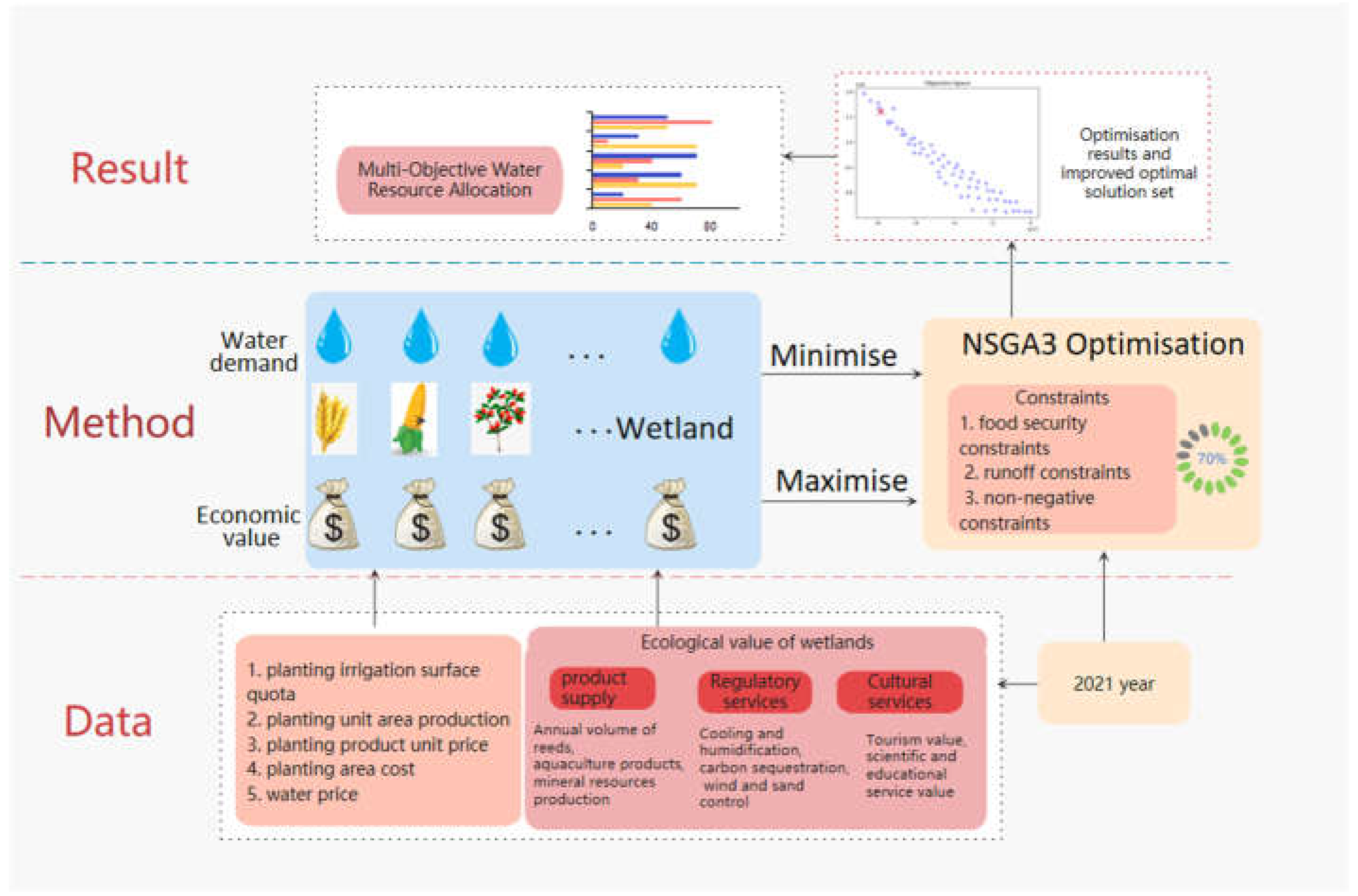
The structural optimization research framework of this paper is shown in
Figure 1. The establishment of the objective function in the figure will involve the main crops such as corn, wheat and other major crops and elements such as irrigation surface quota, unit area yield, planting cost, product price and wetland ecological and economic value. This paper will be based on this to carry out the construction and solution of multi-objective optimization model of agricultural water use, and the actual data and the results of the optimization scheme will be compared and evaluated.
2.2. Optimization Model
The Optimization Model is based on the current status of regional water resource application and the requirements for sustainable development. The optimization model is based on the ecological value of water-food-wetland linkages, weighing economic and ecological benefits, with the objective function of maximizing the net economic benefits and minimizing the amount of water shortages. Constraints include water supply constraints, food security constraints and non-negative constraints.
According to the survey, the river water in the Abbey Lake Basin is used for agricultural irrigation and lake water diversion, and other industrial and domestic water is provided by groundwater, so based on the actuality, the following assumptions are made for the construction of the target equation:
① Factors of production other than water resources are met in all areas that generate economic value;
②The costs invested in the survey, planning, development, utilization and management of river water resources will rationally meet the requirements of the macro-objective of rational allocation and efficient utilization of water resources;
③ In calculating the net benefits of river water resources from economic activities, all factor costs are deducted and the effects of groundwater or mixing of precipitation are not taken into account;
④ The value of ecosystems mainly refers to the value of the service function of ecosystems, and the non-water related portion has been deducted;
⑤ Consider only river water allocation issues, not other water sources.
⑥ On the premise that the ecological value derived from wetlands is only related to the amount of water entering the river.
2.2.1 Objective function
(1) Economic objectives. The economic benefits of water use for different crops are calculated on the basis of irrigation quotas, yields per unit area, unit prices of products and costs per unit area, and the ecological value of the lake is calculated through the value of product supply services, regulatory services and cultural services generated by the use of water(Eq(1)).
i denotes the ith block (WenQuan County=1, Bole City=2, Shuanghe City=3,(not inculde in this research) Jinghe County=4, Abbey Lake Wetland=5), j denotes the jth water use area (agriculture water, forestry water, livestock water, ecological water, etc.),eij denotes the net benefit coefficient of water demand for the jth water use area in region i, xij denotes the amount of water allocated to the jth sector in region I, and aij denotes the water allocation relationship (1 for allocation, 0 for no allocation).
(2) Social objectives. The regional minimum water deficit was selected to meet the social benefits.
2.2.2. Constraints
(1) The total water use of WenQuan County and Bole Cityshall not exceed the total runoff volume (QB) of the Bortala River(Eq(2)).
(2)The total water distribution in Jinghe County shall not exceed the total runoff volume (Qg) of the Jinghe River(Eq(3)):
(3)The total water allocation is less than the total runoff of the two rivers(Eq(4)):
(4)Food security constraints(Eq(5)).
WP is the average human food requirement(person/kg)(Eq(6)):
(5)Non-negative constraint
2.3. Study Area and Data Sources
2.3.1. Overview of the Study Area
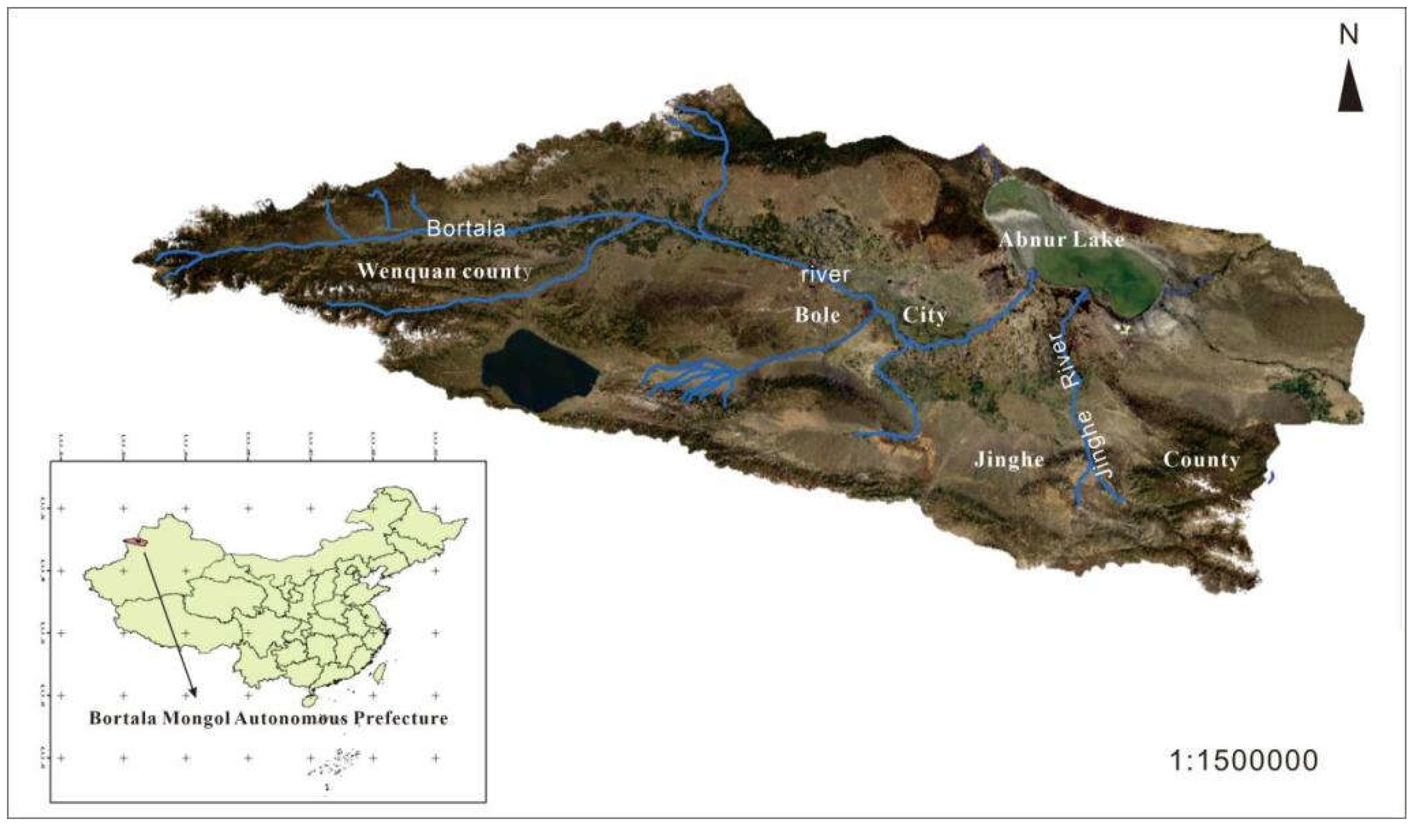
The Abbey Lake Basin is located in the hinterland of the Eurasian continent, including the entire territory of the Jing River Basin, the Boltara River Basin in the Bortala Mongol Autonomous Prefecture and the Kuitun River Basin in the Ili Kazakh Autonomous Prefecture, and the study in this paper is based on the Jing River Basin in the Bortala Mongol Autonomous Prefecture and the Bortala River Basin as examples. Its boundaries start from the oil base Dushanzi and the hub city of Kuitun in the northern border in the east, and from the Borokonu mountainous area in the south to the southern part of Toli County in the north, with a total area of 5.06×10
4km
2 (
Figure 2). it is a typical arid area with the characteristics of a mountainous one-oasis and one-desert ecology, and it is an ecological barrier in the north of our country, and at the same time, it is the western gate to enter and exit our country from the New Asia-Europe Continental Bridge, and it is an important part of the development of the economic belt on the northern slopes of the Tianshan Mountains in Xinjiang Therefore, it holds a crucial strategic position in the geopolitics, regional economy, and ecological and environmental governance of China.This paper takes the administrative area of Bortala Mongol Autonomous Prefecture in the northeastern part of the Abby Lake Basin as an example to carry out relevant research.
2.3.2. Data Sources
(1) Crop eco-efficiency coefficient
The benefit coefficient score of agricultural water use is determined by the gross agricultural product and the corresponding water consumption. Based on years of data related to agricultural cultivation in the study area, the main crops wheat, corn, cotton, beet, wolfberry and sunflower were selected and their net water use benefits were calculated separately(Eq(7)):
Where, ei is water use efficiency, w irrigation surface quota (m3/hm2), p unit area yield (kg/hm2), v product unit price (yuan/kg) c, cost of planting (yuan/hm2), r water price (yuan/m3)
The resulting water efficiency coefficients for domestic and agricultural use in the planning year 2021 are calculated as shown in the
Table 1:
(2) Eco-efficiency coefficient of Abbey Lake
Lake Abby is a closed saltwater lake, and the main water systems into the lake are the Kuitun River, the Bortala River, the Jing River, the Sikeshu River, the Gurtu River and the Daheyanzi River. The historical period of Lake Abbey, was a place where many rivers converge, with the large-scale human activities of soil and water development, after 1979 year , due to the increase in population, economic and social development and urban expansion, resulting in an increase in water consumption, so that the amount of water into the lake year by year to reduce the lake surface gradually shrinking, into the Lake Abbey's largest river - KuiTun River has basically cut off the flow of water, the remaining only the JingHe and Bortala River. The only remaining rivers are the Jing River and the Bortala River, which have surface water entering Lake Abby all year round [
14]. Especially in 2003, the shrinkage intensified, to 2015, shrinking to 362 km
2 , the deepest depth of just over 2m, in order to step up the protection and restoration of the ecological environment of Lake Aibi, from 2015, Bortala state from the Bortala River and the Kuitun River to Aibi Lake diversion of water, in order to maintain the ecological environment around the Aibi Lake, coupled with the recent years of high precipitation, the amount of water into the lake has increased since 2016, the lake surface of the Aibi Lake, and the water supply has increased since 2016, the lake surface of the Aibi Lake, the lake surface of the Aibi Lake, the lake surface of the Aibi Lake. Since 2016, the lake surface of Lake Abby began to recover, until the end of July 2017, the lake surface area of Lake Abby recovered to about 805 km
2 [
15,
16,
17].
Aibi Lake is northwest of the Alashankou and Tori, the average annual number of windy days close to half a year, therefore, in the windy section of the second bridge between Asia and Europe, "Lanxin Line" West, G30 Lianhuo Expressway, Jing A highway often by the wind and sand burial and salt-containing sediment corrosion hazards, threatening the operation of the safety. The unique wetland ecological environment of Abbey Lake is a place for hundreds of species of animals and plants to live and reproduce, and it has its own diversity of biological resources. Among the biological resources, the most important one is Artemiasalina, which is called "soft gold" by people around Lake Ebey [
18]. Lake Ebey is a resource-rich lake. The lake is rich in non-metallic deposits of salt, crude nitrate, magnesium sulfate, boron, bromine and iodine. National first and second class protection of 49 species of wildlife, there are 12 species of state-protected plants Abby Lake Wetland Reserve has a variety of wild plants totaling 66 families 281 genera 579 species, a variety of vertebrates 327 species (including birds), of which there are a large number of national protection of plants and animals to become China's inland arid zones, a unique bio-genetic treasure trove [
19].
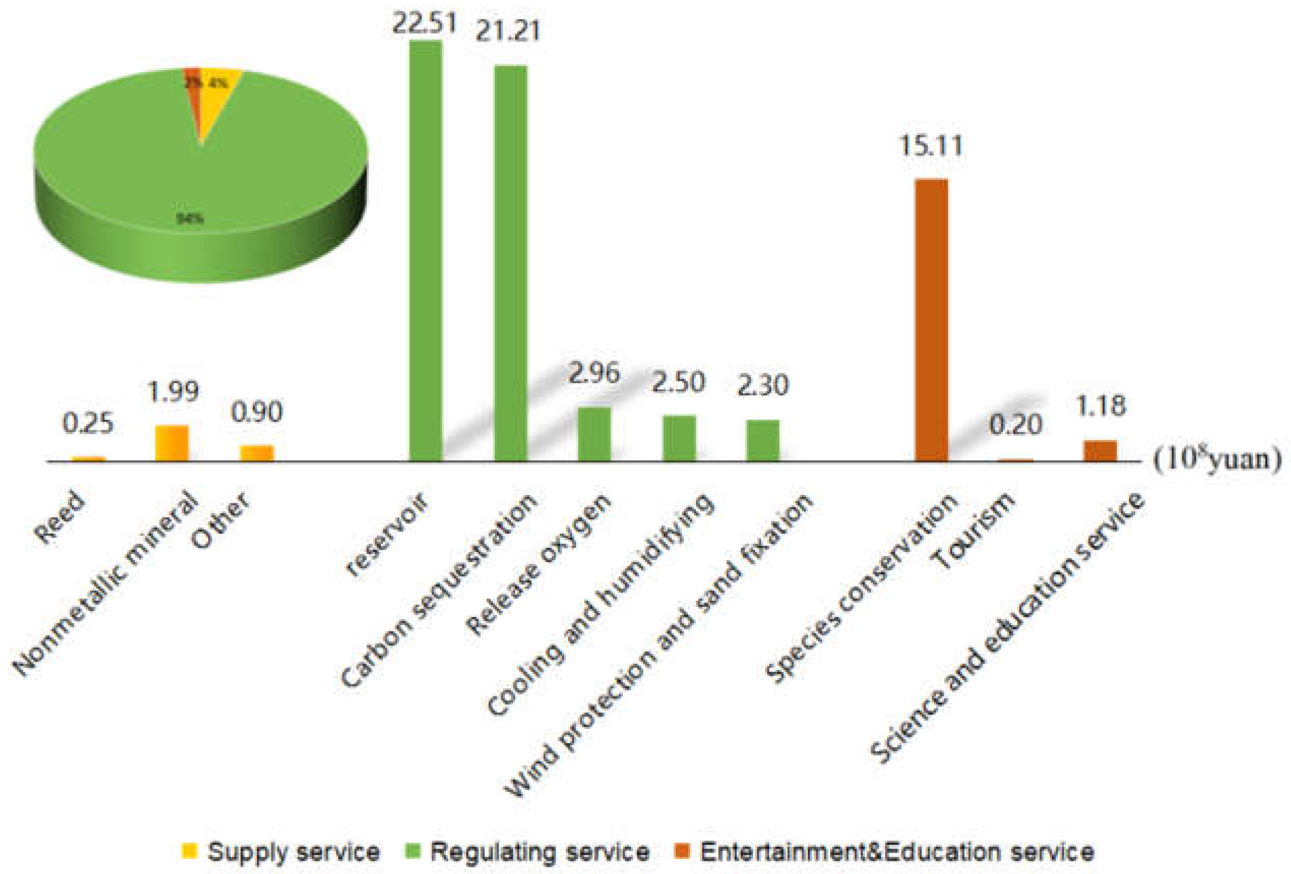
Therefore, Abbey Lake is also a water user of Bortala River and Jing River, and its benefits wetland ecosystem benefits, Abbey Lake wetland value according to its ecosystem function is divided into supply value, regulation value and cultural and recreational value, and is calculated by using the market pricing method, the cost substitution method, and the protection cost method. (
Table 2).
The calculation results are shown in the
Figure 3. According to the calculation results, it can be seen that the regulation service value of Abbey Lake wetland is accounting for 94% of the total ecological and economic value, so the existence of Abbey Lake wetland is very important for the local ecological environment.
The ecological benefit coefficient was calculated in by the following method(Eq(9)).
Eco-efficiency coefficient where:E refers to the value of ecosystem service function; Z refers to the input capital to maintain natural ecological balance; Wmin ecological environment minimum water consumption; B is the apportionment coefficient.
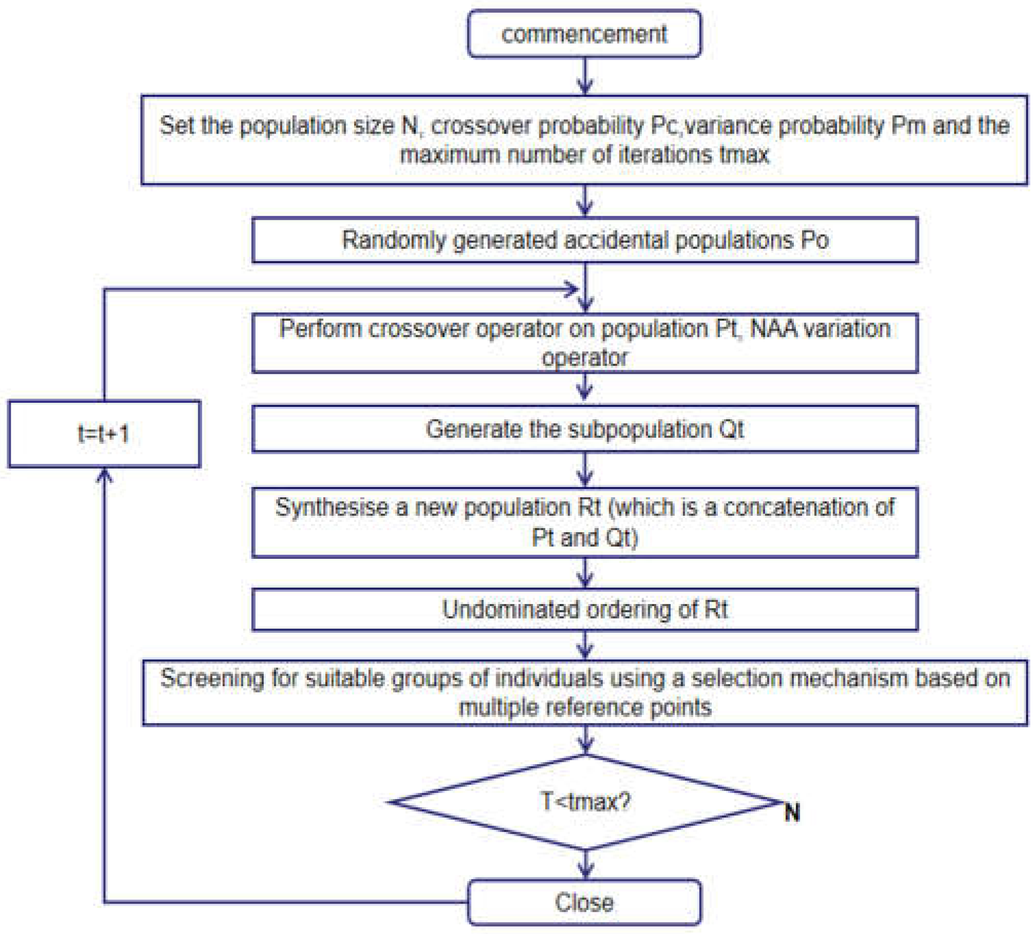
(3)NSGA-III algorithm
NSGA-III is a fast elite non-dominated sorting genetic algorithm for multi-objective optimization proposed by Deb in 2014 [
20]. A reference point mechanism is introduced, where individuals of the population that are non-dominated and close to the reference point are retained, emphasizing that the members of the population are non-dominated and close to the provided reference point. It is mainly used to solve unconstrained and constrained conditions in dealing with super-objective optimization problems to maintain the diversity of the population using well-distributed reference points.
Figure 4.
Flowchart of NSGA-III algorithm.
Figure 4.
Flowchart of NSGA-III algorithm.
3. Results and Analysis
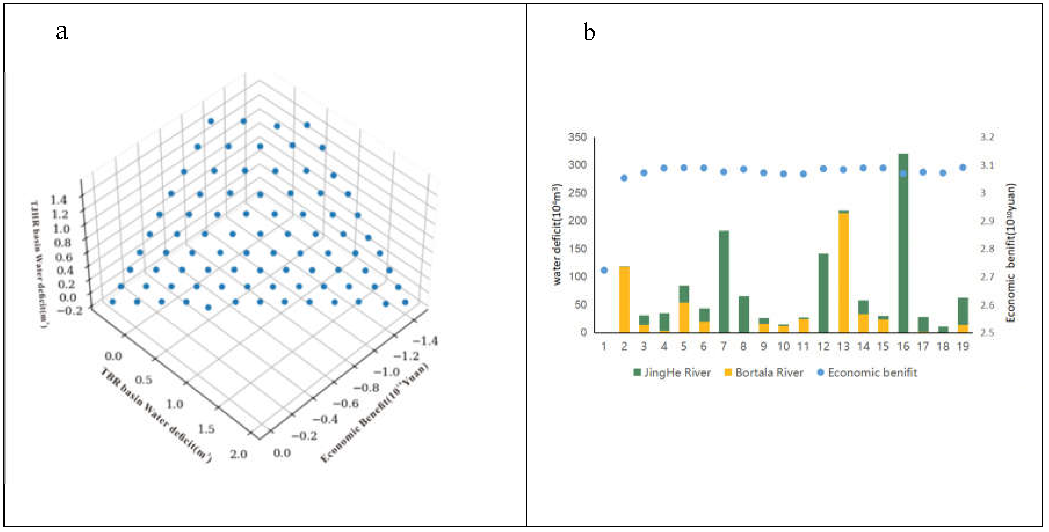
NSGA-III was used to solve the multi-objective optimal allocation problem of water resources in the Abbey Lake Basin (Bortala region), and the mathematical model of multi-objective water resources allocation in the Abbey Lake Basin was coded in python language for this simulation. Where the population size is set to 496 and the number of iterations is set to 800, the simulation generates the Pareto optimal solution set is shown in
Figure 5a.
The optimal allocation results are based on the NSGA-III algorithm to achieve multi-objective coordination, where the decision makers have different needs and require different allocation schemes.The Pareto optimal solution set obtained by the NSGA-III algorithm contains multiple allocation schemes, which produced 18 optimal solutions under the bi-objective constraints (Figure 5b). The selection from the set of Pareto optimal solutions focuses on the one optimal water allocation scheme with the highest economic-ecological benefits, obtaining 3.09×10
10yuan, which is 36.5% higher than the actual benefit. The volume of the water shortage is 301,800 m
3, of which 78.2% of the water shortage in the Bortala River Basin, 21.2% of the water shortage in the Jing River Basin, and 197,447.89 m
3 river water allocated to the lake water, the results of the configuration are shown in
Figure 6, From the figure, it can be seen that under the condition of ensuring food security, the grain water allocation meets the minimum requirement and the wolfberry water resource allocation is the highest, which is also consistent with the actual net water benefits generated(
Table 2).
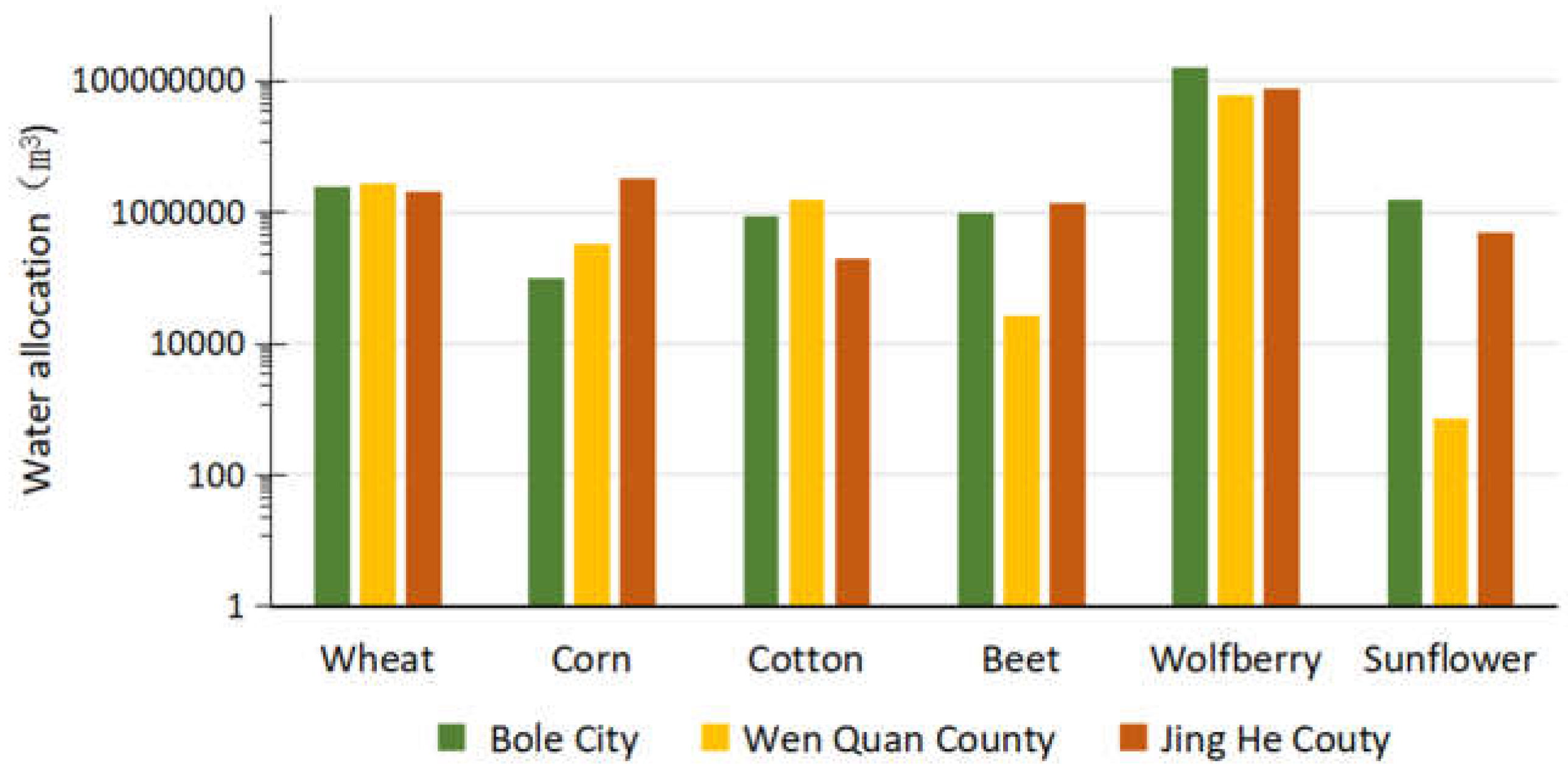
From the Pareto optimal solution set selection focusing on the social shortage of the smallest an optimal water distribution scheme, configuration results are shown in the
Figure 7:The calculations results show that economic-ecological benefits are 2.72×10
10 yuan, the volume of the shortage water is 326.53m
3, of which the Bortala River shortage of 326.40m
3, Jing River 0.1m
3, the water allocation to the lake is 1208,869.56m
3. In this condition the economic-ecological benefits are smaller, but still 20.3% higher than the actual economic value. The water allocation structure is consistent with the allocation method above, with the maximum amount of water allocated to wolfberry while ensuring basic food security conditions.
Li Jiang proposed that there is a functional relationship between the amount of water entering the lake and the lake surface based on the relationship between the area of the lake and the amount of water entering the lake over the years [
21]:
Where: P represents the amount of water entering the lake (108m3), m represents the lake area (km2).
Calculated through the function relationship were obtained lake area of 55.3km
2, 57.1km
2, Abbey Lake wetlands for the local ecological maintenance off vital, the researchers believe that the lake area at least to maintain the lowest area in the history in the 500-600km
2, the appropriate area of 800-850km
2 [
22,
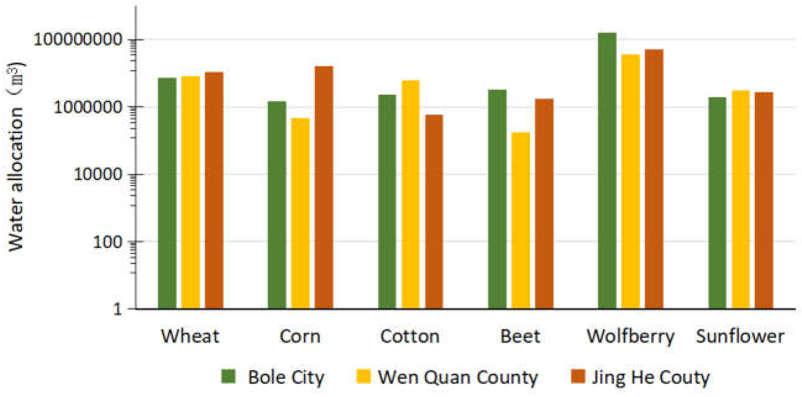
23]. Therefore, the optimization model on the addition of the condition that the area of Lake Abbey is greater than 500km
2 if the security food demand is guaranteed then the calculated value is negative, after lifting this constraint to obtain the optimal solution is: the conomic-ecologica value are l3.8×10
10yuan, the volume of the water shortage is 105,613.25m
3.
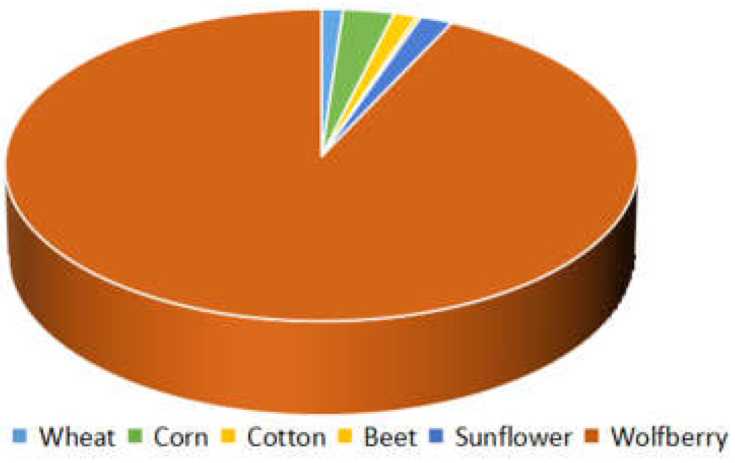
When food security is not taken into account, more than 90% of water resources are allocated to wolfberry, and the value it generates exceeds 70%, which numerically shows that cash crops have greater planting value when other factors are not taken into account (
Figure 8).
4. Conclusions
(1) The adaptive NSGA-III algorithm was used to solve the multi-objective economic-social-ecological water resource allocation model for the Bortala section of the Abbey Lake Basin, and three scenarios focusing on different objectives were set up for decision-making based on the generated Pareto optimal solution to obtain the proposed economic value and social water deficit.
(2) In the case of complete consideration of economic value, the economic-ecological benefits are 3.09×10¹⁰yuan, 36.5% higher than the actual. Under the premise of considering the social benefits, the economic-ecological benefits are 2.72×10¹⁰ yuan, which is 20.3% higher than the actual value, and with the very small volume of the water shortage (326.53m3 ).The results of this study are useful for improving the "high consumption, low efficiency" agricultural structure in the Bortala Basin.
(3) When calculating from the point of view of protecting the ecology of the Abbey Lake wetland, food security cannot be achieved by surface water alone, and it needs to be combined with groundwater in order to obtain a more reasonable result.
(4) In this paper, the optimal allocation of water resources is only based on the annual runoff of the Bortala River and the Jinghe River, without considering seasonality and other issues, and it is necessary to carry out a further step to refine the allocation of water resources under the scenarios of a flat and a low water year. At the same time, other solution methods can be applied and their performance can be compared and analysed to further verify the applicability and effectiveness of the method.
Data Availability Statement
the research raw data from “Xinjiang Statistical Yearbook”.
Acknowledgments
This work was sponsored by The Key Laboratory of Xinjiang Coal Resources Green Mining general educational reform Project (Project Number:KLXGY-Z2406),Also thanks to Prof.Gui Dongwei for providing valuable suggestions.
Conflicts of Interest
The authors declare no conflicts of interest.
References
- WANG Hao, YOU Jinjun. Advancements and development course of research on water resources deployment[J].Journal of Hydraulic Engineering, 2008(10):1168-1175.(in Chinese)).
- ZHAO Yong, PEI Yuansheng, WANG Jianhua.The progress of water resources rational allocation[J].Advances in Science and Technology of Water Resources,2009,29(03):78-84.(in Chinese)).
- ZHENG Hexiang, SHI Haibin, CHAI Jianhua, et al.Optimal irrigation schedule model of.
- forage crop by RAGA-DP under deficit irrigation[J].
- Li Lin, Wu Xinmiao, Du Zhihong, Research on optimal allocation of water resources based on improved NSGA algorithm[J]. Hydropower Energy Sci..2015,33(4): 34-37.
- DU Bailin, ZHANG Jianfeng, GAO Zehai, et al. Optimal allocation of water resources based on simulated annealing particle swarm algorithm [J]. Journal of Irrigation and Drainage Machinery Engineering.2021,39(3):292-299..
- LI Xin,MA Xiaodong. An improved simulated annealingalgorithm for interactive multi-objective land resourcespatial allocation [J]. Ecological Complexity,2018,36:184-195 . [CrossRef]
- WANG Zhanping,TIAN Juncang,FENG Kepeng.Optimalallocation of regional water resources based on simulatedannealing particle swarm optimization algorithm [J]Energy Reports,2022,8:9119-9126 . [CrossRef]
- ZARGHAMI M, HAJYKAZEMIAN H. Urban water resources planning by using a modified particle swarm optimization algorithm[J]. Resources,Conservation and Recycling,2013,70:1-8. [CrossRef]
- WANG Wenjun, FANG Guohua, LI Yuan, et al. Optimal scheduling of water resources in plains slope water area based on improved multi-objective particle swarm algorithm[J]. Water Resources Conservation, 2022,38(2):91-96.
- Mahdi Zarghami, Hassan Hajykazemian. Urban water resources planning by using a modified particle swarm optimization algorithm[J].Resources,Conservation and Recycling,2013,70:1-8 . [CrossRef]
- WANG Yujuan,LUO Jian, XUE Qing, et al. Optimal Allocation of Water Resources Based on Chaotic Gaussian Perturbation Cuckoo Algorithm,2021,39(09):45-49. (in Chinese)).
- LU Xiao,WU Yun,YANG Kan,et al. Water resources allocation based on improved multi-objective cuckoo search[J].China Rural Water and Hydropower,2020(04):56-60. (in Chinese)).
- CHENG Q, DU B, ZHANG L P, et al. ANSGA-III: A Multiobjective Endmember Extraction Algorithm for Hyperspectral Images[J]. IEEE Journal Of Selected Topics in Applied Earth Observations and Remote Sensing,2019,12(2): 700-721 . [CrossRef]
- ZHU S D,ZHANG F,ZHANG Z Y,et al.Hydrogen and Oxygen lsotope Composition and Water QualityEvaluation for Different Water Bodies in the Ebinur Lake Watershed.NorthwesternChina[J].WATER,2019,11(10):2067 . [CrossRef]
- ZHANG Huan, QIU Yubao, ZHENG Zhaojun, et al. Comparative study on the feasibility of seasonal snow de-clouding methods on the Tibetan Plateau based on MODIS[J]. Glacial Permafrost,2016,38(3):714-724.
- Yan Yuna,Che Tao,Li Hongyi,et al.Improving the simulation accuracy of spring snowmelt runoff in mountainous areas using snowpack remote sensing area dataJ]. Glacial permafrost,2016,38(1):211-221.
- Li Xiaolan, Jiang Fengqing, Wang Shaoping, et al. Characteristics of spatial distribution of winter snow depth and density in the city-suburbs of Urumqi from 2011 to 2013[J1.Glacial Permafrost,2015,37(5):1168-1177.
- Gong Yanming. Response of plant diversity to water and salt stress in the Abby Lake Basin [D]. Xinjiang University, 2019.
- Liu Yan. Current situation of biodiversity and protection countermeasures in Aibi Lake Wetland Nature Reserve [J]. Green Science and Technology, 2017.(14): 191-192. [CrossRef]
- Deb K, Jain H. An evolutionary many-objective optimization algorithm using reference-point-based nondominated sorting approach, part i: solving problems.
- Su Xiangming,Liu Zhihui,Wei Tianfeng et al. Response of Abbey Lake area change and its runoff characteristics change [J]. Research on Soil and Water Conservation, 2016, 23 (03): 252-256. [CrossRef]
- Li Jiang, Zhang Zongliang, Yue Chunfang. Reflections on the Evolutionary Characteristics and Ecological Restoration Countermeasures of Aibi Lake [J]. Water Resources Planning and Design, 2023, (01): 75-81+100.
- GUO Shuangshuang, CHU Xinzheng, HU Yuan et al. Discussions on the reasonable water area of Lake Aibi[J]. Journal of Xinjiang Normal University (Natural Science Edition),2012,31(02):16-20. [CrossRef]
|
Disclaimer/Publisher’s Note: The statements, opinions and data contained in all publications are solely those of the individual author(s) and contributor(s) and not of MDPI and/or the editor(s). MDPI and/or the editor(s) disclaim responsibility for any injury to people or property resulting from any ideas, methods, instructions or products referred to in the content. |
© 2024 by the authors. Licensee MDPI, Basel, Switzerland. This article is an open access article distributed under the terms and conditions of the Creative Commons Attribution (CC BY) license (http://creativecommons.org/licenses/by/4.0/).