
Submitted:
24 November 2024
Posted:
25 November 2024
You are already at the latest version
Abstract
The overtopping phenomena and consequent floods cause significant damage to coastal communities. Morphological changes in front of structures during storms can influence their functionality, affecting their stability and leading to failures, impacting the population that are depending on those coastal interventions for their protection. The effect of climate changes, such as the sea level rise and the increase of the storm’s frequency and intensity, can raise the number of overtopping events over defense structures, also increasing coastal morphological changes, challenging future managers, engineers and the scientific coastal communities. A review about morphological changes in front of coastal defense structures and in natural barriers due to overtopping was conducted. The objective of this review is to find and gather relevant information, sometimes disperse, reflecting and grouping the concepts found in the literature. Additionally, the gaps in scientific research are addressed, focusing on the topics that may be enhanced. Several keywords used in the research were presented, emphasizing the relationship between overtopping and models (physical and numerical), storms, defense structures and morphological changes. The results show that there is limited information available, mainly related to morphological changes in front of coastal defense structures during storm events, showing an opportunity to develop knowledge.
Keywords:
Numerical Models
; Physical Modelling
; Coastal Interventions
; Run-up
; Overwash
; Scour
1. Introduction
The coastal areas are dynamic, depending on the forcing agents and sediments dynamics, being influenced by extreme weather conditions, human population growth, settlements and socioeconomic activities [1]. In fact, human population development increased in the last decades in coastal zones and this trend is also expected to continue in the future [2]. Coastal storms and wave overtopping causes substantial human and economic losses, as well as ecologic disturbance and damage [3]. The overtopping and coastal flooding events can be intensified by different drivers [4], such as high tides [5], storm surges [6], heavy rains [7], high river flows [8] and long-term increases in sea-level rise [9]. The overtopping and flooding processes result from the interaction of oceanic and atmospheric processes with the local/regional features, such as topography, nearshore bathymetry, continental shelf and land use. The wave-related processes are the most dominant component of the phenomena. When the waves propagate to shore, a large part of their energy is dissipated by wave breaking but, the remained energy is converted in potential energy in the form of the wave run-up and, when the run-up is higher than the natural or man-made coastal defense structure’s top level, a discharge occurs over the structure and propagates inland [10]. The risk of coastal overtopping/flooding and coastal vulnerability will increase due to the sea level rise and the intensification of the storm events, related to the climate changes [11].
Many populations around the world depend on coastal defense structures to their protection [12]. The hard-engineering structures, such as dikes, seawalls and earthen embankments, are traditional and common mitigation and adaptation measures but, these fixed coastal defense structures present expensive implementation and maintenance requirements [4]. The costs are intensified by the need to repeatedly adjust and expand these structures in response to the increased water levels [13]. Nature-based solutions (NbS) have emerged as alternative solutions, providing multiple benefits for ecosystem and overtopping and flooding protection, including biodiversity and habitat conservation, long-term sustainability, lower maintenance costs, less raw material consumption, applicability at different spatial scales, while being more environmentally friendly [14]. These solutions also offer aesthetic and cultural value, making them appealing options for coastal protection [4]. The combination of NbS with traditional infrastructures or their replacement can be applied to achieve more sustainable and efficient mitigation of flood risks and associated impacts [4].
During storm events, the coastal defense structures are under energetic wave attacks, which may result in overtopping and flooding and the protection they offer can lead to downdrift erosion, and to scouring at the toe of the structures [15], caused by the reflective nature of the defense structures [16,17]. Overtopping mainly occurs during storms, when accurate in-situ field measurements are difficult to obtain [18]. Overtopping has been measured using pre- and post-storm methods, including traditional surveys [19], Lidar surveys [19], and both ground and vertical aerial photographs [20]. Physical and numerical models can help to evaluate the morphological changes near coastal defense structures, affected by overtopping and flooding events.
Development of effective mitigation and adaptation strategies is essential to protect coastal populations and ecosystems. The goal of this work is to provide a state-of-the-art review, centered on morphological changes, caused by overtopping, in front of coastal defense structures, identifying the main knowledge gaps related to the topic. This review article explores the relationship between overtopping and models, overtopping and storms, overtopping and defense structures and overtopping and morphological changes. This review provides a comprehensive and updated overview of the state of the art on overtopping studies and the best practices in coastal management. This document is divided as follows: Chapter 2 presents the temporal evolution of the overtopping studies; in Chapter 3, the methodology to perform the research is defined; Chapter 4 lists the results of the research, according to the defined methodology; in Chapter 5, a discussion comparing former research with recent works is conducted; and finally, in Chapter 6, the main conclusions are presented.
2. Overview on Overtopping Research
The topic of overtopping in coastal dikes gained some importance after the impact of Ise-Wan Typhoon, which causes some damages in Japan, in 1959. In fact, the initial study of this event was performed by Tominaga et al. [21], using a physical model. The authors showed the results of experimental works performed in a wave tank, making comparations with theorical formulations. At the time, the overtopping phenomena required more investigation but could be related to the type of waves in front of the structure. This document is the first article related to coastal overtopping, available in Scopus database.
Historically, overtopping research began with physical modeling and laboratory experiments focusing on simple structures like seawalls, breakwaters, and dikes. For instance, the study of Shankar & Jayaratne [22] evaluated the experimental results of wave run-up and overtopping on smooth and rough slopes of coastal structures. The key factors that influence the wave run-up and overtopping rates include wave height, period, steepness, surf similarity parameter, roughness, layer thickness, and porosity. The results showed that the wave steepness decreases the wave run-up, particularly in impermeable structures models. Permeable slopes reduce wave run-up due to energy dissipation by wave breaking and the roughness and porosity of the armor layers. The overtopping rate is linked to wave run-up through an exponential function, with a strong correlation observed between overtopping energy transfer and relative wall height for smooth slopes. The roughness had a significant impact, with the roughness influence factor ranging from 1.0 to 0.45. The layer thickness also affected run-up, but no clear correlation was observed between run-up and porosity, for permeable slopes. These findings enhance the understanding of how various design parameters influence the effectiveness of coastal defense structures.
With the advance of computational resources, numerical models have been adopted to investigate wave overtopping and wave impact loads at sea defenses. Ravindar et al. [23] numerically simulated a 1:1 quasi-prototype recurved seawall experiment using the OpenFOAM model, an open-source mesh-based code, aiming to model breaking wave impacts on coastal structures at a large scale. By using numerical simulations, the study addresses the limitations of costly and time-consuming large-scale testing by extending the model to test various structures like plain parapets and vertical walls. The numerical model was validated by comparing wave elevation and impact pressures from the simulation with experimental results across three wave-breaking scenarios. Deviations were noted, particularly for cases with shorter wave periods and higher recurved exit angles. The validated model was then used to simulate impacts on plain parapets and vertical walls. It was found that recurved parapets are most effective in reducing overtopping, while plain parapets could be suitable where water droplet dissipation is acceptable. Numerical modeling offers advantages in visualizing complex wave interactions, such as air entrapment and water velocity, which are difficult to capture in physical experiments.
Recent developments have focused on incorporating Machine Learning (ML) algorithms to enhance simulation accuracy. The combination of improvements in computational power, availability of high-resolution datasets, and efficient computational algorithms, allows the development of data driven for predicting wave overtopping characteristics. The use of ML algorithms, where the algorithm learns complex non-linear patterns from datasets to map input features to an output quantity, has gained interest in the coastal engineering community. The study of Habib et al. [24], explores the use of advanced machine learning (ML) techniques for predicting waves overtopping at vertical seawalls. It developed four ML algorithms—Random Forest (RF), Gradient Boosting Decision Trees (GBDT), Support Vector Regression (SVR), and Artificial Neural Networks (ANN)—and applied them to a large dataset from EurOtop [25]. Results show that the RF algorithm outperformed the others, achieving the highest accuracy with an R² value of 0.84 and the lowest residual errors, followed closely by GBDT and SVR. The ANN model showed the lowest accuracy. RF and GBDT also performed better in terms of computational efficiency, completing tasks faster than SVR and ANN. A key finding is that the water depth at the toe of the structure and crest freeboard were the most important factors for predicting overtopping, which aligns with the physical processes involved. The study demonstrated that ML algorithms, especially RF and GBDT, offer more accurate overtopping predictions than traditional empirical methods. A notable advantage of the ML models is their ability to better understand and predict complex relationships, such as the overtopping rate’s dependence on the crest freeboard-to-wave height ratio (Rc/). This underscores the ML models' capacity to more accurately mimic the physical phenomena of overtopping compared to conventional methods. The study concludes that although ANNs are often favored in overtopping predictions, RF and GBDT offer greater accuracy and flexibility, particularly for structures with complex geometries. However, limitations such as missing data and model validation for varying training parameters remain challenges.
These tools allow for better handling of the complex, non-linear relationships between wave dynamics and coastal defenses. Additionally, ML techniques are increasingly used for predicting overtopping discharges, contributing significantly to the modern research landscape. Studies that investigate the overtopping and the response of the coastal defense structures can be found in bibliography, also including the response of the coastal zones to interventions. For instance, Jin et al. [26] used a numerical model to simulate overtopping of coastal structures in shallow water conditions. The model is validated against experimental data and found to be accurate and efficient. The study then investigates how overtopping is affected by different climate scenarios. The results provide valuable insights for adapting coastal protection structures to changing climate conditions.
Lima et al. [27] propose a methodology to evaluate the costs of overtopping and flooding in coastal areas. It combines wave run-up estimation, overtopping event analysis, and flooding damage costs. The methodology involves several steps, including defining a reference scenario, collecting past damage data, and forecasting future costs. The work analyzes a case study on the Portuguese northwest coast (Furadouro beach) using data from the Portuguese Environment Agency. It considers 10 future scenarios to assess climate change impacts and structural changes. A sensitivity analysis is also performed to evaluate the influence of economic parameters. The results show that climate change impacts can significantly increase overtopping costs. However, structural changes, such as extending the slope or increasing the crest level, can mitigate these costs. The study emphasizes the importance of considering flooding damage costs in coastal structure design. The authors conclude that there are uncertainties associated with cost quantification due to limited data. Further research is needed to improve cost estimation. Additionally, the study highlights the need for integrated coastal zone management to address erosion and climate change impacts effectively.
The study of Yuan et al. [28] investigates the overtopping of a seawall under focused wave conditions with wind. It uses a high-accuracy two-phase flow solver to model the complex interactions between waves, wind, and the seawall. The study examines the influence of significant wave height, wind speed, and water depth on overtopping. The key findings include that the wind can increase wave steepness and breaking, leading to larger overtopping volumes. The impact of wind on overtopping depends on wind speed. For low wind speeds, the impact is negligible. However, for higher wind speeds, overtopping volume and run-up height increase significantly. The overtopping volume increases with the wave steepness. The water depth, h, also affects overtopping. For shallow water depths, overtopping is minimal. As h increases, overtopping volume and run-up height also increase. The study has limitations, such as focusing only on unidirectional waves and using small-scale modeling. Future studies will address these limitations. Overall, the study provides valuable insights into the overtopping process of seawalls under combined wind and wave conditions. The research results can contribute to improving coastal infrastructure design and protection.
Another example is given by Blenkinsopp et al. [29], who demonstrates that 2D scanning Lidar can effectively capture wave overtopping of porous dynamic coastal structures. Two analysis methods were used to estimate overtopping volumes, with good agreement between them. The EurOtop parameterization for assessing overtopping discharge provides reasonable estimates, but an appropriate friction factor is crucial. The friction factor was found to be smaller for rounded cobbles compared to angular ones, possibly due to higher infiltration rates. The study also provides estimates of infiltration rates into cobble beaches, which are significantly higher than those on sandy beaches. The ability to capture the time-variation of the entire overtopping volume allows for the measurement of the cross-shore distribution of overtopping discharge. The study finds that overtopping discharge decays rapidly landward due to the porous nature of the structure and can be described using a power law function. This information is valuable for the design of porous structures to reduce inundation and safety concerns.
3. Methodology
Considering the research challenges, a literature review was conducted. The Scopus database (https://www.scopus.com/search/form.uri?display=basic#basic) was chosen to achieve the objective of the work. The Scopus database quickly finds relevant and authoritative research, identified experts and have access to reliable data, metrics and analytical tools. Many documents are available in this database, including over 97.3 M records; over more 28 300 active serial titles and over more 386 000 books. An initial search was performed in Scopus database, using the initial keywords “Coastal AND Overtopping” to limit the research to overtopping in coastal areas and exclude the overtopping related to other sources. Then, additional keywords were used to refine the research in a second level of detail, distinguishing between “Model”, “Storm”, “Defense Structures” and “Morphological Changes”. After that, a third level of detail was performed, dividing the subtopic “Model” in “Numerical” and “Physical” and the subtopics “Defense Structures” and “Morphological Changes” in “Natural” and “Artificial”. These keywords allow the division of the global overtopping topic in different related subtopics. The Scopus database was also used to quantify the number of documents available for each topic and to identify the authors who made more contributions to the subject. It is important to refer that, despite the existence of documents published in 2024, the research only includes documents until 2023, to have data from complete years. The information collected was summarized in Table 1, available in section 4.1. Considering the keywords defined, the evolution of the number of documents available under each keyword was graphically represented, from the initial year of available data (1967) to the end of the research period (2023). This allows us to better understand which topics have been more extensively explored over the years, and the relative importance of each topic. Figure 1 shows the overtime evolution in the number of publications related to overtopping, also available in section 4.1.
Section 4 presents the obtained results related to the overtopping research, highlighting the relationships between overtopping and the other keywords, namely models (physical and numerical), storms, defense structures and morphological changes. It includes studies from authors who have made significant contributions to these topics. The model’s section 4.2, especially the numerical models (section 4.2.1.) was approached differently, as some available numerical models that include overtopping in their simulations were identified. For those, the number of documents (N) available on Scopus database (up to 2023) was quantified, using “Coastal AND Overtopping AND Model AND Name_of_the_Model” keywords to refine the research (Figure 2). Afterward, the models that include morphological changes in their simulations were summarized in Table 2, and some characteristics of the models were compared.
In section 4.3., some definitions of storms and overtopping are listed, because these definitions depend on the documents and the specificities of the study areas considered. Table 3 (section 4.3.) presents some coastal interventions available to reduce overtopping, divided into “soft”, that represents nature base interventions and “hard”, representing engineering structures. Table 3 shows the advantages and disadvantages of both type of interventions.
Based on the applied research methodology, a literature review of the identified publications was performed, and the main results are presented in the following section.
4. Results
Several references were consulted to evaluate the state-of-the-art in overtopping research, highlighting the evolution of overtopping research and the relationship between overtopping and other related keywords, as models, storms, defense structures and morphological changes.
4.1. Evolution on Overtopping Research
To evaluate the evolution on overtopping research, the number of documents (articles, book chapters, proceeding papers, etc.) and the author most cited are present in Table 1. This information represents the basis for this review research, limiting the quantity of documents to analyze the research on the morphological changes in front of coastal structures, due to overtopping.
In Table 1, it is observed that, out of 4044 documents related to overtopping, the largest contribution comes from works related to “Model” (3432 documents available) and almost half of the identified documents are related to storm events (1919), showing the relationship between overtopping and models, that are important tools used to study the phenomena and the relationship between overtopping and storms, that shows that, storm conditions contribute to the occurrence of overtopping events.
For “Defense Structures” and “Morphological Changed” keywords, fewer documents are available, representing an area of engineering that is less studied when related to coastal overtopping. Modelling of overtopping can be performed using physical and numerical models and, there are more documents that studied overtopping applying numerical models (2394 documents) than considering physical models (1958 documents). This trend can be explained by the easier ability to define the wave characteristics, structures and scenarios, taking less time to perform the simulations, applying numerical models. Also, with the advance of technology, more and more numerical models are able to simulate overtopping, contributing to the increased research and publications.
The “Defense Structures” keyword was also divided into two sublevels of research. There are more documents identified when the “Natural” keyword was used (118 documents) than when “Artificial” keyword was used (74 documents). In this case, “Natural” includes not only dunes and beaches but also mangroves and saltmarshes, that are considered to work as a natural defense structure. The “Natural” coastal defense structures or nature-based solutions gain more significance in last years, which can justify the increased number of documents. Finally, the “Morphological Changes” keyword presents a similar result to the “Defense Structures”, with more documents when the search is related to “Natural” (156 documents) than when “Artificial” keyword was used (67 documents). Morphological changes are easier to study in natural systems, with dunes, for instance, than in artificialized ones, because of the capability to observe and measure the scale of erosion after overtopping.
The quantity of publications related to overtopping thought time is presented in Figure 1, in accordance with the keywords shown in Table 1. The topic of overtopping (Figure 1, red line) was first published in 1967 [21]. After that, an increase in publications related to the topic was observed, and in 2023, 345 documents were published. This analysis represents an increased awareness related to the overtopping problem from the coastal community, and consequent interest of the research community.
Looking at a more specific level, “Model” is the most published topic (Figure 1, orange line), starting in 1970, with 1 document, and ending in 2023 with 308 documents (time range of analysis). “Storm” was the second topic most published (Figure 1, green line), with 1 document available in 1970 and 196 documents in 2023. These searched keywords show the mainly explored areas related to overtopping. Awareness about “Storm” impacts, vulnerability and exposure of coastal areas and increasing intensity and frequency of storms related to climate changes, may justify the increasing number of publications, while the increasing number of documents related to “Model” represents the advancements in technology or laboratory methods, and the capability to perform simulations in a controlled environment.
The topic of “Defense Structures” began to be published in 1994 (1 document), and in 2023, the number reaches to 20 documents (Figure 1, dark green line). This does not represent that the topic was not studied earlier, as eventual specific types of coastal defense structure may be used as a keyword, instead of the generic “Defense Structures”. Finally, “Morphological Changes” were firstly published in 1996 (1 document) and in 2023, 28 documents were available. The reduced number of publications on “Morphological Changes” open an opportunity to scientists and engineers to develop work in this area of research, because morphological changes in front of coastal defense structures affect their stability, causing structure damage and promoting more overtopping due to the water depths (higher waves can propagate up to the structure). In natural beaches, morphological changes increase the coastal vulnerability of the principal coastal protection structure (dunes, for instance).
4.2. Models
The overtopping phenomena can be studied by considering both numerical and physical models. This section presents the main results, including a brief description of the identified numerical models that are able to reproduce morphological changes.
4.2.1. Numerical Models
In recent years, some numerical models were developed to study overtopping and flooding events. Lara, J. L. is the author that presents more published documents related to the topic of “Model” and “Numerical” (39 documents), due to the work developed with the IH2VOF, in IH Cantabria, Spain [30,31,32,33]. The numerical models that include overtopping in their simulations are presented in Figure 2, organized by the number of publications available on Scopus database after “Name_of_the_Model” being used to refine the previous search of “Coastal AND Overtopping AND Model”.
For the research performed, most of the published documents considered the SWASH (738 documents), the SWAN (313 documents), the OpenFoam (238 documents), and the XBeach (215 documents) numerical models. The other models present less than 100 documents available, applied to studies related do overtopping. Considering the identified models, the following step was to understand which models include the capacity to simulate morphological changes in their simulations, by analyzing the model’s manuals. Those models are summarized in Table 2, which also includes the number of documents (N) available in Scopus database after search for “Coastal AND Overtopping”, “Model”, “Morphological Changes” and “Name_of_the_Model”.
From the 738 documents initially identified for SWASH model, only 122 includes morphological changes in their studies, while for the XBeach model, from the 215 documents identified, only 64 focus on morphological changes. For the other models, less than 10 documents are identified in Scopus database, when the scope is morphological changes. Some capacities of the models presented in Table 2 are described, focusing on the special and temporal scale of the model, the sediment transport and/or bathymetry changes, consideration of overtopping or flooding and the presence or absence of vegetation and/or structures.
SWASH [34] was designed for simulating non-hydrostatic, free-surface and rotation flows and transport phenomena in 1D, 2D and 3D, covering a large range of coastal and oceanic applications, and is useful for spatial scales from centimeters to kilometers and temporal scales from seconds to hours. Coastal processes include wave propagation, simulating shoaling, refraction, diffraction and breaking. Other simulated processes are: wave-wave and wave-current interactions; wave run-up/run-down; shoreline movement; wave interaction with structures; turbulence; wave-damping promoted by aquatic vegetation; wind; transport of suspended load for (non)cohesive sediment and others. The vertical run-up heights are computed with respect to still water levels. The shoreline movement is determined by ensuring non-negative water depths, avoiding complex drying and flooding algorithms. The model can simulate porous structures by defining porosity and structure heights, considering the bottom elevation, vegetation density and structure heigh. The effects of aquatic vegetation on wave damping and the porosity in coastal structures are simulated by SWASH, allowing for partial reflection and transmission of waves through porous materials. The wind and pressure fields are used to simulate storm surges and wind-driven flows, specifying wind speed, direction and drag. For sediment transport function, only suspended sediment is modeled, excluding the bedload. Also, no sediment exchanges between the bed and the flow are considered in the depth average mode.
XBeach model [37] was developed to simulate hydrodynamic and morphodynamic processes along sandy coasts, considering a spatial domain of kilometers and a time scale focused on storm events. It solves processes related to wave transformation (generation, propagation, shoaling, breaking, refraction and dissipation), wave-induced currents, overwash and inundation. Morphological processes include sediment transport (both suspended and bedload, to account for erosion and deposition in the coastline), dune face avalanching and breaking (model simulates dune collapse and breaking events during high energy conditions) and bottom changes (model updates the seabed and coastal morphology based on sediment transport and hydrodynamics). The model considers 1D and 2D simulations, focused on cross-shore processes and simulates different coastal regions with different shapes, respectively. Vegetation, wind and structures can be implemented in XBeach: vegetation, like mangroves, is an additional dissipation mechanism for both short and long waves and the effect is modeled based on vegetation properties, such as height and density (multiple vegetation species can be defined to simulate the interaction between vegetation and flow); the model can also simulate flow resistance in coral canopies and other porous environments by incorporating the canopy’s porosity and height into the momentum equations, defined in a similar way to the vegetation; wind is incorporated as a forcing term in the momentum equations, allowing for the simulations of wind driven processes (storm surges); structures in the model are defined as a non-erodible layer, with a similar format as the bathymetry file.
MIKE 21 model [43] is designed for coastal, oceanographic and estuarine applications. The model uses a flexible mesh approach, allowing detailed simulations of flow and transport phenomena (2D). The model comprises several modules, that can be applied for specific environmental processes: hydrodynamic module, for simulating water movement, accounting with wind, tides and currents; transport module, for representing the movement of dissolved substances or particles in water; particle tracking module, that includes the movement of individual particles, applied for understanding pollutant dispersion or sediment transport; mud and sand transport modules, designed for simulation the movement of sediments in aquatic environments; and others. The bathymetry is corrected in space and time, allowing realistic simulations where the seafloor or riverbed changes. MIKE 21 can simulate areas with flooding and drying, such as coastal floodplains or tidal zones, destining between wet, partially dry and dry grid elements, based on water depth limits. Wind can be modeled in different formats, constant over time or varying in space and time, but model considers the wind to induce surface stress on the water body. Vegetation is modelled using zones, using constant properties, rigid or flexible plants: for rigid plants, model simulates stems or cylinders that exert drag on the water flow; for flexible plants, model accounts for plant elasticity and allows for height changes due to flow conditions, capturing more dynamic vegetation responses. The influence of infrastructures and structures can also be modeled by MIKE 21: infrastructures, like roads, buildings and flood defenses; and structures like weirs, dikes, gates, culverts, and piers are counting in this model. The sand and mud transport can be modeled by MIKE 21, but also allows fluid mixtures, such oil or debris flows, with high concentrations of fine particles, like silt and clay.
The COAST2D model [49] is a 2D, depth integrated, and wave phase-averaged model, that computes the hydrodynamic (waves and currents induced by waves and tides, wave refraction/diffraction, breaking, tides, turbulence and bedform-enhanced bottom friction, and also wave-current interactions) and the morphodynamic (sediment transport rates, including both suspended and bedload transport, the resulting bed level changes, and it’s possible to include different sediment sizes along the domain) in a coupled way. The work of Du et al. [57] presents the integration of a wave overtopping module into the COAST2D. The hydrodynamic of the model was validated against large-scale laboratory experiments showing good agreement between computed velocities and measures for overtopping and non-overtopping cases. The wave overtopping was implemented in COAST2D model, focusing on estimating phase-averaged wave overtopping discharge at nearshore structures. This model was applied to shore-parallel breakwaters, but adaptable to other coastal defense structures. The overtopping discharge was influenced by the geometry of the structure, the wave conditions (significant wave height, wave period, and wave attack angle), the height of the freeboard, the front slope and roughness of the structure, and the water depth at the structure’s toe. The model shows that wave overtopping significantly affects nearshore circulations around breakwaters, especially during storm events. Morphological changes bed tests confirm that wave overtopping alters predictions of morphological changes in the nearshore environment. The wave overtopping has a notable impact on sediment transport patterns, particularly in the gaps between high-crested breakwaters and behind low-crested breakwaters during storms, significantly affecting morphological changes. The study highlights that wave overtopping is crucial for accurately predicting nearshore morphodynamics and shoreline changes, especially in areas with coastal defense structures.
FUNWAVE [45] key aspects are also identified: model is capable of simulate both 1D and 2D wave dynamics; model includes wave generation, wave absorption, wave reflection and wave breaking; the wave run-up and run-down is calculated in the entire computational domain as an active fluid, instead of explicitly tracking moving boundaries; and model uses the slot technique to simulate moving shorelines that involve replacing the solid bottom with a porous seabed for represent the water level being below the beach elevation, creating a more realistic coastal interaction without complex boundary tracking. In Shi et al. [58], a new version of the FUNWAVE model was developed: improving the numerical scheme (the equations were reorganized to facilitate a hybrid numerical scheme); the wave breaking (by switching to nonlinear shallow water equations when the Froude number exceeds a certain threshold, making the process more robust); the wetting-drying method (replaces the previous slot method to better simulate moving shorelines and coastal inundation); the code was parallelized (with non-blocking communication, improving computational efficiency); and tests were done to verify the model's capability to simulate wave shoaling, breaking, and nearshore circulation (advantages from the previous versions includes adaptative time stepping, a shock-capturing scheme to improved wave-breaking modelling and numerical stability and better representation of the swash zone and inundation). The most recent developments include ship-wake generation [59], meteo-tsunami generation [60], and sediment transport and morphological changes [61]. The capabilities of the model includes: nearshore wave propagation and transformation; refraction, diffraction, reflection and nonlinear shoaling; wave-induced nearshore circulation; nonlinear wave–wave and wave–current interactions; wave breaking with run-up and overtopping; partially absorbing/reflecting inner boundaries; harbor resonance and infragravity waves; vessel–generated waves and related sediment transport with morphology change and adaptive mesh refinement module for refined moving and two–wave coupled grids.
In addition to the identified models, it is also referred to as the CS-Model and the IH2VOF, due to their recognized capacity to simulate overtopping. The first one allows changes in the beach profile while the second allows different configurations of the coastal structures. Larson et al. [56] presents the background equations of CS-Model. CS-Model is a simple model for simulating profile evolution at decadal scale. The model considers processes related to dune erosion and overwash due to wave impact, bar-berm material exchange, which means accretion or erosion of beach berm, and aeolian sediment transport, for dune recover. It considers a simple shape to represent the beach profile and the mass conservation, which means that do not have sediment removed and accreted to the system. IH2VOF [47] is a 2D model useful to evaluate the hydrodynamics, stability, and functionality of conventional and non-conventional coastal structures. The model includes realistic wave generation, second-order wave generation, and active wave absorption to simulate various coastal structures like rubble mound, vertical, or mixed breakwaters. The model allows us to characterize all types of porous structures, like berms, core, and porous beaches using the porosity, the mean size of the rocks and friction coefficients. The processes of the model include run-up on slopes (breakwater or beaches) and overtopping processes. The vegetation impact cannot be modelled, but it is under development. Morphological changes are not included in the simulations. The model validation included low-crested structures, vertical breakwaters, rubble-mound breakwaters, wave breaking on gravel slopes, wave transformation on real/natural beaches, long wave transformation and evolution and tsunami wave evolution.
4.2.2. Physical Models
To understand the present state-of-art of physical simulation of overtopping, some published works are briefly described, considering the highly cited author presented in Table 1, Altomare, C., with 29 documents.
The study of Chen et al. [62] developed an empirical formula to predict overtopping flow load based on overtopping momentum flux. The formula was verified using experimental data and shows good accuracy. Other parameters determined by the experience includes: the dike slope function, f(β), that describes the influence of dike slope on overtopping flow; the correction coefficient for obstructed flow depth (Ctr), that accounts for variations in flow depth when obstructed; and the initial overtopping flow depth coefficient (α2), that defines the depth of overtopping flow from the dike toe to the front of the wall. The study focused on a single overtopping wave in regular wave conditions.
Briganti et al. [63] presents the effects of sequences of erosive storms on wave overtopping at a near-vertical seawall, with a sandy foreshore. The experiments show that beach erosion caused by successive storms significantly increases wave overtopping. As the beach level lowers, wave height at the seawall toe rises, which directly contributes to higher overtopping volumes (the total overtopping volume increased by up to 104%, as the beach eroded). While the overtopping rate stayed within the same order of magnitude during peak storm conditions, the cumulative overtopping volume increased significantly, making it a better indicator of the potential flooding impact of storms. The beach profile changed rapidly during each storm sequence, with scour forming at the seawall toe during high tide and accretion or partial backfilling occurring during low tide. This dynamic morphology significantly affected wave overtopping volumes, suggesting that beach profile evolution must be considered in predictive tools. When a less energetic storm followed a more intense one, nearly the same level of wave overtopping was recorded. This was attributed to the persistent foreshore erosion from the previous storm, which kept wave energy at high levels near the seawall. The research emphasizes the importance of considering cumulative wave overtopping volumes and the role of beach morphology when predicting the impacts of coastal storms.
Other studies of the author consisted in the validation of numerical models using laboratory experiments [64,65,66]. In physical studies, morphological changes at the toe of the structures and in beach profiles are not counted by the author. This aspect is important to the development of coastal defense structures and protect the coastal areas.
4.3. Storms
Kobayashi, N. is the author that presented a major number of published contributions when considering the keyword “storm” (31 documents). The author makes some contributions in sediment transport, wave overwash, wave run-up, numerical and physical modeling of waves in structures, beach erosion and structure damage.
The coastal areas are under continuous morphological changes, because of waves, tides and wind, acting at different time scales. The episodic high energy events generated by storms, hurricanes and tropical cyclones promote morphological changes over short time scales, such severe erosion, wave overtopping and instabilities of beach systems that lead to devastating consequences [67]. In particular, the increase of storm frequency and intensity can lead to storm surges, overtopping, coastal flooding, salinization of coastal aquifers and groundwater level rise, causing problems in drainage systems, loss of wetlands, infrastructures, buildings, and coastal defenses destruction [17,68].
Many definitions of storm can be found in the literature, depending on the study location and the author. According to Harley [69], the coastal storm definition presents some challenges, since it demands the combination of numerous parameters related to the atmospheric conditions, the coastal environment, the total water level, the tidal cycle, as well as the time of beginning and how long it is active [70]. According to the Glossary of Meteorology of American Meteorological Society [71], storm is a disturbed state of Earth's atmosphere, which can manifest itself in temperature, humidity, pressure, wind velocity, cloud cover, lightning, and precipitation. A quantitative definition is given by Boccotti [72], referring to storm as a sequence of sea states in which Hs exceeds 1.5 times the mean Hs and does not fall below that height for a continuous interval greater than 12 hours. This definition agrees with the definition of Lira-Loarca et al. [73], that defines storms as a rare event that occurs when the significant wave height, Hs, exceeds a certain threshold, Hs.
The extent of the consequences of storms depends on a range of phenomena. Storms with larger wave heights cause more damage, but the storm duration, direction, peak wave period and water levels (tide and surge) also play an important role [74]. Beyond the storm characteristics, the occurrence of multiple storms may also have impacts on coastal areas, exceeding the single storm consequences.
Overtopping, one of the consequences of storms occurs due to failures in natural barriers or coastal defenses structures in three scenarios: (1) the water level surpasses the height of these barriers or defenses; (2) waves surge up the shore and overflow the barriers or defenses; and (3) the barriers or defenses are breached or undermined [11,75]. The overtopping phenomena becomes more intense during severe meteorological conditions, such as storms, and/or when sea levels are extremely high [76]. Some factors control the intensity of overtopping, such as the oceanographic conditions, the relative orientation of the coast to a storm, the nearshore bathymetry, the beach topography, back-beach elevations, the dune morphology, the presence/absence of engineering structures, the location and orientation of footpaths, and roads and shorefront infrastructures [18].
Overtopping can also be defined in different manners. The work of Geeraerts et al. [77] defines overtopping as the amount of water flowing over the crest of a coastal structure, such as a seawall, a dike, a breakwater, due to wave action. In Plomaritis et al. [78], the definition of overtopping was based on the Sallenger [79] impact scale and occurs when the maximum level of the run-up exceeds the height of the dune, the berm crest or the structure height.
The Overtopping Manual [25] was developed to give guidelines for analysis and/or predictions of wave overtopping for coastal defense structures attacked by wave action. The first edition of the manual [80] was well received in the coastal engineering community, helping with many projects. Since EurOtop [80], new information was added and updated related to the coastal defense structures and the understanding of overtopping phenomena. The first formula to calculate overtopping is given by Equation 1.
With q being the mean overtopping discharge, Hm0, the incident significant wave height at the toe of the structure (also called the spectral wave height), and Rc is the crest height of a structure, relative to the water level (defined as the crest freeboard).
To conclude this topic, it is important refer that the coastal overtopping and flooding prediction related to storms presents several challenges: (1) accurate description of processes at various spatial and temporal scales; (2) geometric complexities of the coastal environment (natural barriers, seawalls); (3) nonlinear hydro-morphological interactions; (4) lack of field observation during storms, for model validation; and (5) the uncertainty propagating from the meteorological forcing to coastal flood risk prediction [11,81].
4.4. Defence Structures
The author identified as the one with more publications on the topic of defense structures was Zanuttigh, B. (28 documents). Coastal defense structures are generally divided into “soft” and “hard” coastal structures, with soft structures being erodible by the sea, while hard structures are generally not (substantially) erodible [82]. Coastal structures serve many purposes, including reducing coastline erosion, flooding, and wave impact [83]. A list of some coastal interventions, divided into “soft” and “hard” protection measurements (“S” and “H”, respectively), are present in Table 3, including the advantages and disadvantages in coastal protection (adapted from Rubinato et al. [84]).
The published documents that evaluate the impact of coastal defense structures are presented in next subsections, divided into “Natural” and “Artificial” coastal protection measurements.
4.4.1. Natural
The authors that present more contributions related to natural defense structures were Bernatchez, P., Oumeraci, H. and Sierra, J. P., with 4 documents available for the topic. Natural dunes or dune reinforcement (by vegetation or fences), sand dikes, vegetation planting on sea and artificial nourishments are examples of natural interventions. Astudillo et al. [89] explores the role of Posidonia oceanica (seagrass meadows) in coastal protection by attenuating wave energy and stabilizing sediments to reduce beach erosion. They discovered that seagrass meadows significantly reduced wave height behind the meadow, especially under higher energy conditions, maintaining a stable reduction up to the depth of closure. The meadow reduced offshore sediment transport by 15.5% to 29.6%, with larger absolute reductions in high-energy conditions. This intervention slowed the offshore movement of sediments and delayed the formation of a sandbar. With seagrass, the sandbar formed closer to the shoreline, reducing the freeboard height and allowing smaller, less erosive waves to pass, which favored beach recovery under accretive conditions. The presence of the seagrass acted as a wave filter, reducing coastal erosion, especially under high-energy wave conditions. Finally, the findings suggest that seagrass meadows are effective nature-based solutions for coastal protection, providing consistent wave attenuation and reducing erosion at the shoreline.
A review article of D’Alessandro et al. [90] highlighted the beach-dune system morphodynamics. Coastal dunes are well known for their functions in ecological systems, providing habitat with high value for their diversity (flora and fauna). Also, dunes represent the boundary between the land and the sea, acting as a protective natural barrier against overtopping and flooding due to storms for millions of people living in the coastal areas around the world. Dunes can increase in length due to wind action, in height due to the sediment accumulation or change their shape due to wind speed and direction, and the type of vegetation. The presence of vegetation can reduce the wind speed, increasing the deposition and retention of wind-blown sands with leaves, branches and roots. However, wind can also accelerate locally in gaps between plants, accelerating dune erosion. Vegetation presents a crucial role in the evolution and dynamics of the beach-dune systems. During storms, waves and wind can cause severe erosion of beaches and dunes, with morphological changes and damage to nearby infrastructures. When severe waves attack the beach, they can overtop the dune crest and cause landward transport of sediment. Dune breaching can be determined with the increasement of wave overtopping and sediment overwash, combined with the erosion of the dune crest. coastal dunes and their associated vegetation communities act as barriers to storm surges and prevent or reduce flooding and coastal erosion. In recent years, restoration of the beach-dune systems has been increasingly seen as an effective measure to adapt and enhance resilience to the adverse effects of climate change. The process of restoration consists of preventing degradation and supporting the recovery of a damaged or degraded ecosystem in terms of its health, integrity, and sustainability.
The coastal erosion and flooding are becoming more frequent due to climate change, exacerbated by storms, tidal marshes, and mangroves. Many researchers note that wetlands, including mangroves, cannot equally reduce all risks. Hazard reduction depends on specific conditions like severe weather and coastal terrain features. Long-period severe storms, which raise ocean levels significantly, are less effectively mitigated by wetlands. Mangrove forests often suffer significant damage, and recovery can take years. Despite the damage, mangroves generally help reduce erosion and are considered solid structures for coastal protection in many regions. The conclusions of Dissanayaka et al. [91] are: overtopping flow from the embankment forms a nappe flow, where a jet impinges and steepens the downstream slope; crest geometry significantly affects nappe formation; an ascending slope alters the flow structure, while a descending slope accelerates nappe formation as overtopping flow increases; in the embankment without vegetation, when the downstream slope angle decreased from 45° to 30°, a depressed and clinging nappe was observed, unlike in other cases; vegetation at the crest delays overtopping flow by increasing water depth, which affects energy reduction at the downstream edge; the density of vegetation influences the extent of energy reduction, with higher density causing maximum energy dissipation; head loss increases with higher vegetation density; a plunge pool downstream absorbs the energy from the jet's impact, which reduces energy through a water cushion and further experiments are needed to evaluate scouring depth under mobile bed conditions. In summary, the study provides insights into nappe flow formation under different conditions, highlighting the effects of crest geometry, downstream slope, and vegetation.
Evangelista [92] presents a work focused on the erosion of dikes (embankments or levees) due to wave overtopping, specifically under unsteady conditions. Dikes can be used as defense structures against flooding, tides and direct waves. The correct dike design and reinforcement are crucial in risk management and damage prevention when extreme hydrodynamic events occur, increased by the effects of climate changes. The study examines how sudden wave overtopping affects dike erosion, with two types of sand used for the dike and varying initial water levels in the upstream reservoir. The results of the work show that, for wave and erosion interactions, the advancing wave front and dike erosion influence each other throughout the process. Even if the wave lacks sufficient energy to overtop the dike, the upstream slope still erodes due to fluctuating wave front movements driven by hydraulic gradients. Higher initial water levels lead to more powerful waves and increased erosion across the entire dike profile, especially in dikes built with coarse sand. The dikes made with fine sand showed greater resistance to erosion due to "apparent cohesion," where unsaturated sediment increases inter-particle forces. These experiments were conducted under controlled laboratory conditions and the results, can help to understand real-world erosion processes. The findings can inform the design and reinforcement of dikes for flood and wave protection, contributing to risk prevention in extreme hydrological events. Numerical simulations of the experimental results, using a two-phase model, showed sufficiently accurate predictions of wave front position and erosion. However, improvements could be made by considering additional factors, such as the suspension of load transport and seepage.
Coelho et al. [93], applied CS-Model to evaluate the effectiveness of artificial sand nourishments in reducing coastal overtopping. For the specific conditions presented in the work, results show that reinforcing the dune’s height and the landward face of the dune proved to be the best method for reducing the frequency of overtopping events. When wave climate, sea water level of beach berm width changes, beach berm nourishments present the more effective method in prevention of overtopping. The success of nourishments depends on the intended goal, whether it's reducing overtopping, strengthening the coastal profile, or enhancing recreational beach use.
4.4.2. Artificial
Zanuttigh, B. was identified as the author with more documents published, when artificial interventions are searched, with a total of 5 documents. The artificial interventions include revetments, seawalls or detached breakwaters. Formentin & Zanuttigh [94] introduced a new coefficient to improve the prediction of wave overtopping rates for coastal structures, like dikes or seawalls, with crown walls and bullnoses. The intensification of storms and sea level rises exposes the traditional coastal protections, especially dikes and seawalls, to increasing wave loads and overtopping rates. Engineering-based solutions include updating the existing defense structures by adding structural elements like berms, armor, crest units, crown walls, etc. The addition of crown walls or the inclusion of bullnoses and parapets represent economic and aesthetic-compatible solutions to effectively reduce the overtopping discharges. The new coefficient proposed replaces the coefficients used for non-breaking waves and for breaking waves in the EurOtop [25] formula, providing more accurate predictions of overtopping rates and simplifying the process by replacing multiple separate formulations used in older methods. Different structure elements were tested: smooth berms; dikes with crown walls; and bullnoses under breaking and non-breaking waves. Authors discovered that berm width to wavelength ratio, wall height to freeboard ratio, bullnose inclination angle and breaker parameters are key parameters that influencing the overtopping rate. The new method addresses underestimations seen in past methods by providing better alignment between predictions and measurements. The formula is valid for smooth dikes with crown walls under perpendicular waves, based on the data range used for training and calibration.
A review article by Sanitwong-Na-Ayutthaya et al. [95] shows the impacts of a revetment in coastal morphology. Revetments are used to protect beach-front properties from wave run-up and coastal erosion. Important results about the impact of front beach morphology by a revetment are listed, as revetments dissipate swash flows and reduce wave reflection from steep scarps, providing effective coastal protection. However, they also induce scouring in front of them, leading to rapid lowering of the front beach elevation and making revetments more vulnerable to collapse. Sediment that used to be on the front beach is carried offshore, which, while shallowing the surf zone and dissipating more wave energy, alters the sediment balance. Rock revetments can protect residential areas, but they also disrupt the sand-sharing system and can result in sediment deficits, causing beaches to narrow, or even disappear over time. Sloping rock revetments are preferred over vertical seawalls, as they absorb wave energy rather than reflect it, reducing environmental impacts. However, densely packed revetments may behave like concrete walls, further narrowing or eroding the beach. In some locations, revetments have worsened erosion problems, reduced beach berm width and increasing the risk of structural damage due to improper design or proximity to the sea. While revetments protect coastal infrastructure, they often do so at the expense of the natural beach. Some argue that concerns about beach steepening may be less significant compared to the benefits of an erosion-safe beach, as failure to manage erosion could lead to the complete loss of beaches, dunes, and coastal infrastructure. To conclude, while revetments provide effective coastal defense, their long-term impact on beach morphology can lead to beach narrowing, sediment imbalances, and increased erosion, potentially exacerbating the very issues they are designed to mitigate.
Wave overtopping occurs when waves flow over a revetment’s crest. The overtopping rate decreases on a gentle slope due to depth-limited wave breaking, as water becomes shallower in front of the revetment. However, if the revetment crest is too low, overtopping can damage inland infrastructures. Revetments can serve as a buffer against excessive wave run-up, but may be damaged by extreme events, particularly when rock weights are inadequate, leading to collapses that exacerbate erosion. Enhancements like installing parapets or using plastic filters and interlocking blocks can reduce hydrodynamic forces and strengthen the structure. Revetments alter local hydrodynamics by interacting with waves and current flow. Rocks within revetments can move and adapt to wave forces, reaching a quasi-equilibrium state after high tides. However, they can also divert longshore currents and diffracted waves, potentially disturbing wave directions and contributing to rip current erosion, coastal land losses, and steepening of front beaches due to wave reflection. To conclude, while revetments can reduce wave energy and protect against erosion, improper design or steep configurations can lead to structural instability, overtopping, and negative impacts on local hydrodynamics, resulting in front beach scouring and altered wave-current interactions [95].
Another review article, published by Saengsupavanich et al. [96], presents morphological impacts of detached breakwaters (both submerged and emerged breakwaters). Breakwaters are a common approach to shoreline defense and provide substantial protection against severe storm conditions, reducing risks to coastal communities and local economic activities. Submerged detached breakwaters are low-crested offshore structures that are built shore-parallels in shallow water, with their crests at or below water level. Morphological impacts of these structures include the formation of salients (beach protrusions) and tombolos (land formations connecting the shore to the breakwater). Changes in sedimentation patterns, shoreline, and bottom shape in front of submerged breakwaters can also be observed. Submerged breakwaters present accretion (sediment buildup) on the updrift side and erosion on the downdrift side due to sediment supply deficits. This leads to foreshore steepening and accelerated erosion until equilibrium is reached. Once equilibrium is attained, sediment transport from updrift to downdrift helps form salients and reduce further erosion. Flanking observed at the ends of low-crested breakwaters, where wave diffraction caused erosion in adjacent areas. The effect of scouring (sediment erosion around structures) is a common issue around both submerged and emerged breakwaters, leading to potential deterioration of the structures. Submerged breakwaters impact water current patterns and sedimentation. Wave breaking on submerged breakwaters alters longshore currents, leading to sediment deposition behind the structures and creating new shorelines. Submerged breakwaters create rotary water current patterns that slow down longshore current velocity, leading to rapid sediment deposition. Although submerged breakwaters help reduce wave energy, they can cause undesired effects. These structures can obstruct sediment transport, negatively impacting beach nourishment processes. Wave overtopping can promote erosion around low-crested structures, with rip currents forming flame-shaped and crescent-shaped erosion patterns at gaps and breakwater roundheads. Submerged breakwaters effectively reduce wave energy and protect coastlines, promote sediment deposition, and create new shorelines. However, they can also disrupt sediment transport, leading to unintended erosion, in some cases [96].
The morphodynamic and hydrodynamic impacts of emerged breakwaters are similar to the submerged ones. Emerged breakwaters are coastal structures with their crests above a designed water level to limit wave overtopping. Tombolos and salients are common formations behind emerged breakwaters. Their size and shape depend on the distance between the breakwater and the shore, the breakwater's length, and the gap width between breakwaters. Over time, the tombolos between breakwaters can transform the system into a shore-parallel seawall, further blocking sediment flow and worsening downdrift erosion. In summary, emerged breakwaters induce significant shoreline and sediment changes, promote tombolo and salient formation, but can exacerbate downdrift erosion by disrupting sediment transport processes [96].
Gaps between emerged breakwaters and their orientation significantly affect the reduction of wave energy. Narrower gaps are more effective in dampening wave energy, helping to protect eroding beaches with fewer negative consequences compared to other hard structures. Also, they limit the wave transmission and water piling-up in sheltered areas, which reduces sediment movement and makes them more effective than submerged breakwaters. Various hydrodynamic processes such as wave transmission, shoaling, diffraction, refraction, and wave-current interaction occur around emerged breakwaters, especially in shallow water regions. These processes contribute to wave transformations, especially around the gaps and slopes of the breakwaters. It’s observed higher wave energy in front of the breakwaters, leading to wave reflection and breaking, whereas areas behind the breakwaters experience lower wave energy. The formation of tombolos and salients behind breakwaters promotes strong eddies with high velocity confined water currents. Rip currents between the gaps of emerged breakwaters, as well as in zones with reduced wave energy, can impact sea bathing and tourism activities. Scouring between the gaps of breakwaters was observed due to rip currents, potentially destabilizing the structures. In summary, emerged breakwaters influence wave transformation processes, with narrow gaps effectively reducing wave energy. However, they also generate rip currents and scouring between gaps, which can affect sediment movement, beach morphology, and coastal activities like tourism [96].
4.5. Morphological Changes
Masselink, G. is the author that presents more contributions for the specific search of morphological changes, with a total of 15 documents. The study of morphological changes caused by overtopping can be performed considering measurements, physical models and numerical models, being the last two discussed in specific sections. Therefore, this section describes the morphological changes identified and also divided in “Natural” and “Artificial”, useful for limiting the information available.
4.5.1. Natural
From the 15 documents of Masselink, G., 11 can be related to morphological changes in natural conditions. For instance, Matias et al. [18] present findings from a physical test, focusing on the hydrodynamic and morphological evolution of sandy barriers during overwash, for a gravel and a sandy barrier. The result of the study shows that the gravel barrier exhibits greater resilience during the early stages of overwash, as overtopping helps to raise the barrier crest, preventing further overwash. The sandy barrier is more disposed to initial overwash, but demonstrates higher resilience during intensified overwash due to wave energy dissipation in the inner surf zone. Both types of barriers have a "critical resilience" limit, beyond which they risk breaching or inundation. Shorted impact period waves and longer period waves generated differences in overwash discharge, though the overall impact of smaller, frequent discharges and larger, less frequent ones resulted in similar outcomes during the experiment. There was a strong correlation between overwash discharge and sedimentation, regardless of wave period. The overwash depth on the sandy barrier was shallower compared to field measurements, but overwash velocity was similar. The study offers valuable insights into the feedback processes of sandy and gravel barriers during overwash. The results should be cautiously applied, as field and laboratory conditions differ, but the datasets are considered unique and beneficial for model development and understanding of overwash processes.
Other works can be found, excluding the highly cited author. For instance, Liang et al. [97], performed a laboratory study of a dune-beach system, investigated hydrodynamic conditions during overwash, using high-speed cameras. The study measured overwash evolution and resultant morphology changes, discussing dune erosion, overwash water rate, double dune erosion, and overwash velocity. Findings revealed that overwash under irregular wave conditions causes significant beach erosion, with predominant onshore sediment transport. Onshore sediment accumulation in the dune face induces wave energy dissipation, creating negative feedback that impedes further overwash. The concept of the inflection point was introduced, correlating to the maximum overwash water rate. Results showed that dune erosion volume is proportional to wave energy flux and the presence of secondary dunes significantly reduces coastal erosion and shoreline retreat during extreme storms.
The study of Li et al. [98] demonstrates the development of a wave-current-sediment transport model that simulates coastal overwash using two transport algorithms: Run-up Overwash (RO) and Infiltration Overwash (IO). For RO transport algorithm, the coastal zone is divided into three areas: swash zone; barrier/dune crest zone; and backslope zone; and an empirical equation calculates sediment transport rates for each zone. The IO relates sediment transport to beach profile height and transport rates are calculated differently for the seaward and landward sides of the dune. The model was validated using data from three laboratory experiments (run-up overwash, full overwash and breaching processes), and the results show that the model can accurately simulate beach profile changes and erosion/deposition under varying conditions.
Bergsma et al. [99] used a 2D LiDAR scanner in their study to capture high-resolution water surface profiles, focusing on the bore collapse process during wave run-up. The LiDAR data allowed precise measurements of bore collapse points, including parameters like bore celerity, slope, and height at collapse. The bore celerity was found to be non-zero at collapse, with the front slope ranging between 12–35 degrees. Bore height at collapse has a close relationship between wave run-up, aligning with previous studies. However, the LiDAR measurements provided new insights, showing that terminal bore celerity plays a significant role in wave run-up, especially influenced by bore-bore interactions in the surf zone. A ballistic-type model was used to break down the total wave run-up into different components: bore collapse conversion efficiency, bore celerity and a non-linear interaction between these two factors. In the dataset, bore collapse and bore celerity contributed equally to wave run-up, but their non-linear interaction dominated the total run-up.
4.5.2. Artificial
The authors that present more contributions for the topic are Hacker, S.D., Itzkin, M., Masselink, G. and Ruggiero, P., all with 3 documents. A work of Itzkin et al. [100] applied XBeach model to assess how coastal foredunes erode during storms, considering factors like dune aspect ratio (height and width), beach width, and management interventions (such as sand fencing and beach nourishment). Results show that, for lowed aspect ratio dunes (lower and wider), storm erosion is reduced but dunes lose sediments offshore. In contrast, high aspect ratio dunes (taller and narrower) offer better protection against intense storms, with sediment accumulating at the dune base through scarping and avalanching. Sand fences help protect foredunes by creating a barrier that absorbs erosion before the main dune is affected. Wide beaches presented the most protective factor, offering better protection than just modifying the dune shape or using fences. While widening beaches through nourishment provides short-term protection from flooding, it can be costly and unsustainable over time, as it hampers natural processes like overwash flux, which is critical for barrier island elevation maintenance amid rising sea levels. Alternative strategies, like managed retreat, could widen beaches while allowing natural processes to occur, balancing storm protection with the long-term need for barrier islands to maintain elevation and avoid drowning. Strong protection against storms is provided by wide dunes and wide beaches but, it is important to balance with long-term island sustainability in the face of rising sea levels.
Additionally, a monitoring work of Bayle et al. [101] observed the dynamic revetment at North Cove, WA, over a nine-day period, covering nearly a spring tidal cycle. Using 2-D lidar technology, high-resolution data on the cross-shore mass fluxes of materials moved by individual swash events were captured. It was detected that revetment changes were mainly driven by small events, with occasional larger changes comparable to the median cobble diameter. Mass fluxes over a tide were nearly symmetrical, balancing out and leading to a constantly changing but stable revetment. More net changes occurred during the rising tide compared to the falling tide, with the upper swash zone driving changes toward stability, likely due to groundwater infiltration, water table elevation, and the presence of a run-off interface. Analysis of mass fluxes revealed that the maximum mean shoreline position experienced 18 times more flux than the net flux at the same point. Zones with >80% inundation saw larger event mass fluxes, while sections where the swash depth ranged from 0.15 to 0.45 m experienced more extreme fluxes. Swashes deeper than 0.45 m were associated with zones inundated more than 50% of the time but showed smaller extreme fluxes. Oscillations in the flux, like those on sandy beaches, were observed and linked to the mean wave period at the toe of the revetment. The water depth at the revetment toe significantly influenced energy dissipation, especially during energetic events. Future research should focus on better monitoring the sand-cobble interface, which was found to be mobilized by swashes but remains challenging to analyze in detail.
Hwang et al. [102] applied numerical simulations to analyze flow patterns and sediment transport in a coastal area with submerged breakwaters at Bongpo Beach. The simulations were compared indirectly with topographic changes observed before and after Typhoon Maysak. Analysis of wave data revealed that both waves perpendicular to the coast and waves oblique to the coast were dominant, with the latter contributing significantly to sediment transport due to high wave heights. Three sections of the beach to assess erosion and accretion were identified. The results showed that after the typhoon, strong erosion occurred near the coastline, consistent with a 2-cell circulation pattern. However, understanding complete behavior was complicated by the influence of other structures like breakwaters and jetties near the study area. To simulate complex flows, the SWASH model was used, a quasi-3D numerical tool that handles both vertical and horizontal flows. The model domain included areas from Cheonjin Port to Bongpo Port, and variable grid resolutions were applied for accuracy. Simulation results indicated that the incident wave direction was a key factor influencing the flow patterns and topographic changes. Specifically: perpendicular waves led to flows toward the submerged breakwater’s hinterland, matching with the erosion and accretion patterns observed; oblique waves caused strong flows near the submerged breakwater and lower velocities elsewhere, suggesting that these waves had a more significant effect than perpendicular waves in the region. Direct comparisons between the simulation results and actual flow data during high wave events were not possible, so the model reliability was confirmed by indirect comparisons with observed topographic changes. The study also highlighted that the SWASH model more accurately predicted flow and sediment transport patterns behind submerged breakwaters during high wave conditions (such as typhoons) compared to a 2D depth-averaged model, offering valuable insights for submerged breakwater design and arrangement planning.
The study of Sun et al. [15] involved high-frequency measurements of waves, currents, tides, suspended sediment concentration and turbulence for a month near a seawall, to examine the factors affecting sediment resuspension and transport. The results show that, during strong winds, the wave height increased to 3.1 m, and current speeds near the seawall surged to 1.11 m/s, changing from reciprocating flow to unidirectional currents (longshore or offshore). In comparison, currents farther from the seawall (5 km away) were slower and more variable, suggesting that the seawall strongly influences hydrodynamic conditions. Under calm conditions, the suspended sediment concentration remained low (under 300 mg/L), but during high waves, the bottom shear stress and suspended sediment concentration spiked to 5.68 N/m² and 12 222 mg/L, respectively. This indicates that tidal dynamics alone were not enough for sediment resuspension. Waves were the main driver, with turbulence playing a key role in sediment vertical diffusion. The findings emphasize that turbulence significantly influences sediment dynamics in front of the seawall. During high waves, longshore currents intensified, leading to an increase in sediment transport. The daily net horizontal sediment flux peaked at 769 t/m² during large gales, suggesting strong sediment expulsion and potential seabed erosion in the area. These insights provide valuable guidance for seawall protection and understanding seabed scour mechanisms.
5. Discussion
The overtopping phenomenon gains more importance nowadays, boosted by the increasing of storms frequency and intensity [103], and the crescent vulnerability of the coastal areas, leading to coastal damage. In fact, the number of documents evolving overtopping has increased over the years, especially in the last decades. This review presents the developments related to the overtopping research, discussing the relationship between overtopping and models, storms, defense structures and morphological changes, performed until the end of 2023. Some recent articles (published in 2024) are added to discuss the current state-of-the-art of morphological changes in front of coastal defense structures, due to overtopping.
5.1. Overtopping and Models
Overtopping is a critical factor in coastal and hydraulic engineering, especially in relation to flood risk and coastal erosion. To better understand and predict overtopping, both numerical and physical models can be used. Numerical models are essential tools for predicting overtopping and understanding their relationship with coastal defense structures and morphological changes. They provide efficient and flexible ways to simulate complex hydrodynamic factors like wave height, period, and direction, being useful for describing the overtopping event. There are a significative variety of numerical models that include the overtopping phenomena in their simulations, but not include morphological changes in their results. In reality, a reduced number of models have the capacity to evaluate morphological impacts caused by overtopping in beaches, when in the presence of structures. Also, some models can include the wind effect, presence of vegetation and non-conventional defense structures, useful for the design of better coastal intervention structures for coastal protection. However, numerical simulations rely on empirical relationships and require calibration with real-world data to improve their accuracy, especially in areas with complex interactions between waves and coastal defenses.
Recent works, such as the work of Ma et al. [104] have applied the XBeach (surfbeat module) to assess how vegetation affects wave attenuation and dune erosion. Validation with laboratory experiments confirmed the model's reliability. A case study during Hurricane Michael demonstrated that vegetation helps to stabilize dunes and significantly reduces erosion. Higher vegetation density increases wave attenuation and lowers erosion rates, though there is a saturation point where more density does not provide additional benefits. The study highlights the importance of vegetation for coastal resilience planning, showing that the XBeach model can predict and enhance the protective role of coastal vegetation during hurricanes.
Related to the physical models, some works are presented, but it is not clear the evaluation of morphological changes at the toe of the structures or in dune systems, due to overtopping. For instance, the work of Dong et al. [105] investigated overtopping discharges along a vertical seawall with a recurve under various geometrical configurations and wave conditions. Physical modeling experiments measured overtopping discharges for plain and recurve-retrofitted seawalls under swell and storm conditions. The recurve retrofitting significantly reduced overtopping discharges, with reductions of up to three orders of magnitude as relative freeboard increased. Longer overhang lengths were particularly effective, reducing discharges by factors of 25-100. The study also incorporated wave steepness and freeboard in its analysis, introducing a new empirical correction factor to improve predictive accuracy for overtopping discharges. The new formula showed enhanced robustness and reduced prediction deviations compared to previous models.
The study of Peng et al. [106] analyzed the impact of submerged breakwaters, mangroves and their combination on wave attenuation during storm surges and their effects on dike stability, using laboratory experiments. The results shown that, without any protection, large waves in shallow water caused significant hydrodynamic responses, including increased scour, wave pressure, and pore pressure, leading to dike failure due to overtopping as wave height increased. With a submerged breakwater, reducing the wave height through wave breaking, the effect was the rising of the water elevation, which negated improvements in dike stability. The dike failed due to overtopping despite reduced wave pressure and scour in small wave conditions. The presence of mangroves was highly effective in reducing wave height, wave pressure, and scour, which improved dike stability. They attenuated waves through the canopy and mitigated hydrodynamic forces. The dike failed only at higher water elevations due to wave impact. Finally, the combination of breakwater and mangroves showed the most substantial wave attenuation in shallow water, reducing wave height, wave pressure, and pore pressure. However, in deeper water, it increased wave height and water elevation near the dike, which led to more intense scoring and dike instability. The dike failed under these conditions at a smaller wave height than with mangroves alone. Overall, while submerged breakwaters and mangroves have individual benefits in wave attenuation, their combination may not always improve dike stability, particularly in deeper water.
There are also current works applying physical models to validate the considerations assumed by numerical models. Though physical models offer detailed observations, they can be resource-intensive and may not capture the full complexity of real-world situations, such as large-scale storms or evolving morphological changes.
5.2. Overtopping and Storms
Storm events, especially those involving high-energy waves and storm surges, are a major cause of overtopping. The relationship between overtopping and storms is highly dependent on wave height, storm duration, and the intensity of the event. Overtopping during storm events poses a significant threat to coastal areas, especially densely populated areas. The increase of wave energy, caused by storms, leads to an increase of overtopping, promoting water flows over the crest of a coastal defense structure (natural or artificial), resulting in coastal flooding, erosion, and damage in infrastructures. Storms also reshape beaches and dunes, redistributing sediment offshore and altering coastal profiles, often diminishing the effectiveness of natural and artificial coastal defenses.
Lin et al. [107] applied a fully coupled wave-tide-circulation model to examine the effects of multi-scale currents on storm waves during Hurricane Igor, in September 2010. The model was validated using buoy and altimeter data, showing important improvements in simulating significant wave heights, peak wave periods, and mean wave directions. Critical insights are provided by this study about how storm waves are influenced by various currents, including storm-driven currents, near-inertial oscillations, tidal currents, large-scale currents, and mesoscale eddies. Storm waves generated by Hurricane Igor were significantly affected by multi-scale currents. Storm-driven currents aligned with wave propagation reduced wave energy, while interactions with mesoscale cyclonic eddies caused wave energy to weaken on the south flank and strengthen on the north. As storm waves approached the coast, tidal currents modified waves, especially at tidal frequencies. This spatial variation of storm waves was primarily driven by wind forcing, but influenced by smaller-scale currents. Ocean currents caused significant wave heights variations ranging from −25.2% to +55.4%. When waves encounter strong ocean currents, significant wave height could increase by up to 51.0%. These currents also affected mean wave power, altering wave energy transport through dynamic interactions with the wave system. Current-induced wave refraction was a dominant factor in redistributing wave energy, along with wave frequency shifts and advection. The interaction between currents and waves also resulted in complex changes in the geographic, frequency, and directional propagation of waves. The study also highlights how multi-scale currents significantly modulate storm wave characteristics, emphasizing the roles of relative wind effects and wave refraction.
5.3. Overtopping and Defense Structures
Coastal defense structures, both natural and artificial, play a critical role in managing overtopping. The effectiveness of these structures depends on their ability to dissipate wave energy, resist to erosion, and adapt to changing environmental conditions. Natural defenses, like dunes and wetlands, offer important protection against overtopping by acting as buffers that absorb wave energy. Dunes, for instance, can reduce overtopping by raising the elevation of the shoreline, although they are vulnerable to erosion during prolonged storms or extreme events. Wetlands dissipate wave energy through their vegetation and complex topography, providing a first line of defense. However, these natural defenses can be weakened by storms or human-induced activities like coastal development, leading to increased overtopping risk.
Artificial structures, such as seawalls, revetments, and detached breakwaters, are designed to protect coastlines from overtopping. However, their efficiency varies depending on their design and the energy of the waves they encounter. “Hard” engineering structures are built with overtopping tolerances, but extreme events can surpass the design limits, leading to damage or failure. In fact, these kinds of structures are built to protect shorelines using the present wave climate and storm conditions. However, it is expected that climate changes would increase the water level and the intensity and frequency of storms, decreasing the efficiency of the coastal defense structures. The hybrid defenses, combining “hard” structures (dikes, seawalls, revetments, …) with softer measures, like sand nourishments, can be used to improve coastal resilience. These solutions help, not only to reduce overtopping, but also support natural processes that can sustain the coastal profile over time.
The study of Vieira et al. [108] focuses on hydrodynamic and morphodynamic modeling under storm conditions to optimize the design of maritime protection structures. The goal was to develop structures that can reverse longitudinal drift, dissipate wave energy, improve sediment transport, and reduce shoreline erosion. Using SWAN, the study simulated how different coastal structures geometries influence wave energy dissipation and drift reversal. The model showed that structures can affect wave behavior, leading to reduced erosion and enhanced sediment transport downdrift of the structure. XBeach was used to analyze sediment transport (accretion and erosion) patterns. The models allowed to identify optimal structural designs for improved performance under storm conditions, focusing on how new structures could better manage sediment transport. A new structure is proposed (Multi-Functional Artificial Reef) but is attached to the shoreline with a rounded ledge and larger dimensions. It enhances sediment accumulation both up- and down-drift, unlike groins, which only promote sediment buildup in distant areas. This design helps protect coastal zones without interrupting natural sediment transport, contributing to shoreline stabilization and reducing erosion. Located in the intertidal zone, the structure also promotes biodiversity by creating habitats for marine organisms like algae, crabs, and mussels. This feature provides an additional ecological benefit beyond coastal protection. The structure offers a nature-based, multifunctional solution for coastal protection. It manipulates natural drift reversal phenomena, protects against erosion, and supports marine life, making it an innovative option for coastal infrastructure planning.
5.4. Overtopping and Morphological Changes
Overtopping events have significant impacts on the morphology of coastal areas, driving changes in beach profiles, sediment transport patterns, and erosion or deposition zones. These changes can occur naturally or be influenced by human interventions. Storm-driven waves and surges reshape coastlines, particularly around coastal defense structures. The sediment transport caused by waves can lead to erosion in front of these defenses, reducing their effectiveness. In natural systems, overtopping can cause changes in the beach profile by sediment redistribution, or dune/barrier breaking. Human interventions, such as the installation of detached breakwaters, can significantly alter the morphological evolution of a coastline. The presence of these structures’ influences wave patterns, sediment transport, and the formation of erosion and accretion zones. Especially, the erosion in front of the toe of the defense structures, caused by overtopping, can promote instabilities, reducing their effectiveness to protect coastal areas and structure damages.
Ma et al. [109] investigates the impact of Hurricane Michael (Category 5) in Mexico Beach, Florida, analyzing the wave attenuation caused by sandy dunes, using XBeach model. Results show that sand dunes significantly reduce wave heights during rising storm surges, especially before being damaged. At the peak of the storm surge, when wave heights exceed the dune elevation, waves overtop the dunes, causing maximum erosion and reducing their capacity to attenuate waves. Despite this, dunes still reduce wave heights by a minimum of 35% near peak surge, 91% during the upper rising surge stage, and almost block all waves at the middle rising surge stage before dune erosion. As the storm surge rises, waves break near the foot of the dunes, overtopping them and attenuating as they propagate inland toward the Mexico Beach community. The study presents spatial inundation and wave maps during different storm surge phases to aid hurricane resilience planning. The study also compares the performance of non-hydrostatic and surfbeat modules of XBeach. The non-hydrostatic module is more accurate for wave simulations, with an average error of 2.44% compared to surfbeat module (average error of 16.92%). However, surfbeat module run faster than non-hydrostatic module. The study enhances understanding of how sand dunes interact with storm waves, providing insights for improving coastal resilience during hurricanes.
6. Conclusions
In conclusion, overtopping remains a significant challenge in coastal areas, especially during storm events. Storm-induced overtopping can lead to severe consequences such as flooding and erosion, underscoring the need for robust coastal defense structures. Coastal defenses, including dikes, seawalls, breakwaters, and natural solutions, like sand dunes and artificial nourishments, are designed to reduce overtopping, but their effectiveness varies depending on the intensity of the storm and the specific morphology of the coast.
Short-term morphological changes related to storm events can weaken coastal defenses over time, reducing their effectiveness against wave overtopping. Coastal defense structures must account for these changes and be resilient enough to adapt to the dynamic coastal environment. In this context, artificial nourishment and dune reinforcement have emerged as viable solutions to mitigate these morphological impacts, while hybrid approaches, combining hard and soft engineering solutions, have shown promise in enhancing both protection and ecological benefits.
Numerical models play a critical role in predicting and understanding overtopping and their interaction with morphological changes. Models can simulate complex hydrodynamic processes, including wave interaction with coastal defenses, and help in assessing the vulnerability of coastal zones. By incorporating variables such as wave height, wave period, and storm surge, numerical models offer insights into the potential failure of coastal defenses and allow for the optimization of design strategies.
In summary, addressing overtopping requires a multidisciplinary approach that integrates coastal engineering, morphological analysis, and advanced numerical modeling. Ongoing research is needed to further refine these models and develop sustainable solutions for coastal protection in the face of increasingly severe storms and climate change, better understanding related morphological changes in front of the coastal structures.
References
- Dada, O.A.; Almar, R.; Morand, P. Coastal vulnerability assessment of the West African coast to flooding and erosion. Sci. Rep. 2024, 14, 1–15. [Google Scholar] [CrossRef] [PubMed]
- Neumann, B.; Vafeidis, A.T.; Zimmermann, J.; Nicholls, R.J. Future coastal population growth and exposure to sea-level rise and coastal flooding-a global assessment. PloS ONE 2015, 10, e0118571. [Google Scholar] [CrossRef]
- Lobeto, H.; Semedo, A.; Lemos, G.; Dastgheib, A.; Menendez, M.; Ranasinghe, R.; Bidlot, J.-R. Global coastal wave storminess. Sci. Rep. 2024, 14, 1–18. [Google Scholar] [CrossRef]
- Radfar, S.; Mahmoudi, S.; Moftakhari, H.; Meckley, T.; Bilskie, M.V.; Collini, R.; Alizad, K.; Cherry, J.A.; Moradkhani, H. Nature-based solutions as buffers against coastal compound flooding: Exploring potential framework for process-based modeling of hazard mitigation. Sci. Total. Environ. 2024, 938, 173529. [Google Scholar] [CrossRef]
- Sweet, W., Simon, S., Dusek, G., Marcy, D., Brooks, W., Pendleton, M., & Marra, J. (2021). 2021 State of High Tide Flooding and Annual Outlook. NOAA.
- Helderop, E.; Grubesic, T.H. Social, geomorphic, and climatic factors driving U.S. coastal city vulnerability to storm surge flooding. Ocean Coast. Manag. 2019, 181. [Google Scholar] [CrossRef]
- Tabari, H. Climate change impact on flood and extreme precipitation increases with water availability. Sci. Rep. 2020, 10, 1–10. [Google Scholar] [CrossRef]
- Bermúdez, M.; Farfán, J.F.; Willems, P.; Cea, L. Assessing the Effects of Climate Change on Compound Flooding in Coastal River Areas. Water Resour. Res. 2021, 57. [Google Scholar] [CrossRef]
- Nicholls, R.J.; Lincke, D.; Hinkel, J.; Brown, S.; Vafeidis, A.T.; Meyssignac, B.; Hanson, S.E.; Merkens, J.-L.; Fang, J. A global analysis of subsidence, relative sea-level change and coastal flood exposure. Nat. Clim. Chang. 2021, 11, 338–342. [Google Scholar] [CrossRef]
- Garzon, J.L.; Ferreira, .; Reis, M.T.; Ferreira, A.; Fortes, C.J.E.M.; Zózimo, A.C. Conceptual and quantitative categorization of wave-induced flooding impacts for pedestrians and assets in urban beaches. Sci. Rep. 2023, 13, 1–12. [CrossRef]
- Xie, D.; Zou, Q.-P.; Mignone, A.; MacRae, J.D. Coastal flooding from wave overtopping and sea level rise adaptation in the northeastern USA. Coast. Eng. 2019, 150, 39–58. [Google Scholar] [CrossRef]
- Oliveira, J.N.C.; Oliveira, F.S.B.F.; Neves, M.G.; Clavero, M.; Trigo-Teixeira, A.A. Modeling Wave Overtopping on a Seawall with XBeach, IH2VOF, and Mase Formulas. Water 2020, 12, 2526. [Google Scholar] [CrossRef]
- van Rees, C.B.; Hernández-Abrams, D.D.; Shudtz, M.; Lammers, R.; Byers, J.; Bledsoe, B.P.; Bilskie, M.V.; Calabria, J.; Chambers, M.; Dolatowski, E.; et al. Reimagining infrastructure for a biodiverse future. Proc. Natl. Acad. Sci. 2023, 120. [Google Scholar] [CrossRef] [PubMed]
- Mutlu, A.; Roy, D.; Filatova, T. Capitalized value of evolving flood risks discount and nature-based solution premiums on property prices. Ecol. Econ. 2022, 205. [Google Scholar] [CrossRef]
- Sun, H.; Xu, J.; Zhang, S.; Li, G.; Liu, S.; Qiao, L.; Yu, Y.; Liu, X. Field observations of seabed scour dynamics in front of a seawall during winter gales. Front. Mar. Sci. 2022, 9. [Google Scholar] [CrossRef]
- Bernatchez, P.; Fraser, C. Evolution of Coastal Defence Structures and Consequences for Beach Width Trends, Québec, Canada. J. Coast. Res. 2012, 285, 1550–1566. [Google Scholar] [CrossRef]
- Ferreira, J.C.; Cardona, F.S.; Santos, C.J.; Tenedório, J.A. Hazards, Vulnerability, and Risk Analysis on Wave Overtopping and Coastal Flooding in Low-Lying Coastal Areas: The Case of Costa da Caparica, Portugal. Water 2021, 13, 237. [Google Scholar] [CrossRef]
- Matias, A.; Masselink, G.; Castelle, B.; Blenkinsopp, C.E.; Kroon, A. Measurements of morphodynamic and hydrodynamic overwash processes in a large-scale wave flume. Coast. Eng. 2016, 113, 33–46. [Google Scholar] [CrossRef]
- Stone, G.W.; Liu, B.; Pepper, D.A.; Wang, P. The importance of extratropical and tropical cyclones on the short-term evolution of barrier islands along the northern Gulf of Mexico, USA. Mar. Geol. 2004, 210, 63–78. [Google Scholar] [CrossRef]
- Rodríguez, R.W., Webb, R.M.T., Bush, D.M. (1994). Another look at the impact of Hurricane Hugo on the shelf and coastal resources of Puerto Rico, U.S.A. Journal of Coastal Research, 10(2), 278–296.
- Tominaga, Y., Hashimoto, H. & Sakuma, N. (1967). Wave rum-up and overtopping on coastal dikes. Proceedings of the Coastal Engineering Conference, 364–38.
- Shankar, N.; Jayaratne, M. Wave run-up and overtopping on smooth and rough slopes of coastal structures. Ocean Eng. 2003, 30, 221–238. [Google Scholar] [CrossRef]
- Ravindar, R.; Sriram, V.; Salauddin, M. Numerical modelling of breaking wave impact loads on a vertical seawall retrofitted with different geometrical configurations of recurve parapets. J. Water Clim. Chang. 2022, 13, 3644–3674. [Google Scholar] [CrossRef]
- Habib, M.A.; O’sullivan, J.J.; Abolfathi, S.; Salauddin, M. Enhanced wave overtopping simulation at vertical breakwaters using machine learning algorithms. PLOS ONE 2023, 18, e0289318. [Google Scholar] [CrossRef]
- EurOtop, 2018. In: Van der Meer, J.W., Allsop, N.W.H., Bruce, T., De Rouck, J., Kortenhaus, A., Pullen, T., Schüttrumpf, H., Troch, P., Zanuttigh, B. (Eds.), Manual on Wave Overtopping of Sea Defenses and Related Structures. An Overtopping Manual Largely Based on European Research, but for Worldwide Application, p. 320. www.overtopping-manual.com.
- Jin, Y.; Wang, W.; Kamath, A.; Bihs, H. Numerical Investigation on Wave-Overtopping at a Double-Dike Defence Structure in Response to Climate Change-Induced Sea Level Rise. Fluids 2022, 7, 295. [Google Scholar] [CrossRef]
- Lima, M.; Coelho, C.; Jesus, F. Wave Overtopping and Flooding Costs in the Pre-Design of Longitudinal Revetments. Water 2023, 15, 1434. [Google Scholar] [CrossRef]
- Yuan, T.; Wang, X.; Qu, K.; Zhang, L.B. Hydrodynamic Loads and Overtopping Processes of a Coastal Seawall under the Coupled Impact of Extreme Waves and Wind. J. Mar. Sci. Eng. 2023, 11, 2087. [Google Scholar] [CrossRef]
- Blenkinsopp, C.E.; Baldock, T.E.; Bayle, P.M.; Foss, O.; Almeida, L.P.; Schimmels, S. Remote Sensing of Wave Overtopping on Dynamic Coastal Structures. Remote. Sens. 2022, 14, 513. [Google Scholar] [CrossRef]
- Stagnitti, M.; Lara, J.; Musumeci, R.; Foti, E. Numerical modeling of wave overtopping of damaged and upgraded rubble-mound breakwaters. Ocean Eng. 2023, 280. [Google Scholar] [CrossRef]
- Stagnitti, M.; Lara, J.L.; Musumeci, R.E.; Foti, E. Assessment of the variation of failure probability of upgraded rubble-mound breakwaters due to climate change. Front. Mar. Sci. 2022, 9. [Google Scholar] [CrossRef]
- Di Lauro, E.; Maza, M.; Lara, J.L.; Losada, I.J.; Contestabile, P.; Vicinanza, D. Advantages of an innovative vertical breakwater with an overtopping wave energy converter. 2020, 159, 103713. [CrossRef]
- Lara, J.L.; Lucio, D.; Tomas, A.; Di Paolo, B.; Losada, I.J. High-resolution time-dependent probabilistic assessment of the hydraulic performance for historic coastal structures: application to Luarca Breakwater. Philos. Trans. R. Soc. A: Math. Phys. Eng. Sci. 2019, 377, 20190016. [Google Scholar] [CrossRef]
- SWASH (2024). User manual. Delft University of Technology Faculty of Civil Engineering and Geosciences Environmental Fluid Mechanics, The Netherlands. Available online: http://www.tudelft.nl/swash (accessed on 10 October 2024).
- SWAN (2024). User manual. Delft University of Technology Faculty of Civil Engineering and Geosciences Environmental Fluid Mechanics, The Netherlands. Available online: http://www.swan.tudelft.nl (accessed on 10 October 2024).
- OpenFoam (2024). User Guide. ESI Group. Available online: https://www.openfoam.com/documentation/user-guide (accessed on 10 October 2024).
- XBeach (2024). User manual. Available online: https://xbeach.readthedocs.io/en/latest/ (accessed on 10 October 2024).
- Luettich, R.; Westerink, J. (2024). ADCIRC user manual. University of North Carolina at Chapel Hill, USA. Available online: https://adcirc.org/ (accessed on 10 October 2024).
- WAVEWATCH III (2016). User manual and system documentation of WAVEWATCH III version 5.16. Tech. Note 329, NOAA/NWS/NCEP/MMAB, College Park, MD, USA, 326 pp. + Appendices. Available online: https://polar.ncep.noaa.gov/waves/wavewatch/manual.v5.16.pdf (accessed on 10 October 2024).
- Delft3D (2024). User manual: 3D/2D modelling suite for integral water solutions; Deltares; The Netherlands. Hydro-Morphodynamics. Available online: https://oss.deltares.nl/web/delft3d/manuals (accessed on 10 October 2024).
- Sommerfeld, B. G., Kraus, N. C. & Larson, M. (1996). SBEACH-32 interface user’s manual, Final Report. U.S. Army Corps of Engineerings, Jacksonville, Florida.
- Hedström, K. S. (2018). ROMS user manual: Technical Manual for a Coupled Sea-Ice/Ocean Circulation Model (Version 5). College of Fisheries and Ocean Sciences University of Alaska Fairbanks. Available online: https://github.com/kshedstrom/roms_manual/blob/master/roms_manual.pdf (accessed on 10 October 2024).
- MIKE 21 (2024). User manual. Available online: https://manuals.mikepoweredbydhi.help/latest/MIKE_21.htm (accessed on 10 October 2024).
- CEM (2024). User manual. Available online: https://csdms.colorado.edu/wiki/Model:CEM (accessed on 10 October 2024).
- Kirby, J. T., Wei, G., Chen, Q., Kennedy, A. B. & Dalrymple, R. A. (1998). FUNWAVE 1.0 Fully Nonlinear Boussinesq Wave Model – Documentation and user manual. Center for Applied Coastal Research, Department of Civil Engineering, University of Delaware, Newark, DE; Research report.
- ATA, R., Goeury, C. & Hervouet, J. M. (2014). TELEMAC MODELLING SYSTEM, 2D hydrodynamics. USER MANUAL.
- IH2VOF (2024). User guide. University of Cantabria. Available online: https://ih2vof.ihcantabria.com/ (accessed on 10 October 2024).
- Sánchez, A., Beck, T., Lin, L., Demirbilek, Z., Brown, M. & Li, H. (2012). CMS-Wave: Coastal Modeling System Draft User Manual.
- COAST2D (2024). Available online: https://coast2d.wordpress.com/ (accessed on 10 October 2024).
- Lynett, P. J., & Liu, P. L. F. (2008). Modeling Wave Generation, Evolution, and Interaction with Depth-Integrated, Dispersive Wave Equations: COULWAVE Code Manual. Cornell University Long and Intermediate Wave Modeling Package v. 2.0 Originally.
- TUFLOW (2024). TUFLOW Classic, HPC User Manual. Build 2018-03-AD. BMT.
- Coelho, C. Riscos de Exposição de Frentes Urbanas para Diferentes Intervenções de Defesa Costeira. PhD Thesis, (in portuguese). University of Aveiro, Aveiro, Portugal, 2005; p. 404. [Google Scholar]
- Jia, Y. & Wang S. S. Y. (2001). CCHE2D: Two-dimensional Hydrodynamic and Sediment Transport Model for Unsteady Open Channel Flows Over Loose Bed, Technical Report No. NCCHE-TR-2001-1. School of Engineering, The University of Mississippi.
- SOLA-SURF (2024). User Manual. Available online: https://www.oecd-nea.org/tools/abstract/detail/nesc0651/ (accessed on 10 October 2024).
- SFINCS (2024). User Manual. Available online: https://sfincs.readthedocs.io/en/latest/ (accessed on 10 October 2024).
- Larson, M.; Palalane, J.; Fredriksson, C.; Hanson, H. Simulating cross-shore material exchange at decadal scale. Theory and model component validation. Coast. Eng. 2016, 116, 57–66. [Google Scholar] [CrossRef]
- Du, Y.; Pan, S.; Chen, Y. Modelling the effect of wave overtopping on nearshore hydrodynamics and morphodynamics around shore-parallel breakwaters. Coast. Eng. 2010, 57, 812–826. [Google Scholar] [CrossRef]
- Shi, F.; Kirby, J.T.; Harris, J.C.; Geiman, J.D.; Grilli, S.T. A high-order adaptive time-stepping TVD solver for Boussinesq modeling of breaking waves and coastal inundation. Ocean Model. 2012, 43-44, 36–51. [Google Scholar] [CrossRef]
- Shi, F.; Malej, M.; Smith, J.M.; Kirby, J.T. Breaking of ship bores in a Boussinesq-type ship-wake model. Coast. Eng. 2018, 132, 1–12. [Google Scholar] [CrossRef]
- Woodruff, I.; Kirby, J.; Shi, F.; Grilli, S. ESTIMATING METEO-TSUNAMI OCCURRENCES FOR THE US EAST COAST. Coast. Eng. Proc. 2018, 1, 66. [Google Scholar] [CrossRef]
- Tehranirad, B., Kirby, J. T. & Shi, F. (2016). Does Morphological Adjustment During Tsunami Inundation Increase Levels of Hazard? Research Report No. CACR-16-02. Center for Applied Coastal Research. Ocean Engineering Laboratory, University of Delaware, Newark.
- Chen, X.; Hofland, B.; Altomare, C.; Suzuki, T.; Uijttewaal, W. Forces on a vertical wall on a dike crest due to overtopping flow. Coast. Eng. 2015, 95, 94–104. [Google Scholar] [CrossRef]
- Briganti, R.; Musumeci, R.E.; van der Meer, J.; Romano, A.; Stancanelli, L.M.; Kudella, M.; Akbar, R.; Mukhdiar, R.; Altomare, C.; Suzuki, T.; et al. Wave overtopping at near-vertical seawalls: Influence of foreshore evolution during storms. Ocean Eng. 2022, 261. [Google Scholar] [CrossRef]
- Gruwez, V.; Altomare, C.; Suzuki, T.; Streicher, M.; Cappietti, L.; Kortenhaus, A.; Troch, P. Validation of RANS Modelling for Wave Interactions with Sea Dikes on Shallow Foreshores Using a Large-Scale Experimental Dataset. J. Mar. Sci. Eng. 2020, 8, 650. [Google Scholar] [CrossRef]
- Altomare, C.; Gironella, X.; Crespo, A.J. Simulation of random wave overtopping by a WCSPH model. Appl. Ocean Res. 2021, 116, 102888. [Google Scholar] [CrossRef]
- Suzuki, T.; Altomare, C.; Willems, M.; Dan, S. Non-Hydrostatic Modelling of Coastal Flooding in Port Environments. J. Mar. Sci. Eng. 2023, 11, 575. [Google Scholar] [CrossRef]
- Karunarathna, H.; Pender, D.; Ranasinghe, R.; Short, A.D.; Reeve, D.E. The effects of storm clustering on beach profile variability. Mar. Geol. 2014, 348, 103–112. [Google Scholar] [CrossRef]
- Wong, P. P.; Losada, I. J.; Gattuso, J. P.; Hinkel, J; Khattabi, A.; McInnes, K. L.; Saito, Y.; Sallenger, A.; Nicholls, R. J.; Santos, F.; Amez, S. Coastal Systems and Low-Lying Areas. In Climate Change 2014 Impacts, Adaptation, and Vulnerability: Part A: Global and Sectoral Aspects; Cambridge University Press: Cambridge, UK, 2015; pp. 361–410.
- Harley, M. (2017). Coastal storm definition. Coastal Storms: Processes and Impacts, pp. 1–21. [CrossRef]
- Martzikos, N.T.; Prinos, P.E.; Memos, C.D.; Tsoukala, V.K. Key research issues of coastal storm analysis. Ocean Coast. Manag. 2020, 199, 105389. [Google Scholar] [CrossRef]
- Glossary of Meteorology of American Meteorological Society (2024). Available online: https://www.ametsoc.org/index.cfm/ams/publications/glossary-of-meteorology/. (accessed on 10 October 2024).
- Boccotti, P. (2000). Wave Mechanics for Ocean Engineering. Elsevier Science B.V., Amesterdam, The Netherlands. ISBN: 978-0-080-54372-7.
- Lira-Loarca, A.; Cobos, M.; Losada, M. .; Baquerizo, A. Storm characterization and simulation for damage evolution models of maritime structures. Coast. Eng. 2019, 156, 103620. [Google Scholar] [CrossRef]
- Cox, J. C. & Pirrello, M. A. (2001). Applying joint probabilities and cumulative effects to estimate storm induced erosion and shoreline recession. Shore & Beach, 69(2), 5-7.
- Zou, Q.; Chen, Y.; Cluckie, I.; Hewston, R.; Pan, S.; Peng, Z.; Reeve, D. Ensemble prediction of coastal flood risk arising from overtopping by linking meteorological, ocean, coastal and surf zone models. Q. J. R. Meteorol. Soc. 2013, 139, 298–313. [Google Scholar] [CrossRef]
- Kouakou, M.; Tiémélé, J.A.; Djagoua, .; Gnandi, K. Assessing potential coastal flood exposure along the Port-Bouët Bay in Côte d’Ivoire using the enhanced bathtub model. Environ. Res. Commun. 2023, 5, 105001. [CrossRef]
- Geeraerts, J.; Troch, P.; De Rouck, J.; Verhaeghe, H.; Bouma, J. Wave overtopping at coastal structures: prediction tools and related hazard analysis. J. Clean. Prod. 2007, 15, 1514–1521. [Google Scholar] [CrossRef]
- Plomaritis, T.A.; Ferreira, .; Costas, S. Regional assessment of storm related overwash and breaching hazards on coastal barriers. Coast. Eng. 2018, 134, 124–133. [CrossRef]
- Sallenger, A. H. (2000). Storm impact scale for barrier islands. Journal of Coastal Research, 16(3), pp. 890–895.
- EurOtop, 2007. In: Pullen, T., Allsop, N.W.H., Kortenhaus, A., Schüttrumpf, H., Van der Meer, J.W. (Eds.), Wave Overtopping of Sea Defenses and Related Structures: Assessment Manual, p. 178. www.overtopping-manual.com.
- Gallien, T.; Sanders, B.; Flick, R. Urban coastal flood prediction: Integrating wave overtopping, flood defenses and drainage. Coast. Eng. 2014, 91, 18–28. [Google Scholar] [CrossRef]
- Kamphuis, J. W. (2020). Introduction to Coastal Engineering and Management: Third Edition. Advanced Series on Ocean Engineering, 48, pp. 1–542. [CrossRef]
- Jackson, C.W., Bush, D.M., Neal, W.J. (2012). Documenting beach loss in front of seawalls in Puerto Rico: pitfalls of engineering a small island nation shore. Coastal Research Library, 3, pp. 53–71. [CrossRef]
- Rubinato, M.; Heyworth, J.; Hart, J. Protecting Coastlines from Flooding in a Changing Climate: A Preliminary Experimental Study to Investigate a Sustainable Approach. Water 2020, 12, 2471. [Google Scholar] [CrossRef]
- Escudero, M.; Mendoza, E.; Silva, R. Micro Sand Engine Beach Stabilization Strategy at Puerto Morelos, Mexico. J. Mar. Sci. Eng. 2020, 8, 247. [Google Scholar] [CrossRef]
- Odériz, I.; Knöchelmann, N.; Silva, R.; Feagin, R.A.; Martínez, M.L.; Mendoza, E. Reinforcement of vegetated and unvegetated dunes by a rocky core: A viable alternative for dissipating waves and providing protection? Coast. Eng. 2020, 158, 103675. [Google Scholar] [CrossRef]
- Journal of Integrated Coastal Management (2024). Glossary online: https://www.aprh.pt/rgci/glossario/index.html. (Accessed on 12th October 2024).
- Senturk, B.U.; Guler, H.G.; Baykal, C. Numerical simulation of scour at the rear side of a coastal revetment. Ocean Eng. 2023, 275. [Google Scholar] [CrossRef]
- Astudillo, C.; Gracia, V.; Cáceres, I.; Sierra, J.P.; Sánchez-Arcilla, A. Beach profile changes induced by surrogate Posidonia Oceanica: Laboratory experiments. Coast. Eng. 2022, 175. [Google Scholar] [CrossRef]
- D’alessandro, F.; Tomasicchio, G.R.; Frega, F.; Leone, E.; Francone, A.; Pantusa, D.; Barbaro, G.; Foti, G. Beach–Dune System Morphodynamics. J. Mar. Sci. Eng. 2022, 10, 627. [Google Scholar] [CrossRef]
- Dissanayaka, K.D.C.R.; Tanaka, N.; Hasan, K. Effect of Orientation and Vegetation over the Embankment Crest for Energy Reduction at Downstream. Geosciences 2022, 12, 354. [Google Scholar] [CrossRef]
- Evangelista, S. Experiments and Numerical Simulations of Dike Erosion due to a Wave Impact. Water 2015, 7, 5831–5848. [Google Scholar] [CrossRef]
- Coelho, C., Ferreira, A. M. & Lima, M. (2024). Numerical Modeling of Artificial Nourishments on the Beach Profile: Effects on Reducing Dune Overtopping. Journal of Coastal Research, 113, 599-603. [CrossRef]
- Formentin, S.M.; Zanuttigh, B. A Genetic Programming based formula for wave overtopping by crown walls and bullnoses. Coast. Eng. 2019, 152. [Google Scholar] [CrossRef]
- Sanitwong-Na-Ayutthaya, S.; Saengsupavanich, C.; Ariffin, E.H.; Ratnayake, A.S.; Yun, L.S. Environmental impacts of shore revetment. Heliyon 2023, 9, e19646. [Google Scholar] [CrossRef]
- Saengsupavanich, C.; Ariffin, E.H.; Yun, L.S.; Pereira, D.A. Environmental impact of submerged and emerged breakwaters. Heliyon 2022, 8, e12626. [Google Scholar] [CrossRef]
- Liang, B.; Qu, Z.; Lee, D.Y.; Zhang, X. Laboratory Investigation of Hydrodynamic and Sand Dune Morphology Changes Under Wave Overwash. J. Geophys. Res. Oceans 2023, 128. [Google Scholar] [CrossRef]
- Li, S.-Z.; Ji, C.; Zhang, Q.-H.; Chen, T.-Q. Numerical Simulations of Coastal Overwash Using A Phase-Averaged Wave—Current—Sediment Transport Model. China Ocean Eng. 2022, 36, 191–207. [Google Scholar] [CrossRef]
- Bergsma, E.W.; Blenkinsopp, C.E.; Martins, K.; Almar, R.; de Almeida, L.P.M. Bore collapse and wave run-up on a sandy beach. Cont. Shelf Res. 2019, 174, 132–139. [Google Scholar] [CrossRef]
- Itzkin, M.; Moore, L.J.; Ruggiero, P.; Hacker, S.D.; Biel, R.G. The relative influence of dune aspect ratio and beach width on dune erosion as a function of storm duration and surge level. Earth Surf. Dyn. 2021, 9, 1223–1237. [Google Scholar] [CrossRef]
- Bayle, P.M.; Blenkinsopp, C.E.; Martins, K.; Kaminsky, G.M.; Weiner, H.M.; Cottrell, D. Swash-by-swash morphology change on a dynamic cobble berm revetment: High-resolution cross-shore measurements. Coast. Eng. 2023, 184. [Google Scholar] [CrossRef]
- Hwang, Y.; Do, K.; Kim, I.; Chang, S. Field Observation and Quasi-3D Numerical Modeling of Coastal Hydrodynamic Response to Submerged Structures. J. Ocean Eng. Technol. 2023, 37, 68–79. [Google Scholar] [CrossRef]
- Aristodemo, F.; Loarca, A.L.; Besio, G.; Caloiero, T. Detection and quantification of wave trends in the Mediterranean basin. Dyn. Atmos. Oceans 2024, 105. [Google Scholar] [CrossRef]
- Ma, M.; Huang, W.; Jung, S.; Oslon, C.; Yin, K.; Xu, S. Evaluating Vegetation Effects on Wave Attenuation and Dune Erosion during Hurricane. J. Mar. Sci. Eng. 2024, 12, 1326. [Google Scholar] [CrossRef]
- Dong, S.; Salauddin, M.; Abolfathi, S.; Pearson, J. Improved prediction of wave overtopping rates at vertical seawalls with recurve retrofitting. Ocean Eng. 2024, 302. [Google Scholar] [CrossRef]
- Peng, M.; Zhang, J.; Zhu, Y.; Gao, L.; Li, S.; Pan, X. Experimental study on wave attenuation and stability of ecological dike system composed of submerged breakwater, mangrove, and dike under storm surge. Appl. Ocean Res. 2024, 151. [Google Scholar] [CrossRef]
- Lin, S.; Sheng, J.; Zheng, J.; Tao, A. Convergence and divergence of storm waves induced by multi-scale currents: Observations and coupled wave-current modeling. Coast. Eng. 2024, 194. [Google Scholar] [CrossRef]
- Vieira, B.; Pinho, J.; Barros, J.; Carmo, J.A.D. Optimizing coastal protection: Nature-based engineering for longitudinal drift reversal and erosion reduction. Ocean Coast. Manag. 2024, 256. [Google Scholar] [CrossRef]
- Ma, M.; Huang, W.; Jung, S.; Xu, S.; Vijayan, L. Modeling hurricane wave propagation and attenuation after overtopping sand dunes during storm surge. Ocean Eng. 2024, 292. [Google Scholar] [CrossRef]
Figure 1.
Evolution of the different overtopping topics of research, along 60 years.
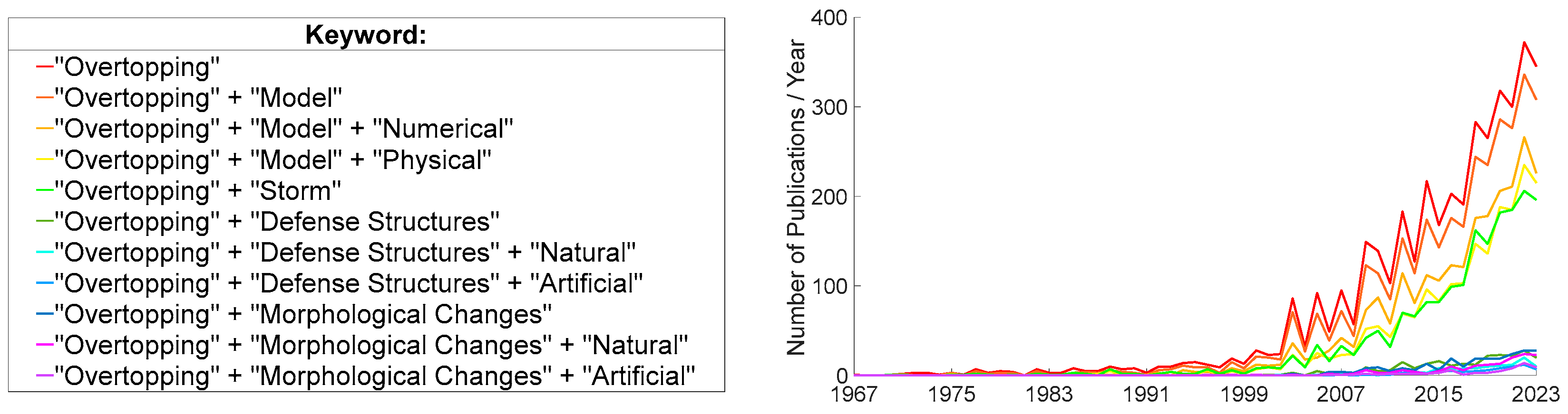
Figure 2.
Number of publications per numerical model applied in studies that includes overtopping in their simulations, on 8th October 2024 [34,35,36,37,38,39,40,41,42,43,44,45,46,47,48,49,50,51,52,53,54,55,56].
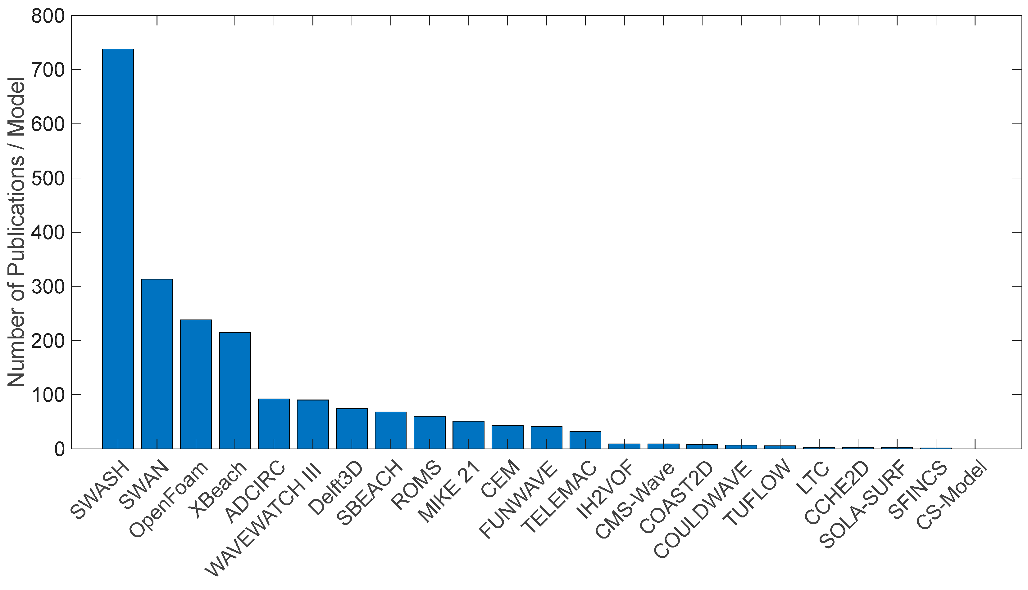

Table 1.
Number of documents available in Scopus database, considering different keywords, on the search performed on 8th October 2024.
Table 1.
Number of documents available in Scopus database, considering different keywords, on the search performed on 8th October 2024.
| Keyword | Number of Documents |
Highly Cited Author | ||
|---|---|---|---|---|
| Coastal + Overtopping | --- | --- | 4044 | Kortenhaus, A. |
| + Model | --- | 3432 | Oumeraci, H. | |
| + Numerical | 2394 | Lara, J.L. | ||
| + Physical | 1958 | Altomare, C. | ||
| + Storm | ||||
| 1919 | Kobayashi, N. | |||
| + Defense Structures | --- | 241 | Zanuttigh, B. | |
| + Natural | 118 | Bernatchez, P.; Oumeraci, H.; Sierra, J.P. | ||
| + Artificial | 74 | Zanuttigh, B. | ||
| + Morphological Changes | --- | 237 | Masselink, G. | |
| + Natural | 156 | Masselink, G. | ||
| + Artificial | 67 | Hacker, S.D.; Itzkin, M.; Masselink, G.; Ruggiero, P. | ||
Table 2.
Brief description of models that includes morphological changes in their simulations, including the number of documents available on Scopus on 8th October 2024 (N).
Table 2.
Brief description of models that includes morphological changes in their simulations, including the number of documents available on Scopus on 8th October 2024 (N).
| Numerical Model | N | Applications/References |
|---|---|---|
| SWASH (Simulating WAves till SHore) | 122 | Simulates unsteady, non-hydrostatic coastal flow and transport driven by waves, tides, buoyancy, and wind, including wave transformations, complex flow changes, and density-driven flows in coastal seas, estuaries, lakes, and rivers (https://swash.sourceforge.io/). |
| XBeach (eXtreme Beach behavior) | 64 | Solves short- and long-wave transformations, wave-induced setup, unsteady currents, overwash, inundation, and morphodynamic processes like sediment transport and dune avalanching, incorporating effects of vegetation and hard structures [37]. |
| MIKE 21 | 9 | The model analyzes water flow, currents, wave conditions, and marine processes, accurately predicting water levels, currents, temperature changes, and floods. It excels in managing complex bathymetry and external forces such as wind effects in marine and coastal environments (https://www.dhigroup.com/technologies/mikepoweredbydhi/mike-21-3). |
| COAST2D | 7 | Used to predict hydrodynamics and morphodynamics in nearshore areas. Particularly effective for analyzing coastal defense structures in both laboratory and field studies (https://coast2d.wordpress.com/). |
| FUNWAVE | 4 | The modeling includes surfzone-scale optical properties within a Boussinesq model framework and tsunami wave prediction for coastal inundation on a global/coastal scale and wave propagation on a basin scale (https://fengyanshi.github.io/build/html/index.html). |
Table 3.
Soft (S) and hard (H) coastal interventions and their advantages and disadvantages.
| Coastal Intervention | Brief Description | Advantages | Disadvantages |
|---|---|---|---|
| Artificial Nourishments (S) | Replacing sand material on beach profile that has been removed by erosion [85]. | Beaches dissipate the wave energy. Easy to monitor impact of longshore drift. | Not solving the problem and more material will be required to replace. |
| Dune Reinforcement (S) | Reinforcement of dune system to maintain the natural function. Solutions include planting vegetation, construction of fences and dikes [86]. | Dissipate the wave energy. Fixed the dune system. |
Need for maintenance if the dune is eroded by overtopping. |
| Attached Structures (H) | Rigid coastal engineering structures, typically adhering longitudinally along the coastline, used to protect against coastal erosion. Solutions include seawalls and rocky revetments [87]. | Dissipates wave energy from high impact waves. Long life span. | It prevents the movement of beach material along the coast and the beach may be lost without replenishment. Costs for construction and maintenance. |
| Detached Structures (H) | Rigid coastal engineering structures used for coastal protection, constructed parallel to the coastline, shielding the inner area from direct wave impact [88]. Detached breakwaters are a typically detached structure. | Dissipates the wave energy. |
Prevents the movement of beach material along the coast and beach may be lost without replenishment |
Disclaimer/Publisher’s Note: The statements, opinions and data contained in all publications are solely those of the individual author(s) and contributor(s) and not of MDPI and/or the editor(s). MDPI and/or the editor(s) disclaim responsibility for any injury to people or property resulting from any ideas, methods, instructions or products referred to in the content. |
© 2024 by the authors. Licensee MDPI, Basel, Switzerland. This article is an open access article distributed under the terms and conditions of the Creative Commons Attribution (CC BY) license (http://creativecommons.org/licenses/by/4.0/).
Copyright: This open access article is published under a Creative Commons CC BY 4.0 license, which permit the free download, distribution, and reuse, provided that the author and preprint are cited in any reuse.


