Submitted:
29 October 2024
Posted:
29 October 2024
You are already at the latest version
Abstract
The tight sandstone gas of the Upper Paleozoic in the Ordos Basin has become a key field for increasing reserves and production of natural gas in the basin. As a high-quality tight sandstone gas reservoir, the 8th member of the Shihezi Formation only has good gas production in the south of the basin. For this reason, the types of natural gas source rocks in the north and south of the Upper Paleozoic were summarized, and the main types of gas source rocks in the north and south were clarified. The sedimentary facies of the 8th member of the Shihezi Formation and the Shanxi Formation were analyzed. The results show that the main gas-producing source rock in the northern part of the basin is coal rock, and the main gas-producing source rock in the southern part of the basin is dark mudstone. The Permian Shanxi Formation in the northern part of the basin mainly develops the delta front, which provides good conditions for the development of coal and rock. Compared with the northern Shanxi Formation, the Permian Shanxi Formation in the southern Ordos Basin mainly develops marine facies and marine-continental transitional facies, and the coal seam is not created. Therefore, the natural gas produced by the coal of the Shanxi Formation can easily migrate to the good reservoir in the 8th member of the box, which is also the reason for the difference in the enrichment of tight sandstone gas in the north and south of the Ordos Basin.
Keywords:
Ordos Basin
; source rock
; he8 section
; shanxi formation
; gas enrichment difference
; sedimentary facies
1. Introduction
Over the past 20 years, the Upper Paleozoic strata of the Ordos Basin have provided the largest source of tight sandstone gas production in China (Sunet al., 2019 ). The output of tight sandstone gas is concentrated in the central and northern parts of the Ordos Basin (Sun et al., 2019 ; Fu et al., 2019, 2021). In recent years, the successful exploration of tight sandstone gas in the Upper Paleozoic on the edge of the Ordos Basin has provided significant support for the continuous increase of natural gas production in the basin, showing the great potential of natural gas resources in the Upper Paleozoic ( Fu et al., 2016; Zhang et al., 2018;Liu et al., 2020 ; Zhao et al., 2021; Mi et al., 2021; Ziyi W et al., 2023). The Upper Paleozoic tight gas resources in the Ordos Basin are 13.32 × 10¹² m3, accounting for 61 % of China 's tight gas resources. The sand bodies of the 8th member of the box are superimposed on each other in the longitudinal direction, and compositely connected in the transverse direction. They are distributed in a large area like a network carpet. The exploration drilling rate is more than 90 %, and the distribution of the whole basin is stable ( Zhao Huitao et al., 2021).The gas reservoir of the 8th member of the Shihezi Formation takes the Carboniferous-Permian and Benxi-Shanxi marine-terrigenous coal measures as the gas source rock, the mudstone of the 7th member of the Shihezi Formation as the direct cap rock, and the mud rock of the shore-shallow lake facies from the 4th member of the Shihezi Formation to the 1st member of the Shihezi Formation as the regional cap rock. Among the main gas-bearing intervals of tight gas in the upper Paleozoic Benxi Formation, the Taiyuan Formation, the second member of the Shanxi Formation (Shan-2 section), the first member of the Shanxi Formation (Shan-1 section) ,and the eighth member of Shihezi Formation (He-8 section), the gas reservoir of He 8 member is widely distributed in the basin and has the largest scale. However, the gas reservoirs discovered so far are mainly distributed in the northern part of the basin, and the gas reservoirs in the southern part of the basin are distributed primarily in the Shanxi Formation, Taiyuan Formation, and Benxi Formation. Previous studies on gas reservoirs in the 8th member of the Shihezi Formation mainly focused on gas-water distribution characteristics, reservoir characteristics, diagenesis, etc.They lacked research on the distribution differences of gas reservoirs in the 8th member of the Shihezi Formation.Based on previous studies, this paper summarizes and analyzes the law of differential enrichment of natural gas in the north and south of the 8th member of the Ordos Basin.
2. Regional Geological Survey
The Ordos Basin is located in the western margin of the North China Craton. It is a large multi-cycle craton basin and the most stable block (Liu, C.Y et al., 2006; Shi, W et al., 2020), covering up to 25 × 104km2 ( Li, S et al., 2019 ).In the regional tectonic unit, the western part of the basin is bounded by the Helan fault fold belt and the Liupanshan arc thrust belt, adjacent to the Alxa block. The north borders on the Guyinshan fold orogenic belt of Yimeng uplift; the east is bounded by the Yishan block; the southwestern margin is bounded by the Qilian-Qinling orogenic system (Liu, C.Y et al., 2006;shi, W et al., 2020;Ju, Y. et al., 2021). Given the current tectonic characteristics, evolution history, tectonic development,and tectonic characteristics of the Ordos Basin, it is divided into six structural units (Figure 1-1) (Li, W.Het al., 2012; Guo, Y.Het al.,1998; Xiao, H.P, 2020).
3. Distribution Characteristics of Source Rocks in He 8 Gas Reservoir
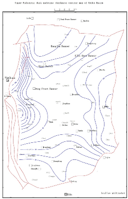
The Upper Paleozoic in the Ordos Basin is dominated by continental clastic rocks and coal measures. The source rocks of the Upper Paleozoic natural gas are mainly coal seams and dark mudstones of the Upper-Lower Shihezi Formation and the Shanxi Formation-Benxi Formation, with a little limestone in the middle. The coal in the basin is widely distributed, with a thickness of 2~30m (Figure 2-1), showing a trend of thick in the north and thin in the south, and gradually thinning from the periphery to the middle. About 70 % of the area is 3~10m thick, 15~30m thick in the Lingtao area on the western margin, 10~20m thick in the Majiatan fold belt, 5~10m thick in the northern part of the Tianhuan, 10~20m thick in the Yimeng slope, and 10~20m thick in the Yulin-Suide area. Dark mudstones are also widely distributed (Figure 2-2), which are mainly characterized by thinning from west to east. The Yinchuan graben is the thickest and thins sharply to the east, up to 800m (near Zhongning). In the vast area outside the west of the basin, it does not exceed 100m, and gradually thins from the center of the basin to the north and south. (Zheng Song et al., 2007) Previous studies have shown that the kerogen of coal and dark mudstone is mainly type III, and a small part of mudstone is type II (Figure 2-3), but the proportion is very small.From the perspective of gas source rock distribution, abundance and type as a whole, the gas source rock in Ordos Basin is widely distributed (Figure 2-5), with large thickness and high abundance (Figure 2-4), which provides a good material basis for the formation of large and medium-sized gas fields(Zhang Fuli et al., 1994).
 |
| Figure 2. Thickness contour map of Upper Paleozoic coal seam in Ordos Basin. |
 |
| Figure 2-2 Upper Paleozoic dark mudstone thickness isopach map of Ordos Basin |
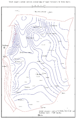 |
| Fig.2-3 Total organic carbon content contour map of Upper Paleozoic in Ordos Basin |
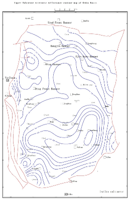 |
| Fig.2-4Isomap of vitrinite reflectance of Upper Paleozoic in Ordos Basin |
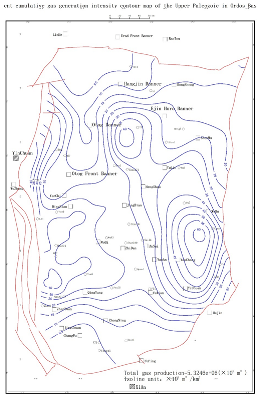 |
| Fig.2-5 The current cumulative gas generation intensity contour map of the Upper Paleozoic in Ordos Basin |
3.1. Spatial Distribution Characteristics of Hydrocarbon Source rocks in Northern Ordos Basin
Two sets of Upper Paleozoic source rocks are mainly developed in Yimeng Uplift, northern Ordos Basin, which are coal seams and dark mudstones of the Taiyuan Formation-Shanxi Formation, respectively. Previous studies suggest that the difference in sedimentary surfaces makes the thickness of source rocks in the north show the characteristics of a thick southeast and thin northwest. In the braided channel area of the alluvial fan, the thickness of the source rock is thinner, while in the swamp and floodplain area, the thickness of the source rock is thicker. The research data show that the hydrocarbon generation potential of the coal seam is significantly higher than that of mudstone, the S1 + S2 value of the coal sample is 172.52 mg / g, while that of mudstone is only 2.72 mg / g. Although the area of coal seam and mudstone is equivalent, and the thickness of coal seam is about half of that of mudstone, the organic matter abundance of coal seam is more than ten times to dozens of times that of mudstone. This huge advantage in organic matter abundance allows coal seams to make up for differences in volume, so it can be confirmed that the coal seams in the Yimeng uplift in the northern part of the basin are the main source rocks for natural gas accumulation (Xu Bo et al., 2009).
The main gas-bearing intervals in the northwestern Yishan slope of the Ordos Basin are the 8th member of the Shihezi Formation and the 1st member of the Shanxi Formation, which are tight sandstone gas reservoirs. The natural gas is derived from the Carboniferous-Permian coal-bearing source rocks (Li Jianfeng et al., 2012; Guan et al., 2022).Previous studies have shown that the natural gas of the Lower Shihezi Formation is derived from the upward migration of natural gas generated by the source rocks of the Shanxi Formation, while the source rocks of the Taiyuan Formation do not have a significant contribution. The dark mudstone in the northwest of the Yishan slope has a certain contribution to hydrocarbon generation, which belongs to medium to good source rock. As a source rock, the quality of coal rock is good, and it should belong to medium to good source rock. From the comparison of source rock types, the contribution of coal rock to hydrocarbon generation is significantly greater than that of dark mudstone (Ni et al., 2024).
According to previous statistics, the average TOC value of dark mudstone in the northern section of the Jinxi flexural fold belt is 2.4%, the average TOC value of carbonaceous mudstone is 15.2%, and the average TOC value of coal rock is 64.1 %. The coal rock is mainly distributed in the Benxi Formation (average of 9.1 m) and Taiyuan Formation (average of 7.2m) with large buried depth, and the thickness of coal rock in Shanxi Formation is thin (average of 1.9m). Carbonaceous mudstone is thicker in Benxi Formation (average of 5.6m) and Taiyuan Formation (average of 9.2m), and thinner in the Shanxi Formation (average of 3.2m). The dark mudstone is relatively thin in the Benxi Formation (average of 23.8m) and Taiyuan Formation (average of 27.1m), and the mudstone of the Shanxi Formation is the thickest (average of 43.4m). The coal of the Benxi-Taiyuan Formation is a high-quality source rock, and some dark mudstones also have good hydrocarbon generation capacity, which is a medium-good source rock (Liu et al., 2021).
The hydrocarbon source rocks in the central part of the Tianhuan Sag are mainly located in the Carboniferous Yanghugou Formation, Permian Taiyuan Formation ,and Shanxi Formation (ZOU Caineng et al., 2013; ZOU Caineng et al., 2019). Coal seams are mainly distributed in the Yanghugou Formation and the Taiyuan Formation, with a thickness of 1.0 ~ 5.0m and an average of 3.1 m. The coal seams are thick in the north and south and thin in the middle. The dark mudstone is mainly distributed in Taiyuan Formation and Shanxi Formation, with a thickness of 25.0 ~ 70.0 m and an average of 44.5m, which is characterized by thin in the north and thick in the south. The coal seam as a whole belongs to the poor-good source rock, and the dark mudstone belongs to the good-good source rock. Therefore, the hydrocarbon generation contribution rate of the dark mudstone is large in the hydrocarbon generation capacity (Zhao et al., 2023).
3.2. Spatial Distribution Characteristics of Natural Gas in Southern Ordos Basin
The Paleozoic source rocks in the southern part of the basin are mainly developed in the Carboniferous-Permian, and the lithology is primarily dark mudstone, carbonaceous mudstone,and coal (Gu Chao et al., 2020).
In the southwestern part of the Ordos Basin, a large area of coastal swamp facies coal-bearing source rocks (Jingxianghui et al., 2023) were developed in the Permian. Due to the lack of an Upper Paleozoic Carboniferous system, two sets of source rocks are mainly produced in the southwestern part of the basin, namely Taiyuan Formation and Shanxi Formation coal-bearing strata. The main source rocks are the coal seams of Shanxi Formation and Taiyuan Formation, and the dark mudstones developed during them are secondary source rocks. The coal seams are mainly distributed at the top of the Taiyuan Formation (generally 1 ~ 2 sets are developed), with a cumulative thickness of 1~4m and an average thickness of 2.5m. The dark mudstone is developed in the Shan 2 member, with a thickness of 60~90m and an average thickness of 72 m. It is stable in the southwest of the basin. (Meng et al., 2021) The thickness of Permian coal rock is 2-13m, and the TOC content is between 73.5% and 91.33%. The thickness of dark mudstone and carbonaceous mudstone is 3-95.0m, and the TOC content is between 0.26% and 8.93%.The kerogen type is mainly the humic-humic type. The vitrinite reflectance (Ro) of source rocks is 1.6%~3.0%, generally more than 2.0%, which is in the stage of high mature-over-mature dry gas. The average hydrocarbon generation intensity is 15.5×10⁸ m3 / km2(Li Jun et al., 2016), which has good hydrocarbon generation ability(Yang et al., 2005).The high thermal evolution degree of coal measure source rocks in the southwest makes up for the disadvantage of thickness thinning, so it can provide a sufficient gas source for natural gas accumulation.
The upper Paleozoic in the southeast of Yishan slope in Ordos Basin is composed of Carboniferous Benxi Formation, Permian Taiyuan Formation, Shanxi Formation, Lower Shihezi Formation, Upper Shihezi Formation,and Shiqianfeng Formation from bottom to top (Fig.2). The dark mudstone of coal measures is mainly developed in Shanxi Formation and Benxi Formation. The cumulative thickness of strata is 130~ 195m in the vertical direction, and the thickness of dark mudstone of coal measures is generally 70~120m. The thickness of the strata drilled in the Shanxi Formation is 100~135m, and the thickness of the dark mudstone in the coal measures 55~85m, accounting for about 55% of the total thickness of the strata. The thickness of the dark mudstone in the coal measures of the Shanxi Formation is generally 65~75m, and it becomes thinner in the southwest, and the thickness is less than 65m. The thickness of the strata drilled in the Benxi Formation is 30~60m, and the thickness of the dark mudstone in the coal measures is generally 15 ~ 35m, accounting for about 60% of the total thickness of the strata. The thickness of dark mudstone in Benxi Formation coal measures gradually thins to the west and south, less than 15m in the west and less than 20m in the south. Coal rock is mainly developed in the Shanxi group and Benxi group.
The coal rock of the Shanxi Formation is relatively developed, which is mainly developed in the Shan 2 section in the longitudinal direction. The thickness of coal rock is generally 1~4m, and the maximum thickness can reach 5m. The Benxi Formation is generally characterized by fewer coal-rock interlayers and larger single-layer thickness than the Shanxi Formation. It is concentrated in the first section (No.8 coal) in the longitudinal direction. The thickness is generally 1-5m, and the maximum thickness can reach 6m. The dark mudstones of Benxi Formation and Shan 2 Member are generally medium-good source rocks, and the dark mudstones of Shan 1 Member are generally poor source rocks-non-hydrocarbon source rocks (Cao et al., 2015).
4. Sedimentary Facies in the North and South of Ordos Basin
4.1. Sedimentary Facies Division Marks
The sedimentary markers of the sedimentary system include rock color, composition, rock type combination, structure, sedimentary structure, particle size distribution, profile structure, etc. These characteristics are important indicators reflecting the sedimentary environment.
4.1.1. Lithology Marks
1) Color
In the north: the color of mudstone in the lower and upper sections of He 8 is gray black and dark gray, and there are occasional variegated mudstone. The color of sandstone is mainly light gray, gray-white,and gray-green (Figure 3-1). Gray black and dark black are more common in the lower part of box 8 and the middle and upper part of box 8(Zhou, 2012; Yu Tangbo, 2010).
For the lower and upper parts of He8 in the northern part of the basin, the colors of mudstone are mostly variegated, grayish green, brown, gray,and brown, followed by grayish black and dark gray. Brown and variegated are more common in the lower part of He8 and the middle and upper part of He8, and variegated or brown mudstones are often interbedded with gray and gray-green mudstones, reflecting that the water level of the sedimentary environment changes frequently. The water body often changes between the oxidizing environment and the reducing environment, and the sediments may be exposed. Combined with its regional sedimentary background, it is speculated that the early sedimentary environment of the lower part of He8 and the upper part of He8 may be a seasonal arid climate environment, and the flow rate of the sedimentary water body changes greatly. The sandstones are mostly gray-white, gray-green,and gray. The mudstones of the Shan 1 member of the Shanxi Formation are dark gray and gray-black, and the sandstones are mostly gray-white and light gray, reflecting that the sedimentary climate was humid and the sedimentary environment was weak reduction-reduction environment(Tan Wancang, 2009).
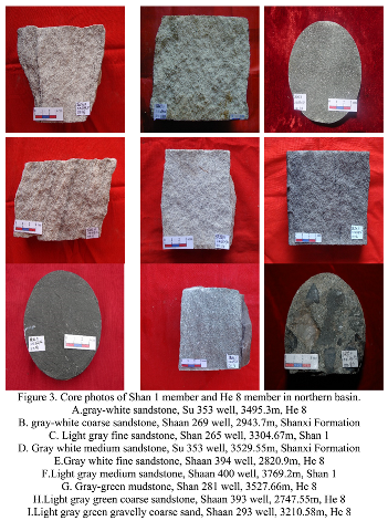 |
Southern: Through the detailed observation and description of the cores of 31 wells in the southern part of the basin, the sandstone in the southern part of the basin is mainly light gray and grayish green. The mudstones in the Shan 1 member are mostly variegated, grayish green and gray, followed by grayish black and black, showing plant debris, charcoal, thin coal seams, and bioturbation. The light gray, grayish green,and purplish red mudstones are common in the He8 section, reflecting that the sedimentary water body of this section is relatively shallow. A small amount of carbon mudstone and terrestrial plant fragments can be seen in the coring section, reflecting that the water level of the sedimentary environment has changed, and the sedimentary environment is a weak oxidation-reduction environment (Fig.3-2).
 |
2 ) Sedimentary structure marks
In the north: the rock sedimentary structure types of Shan1 to He8 are mainly horizontal bedding, parallel bedding, cross-bedding, graded bedding,and erosion surface (Figure 3-3).
Horizontal bedding is mainly developed in the flood-plain of a braided river and the natural levee, crevasse splay,and floodplain of a meandering river.
Parallel bedding is often formed under the hydrodynamic conditions of shallow water and rapid flow and is mainly found in the sedimentary environment of the heart beach or side beach with strong hydrodynamic force.
The tabular cross-bedding is mainly found in the sedimentary environment of the heart beach or the side beach with strong hydrodynamic force.
The wedge-shaped cross-bed is composed of gray-light gray coarse, medium,and fine sandstone. It is characterized by wedge-shaped contact of each layer on the cross-section, mostly formed in the sedimentary environment of the heart beach and the side beach.
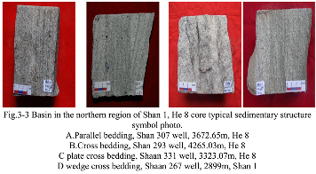 |
Southern: The observation and description of the core in the southern part of the basin indicate that parallel bedding and tabular cross-bedding are common in the Shan 1 member; the sedimentary structure of the He8 member is mainly large trough cross-bedding and wedge bedding (Fig.3-4).
1 ) Parallel bedding is common in channel sedimentary environments such as delta plain surfaces distributary channels.
2 ) Plate cross bedding often appears in the delta plain surfaces distributary channel and delta front surfaces underwater distributary channel, estuary sand dam environment.
 |
3 ) Trough cross-bedding is mostly formed in meandering river beach sand dam or delta front underwater distributary channels and estuary sand dams deposition.
4 ) Wedge cross bedding: The interface of the cross-bedding is a non-parallel plane, and the layer system converges to another section due to the change of thickness and intersects in a wedge shape.
3 ) Log facies marker
There are several types of logging facies in the basin:
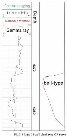
A. Bell-shaped curve
The characteristics of the bell curve are the curve of the relationship between the bottom mutation and the top gradient, which reflects the sedimentary characteristics of the coarse-to-fine underwater distributary channel sand body composed of medium-fine sandstone, siltstone, argillaceous siltstone, silty mudstone to mudstone (Fig.3-5).
 |
b. Box-shaped curve
The box-shaped curve is characterized by a sudden change in the bottom and top or a slight positive rhythm change to a box shape, reflecting the sedimentary characteristics of the underwater distributary channel composed of fine sandstone and silty fine sandstone with multi-rhythm superposition. The internal structure is not uniform, and there may be multiple mudstone interlayers. Therefore, based on the box-shaped curve, the intermediate curve will show the corresponding toothing, reflecting the intermittent hydrodynamic energy change of the water body (Fig.3-6).
4.2. Types and Characteristics Of Sedimentary Facies
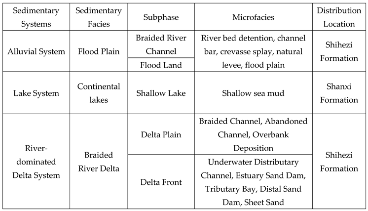
North: According to the characteristics of regional sedimentary patterns, sequence stratigraphic characteristics,and sedimentation, on the basis of many previous research results, the main sedimentary facies types are identified by core facies and logging sedimentary facies markers. The northern part of the basin is divided into three sedimentary systems (Pang et al., 2021), and the division of each facies belt is shown in Table 3-1.
4.2.1. Impact Plain
Braided river channel surfaces and floodplain surfaces are developed in the alluvial plain.

Table 3.
Upper Paleozoic sedimentary system division table in northern Ordos Basin.
 |
(1) Riverbed retention deposits: The lithology is mainly coarse sandstone, gravel-bearing coarse sandstone,and conglomerate at the bottom. When the hydrodynamic conditions are strong, the coarser gravel is deposited at the bottom of the riverbed.
(2) Bottomland: The sediment thickness is similar to the riverbed depth, and its width depends on the size of the river.
(3) Floodplain: Floodwater flooding can form a wide and flat floodplain sedimentary area. The sediments are not only muddy but also have a large number of sandy deposits. It is mainly developed on the outside of the river channel. The lithology is the variegated and gray-black mudstone formed by suspended matter, and the horizontal bedding and sand texture are developed.
(4) Deposition of natural levees: Because the river water overflows the river bank during the high flood period, the fine-grained sediments carried by the river water level drop are long-banded and ridge-shaped deposits formed outside the river channel. The common sedimentary structures are horizontal bedding and sand bedding, with obvious frequent sand mud interbedding.
(5) Crevasse splay deposition: in the high water level of the flood season, the flood overtook the embankment accumulation formed
4.2.2. Braided River Delta
The braided river delta facies develop delta plain surfaces and delta front surfaces.
A. Delta front facies
(1) Underwater distributary channel: It is composed of gravelly coarse sandstone, medium sandstone,and fine sandstone, with medium sorting and low compositional maturity and structural maturity. Sedimentary structures such as bottom erosion, trough cross-bedding, parallel bedding,and horizontal bedding are developed. The natural potential curve and natural gamma curve show bell-shaped, tooth-shaped bell-shaped,and micro-tooth-shaped box-shaped.
(2) Estuary sand dam: the lithology is composed of medium-coarse-grained sandstone, medium-grained sandstone,and coarse-grained sandstone. The sandstone is well-sorted and rounded. The sedimentary structures are mainly tabular cross-bedding, parallel bedding, graded bedding, ripple bedding, etc., and flushing bedding is also seen. The profile structure is characterized by upward coarsened reverse grain order.
(3) Interdistributary bay: It is mainly composed of mudstone and silty mudstone, with a small amount of siltstone or fine sandstone, and wormholes are developed. Horizontal bedding development, see lenticular bedding and wave marks; it is a low-lying deposit between underwater distributary channels.
( 4 ) Far sand dam: Due to the weak transformation of lake waves, the deposition of the far sand dam in the northern part of the basin is relatively undeveloped.
b. Delta plain facies
( 1 ) Braided channel: the lithology is coarse, often composed of conglomerate, pebbly sandstone,and sandstone, of which the main lithology is pebbly sand medium and coarse sandstone; the maximum thickness of a single sand body varies from 0.2 m to 2.5m.
( 2 ) Abandoned channel: The filling deposits are often formed by the sudden change of the water system and the diversion of the channel, which are lens-shaped, and the sand bodies gradually become thinner on both sides. The lithology is not much different from the braided channel, and the overall grain size is finer than the river channel.
( 3 ) Cross-bank deposition: It is the fine-grained material deposited in the water-filled depressions on both sides of the river during the flood period, which is mainly composed of thin interbeds of siltstone and mudstone, and develops ripple bedding.
c.Lakes
The lake sedimentary system is developed in the Shanxi Formation and the lower Shihezi Formation. It is mainly shallow lake facies, distributed on both sides of the delta front, mainly shallow lake surfaces. Shallow lake sediments are located in the area from the inner side of the lakeside subfacies to the wave base surface. The water body is deeper than the lakeside area, and the sediments are strongly affected by waves and lake currents. The lacustrine facies deposits are characterized by dentate linear type on the logging curve.
South: Based on the characteristics of regional sedimentary pattern, sequence stratigraphic characteristics,and sedimentation,based on many previous research results, through core facies and logging facies markers, combined with provenance and tectonic background, the upper Paleozoic in the south of the basin is divided into 3 types of facies, 5 types of subfacies and 13 types of microfacies ( Table 3-2 ).
Table 3.
Upper Paleozoic sedimentary system division table in southern Ordos Basin.
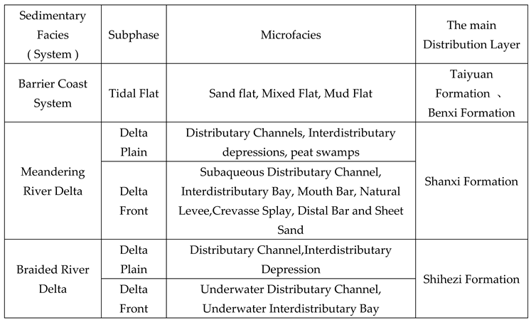 |
4.2.3. Delta Sedimentary System
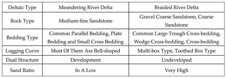
There are two types of deltas in the southern part of the basin, namely the meandering river delta and the braided river delta ( Table 3-3 ).
A. Delta plain surfaces
The delta plain is the aquatic sedimentary part of the delta. It begins at a large number of bifurcations of the river and ends at the shoreline or lake level.
Table 3.
Comparison of sedimentary characteristics of Shan 1 meandering river delta and He 8 braided river delta in the southern part of the basin.
Table 3.
Comparison of sedimentary characteristics of Shan 1 meandering river delta and He 8 braided river delta in the southern part of the basin.
 |
( 1 ) Branch Channel (braided channel)
The branch channel is a part of the framework in the delta plain. It is often in contact with the underlying rock layer by bottom erosion. It has a positive sedimentary sequence with upward thinning. The bottom sandstone contains scattered mud gravel, plant stems,and other residual sediments.
( 2 ) Inter-river Depressions (marshes)
The inter-channel depression is a low-energy depression area between the main distributary channels. The lithology is mainly dark gray mudstone and silty mudstone, with a small amount of lenticular siltstone and fine sandstone. The horizontal texture is developed in the rock, the biological disturbance is strong, and the natural gamma curve is mostly high amplitude finger shape.
b.Delta Front surfaces
The delta front surface is part of the underwater sedimentary body near the estuary of the delta plain distributary channel into the lake basin, and it is also the main component of the delta sedimentary system.
( 1 ) Underwater distributary channel
Underwater distributary channels are generally distributed in a network. The lithology of the underwater distributary channel in the south of the basin is mainly gray medium (fine)-grained sandstone. The thickness of the single sand body is generally 1.0 ~ 3.6m, and the mudstone interlayer is mainly dark gray and gray-black. The bottom of the sandstone has a scouring surface, which is often in contact with the underlying rock strata.
( 2 ) Interdistributary Channel (tributary bay)
The interdistributary bay is a low-energy sedimentary environment, which is usually dominated by the vertical accretion of fine-grained suspended matter in the overflow channel during the flooding period. Therefore, the interdistributary bay is dominated by clay deposition and contains a small amount of silt.
( 3 ) Underwater Natural Levee
The lithology of the underwater natural levee in the south of the basin is mainly dark gray siltstone and black-gray argillaceous siltstone.
3.3 Single well sedimentary facies analysis
Based on the study of various facies markers, combined with core observation, the vertical evolution of sedimentary facies and the distribution law of the plane are studied. Based on careful observation of the cores in the north and south of the basin, the comprehensive histogram of the single well is drawn.
Figure 3.
Comprehensive histogram of sedimentary facies of Shanxi Formation-He8 in Su422 well in the northern part of the basin.
Figure 3.
Comprehensive histogram of sedimentary facies of Shanxi Formation-He8 in Su422 well in the northern part of the basin.
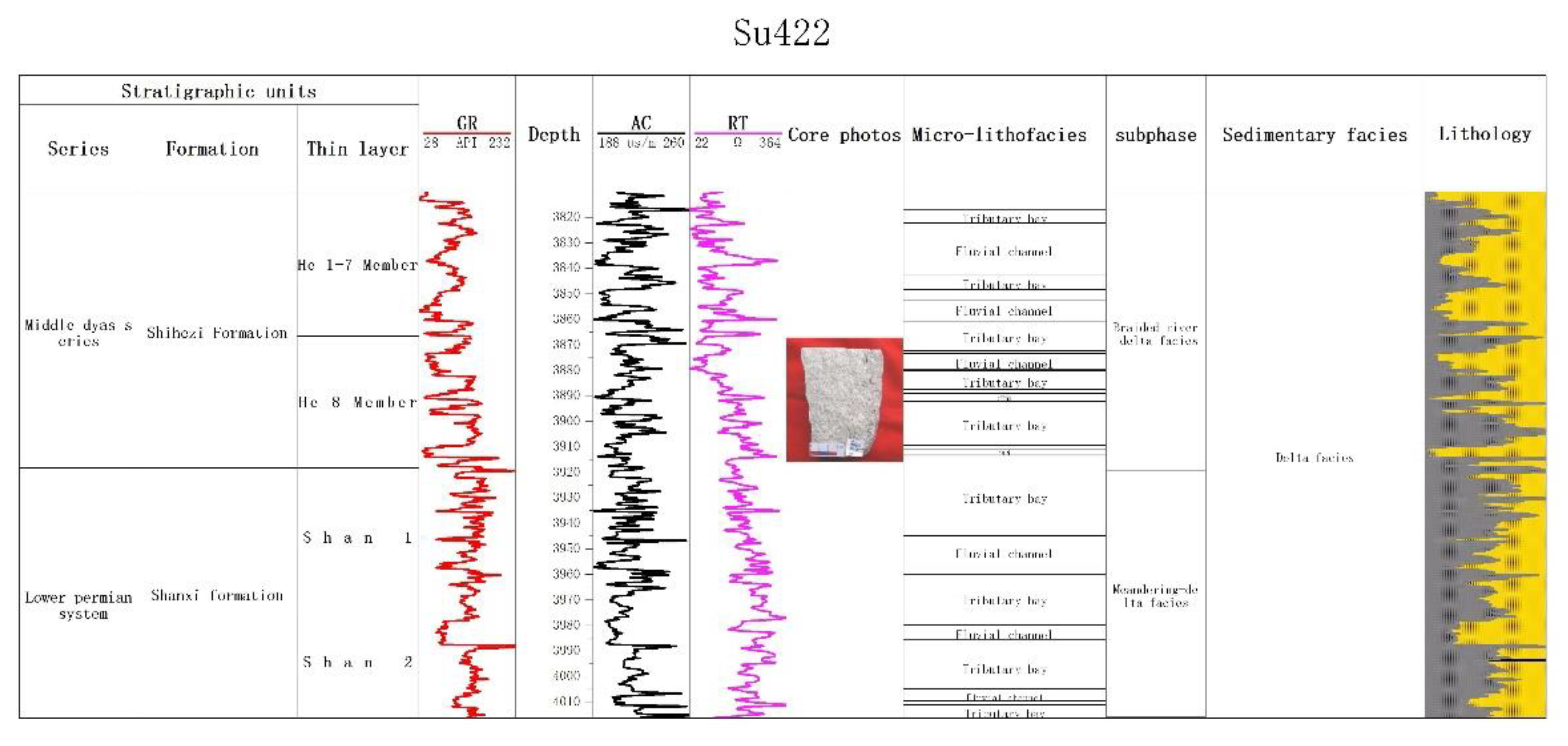
Su 422 Well is located in the northern part of the basin, with a depth range of 3866.2-4015 m. The total thickness of Shan 1 and He 8 formations is about 106.4 m, which is generally gray-white medium-coarse-grained quartz sandstone. The Shanxi Formation is a meandering river delta front deposit, and the He 8 member is a braided river delta front deposit. The microfacies include branch channels and interdistributary bays (Figure 3-7).
The Shanxi Formation: This section is a meandering river delta front deposit, and the lithology is mainly light gray pebbly coarse sandstone with dark gray mudstone. The sedimentary structures include erosion surface, tabular cross-bedding,and horizontal bedding. The natural gamma curves of gravel-bearing coarse sandstone, coarse sandstone,and medium sandstone are medium-high toothed box-shaped. The natural gamma curves of mudstone and silty mudstone are low-amplitude micro dentate mudstone baselines. Among them, pebbly coarse sandstone, coarse sandstone, and medium sandstone are riverbed retention deposits, beach deposits or abandoned channel deposits, mudstone,and silty mudstone are flood lake deposits.
He 8 section: He 8 section is braided river delta front deposition, developed a set of dark gray mudstone. The sedimentary microfacies are braided channels, abandoned channels,and overbank deposits. The braided channel microfacies are gravelly coarse sandstone and medium-fine sandstone, and its natural gamma logging curve is a high-amplitude toothed box type. The abandoned channel microfacies are gray fine sandstone, and its natural gamma logging curve is medium-amplitude toothed box type.
4.4. Analysis of Sedimentary Connected Well Profile
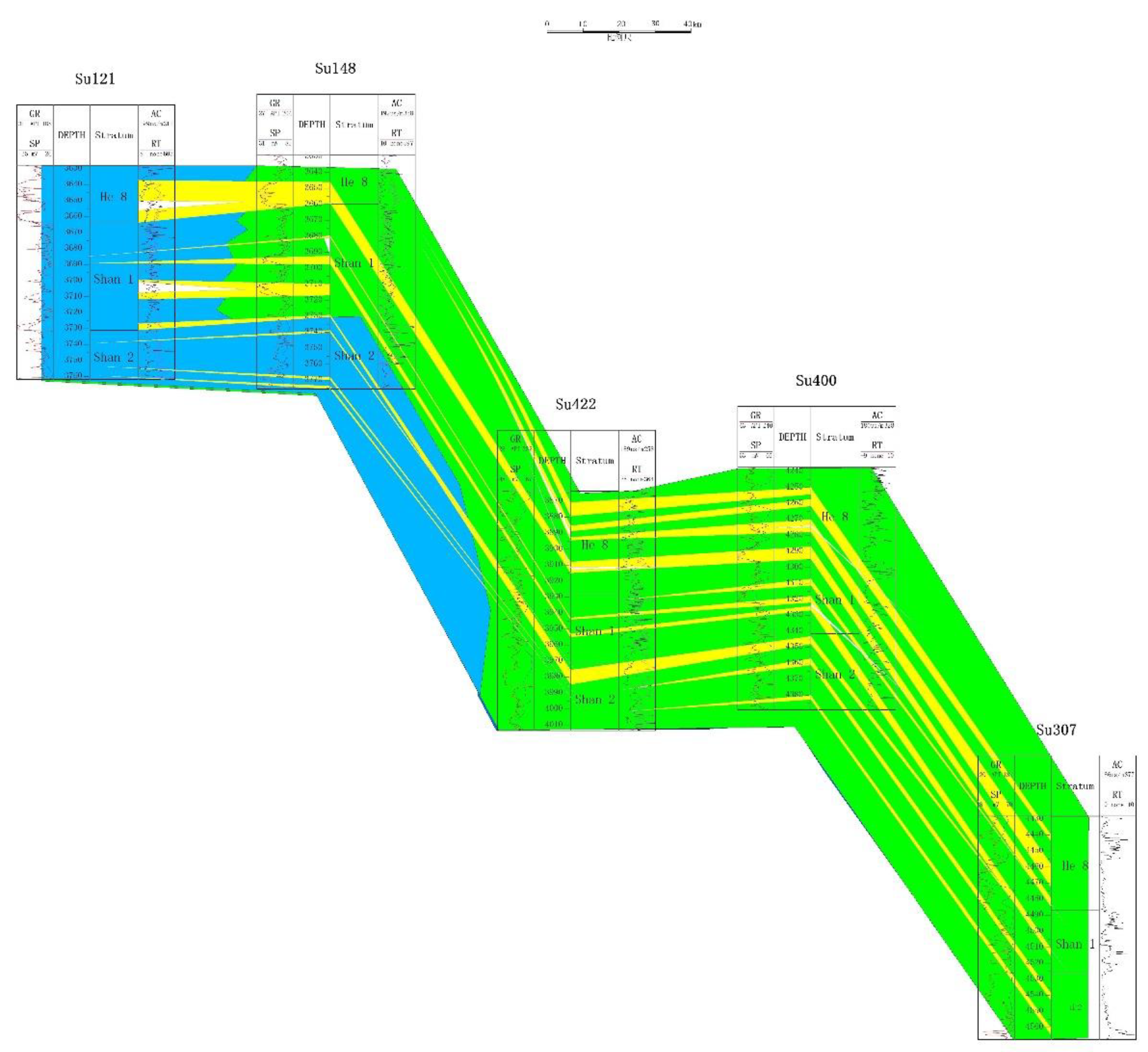
The profile is a north-south sedimentary connected well profile, which passes through five wells of Su 307-Su 400-Su 422-Su 148-Su 121 in turn.
From the observation of this section, it can be seen that the sub-facies combination model of braided river delta plain-braided river delta front was formed in the 8th member of the Shihezi Formation. During the sedimentary period of the 1st member of the Shanxi Formation, the braided river delta plain sub-facies-braided river delta front was successively developed (Fig.3-8). During the sedimentary period of the 2nd member of the Shanxi Formation, the littoral and shallow sea sedimentary facies were also developed. The Su 121-Su 148 area develops the braided river delta plain surfaces and then transitions to the braided river delta front surfaces. The boundary of the two subfacies mainly appears near the location of the Su 422 well and Su 148 well. In this section, the braided river delta plain surfaces mainly develop large-scale sandy sediments, and the distributary channel microfacies are developed. There are five-channel sand bodies with small thicknesses and narrow ranges and two-channel sand bodies with large thicknesses and wide ranges. The braided river delta front surfaces are widely distributed in this section, and the channel sand body is greatly improved in thickness, connectivity,and distribution range than the braided channel on the delta plain. However, the channel sand is still surrounded by widely distributed inter-river mud. The water body gradually deepens from south to north, and the thickness of the channel sand body gradually increases from south to north. This shows that although the water body as a whole deepened during this period, there was a sudden change in water level in some areas, and the source supply was sufficient. Typical inter-tributary bay microfacies are developed in the Su 400 well-Su 307 well interval, during which a large number of brown or black carbonaceous mudstones are deposited, while the underwater distributary channel microfacies in the front are mainly concentrated in the well control area where the Su 422 well-Su 400 well is located. Among them, the underwater distributary channel of the delta front is mainly coarse-medium sandstone, and the grain size is smaller than that of the delta plain branch channel sand body, but the grain size sorting is better.
Figure 3.
Su 121 well-Su 307 well Shanxi Formation-He 8 section sedimentary connected well profile.
4.5. The Plane Distribution Characteristics Of Sedimentary Facies
The shallow water delta sedimentary system is mainly developed in the southern Ordos Basin, and the provenance is affected by the ancient water system from the southwest, south,and north.
4.5.1. Sedimentary facies distribution of Shanxi Formation
The combination form of the meandering river delta plain-meandering river delta front-shore shallow lake surface was formed in the Shan 1 period. The sand body development scale is relatively small, the thickness is thin, the lithology is mainly medium-fine-grained sandstone with less gravel, the bottom erosion phenomenon is not significant, the distributary channel sand body is distributed in the north-south direction, and the characteristics of local contiguous. The delta front surfaces in the northern part of the delta front belt are advancing to the southwest and still form a lobed delta. The range of shallow lake or lakeside mud is large, mainly distributed in the front of the delta front, showing a curved and continuous distribution (Fig.3-9).
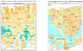 |
| Figure 3. a.Sedimentary facies map of Shan 1 of Permian Shanxi Formation in Ordos Basin. |
| Figure 3. b.Sedimentary facies map of Shan 2 of Permian Shanxi Formation in Ordos Basin. |
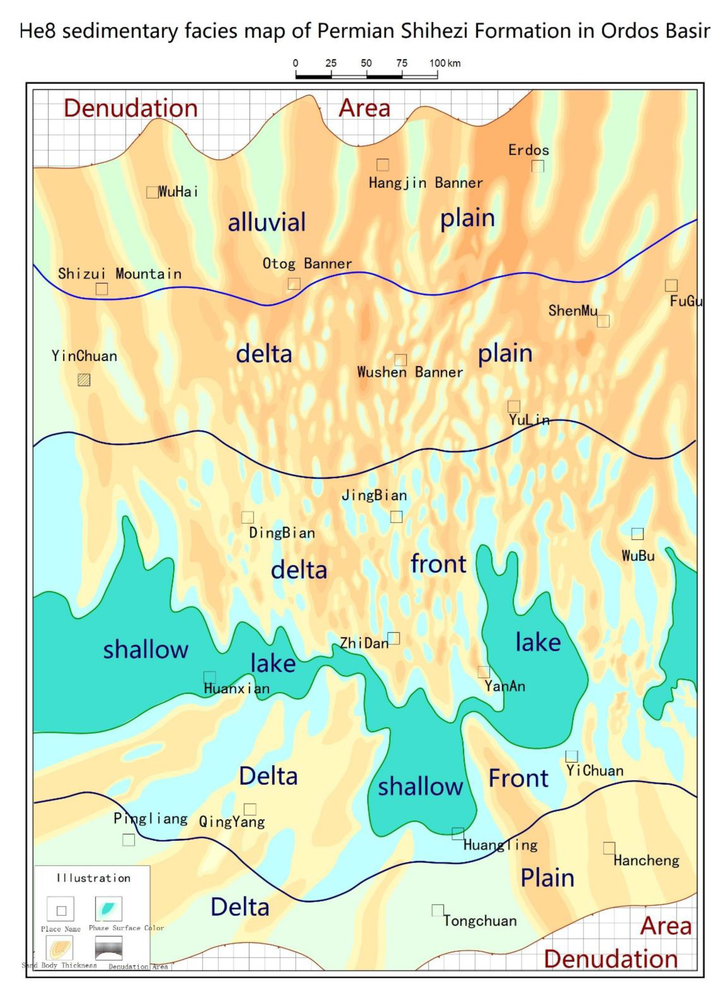
4.5.2. Sedimentary Facies Distribution of Shihezi Formation
The braided river delta facies are mainly developed (Fig.3-10), while the lacustrine facies are only a small-scale development in the middle of the study area. The braided distributary channel sand bodies are vertically superimposed on each other, and the degree of lateral interweaving is slightly increased. The braided river delta plain surfaces are mainly distributed in the area south of Shatan 1-Chengtan 1.
Figure 3.
Plane distribution of sedimentary facies of He 8 member in the basin.
5. Analysis
The source rocks are widely distributed in the Upper Paleozoic of Ordos Basin. From a macro point of view, reservoir rocks are controlled by sedimentary facies. Through the analysis of the source rocks in the northern and southern parts of the basin, it can be seen that the natural gas source rocks in the northern part of the basin are mainly coal seams of Shanxi Formation, and the natural gas source rocks in the southern part of the basin are mainly dark mudstones of Taiyuan Formation and Benxi Formation.
The Permian Shanxi Formation in the northern Ordos Basin mainly develops the delta front, which provides good conditions for the development of coal rock. The natural gas produced by the coal of the Shanxi Formation can easily migrate to the good reservoir in the 8th member of the box. Therefore, the He8 member in the northern part of the basin has good gas-bearing properties. Compared with the Shanxi Formation in the north, the Permian Shanxi Formation in the southern Ordos Basin mainly develops marine facies and marine-continental transitional facies, and the coal seams are not developed. The natural gas produced by the dark mudstone of the Taiyuan Formation and Benxi Formation is separated from the good reservoir of the southern He 8 section. The Shanxi Formation makes the displacement of natural gas migration longer and the resistance is greater. Therefore, the natural gas in the southern part of the basin is difficult to migrate to the He 8 reservoir in the southern part of the basin, resulting in the natural enrichment in the northern part of the He 8 section of the Ordos Basin. The distribution pattern in the south is less.
References
- F. Zhang, L.I. Jun, W.E.I. Guoqi, L.I.U. Xinshe, G.U.O. Jianying, L.I. Jian, et al.Formation mechanism of tight sandstone gas in areas of low hydrocarbon generation intensity: a case study of the Upper Paleozoic in North Tianhuan Depression in Ordos Basin, NW China Petrol. Explor. Dev., 45 (1) (2018), pp. 79-87. [CrossRef]
- Guo, Y.H.; Liu, H.J.; Quan, B.; Wang, Z.C.; Qian, K. Late paleozoic sedimentary system and paleogeographic evolution of ordos area. Acta Sedimentol. Sin. 1998, 16, 44–51, (In Chinese with English abstract). [Google Scholar]
- H. Zhao, X. Liu, Li Jia.Accumulation regularity and target of tight sandstone gas in low hydrocarbon generation intensity area of northern Tianhuan Depression,Ordos Basin.2021,Nat. Gas Geosci., 32 (2021), pp. 1190-1200. [CrossRef]
- Ju, Y.; Yu, K.; Wang, G.; Li, W.; Zhang, K.; Li, S.; Guo, L.; Sun, Y.; Feng, H.; Qiao, P.; et al. Coupling response of the Meso–Cenozoic differential evolution of the North China Craton to lithospheric structural transformation. Earth-Sci. Rev. 2021, 223, 103859. [Google Scholar] [CrossRef]
- L. Mi, G. Zhu,Geological characteristics and exploration breakthrough in linxing-shenfu tight gas field, northeastern Ordos Basin,China Petroleum Exploration, 26 (2021), p. 53. [CrossRef]
- L. Sun, C. Zou, A. Jia, et al.Development characteristics and orientation of tight oil and gas in China Petrol. Explor. Dev., 46 (2019), pp. 1073-1087. [CrossRef]
- Liu, C.Y.; Zhao, H.G.; Gui, X.J.; Yue, L.P.; Zhao, J.F.; Wang, J.Q. Space-Time coordinate of the evolution and reformation and mineralization response in ordos basin. Acta Geol. Sin. 2006, 05, 617–638. [Google Scholar]
- Li, S.; Li, X.; Wang, G.; Liu, Y.; Wang, Z.; Wang, T.; Cao, X.; Guo, X.; Somerville, I.; Li, Y.; et al. Global Meso-Neoproterozoic plate reconstruction and formation mechanism for Precambrian basins: Constraints from three cratons in China. Earth-Sci. Rev. 2019, 198, 102946. [Google Scholar] [CrossRef]
- Li, W.H.; Chen, Q.; Li, Z.C.; Wang, R.G.; Wang, Y.; Ma, Y. Lithofacies palaeogeography of the Early Paleozoic in Ordos area. J. Palaeogeogr. 2012, 14, 85–100. [Google Scholar]
- N. Fu, S. Yang, H. Qing High-efficiency reservoir formation conditions of tight sandstone gas in Linxing-Shenfu blocks on the east margin of Ordos Basin Acta Pet. Sin., 37 (2016), p. 111. [CrossRef]
- Shi, W.; Dong, S.; Hu, J. Neotectonics around the Ordos Block, North China: A review and new insights. Earth-Sci. Rev. 2020, 200, 102969. [Google Scholar] [CrossRef]
- Xiao, H.P. Depositional System and Favorable Reservoir of Shanxi Formation-He 8 Member in Ordos Basin; China University of Geosciences: Beijing, China, 2020; (In Chinese with English abstract). [Google Scholar]
- Y. Liu, W. Shi, K. Liu, R. Wang, R. Wu.Natural gas accumulation patterns of upper paleozoic in eastern hangjinqi area, Ordos Basin Lit. Res., 32 (2020), pp. 56-67.
- ZOU Caineng,YANG Zhi,TAO Shizhen,et al.Continuous hydrocarbon accumulation over a large area as a distinguishing characteristic of unconventional petroleum:the Ordos Basin,north-central China[J].Earth-Science Reviews,2013,126:358-369. [CrossRef]
- ZOU Caineng,YANG Zhi,HUANG Shipeng,et al.Resource types, formation,distribution and prospects of coal-measure gas[J].Petroleum Exploration and Development,2019,46(3):45 1-462. [CrossRef]
- Ziyi W,Nengwu Z,Shuangfang L, et al.Generation, accumulation, and distribution of Upper Paleozoic tight sandstone gas in the northeastern margin of the Ordos Basin[J].Marine and Petroleum Geology,2023,156. [CrossRef]
- Cao Yue, Yin Xiao, Zhao Qianping, et al. Characteristics and exploration direction of Upper Paleozoic source rock in Yanchang block of southern Ordos Basin [J].China Petroleum Exploration, 2015,20 (03) : 13-21.
- Gu Chao, Cao Jiankang, Zhuang Yipeng, et al. Geochemical characteristics of Upper Paleozoic source rocks in Xunyi block, Ordos Basin [J]. Northwest Geology, 2020,53 ( 02 ) : 263-269. [CrossRef]
- Guan Wei, Liu Chiyang, Li Han, et al. Production behaviors of condensate oil from gas reservoirs in southeastern Sulige gas field, Ordos Basin [J].Xinjiang Petroleum Geology, 2022,43 (01) : 52-58. [CrossRef]
- Jing Xianghui, Zhang Lei, Li Han, et al. Geological characteristics and exploration potential of gas accumulation in aluminiferous rock series in southwestern Ordos Basin [C] / / China Petroleum Institute Natural Gas Professional Committee. The 33 rd National Natural Gas Academic Year (2023) Proceedings (01 Geological Exploration). Research Institute of Exploration and Development, PetroChina Changqing Oilfield Company ; national Engineering Laboratory for Exploration and Development of Low Permeability Oil and Gas Fields ; 2023 : 13.
- Liu Chang, Zhang Daomin, Li Chao, et al. Upper Paleozoic tight gas sandstone reservoirs and main controls, Linxing block, Ordos Basin[J]. Oil & Gas Geology, 2021,42 (05) : 1146-1158.
- Liu Xiaopeng, Han Xinggang, Zhao Huitao, etc. Distribution characteristics and genetic analysis of gas and water in tight gas reservoirs of the 8th section of Shihezi Formation in Ordos Basin, China [J].Natural Gas Geoscience, 2023, 34 (11) : 1941-1949. [CrossRef]
- Li Jun, Wang Yunuo, Zhao Jingzhou, etc. Accumulation patterns of natural gas in the Upper Paleozoic in Longdong area,Ordos Basin [J].Oil & Gas Geology, 2016,37 (02) : 180-188.
- Li Jianfeng, Ma Jun, Zan Chuanli, et al. Genesis of Upper Paleozoic Condensate in Ordos Basin [J].Natural Gas Geosciences, 2012,23 (2) : 313-318.
- Meng Xiaoling, Ai Qinglin, Wang Jincheng, et al. Reservoir-forming conditions of deep tight sandstone gas reservoirs, Qingyang gasfield, Ordos Basin [J].Natural gas exploration and development, 2021,44 (01) : 104-110.
- Ni Chunhua, Wu Xiaoqi, Wang Ping, etc. Geochemical characteristics of light hydrocarbons in Upper Paleozoic tight gas from Daniudi Gas Field, Ordos Basin [ J ].Petroleum Geology & Experiment, 2024, 46 (02) : 366-379. [CrossRef]
- Pang Jungang, Li Wenhou, Guo Ji 'an, Ruan Yu, Li Weihong, Chang Liangjie, Gong Binli, Wang Xinyue, Guo Yanqin, Ma Zhiguo. Depositional system and paleogeographic evolution of the cretaceous of Ordos Basin [J]. Journal of Northwest University(Natural Science Edition), 2021, 51 ( 2 ) : 314-324.
- Tang Bo. Characteristics of Sedimentary Facies in the 8th Member of Shihezi Formation of South Sulige Gas Field [J].Liaoning Chemical Industry, 2010,39 (03) : 324-328.
- Tan Wancang. Study on sedimentary facies of He 8 and Shan 1 in the northern Sulige gas field, Ordos Basin [D]. Chengdu University of Technology, 2009.
- Xu Bo, Nie Haikuan, Wang Min, et al. A study of hydrocarbon-generating potential of Hangjinqi prospect area in Ordos Basin [J].Oil and gas geology and recovery, 2009,16 ( 4 ) : 38-40.
- Yang Hua, Fu Jinhua, Wei Xinshan. Characteristics of natural gas accumulation in Ordos Basin [J].Natural gas industry, 2005, ( 04 ) : 5-8 + 189-2.
- Zhao Huitao, Liu Xiaopeng, Jia Li, et al. Accumulation regularity and target of tight sandstone gas in low hydrocarbon generation intensity area of northern Tianhuan Depression,Ordos Basin [J].Natural Gas Geoscience, 2021, 32(8) : 1190-1200.
- Zheng Song, Tao Wei, Yuan Yusong, et al.Evaluation of gas resource kitchen for the upper paleozoic coal measure,Ordos Basin[J]. Gas Geoscience, 2007, (03) : 440-446.
- Zhang Fuli, Huang Shunxing, Yang Changgui, etc. Natural Gas Geology of Ordos Basin [M].Beijing : Geology Press, 1994.
- Zhao Weibo, Huang Daojun, Wang Kangle, et al. Accumulation conditions and key technologies of exploration and development for Qingshimao gas field in Ordos Basin [J].Acta Petrolei Sinica, 2023,44 (10) : 1739-1754. [CrossRef]
- Zhou Biao. Study on sedimentary facies of He 8 member in Sulige area, Ordos Basin [D]. Yangtze University, 2012.
Figure 1.
Division of tectonic units in Ordos Basin.
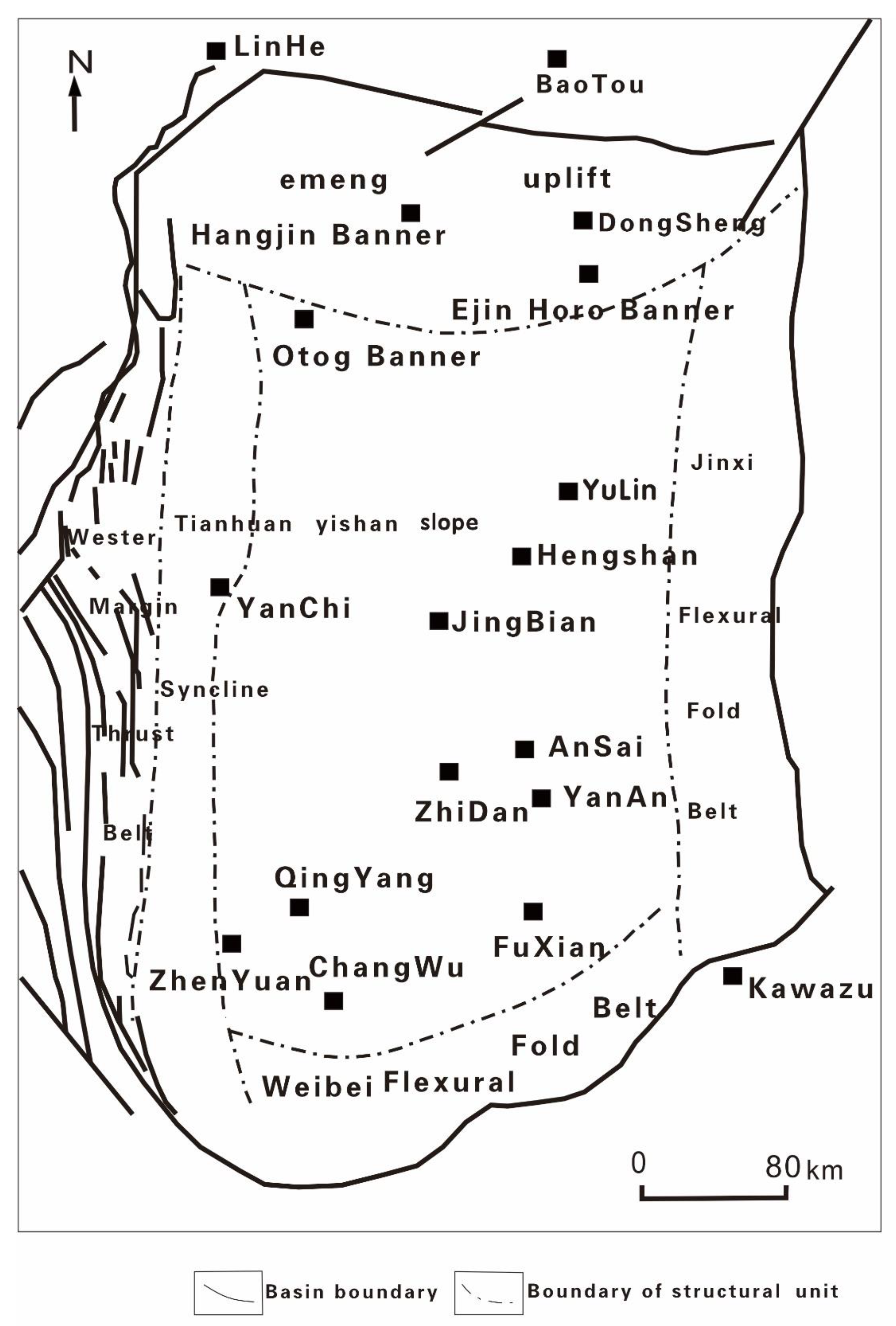
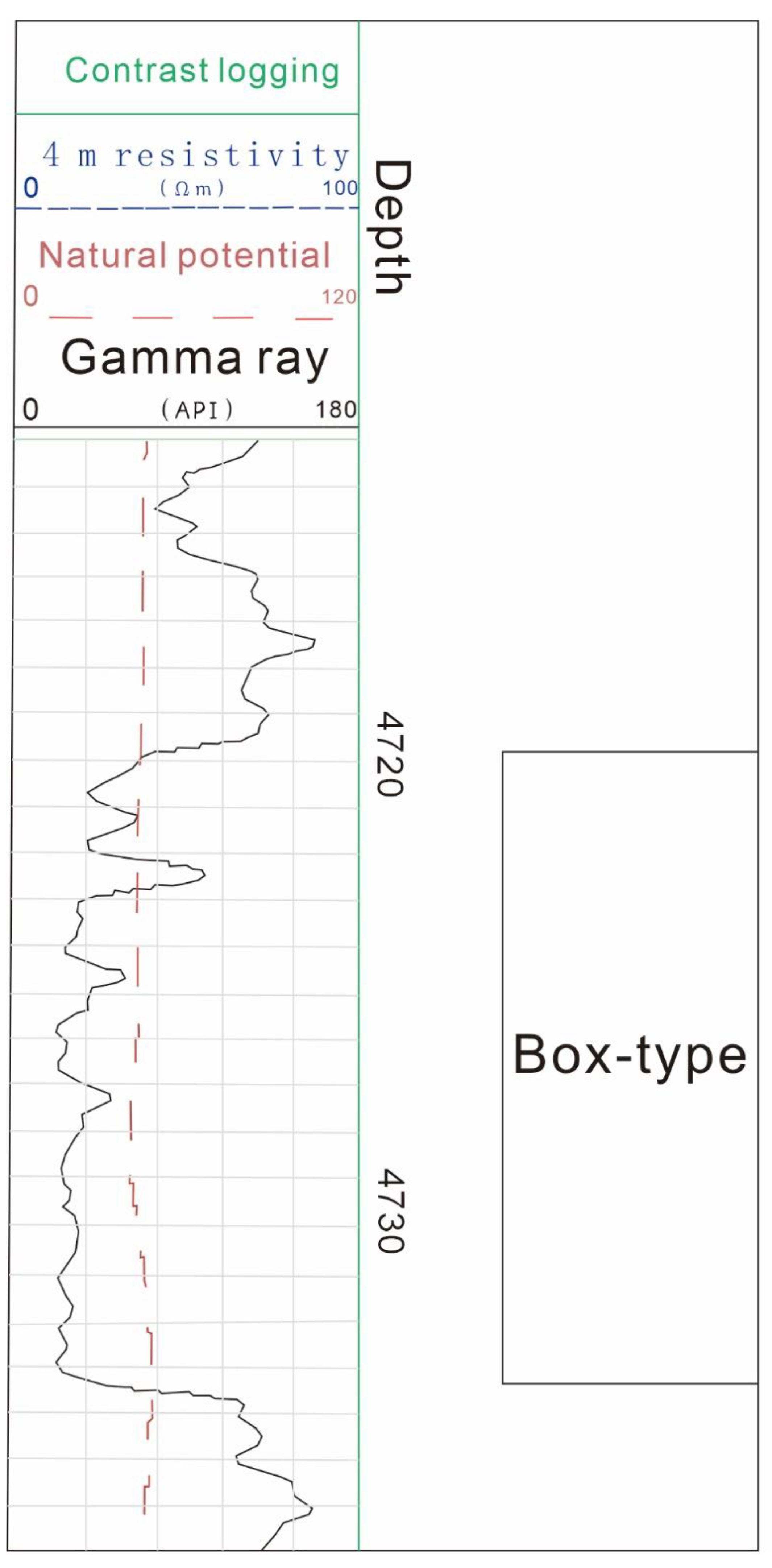
Figure 3.
Box-type GR curve of Well Qingtan 4.
Disclaimer/Publisher’s Note: The statements, opinions and data contained in all publications are solely those of the individual author(s) and contributor(s) and not of MDPI and/or the editor(s). MDPI and/or the editor(s) disclaim responsibility for any injury to people or property resulting from any ideas, methods, instructions or products referred to in the content. |
© 2024 by the authors. Licensee MDPI, Basel, Switzerland. This article is an open access article distributed under the terms and conditions of the Creative Commons Attribution (CC BY) license (http://creativecommons.org/licenses/by/4.0/).
Copyright: This open access article is published under a Creative Commons CC BY 4.0 license, which permit the free download, distribution, and reuse, provided that the author and preprint are cited in any reuse.


