
Submitted:
24 October 2024
Posted:
26 October 2024
You are already at the latest version
Abstract
Coastal ecosystems are crucial in mitigating the impact of coastal hazards on society. However, the paucity of information about the purpose of these ecosystems in reducing floods in Rivers State, Nigeria. This study aims to assess the contribution of mangrove ecosystems in protecting coastal communities from flooding using the InVEST coastal vulnerability model (version 3.10.2). The model analyzes various data inputs and assigns relative numbers, ranging from 1 to 5, indicating different levels of exposure. Data on population, bathymetry, shoreline type, land use land cover, and continental shelf were obtained from relevant websites and the InVEST model package. The findings indicate that the mangrove ecosystems in River State offer minimal protection against coastal flooding due to their degraded state caused by oil spills and over-exploitation. Additionally, sandy beaches provide little to no protection, and the socio-economic conditions in the communities contribute to increased vulnerability to flooding. The study recommends awareness programs to educate the public about the importance of mangroves for coastal protection in addition to their conservation and restoration.
Keywords:
coastal ecosystems
; disaster risk reduction
; climate adaptation
; nature-based solutions
1. Introduction
Coastal ecosystems are significant in reducing vulnerability to disasters. The link between ecological health and mitigating the risk of disasters has gained more global attention. Therefore, leading to the acknowledgement of Ecosystem-based disaster risk reduction as a crucial strategy for increasing resilience and reducing risk in the global outline for reducing disasters from 2015 to 2030 [59]. This is one of the significant developments since the preceding international framework for DRR plans. Other significant development includes the inclusion of new hazards, i.e., technological and biological; a multi-stakeholder approach to DRR; and a change of focus to preparedness and prevention [59]. Among these significant developments is the acknowledgement of the importance of ecosystems in risk assessments, which aids stakeholders in visualizing the relationship between ecosystem health and disaster reduction [17]. The increased consciousness notwithstanding, models that create scenarios of different ecosystem conditions are limited and not readily accessible to stakeholders [9] therefore resulting in the increase of integrated models [23]. Consequently, spatial models are been utilized extensively in the management of ecosystems and ecological health assessments [13, 61]. This has given rise to the advancement of spatial methods used in assessing the benefits of ecosystems and its application to development planning which was facilitated by the 2005 Millennium Environmental Assessment [5, 27, 37]. This has aided in marine-protected policies and decision-making in Haiti, the Great Bahamas, and the Republic of Congo [ 16, 60].
Despite being the most populated regions on Earth, coastal regions are growing increasingly vulnerable as a consequence to the changing climatic weather [29]. The populations whose sources of livelihood depend solely on marine and coastal ecosystems are most affected by these impacts [45]. As a result, communities that rely on these ecosystems for recreational opportunities, food production, economic development, and shoreline security negatively impacted [56]. With increasing urbanization, climate and population growth, the threat to ecosystems would also increase [48]. As a result, biodiversity and ecosystem services are lost [4].
A study by [47] reported on the initiatives to support communities in acclimatizing to the changing climate through nature-based solutions. NbS leverages biodiversity and the benefits of ecosystems in alleviating the impacts of the changing climate [10], leading to economic growth and conservation of coastal habitats [24]. The European Union and International Union on Conservation of Nature influenced the concept of solutions inspired by nature among the scientific community. This idea of NbS originated from dialogues on ecosystem services, green infrastructure, and climate adaptation [30]. The ability to reduce climate vulnerability sets NbS aside from anthropogenic solutions [11]. Several societal concerns, including food security, climate crisis and flooding, are been mitigated using NbS [6, 7]. As an emerging concept, NbS encompasses all the approaches that leverage a healthy ecosystem in shielding individuals and properties from the impacts of a changing climate. They include ecosystem-based adaptation, ecotourism, blue and green infrastructure and economy. Thus, increasing their capacity to reduce disaster and increase resilience in rural and urban regions [31].
One of the existential threats of a changing climate has been observed in increased temperature [14]). This affects people, ecosystem functions and biodiversity, in addition to impacts fromincreased urbanization, land use degradation and deforestation [19]. However, NbS can be used to combat these social challenges [32]. Climate change is defined as any change that contributes to anthropogenic activities that alter the arrangement of the global atmosphere while also influencing climatic fluctuations in nature which is observed for a period of time [58]. These changes can be seen in irregularities in temperature and rainfall patterns [1] which negatively impact coastal and marine ecosystems.
Nigeria is home to the largest and third-largest mangrove forests in Africa and globally, respectively [52]. According to studies, mangrove forests are the most intensively used globally [22], with a greater portion situated in the Niger Delta region. An earlier study by [36] highlighted oil spills, overexploitation and deforestation as contributory factors to mangrove deforestation and degradation. With the increasing global awareness of NbS to flooding, more studies are required to deepen the knowledge of the protective role mangroves offer in flood reduction and to justify the awareness creation, especially in Rivers State of Nigeria. An analysis by [42], reported a decline in the mangrove forests of the area, which decreases their protective role and reduces coastal resilience. Although previous studies have focused on; assessing ecological vulnerability [33], drivers of vulnerability [21], flood vulnerability [40], vulnerability index [42], coastal vulnerability assessment [41] and impact of oil spillage on the ecosystems, in the Niger Delta area, however, no study has assessed the role of mangroves in flood reduction in the region. It is against this background that this study aimed to use the InVEST CV model to assess the role of mangroves in flood reduction. The Natural Capital Project (NatCap Project) developed the model, which is software that enables stakeholders to visualise disaster risk under various ecosystem conditions [54]. This model is scenario-driven and offers scientifically based data on how ecosystem condition influences exposure to flood risk [27; 37], thereby making it an appropriate tool for Eco-DRR and CCA. It has a user-friendly interface that allows for a variety of modelling and data proficiency [12].
2. Materials and Methods
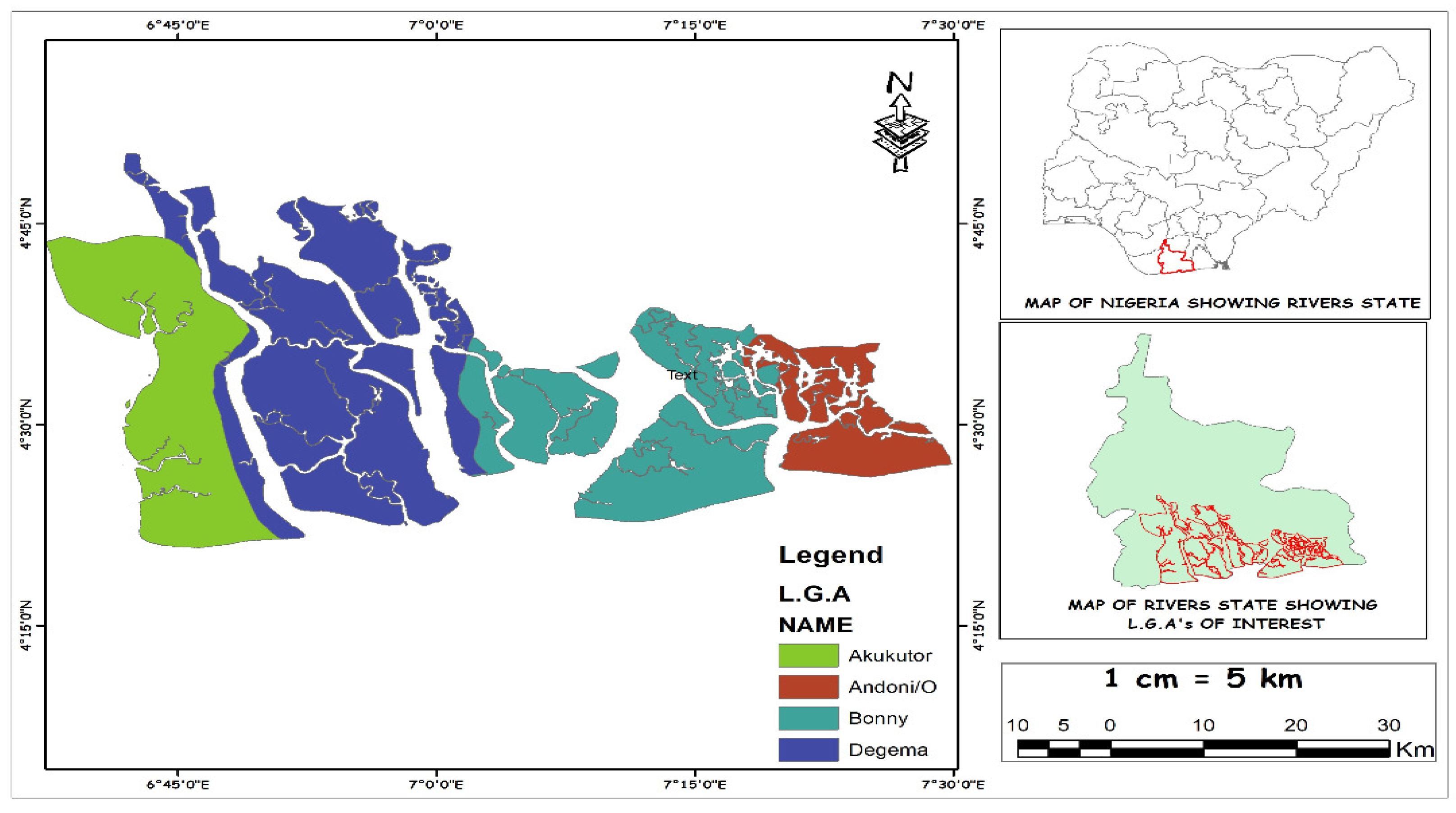
One of the largest deltas in Africa is situated in the South-Eastern part of Nigeria [15]. Geographically, it is low-lying and covers about 2.8% of the landmass, with its northern part extending south of Onitsha, a western portion bordering the estuary of the Benin River, and an eastern part abutting the estuary of the Imo River. The climate is affected by both the dry and warm northeast airmass that blows across the country from November to February and the warm and wet southwest air mass that brings rain from March to October. The region also experiences seasons of storm surges between the months of November and February.
Figure 1.
Map of Nigeria showing Rivers State and the study area.
Coastal Exposure
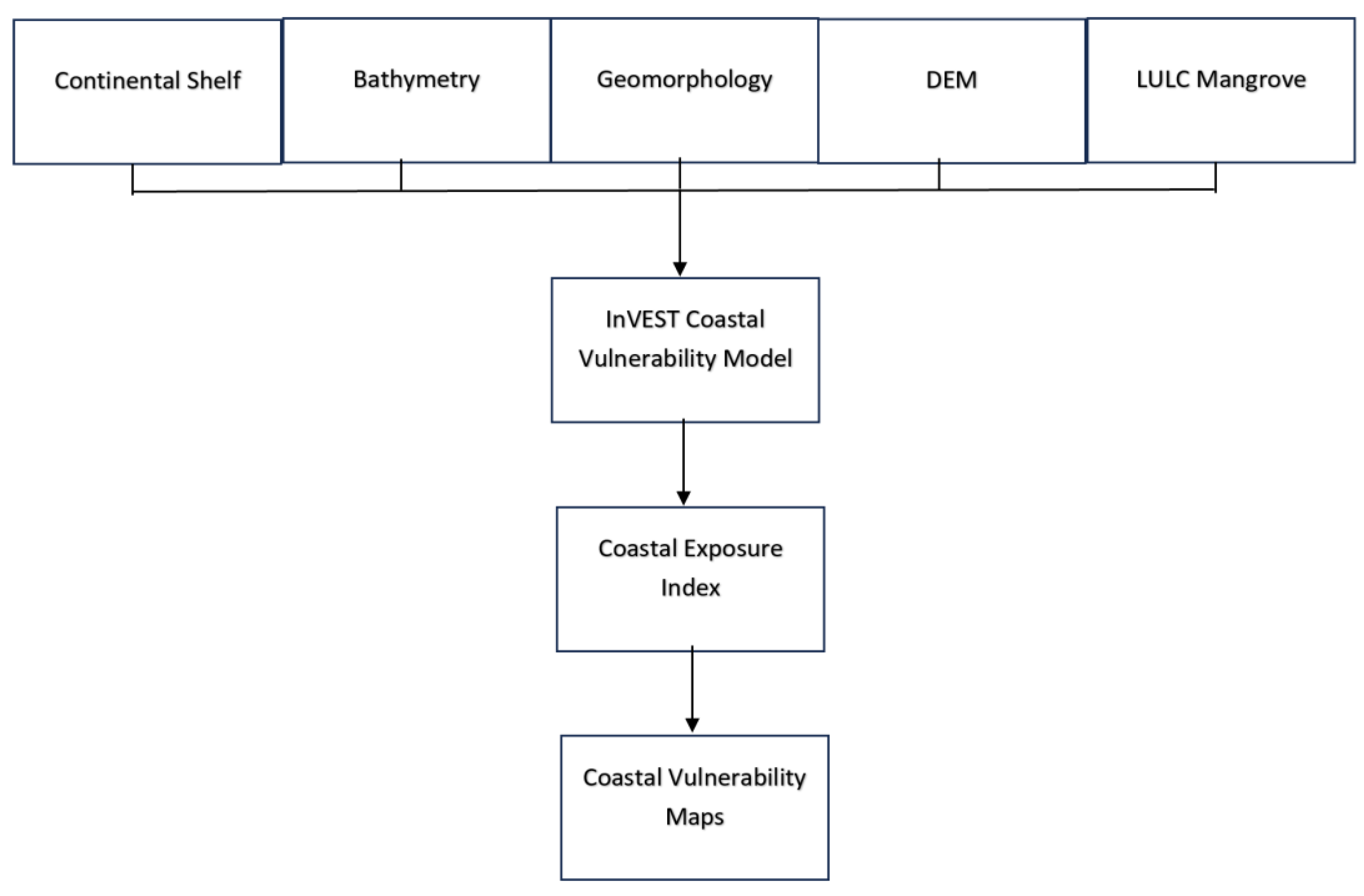
The InVEST CV model, version 3.10.2 was used in the study to evaluate the coastal exposure along Rivers State coast (Natural Capital Project 2014). The objective was to evaluate the contribution of mangrove ecosystems to flood reduction in coastal areas. The model was used to pinpoint communities that are more exposed to flood and regions where mangroves have the best chance to shield coastal residents from flood. The main output is a vulnerability map showing areas of low, intermediate, and high exposure (Fig 4). The InVEST CV model was used as it (1) considers the biological and geophysical aspects of the region and (2) has a minimal data requirement suitable for data-poor countries. The model is based on the assumption that coastal ecosystems provide a strong defence against flood risk [43], and this ranking is based on the understanding that healthy ecosystems provide more protection than degraded ecosystems [20]. It also assumes that ecosystems that penetrate the water column like the mangroves offer greater protection than the weak and seasonal ecosystems like the salt marshes [26]. The model inputs include raster and shapefiles of bathymetry, natural habitat, continental shelf, shoreline geomorphology, and digital elevation model (DEM) (see Table 1) whereas the outputs are the vulnerability maps (see Figs 4,5 and 6).
Figure 2.
Flowchart on the inputs and outputs of the InVEST CV model.
Coastal Exposure Index
A qualitative index that grades coastal areas based on relative exposure is produced by the model. It incorporates various observed data on wind, wave, digital elevation model, and geomorphology to evaluate the impact of floods on exposure; SLR and ecosystem types are optional variables. The geometric average of each variable rankings—which ranges from lowest, with rank as 1 and highest, with rank as 5—was used to determine the coastal exposure.

Eqn. 1
where R signifies the numerical assessment of the biogeographical variables. All variables are weighed equally, which is one of the limitations of the model [39].
Figure 3.
Exposure of the shoreline segments to various scenarios of habitat condition.

3. Results
This section may be divided by subheadings. It should provide a concise and precise description of the experimental results, their interpretation, as well as the experimental conclusions that can be drawn.
3.1. Exposure with Current Habitat Conditions
About 77 % of the research region is extremely susceptible to flooding under the existing ecological conditions, compared to 18 % who are just slightly exposed and 5 % who are barely affected (Fig 4).
3.2. Exposure with Habitat Scenario
The "exposure with mangrove" scenario will offer more protection. When this scenario was compared to the 'current ecosystem condition' scenario, it was discovered that there would be less exposure along the whole coastline. The percentage of low exposure increased to 100%. (Fig 6). Lower exposure is particularly important at the state's sandy beaches.
3.3. Exposure without Habitat Scenario
To determine how mangroves reduce a community's vulnerability to floods, exposure under current and without mangrove scenarios were compared. In contrast to the existing situation, the whole coastline would be highly exposed without mangroves; 92% of it would be vulnerable to coastal flooding, and only 1% would be at minimal risk (Fig 5). Most of the communities are classified as being at high risk of floods.
The area's mangrove habitats are deteriorating, which is why exposure has increased. The primary causes of mangrove deterioration in the study area are incidents of oil spills and over-exploitation of mangroves.
Figure 4.
A vulnerability map of the “current condition” scenario.

Figure 5.
A vulnerability map of the "without mangrove" scenario.
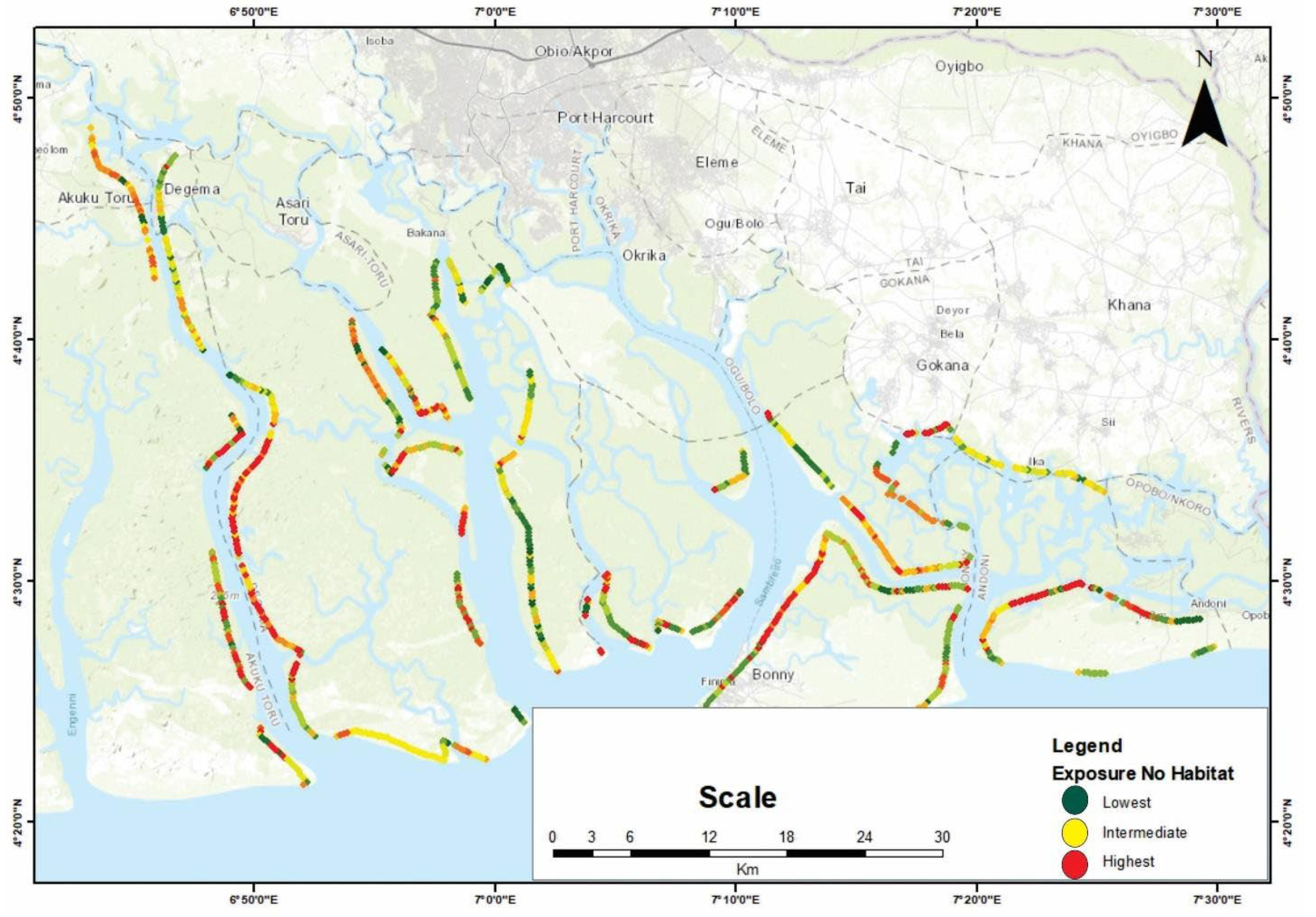
Figure 6.
A vulnerability map of the "with mangrove" scenario.

The 3 scenarios showed varying degrees of protection offered by the mangroves. The findings indicate that the mangroves provide minimal protection in the event of flood. Exposure to coastal flooding was high under the without mangrove scenario (92%), followed by “current condition” of the ecosystem (77%) and with ecosystem scenario (0%). This could be as a result of the deplorable state of the mangrove ecosystem as reported by [42], who cited a reduction in the volume of mangroves thereby leading to low resilience in their protective role. Previous studies had cited high exposure to disaster risk in the absence of ecosystems [3, 8, 53], which agree to the results obtained from this study.
The “with ecosystem” scenario showed the lowest exposure as this scenario assumes that the mangroves are in its pristine state and therefore provide maximum protection in the event of flood. The lowest exposure was recorded under the “with mangrove” scenario (0) while exposure under the “current condition” of the ecosystem was highest followed by the without mangrove scenario (1%) and “current condition” of the ecosystem (5%). This scenario assumes that the mangrove ecosystems provide maximum protection in the event of flood risk hence the low exposure. This result aligns with earlier findings by [2, 3, 8, 44, 50]. This shows the protective role offered by the mangrove ecosystem in the event of flood risk. The study's findings can be used as a disaster risk management as a tool for decision-making. The research area would experience more severe flood impacts if ecosystems were lost, but their restoration would increase protection, according to a comparison of ecosystem management scenarios.
According to this study, the mangrove ecosystems are threatened by unsustainable activities. The InVEST model's results will help build resilient, sustainable land use plans and coastal zoning policies. They can also increase public awareness of the protective role that mangroves play in shielding people and property from the hazards of disaster. The advantages that coastal ecosystems offer for tourism and real estate development were noted in the findings of a study by [35] which is in line with the manual by NatCap [57]; nevertheless, this relationship has not yet reached its full potential in this study area. If the current ecosystems in Rivers State continue to deteriorate, the study's findings can be utilized to pinpoint regions where potential investments may be lost. The outcomes may also promote tourism and mangrove conservation. It can be utilized to determine the optimal regions to focus on for Eco-DRR projects because it also illustrates areas where ecosystems can reduce hazards efficiently and where populations benefit more from the defence provided by ecosystems [34].
5. Conclusions
The results show that these coastal ecosystems provide limited protection in the case of flood risk. However, the diverse scenarios indicated the places where ecosystems can give maximum protection, areas of exposure and prospects for conservation, afforestation, and restoration. Therefore, the authors propose the use of InVEST CV model in disaster reduction (DRR) decisions by stakeholders. It also suggests programmes on restoration, afforestation, and conservation of mangroves in the state while also sensitizing the indigenes on the benefits of mangroves. Although these findings highlight the protective role of mangroves, it does not however propose that coastal habitats unaided are adequate to safeguard people in addition to properties from coastal flooding. Therefore, a more complete review is vital to discover a suitable solution.
6. Patents
Author Contributions
Chinomnso, C. Onwubiko.: conceptualization, writing - original draft, review and editing, methodology, data curation, visualization, formal analysis. Denis, W. Aheto.: conceptualization, review and editing, resources, supervision.
Funding
This research is part of the doctoral thesis of the first author which was funded by the World Bank through the African Centre of Excellence in Coastal Resilience (ACECoR), Centre for Coastal Management, University of Cape Coast, Ghana. Grant Number is credit number 6389-G.
Institutional Review Board Statement
This study was approved by the Institutional Review Board of the University of Cape Coast (UCCIRB/CANS/2022/03).
Informed Consent Statement
Informed consent was obtained from all subjects involved in the study.
Data Availability Statement
All data used in this study are displayed above.
Acknowledgments
The author are grateful to the World Bank through the African Centre of Excellence in Coastal Resilience (ACECoR), Centre for Coastal Management and the Department of Fisheries and Aquatic Science, University of Cape Coast, Ghana, for providing funds for this study.
Conflicts of Interest
The authors declare no conflicts of interest.
References
- [1] Adopted IPCC, (2014). Climate change 2014 synthesis report. IPCC: Geneva, Switzerland, 1059- 1072.
- [2] Ai, B., Tian, Y., Wang, P., Gan, Y., Luo, F., & Shi, Q., (2022). Vulnerability Analysis of Coastal Zone Based on InVEST Model in Jiaozhou Bay, China. Sustainability, 14(11), 6913. [CrossRef]
- [3] Arkema, K.K., Guannel, G., Verutes, G., Wood, S.A., Guerry, A., Ruckelshaus, M., & Silver, J.M., (2013). Coastal habitats shield people and property from sea-level rise and storms. Nature climate change, 3(10), 913-918.
- [4] Artmann, M., & Breuste, J., (2015). Cities built for and by residents: Soil sealing management in the eyes of urban dwellers in Germany. Journal of Urban Planning and Development, 141(3), A5014004.
- [5] Assessment, M.E., (2005). Ecosystems and human well-being: current state and trends.
- [6] Balian, E., Eggermont, H., & Le, Roux, X., (2014). Outputs of the strategic foresight workshop ‘‘nature-based solutions in a BiodivERsA context’’. In Brussels: BiodivERsA Workshop Report.
- [7] Bauduceau, N., Berry, P., Cecchi, C., Elmqvist, T., Fernandez, M., Hartig, T., & Tack, J., (2015). Towards an EU research and innovation policy agenda for nature-based solutions & re-naturing cities: Final report of the horizon 2020 expert group on nature-based solutions and re-naturing cities.
- [8] Bayani, N., & Barthélemy, Y., (2016). Integrating ecosystems in risk assessments: Lessons from applying InVEST models in data-deficient countries. Ecosystem-based disaster risk reduction and adaptation in practice, 227-254.
- [9] Beck, M., Gilmer, B., Ferdana, Z., Raber, G.T., Shepard, C., Meliane, I, & Newkirk, S., (2013). Increasing the resilience of human and natural communities to coastal hazards: supporting decisions in New York and Connecticut. The role of ecosystems in disaster risk reduction, 140-163.
- [10] CBD, (2019). Voluntary guidelines for the design and effective implementation of EbA to climate change adaptation and disaster risk reduction and supplementary information. In: CBD Technical Series No.93 Secretariat the Convention on Biological Diversity(93). https://www.cbd.int/doc/publications/cbd-ts-93-en.pdf.
- [11] Cohen-Shacham, E., Walters, G., Janzen, C., & Maginnis, S. (2016). Nature-based solutions to address global societal challenges. IUCN: Gland, Switzerland, 97, 2016-2036.
- [12] Daily, G.C,, Kareiva, P.M., Polasky, S., Ricketts, T.H., & Tallis, H. (2011). Mainstreaming natural capital into decisions. In: Kareiva P, Tallis, H., Ricketts, T.H., Daily, G.C., Polasky, S., (eds). Natural capital: theory and practice of mapping ecosystem services. Oxford University Press, Oxford. Kindle Edition.[13] DeFries, R., Pagiola, S., Adamowicz, W.L., Akcakaya, H.R., Arcenas, A., Babu, S., ... & Thönell, J., (2005). Analytical approaches for assessing ecosystem condition and human well-being. Ecosystems and human well-being: current state and trends, 1, 37-71.[1][1]9.
- [14] Desa, UN. World urbanization prospects: The 2014 revision. United Nations Department of Economics and Social Affairs. Population Division: New York, NY, USA. 2015;41.
- [15] Durotoye, A., 2000. "The Nigerian State at a Critical Juncture: The Dilemma of a Confused Agenda". University of Leipzig Paper on Africa, Politics and Economic Series (38):1-28.
- [16] EME, [Evaluacio´n de los Ecosistemas del Milenio de Espa~na] (2011) Sı´ntesis de resultados. Fundacio´n Biodiversidad. Ministerio de Medio Ambiente, y Medio Rural y Marino. Madrid: Spain.
- [17] Estrella, M., Renaud, F.G., & Sudmeier-Rieux, K., (2013). Opportunities, challenges, and future perspectives for ecosystem-based disaster risk reduction.
- [18] European Commission, (2000). Directive 2000/60/EC of the European Parliament and of the Council of 23 October 2000 establishing a framework for community action in the field of water policy. Official Journal of the European Communities L 327: 1–72.
- [19] European Environment Agency, (2012). Climate change, impacts and vulnerability in Europe 2012: an indicator-based report. Office for Official Publ. of the Europ. Union.
- [20] European Union, (2014). Mapping and assessment of ecosystems and their services: indicators for ecosystem assessments under Action 5 of the EU Biodiversity Strategy to 2020. 2nd Report. February 2014. http://ec.europa.eu/environment/nature/knowledge/ecosystem_assessment/pdf/2ndMAESWorkingPaper.pdf. Accessed 28 Apr 2015.
- [21] Fadairo, O., Olajuyigbe, S., & Adelakun, O., (2023). Drivers of vulnerability to climate change and adaptive responses of forest-edge farming households in major agro-ecological zones of Nigeria. GeoJournal 88, 2153–2170 (2023). [CrossRef]
- [22] FAO, 1997. Management and Utilization of the Mangroves in Asia and the Pacific. FAO. Rome, pp: 319.
- [23] GFDRR, [Global Facility for Disaster Reduction and Recovery] (2014). Review of open source and open access software packages available to quantify risk from natural hazards. International Bank for Reconstruction and Development, The World Bank, Washington, DC.
- [24] Goddard, M.A., Dougill, A.J., & Benton, T.G., (2010). Scaling up from gardens: biodiversity conservation in urban environments Trends in Ecology & Evolution 25(2):90-98. [CrossRef]
- [25] Gornitz, V., (1990). Vulnerability of the East Coast, USA to future sea level rise. Journal of Coastal research, 201-237.
- [26] Guannel, G., Ruggiero, P., Faries, J., Arkema, K., Pinsky, M., Gelfenbaum, G., & Kim, C.K., (2015). Integrated modeling framework to quantify the coastal protection services supplied by vegetation. Journal of Geophysical Research: Oceans, 120(1), 324-345.
- [27] Guerry, A.D., Ruckelshaus, M.H., Arkema, K.K., Bernhardt, J.R., Guannel, G., Kim, C.K, & Spencer, J., (2012). Modeling benefits from nature: using ecosystem services to inform coastal and marine spatial planning. International Journal of Biodiversity Science, Ecosystem Services & Management, 8(1-2), 107-121.
- [28] Hammar-Klose, E.S., & Thieler, E.R., (2001). Coastal vulnerability to sea-level rise: a preliminary database for the US Atlantic, Pacific, and Gulf of Mexico coasts (No. 68). US Geological Survey.
- [29] Harley, C.D., Randall, Hughes, A., Hultgren, K.M., Miner, B.G., Sorte, C.J., Thornber, C.S., & Williams, S.L., (2006). The impacts of climate change in coastal marine systems. Ecology letters, 9(2), 228-241.
- [30] Kabisch, N., Frantzeskaki, N., Pauleit, S., Naumann, S., Davis, M., Artmann, M., & Bonn, A., (2016a). Nature-based solutions to climate change mitigation and adaptation in urban areas: perspectives on indicators, knowledge gaps, barriers, and opportunities for action. Ecology and society, 21(2).
- [31] Kabisch, N., Frantzeskaki, N., Pauleit, S., Naumann, S., Davis, M., Artmann, M., & Bonn, A., (2016b). Nature-based solutions to climate change mitigation and adaptation in urban areas: perspectives on indicators, knowledge gaps, barriers, and opportunities for action. Ecology and society, 21(2).
- [32] Kabisch, N., Korn, H., Stadler, J., & Bonn, A., (2017). Nature-based solutions to climate change adaptation in urban areas: Linkages between science, policy, and practice. Springer Nature.
- [33] Kamalu, O.J., & Wokocha, C.C., (2011). Land resource inventory and ecological vulnerability: Assessment of Onne area in Rivers State, Nigeria. Research journal of environmental and earth sciences, 3(5), 438-447.
- [34] Langridge, S.M., Hartge, E.H., Clark, R., Arkema, K., Verutes, G.M., Prahler, E.E., ... & O'Connor, K., (2014). Key lessons for incorporating natural infrastructure into regional climate adaptation planning. Ocean Coastal Management, 95, 189-197.
- [35] McKenzie, E., Irwin, F., Ranganathan, J., Hanson, C., Kousky, C., Bennett, K., ... & Paavola, J., (2011). Incorporating ecosystem services in decisions. Natural capital: theory and practice of mapping ecosystem services. Oxford University Press, Oxford, 339-355.
- [36] Mmom, P.C., & Arokoyu, S.B., (2010). Mangrove Forest depletion, biodiversity loss and traditional resources management practices in the Niger Delta, Nigeria. Research Journal of Applied Sciences, Engineering and Technology, 2(1), 28-34.
- [37] Mooney, P.F., (2011). The effect of human disturbance on site habitat diversity and avifauna community composition in suburban conservation areas. Ecosystems and Sustainable Development, 13- 26.
- [38] United Nations, (2014). World urbanization prospects: The 2014 revision, highlights. department of economic and social affairs. Population Division, United Nations, 32.
- [39] Natural Capital Project, (2014). InVEST coastal vulnerability model 3.0.0 documentation http://www.naturalcapitalproject.org/models/coastal_vulnerability.html.
- [40] Ologunorisa, T.E., (2004). An assessment of flood vulnerability zones in the Niger Delta, Nigeria. International journal of environmental studies, 61(1), 31-38.
- [41] Oloyede, M.O., Williams, A.B., Ode, G.O., & Benson, N. U., (2022). Coastal vulnerability assessment: A case study of the Nigerian coastline. Sustainability, 14(4), 2097.
- [42] Omo-Irabor, O, Olobaniyi, S.B. Akunna, J., Venus, V., Maina, J.M., & Paradzayi, C., (2011). Mangrove vulnerability modelling in parts of Western Niger Delta, Nigeria using satellite images, GIS techniques and Spatial Multi-Criteria Analysis (SMCA). Environmental monitoring and assessment, 178(1-4), 39- 33.
- [43] Peduzzi, P., Velegrakis, A., Estrella, M. & Chatenoux, B. (2013). Integrating the role of ecosystems in disaster risk and vulnerability assessments: Lessons from the Risk and Vulnerability Assessment Methodology Development Project (RiVAMP) in Negril, Jamaica. The role of ecosystems in disaster risk reduction, 109-139.
- [44] PLOS ONE Staff, (2015). Correction: future coastal population growth and exposure to sea-level rise and coastal flooding-a global assessment. PloS one, 10(6), e0131375.
- [45] Savo, V., Lepofsky, D., Benner, J.P., Kohfeld, K.E., Bailey, J., & Lertzman, K., (2016). Observations of climate change among subsistence-oriented communities around the world. Nature Climate Change, 6(5), 462-473.
- [46] Secretariat of the Convention on Biological Diversity, (CBD) (2019). Voluntary Guidelines for the Design and Effective Implementation of Ecosystem-based Approaches to Climate Change Adaptation and Disaster risk Reduction and Supplementary Information. CBD Technical Series No. 93.
- [47] Seddon, N., Smith, A., Smith, P., Key, I., Chausson, A., Girardin, C. & Turner, B., (2021). Getting the message right on nature- based solutions to climate change. Global change biology, 27(8), 1518-1546.
- [48] Seto, K. C., Fragkias, M., Güneralp, B., & Reilly, M. K. (2011). A meta-analysis of global urban land expansion. PloS one, 6(8), e23777.
- [49] Shah, M.A.R., Renaud, F.G., Anderson, C.C., Wild, A., Domeneghetti, A., Polderman, A, & Zixuan, W., (2020). A review of hydro-meteorological hazard, vulnerability, and risk assessment frameworks and indicators in the context of nature-based solutions. International journal of disaster risk reduction, 50, 101728.
- [50] Silver, J.M., Arkema, K.K., Griffin, R.M., Lashley, B., Lemay, M., Maldonado, S., Moultrie, S.H., Ruckelshaus, M., Schill, S., Thomas, A., Wyatt, K., & Verutes, G., (2019). Advancing Coastal Risk Reduction Science and Implementation by Accounting for Climate, Ecosystems, and People. Frontiers in Marine Science, 6, 556. [CrossRef]
- [51] Silver, J.M., Arkema, K.K., Griffin, R.M., Lashley, B., Lemay, M., Maldonado, S., Moultrie, S.H., Ruckelshaus, M., Schill, S., Thomas, A., Wyatt, K., & Verutes. G., (2019). Advancing Coastal Risk Reduction Science and Implementation by Accounting for Climate, Ecosystems, and People. Frontiers in Marine Science, 6, 556. [CrossRef]
- [52] Singh, S., & Singh, J.S., (1995). Microbial biomass associated with water-stable aggregates in forest, savanna and cropland soils of a seasonally dry tropical region, India. Soil Biology and Biochemistry, 27(8), 1027-1033.
- [53] Sutton-Grier, A.E. & Sandifer, P.A., (2019). Conservation of wetlands and other coastal ecosystems: a commentary on their value to protect biodiversity, reduce disaster impacts, and promote human health and well-being. Wetlands, 39(6), 1295-1302.
- [54] Tallis, H.T., Ricketts, T., Guerry, A.D., Nelson, E., Ennaanay, D., Wolny, S., ... & Sharp, R., (2011). InVEST 2.1 beta user’s guide. Integrated Valuation of Ecosystem Services and Tradeoffs.
- [55] Thieler, E.R., Hammar-Klose, S., (1999). National assessment of coastal vulnerability to future sea-level rise: preliminary results for the US Atlantic Coast [Internet]. US Geological Survey. Open-File Report. Available from: http://pubs.usgs.gov/of/of99-593/.
- [56] Thomas, A.S., Mangubhai, S., Vandervord, C., Fox, M., & Nand, Y., (2018). Impact of tropical cyclone Winston on women mud crab fishers in Fiji. Climate and Development 11, 699–709. doi:10.1080/17565529. 2018.1547677.
- [57] Turner, I.L., Harley, M.D., & Drummond, C.D., (2016). UAVs for coastal surveying. Coastal Engineering, 114, 19-24.
- [58] UNFCCC, (2011). National Adaptation Programmes of Action. (http://unfccc.int/national_reports/napa/items/2719.php. [20 January 2014]).
- [59] UNISDR, C., (2015). The human cost of natural disasters 2015: A global perspective Umechuruba, C.I. (2005). Health impact assessment of mangrove vegetation in an oil spilled site at the Bodo West field in Rivers State, Nigeria. Journal of Applied Sciences and Environmental Management, 9(1), 69-73. Agency for International Development.
- [60] Watson, R., Albon, S., Aspinall, R., Austen, M, Bardgett, B, Bateman, I., ... & Winter, M., (2011). UK National Ecosystem Assessment: understanding nature's value to society. Synthesis of key findings.
- [61] Yang, M.G.M., Hong, P., & Modi, S.B., (2011). Impact of lean manufacturing and environmental management on business performance: An empirical study of manufacturing firms. International Journal of production economics, 129(2), 251-261.

Table 1.
The data requirements used in the CV model.
| Model inputs | Year | Extent | Resolution (m) | Sources |
|---|---|---|---|---|
|
Natural habitats (LULC Mangroves accessed in 2020) |
2020 | Rivers State | 30 | http://sedac.ciesin.columbia.edu/data/set/lulc-global-mangrove-forests-distribution-2000 |
|
Digital Elevation Model (DEM) |
2022 | Global | 30 | (https://earthexplorer.usgs.gov/) |
| Wind/ Wave data | 2005-2010 | Global | - | National Oceanic and Atmospheric Administration |
|
Coastal Geomorphology (Shoreline type) |
2022 | Rivers State | 30 | NGSA (Nigeria Geological Survey Agency) |
|
Global land mass polygon shapefile |
2016 | Global | 30 | Made with Natural Earth. Free vector and raster map data @ naturalearthdata.com (Wessel and Smith, 1996) |
Disclaimer/Publisher’s Note: The statements, opinions and data contained in all publications are solely those of the individual author(s) and contributor(s) and not of MDPI and/or the editor(s). MDPI and/or the editor(s) disclaim responsibility for any injury to people or property resulting from any ideas, methods, instructions or products referred to in the content. |
© 2024 by the authors. Licensee MDPI, Basel, Switzerland. This article is an open access article distributed under the terms and conditions of the Creative Commons Attribution (CC BY) license (http://creativecommons.org/licenses/by/4.0/).
Copyright: This open access article is published under a Creative Commons CC BY 4.0 license, which permit the free download, distribution, and reuse, provided that the author and preprint are cited in any reuse.


