

Submitted:
09 October 2024
Posted:
10 October 2024
You are already at the latest version
Abstract
The thickness estimation is crucial for evaluating landslide evaluating. The traditional non-contact mass conservation method adopts three-dimensional deformation to estimate landslide thickness, which may be unsuitable due to the limitations of observations. In this study, a more feasible approach for estimating landslide thickness based on 2D deformation derived from two-track Interferometric Synthetic Aperture Radar (InSAR) observations is proposed, specifically applied to the Xiongba landslide. The comparison between the estimated thickness from the InSAR-derived 2D deformation and the measured thickness by geological and drilling methods validates the reliability of the proposed method. The mapped InSAR LOS deformation rate fields reveal two distinct deformation regions, including a frontal zone exhibiting significant deformation and a relatively stable zone. The analysis of the 2D deformation indicates that surface uplift at the front edge of the Xiongba-H2 landslide may result from the pushing of the rock-soil mass in areas of high deformation. The inversion result suggests that the thickness of the Xiongba-H2 landslide is ranging from 10 to 100 m, corresponding to the active volume of 6.17×10⁷ m3. A thicker region is identified, at the front edge along the Jinsha River, posing the potential of further failure. It is believed that the proposed low-cost, easily implementable approach could enhances the applicability of InSAR technology for landslide motion analysis and hazard assessment.
Keywords:
InSAR-derived 2D deformation
; improved mass conservation method
; landslide thickness
; rheological parameter
; the Xiongba Landslide
1. Introduction
The slow-moving landslide is a typical geological disaster, commonly occurring in the mountainous regions of western China. The failure of slow-moving landslides can cause significant casualties and substantial property losses, while also providing ample material for debris flows, particularly during the rainy season, potentially leading to severe cascading geological disaster events. (Nadim et al., 2006; Petley et al., 2012). Therefore, it is imperative to monitor the surface movement velocity and volume of landslides, with particular emphasis on landslide thickness, as it directly influences the estimation of landslide volume and hazard extent, serving as a critical factor in landslide risk assessment (Guzzetti et al., 2009). However, the detection of landslide thickness poses significant challenges, primarily because it is often not possible to access the underlying base surface of the landslide.
Two primary approaches exist for estimating active thickness are the contact and non-contact methods. Contact methods rely on direct on-site measurements, typically utilizing inclinometer detection (Simeoni et al., 2007; Stark et al., 2008) or ground-penetrating radar techniques (Delbridge et al., 2016). However, contact detection methods are limited to measuring the thickness at specific points rather than across the entire landslide, due to the significant financial and time constraints involved (Mora et al., 2003), making it unsuitable for assessing large-scaleand mega-landslides.
As developed, several non-contact methods are proposed, including the equilibrium cross-section method (Bishop, 1999; Aryal et al., 2015), the dislocation method (Nikolaeva et al., 2014), and the mass conservation method (Booth et al., 2013b; Huang et al., 2017). The equilibrium cross-section method assumes that landslide material behaves as incompressible rigid bodies, neglecting the influence of rheological properties, which leads to a less reliable estimation of landslide thickness (Rowan et al., 1989; Zhang et al., 2014). The dislocation theory method simplifies both the geometric configuration and the physical mechanisms of the landslide. Consequently, its application is limited to the initial stage of landslide development or landslides without significant inelastic deformation (Feigl et al., 1999; Aryal et al., 2015). The mass conservation approach is an emerging approach that integrates surface deformation and rheological properties to estimate the thickness of a moving body. This method has been widely applied in landslide and glacier thickness calculations (Farinotti et al., 2009; Morlighem et al., 2011; Booth et al., 2013; Hu et al., 2018; Handwerger et al., 2021), and is considered a reliable and practical approach for landslide thickness detection (Handwerger et al., 2021; Yang et al., 2021). In this method, the rate of thickness variation is balanced with the divergence of horizontal mass flux across the landslide surface. And the landslide depth can be calculated by integrating along the basal sliding surface with dynamic boundary conditions. However, its implementation requires three-dimensional deformation fields and accurate rheological parameters, which can be difficult to obtain, particularly in remote areas (Booth et al., 2013; Delbridge et al., 2016; Hu et al., 2016; Nguyen et al., 2016).
In this study, an improved mass conservation approach is developed to detect landslide thickness based only on the ascending and descending orbital tracks InSAR observations. The developed method can be used to infer the landslide thickness based on the decomposed 2D deformation along the slope and normal directions. This method is applied to the Xiongba ancient landslide in southwest China. Geological survey and drilling data are introduced to verify the reliability of the proposed method. Additionally, the best-fitting rheological parameters are determined based on the thickness data of sparse points.
2. Study Area and Dataset
2.1. Geologic Background of the Xiongba Ancient Landslide
The Xiongba ancient landslide is located in Shadong Township, Gongjue County, Tibet Autonomous Region, China, on the west bank of the Jinsha River (Figure 1). In this region, the Jinsha River runs predominantly in a north-south direction. The local terrain exhibits significant complexity, with elevations varying between 2600–4000 m. And the area is characterized by a continental plateau monsoon climate, with an average annual rainfall of 480 mm, the majority of which occurs between May and September. In addition, the Xiongba ancient landslide is situated within the Jinsha River seismic zone, which hosts several significant active faults, including the Jinsha River Fault and the Batang Fault, and has a history of frequent seismic activity (Jin et al., 2021).
The Xiongba ancient landslide presents a chair-shaped structure, and can be divided into three distinct regions according to the topographic feature (Figure 1b). The rear wall (Region I) of the landslide is characterized by steep terrain, with elevations ranging from 3359 to 3800 meters. The slope gradient generally varies between 40° and 45°, but occasionally exceeds 60–70°. Previous remote sensing interpretation and field geological surveys indicate that the rear wall region is generally stable (Yan et al., 2021). The central platform (Region II) features relatively flat terrain, primarily distributed at elevations between 3326–3534 m, with slopes ranging from 10° to 15°, and generally exhibits a stable disposition. The frontal deformed area (Region III) is the main portion of the ancient landslide, with elevations varying between 2693–3216 m, and is currently in a creeping state. The landslide extends ~2.13 km in length and ~2.68 km in width, covering an area of ~5.33 km2;, and the volume is estimated to be between 2.6×10⁸–6.0×10⁸ m3 (Li et al., 2021). Furthermore, the topographic features and deformation distribution indicate that the Xiongba ancient landslide consists of two secondary landslides of H1 and H2, as shown in Figure 1b. (Jin et al., 2021).
The bedrock of the Xiongba ancient landslide is mainly composed of mica-quartz schists of Permian-Lower Triassic Gangtoite Formation (PT1g). The sediment of the Xiongba landslide is mainly composed of Quaternary broken stone soil (Q4del), which contains approximately 50% crushed stone with particle sizes of 2~10 cm, 20% block stone with block diameter of 20~40 cm, and silty clay (Jin et al., 2021). And riverbed sediment of the Jinsha River is mainly composed of Quaternary alluvial-proluvial sand and gravel (Q4al+pl). Previous study suggested that the Xiongba landslide may fail along weak surfaces under the influence of localized heavy rainfall, potentially triggering a chain of disaster events, including river blockage and dam failure, which could seriously threaten the safety of surrounding villages (Li et al., 2021).
2.2. Ground Deformation of the Xiongba Landslide Extracted by InSAR Time-Series Analysis
In this study, 59 ascending track and 68 descending track radar images (Coverage and detailed parameters can be found in Figure 1a and Table S1) captured by the Sentinel-1 satellite were collected to map the deformation fields of the Xiongba landslide. The Precise Orbit Ephemerides (POD) data provided by European Space Agency (ESA) was employed to refine satellite orbit vectors. The SRTM Digital Elevation Model (DEM) data with 30 m resolution was applied to remove the topography phase component from the interferograms. And the minimum cost flow algorithm was adopted to unwrap the interferogram (Costantini et al., 1999; Pepe et al., 2011). The Generic Atmosphere Correction Online Service for InSAR (GACOS) data were used to correct for atmospheric delays.
The SBAS-InSAR technique was applied to extract the surface InSAR velocity fields (Figure 2) of the Xiongba landslide based on the collected ascending and descending SAR images, in which a combination of high-pass and low-pass filtering operations were performed to further mitigate the atmospheric delay errors (Berardino et al., 2002). The temporal and spatial baselines were set to 120 days and 300 meters, respectively, resulting in 445 and 587 interferometric pairs for the ascending and descending InSAR tracks. Considering that the GNSS data is lacking, the absolute mean of the InSAR observations in the relatively stable zone, far away from the landslide, is calculated to quantitatively assess the uncertainty of the observed InSAR deformation. And it is found that the uncertainties of 5.1 mm/yr and 5.7 mm/yr are respectively for the ascending and descending InSAR tracks. The millimeter-level accuracy mentioned above indicates that the extracted InSAR observations are sufficiently reliable for further revealing the surface motion of the Xiongba-H2 landslide.
Figure 2a,b show notable differences between the ascending and descending InSAR velocity fields of the Xiongba-H2 landslide in terms of deformation magnitude and spatial distribution, which could be attributed by the difference in imaging geometry between the ascending and descending InSAR tracks. The velocity of the ascending InSAR varies from -172 mm/yr to 8 mm/yr, and the descending InSAR deformation rate varies from -10 mm/yr to 78 mm/yr. However, some similarity can still be found in the ascending and descending InSAR velocity fields. First, two regions with different deformation patterns can be addressed in both ascending and descending velocity field, including a frontal zone with significant deformation rates marked by the Region 2 and a relatively stable zone (Region 1). Then, there is no rapid acceleration shown in the displacement time series for T1 from ascending track and T2 from descending track, suggesting that the Xiongba-H2 landslide is likely in a relatively stable status with no immediate risk of failure. However, it should be noted that the landslide risk assessment relies on long-term deformation observations, along with a comprehensive analysis of regional rainfall, topography, geomorphology, and the rock-soil characteristics of the landslide.
3. Methods
3.1. Decomposition of the Derived InSAR LOS Deformation Rates
Figure S2 shows the landslide motion coordinate system, in which OK, OT and OI respectively indicate the slope, perpendicular to the slope and the normal directions of the landslide. The mathematical relationship between the slope coordinate system and geographic coordinate system could be depicted as
Where, , and represent deformation along the East, North, and Vertical directions in the geographic coordinate system. , , and indicates the deformation along OK, OT and OI directions, respectively. and are the slope and aspect angles of the landslide.
According to the SAR imaging geometry, the LOS deformation could be expressed by the , and deformations as
Where, denotes the deformation along LOS direction. and are respectively the incidence angle and azimuth angle. Combining the Equations (1) and (2), the InSAR LOS deformation can be expressed by the 3D deformation under the slope coordinate system, shown as Equation (3).
Where, , , and are projection coefficients in the three directions.
The 3D deformation in the landslide motion coordinate system can be solved when three or more orbital tracks of InSAR observations are available. However, it is generally difficult to simultaneously extract the ground deformation from three independent InSAR tracks. Considering that the slow creeping of the landslide is controlled by the gravity of the shallow rock-soil body, the displacements along the slope and normal directions are expected to be the main deformation components. Therefore, the deformation perpendicular to the slope direction (along the OT axis in Figure S2) could be ignored due to the negligible magnitude. And above-mentioned assumption has been widely used to estimate the surface deformation of the landslide (Raucoules et al., 2013; Meng et al., 2019; Meng et al., 2021; Dai et al., 2022). Fortunately, the Sentinel-1 satellites are capable of providing SAR images from both ascending and descending orbital tracks for most regions globally with a high temporal resolution (12-day revisit time). It suggests that the landslide surface deformation rates could be probably obtained using the Sentinel-1 ascending and descending acquisitions. Subsequently, the 2D deformation, comprising the slope and normal components in the slope coordinate system, can be estimated based on observations from two InSAR tracks, further enhancing the applicability of InSAR technology for analyzing landslide motion.
3.2. Estimation of Landslide Thickness Based on 2D Deformation
For a landslide with constant density, the principle of mass conservation dictates that
Where, denotes landslide thickness, is time. indicates the depth-averaged horizontal velocity vector, written as . refers to the surface horizontal velocity, represents the rheological parameter ranging from 0 to 1 (Delbridge et al., 2016).
It can be assumed that the changing of landslide sliding base is insignificant during the deformation observed period. Then, the changing rate of landslide thickness is equal to the landslide deformation velocity along normal direction , thus the Equation (5) could be re-written as:
Furthermore, as mentioned above, the motion perpendicular to the slope-dipping direction can be ignored, as the slow-moving landslide is predominantly controlled by the deformation components along the slope and normal directions. Employing the finite difference method, Equation (6) could be further re-written as
Where, indicates the spatial sampling interval in slope direction, denotes the deformation velocity along the slope direction. It suggests that the inversion of landslide thickness can be achieved based on the estimated 2D deformation from the combined ascending and descending InSAR observations.
3.3. Determination of Optimal Rheological Parameter
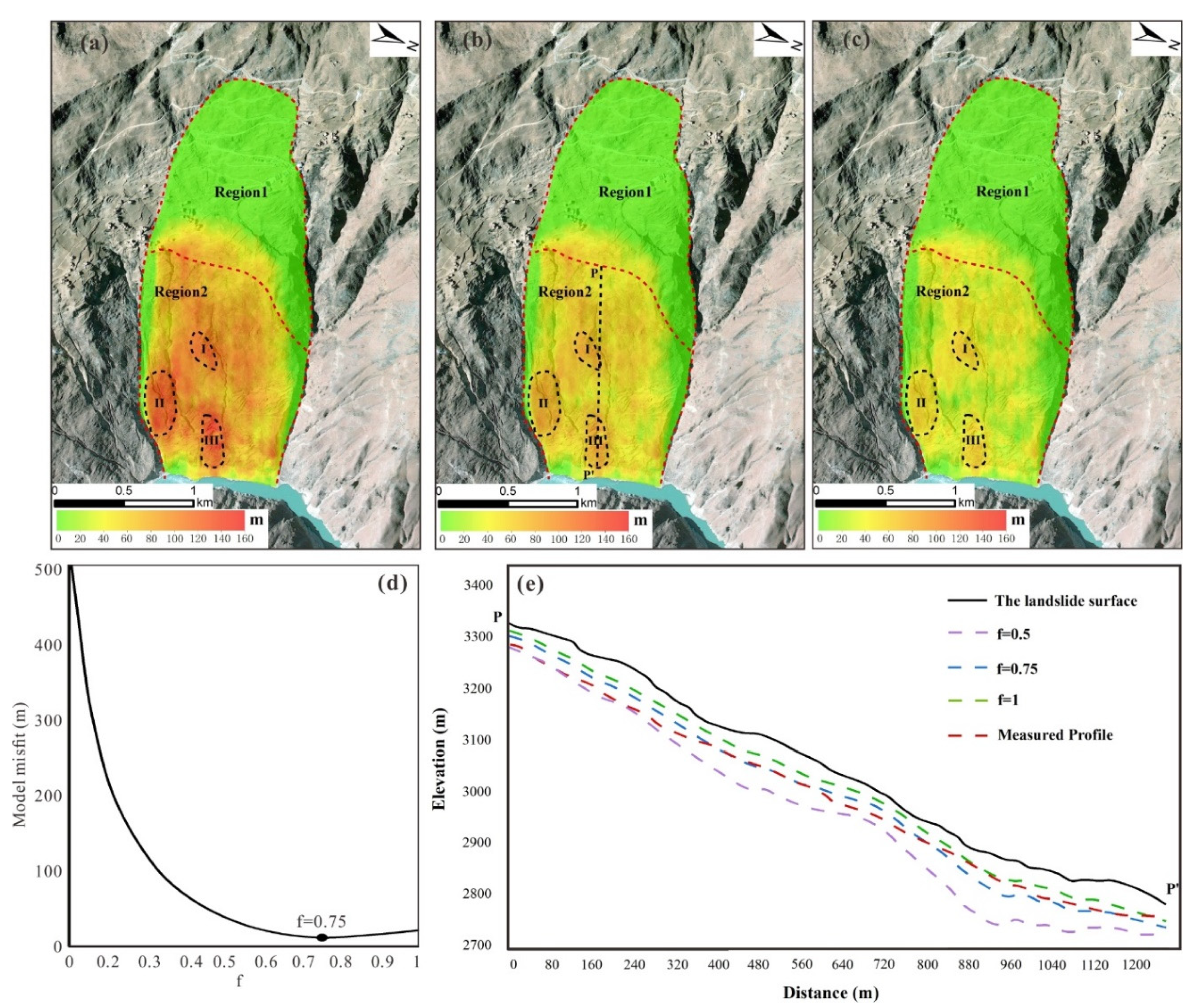
It can be seen from Equation (7) that the rheological parameter is crucial for estimating landslide thickness. This parameter can be assumed to be spatially uniform, with its value depending on the landslide rheology, ranging from 0 to 1 (Delbridge et al., 2016). To determine the best-fitting rheological parameter of the Xiongba-H2 landslide, a comparison was made between the landslide thickness measured through geophysical surveys and drilling data, and the thickness estimated through geodetic data inversion. First, we collected the geophysical exploration and drilling data of the Xiongba-H2 landslide. Then, the landslide thickness along the geological profiles I-I’ was extracted from the geophysical surveys and drilling data (Figure 1c). The optimal rheological parameter was determined from a testing of the experimental values of the rheological parameter varying from 0 to1 with a step of 0.01. For each given f, the landslide thickness along the profile I-I’ was estimated using Equation (7). The model misfit between the estimated and measured landslide thickness was derived. Figure 3d shows the model misfit versus f, and the best-fitting rheological parameter of 0.75 is selected when the model misfit reaches its minimum.
4. Results and Discussions
4.1. Two-Dimensional Deformation Fields of the Xiongba-H2 Landslide and Field Investigation
As described in Section 3.1, the two-dimensional deformation fields can be derived using the observed InSAR LOS deformation rates of the Xiongba-H2 landslide (Figure 2a,b), with the results shown in Figure 2c,d. It can be easily seen that significant deformation is mainly concentrated in the Region 2. The deformation rates along the slope direction range from 10.7 mm/yr to 195.1 mm/yr, while those in the normal direction range from -47.9 mm/yr to 60.5 mm/yr. Focusing on Figure 2c, significant deformation with a magnitude greater than 70 mm/yr is mainly concentrated in the area marked by ‘A’, located in the middle of the Region 2. However, the deformation in normal direction is mainly concentrated at the front edge (marked by ‘B’, Figure 2d) of the Xiongba-H2 landslide. The observed positive normal deformation within the ‘B’ area suggests a significant surface uplift motion. Furthermore, considering that the surface deformation rates along the slope direction are relatively low in the ‘B’ area, thus the surface uplift at the front edge of Xiongba-H2 landslide could probably be resulted from the pushing of the rock-soil mass in the ‘A’ area.
In addition, the field investigation indicates that a transverse tensile crack is found in the upper ‘A’ area, trending NE 2°, with a length of approximately 350 m and widths of 10-50 cm, as shown in Figure S3f. And the Unmanned Aerial Vehicle (UAV) optical images show that multiple longitudinal cracks (marked by the red solid lines in Figure S3) are present on the slope surface, with lengths ranging from 100 to 500 m. Since displacements in both the slope and normal directions are not significant in the C area (Figure 2), these surface fractures could result from the forward movement of the rock-soil mass in the A area.
4.2. Estimated Thickness of the Xiongba-H2 Landslide
The distributions of the landslide thickness were estimated using different rheological parameters of 0.5, 0.75 and 1.0 for comparison, as shown in Figure 3a–c. It can be found that the three results obtained from different rheological parameters show a similar spatial distribution pattern. However, the estimated landslide thickness gradually decreases as the value of the rheological parameter increases. Meanwhile, three regions (I, II, and III) with relatively greater thickness were identified from the results. Notably, these regions are characterized by abnormally elevated local topography (Figure S3), which is likely due to the accumulation of rock-soil mass from past landslide events. In addition, Region III is thicker than other parts of the landslide’s front edge along the Jinsha River, indicating an ample sediment source for the potential generation of landslide hazard. Furthermore, the front edge of the Xiongba-H2 landslide is characterized by steep topography, sparse vegetation cover, and abundant water resources, all of which suggest that Region III has a high potential for future failure.
Figure 3e shows the comparison between the estimated landslide thickness by geodetic inversion and the measured thickness by geophysical surveys and drilling data, along the profile P-P’. It could be found from Figure 3e that the estimated thickness distribution along the P-P’ profile differs for each rheological parameter, however the overall trend in thickness change remains consistent across the results. The estimated thickness reaches its maximum at the gently sloping platform located at the front edge of the Xiongba-H2 landslide, approximately 950 m from the starting point P. It can be easily seen that the estimated thickness profile with the rheological parameter of 0.75 has a better consistency with the measured thickness. And Figure 3d also indicates that the optimal rheological parameter is 0.75, where the misfit reaches its minimum. The average absolute difference is calculated to be less than 10 m, which is negligible compared to the average thickness of ~90 m along the profile P-P’. Such insignificant difference suggests the reliability of the proposed method of estimating the landslide thickness based on InSAR-derived 2D deformation. Above-mentioned difference between the estimated and measured thickness should result from a joint contribution of uncertainties in InSAR deformation caused by atmospheric delay and phase unwrapping errors, as well as the neglect of deformation along the direction perpendicular to the slope. The results estimated with the best-fitting rheological parameter of 0.75 (Figure 3b) show that the derived thickness of the Xiongba-H2 landslide is ranging from 10 to 100 m, corresponding to the active volume of 6.17×10⁷ m3.
5. Conclusions
In this study, a practical method of detecting the landslide thickness based on the 2D deformation derived from two-track InSAR observations is developed and applied to estimate the thickness of the Xiongba-H2 landslide. The proposed method originates from the principle of mass conservation. Considering the challenges of simultaneously acquiring InSAR observations from three or more orbital tracks, our proposed method is more feasible, as landslide thickness estimation relies solely on two-track InSAR observations. The comparison between the landslide thickness estimated by inverting the InSAR-derived 2D deformation and the measured thickness by geological and drilling methods verifies the reliability of our proposed method.
The result shows that two regions with different deformation patterns, including a frontal zone with significant deformation and a relatively stable zone, are identified in the InSAR LOS deformation rate fields. The decomposed 2D deformation indicates that the surface uplift motion at the front edge of Xiongba-H2 landslide could probably be resulted from the pushing of the rock-soil mass in the area with the most significant deformation along the slope direction. The inversion result suggests that the thickness of the Xiongba-H2 landslide is ranging from 10 to 100 m, corresponding to the active volume of 6.17×10⁷ m3. Addition, it suggests that a thicker region at the front edge along the Jinsha River, characterized by steep topography, sparse vegetation cover, and abundant water resources, poses the potential of further failure. The presented approach, which is low-cost and easy to implement, is expected to enhances the availability of InSAR technology for landslide motion analysis and hazard assessment.
Supplementary Materials
The following supporting information can be downloaded at the website of this paper posted on Preprints.org.
Data Availability Statement
The Sentinel-1 SAR images were provided by the ESA (European Space Agency). The SRTM-DEM data are available from https://e4ftl01.cr.usgs.gov/MEASURES/SRTMGL1.003/2000.02.11/SRTMGL1_page_2.html, accessed on 30 September 2024. The GACOS data is freely available here: www.gacos.net, accessed on 2 October 2024. The produced data including the ascending and descending orbital tracks InSAR deformation, the inferred two-dimensional deformation, and the estimated landslide thickness could be acquired on repository: https://doi.org/10.5281/zenodo.7291989.
Acknowledgments
This research is supported by the Fund for Creative Research Groups of China (41521002), State Key Laboratory of Geohazard Prevention and Geoenvironment Protection Independent Research Project (SKLGP2021Z016), Ministry of Science and Technology in Taiwan (110-2811-M-002-647 and 111-2811-M-002-116), and the Science and technology project of POWERCHINA (DJ-ZDXM-2020-03). And all the figures are mapped based on the Generic Mapping Tools (GMT) software (Wessel and Smith, 1998).
Conflicts of Interest
The authors declare no conflict of interest.
References
- Aryal, A.; Brooks, B.A.; Reid, M.E. Landslide subsurface slip geometry inferred from 3-D surface displacement fields. Geophysical Research Letters 2015, 42, 1411–1417. [Google Scholar] [CrossRef]
- Berardino, P.; Fornaro, G.; Lanari, R.; Sansosti, E. A new algorithm for surface deformation monitoring based on small baseline differential SAR interferograms. IEEE Transactions on geoscience and remote sensing 2002, 40, 2375–2383. [Google Scholar] [CrossRef]
- Bishop, K.M. Determination of translational landslide slip surface depth using balanced cross sections. Environmental & Engineering Geoscience 1999, 147–156. [Google Scholar] [CrossRef]
- Booth, A.M.; Lamb, M.P.; Avouac, J.P.; Delacourt, C. Landslide velocity, thickness, and rheology from remote sensing: La Clapière landslide, France. Geophysical Research Letters 2013, 40, 4299–4304. [Google Scholar] [CrossRef]
- Booth, A.M.; Roering, J.J.; Rempel, A.W. Topographic signatures and a general transport law for deep-seated landslides in a landscape evolution model. Journal of Geophysical Research: Earth Surface 2013, 118, 603–624. [Google Scholar] [CrossRef]
- Chen, J.; Chen, L. Geological analysis on characteristics and stability of Buwaqiao 2 deformation body in Wenchuan County. Science Technology and Enterprise 2011, 129–132. (in Chinese). [Google Scholar] [CrossRef]
- Costantini, M.; Rosen, P.A. A generalized phase unwrapping approach for sparse data. IEEE 1999 International Geoscience and Remote Sensing Symposium. IGARSS’99 (Cat. No. 99CH36293); IEEE, 1999; Vol. 1, pp. 267–269. [Google Scholar] [CrossRef]
- Delbridge, B.G.; Bürgmann, R.; Fielding, E.; Hensley, S.; Schulz, W.H. Three-dimensional surface deformation derived from airborne interferometric UAVSAR: Application to the Slumgullion Landslide. Journal of Geophysical Research: Solid Earth 2016, 121, 3951–3977. [Google Scholar] [CrossRef]
- Farinotti, D.; Huss, M.; Bauder, A.; Funk, M.; Truffer, M. A method to estimate the ice volume and ice-thickness distribution of alpine glaciers. Journal of Glaciology 2009, 55, 422–430. [Google Scholar] [CrossRef]
- Feigl, K.L.; Dupré, E. RNGCHN: a program to calculate displacement components from dislocations in an elastic half-space with applications for modeling geodetic measurements of crustal deformation. Computers & Geosciences 1999, 25, 695–704. [Google Scholar] [CrossRef]
- Guzzetti, F.; Ardizzone, F.; Cardinali, M.; Rossi, M.; Valigi, D. Landslide volumes and landslide mobilization rates in Umbria, central Italy. Earth and Planetary Science Letters 2009, 279, 222–229. [Google Scholar] [CrossRef]
- Handwerger, A.L.; Booth, A.M.; Huang, M.H.; Fielding, E.J. Inferring the Subsurface Geometry and Strength of Slow-Moving Landslides Using 3-D Velocity Measurements From the NASA/JPL UAVSAR. Journal of Geophysical Research: Earth Surface 2021, 126, e2020JF005898. [Google Scholar] [CrossRef]
- Huang, R.; Li, W. Post-earthquake landsliding and long-term impacts in the Wenchuan earthquake area, China. Engineering Geology 2014, 182, 111–120. [Google Scholar] [CrossRef]
- Hu, X.; Wang, T.; Pierson, T.C.; Lu, Z.; Kim, J.; Cecere, T.H. Detecting seasonal landslide movement within the Cascade landslide complex (Washington) using time-series SAR imagery. Remote Sensing of Environment 2016, 187, 49–61. [Google Scholar] [CrossRef]
- Hu, X.; Lu, Z.; Pierson, T.C.; Kramer, R.; George, D.L. Combining InSAR and GPS to determine transient movement and thickness of a seasonally active low-gradient translational landslide. Geophysical Research Letters 2018, 45, 1453–1462. [Google Scholar] [CrossRef]
- Jin, J.J. Study on development characteristics and stability of Xiongba giant paleolandslide in Jinshajiang Fault zone. Chinese Academy of Geological Sciences 2021. (in Chinese). [Google Scholar] [CrossRef]
- Li, X.; Guo, C.B.; Yang, Z.H.; Liao, W.; Wu, R.A.; Jin, J.J.; He, Y.X. Development characteristics and formation mechanism of xiongba giant paleolandslide in jinshajiang fault zone. Geoscience 2021, 35, 47–55. (in Chinese). [Google Scholar] [CrossRef]
- Meng, Q.; Xu, Q.; Wang, B.; et al. Monitoring the regional deformation of loess landslides on the Heifangtai terrace using the Sentinel-1 time series interferometry technique. Natural Hazards 2019, 98, 485–505. [Google Scholar] [CrossRef]
- Meng, Xm.; Qi, Tj.; Zhao, Y.; et al. Deformation of the Zhangjiazhuang high-speed railway tunnel: an analysis of causal mechanisms using geomorphological surveys and D-InSAR monitoring. Journal of Mountain Sicience 2021, 18, 1920–1936. [Google Scholar] [CrossRef]
- Mainsant, G.; Larose, E.; Brönnimann, C.; Jongmans, D.; Michoud, C.; Jaboyedoff, M. Ambient seismic noise monitoring of a clay landslide: Toward failure prediction. Journal of Geophysical Research: Earth Surface 2012, 117. [Google Scholar] [CrossRef]
- Mora, P.; Baldi, P.; Casula, G.; Fabris, M.; Ghirott, M.; Mazzini, E.; Pesci, A. Global Positioning Systems and digital photogrammetry for the monitoring of mass movements: application to the Ca’di Malta landslide (northern Apennines, Italy). Engineering Geology 2003, 68, 103–121. [Google Scholar] [CrossRef]
- Morlighem, M.; Rignot, E.; Seroussi, H.; Larour, E.; Ben, D.H.; Aubry, D. A mass conservation approach for mapping glacier ice thickness. Geophysical Research Letters 2011, 38. [Google Scholar] [CrossRef]
- Nadim, F.; Kjekstad, O.; Peduzzi, P.; Herold, C.; Jaedicke, C. Global landslide and avalanche hotspots. Landslides 2006, 3, 159–173. [Google Scholar] [CrossRef]
- Nguyen, H.N.; Vernant, P.; Mazzotti, S.; Khazaradze, G.; Asensio, E. 3-D GPS velocity field and its implications on the present-day post-orogenic deformation of the Western Alps and Pyrenees. Solid Earth 2016, 7, 1349–1363. [Google Scholar] [CrossRef]
- Nikolaeva, E.; Walter, T.R.; Shirzaei, M.; Zschau, J. Landslide observation and volume estimation in central Georgia based on L-band InSAR. Natural Hazards and Earth System Sciences 2014, 14, 675–688. [Google Scholar] [CrossRef]
- Pepe, A.; Euillades, L.D.; Manunta, M.; Lanari, R. New advances of the extended minimum cost flow phase unwrapping algorithm for SBAS-DInSAR analysis at full spatial resolution. IEEE Transactions on Geoscience and Remote Sensing 2011, 49, 4062–4079. [Google Scholar] [CrossRef]
- Petley, D. Global patterns of loss of life from landslides. Geology 2012, 40, 927–930. [Google Scholar] [CrossRef]
- Raucoules, D.; Michele, M.D.; Malet, J.P.; Ulrich, P. Time-variable 3D ground displacements from high-resolution Synthetic Aperture Radar (SAR). application to la valette landslide (South French Alps). Remote Sensing of Environment 2013, 139, 198–204. [Google Scholar] [CrossRef]
- Rowan, M.G.; Kligfield, R. Cross section restoration and balancing as aid to seismic interpretation in extensional terranes. AAPG Bulletin 1989, 73, 955–966. [Google Scholar] [CrossRef]
- Simeoni, L.; Mongiovì, L. Inclinometer monitoring of the Castelrotto landslide in Italy. Journal of Geotechnical and Geoenvironmental Engineering 2007, 133, 653–666. [Google Scholar] [CrossRef]
- Stark, T.D.; Choi, H. Slope inclinometers for landslides. Landslides 2008, 5, 339–350. [Google Scholar] [CrossRef]
- Wang, X.; Fan, X.; Yang, F.; Dong, X. Remote Sensing Interpretation Method of Geological Hazards in Lush Mountainous Area. Geomatics and Information Science of Wuhan University 2020, 45, 1771–1781. (in Chinese). [Google Scholar] [CrossRef]
- Yan, Y.Q.; Guo, C.B.; Zhang, Y.S.; Zhang, X.J.; Zheng, Y.Z.; Li, X.; Yang, Z.H.; Wu, R.A. Deformation characteristics of Xiongbaogu Landslide in Xizang Province based on SBAS-insAR technology. Acta geologica sinica 2021, 95, 3556–3570. (in Chinese). [Google Scholar] [CrossRef]
- Yang, C.; Yang, Y.H.; Wang, J.Y.; et al. Inferring the landslide depth based on ascending and descending InSAR deformations-Example of the Taoping village ancient landslide. Journal of Engineering Geology 2021. (in Chinese), Online. [Google Scholar]
- Yin, Y.; Wang, F.; Sun, P. Landslide hazards triggered by the 2008 Wenchuan earthquake, Sichuan, China. Landslides 2009, 6, 139–152. [Google Scholar] [CrossRef]
- Zhang, T.; Fang, X.; Song, C.; Appel, E.; Wang, Y. Cenozoic tectonic deformation and uplift of the South Tian Shan: implications from magnetostratigraphy and balanced cross-section restoration of the Kuqa depression. Tectonophysics 2014, 628, 172–187. [Google Scholar] [CrossRef]
Figure 1.
Geologic background of the study area. (a) Coverage of the used SAR images (Black rectangles) and the location of the Xiongba ancient landslide (Red star). (b) Optical images covering the Xiongba landslide. The black solid line indicates the spatial range of the Xiongba ancient landslide, and the red dashed lines represent two secondary landslides (H1 and H2) of the Xiongba ancient landslide. (c) Geological profile along the line II’ marked in (b) (Jin et al., 2021).
Figure 1.
Geologic background of the study area. (a) Coverage of the used SAR images (Black rectangles) and the location of the Xiongba ancient landslide (Red star). (b) Optical images covering the Xiongba landslide. The black solid line indicates the spatial range of the Xiongba ancient landslide, and the red dashed lines represent two secondary landslides (H1 and H2) of the Xiongba ancient landslide. (c) Geological profile along the line II’ marked in (b) (Jin et al., 2021).
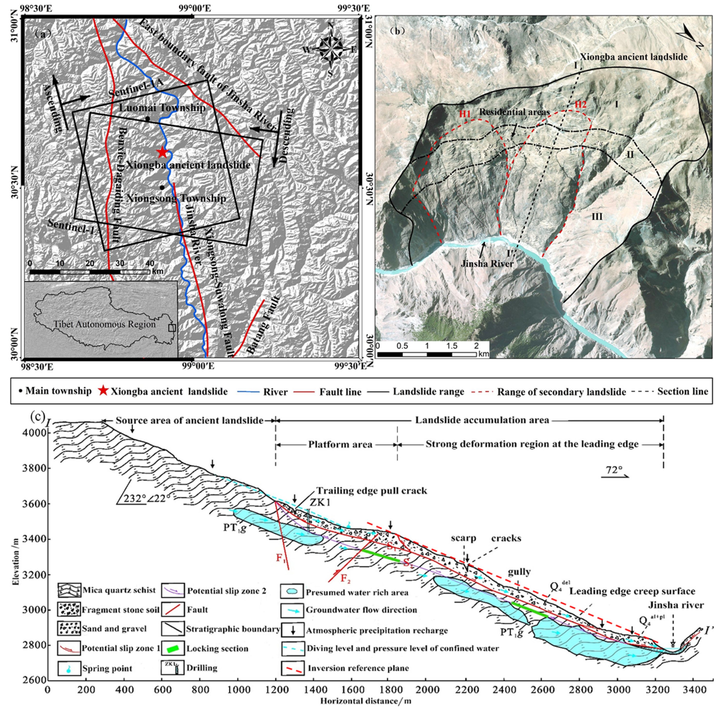
Figure 2.
Ground deformation rates of the Xiongba-H2 landslide derived from the ascending (a) and descending (b) InSAR tracks, and the estimated two-dimensional velocity components along the slope (c) and normal (d) directions. The red dashed lines show the spatial scope of the Xiongba-H2 landslide and the boundary between the deformed zone (Region2) and stable zone (Region1). The black dashed lines denote the areas with significant deformation rates. The time-series deformation rates of the chosen points marked by T1 and T2 are shown in Figure S1. OK, OT, OI axes indicate the landslide motion coordinate system (Details can be found in Figure S2), and red axis shows the corresponding directions of the deformation components in Figure 2c,d.
Figure 2.
Ground deformation rates of the Xiongba-H2 landslide derived from the ascending (a) and descending (b) InSAR tracks, and the estimated two-dimensional velocity components along the slope (c) and normal (d) directions. The red dashed lines show the spatial scope of the Xiongba-H2 landslide and the boundary between the deformed zone (Region2) and stable zone (Region1). The black dashed lines denote the areas with significant deformation rates. The time-series deformation rates of the chosen points marked by T1 and T2 are shown in Figure S1. OK, OT, OI axes indicate the landslide motion coordinate system (Details can be found in Figure S2), and red axis shows the corresponding directions of the deformation components in Figure 2c,d.
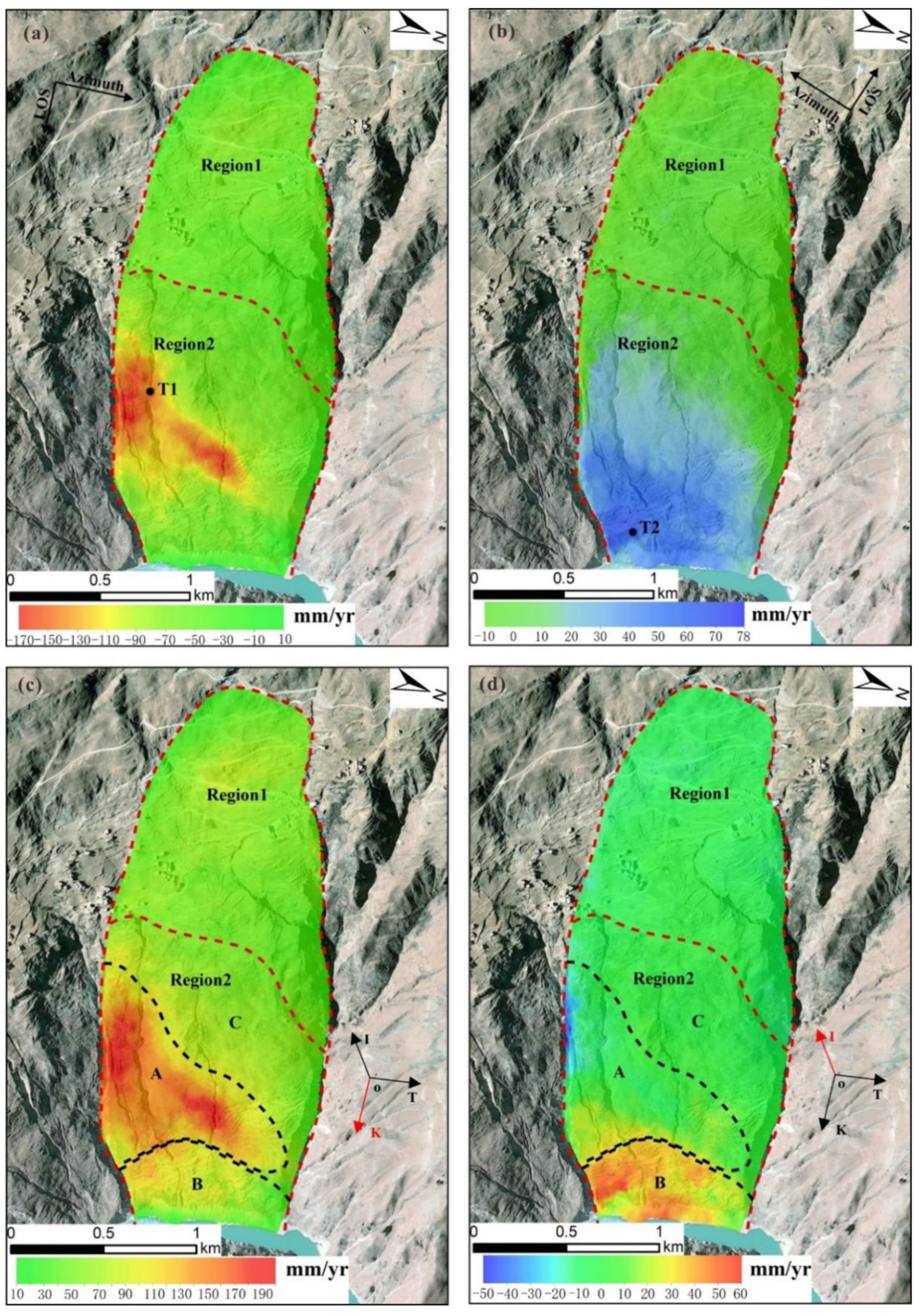
Figure 3.
Distribution of the estimated thickness of the Xiongba-H2 landslide with different rheological parameters of 0.5 (a), 0.75 (b) and 1.0 (c), respectively. Regions I, II and III marked by black dashed lines indicate zones with relatively greater thickness. P-P’ shows the surface trace of the geological profile, which is a segment of the profile I-I’ shown in Figure 1c. (d) Model misfit versus the rheological parameter f, and the misfit reaches its minimum when the rheological parameter equals 0.75. (d) Detailed distributions of landslide thickness along the P-P’ profile. The black solid line indicates the ground surface of the Xiongba-H2landslide. The purple, blue, and green dashed lines represent the estimated thickness profiles with rheological parameters of 0.5, 0.75, and 1, respectively. The red dashed line denotes the measured thickness based on drilling and geophysical methods (Jin, 2021).
Figure 3.
Distribution of the estimated thickness of the Xiongba-H2 landslide with different rheological parameters of 0.5 (a), 0.75 (b) and 1.0 (c), respectively. Regions I, II and III marked by black dashed lines indicate zones with relatively greater thickness. P-P’ shows the surface trace of the geological profile, which is a segment of the profile I-I’ shown in Figure 1c. (d) Model misfit versus the rheological parameter f, and the misfit reaches its minimum when the rheological parameter equals 0.75. (d) Detailed distributions of landslide thickness along the P-P’ profile. The black solid line indicates the ground surface of the Xiongba-H2landslide. The purple, blue, and green dashed lines represent the estimated thickness profiles with rheological parameters of 0.5, 0.75, and 1, respectively. The red dashed line denotes the measured thickness based on drilling and geophysical methods (Jin, 2021).
Disclaimer/Publisher’s Note: The statements, opinions and data contained in all publications are solely those of the individual author(s) and contributor(s) and not of MDPI and/or the editor(s). MDPI and/or the editor(s) disclaim responsibility for any injury to people or property resulting from any ideas, methods, instructions or products referred to in the content. |
© 2024 by the authors. Licensee MDPI, Basel, Switzerland. This article is an open access article distributed under the terms and conditions of the Creative Commons Attribution (CC BY) license (http://creativecommons.org/licenses/by/4.0/).
Copyright: This open access article is published under a Creative Commons CC BY 4.0 license, which permit the free download, distribution, and reuse, provided that the author and preprint are cited in any reuse.


