Submitted:
08 October 2024
Posted:
09 October 2024
You are already at the latest version
Abstract
Estuaries and deltas possess significant socioeconomic importance and exhibit high ecological value because of their dynamic geomorphic processes and unique geographical advantages. However, delta recession and the instability of river regimes have become worldwide issues due to intensive human interventions in upstream river basins and local areas in recent decades. This study focuses on a typical example, the South Branch of the Changjiang Estuary, to explore its morphological evolution in the past decades and near future and propose suitable solutions to enhance the stability of the river regimes. Based on bathymetric data analysis, we find significant channel-shoal adjustment within the South Branch from 1958 to 2016, characterized by substantial erosion and deposition on decadal timescales. After 1997, the South Branch experienced overall erosion due to the reduced fluvial sediment supply. Disturbances on the Baimao Shoal and Biandan Shoal further aggravated the river regime’s stability. Numerical predictions for future evolution trends indicate continuous erosion in the South Branch over the next 20 years, with further adjustments to the channel-shoal pattern. Hydrodynamic modeling of the proposed measures demonstrates an increased ratio for the North Baimao Shoal Channel, leading to enhanced stability of the channel-shoal system. These integrated governance measures have been incorporated in the new round of renovation planning for the Changjiang Estuary. The findings provide valuable scientific guidance for the comprehensive management of the Changjiang Estuary and offer insights applicable to other large estuaries.
Keywords:
Changjiang Estuary
; decadal morphological evolution
; governance measures
; South Branch
; numerical simulation
1. Introduction
The estuary is a transitional zone that connects rivers and oceans. Terrestrial-derived sediment is deposited and transported in the estuary, which shapes its complex and diverse environment and geomorphic form [1]. As one of the most active zones in the land–sea interaction interface, estuaries and deltas can provide abundant natural resources, including land, freshwater, fossil energy, agriculture, navigation, and ecological services. Therefore, many of the world’s large estuaries and deltas are densely populated and economically developed [2]. Their unique geographical benefits confer important socioeconomic and ecological significance on estuaries [3]. However, global climate change and human activities have exerted unprecedented changes and challenges to the morphological evolution and utilization of estuaries. Many estuaries and deltas around the world are undergoing a transition from accretion to erosion, such as the Nile, Mississippi, and Mekong, which has been mainly caused by river sediment reduction [2]. The three largest estuaries in China—the Yellow, Changjiang, and Pearl—are all facing the problem of erosion to varying degrees, rendering them high-risk areas [4]. Understanding the morphological processes and future trends at the decadal timescale, and proposing sustainable solutions have become primary concerns for both academic community and governments.
The morphodynamics of estuaries are primarily controlled by the interactions of river flow, tidal forcing, and waves [5]. However, natural evolutionary processes have been interrupted by river input changes, and local human interventions have further complicated the estuarine response [6,7,8]. The morphological response to fluvial sediment declines and local human interventions, and the stability of the estuarine regime, have been widely explored through data-driven analysis and process-based modeling. The former method improved our understanding of the features and causes of morphological changes based on the topographic and bathymetric dataset. This approach has been successfully applied in numerous cases studies [6,8,9,10,11,12,13]. The latter method elucidates the intrinsic mechanism between physical forcing and morphological responses, enabling the prediction of future trends in estuarine morphological evolution mbox [14,15]. The morphology accelerating technique allows to predict medium- and long-term evolution trends using the morphology accelerating technique [16]. The combination of these two methods is useful for exploring the underlying evolutionary mechanisms, forecasting future trends, and formulating effective governance measures.
The large-scale and three-level bifurcated Changjiang Estuary is the mouth of the largest and longest river in Asia (Figure 1). It has been heavily influenced by human activities, which have altered river discharge and sediment load in the catchment since the 1980s and have resulted in major engineering projects within the estuary since the late 1990s. Over time, due to reduced sediment supply, the Changjiang Estuary has converted from a state of net accretion to net erosion from the inner estuary to the mouth bar area and subaqueous delta front [6,17,18]. The construction of estuarine engineering projects has also played an important role in local morphological changes, although variable features were identified in different bifurcation channels and shoals [8,19,20,21,22]. As the first bifurcation of the Changjiang Estuary, the South Branch is the main conduit for discharge, being responsible for more than 95% of the freshwater runoff to the sea. Plenty of harbors, infrastructure, and freshwater reservoirs are located around the South Branch, and it is currently the only 12.5-m-deep navigation channel connecting the Changjiang Golden Waterway to overseas shipping. Therefore, the river regime stability of the South Branch is very important for regional economic development. Previous studies have examined the recent morphological processes of the South Branch and analyzed relevant controlling factors [23,24,25]. The riverbed has experienced continuous erosion since the closure of the Three Gorges Dam in 2003, and the river regime has shown self-adaption processes under changing conditions [26]. The flow diversion pattern of the Baimao Shoal is changing, and the Biandan Shoal is the largest uncontrolled shallow shoal in the inner Changjiang Estuary. These factors may cause instability of the river regime, and systematic research on governance measures is urgently needed, which is the main motivation of the present study.
The aims of this paper are to (1) explore the stability of the river regime in the South Branch based on historical bathymetry dataset and numerical predictions; and (2) propose and evaluate the governance measures to stabilize the river regime. These research findings can not only guide the comprehensive control of the Changjiang Estuary but also support high-quality regional social and economic development. The rest of this article is arranged as follows. The introduction of study area are given in Section 2. In Section 3, data and methods are described. Section 4 presents and discusses the numerical results. Finally, the paper contains some conclusions in Section 5.
2. Study Area
Abundant river runoff and sediment load, forced by river flow, astronomic tides, and wind waves, enter the Changjiang Estuary, which forms a landform pattern with a three-level bifurcation and four-outlet configuration [27]. The estuary spans from Xuliujing to the outer subaqueous delta, with a length of more than 180 km. The channel width has increased from approximately 5 km at the inner estuary to more than 90 km at the mouth bar area (Figure 1(b)). Multiple channel-shoal systems can be found within the estuary, ranging from several kilometers to dozens of kilometers. River runoff has remained relatively stable, except for several wet or dry years since the 1950s. Because of the river damming and conservation of water and soil in the basin, the sediment load started to decrease in the 1980s and dropped to a low level (134 Mt/a) after the closure of the Three Gorges Dam in 2003 (Figure 2). The mean and maximum tidal range values in the Changjiang Estuary are 2.66 m and 4.62 m, respectively [28]). Under the combined effects of high river flow and medium tidal current, the Changjiang Estuary can be classified as a joint river- and tide-controlled estuary.
The South Branch is the first-level bifurcation from Xuliujing to Wusong, with a length and width of approximately 70.5 km and 5.7–15 km, respectively. The main channel is divided into two secondary channels by the Baimao Shoal. The head of the shoal was fixed by engineering work in 2014 for navigation purposes. The Biandan Shoal spans from the south bank of Chongming Island to the end of the South Branch, forming a large-scale channel-shoal system along with the flood-dominated Xinqiao Channel and the ebb-dominated main channel. River regulation projects, including the Qingcaosha Reservoir, the Xinliuhe Shoal protection works, and the submerged breakwater at the Nanshatou Channel, which were completed in 2009, have fixed the bifurcation site of the North and South Channels. Apart from the Biandan Shoal, the overall channel-shoal pattern within the South Branch has remained relatively stable since the completion of these regulation projects.
3. Data and Methods
3.1. Bathymetric Data
To quantify decadal morphological changes, we collected bathymetry data covering the South Branch observed in multiple years (1958, 1978, 1986, 1997, 2007, and 2016). The bathymetry data observed in 1958, 1978, and 1986 are digitized from the marine charts published by the Navigation Guarantee Department of the Chinese Navy Headquarters, and the rest are gratefully provided by the Yangtze Estuary Waterway Administration Bureau of Ministry of Transport. Most of these measurements were taken after river flooding. The water depth and positions were measured using an echo sounder and the global positioning system, respectively. The scales of bathymetry maps varied from 1:25,000 to 1:50,000. The density of depth points was acceptable for calculating erosion and accretion volumes [13]. Using the geographic information system (GIS) software, we produced a digital elevation model (DEM) with 50 × 50 m grid resolution using the Kriging interpolation method. We obtained erosion and deposition patterns by subtracting a later DEM grid from an earlier one. The domain for calculating channel volume and erosion/accretion volume was defined as shown in Figure 1(b).
3.2. Numerical Modeling
3.2.1. Establishing and Validation of the Model
We jointly used the hydrodynamic module and mud transport module of the MIKE 21 flow model [29]. The hydrodynamic model is a depth-averaged two-dimensional model based on unstructured grids. The numerical simulation area (Figure 3) starts from Jiangyin (tidal current limit) to the East China Sea, which is approximately 200–240 km outside the mouth of the Changjiang River. Because of the large spatial scale of the model domain, different grid resolutions were adopted in different subareas. The roughness coefficient was given empirically and showed a decreasing trend from upstream to downstream. At the open-sea boundary of the model, we extracted the tidal level from the MIKE global tide model. We adjusted the phase and median value of the extracted tidal level to the local time zone and height datum. The sediment concentration at the open-sea boundary was set to zero. A zero-gradient condition for the open-sea boundary was also tested, and the results showed no difference in most areas. Water flow discharge and sediment concentration series were provided for the section at Jiangyin, which is the upstream boundary of the Changjiang River.
We used tidal levels and velocities at 14 stations during the flood season in August 2017 to validate the hydrodynamic parameters. We repeatedly simulated topographic change from November 2011 to October 2016 to determine the parameters used in the MT (Mud Transport) module. In simulating the morphological evolution process from 2011 to 2016, we averaged the series of water flow discharge and sediment concentration at Jiangyin twice to reduce computation costs. The first averaging was a multiyear averaging, which averaged the five-year process to one year. The second averaging was carried out after dividing a year into five periods, and each period contained five spring-neap tidal cycles. Each spring-neap tidal cycle includes a spring tide and a neap tide, with a total of approximately 14.6 days. The second averaging was the average of five spring-neap tide cycles in each period. Because of these two averaging processes, the acceleration factor for evolution computing was 25. The other settings and the validation of the model are available in our previous study [30].
3.2.2. Model Setting for Evolution Prediction
The initial bathymetry used for the evolution prediction of the Changjiang River Estuary was based on the topography data surveyed in October 2016. The data on water and sediment discharge at Jiangyin were provided by a one-dimensional water flow and sediment transport model, which covers the reach from Datong to Xuliujing in the lower Changjiang River. We used the inflow process of water flow discharge and sediment concentration from 2008 to 2017 for the evolution prediction.
To ensure consistency with the validation process and reduce the computation cost, we applied this averaging process for the inflow condition from 2008 to 2017. The boundary conditions of water flow discharge and sediment concentration at Jiangyin in a computation period are shown in Figure 4. A computational period contained five intervals. Each interval lasted approximately 14.6 days (a spring-neap tidal cycle). Because the acceleration factor for evolution computing was 25, a computational period represented five years for bed evolution. The evolution prediction had four computational periods, covering a total span of 20 years.
3.2.3. Model Setting for Measure Comparison
To obtain a reasonable governance measure for stabilizing the river regime, we compared the effect of different measures using the validated model. Considering that the uncertainty in simulating bed evolution was much higher than that in simulating water flow movement, we carried out hydrodynamic simulations only for the measurement comparison. The period selected for comparison lasted for 24 hours, from September 23 at 0:00 am to September 24 at 0:00 am in 2002. During this period, the average inflow discharge from Changjiang River at Jiangyin was approximately 36000 m3/s, which was a medium flow discharge, and the outer sea was a spring tide.
To assess the effect of the governance measures on the tidal level and flow velocity, we arranged monitoring points in each waterway and on shallow shoals. All of these points are depicted in Figure 5 and Table 1. We also set up cross-sections in each channel and output the modeling results of the sectional flow discharge to calculate the diversion ratio. The location of each section is shown in Figure 5.
4. Results and Discussion
4.1. Observed Morphological Changes
The South Branch experienced remarkable channel-shoal adjustment from 1958 to 2016, and the evolution features showed significant temporal and spatial variations. The Baimao Shoal formed in the 1950s as fluvial sediment settled at the middle of the channel because of its sudden widening, and flow velocity decreased downstream of the Xuliujing node (Figure 6(a)). After the formation, the Biandan Shoal gradually became larger and higher, and reached its largest scale in its lifespan around 1997 (Fig. 6b–6d). Since then, the channel-shoal system has remained relatively stable and was further enhanced by the engineering works at the head of the Baimao Shoal in 2014. The ebb diversion ratio of the South Baimao Shoal Channel (the river channel on the south side of Baimao Shoal) increased from 57.2% in 2002 to 72.7% in 2012, whereas the North Baimao Shoal Channel (the river channel on the north side of Baimao Shoal) has been silted up and shrunk. The deposition in the North Baimao Shoal Channel was caused primarily by extreme flood events in the Changjiang River and sediment flow backward from the North Branch [31]. Downstream, the Baimao Shoal, the Biandan Shoal, the main channel (ebb-dominant), and the Xinqiao Channel (flood-dominant) constituted the large-scale compound channel-shoal system, which has been widely identified in the world’s many tidal rivers [32]. The Biandan Shoal formed over a century and is still under natural evolution. The Upper Biandan Shoal, which is attached to Chongming Island in a relatively fixed location, and the Lower Biandan Shoal showed downstream migration and squeezed the Xinqiao Connecting Channel. From the late 1970s to the mid-1980s, shoal incision and merging occurred at the end of the South Branch, which resulted in a significant adjustment of the channel-shoal pattern in a short period (Figure 6(b)-(c)). After the late 1980s, the Lower Biandan Shoal switched into a new evolution period [6]. After the training jetties were constructed at the head of the Xinliuhe Shoal in 2009, the ebb diversion through the Xinqiao Connecting Channel weakened, which led to the incision of the Biandan Shoal (Figure 7(e)-(f)).
Erosion and deposition within the South Branch are significant from 1958 to 2016. From 1958 to 1978, deposition occurred mainly at the Baimao Shoal and the Lower Biandan Shoal due to shoal growth and downstream migration, respectively (Figure 7(a)). From 1978 to 1986, the position of erosion and accretion near the end of the Biandan Shoal was reversed relative to the previous period (Figure 7(b)). This reverse resulted from the incision of the Biandan Shoal and the emergence of the separated shoal into the downstream shoals. After 1986, erosion was found in most areas of the South Branch, especially from 1986 to 1997 (Figure 7(c)). Our previous study revealed that the primary contributors were fluvial sediment decline in the 1980s and frequent river floods during the 1990s [6]. After 1997, the erosion and deposition patterns continued with similar features, although overall erosion dominated the South Branch from 2007 to 2016 (Figure 7(d)-(e)). As shown by the hypsometry curves of the South Branch, the inflection point was between −10 m and −15 m, which separated the shoals and the main channel. The shoals shifted from overall accretion to erosion after the late 1970s, whereas the main channel showed continuous erosion (Figure 8). Therefore, the South Branch became narrower and deeper. In addition to decreasing sediment supply, levee and harbor construction along the banks also played an important role in this change.
4.2. Instability of the River Regime
The river regime of the South Branch was controlled by both river-tidal interaction and local engineering projects. Although the Baimao Shoal experienced division and merging in the 1980s, the double-bifurcation pattern has remained stable in recent decades. To stabilize the location of the talweg line near Xuliujing, the artificial node was created through protecting riverbanks that are prone to scour. After the establishment of the artificial node at Xuliujing, the oscillation range of the mainstream line was mitigated. Moreover, the southward mainstream was deepened and narrowed due to the riverbed scouring compensating for the reduced fluvial sediment discharges [25], which led to the rapid development of the South Baimao Shoal Channel. Subsequently, the slope of the south bank became steeper, which threatened the safety of Taicang Port and the embankment [33]. Since the development of the South Baimao Shoal Channel has been conducive to the inflow of the North Channel rather than the South Channel. This current evolution trend may cause river regime instability in the lower part of the South Branch and threaten the deep navigation channel along the South Channel and North Passage.
Regarding the Biandan Shoal system, the mainstream of the Xinqiao Connecting Channel migrated downstream and grew narrower during the migration of the Lower Biandan Shoal. This resulted in erosion near the upstream side of the Qingcaosha Reservoir and threatened the safety of the reservoir embankment. Moreover, the narrowing in the Xinqiao Connecting Channel weakens the diversion capacity and indirectly enhances the ebb flow near the Biandan Shoal upstream. The enhanced ebb flow passing the Biandan Shoal leads to further channel scouring, particularly during river flood. Because of the increased water level gradient at its north and south side. The incision of the Biandan Shoal also may have caused erosion along the Xinqiao Channel. These changes have deteriorated the stability of the river regime of the South Branch and thereby have increased the difficulty of the comprehensive utilization of the Changjiang Estuary.
4.3. Numerical Predictions for Future Evolution
The numerical predicted cumulative deposition/erosion thickness in the South Branch over the next 20 years is shown in Figure 9. In the central region of the bifurcation area between the South and North Branch, significant scouring is anticipated, with depths ranging from 2 to 10 m. Conversely, deposition of approximately 0 to 10 m is expected at the corner of the northern waterfront and the small shoal adjacent to the south bank. Additionally, the entrance to the North Branch will become more curved, leading to a further dominance of the rising tide in the North Branch.
The Baimao shoal is expected to undergo siltation, while its main neighboring troughs will experience scouring. Specifically, the South Baimao Shoal Channel will be flushed with a maximum scour thickness exceeding 10 m whereas the North Baimao Shoal Channel will simultaneously experience mild erosion and mild deposition. Therefore, the diversion ratio of the South Baimao Shoal Channel would increase, which will not be favorable for sustaining the diversion ratio of the South Channel.
The head of the Upper Biandan shoal will be silted up while its tail will be scoured, leading to a further separation from the Lower Biandan Shoal. On the south side of the Lower Biandan Shoal, the Xinqiao Connected Channel will be scoured. Additionally, sediment deposition will extend further at the tail of the Lower Biandan Shoal. Similar sediment deposition will also occur in the head area of the Xinliuhe Shoal, which connects with Changxing Island. The scoured zone located between the Upper and Lower Biandan Shoal, specifically between Gelong Port and Nanmen Port, is referred to as the Xingelonggang Channel. The development of this scoured zone has facilitated the growth of the Xinqiao Channel while posing a threat to the stability of the Lower Biandan Shoal. The head of the Lower Biandan Shoal is expected to undergo mild deposition, whereas the middle and lower sections of the shoal will suffer stronger deposition. The Xinqiao Channel on the north side of the Lower Biandan Shoal will be silted up, but the southern edge of the Lower Biandan Shoal will experience scouring, causingthe widening the Xinqiao Connecting Channel.
In general, the results indicate that the South Branch will experience net scouring, and the river regime will remain unchanged. However, without appropriate measures, significant scouring and expansion are expected in both the South Baimao Shoal Channel and the Xinqiao Connecting Channel. Simultaneously, the North Baimao Shoal Channel and the entrance to the South Channel may undergo a reduction in size. This evolution trend could reduce the water flow diversion ratio of the North Baimao Shoal Channel and the South Channel, which will not be conducive to maintaining a deep navigation channel in the South Channel. In addition, the Upper and Lower Biandan Shoals will be further separated, which will negatively be affecting the stability of the Lower Biandan Shoal.
4.4. Effect of Governance Measures
4.4.1. Baimao Shoal
To seek the best governance measure for the Baimao Shoal, we list four governance measures in Table 2 and Figure 10. All of the measures in Table 2 have been screened in an early stage. We have omitted the intermediate data and have described only the results.
Each of the four measures aimed to reduce the diversion ratio of the South Baimao Shoal Channel. Among them, option 2 showed the most significant effect, resulting in an increase of 20.84% in the diversion ratio of the ebb tide stream in the North Baimao Shoal Channel. In contrast, options 1, 3, and 4 increased the diversion ratio by only 0.2%, 1.19%, and 1.46%, respectively.
Furthermore, the governance measures have an impact on the tide levels, which is a crucial consideration for floodproofing and riverbank drainage. Option 2 leads to a general rise in the highest tide levels at the monitoring stations, with the maximum increase being approximately 0.059–0.068 m. In options 3 and 4, the highest tide levels at those points also increase, but the increments are less than 0.05 m. Under option 1, the increments of the highest tide level at the monitor points are all less than 0.01 m. According to these results, we believe that the option 2 causes high water level whereas option 1 results in too low water levels and therefore options 3 and 4 are recommended.
4.4.2. Biandan Shoal
The stability of the Biandan Shoal is pivotal for the stability of the river regime in the South Branch and the diversion between the South Channel and the North Channel. To stabilize the Biandan Shoal, a protective measure should be taken. In Table 3 and Figure 10, we provide three options, among which the only difference is the crest level of the submerged breakwater.
Under the influence of the measures, both flood tide and ebb tide volumes in the South Branch decreased, and the flood tide volume decreased more than the ebb tide volume. Options 2 and 3 had little effect on the diversion ratio of the North and South Baimao Shoal Channels, and option 1 decreased the diversion ratio of the ebb tide stream in the North Baimao Shoal Channel slightly. The diversion ratio between the South Channel and the North Channel changed more significantly than the ratio in the North and South Baimao Shoal Channels. Options 1, 2, and 3 increased the diversion ratio of the ebb tide stream in the South Channel by 1.31%, 1.27%, and 0.84%, respectively. As the Changjiang Estuary deep-water channel passes through the South Channel, a moderate increase in the diversion ratio of the South Channel would be favorable.
Considering the tidal level, the effect of option 1 was much stronger than the other two options. All of the measures had only a slight impact on the high tidal level, with the highest tidal level in most areas decreasing. However, the low tide level in the South Branch was more substantially affected. The lowest tidal levels at the monitoring points near the outlet of the Dangxi River and the Liu River increased by approximately 0.050–0.100 m, 0.024–0.088 m, and 0.024–0.090 m under options 1, 2, and 3, respectively. The rise in low tide level poses challenges for riverbank drainage.
Considering the overall impact of the measures, as well as the project size and eco-friendliness, option 3 is recommended for the governance of Biandan Shoal.
4.4.3. Combined Governance Measures
Governance measures are planned for both Baimao Shoal and Biandan Shoal. The joint effect of multiple projects may be different from the simple superposition of the effects of every single project. Therefore, we tested the effect of combined governance measures, which are listed in Table 4.
The simulation results showed that, in general, the combined measures align with the individual measures in terms of their effects. Under options 1, 2, and 4, the diversion ratios in the North Baimao Shoal Channel increased by approximately 0.4%, 0.5%, and 0.9%, respectively, for both the flood tide and ebb tide stream. However, option 3 resulted in a significantly larger increase of 4-4.5% in the diversion ratio in the North Baimao Shoal Channel which was much higher than the other three options. For the diversion ratios in the North Channel, however, option 3 exhibited a slightly weaker effect compared to the other three options. Under all four options, the diversion ratio of the ebb tide stream in the North Channel decreased whereas the ratio of the flood tide stream increased. The variations of the diversion ratios in the North Channel (as well as in the South Channel) under options 1, 2, and 4 were quite similar. They all led to a decrease of approximately 0.8% in the diversion ratio of the ebb tide stream and an increase of approximately 1.8% in the diversion ratio of the flood tide stream in the North Channel. In contrast, option 3 resulted in variations of 0.2% (decrease) and 0.8% (increase) for the ebb and flood tide, respectively.
Considering the high tide level of monitoring points, those points located in the South Branch were the most affected under all four options. Option 3 had the most significant effect, with the increment of the highest tide level exceeded 5 cm near the Nanmen Port. In contrast, the increments in the other three options did not exceed 3 cm (As an example, the variation of high tide level under option 4 was illustrated in Figure 11). The difference in the effect on the low tide level under different options was similar to that of the high tide level. Option 3 resulted in increments of the lowest tide levels for points along the South Baimao Shoal Channel that exceeded 10 cm, while the corresponding increments for the other three options did not exceed 7 cm.
4.4.4. Recommended Governance Measures
The purpose of the governance measures is to maintain the current bifurcation status, stabilize the Biandan Shoal, increase the diversion ratio of the North Baimao Shoal Channel, and control any potential increase in the diversion ratio of the ebb tide stream in the North Channel. According to a comparison of the governance measures for Baimao Shoal, these results indicated that all the measures aligned with the intended purpose. However, a larger variation in the diversion ratio in the South Baimao Shoal Channel would lead to a greater rise in high tidal levels, which could have unfavorable implications for flood control and riverbank drainage. As a result, the two measures with moderate effect are recommended for Baimao Shoal. For the Biandan Shaol, three different measures worked similarly—generally, the higher the crest elevation of the submerged breakwaters, the greater the change in the diversion ratio between the North and South Channels, and the larger the increment of the lowest tide level in the South Branch. Considering the cost and eco-friendliness of governance measures, the option with the lowest crest elevation of the submerged breakwater was recommended among the compared measures. The combined governance measures show effects consistent with the individual measures. Taking both the positive and negative impacts into account, the last option in Table 4 was recommended, which has also been adopted in the "Revision of the Comprehensive Renovation and Development Plan for the Changjiang Estuary." This choice was made to ensure optimal results while considering the overall sustainability and environmental considerations in the Changjiang Estuary.
It is worth noting that the previous analysis pointed out that without protection, the Xingelonggang Channel between the Upper and Lower Biandan Shoals will be scoured. Therefore, the governance measures for the Biandan Shoals in the eventually proposed plan include a Bottom protection project for the Xingelonggang Channel. The area of the project is depicted in Figure 10. Since this project aims to prevent the surface riverbed from scouring, it will not have any significant impact on the results and findings presented in this paper.
5. Conclusions
Over the past half-century, the bifurcation configuration of the Changjiang Estuary has remained stable, while the shoals in the South Branch have undergone continuous evolution with the changes in the diversion ratios. however, with simultaneous changes in the diversion ratios of the bifurcated channels. This dynamic instability of shoals and channels poses a significant threat to the sustainable development of the Changjiang Estuary. In this study, we investigated the morphological changes of the South Branch from 1958 to 2016. The results reveal pronounced changes in erosion and deposition with frequent shoal migration and incision at decadal timescales. Overall erosion dominated along the riverbed after 1997. The observed changes in the South Branch can be attributed to multiple factors, including reduced sediment supply and significant construction activities such as levees and harbors along the banks. Utilizing a fully validated numerical model, we predicted the future evolution trend of the South Branch. The model results consistently indicate that the overall erosion of the South Branch would persist with an adjustment of the two large channel-shoal systems-Baimao Shoal and Biandan Shoal. Accordingly, we proposed several governance measures to stabilize the system. Model results indicate an increase in the diversion ratio which benefits the river regime’s stability with a limited negative impact on the environment. Therefore, these proposed governance measures have been adopted in the new round of renovation planning for the Changjiang Estuary.
Author Contributions
Conceptualisation and methodology, H.L., J.Z., M.L. and Q.G.; software, H.L., J.Z., M.W. and Y.Y.; data, H.L., J.Z., S.Y., M.L. and M.W.; writing original draft preparation, H.L., J.Z. and M.L.; writing review and editing, H.L., J.Z., M.L., Q.G., S.Y. and S.Y.; visualisation, H.L., J.Z., M.W. and Y.Y.; Supervision, S.Y., M.L., G.Q.; funding acquisition, H.L., J.Z., M.L., Q.G. and S.Y. All authors have read and agreed to the published version of the manuscript.
Funding
This study was financially supported by the Natural Science Foundation of China-Ministry of Water Resources-China Three Gorges Corporation Joint Fund for Changjiang Water Science Research (U2040216), the National Natural Science Foundation of China (42376166, 52301310, 42206169), the Fundamental Research Funds for Central Public Welfare Research Institutes (CKSF2024326/HL, CKSF2021439/HL, CKSF2023321/HL).
Institutional Review Board Statement
Not applicable.
Informed Consent Statement
Not applicable.
Data Availability Statement
Data available on request due to funding restrictions. The data presented in this study are available on request from the corresponding author. The data are not publicly available due to funding restrictions.
Conflicts of Interest
The authors declare no conflict of interest.
References
- Caldwell, R.L.; Edmonds, D.A.; Baumgardner, S.; Paola, C.; Roy, S.; Nienhuis, J.H. A global delta dataset and the environmental variables that predict delta formation on marine coastlines. Earth Surf Dynam. 2019, 7, 773–787. [Google Scholar] [CrossRef]
- Syvitski, J.P.M.; Kettner, A.J.; Overeem, I.; Hutton, E.W.H.; Hannon, M.T.; Brakenridge, G.R.; Day, J.; Vorosmarty, C.; Saito, Y. Giosan, L.; Nicholls, R.J. Sinking deltas due to human activities. Nat Geosci. 2009, 2, 681–686. [Google Scholar] [CrossRef]
- Day, J.W.; Agboola, J.; Chen, Z.; D Elia, C.; Forbes, D.L.; Giosan, L.; Kemp, P.; Kuenzer, C.; Lane, R.R.; Ramachandran, R.; Syvitski, J.; Yañez-Arancibia, A. Approaches to defining deltaic sustainability in the 21st century. Estuarine, Coastal and Shelf Science. 2016, 183, 275–291. [Google Scholar] [CrossRef]
- Tessler, Z.D.; Vörösmarty, C.J.; Grossberg, M.; Gladkova, I.; Aizenman, H.; Syvitski, J.P.M.; Foufoula-Georgiou, E. Profiling risk and sustainability in coastal deltas of the world. Science. 2015, 349, 638–643. [Google Scholar] [CrossRef]
- Dalrymple, R.A.; Zaitlin, B.A.; Boyd, R. Estuarine facies models: conceptual basis and stratigraphic implications. Journal of Sedimentary Petrology. 1992, 62, 1130–1146. [Google Scholar] [CrossRef]
- Luan, H.L.; Ding, P.X.; Wang, Z.B.; Ge, J.Z.; Yang, S.L. Decadal morphological evolution of the Yangtze Estuary in response to river input changes and estuarine engineering projects. Geomorphology. 2016, 265, 12–23. [Google Scholar] [CrossRef]
- Syvitski, J.P.M.; Saito, Y. Morphodynamics of deltas under the influence of humans. Global Planet Change. 2007, 57, 261–282. [Google Scholar] [CrossRef]
- Zhu, C.; Guo, L.; van Maren, D.S.; Tian, B.; Wang, X.; He, Q.; Wang, Z.B. Decadal morphological evolution of the mouth zone of the Yangtze Estuary in response to human interventions. Earth Surface Processes and Landforms. 2019, 44, 2319–2332. [Google Scholar] [CrossRef]
- Garel, E.; Sousa, C.; Ferreira, Ó.; Morales, J.A. Decadal morphological response of an ebb-tidal delta and down-drift beach to artificial breaching and inlet stabilisation. Geomorphology. 2014, 216, 13–25. [Google Scholar] [CrossRef]
- Jaffe, B.E.; Smith, R.E.; Foxgrover, A.C. Anthropogenic influence on sedimentation and intertidal mudflat change in San Pablo Bay, California: 1856–1983. Estuarine, Coastal and Shelf Science. 2007, 73, 175–187. [Google Scholar] [CrossRef]
- Van der Wal, D.; Pye, K.; Neal, A. Long-term morphological change in the Ribble Estuary, northwest England. Mar Geol. 2002, 189, 249–266. [Google Scholar] [CrossRef]
- Anthony, E.J.; Brunier, G.; Besset, M.; Goichot, M.; Dussouillez, P.; Nguyen, V.L. Linking rapid erosion of the Mekong River delta to human activities. Scientific reports. 2015, 5, 14745. [Google Scholar] [CrossRef] [PubMed]
- Blott, S.J.; Pye, K.; van der Wal, D.; Neal, A. Long-term morphological change and its causes in the Mersey Estuary, NW England. Geomorphology. 2006, 81, 185–206. [Google Scholar] [CrossRef]
- Hibma, A.; Schuttelaars, H.M.; de Vriend, H.J. (2004). Initial formation and long-term evolution of channel-shoal patterns. Cont Shelf Res. 2004, 24, 1637–1650. [Google Scholar] [CrossRef]
- Van der Wegen, M.; Jaffe, B.E. Processes governing decadal-scale depositional narrowing of the major tidal channel in San Pablo Bay, California, USA. Journal of Geophysical Research: Earth Surface. 2014, 119, 2013J–2824J. [Google Scholar] [CrossRef]
- Roelvink, J.A. Coastal morphodynamic evolution techniques. Coast Eng. 2006, 53, 277–287. [Google Scholar] [CrossRef]
- Luan, H.L.; Ding, P.X.; Yang, S.L.; Wang, Z.B. Accretion-erosion conversion in the subaqueous Yangtze Delta in response to fluvial sediment decline. Geomorphology. 2021, 382, 107680. [Google Scholar] [CrossRef]
- Yang, S.L.; Milliman, J.D.; Li, P.; Xu, K. 50,000 dams later: Erosion of the Yangtze River and its delta. Global Planet Change. 2011, 75, 14–20. [Google Scholar] [CrossRef]
- Cheng, H.Q.; Chen, W. Li, J.F.; Jiang, Y.H.; Hu, X.; Zhang, X.L.; Zhou, F.N.; Hu, F.X.; Stive, M.J.F. Morphodynamic changes in the Yangtze Estuary under the impact of the Three Gorges Dam, estuarine engineering interventions and climate-induced sea level rise. Earth Planet Sc Lett. 2022, 508, 117385. [Google Scholar] [CrossRef]
- Li, X.; Liu, J.P.; Tian, B. Evolution of the Jiuduansha wetland and the impact of navigation works in the Yangtze Estuary, China. Geomorphology. 2016, 253, 328–339. [Google Scholar] [CrossRef]
- Luan, H.L.; Ding, P.X.; Wang, Z.B.; Yang, S.L.; Lu, J.Y. Morphodynamic impacts of large-scale engineering projects in the Yangtze River delta. Coast Eng. 2018, 141, 1–11. [Google Scholar] [CrossRef]
- Wei, W.; Dai, Z.; Mei, X.; Liu, J.P.; Gao, S.; Li, S. Shoal morphodynamics of the Changjiang (Yangtze) estuary: Influences from river damming, estuarine hydraulic engineering, and reclamation projects. Mar Geol. 2017, 386, 32–43. [Google Scholar] [CrossRef]
- Hua, K.; Cheng, H.Q.; Yan, G.; Teng, L. Recent processes of Biandan sand shoal in the South Branch of the Yangtze Estuary. Journal of Sediment Research. 2020, 45, 33–39. [Google Scholar]
- Lou, Y.; Dai, Z.; He, Y.; Mei, X.; Wei, W. Morphodynamic couplings between the Biandan Shoal and Xinqiao Channel, Changjiang (Yangtze) Estuary. Ocean Coast Manage. 2020, 183, 105036. [Google Scholar] [CrossRef]
- Zhu, C.; Guo, L.; van Maren, D.S.; Wang, Z.B.; He, Q. Exploration of decadal tidal evolution in response to morphological and sedimentary changes in the Yangtze Estuary. Journal of Geophysical Research: Oceans. 2021, 126, e2020JC017019. [Google Scholar] [CrossRef]
- Zhang, X.H.; Li, J.F.; Yao, H.Y.; Zhu, W.W. Recent evolution and self-adjustment processes of south branch of Yangtze River estuary. Yangtze River. 2015, 46, 1–6. [Google Scholar]
- Chen, J.; Yu, Z.; Yun, C. Dynamic process and morphological evolution of the Changjiang Estuary. Shanghai Science and Technology Press: Shanghai, China, 1988.
- Yun, C. Recent evolution of Yangtze Estuary and its mechanisms. China Ocean Press, Beijing, China, 2004.
- Franto, N.; Yusuf, A.P. Analysis of Erosion and Sedimentation Patterns Using Software of Mike 21 HDFM-MT in The Kapuas Murung River Mouth Central Kalimantan Province. Bulletin of the Marine Geology. 2012, 27, 35–53. [Google Scholar]
- Zhou, J.Y.; Wang, M.; Chen, Z. B.; Zhao, J.Q.; Hu, C.Y. Evolution Trend of the Changjiang (Yangtze) Estuary with reduced incoming sediment. IOP Conference Series: Earth and Environmental Science. 2015, 371, 032048. [Google Scholar] [CrossRef]
- Liu, J.; Zhao, D.; Cheng, H. Recent erosion-accretion evolution mechanism of South Branch in the Yangtze Estuary. Port and Waterway Engineering. 2011, 455, 113–118. [Google Scholar]
- Van Veen, J. Ebb and flood channel systems in the Netherlands tidal waters. Journal of the Royal Dutch Geographical Society. 1950, 67, 303–325. [Google Scholar]
- Zhang, C.Y.; Liu, Y.T.; Zhang, Z.L. New development characteristics and trend of river-course vulnerable spot of Taicang reach, Yangtze Estuary. Yangtze River. 2019, 50, 7–12. [Google Scholar]
Figure 1.
Map of the study area. (a) The Changjiang River Basin and the location of the estuary (red solid rectangle). (b) The Changjiang Estuary with its bathymetry in 2016 (the red dashed line denotes the domain for erosion/accretion calculation). TGD: Three Gorges Dam; CX: Changxing Island; HS: Hengsha Island; QR: Qingcaosha Reservoir; EHS: East Hengsha Shoal; BS: Baimao Shoal; UBS: Upper Biandan Shoal; LBS: Lower Biandan Shoal; XC: Xinqiao Channel; XCC: Xinqiao Connecting Channel; XS: Xinliuhe Shoal; RS: Ruifeng Shoal; ECM: East Chongming Mudflat; and JS: Jiuduansha Shoal.
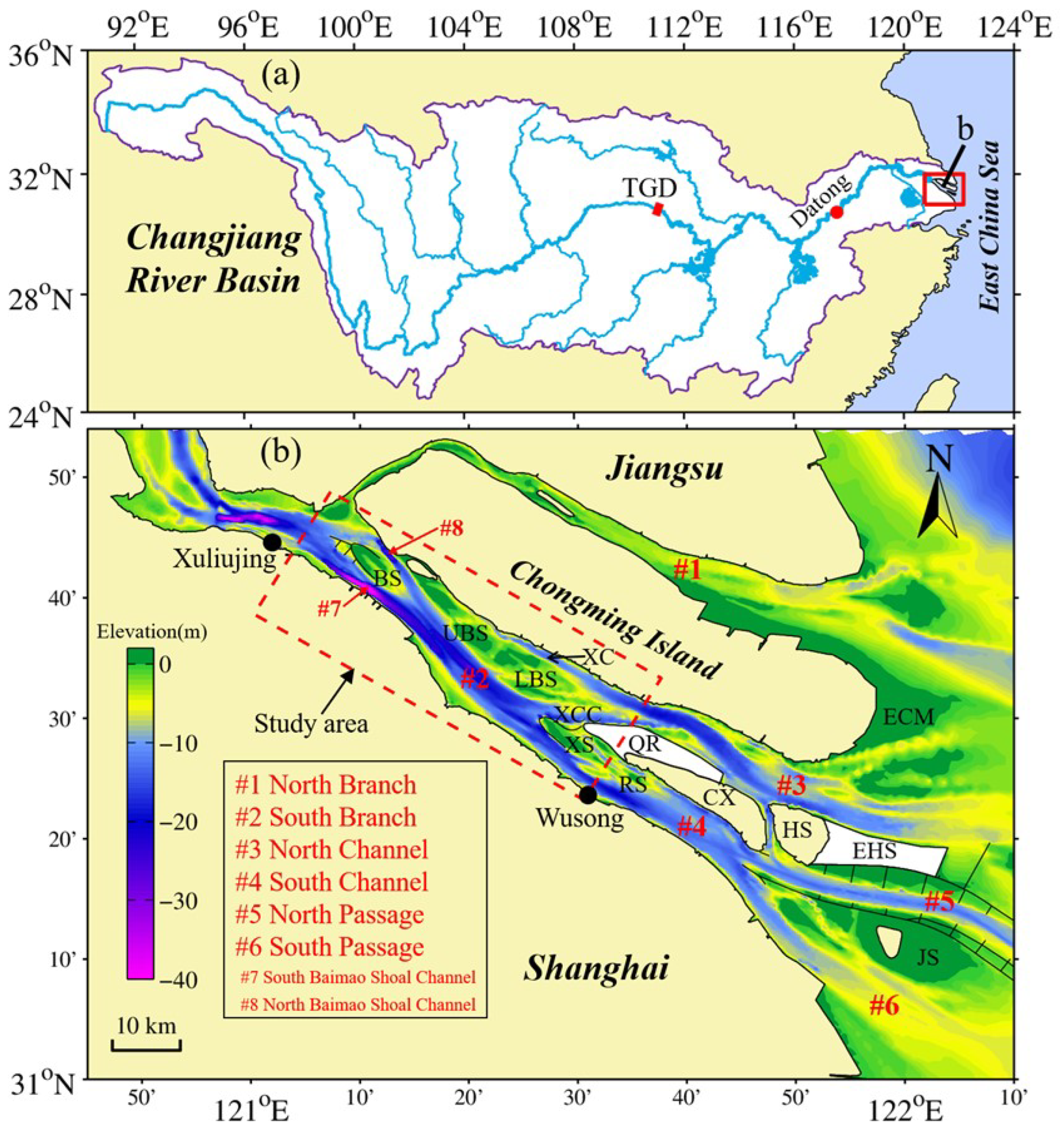
Figure 2.
Variations of annual river runoff and sediment load at the Datong station (tidal limit).
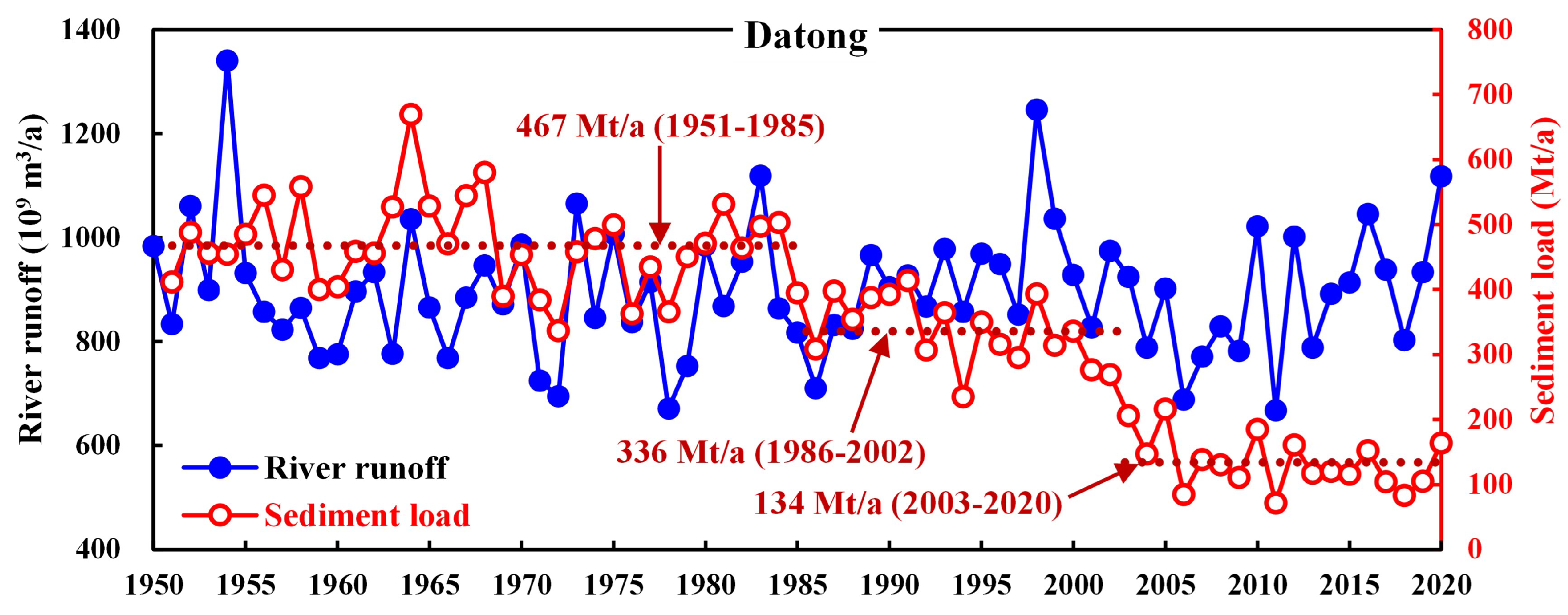
Figure 3.
Layout of grids for simulation and the topography in December 2016.
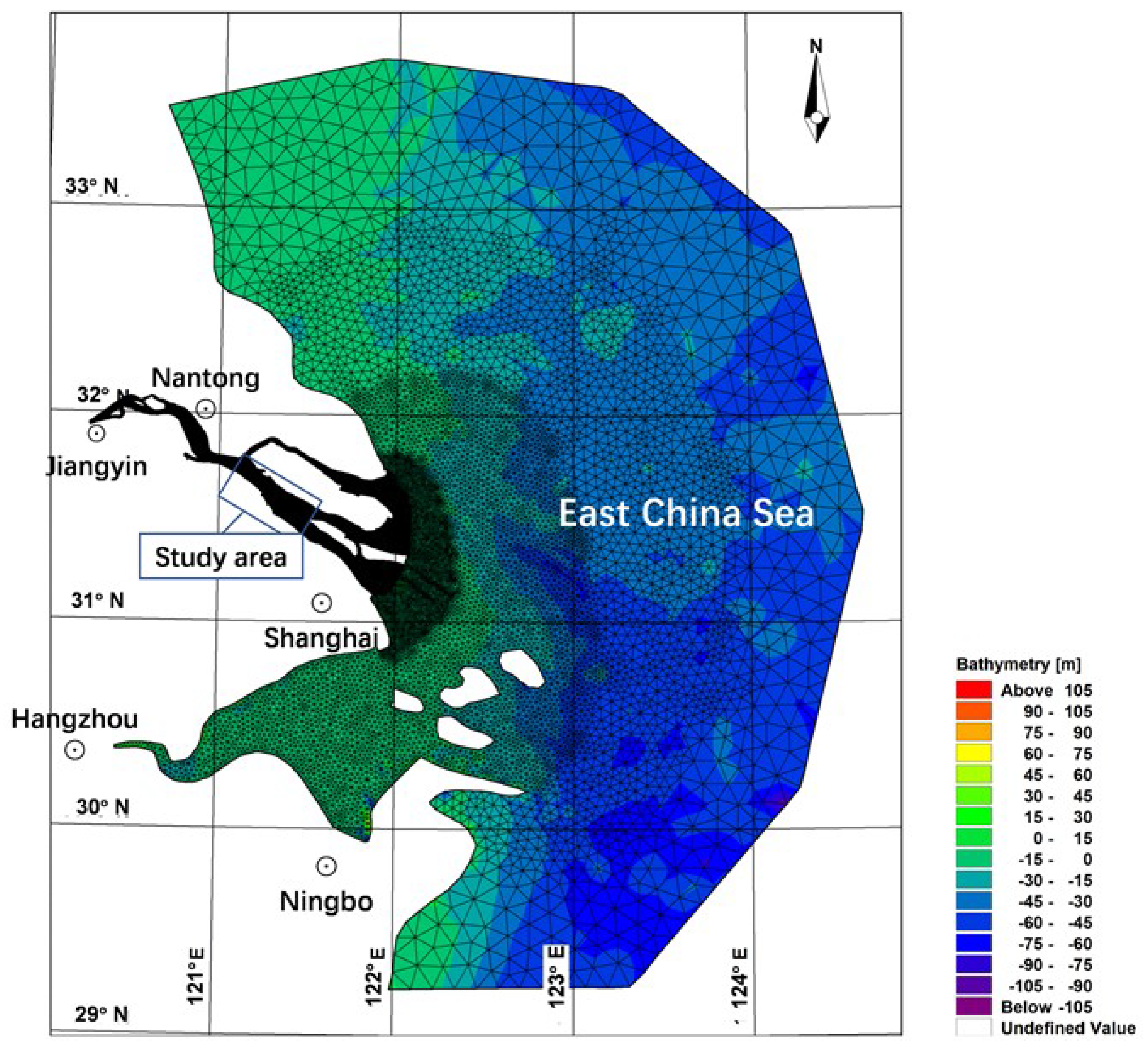
Figure 4.
Inflow boundary condition of water flow discharge (Q) and suspended sediment concentration (SSC) at Jiangyin.
Figure 4.
Inflow boundary condition of water flow discharge (Q) and suspended sediment concentration (SSC) at Jiangyin.
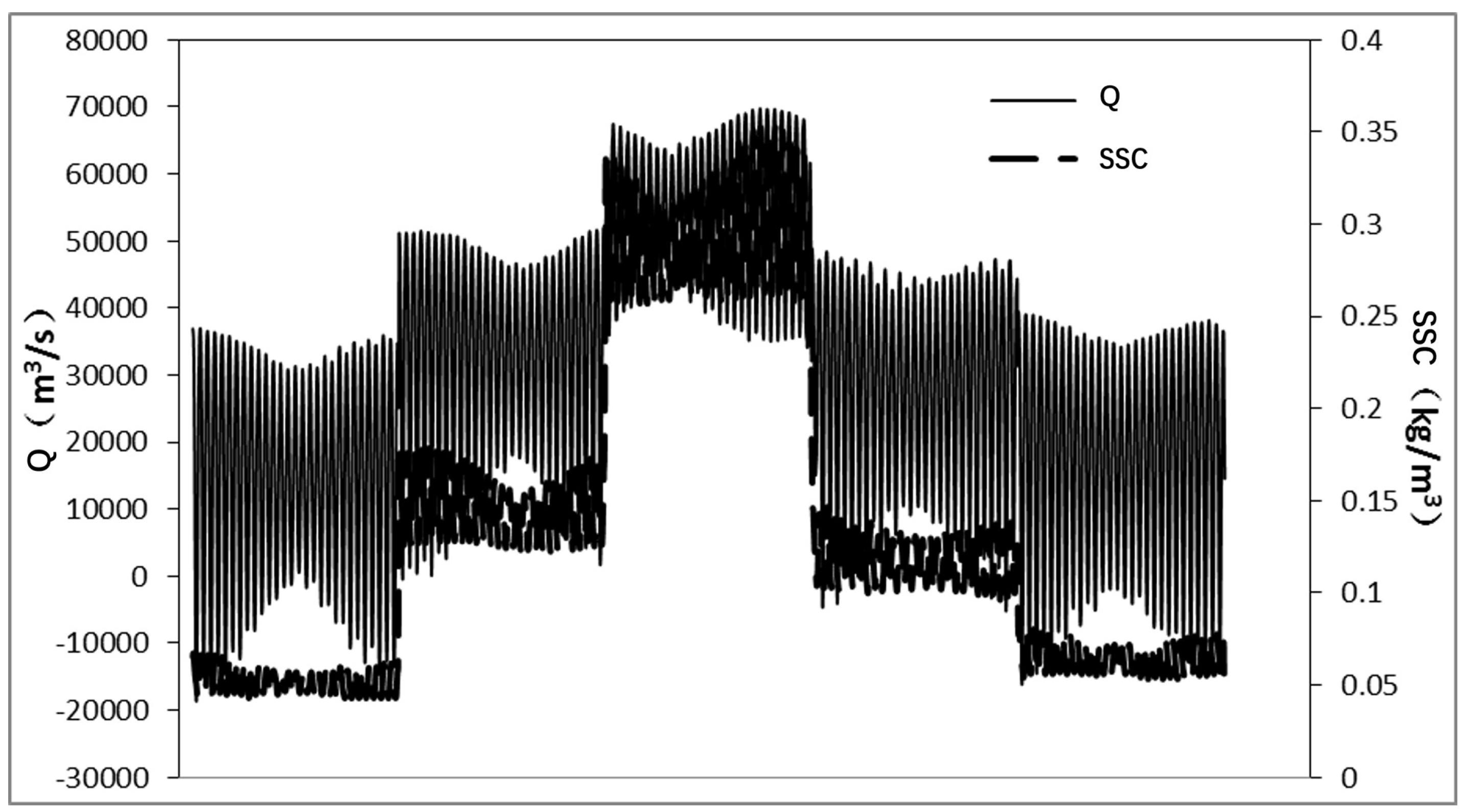
Figure 5.
Monitoring points and cross sections.
Figure 6.
Bathymetry of the South Branch observed in multiple years: (a) 1958, (b) 1978, (c) 1986, (d) 1997, (e) 2007, and (f) 2016.
Figure 6.
Bathymetry of the South Branch observed in multiple years: (a) 1958, (b) 1978, (c) 1986, (d) 1997, (e) 2007, and (f) 2016.
Figure 7.
Erosion and deposition patterns of the South Branch in different periods: (a) 1958–1978, (b) 1978–1986, (c) 1986–1997, (d) 1997–2007, and (e) 2007–2016.
Figure 7.
Erosion and deposition patterns of the South Branch in different periods: (a) 1958–1978, (b) 1978–1986, (c) 1986–1997, (d) 1997–2007, and (e) 2007–2016.
Figure 8.
Hypsometry curves of the South Branch for multiple years (1958, 1978, 1986, 1997, 2007, and 2016) (see the domain in Figure 1b).
Figure 8.
Hypsometry curves of the South Branch for multiple years (1958, 1978, 1986, 1997, 2007, and 2016) (see the domain in Figure 1b).
Figure 9.
Deposition thickness of the South Branch in 20 years.
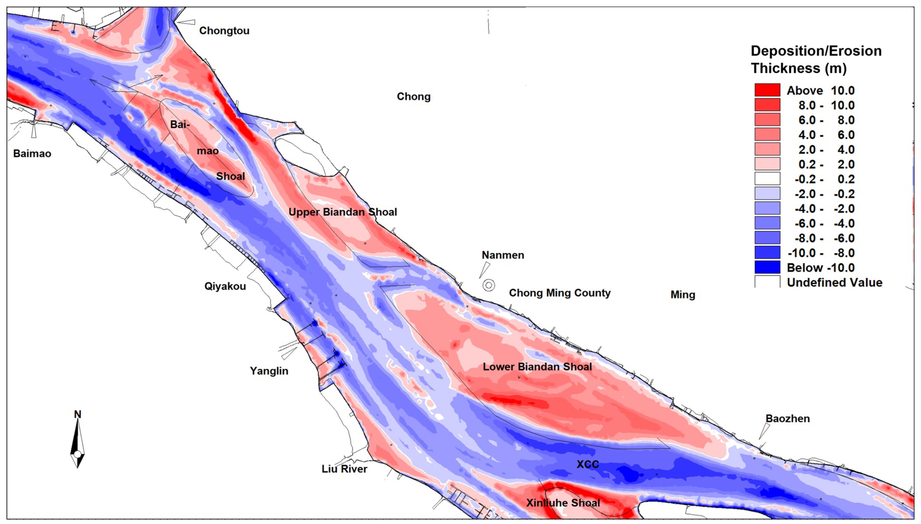
Figure 10.
Layout of governance measures for the Baimao Shoal and Biandan Shoal (the blue lines represent the governance measures, while the black lines represent the existing structures).
Figure 10.
Layout of governance measures for the Baimao Shoal and Biandan Shoal (the blue lines represent the governance measures, while the black lines represent the existing structures).
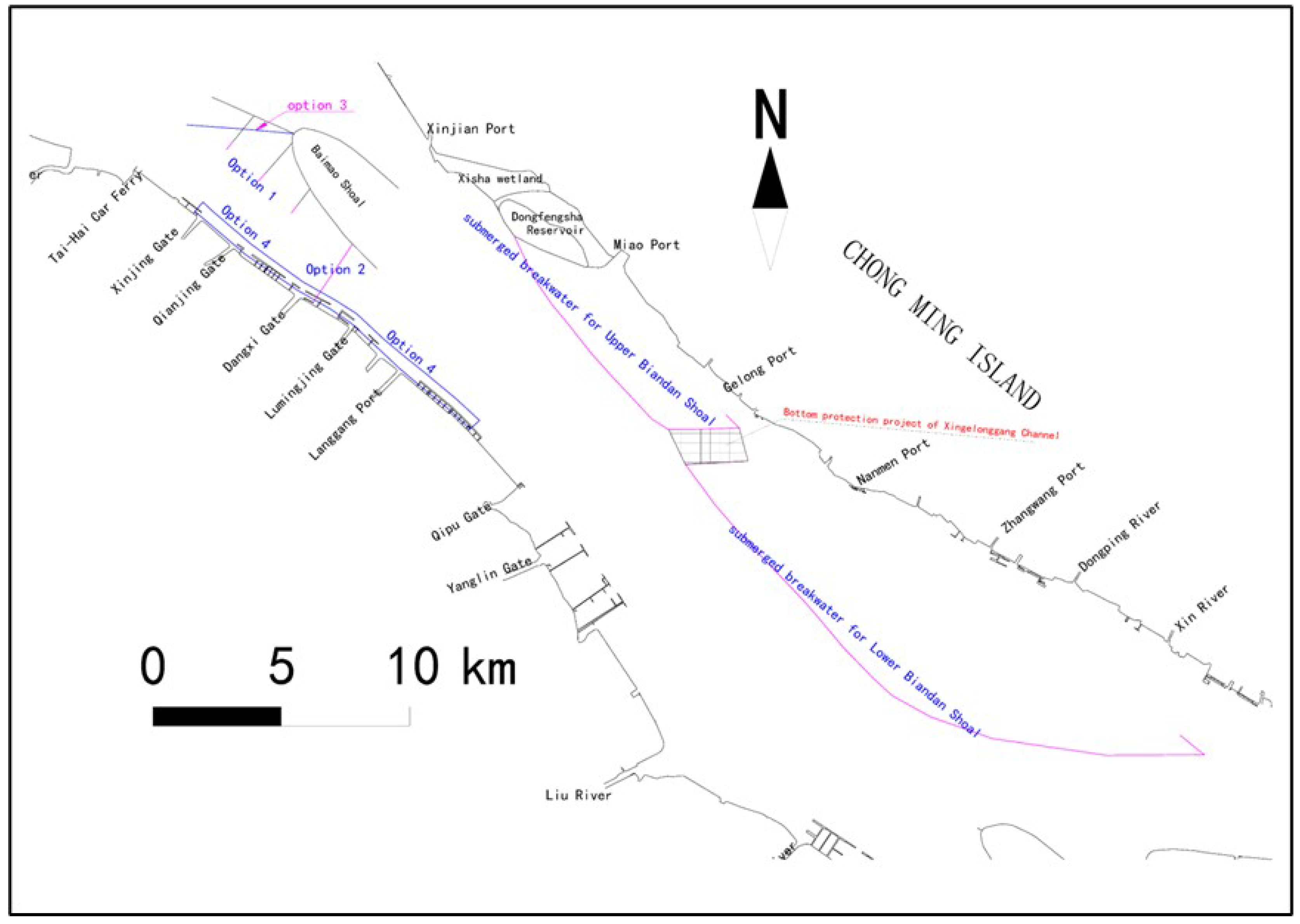
Figure 11.
Variation of the high tide level under the influence of combined governance measures of option 4.
Figure 11.
Variation of the high tide level under the influence of combined governance measures of option 4.
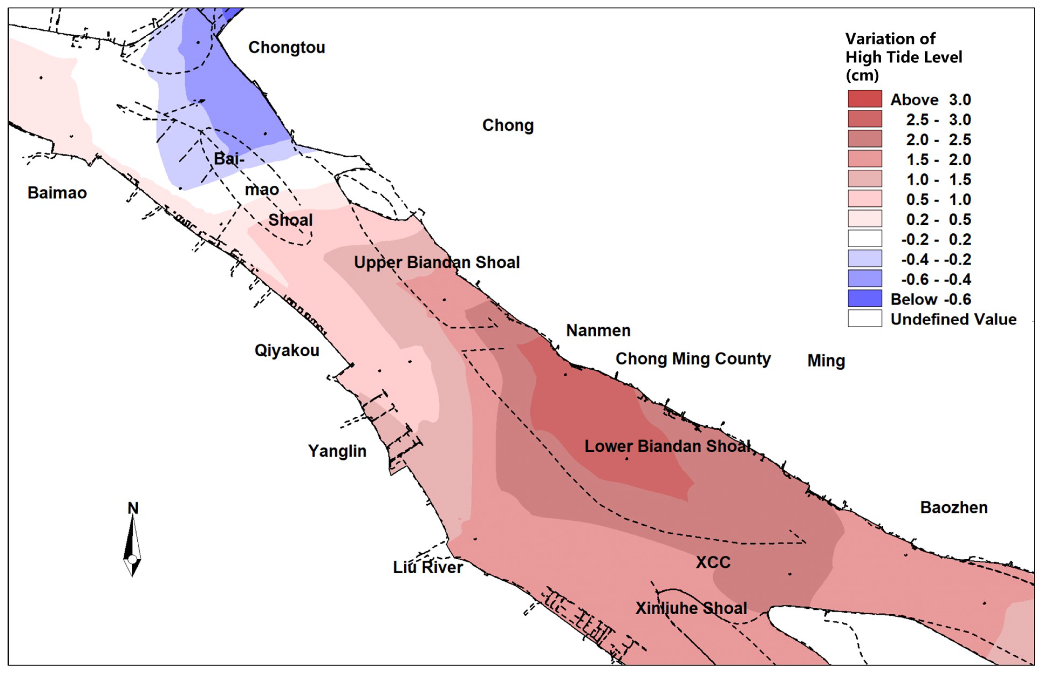

Table 1.
Names of monitoring points.
| ID | Name | ID | Name | ID | Name |
|---|---|---|---|---|---|
| p1 | Wangyu River | p11 | The South Passage | p21 | Lianxing Port |
| p2 | Xuliujing | p12 | Liuxiao | p22 | Main Channel at Xuliujing |
| p3 | Outlet of Baimao River | p13 | Baozheng | p23 | South Baimao Shoal Channel |
| p4 | Outlet of Dangxi River | p14 | Nanmen | p24 | North Baimao Shoal Channel |
| p5 | Qiyakou | p15 | Chongtou | p25 | Upper Biandan Shoal |
| p6 | Outlet of Liu River | p16 | Rixinhe | p26 | Lower Biandan Shoal |
| p7 | Outlet of Wusong River | p17 | Qilong Port | p27 | Main Channel of the South Branch |
| p8 | Hengsha Shoal | p18 | Lingdian Port | p28 | Xinqiao Connecting Channel |
| p9 | The North Passage | p19 | Touxing Port | p29 | Main Channel of the South Channel |
| p10 | The North Channel | p20 | Santiao Port | p30 | Main Channel of the North Channel |
Table 2.
Governance measures for the Baimao Shoal.
| No. | Governance measures for the Baimao Shoal |
|---|---|
| 1 | Lengthen the three tooth dikes at the south of the Baimao Shoal outward by 400 m, and keep the elevation of its head as -7 m. |
| 2 | Set a submerged dam in the South Baimao Shoal Channel with a crest elevation of -20 m. |
| 3 | Rebuild the thorn dam connecting to the west vertex of the Baimao Shoal, keep the connecting point still, and deflect it counterclockwise. The crest elevation of the new thorn dam is -3 m to 0 m, and the length is approximately 1.8 km. |
| 4 | Cover the Taicang beach in front of the right bank of the South Baimao Shoal Channel from Xinjing Gate to Lang Port. The covered area extends to a length of 13 km and has the lowest elevation of -20 m. |
Table 3.
Governance measures for stabilizing Biandan Shoal.
| No. | Content of the measures | |
|---|---|---|
| 1 | The content in the three options is the same and is as follows. | Crest elevations of the breakwaters are +2.5 m. |
| 2 | The submerged breakwater at the right edge of the Upper Biandan Shoal is arranged along a -2 m contour line. | Crest elevations of the breakwaters are 0 m. |
| 3 | The upper part of the submerged breakwater at the right edge of the Lower Biandan Shoal is along the -2 m contour line. The lower part is arranged along the -4 m contour line. | Crest elevations of the breakwaters are -0.5 m. |
Table 4.
The combined measures for stabilizing the Baimao Shoal and Biandan Shoal.
| No. | Baimao Shoal governance measures | Biandan Shoal governance measures |
|---|---|---|
| 1 | Rebuild the thorn dam connecting to the west vertex of the Baimao Shoal, keep the connecting point still, and deflect it counterclockwise. The crest elevation of the new thorn dam is -3 m to 0 m and the length is approximately 1.8 km. | The content in the four options is the same and is as follows. |
| 2 | Lengthen the three tooth dikes at the south of the Baimao Shoal outward by 400 m, and keep the elevation of its head as -7 m. | The submerged breakwater at the right edge of the Upper Biandan Shoal is arranged along the -2 m contour line. |
| 3 | Set a submerged dam in the South Baimao Shoal Channel with a crest elevation of -20 m. | The upper part of the submerged breakwater at the right edge of the Lower Biandan Shoal is along the -2 m contour line. The lower part is arranged along the -4 m contour line. |
| 4 | Measure content in both options 1 and 2. | Crest elevations of the submerged breakwaters are -0.5 m. |
Disclaimer/Publisher’s Note: The statements, opinions and data contained in all publications are solely those of the individual author(s) and contributor(s) and not of MDPI and/or the editor(s). MDPI and/or the editor(s) disclaim responsibility for any injury to people or property resulting from any ideas, methods, instructions or products referred to in the content. |
© 2024 by the authors. Licensee MDPI, Basel, Switzerland. This article is an open access article distributed under the terms and conditions of the Creative Commons Attribution (CC BY) license (https://creativecommons.org/licenses/by/4.0/).
Copyright: This open access article is published under a Creative Commons CC BY 4.0 license, which permit the free download, distribution, and reuse, provided that the author and preprint are cited in any reuse.


