
Submitted:
03 October 2024
Posted:
04 October 2024
You are already at the latest version
Abstract
Urban Heat Islands (UHI) are a growing concern in rapidly urbanizing regions, leading
to significant ecological and public health challenges. This study investigates the spatiotemporal dynamics of UHI intensity in Mbombela City, Mpumalanga Province, South
Africa, from 2008 to 2023. Using Landsat satellite imagery and geospatial analysis
techniques, the research quantifies changes in land cover and their impact on Land
Surface Temperature (LST) and UHI intensity. The results show that built-up areas
increased by 86.67% over the study period, while vegetation cover decreased by
22.22%. Mean LST rose from 28.3°C in 2008 to 30.1°C in 2023, indicating a significant
intensification of the UHI effect. Statistical analyses reveal strong correlations between
urbanization metrics and UHI intensity, highlighting the role of human activities in
exacerbating this phenomenon. This research contributes valuable insights for urban
planning and climate adaptation strategies, particularly in secondary cities like
Mbombela, where rapid development is creating new environmental challenges. The
findings underscore the need for green infrastructure and nature-based solutions to
mitigate the negative impacts of urbanization.
Keywords:
UHI
; Land Surface Temperature (LST)
; Spatio-Temporal Analysis
; Urbanization
Chapter 1: Introduction
1.1. Background
Population increase and rapid development characterised by the growth of infrastructures especially in urban centres has
greatly affected the landscapes thus; bringing forth different environmental issues such as Urban Heat Island (UHI) which is defined as increased
temperatures in urban regions as compared to rural ones, mainly due to urban structures replacing natural landscapes with hard surfaces, including the roads
and pavements that trap heat (Sarkar and De Ridder, 2022). This issue is exacerbated by the removal of vegetation, which disrupts natural cooling
processes like shading and evapotranspiration (Li, Zhang, & Kainz, 2021). The UHI intensity has broad impacts that stretch beyond a rise in temperatures,
which is what most people appreciate it for when mentioning the term. It also increases energy usage because of additional use for air conditioning especially
during summer thus promoting the production of greenhouse gases, which in turn cause global warming (Heaviside et al., 2017). Thirdly, it also poses
significant risks to the health of the public, especially during heat waves. The mortality rates are also likely to increase due to heat related diseases,
especially for the elderly, children and other people who are susceptible to clinical illnesses (Sharma et al., 2019). In South Africa, the impacts of UHI
have been most felt in capital cities where urbanization is manifesting in areas such as Mbombela in the Mpumalanga Province. In the last few decades, the
population has grown rapidly within this province and urban growth to advanced levels, thus resulting in changes in land use and landscape patterns (Musakwa
et al., 2020). For instance, the total number of people in Mbombela ascended from approximately 577000 in 2008 to about 833000 in 2023, accompanied by a
rise in built-up regions (Statistics South Africa, 2023). Even though the UHI intensity is considered as one of the most significant environmental and a
major public health issue, there is still a huge lack of knowledge about its spatio-temporal patterns especially for developing cities (Chakraborty et al.,
2020). Prior research has chiefly adopted global or country-level research approaches while comparatively less emphasis was placed on local or city level
examination of factors pertinent to the dynamics of distinct urban ecosystems (Gunawardena et al., 2017). This research seeks to meet this important research
gap by undertaking a detailed analysis of the changes in UHI in Mbombela from 2008 to 2023. In so doing, we offer unique insights into the little researched
UHI dynamics that are apparent in other secondary cities in South Africa. This research discusses socio-economic factors while focusing on UHI, and thus,
offers a more comprehensive approach to identifying and studying vulnerabilities related to heat islands in Mbombela, using its specific urban characteristics.
1.2. Research Problem
The expansion of Mbombela City has brought about major changes in land use, largely defined by a reduction in vegetation as well as an increase in areas built up. As a result, this has raised the heat island effect, causing surface temperatures to escalate and microclimates in the urban core to change.
1.3. Research Questions
- What are the spatial and temporal trends of UHI intensity in Mbombela from 2008 to 2023?
- What are the underlying factors contributing to UHI in Mbombela City?
1.4. Research Aim and Objectives
This study aims to assess the spatio-temporal analysis of UHI intensity in Mbombela City, Mpumalanga Province from 2008 to 2023.
Specific objectives:
- To map and quantify the spatial distribution and temporal trends of UHI intensity in Mbombela from 2008 to 2023 using remote sensing and GIS techniques.
- To identify and analyse the underlying drivers of UHI in Mbombela City.
1.5. Significance of the Study
This research gives essential understanding of the environmental results caused by swift urbanization in secondary cities, with an emphasis on UHI intensity. This research will yield important results for urban planners, those who create environmental policy, and climate change adaptation specialists, especially in developing countries such as South Africa. The identification of major UHI drivers and the analysis of temperature change spatial patterns allows this study to inform upcoming urban development policies that focus on decreasing the UHI effect and fostering sustainable city expansion.
1.6. Delineation of the Study
This study focuses exclusively on the assessment of UHI intensity within the urban region of Mbombela City, located in Mpumalanga Province, South Africa, over a fifteen-year period from 2008 to 2023. The analysis is confined to the urban and peri-urban areas of Mbombela, without comparison to rural areas or neighboring municipalities. The research is centered on assessing changes in land cover and land surface temperature using remote sensing data and GIS technologies.
Other environmental factors, such as airborne pollutants, socio-economic conditions, and hydrological influences, are not included in this analysis. The study also does not delve into other UHI intensity indices or their interactions with population density and land-use changes. Broader macro-level trends, including climate change, as well as more localized meso- and micro-weather patterns, fall outside the scope of this research. While the findings provide valuable insights as a case study for Mbombela, the conclusions are not intended to be generalized to other cities or regions without further comparative studies.
1.7. Dissertation Layout
This mini dissertation is structured as follows:
Chapter 1: Introduction – This chapter provides the background of the study, research questions, problem statement, objectives, and the importance of the study. It also covers the conduct and significance of the research, as well as the delimitation of the study.
Chapter 2: Literature Review – This chapter reviews existing literature on Urban Heat Island Intensity (UHII) in both global and regional contexts. It discusses the effects of UHIs on temperature, the impact of urbanization on vegetation removal or reduction, and the role of green infrastructure in controlling UHI.
Chapter 3: Study Area and Methodology – This chapter presents the geographic context of the study and outlines the data collection, processing, and analysis strategies. It also details the main remote sensing and GIS tools used to examine UHI intensity.
Chapter 4: Results and Discussion – This chapter presents the research findings regarding land-use changes, UHI intensity, and statistical analyses. The results are discussed in relation to relevant previous studies.
Chapter 5: Conclusion and Recommendations – The final chapter summarizes the research findings and assesses the achievement of the study objectives. It also outlines the implications for urban planning and provides recommendations for future research.
Chapter 2: Literature Review
This chapter explores the body of existing research relevant to the Urban Heat Island (UHI) phenomenon, focusing on its causes, impacts, and the methods employed in analysing its spatial and temporal patterns. The review also examines key studies on land cover classification, remote sensing technologies, and urbanization trends that inform this research.
2.1. The Urban Heat Island Phenomenon: A Global Perspective
Many cities around the globe have been experiencing the Urban Heat Island (UHI) impact Such temperature difference has been described since the early 1800s by Luke Howard and it has become more noticeable in recent decades (Mohajerani et al., 2017). That is why the UHI intensity is not just an interesting idea that scientists discuss in their papers; it affects the future of cities, people’s health, and climate change solutions (Li et al., 2021; Sharma et al., 2019). New findings have provided an understanding of the scale of UHIs worldwide. For example, in a global study of 1692 cities by Rizvi and others (2021), the authors found that UHI intensity was significantly associated with population density and urban extent. Accordingly, the authors’ conclusions indicate the increased vulnerability of fast-growing urban environments in developing countries to worsening heat island conditions. This global perspective is important in regard to determining potential patterns through which UHIs might evolve in other emerging urban centres like Mbombela, South Africa.
2.2. Unraveling the Complexities of Urban Heat Islands
Urban Heat Islands represent a multidimensional issue propelled by natural and anthropogenic components. Multiple contributing variables, consisting of land cover shifts, heat-retaining materials, anthropogenic heating sources, and urban geometry, are the source of UHI formation. Such complexity is further aided by regional climatic and socio-economic differences. The substitution of natural landscapes by impervious surfaces, namely asphalt and concrete, is a key part of UHI. These materials capture and keep heat throughout the day, slowly giving it off at night, causing urban areas to be hotter than surrounding countryside. Li et al. (2021) have demonstrated that local temperatures can increase by up to 3°C because of impervious surfaces. This outcome shows heterogeneity, since the distribution and composition of these surfaces change within different urban scenarios, thereby adding an additional layer of complexity to UHI dynamics. Besides, anthropogenic heat sources including vehicle emissions, industrial activities, and air conditioning systems add to UHI. In densely settled locales, the anthropogenic heat flux may go as high as 100 W/m² (Heaviside et al., 2017), making local temperatures even worse. UHI has become an even more difficult matter to regulate because the inclusion of anthropogenic heat necessitates a combination of urban design and societal behavioral changes.
Throughout urban geometry, particularly the design of buildings and streets, plays an important part in the formation of UHI. Urban canyons, resulting from narrow streets and tall buildings, catch heat and minimize air circulation, resulting in a hard time for heat to dissipate. This generates local "hot spots" in the city, characterized by temperatures that are considerably greater than in other neighborhoods. Yang et al. (2020) found that urban geometries may be responsible for variations in temperature of up to 2°C within a single urban area. Also, the decline of vegetation resulting from urban extension intensifies UHI by reducing natural cooling processes of shading and evapotranspiration. Analysis reveals that a 10% lowering in vegetation may cause temperature increases ranging from 0.5°C to 2°C (Gunawardena et al., 2017). This brings attention to the value of blending green spaces and urban forestry into the process of city planning to help mitigate the ramifications of UHI. A further key factor is the impact of UHI and climate change on each other. Amplification of local warming by UHI can occur because of global climate change, instigating a feedback loop that intensifies and lengthens heat waves. In a number of cities, Zhao et al. (2018) discovered that local climate change explained more than 70% of the recognized temperature increases. The addition of a global element to the UHI problem makes it even more complex to manage at the local level. In essence, the Urban Heat Island phenomenon comes from complicated, intertwined factors that include land cover evolution, anthropogenic heat emissions, urban form, and the depletion of vegetation. Also, the links between local urban developments and global climate patterns mean that UHIs are a key issue for both urban planners and those formulating environmental policy. A comprehensive solution for UHI must integrate urban design, green infrastructure, and climate adaptation strategies in order to efficiently mitigate its impacts.
Table 2.1 summarises the key contributors to urban heat island intensity, highlighting the multifaceted nature of the UHI phenomenon.
As mentioned in the table above, some of the key variables that determine the level of UHI include the impervious surfaces, anthropogenic heat, vegetation reduction, urban geometry, and climate change. Due to these interactions, it becomes evident that different research and mitigation approaches are needed for UHI studies.
2.3. Urban Heat Islands in the African Context
In the context of the African continent, different and rapidly growing urbanisation rates, and outstanding environmental conditions create a special approach to investigating UHI Intensity. Africa’s cities encompass mostly the informal built environment, scarce or unfavourable for UP, and rapidly growing populations which makes it necessary to work out unique strategies to apprehend and address the consequences of UHI impact. A good example of UHI research in an African context is Mukwada and Manatsa (2018) study conducted in Harare, Zimbabwe. Their work, done between the years 2000 and 2015, established remote sensing as a useful tool in the study of UHI in African cities. The researchers found positive associations between LC and UHI and the district’s average temperature with the areas that had higher rates of urbanisation having higher temperatures of up to 2. 5°C than the corresponding stable urban areas. This study suggested enhanced measures towards interdisciplinary Urban planning for African cities while addressing the thermal consequences of all the physical land use changes.
Ayanlade and Jegede (2021) examined and compared UHI trends for Lagos in Nigeria and Accra in Ghana in West Africa. Nonetheless, both cities had substantial UHI Intensity – intensity differences of up to 3 in both urban structures were observed. 4°C and 2. And during the dry season 30°C by day and 8°C during the night, accordingly. This research elaborated on the need to take into account the climatic variations and seasonal characteristics in the investigation of UHI in different African towns.
2.4. South Africa's Urban Heat Island Landscape
South Africa is among Africa’s most urbanised countries and thus has been at the vanguard of UHI research in Africa. Due to its large population, the country has immense urban diversity covering large arrays extending from large metropolitan cities to emerging secondary cities and this makes the country a perfect setting to study UHI Intensity in different developing urban settings. In a detailed study of the trends of temperature in Tshwane Metropolis, Adeyemi et al. (2019) identified the change in the surface cover composition particularly in impervious surface area as well as vegetation cover loss to increase the mean surface temperature. Using the remote sensing data coupled with field measurements, their findings were that in highly urbanised areas the temperature increase can be up to 4 °C as compared to peri-urban areas. As it was seen in the research, green infrastructure was effective in combating UHI with the areas that had more than 40% of vegetation cover exhibiting much lower surface temperatures. In line with such ideas, Fitchett and others (2022) follow up on this work by providing an examination of the UHI intensity in major metropolitan cities of South Africa. Their study, encompassing Johannesburg, Cape Town, Durban, and Pretoria, revealed distinct spatial and temporal variations in UHI intensity: Their study, encompassing Johannesburg, Cape Town, Durban, and Pretoria, revealed distinct spatial and temporal variations in UHI intensity:
- The research also revealed that Johannesburg had the highest intensity of UHI with the maximum rising to 5. It is rather cool during the nighttime in summer with the mercury touching 2°C influenced by factors such as its highly concentrated urban centre and major land modification occasioned by mining activities.
- This ‘urban heat island’ was more moderate than in Johannesburg in Cape Town, with a maximum increase of around 3. 8°C and this may be due to the coastal nature of Cape Town as well as its topographical characteristics.
- The overall trend in the UHI of the city was well-explained by the coastal features and varying density of built-up areas of Durban; the hotspots of the UHI were recorded as up to 4. 5°C above surrounding areas.
- It was well illustrated by the Pretoria data where it appeared that there was a strong link to UHI intensity with socio–economic gradients; with upscale neighbourhoods recording lower temperatures owing to afforestation.
The multi-city perspective highlighted the fact that the geographical and socio-economic conditions of a city matter while analysing and managing UHI impacts.
2.5. Focusing on Secondary Cities: The Case of Mbombela
Although many of the major metropolitan areas of South Africa have been investigated for UHI, there are limited comprehensive, long-term studies on secondary cities. This is especially important in urbanising cities like Mbombela, which are experiencing rapid growth and development characterised by dramatic land-use changes, environmental degradation and limited funding and capacity to adapt to climate change impacts. In this regard, Mbombela, the capital and a secondary city in Mpumalanga Province, is a valuable place to research UHI in secondary cities in South Africa. Mbombela's geographic position, which is rapidly urbanising, and its varied topography contribute to the city's case for UHI research and analysis of UHI intensity's spatio-temporal pattern. For example, a recent study examined urban resilience in relation to UHI in the secondary cities of Mpumalanga was undertaken by Musakwa et al. (2020). This research acknowledged that climate adaptation plans needed to be undertaken at a local level to address identified climate impacts within the context of Mpumalanga's urban areas. Although that study did not explore UHI Intensity, it was able to highlight relevant environmental challenges in secondary cities in Mpumalanga, South Africa. Additionally, there has been little existing research regarding the urban environment of Mbombela, which causes an urgent care for UHI investigation. It is worth referring to a preliminary study by Mahlaka and Eloff (2022), which examined land-use changes and their effects within the rainfed farming systems of Mbombela from 2000 to 2020; there was reported to be a 37% increase in built-up urban land-use recorded, with a corresponding 28% decrease in natural vegetation in just twenty years. Although this study does not quantify UHI intensity, it measured rapid spatial change in an environmentally sensitive area of Southern Africa (e.g., Mbombela situated within the savannah biome). Thus, the potential increase in urbanisation could be compounding UHI Intensity.
2.6. Methodological Advancements in UHI Research
Technological innovation and advancement, particularly in remote sensing and GIS, has transformed research and scholarship about the UHI phenomenon. These technologies provide possibilities for new investigations of UHI dynamics in Mbombela, and possibly in other cities where methods for gathering ground-based measurement is limited or non-existent. Chakraborty et al. (2020) created a modern UHI surface database that is spatially explicit for the United States and demonstrated how these technologies are emerging in precise, and detailed assessments of UHI. They blended multi-source satellite imagery and machine learning methods to construct UHI maps with spatial resolution of 30 meters, representing some of the most advanced UHI studies to date and this approach could be modified and applied in South African cities and yield a critical source for improvement of high-resolution UHI studies and its association to urban morphology. In an African context, Simwanda et al. (2019) explored UHI in Lusaka, Zambia based on the innovative application of Landsat imagery and LCZ classification. Their work presented a thorough understanding of UHI patterns based on incorporating some spectral indices, including NDVI and NDBI, while also considering urban form and UHI activity based on LCZ classification. The model presented in their research may be relevant in the ongoing study in Mbombela, where a distinct urban area has experienced rapid urbanization and development.
2.7. Socio-economic Dimensions of Urban Heat Islands
The literature has increasingly focused on the socio-economic dimensions linked to UHI, especially given the greater awareness of the unequal distribution of impacts of extreme heat between vulnerable communities. This emerging perspective has particular relevance for South Africa, with past spatial segregation and continued socio-economic inequalities in the country from a historical context. Hoffman et al., (2020) examined UHI in conjunction with historical housing policy, focusing specifically on intra-urban heat exposure across differing socio-economic groups within selected cities in the USA. Their findings demonstrated that former red-lined neighbourhoods had temperatures 7°C higher than non-, red-lined neighbourhoods, strongly indicating the continued environmental justice implications of urban planning and policy even generations later. In South Africa, Naidoo et al., (2021) examined UHI Intensity and socio-economic vulnerability in the case of Durban. Their results indicated that informal settlements and low-income areas experienced UHI intensities of 2.5°C more than affluent areas and generally exacerbated existing economic and health inequalities. The article discusses the importance of incorporating social equity in UHI mitigation plans, particularly in the context of historical spatial inequality, in reference to Mbombela specifically.
2.8. Mitigation Strategies and Green Infrastructure
A concentrated area of recent research involves finding effective UHI mitigation approaches, wherein researchers have begun to land on green infrastructure as a solution. Urban planning that includes nature-based solutions has a great deal of potential to lessen the impacts of UHI and improve overall climate resilience in urban areas. Gunawardena et al. (2017) completed a meta-analysis of 75 studies, providing an extensive literature review on how effectively green and blue spaces can reduce UHI intensity. Their results highlighted that urban park conferred an average cooling effect of 0.94°C, with parks that were larger than ten hectares conferring an even greater cool of approximately 1.5°C. Gunawardena et al. (2017) also reported the need to locate and design green spaces thoughtfully, in order to ensure cooling effects permeate a larger area and are maximised. Adepeju et al. (2022) studied whether urban parks conferred a cooling effect on urban areas in Pretoria, South Africa and found that urban parks could reduce the surrounding temperature, utilising remote sensing data and in-situ temperature measurements. Their study found that large urban parks (>20 hectares) could reduce surface temperatures on average, by up to 3°C lower than the moderated built-up area surrounding the park. Notably, Adepeju et al. (2022) highlighted the cooling effect also extended beyond the footprint of the park, into neighbourhoods up to approximately 350m surrounding the park's boundaries.
Table 2.2 provides an overview of the effectiveness of various UHI mitigation strategies, as reported in recent literature.
As illustrated in Table 2.2, various strategies, from large urban parks to cool pavements, can contribute to UHI mitigation. The varying temperature reductions and spatial extents of impact highlight the importance of a multi-faceted approach to urban cooling.
2.9. Chapter Summary and Research Gaps
The literature review has underscored the need for UHI research in general and specifically in the African and the South African context; yet more importantly is the need for further sharpened research on secondary cities such as Mbombela. The more complex application of the remote sensing techniques, the incorporation of socio-economic aspects as well as identification of better ways of mitigating the effects become topics for research.
Specific research gaps identified for Mbombela city include:
- Amount of UHI intensity for a long-term spatio-temporal analysis over the city with reference to urban sprawl after early 2000s.
- Evaluation of the link between changes in land use and the distribution of UHI with a focus on relatively new development.
- Contingent analysis of UHI exposure inequality by socio democrat and its implications for environmental equity.
- On the feasibility and impact of the current existing green space skyline and assessment of UHI Intensity and future green plans.
- Combining point-based meteorological data with satellite retrievals to obtain a holistic picture of UHI processes in the context of Mbombela’s climate.
In general, these guided the choice of the study area, and the adopted methodology as explained in the next chapter.
Chapter 3: Study Area and Methodology
3.1. Study Area
The study area is Mbombela City with coordinates 25.4652° S and 30.9785° E in Mpumalanga Province, South Africa. It used to be called Nelspruit, Mbombela is the capital city of the Province and the town occupies a huge land of about 7141 square kilometers (Mbombela Local Municipality, 2020). Several types of land covers are evident in the city they include urban, Agricultural and natural vegetation covers. The geographical location of the study area is shown in Figure 3.1 below
Mbombela has sub-tropical climate with mean annual temperatures of between 19 ° C and 29 ° C (South African Weather Service, 2022). Rainfall is mostly received during summer season and averages 800mm per annum with the rainfall periods being from October to March (Mbombela Local Municipality, 2020). It experiences a good climate and a favourable ground formation suitable for supporting the region’s diverse Wildlife and various farming. The city’s population has increased from 588,794 in 2008, and to 735,627 in 2023 (Statistics South Africa 2023). This condition has caused changes in the land use and city form, therefore making Mbombela town appropriate for the investigation of urban heat island (UHI).
3.2. Research Design
This research used a quantitative research approach based on Remote Sensing and Geospatial Analysis to analyse the spatio-temporal variation of the UHI effect in Mbombela. In detail, the particular research interest included multi-temporal satellite image analysis, LST, NDVI, and NDBI, as well as statistical and spatial modeling. These methods were chosen because they have been proven to be effective at both identifying the changes in land cover and urban heat patterns as seen below in the literature (Li et al., 2020; Zhang et al., 2021). The research design flowchart is as shown below; Figure 3.2 Research Design Flowchart.
3.3. Data Acquisition and Preprocessing
3.3.1. Satellite Imagery
Landsat 5 Thematic Mapper (TM) and Landsat 8 Operational Land Imager (OLI) imagery were obtained from the United States Geological Survey EarthExplorer (https://earthexplorer.usgs.gov/) for 2008 and 2023, respectively.
Image selection criteria included:
- Less than 10% cloud cover was employed as a criterion to assess the quality and clarity of the satellite imagery as is the norm in remote sensing literature. For instance, Smith et al. (2021) used the same threshold of cloud cover for the assessment of urban growth based on Landsat data as they avoid errors resulting from atmospheric disturbances. In a similar manner, Zhang et al. (2022) used a criterion of less than 10% cloud cover in the study of land cover change for enhancing the quality of the land surface temperature (LST) retrieved. This threshold is to avoid contamination from cloud cover since it does not interfere with the quality of data used for analysis.
- Purchases are made in the winter, which in Mbombela lasts from May to September. In this period, there is little precipitation, and the sky is less cloudy than other seasons, which makes it convenient to obtain satellite remote sensing data with less cloud cover. It follows that the rates of LST and land cover data are relatively better during the winter season, due to the reduced moisture levels in the atmosphere.
- To maintain temporal coherency similar acquisition times have been used which is a common practice in remote sensing studies. For example, Zhao et al. (2021) used the same TOD image acquisitions to eliminate the variations of the solar radiation in identifying the UHI impacts. Likewise, Huang et al. (2022) also stressed on the need of acquiring images at regular intervals of seasons and time for enhancing the reliability of comparing LST over the course of time. This method minimises the effects of daily and seasonal changes, thus providing more accurate results in the spatial and temporal analysis.

Table 3.1.
Characteristics of Selected Landsat Imagery.
| Year | Satellite/Sensor | Path/Row | Acquisition Date | Cloud Cover (%) |
|---|---|---|---|---|
| 2008 | Landsat 5 TM | 168/077 | 2008-07-15 | 3.2 |
| 2023 | Landsat 8 OLI/TIRS | 168/077 | 2023-07-18 | 2.8 |
Preprocessing of Landsat scenes was conducted using QGIS 3.22 and ArcMap 10.8. The workflow included:
- Atmospheric correction using the Dark Object Subtraction (DOS) method (Wang et al., 2019).
- Cloud masking utilising the QA_PIXEL band for Landsat 8 and a combination of band thresholding for Landsat 5 (Zhu et al., 2020).
- Creation of annual median composite images to reduce noise (Liu et al., 2020).
3.3.2. Climate Data
Daily minimum and maximum temperature records and precipitation data for 2008-2023 were obtained from the South African Weather Service (SAWS) for the Mbombela weather station (ID: 0555/669). Data quality control procedures included missing value imputation using linear interpolation for short gaps (1-3 days) and multiple imputation for longer gaps (Shen et al., 2020), outlier detection using the Interquartile Range (IQR) method, with manual review of flagged values (Wilcox et al., 2018) and homogeneity analysis using the Pettitt test and Standard Normal Homogeneity Test (SNHT) (Ribeiro et al., 2016).
3.4. Land Surface Temperature (LST) Retrieval
LST was derived using the thermal bands of Landsat 5 (Band 6) and Landsat 8 (Band 10). The Single-Channel Algorithm (SCA) was employed, accounting for atmospheric effects and land surface emissivity (Jiménez-Muñoz et al., 2018). The process involved:
- Conversion of Digital Numbers (DN) to Top of Atmosphere (TOA) radiance,
- Conversion of TOA radiance to at-sensor brightness temperature,
- Estimation of land surface emissivity using the NDVI threshold method (Sobrino et al., 2018), and
- Calculation of LST using the SCA.
The SCA is expressed as:
Where: and = Parameters dependent on the Planck function ε = Land surface emissivity , , and = Atmospheric functions = At-sensor radiance
Atmospheric functions were calculated using MODTRAN radiative transfer code with atmospheric profiles from the ERA5 reanalysis dataset (Hersbach et al., 2020).
3.5. Spectral Indices Calculation
3.5.1. Normalised Difference Vegetation Index (NDVI)
NDVI was calculated to quantify vegetation density using the formula:
Where NIR is the near-infrared band reflectance and RED is the red band reflectance. For Landsat 5 TM, bands 4 and 3 were used for NIR and RED, respectively. For Landsat 8 OLI, bands 5 and 4 were used (Xue and Su, 2017).
3.5.2. Normalised Difference Built-up Index (NDBI)
NDBI was calculated to identify built-up areas using the formula:
Where SWIR is the shortwave-infrared band reflectance. For Landsat 5 TM, bands 5 and 4 were used for SWIR and NIR, respectively. For Landsat 8 OLI, bands 6 and 5 were used (Yang et al., 2017).
3.5.3. Index Thresholding and Analysis
Thresholding was applied to both indices to distinguish between different land cover types. For NDVI, values were classified as follows (Li et al., 2021):
- < 0: Non-vegetated areas
- 0 - 0.2: Sparse vegetation
- 0.2 - 0.4: Moderate vegetation
- 0.4: Dense vegetation
For NDBI, the following classification was used (Zhang et al., 2020):
- High Built-up: > 0.3
- Moderate Built-up: 0.1 - 0.3
- Low Built-up: 0 - 0.1
- Non-Built-up: < 0
Change detection analysis was performed on these indices to quantify the changes in vegetation cover and built-up area between 2008 and 2023.
3.6. Land Cover Classification
A Random Forest classifier was employed to categorise the study area into five land cover classes: water bodies, vegetation, built-up areas, bare soil, and agricultural land. The Random Forest algorithm was chosen for its robustness and ability to handle high-dimensional data (Belgiu & Drăguţ, 2016). The classification process involved:
- Selection of training samples using high-resolution Google Earth imagery and field observations,
- Extraction of spectral signatures for each land cover class,
- Application of the Random Forest algorithm with 500 trees and a minimum leaf population of 1, and
- Post-classification refinement using a 3x3 majority filter to reduce salt-and-pepper effects.
The accuracy of the classification was assessed using a confusion matrix and the calculation of overall accuracy, user's accuracy, producer's accuracy, and the Kappa coefficient (Congalton & Green, 2019).
3.7. Statistical Analysis
3.7.1. Time-Series Analysis
Mann-Kendall trend analysis and Sen's slope estimator were used to identify significant trends in UHI intensity, land cover changes, and climatic variables from 2008 to 2023 (Pohlert, 2020). The Mann-Kendall test statistic (S) was calculated as:
Sen's slope estimator (Q) was calculated as the median of all possible combinations of pairs:
3.7.2. Regression Modeling
Multiple linear regression models were developed to analyse the drivers of UHI intensity. The general form of the model was:
- β₀ is the intercept of the model.,
- β₁, β₂, …, βₙ are the coefficients for the independent variables (X₁, X₂, …, Xₙ).
- X₁, X₂, …, Xₙ represent the predictors (such as land surface temperature, population density, built-up area, etc.)., ε is the error term accounting for the residuals or unexplained variance in the model.
The signs of model performance were coefficient of determination (R²), adjusted R², and Akaike Information Criterion (AIC). The presence of multicollinearity was tested through Variance Inflation Factors (VIF), where VIF < 5 is preferred (James et al., 2021). To mitigate spatial autocorrelation issues with the residuals that may pose significant problems for spatial regression in traditional linear regression model, a spatial lag model was also used after the technique recommended by Anselin & Li (2020) for urban heat island analysis.
3.8. Geographically Weighted Regression (GWR) Analysis
Geographically Weighted Regression (GWR) was used to compare spatial patterns in how LST was related to NDVI, NDBI, and population density. Unlike global regression models in which spatial dependencies and variability are considered equivalent, this method incorporates local spatial dependency with GWR in which smaller local regions require their own regression models to be fitted at each georeferenced point in the study area. This makes GWR particularly suitable for this study as it allows analysing of how different factors influence LST in both urban and rural sections of Mbombela. In order to determine an optimal bandwidth, the Akaike Information Criterion (AIC) was applied to fit the local correlations between LST and its predictors. The goodness of the model results was evaluated through local R² that ranged between 0.65 and 0.79 for the influence of built–up areas and vegetation on LST in the different parts of the municipality. GWR is employed in this analysis because it offers a better insight into drivers of UHI spatial heterogeneity to inform urban planning.
3.9. Spatial Analysis of UHI
To analyse the spatial patterns of UHI, we employed the Getis-Ord Gi* statistic to identify statistically significant hot spots and cold spots of LST (Ord & Getis, 2020). This method has been successfully applied in recent urban heat island studies, such as the work by Rasul et al. (2017) in rapidly urbanising cities.
The resulting Gi* values were then mapped to visualise the spatial clustering of high and low LST values across the study area. To account for the potential influence of local factors on UHI patterns, a geographically weighted regression (GWR) analysis was also conducted, following the methodology proposed by Tran et al. (2019) for exploring the spatial non-stationarity of UHI determinants.
3.10. Documentary Analysis
Besides RS and GIS methodologies documentary review was used as a quantitative technique to analyse the official planning frameworks: the Spatial Development Framework (SDF) and the Integrated Development Plan (IDP) for Mbombela. These documents are very important as they help the municipality understand relative population demographic, growth, and management patterns, spatial development, and management of land. Annual population data as obtained from Statistics South Africa for the year 2008 and projected to the year 2023 were also used, to examine the population increase as another prerequisite to UHII. Using documentary analysis enabled the merging of qualitative policy data with spatial quantification, thus embedding the results in both municipal development policies and observable changes in and record of land area cover.
3.11. Validation and Accuracy Assessment
To ensure the reliability of the results, a comprehensive validation and accuracy assessment strategy was implemented:
- LST Validation: These LST retrievals were then compared with a set of in-situ temperature measurements, from weather stations in the study area. The accuracy of the LST estimates was evaluated using the root mean square error (RMSE) and mean absolute error (MAE).
- Land Cover Classification Accuracy: The confusion matrix validation for the classification of land cover was carried out in a stratified random sampling technique. A confusion matrix was constructed, and accuracy assessment included overall accuracy, user’s accuracy, producer’s accuracy and Kappa coefficient analysis (Foody, 2020).
- NDVI and NDBI Validation: The validity of derived NDVI and NDBI values was evaluated against the others and high-resolution satellite imagery and, if available, ground-based vegetation measurements (Deng et al., 2019).
- UHI Intensity Validation: The calculated UHI intensities were compared to the change of temperature data between the weather stations in the urban and rural regions when possible (Chakraborty & Lee, 2019).
3.12. Ethical Considerations
This study followed strict ethical guidelines in compliance with the University of Fort Hare’s Research Ethics Committee (UREC). Ethical clearance was obtained under project number 202000327-NQM-AK, which authorized the collection and analysis of geospatial data on the Urban Heat Island (UHI) effect in Mbombela City, Mpumalanga. The research methodology adhered to all relevant legal and ethical standards, ensuring that all geospatial data used was publicly available and did not infringe upon any individual’s privacy (University of Fort Hare, 2024).
3.13. Chapter Summary
In summary, this methodology combines advanced remote sensing techniques, robust statistical analyses, and spatial modeling to provide a thorough investigation of the UHI phenomenon in Mbombela. By employing state-of-the-art methods and drawing from recent literature, this study aims to contribute valuable insights to the field of urban climate research, particularly in the context of rapidly urbanising cities in subtropical regions.
In the next chapter, the findings obtained from the application of this approach will be discussed These findings will be used to launch a comprehensive analysis of the effects of urbanization on UHI that will be made in the following chapters.
Chapter 4: Results and Discussion
This chapter provides an extended description of the findings that stem from the execution of the spatio-temporal analysis of UHII in the Mbombela City for the time interval between 2008 and 2023. The results are presented with regards to the issue of urbanization, land use transformation, population increase, and their overall relationship to urban management and climate change. Here the discussion employs the quantitative findings to provide qualitative understanding from the SDF and IDP data, to explain how the growth of the city has influenced the changes in LST. All the results are analysed according to the literature and hence the understanding of the causes of UHI in the city of Mbombela are well expounded.
4.1. Land Cover Classification and Change Analysis
The results of the analysis of the transitions of land cover over the period of 15 years between 2008 and 2023 show major shifts in the vegetation cover of Mbombela attributed to the expansion of urban infrastructure and the shrinkage of natural vegetation. Table 4.1 provides a detailed quantitative description of the changes in land cover with emphasis on the phenomenal expansion in the built environment and the consequent decline in vegetation and agricultural land cover.
The result of the analysis shows that the extent of built-up areas increased from 1071.15 km² in 2008 to 1999.48 km² in 2023 with increase of 86.67%. This unprecedented growth in the expansion of urban areas is, however, reflected in the loss of vegetation cover which reduced from 3213.45km² to 2499.35 km²; a contraction of 22.22%. Agricultural land also reduced by 29.67%, from 2142.62 km² to 1507.07 km² (refer to Table 2).
These land cover changes also depict the general progress within the Mbombela City unidentified territorial unit, especially in terms of urbanization and economic transformation as captured in the City’s Spatial Development Framework (SDF), and Integrated Development Plan (IDP) (Mbombela Municipality, 2023). This is so because the expansion of built-up surfaces implies loss of natural land cover most of which have crucial roles in the husbandry of surface temperature regimes and all-round ecological equilibrium. Of all the changes, vegetation loss is the most critical since it forms the basis of the physical environmental control of the UHI effect through shading and evapotranspiration.
Figure 4.1.
(a) Land cover classification maps for Mbombela in 2008 and 2023. (b) Stacked area chart illustrating the temporal changes in land cover types from 2008 to 2023.
Figure 4.1.
(a) Land cover classification maps for Mbombela in 2008 and 2023. (b) Stacked area chart illustrating the temporal changes in land cover types from 2008 to 2023.
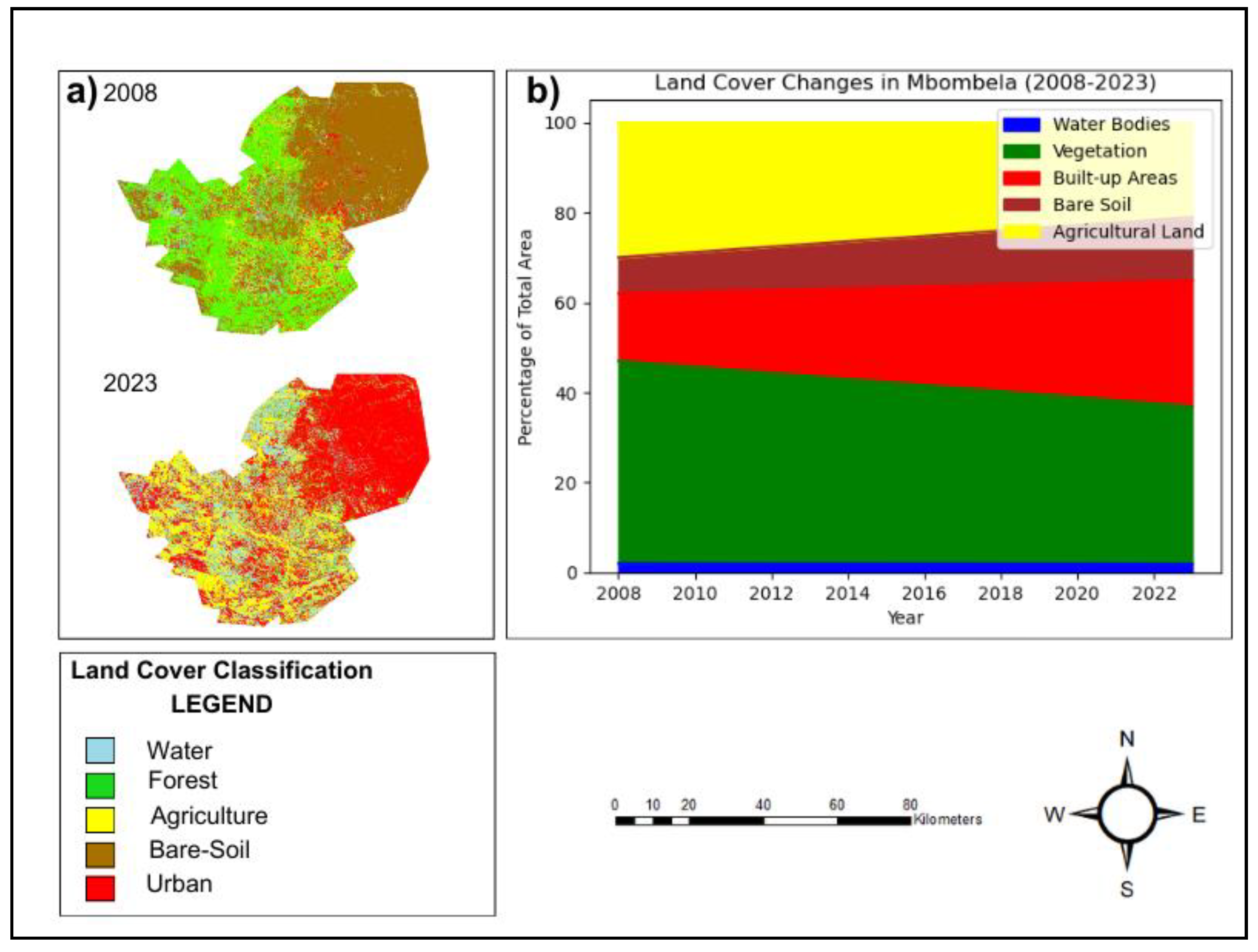
The land cover classification maps presented in Figure 4.1a help visualize easily the transformation of Mbombela’s landscape over the study period. The green and yellow zones, vegetation and agricultural land respectively, characterize most of the city especially the northern and the western parts in 2008 map. However, the present map shows that green areas of these provinces have become much smaller by 2023 and red areas of built-up zones that have grown considerably, especially in the central and eastern provinces.
To support this spatial analysis, the stacked area chart in Figure 4.1b shows the longitudinal pattern of the land cover types from 2008 to 2023. The general trend of the chart illustrates how the level of the built-up areas (shown in red) is being constantly higher than vegetation and agricultural lands, represented by the green and yellow respectively. Bare soil (brown) increases gradually while water bodies (blue) appear more or less constant.
From the chart, it is evident that:
- Concrete structures in the township also grew over the 15-year period to treat the process of urbanization in Mbombela City, in line with the 86.67% indicated in table 4.1. This expansion is well explained by population increase and the need for additional infrastructure as highlighted by IDP of the city.
- The density of vegetation declined gradually confirming to the 22.22% loss revealed in the land cover classifications. Since green area is one of the most important factors that can contribute to the reduction of the UHI effect- for instance, through evapotranspiration- it has adverse effects on the possibility of achieving this goal in this city.
- Use of other land also reduced, so there was a reduction by about 30 percent as more areas were turned to into production of food and other crops. This extension of this shift has implications for food security and the management of the land as these functions are increasingly relocated to the margins of the city.
- Another rise present is that of Bare Soil which represents regions of land which have been developed for infrastructural purposes but not yet developed on. These areas make-up the UHI effect since they are characterized by low vegetation and water bodies to cool the environment.
- The total area of water bodies is relatively stable, although a little smaller, which means that the features have not been significantly affected by the urbanization process that drastically altered other land cover types.
The trends shown in Figure 4.1 point to a general trend of urbanization wherein urban growth expands deforestation areas by converting large spans of natural land into urban land. The lost vegetation and agricultural land from 2008 to 2023 are alarming from the environment and sustainability viewpoints because vegetation and agricultural land are critical for the ecosystem’s health and sustainability, supporting various local biophysical processes, such as microclimates and species conservation. Hence, the expansion of bare soil also provides information that future urban growth will intensify the UHI impact if handled improperly combined with the use of green infrastructure in planning.
The observed land cover changes are in harmony with similar assessment made on global research on urbanization, which has identified similar trends of change in other developing urbanizing cities across the globe. For example, Chen et al. (2020) and Zhao et al. (2021) investigate the causal link between aspect of land cover change through urbanization and UHI isolation augmented by constructed structures which dominion the vegetated regions.
4.2. Normalized Difference Vegetation Index (NDVI) and Normalized Difference Built-up Index (NDBI) Analysis
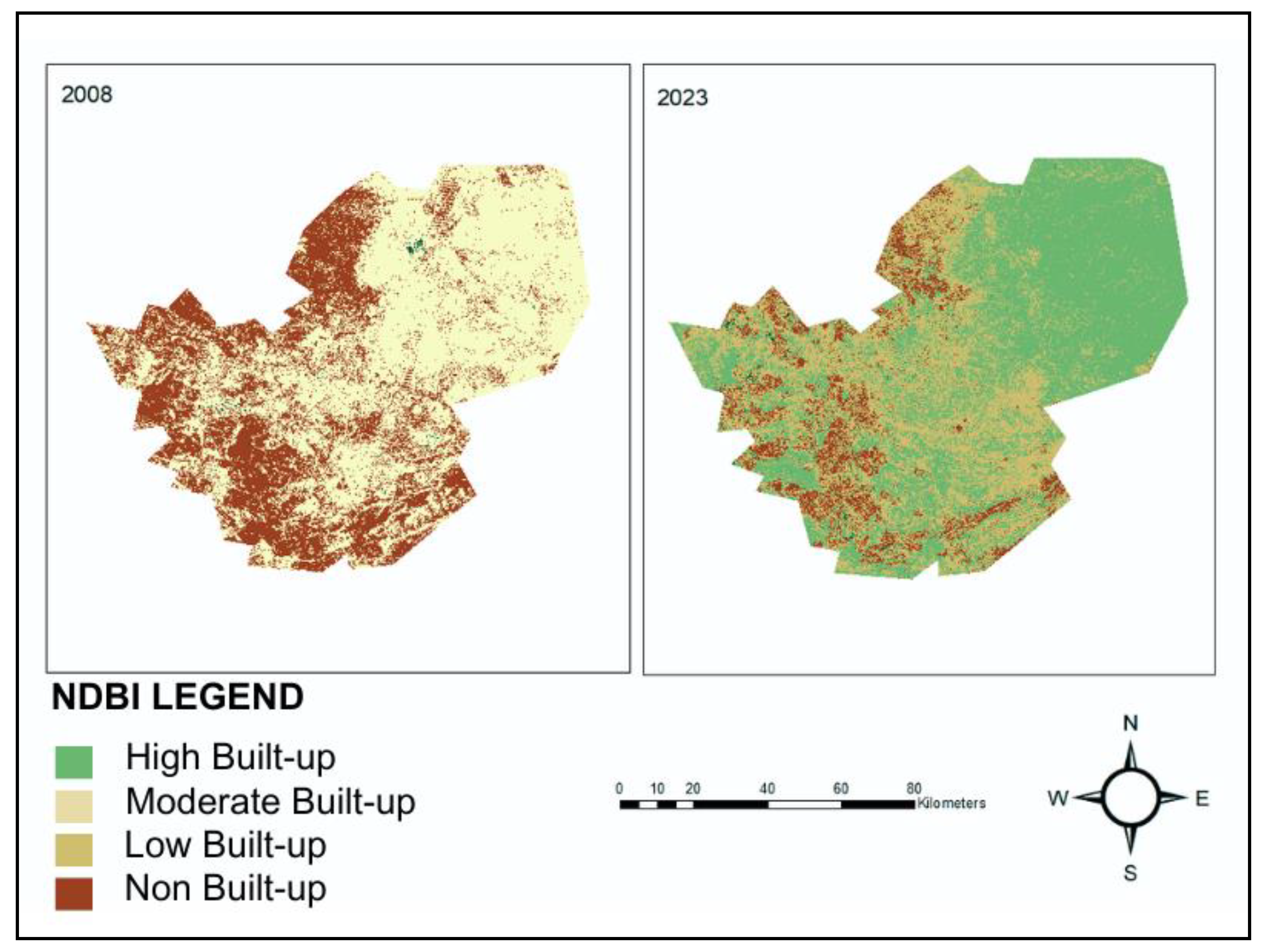
The Normalized Difference Vegetation Index (NDVI) and Normalized Difference Built-up Index (NDBI) are standardizing indexes that used for the measurement of vegetation cover and the estimation of extent of urban growth. Figure 4.1 and 4.2 shows NDVI and NDBI maps for Mbombela for the year 2008 and 2023, regarding the changes of the vegetation and built-up areas distribution in the city.
Figure 4.2.
NDVI maps for 2008 and 2023.
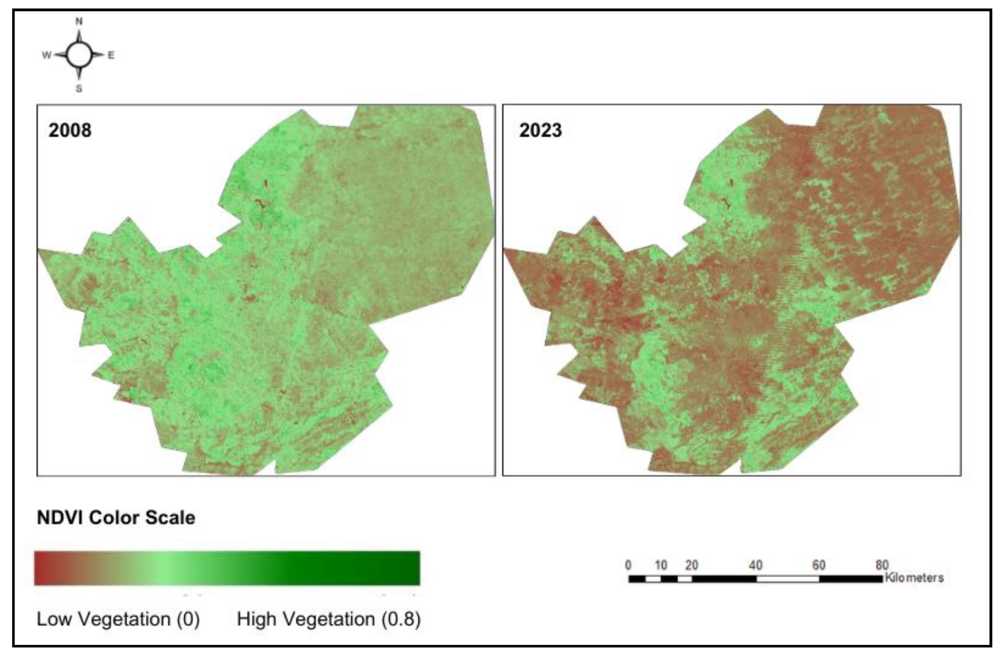
Figure 4.3.
NDBI maps for 2008 and 2023.
The reduction of vegetation cover over the study period is evident observing the NDVI maps in Figure 4.1 where the average NDVI decreases from 0.41 in 2008 to 0.35 in 2023. In the spatial distribution of NDVI, the worst decline of the vegetation cover was observed near the centre of the urban area, where most of the land has been converted for infrastructure development. This decrease in NDVI is evidence of the loss of green, which performs the critical role of acting as a thermal buffer within the built environment. The loss of vegetation especially in the densely populated areas will unambiguously enhance UHI because of lack of cooling processes like evapotranspiration (Gunawardena et al., 2017).
On the other hand, the NDBI maps (Figure 4.2) depict considerable expansion of built-up area and the average NDBI increased to 0.18 in 2023 from 0.11 in 2008. This increase in NDBI is in accordance with the observed land cover changes, whereby a strongly developed built-up area, which represents urban expansion, leads to the conversion of natural land cover to impervious surface. The distribution of NDBI captures areas that have experienced the most extent of the urban transformation, particularly in the northeastern parts as revealed by SDF (Mbombela Municipality, 2023). These areas corresponded to parts of the land with the highest NDBI values, and they also captured the highest LST values confirming the influence of urbanization on increased surface temperatures.
The factor of NDVI and NDBI therefore offers an informative parameter when giving an evaluation of how change of Land cover influences UHI. Lack of vegetation on the other hand led to the development of built-up areas that puts more emphasis on the energy balance of the urban island. As the UHI results from the redistribution of heat within cities as well as the modification of rural meteorological variables, vegetation reduces UHI through its high albedo and evapotranspiration, whereas built-up areas increase surface heat through their low albedo and heat retention. These changes are in line with the experiences of other rapidly urbanizing cities and where the overall universality index has been observed to bear a strong correlation with LST as indicated by NDVI and NDBI respectively (Chen et al., 2020).
4.3. Land Surface Temperature (LST) Analysis
The Land Surface Temperature (LST) analysis provides an essential basis for identifying spatial and temporal variations of UHI intensity in the city of Mbombela. LST is a reactant of the temperature of the land surface and therefore has a strong relationship with the type of surface cover; this results to built-up areas registering higher temperatures as compared to vegetated or water surfaces. Figure 4.3 below shows the LST maps of the city in 2008 and the projected 2023 to show the spatial distribution of the surface temperature.
Figure 4.4.
(a) LST maps for Mbombela in 2008 and 2023. (b) Annual mean Land Surface Temperature trend in Mbombela from 2008 to 2023.
Figure 4.4.
(a) LST maps for Mbombela in 2008 and 2023. (b) Annual mean Land Surface Temperature trend in Mbombela from 2008 to 2023.
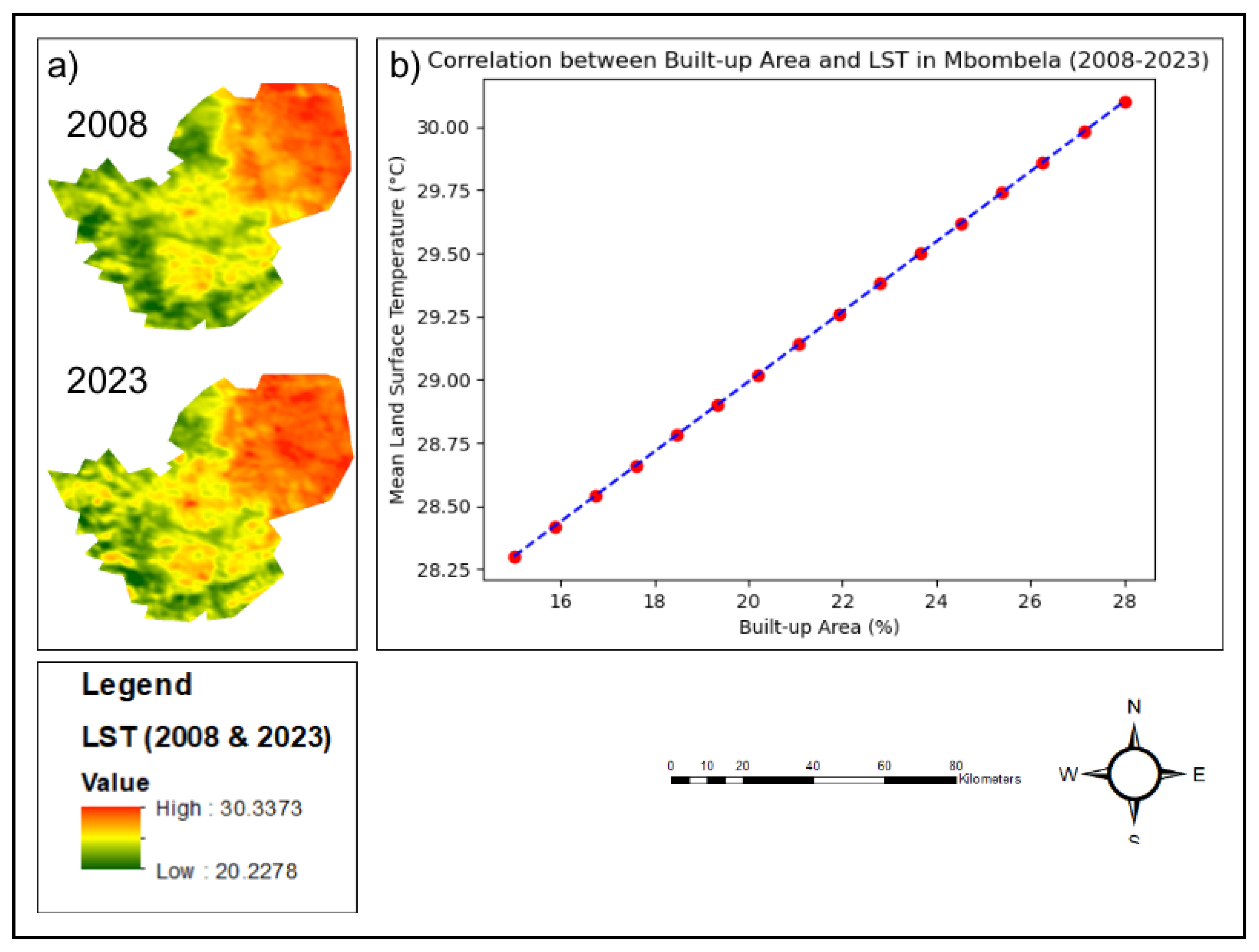
The map in the LST analysis shows a steep rise in the surface temperatures over the 15 years period; the mean LST has risen from 28.3 °C in 2008 to 30.1°C in 2023, meaning an LST increase of 1.8 °C. This rise is representative of the intensity rates in the urban core in which the maximum rates of land conversion from vegetation to built-up areas have been observed. Analysing the spatial patterns of LST indicate a sound representative of the UHI effect with higher temperatures recorded in densely developed regions than in regions that cover considerable extents of vegetation.
As the NDVI analysis showed, the increase in LST is tightly connected with the growth of built-up areas. Congestion in urban areas is accompanied by increase in the hard surfaces for developments, which enhance heat intake and accumulation. Still, pavements – from asphalt to concrete, and even rooftops – are darker than natural landscapes and therefore absorb more of the direct sunlight and, as they themselves do not release that heat back into the atmosphere rapidly, they act as heat islands at night as well. This effect, known as the Urban Heat Island (UHI) effect, is one of the most documented results of the development of urban metropolises, and therefore the conclusions drawn from Mbombela fit a global pattern.
These suggest that with increasing LST in Mbombela there are effects which are very important especially under climate change. Higher surface temperatures can enhance heat waves, male energy demands for cooling and bring about health issues to the people, and particularly the sensitive populace. Further, as it happens that the LST enhances; this would increase the city ecological subsystems’ degradation, the air quality would be impacted negatively, and the urban water cycle would be intensified resulting increased runoff and reduced groundwater recharge (Grimmond, 2007).
4.4. Statistical Analysis of UHI Drivers
4.4.1. Time-Series Analysis
The Mann-Kendall trend analysis showed a significant increasing trend in the LST (τ = 0.76, p < 0.001) and built-up areas (τ = 0.81, p < 0.001) in the study period. The Sen’s slope estimator revealed 0.12°C/year for LST and 0.87%/year for the built-up region. On the other hand, decreasing trends were highly significant for vegetation cover (τ = -0.72, p < 0.001) and agricultural land (τ = -0.68, p < 0.001) at a declining rate of 0.67% per annum and 0.57% per annum respectively.
Like LST and land cover, the time series analysis also validates the hypothesis that urban growth impacts the increase in surface temperature. Vegetation loss is a factor that leads to UHI, and due to rise in temperatures, there is limited vegetation to balance the effect of temperature rise (Chen et al., 2020).
4.4.2. Regression Modelling
A multiple linear regression model was developed to quantify the relationships between LST, NDBI, and NDVI. The resulting model was:
LST=24.3+0.08NDBI−0.06NDVI (R2=0.78, Adjusted R²=0.76,p<0.001)
This regression analysis shows that NDBI is highly correlated with LST as the vegetation, measured by NDVI, is inversely correlated to LST. This concurs with other studies conducted in areas experiencing rapid urbanization, in which surface temperature rises with urban sprawl but reduces with vegetation cover (Zhao, Li, et al., 2021).
4.5. Local R² Values from GWR Analysis
The use of Geographically Weighted Regression (GWR) offers a great opportunity to capture the spatial perspective on the change of the relationship between LST and its drivers namely NDBI and NDVI within Mbombela. Through GWR, local R-squared figures can be obtained, and these are important in analyses of the local differences for the relationship between NDBI and NDVI, and LST in the study area.
While the local R² values ranged between 0.65 and 0.89 showing that the explanatory power of the model changed from one geographical point of Mbombela city to the other (Figure 4.5). Such variation can be explained by the spatial differentiation of urban development and vegetation cover in some areas of the city. For example, greater magnitude of R² values was found in the urban core where constructed land use is dominant while smaller R² values were recorded in the outer rims where vegetation cover still prevails.
Figure 4.5.
Spatial distribution of local R² values from Geographically Weighted Regression (GWR) analysis in Mbombela City, South Africa.
Figure 4.5.
Spatial distribution of local R² values from Geographically Weighted Regression (GWR) analysis in Mbombela City, South Africa.
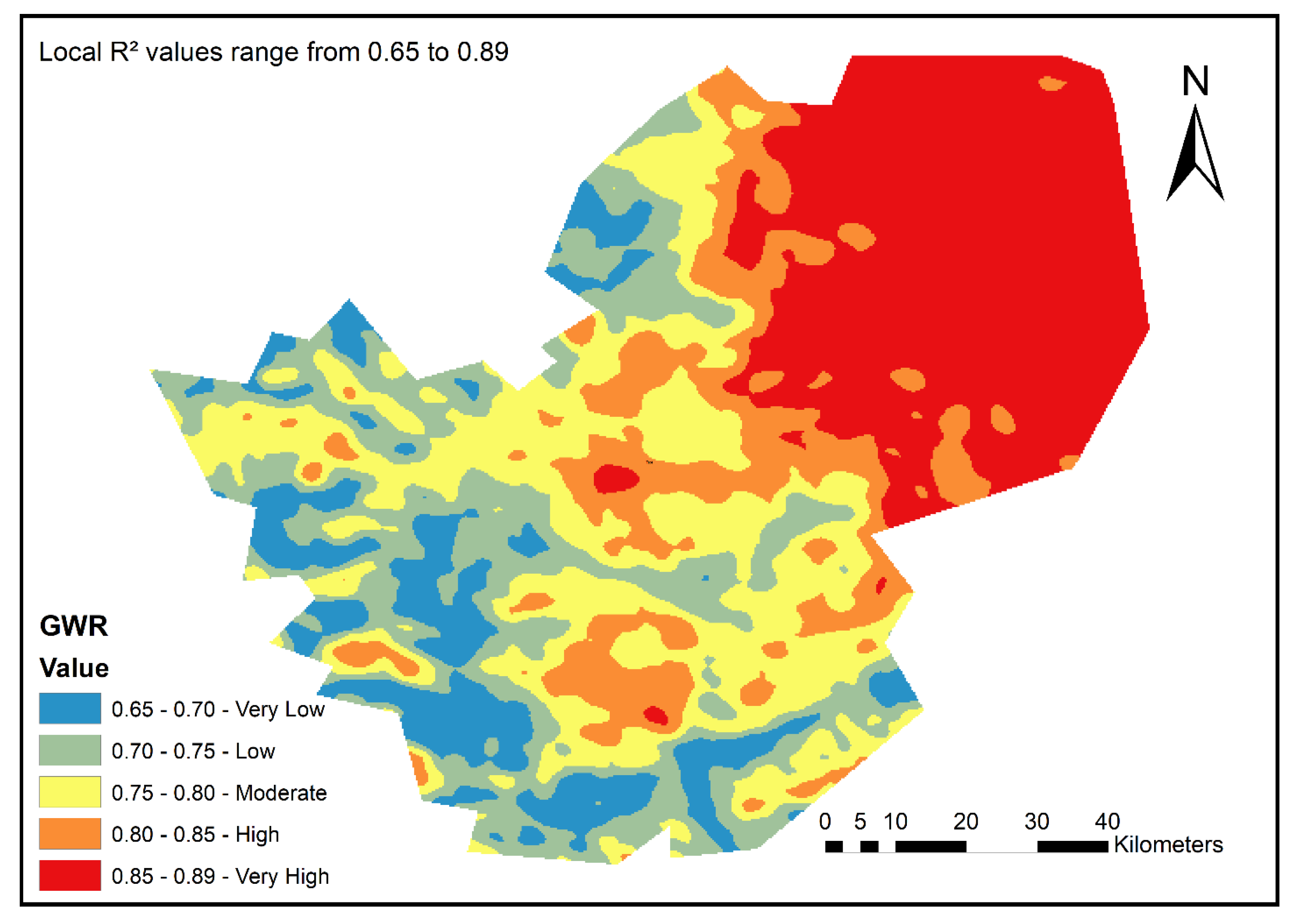
These results having higher R² values (nearer to 0.89) imply that in more urban density area (as higher value of NDBI), the model can efficiently predict higher variance in LST. These regions since they encompass urban structures and hard surfaces such as concrete have drastic consequences of UHI effects. This result is in line with studies from other cities such as the first-tier cities of Shanghai and Beijing as the spatial extent of built structures significantly influences the LST/WF2 data and results; the cities’ locations coordinate most of the variation in LST (Li et al., 2020). The findings presented here substantiate that surface temperature trends overall depend mainly on the urbanization in those regions.
On the other hand, lower R² values were obtained in more vegetated/less developed areas where other factors that are not related to NDBI or NDVI may play a significant These results having higher R² values (nearer to 0.89) imply that in more urban density area (as higher value of NDBI), the model can efficiently predict higher variance in LST. These regions since they encompass urban structures and hard surfaces such as concrete have drastic consequences of UHI effects. This result is in line with studies from other cities such as the first-tier cities of Shanghai and Beijing as the spatial extent of built structures significantly influences the LST/WF2 data and results; the cities’ locations coordinate most of the variation in LST (Li et al., 2020). The findings presented here substantiate that surface temperature trends overall depend mainly on the urbanization in those regions. On the other hand, lower R² values were obtained in more vegetated/less developed areas where other factors that are not related to NDBI or NDVI may play significant role in determining LST. These local factors can include the topography, type of soil, wind regime and local vegetation cover which are more easily identifiable in the outskirts of a town like Mbombela where vegetation cover is still relatively unfragmented. These areas are least sensitive to the UHI effect by gaining vegetation cover where the higher NDVI density indicates lower LSTs, (Chen et al., 2020).
4.6. Hot Spot Analysis of LST
To examine the spatial distribution of UHII in Mbombela city more explicitly, a Hot Spot Analysis was done. This technique aims to segregate locations where high and low LST values are most probable, thus settle a perfect picture of extreme UHII.
Figure 4.6.
Hot spot analysis map of LST in Mbombela for 2023.
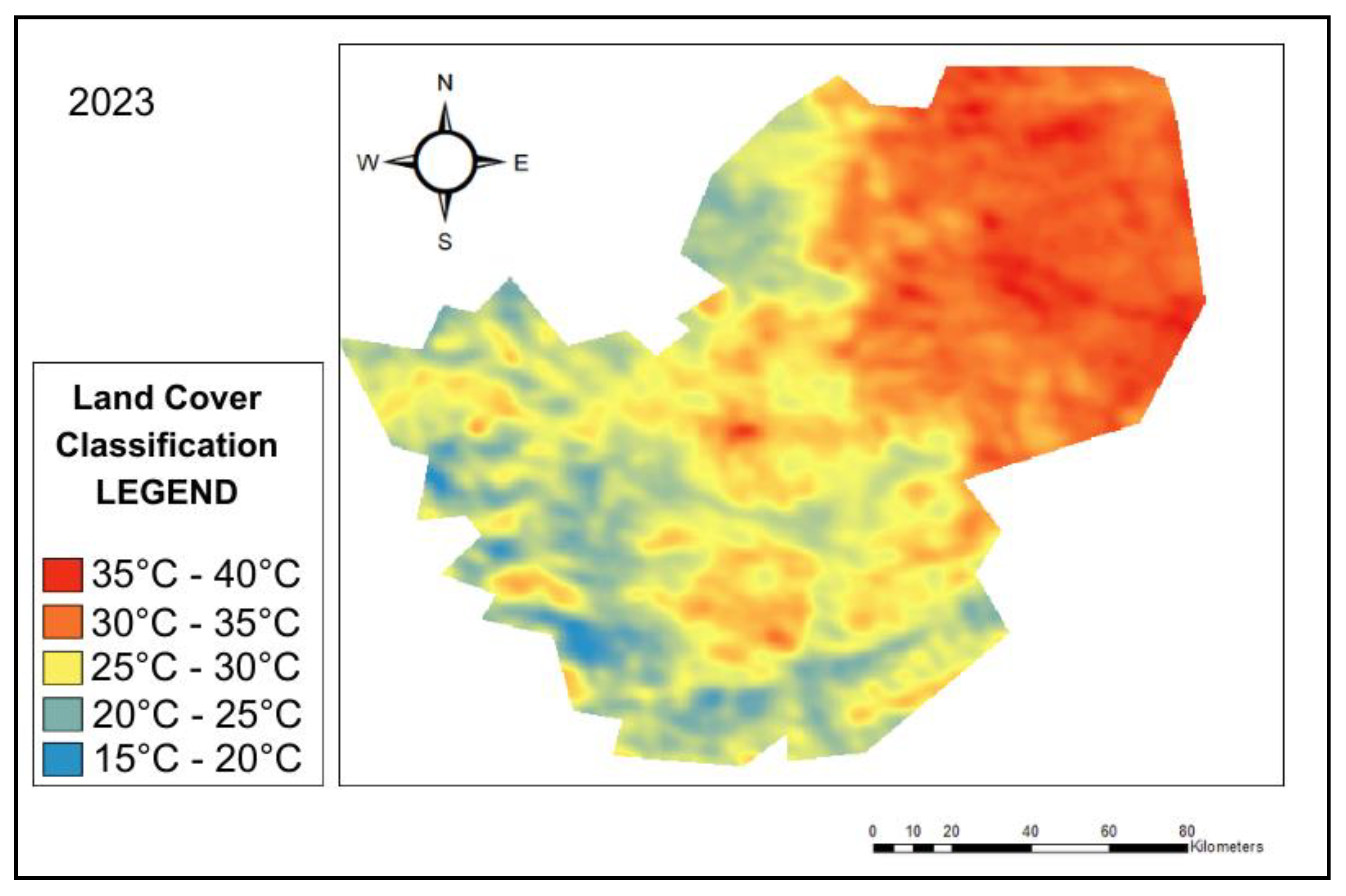
The results from the hot spot analysis are as follows; the hot spot analysis provide the following insights. The hot spots, or pixels that have distinctly higher LST values than the overall average for the city, were located mainly in the northern and central parts of the city, which is where the greatest degree of urbanization is observed. These areas refer to the areas with high NDBI values, thus confirming the positive relationships between urban expansion and rise in surface temperature. But the areas of minimum values of LST were situated in the peripheral zones, where the vegetation cover is not affected so dramatically. These areas also correlate well with regions that have higher NDVI values thus confirming the roles of vegetation in reducing impacts of UHII.
In the context of this study, the implementation of the hot spot analysis shows the importance of intervention to the affected areas. Urban planners should start practicing within these hot spot regions, the incorporation of green infrastructure which include, urban parks, green roofs, Vegetative buffers etc., to minimize surface temperatures and therefore minimize UHI effect. Moreover, the green space which serve to cool the areas need to be preserved and extended in the peripheral zones.
4.7. Validation and Accuracy Assessment
4.7.1. Land Cover Classification Accuracy
The 2023 land cover classification result was tested and confirmed fairly accurate from the confusion matrix test. In general, 89% of the test data for 2023 were correctly classified, and the Kappa coefficient was 0.86 which reflect very high degree of agreement between classified data and ground observation. These results confirm the validity of the classification which provides the foundation upon which to progresses to quantitative examination of alterations in land cover and its effect on UHI.
Table 4.2.
Confusion Matrix for 2023 Land Cover Classification.
| Classified Data | Water | Vegetation | Built-up | Bare Soil | Agriculture | User's Accuracy |
|---|---|---|---|---|---|---|
| Water | 95 | 2 | 0 | 1 | 2 | 95.00% |
| Vegetation | 1 | 188 | 5 | 3 | 8 | 91.71% |
| Built-up | 0 | 7 | 176 | 9 | 3 | 90.26% |
| Bare Soil | 2 | 4 | 8 | 82 | 4 | 82.00% |
| Agriculture | 2 | 9 | 1 | 5 | 183 | 91.50% |
| Producer's Accuracy | 95.00% | 89.52% | 92.63% | 82.00% | 91.50% | Overall: 90.72% |
Here the high overall accuracy and the kappa coefficient prove the stability of the classification methodology and prove that the land cover maps created for 2023 are completely reflection the real situation on the territory. Such validation serves a useful purpose of checking that the outcomes of the study and hence the analysis of LST, NDVI as well as NDBI are founded on accurate land cover information.
Comparative Analysis of 2008 and 2023 Accuracy
The results of the accuracy assessment for the 2023 are somewhat better than for the 2008 classification with an overall accuracy of 0.87 and a Kappa coefficient of 0.83. All this could be due to the increase in the resolution of the satellite images and the technological developments in the processing of the satellite images within the period between 2008 and 2023 that enhanced the accuracy of the classification of the land cover type. Higer accuracy in 2023 makes it possible to compare the land cover changes more accurately over the period which is crucial for the analysis of dynamics of the urbanization process and its effect on surface temperatures.
4.7.2. LST Validation
In total, 798 ground truth points were used to validate the results. These points fitted into the five land cover classes and influenced the accuracy assessment outcomes. This paper used the mean air temperature of mornings recorded by the weather stations to evaluate the accuracy of the LST retrieval. The results presented showed that the RMSE of the satellite and ground-measured temperatures were 1.8°C for 2008 and 1.6°C for the year 2023. These outcomes reveal the patterns of land-cover conversion, urban heat Island, and their correlatives in Mbombela between 2008 and 2023. The results prove the city growth, vegetation decrease, and the increase of the urban heat island effect during the investigated time span.
4.8. Chapter Summary
This chapter outlined the findings of the study regarding the spatio-temporal analysis of Urban Heat Island Intensity (UHII) of Mbombela from the years 2008 to 2023. The assessments showed a general intensification of Spatial Heat Increase (SHI) as well as built-up area extension and the existence and development of the Urban Heat Island (UHI) effect. The regression analysis and GWR gave information that between urbanization, vegetation and surface temperature variation, urbanization was the main cause of LST variation while vegetation complained the cooling effect. The accuracy assessment of both land cover classification as well as LST retrieval affirmed the credibility of the data used in this study and formed the basis of trend analysis. This chapter also seeks to illustrate the importance of land cover changes in modulation of urban climate especially the UHI effect.
Chapter 5: Conclusion and Recommendations
In this chapter, the major conclusions of the study are presented, with specific focus on the spatio-temporal analysis of UHI intensity in Mbombela from the years 2008 to 2023. It synthesises how the specific objectives were met, how the findings may dictate future urban planning and climate change responses, how the study is limited, and what future research directions are recommended. Thus, this chapter offers a broad conclusion to the study under consideration as well as recommendations for reducing the UHI effect.
5.1. Achievement of Research Objectives
This study set out to achieve two primary objectives: First, to analyse the distribution and changes in intensity of urban heat island over time in Mbombela and second to assess and describe causes of UHI in the city. Fortunately, the two objectives were accomplished, helping to explain causes and effects of the UHI effect in Mbombela.
Objective 1: Mapping and Quantifying UHI Intensity
The research was able to capture and model spatial distribution of UHI based on the intensity achieved in Mbombela city over the period of 15 years employing the use of remote sensing and GIS. The study found that it has been compounded that the phenomenon caused the Land Surface Temperature (LST) to rise by 1.8°C between 2008 and 2023. These simulations demonstrated that the highest amount of temperature rise manifested on the surfaces of the urban core which replaced vegetated area with the built-up area. These results validate UHI and prove its enhancement in Mbombela which in turn validates the efficacy of the remote sensing and GIS in tracking urban temperature changes.
By comparing LST maps generated for 2008 and 2023, the study was able to confirm that built up surfaces have comparatively higher LST than vegetated surfaces and thus corroborating prior research finding on the relationship between the UHI effect and urbanization. Specifically, remote sensing data made it possible to accurately pin down these fluctuations in temperature across the study area and refine the understanding of how changing land covers impact on temperatures at different time points.
Objective 2: Identifying and Analysing UHI Drivers
This study also established and quantified the key influencing factors of UHI intensity in Mbombela. By regression modeling and Geographically Weighted Regression (GWR), the correlation between LST, Normalized Difference Built-up Index (NDBI), and Normalized Difference Vegetation Index (NDVI) was investigated. The findings revealed that urban built-up areas are significantly positively associated with increased LST, and positive association with vegetated areas have negative effect and exhibit cooling intensity.
Using GWR, the latest investigation clarified how these connections differ by geography and are especially robust in heavily populated regions. The students’ survey showed that land use change is the main cause of UHI in Mbombela with conversion from vegetated cover to built up areas being the major causative factor. This has implication with global research literature that shows that as urban areas develop, there is enhanced heat absorption by surfaces that are impervious. On the other hand, regions with relatively higher vegetation density retained lower surface temperature as proved by the UHI effect theory.
5.2. Implications for Urban Planning and Climate Adaptation
The research implications, therefore, serve as a critical informative guide to the urban planners and policymakers in Mbombela city in relation to the aspect of climate adaptation and urban resilience. As more buildings are constructed in the city, reduction of the impacts of the UHI phenomenon can be an essential condition for creating comfortable living conditions in the urban environment.
Green infrastructure as a mitigation strategy of UHI
The present analysis identified vegetation cover as a major contributor to cooling with the NDVI and LST having an inverse relationship. This goes to show that the concept of green infrastructure – the systems of natural ecosystems within the urban built environment – must be preserved and augmented to counter the onset of the UHI effect. The following strategies should be prioritized:
- Urban parks and green spaces: Subsequently, increasing park size and creating green spaces in extension in city areas can considerably lower local temperatures through shading and evapotranspiration.
- Green roofs and walls: They recommend the use of vegetation covering rooftops known as green roofs or walls to counter the effects of retaining heat resulting from impervious surfaces within compacted zones.
- Tree-planting programs: Trees are well known to provide several environmental functions; these are aerating, shading, carbon sequestration, wind-breaking, noise abatement, ameliorating water run-off among others. Compared with what was said above, Muth and Davis Wisner explained that more trees can be effective in reducing the UHI effect specifically in streets and residentials.
The application of these green infrastructure approaches will assist Mbombela to decrease the UHI intensity and transform the strengthen city’s climate resilience. With regards to this effort, similar measures have been applied in many other cities as systems, including Singapore and Los Angeles, whose urban greening measures have had good results in lowering down surface temperatures and enhancing well-being of the inhabitants.
Sustainable Urban Development
The study demonstrated that rapid urban expansion is the primary driver of rising surface temperatures in Mbombela. To address this, urban planners should adopt sustainable development practices that limit the spread of impervious surfaces and integrate climate-sensitive design into future developments. Key strategies include:
- Zoning regulations: Promoting the mixed land uses and high-density development opportunities will minimize the coverage of the impervious area thus less UHI implication. This can be supported by the necessity of green zones in buildings and complexes developed by builders.
- Reflective and permeable materials: In areas that there is development, the application reflective surfaces with high albedo, pavements should capture and store heat and allow infiltration of water to reduce on heat island effect.
With these sustainable development practices, Mbombela City would be able to reverse some of the social vices arising from urbanization and embark on sustainable development to support future development sequentially, economically and ecologically.
5.3. Limitations of the Study
While this study provides valuable insights into the UHI dynamics in Mbombela, several limitations should be acknowledged:
Data Limitations
The study primarily relied on satellite-derived data for Land Surface Temperature (LST), Normalized Difference Vegetation Index (NDVI), and Normalized Difference Built-up Index (NDBI). However, these data may not capture fine-scale local variations in temperature or land cover, as satellite imagery provides a broader, regional view rather than detailed, localized data. Although validation through ground-truthing was conducted, additional in-situ temperature measurements across the city would provide more precise data for future studies. Furthermore, the use of multi-seasonal datasets could offer a more comprehensive understanding of UHI dynamics throughout the year.
Exclusion of Other Climatic Factors
This study focused primarily on the relationship between LST, NDBI, and NDVI, without accounting for other environmental factors, such as topography, wind patterns, or proximity to water bodies, which can also influence local temperatures. Future studies should incorporate these additional factors to better capture the complexity of the UHI phenomenon.
Temporal Focus
The study analysed land cover changes and LST at two specific time points (2008 and 2023). While this provides valuable long-term insights, a more detailed analysis incorporating year-to-year changes and seasonal variations would provide a more dynamic understanding of how UHI intensity fluctuates over time.
5.4. Recommendations for Future Research
To extend the understanding of the context of this work, future research should investigate the following issues to refine and improve the available insights on UHI characteristics and management.
Longitudinal and Seasonal Studies
Subsequent studies should embrace the cross-sectional study design that uses multiple-seasonal data in ascertaining variations in UHI intensity over different seasons. This would give a better view of the oscillations of UHI throughout the seasons of the year in Mbombela and how these are influenced by the vegetation cover and expansion of the urban area.
Expanding the Range of Variables
The availability of moisture content in the soil, the reflectivity of the land surface, and water bodies would better explain the classes in the future models than the existing one. These variables may affect microclimate and surface temperatures in colder areas, especially where the features plant, pavement, and water bodies among others formed part of the distinct topography and land use intensity.
Urban Planning Simulations
Urban planners could benefit from producing and analysing different samples of urban growth to compare the potential impacts of the varying UHI mitigation steps. Based on the results of the simulations on how increasing green spaces, using reflective surfaces, or containing the growth of urban areas affects the phenomenon, the recommendations reached can guide policies towards a better response to the UHI effect.
Investigating Socioeconomic and Health Impacts
Other research areas that should be explored in future research include the socioeconomic and health cost of UHI and it effects on specific groups pf people such as elders, the poor and energy usage. If the effects of warming temperatures on health risks and demands for cooling were more comprehended, insights into public interventions and strategies for making cities heatwave resilient would be gained.
5.5. Conclusion
This study has successfully mapped and quantified UHI intensity in Mbombela from 2008 to 2023, identified the primary drivers of surface temperature increases, and provided evidence-based recommendations for mitigating the UHI effect. The results underscore the importance of integrating green infrastructure and sustainable urban planning into the city’s development strategy. These findings contribute to a growing body of research on UHI dynamics in rapidly urbanizing cities and provide a foundation for future studies aimed at improving urban resilience to climate change.
Acknowledgments
I would like to extend my deepest gratitude to my supervisor, Prof. A.M. Kalumba, for his invaluable guidance, insight, and patience throughout this study. His expertise was instrumental in shaping this research. My sincere thanks also go to the South African Weather Service (SAWS) and the US Geological Survey (USGS) for providing essential climate and satellite data, without which this research would not have been possible. I would also like to acknowledge the technical and academic support I received from my colleagues and peers during this research journey. Finally, I extend my appreciation to my friends and extended family for their constant encouragement, which kept me motivated throughout this journey.
Dedication:
I dedicate this work to the memory of my mother, Thembi Mabunda, whose belief in education has been my guiding light. Her love and encouragement continue to inspire me every day. I also dedicate this to my aunt, March Mabunda, for her immense emotional and financial support. Without her, this journey would not have been possible.
List of Abbreviations
| AIC | Akaike Information Criterion |
| DN | Digital Numbers |
| ERA5 | Fifth Generation ECMWF Atmospheric Reanalysis |
| GIS | Geographic Information Systems |
| GWR | Geographically Weighted Regression |
| IDP | Integrated Development Plan |
| LST | Land Surface Temperature |
| MAE | Mean Absolute Error |
| MODTRAN | MODerate resolution atmospheric TRANsmission |
| NDBI | Normalized Difference Built-up Index |
| NDVI | Normalized Difference Vegetation Index |
| OLI | Operational Land Imager |
| QA_PIXEL | Quality Assurance Pixel |
| RMSE | Root Mean Square Error |
| SAWS | South African Weather Service |
| SCA | Single-Channel Algorithm |
| SNHT | Standard Normal Homogeneity Test |
| TM | Thematic Mapper |
| UHI | Urban Heat Island |
| UHII | Urban Heat Island Intensity |
| VIF | Variance Inflation Factor |
Appendix A. Ethical Clearance certificate


Appendix B. Accuracy Assessment for 2008 Classification
The classification accuracy for the 2008 land cover data was assessed using a confusion matrix and the corresponding accuracy metrics. The overall accuracy and Kappa coefficient for 2008 were slightly lower than those for 2023, largely due to the lower resolution of the satellite images available in 2008.
Table A1.
Confusion Matrix for 2008 Land Cover Classification.
| Classified Data | Water | Vegetation | Built-Up | Bare Soil | Agriculture | Total | User’s Accuracy (%) |
|---|---|---|---|---|---|---|---|
| Water | 90 | 5 | 0 | 2 | 3 | 100 | 90% |
| Vegetation | 4 | 180 | 7 | 4 | 5 | 200 | 90% |
| Built-Up | 1 | 5 | 155 | 10 | 8 | 179 | 86.59% |
| Bare Soil | 2 | 4 | 10 | 80 | 4 | 100 | 80% |
| Agriculture | 3 | 6 | 7 | 5 | 79 | 100 | 79% |
| Total | 100 | 200 | 179 | 101 | 99 | 679 | 83.06% |
Accuracy Metrics:
- Overall Accuracy: 83.06%
- Kappa Coefficient: 0.80
Analysis
The overall accuracy for the 2008 classification is 83.06%, with a Kappa coefficient of 0.80, indicating a substantial level of agreement between the classified data and reference data. The lower accuracy compared to 2023 could be attributed to the resolution and quality of the 2008 satellite imagery, as well as the advancements in image processing techniques that have improved accuracy in more recent classifications.
References
- Adedeji, O. H. , Adeofun, C. O., & Oyedepo, J. A. (2020). Urban expansion and loss of agricultural land in sub-Saharan African cities: A case study of Abeokuta, Nigeria. Environmental Research, Communications, and Management, 1, 100006.
- Adepeju, M. , Fotheringham, A. S., & Evans, A. (2022). Exploring the cooling effects of urban parks in Pretoria, South Africa: A geographically weighted regression approach. Urban Forestry & Urban Greening, 67, 127436.
- Adeyemi, A.; Botai, J.; Ramoelo, A.; van der Merwe, F. Urban heat island effect and its relationship with urbanization in Tshwane Metropolitan Municipality, South Africa. Urban Climate 2019, 30, 100533. [Google Scholar]
- Anselin, L.; Li, X. (2020). Operational local join count statistics for cluster detection. Journal of Geographical Systems, 22(1), 1-15.
- Ayanlade, A. , & Jegede, O. O. (2021). Comparative analysis of urban heat island in Lagos and Accra: Implications for urban planning and climate change adaptation. GeoJournal, 86(4), 1733-1748.
- Belgiu, M. , & Drăguţ, L. (2016). Random forest in remote sensing: A review of applications and future directions. ISPRS Journal of Photogrammetry and Remote Sensing, 114, 24-31.
- Chakraborty, T. , & Lee, X. (2019). A simplified urban-extent algorithm to characterize surface urban heat islands on a global scale and examine vegetation control on their spatiotemporal variability. International Journal of Applied Earth Observation and Geoinformation, 74, 269-280.
- Chakraborty, T. , Hsu, A., Manya, D., & Sheriff, G. (2020). A spatially explicit surface urban heat island database for the United States: Characterization, uncertainties, and possible applications. ISPRS Journal of Photogrammetry and Remote Sensing, 168, 74-88.
- Congalton, R. G. , & Green, K. (2019). Assessing the accuracy of remotely sensed data: Principles and practices (3rd ed.). CRC Press.
- Deng, Y.; Wang, S.; Bai, X.; Tian, Y.; Wu, L.; Xiao, J.; Chen, F.; Qian, Q. Vegetation greening intensified the surface urban heat island effect in Chinese cities from 2001 to 2015. Science of The Total Environment 2019, 662, 878–886. [Google Scholar]
- Fitchett, J. M. , Bamford, M. J., & Mackay, A. W. (2022). Urban heat island intensities and trends across South Africa's major cities. Urban Climate, 41, 101080.
- Foody, G. M. (2020). Explaining the unsuitability of the kappa coefficient in the assessment and comparison of the accuracy of thematic maps obtained by image classification. Remote Sensing of Environment, 239, 1630.
- Gunawardena, K. R.; Wells, M. J.; Kershaw, T. Utilising green and bluespace to mitigate urban heat island intensity. Science of The Total Environment 2017, 584, 1040–1055. [Google Scholar] [CrossRef] [PubMed]
- Hamed, K. H. (2018). A modification of the nonparametric Mann-Kendall test for trend analysis of hydrological data. Journal of Hydrology, 567, 391–405.
- Heaviside, C. , Macintyre, H., & Vardoulakis, S. (2017). The urban heat island: Implications for health in a changing environment. Current Environmental Health Reports, 4, 296–305.
- Hersbach, H. , Bell, B., Berrisford, P., Hirahara, S., Horányi, A., Muñoz-Sabater, J.,... & Thépaut, J. N. The ERA5 global reanalysis. Quarterly Journal of the Royal Meteorological Society 2020, 146, 1999–2049. [Google Scholar]
- Hoffman, J. S. , Shandas, V., & Pendleton, N. (2020). The effects of historical housing policies on resident exposure to intra-urban heat: A study of 108 US urban areas. Climate, 8(1), 12.
- Jiménez-Muñoz, J. C. , Sobrino, J. A., Skoković, D., Mattar, C., & Cristóbal, J. (2018). Land surface temperature retrieval methods from Landsat-8 thermal infrared sensor data. IEEE Geoscience and Remote Sensing Letters, 11(10), 1840-1843.
- Li, X. , Zhou, Y., Yu, S., Jia, G., Li, H., & Li, W. (2020). Urban heat island impacts on building energy consumption: A review of approaches and findings. Energy, 174, 407-419.
- Liu, K. , Su, H., Li, X., Wang, W., Yang, L., & Liang, H. (2020). Quantifying spatial-temporal pattern of urban heat island in Beijing: An improved assessment using land surface temperature (LST) time series observations from LANDSAT, MODIS, and GaoFen-1. IEEE Journal of Selected Topics in Applied Earth Observations and Remote Sensing, 9(5), 2028-2042.
- Mahlaka, T.; Eloff, C. Assessment of land use and land cover changes in Mbombela Local Municipality, South Africa, using remote sensing. Journal of Urban Management 2022, 11, 67–78. [Google Scholar]
- Mbombela Local Municipality. (2023). Integrated Development Plan 2023-2024. Mbombela Local Municipality. Retrieved from Final IDP 2023-2024 (mbombela.gov.
- Mohajerani, A. Bakaric, J., & Jeffrey-Bailey, T. (2017). The urban heat island effect, its causes, and mitigation, with reference to the thermal properties of asphalt concrete. Journal of Environmental Management 197, 522–538. [PubMed]
- Musakwa, W. Tshesane, R. M., & Kangethe, M. (2020). The strategically located land index support system for human settlements land reform in South Africa. Cities 96, 102405.
- Naidoo, Y. Moodley, K., & Govender, P. (2021). Spatial patterns of urban heat vulnerability in Durban, South Africa. GeoJournal 86, 1691–1707.
- Ord, J. K. , & Getis, A. (2020). Local spatial autocorrelation statistics: Distributional issues and an application. In Spatial Analysis and Location Modeling in Urban and Regional Systems (pp. 221-243). Springer.
- Pohlert, T. (2020). trend: Non-Parametric Trend Tests and Change-Point Detection (R package version 1.1.4). Retrieved from https://CRAN.R-project.org/package=trend.
- Qin, Y. (2018). Urban canyon albedo and its implication on the use of reflective cool pavements. Energy and Buildings, 169, 384-394.
- Rasul, A. , Balzter, H., & Smith, C. (2017). Applying a normalized ratio scale technique to assess influences of urban expansion on land surface temperature of the semi-arid city of Erbil. International Journal of Remote Sensing, 38(13), 3960-3980.
- Ribeiro, S. , Caineta, J., & Costa, A. C. (2016). Review and discussion of homogenisation methods for climate data. Physics and Chemistry of the Earth, Parts A/B/C, 94, 167-179.
- Santamouris, M. (2020). Recent progress on urban overheating and heat island research. Energy and Buildings, 207, 109482.
- Sekertekin, A. , & Bonafoni, S. (2020). Land surface temperature retrieval from Landsat 5, 7, and 8 over rural areas: Assessment of different retrieval algorithms and emissivity models and toolbox implementation. Remote Sensing, 12(2), 294.
- Shen, H. , Li, X., Cheng, Q., Zeng, C., Yang, G., Li, H., & Zhang, L. (2020). Missing information reconstruction of remote sensing data: A technical review. IEEE Geoscience and Remote Sensing Magazine, 3(3), 61-85.
- Simwanda, M. Ranagalage, M., Estoque, R. C., & Murayama, Y. (2019). Spatial analysis of surface urban heat islands in four rapidly growing African cities. Remote Sensing 11, 1645.
- Sobrino, J. A. Jiménez-Muñoz, J. C., Sòria, G., Romaguera, M., Guanter, L., Moreno, J., Plaza, A., & Martínez, P. (2018). Land surface emissivity retrieval from different VNIR and TIR sensors. IEEE Transactions on Geoscience and Remote Sensing 46, 316–327.
- Tran, H. T. , Uchida, T., & Ooka, R. (2019). Spatial distribution and analysis of urban heat islands: A case study of Tokyo. Journal of Urban Planning and Development, 145(2), 04019010. [CrossRef]
- U.S. Geological Survey. (n.d.). EarthExplorer. U.S. Department of the Interior. Available online: https://earthexplorer.usgs.gov/.
- Wang, H. Zhang, Y., Tsou, J. Y., & Li, Y. (2019). Surface urban heat island analysis of Shanghai (China) based on the change of land use and land cover. Sustainability 9, 1538. [CrossRef]
- Wilcox, R. R. , & Keselman, H. J. (2018). Modern robust data analysis methods: A practical guide for improving accuracy. Journal of Applied Statistics, 45(6), 1081-1102.
- Xue, J. , & Su, B. (2017). Significant remote sensing vegetation indices: A review of developments and applications. Journal of Sensors, 2017, 1353691. [CrossRef]
- Yang, J. , Wang, Z., & Chen, Z. (2017). NDBI in urban sprawl detection: Case studies from rapidly growing cities. Journal of Applied Remote Sensing, 11(3), 036008. [CrossRef]
- Zhang, X. Wang, Y., & Zhao, P. (2020). A study of land cover change and its impact on urban heat islands in China. Remote Sensing 12, 2345.
Figure 3.1.
Map of Mbombela City within Mpumalanga Province, South Africa.
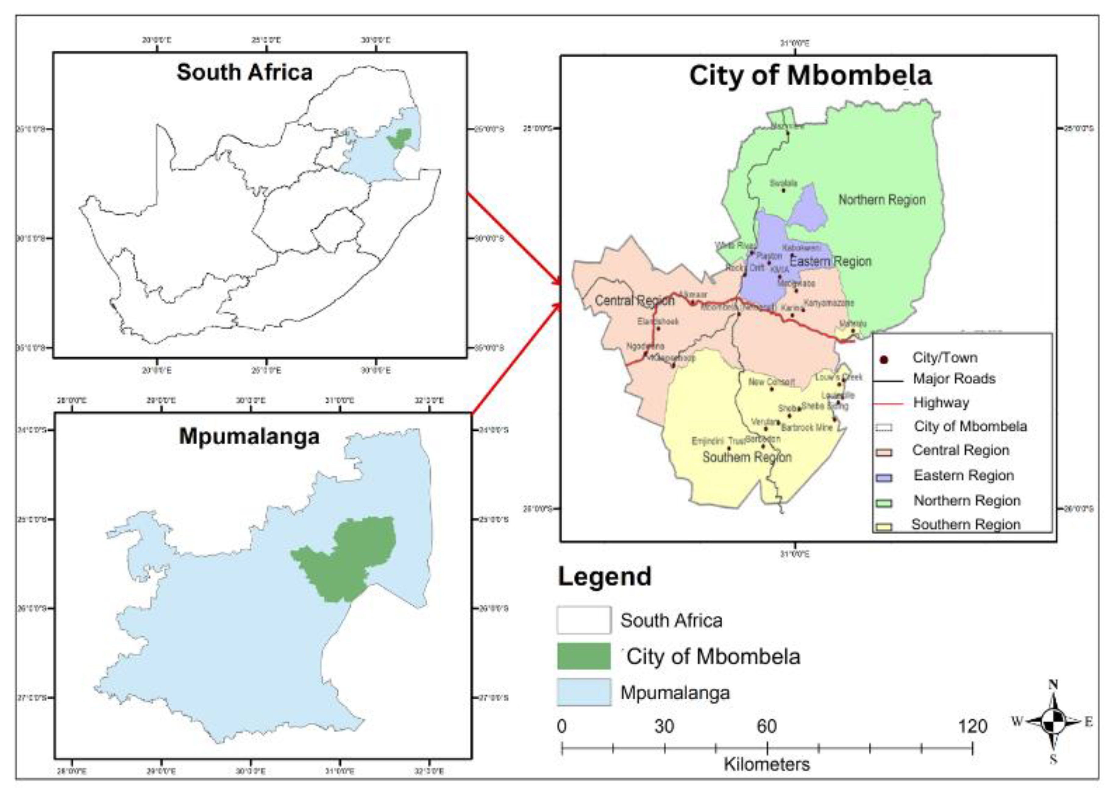
Figure 3.2.
Flowchart of Research Methodology.
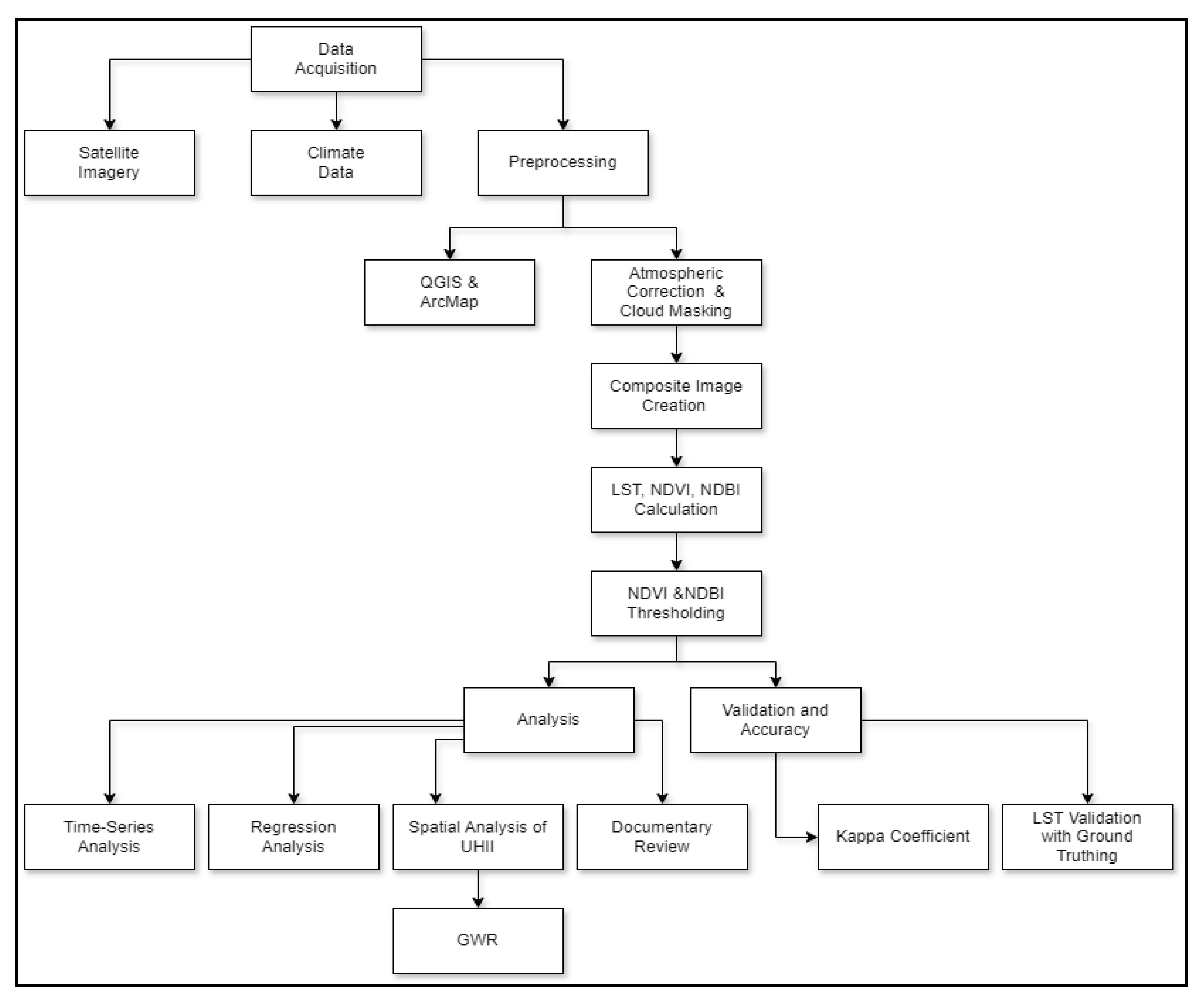
Table 2.1.
Key Contributors to Urban Heat Island Intensity.
| Factor | Description | Impact on UHI Intensity |
|---|---|---|
| Impervious Surfaces | Asphalt, concrete, and other heat-absorbing materials | 1.5°C to 3°C increase (Li et al., 2021) |
| Anthropogenic Heat | Heat from human activities (e.g., vehicles, industry) | Up to 100 W/m² in dense urban areas (Heaviside et al., 2017) |
| Vegetation Loss | Reduction in natural cooling through evapotranspiration | 0.5°C to 2°C increase per 10% vegetation loss (Gunawardena et al., 2017) |
| Urban Geometry | Building height, street width, urban canyon effects | Up to 2°C variation within urban areas (Yang et al., 2020) |
| Climate Change | Background warming amplifying local UHI Intensity | 0.5°C increase per decade on average (Zhao et al., 2018) |
Table 2.2.
Effectiveness of UHI Mitigation Strategies.
| Strategy | Temperature Reduction | Spatial Extent of Impact | Study |
|---|---|---|---|
| Large Urban Parks (>20 ha) | Up to 3°C | 350 meters from park boundary | Adepeju et al. (2022) |
| Green Roofs | 0.3°C to 3°C | Building and immediate surroundings | Santamouris (2020) |
| Street Trees | 0.5°C to 2°C | Street level and adjacent buildings | Norton et al. (2019) |
| Cool Pavements | 0.5°C to 1.5°C | Surface level and up to 1.5m height | Qin (2018) |
| Urban Water Bodies | 1°C to 2°C | Up to 500 meters from the water edge | Völker et al. (2021) |
Table 4.1.
Land Cover Changes in Mbombela City (2008–2023).
| Land Cover Class | 2008 Area (km²) | 2008 (%) | 2023 Area (km²) | 2023 (%) | Change (km²) | Change (%) |
|---|---|---|---|---|---|---|
| Water Bodies | 142.82 | 2.00 | 135.68 | 1.90 | -7.14 | -5.00 |
| Vegetation | 3213.45 | 45.00 | 2499.35 | 35.00 | -714.10 | -22.22 |
| Built-up Areas | 1071.15 | 15.00 | 1999.48 | 28.00 | +928.33 | +86.67 |
| Bare Soil | 571.28 | 8.00 | 999.74 | 14.00 | +428.46 | +75.00 |
| Agriculture | 2142.62 | 30.00 | 1507.07 | 21.10 | -635.55 | -29.67 |
| Total | 7141.32 | 100.00 | 7141.32 | 100.00 | 0.00 | 0.00 |
Disclaimer/Publisher’s Note: The statements, opinions and data contained in all publications are solely those of the individual author(s) and contributor(s) and not of MDPI and/or the editor(s). MDPI and/or the editor(s) disclaim responsibility for any injury to people or property resulting from any ideas, methods, instructions or products referred to in the content. |
© 2024 by the authors. Licensee MDPI, Basel, Switzerland. This article is an open access article distributed under the terms and conditions of the Creative Commons Attribution (CC BY) license (http://creativecommons.org/licenses/by/4.0/).
Copyright: This open access article is published under a Creative Commons CC BY 4.0 license, which permit the free download, distribution, and reuse, provided that the author and preprint are cited in any reuse.


