

Submitted:
12 September 2024
Posted:
14 September 2024
You are already at the latest version
Abstract
The agricultural soil maps (ASMs) showing the agricultural land of Poland were prepared in 1:5000 scale in 1960s’ and 1970s’. These maps show land suitability group, soil type and soil texture (ST) to a depth of about 150cm. Nowadays, these maps are being digitalized and might be a basis for the preparation of modern soil maps at local, regional, national and international level. The agreement between the ST of topsoil derived from ASMs and recently evaluated for eleven fields located in three voivodeships (regions) of Poland was studied. The study of soil considered the examination of soil profiles or augerings and laboratory analysis of the ST. The agreement between soil status in the field and according to maps was field-specific. Complete agreement (purity) within the field was assessed for 5-79% of ST classes and for 23-100% of agronomic categories (ACs) – a groupings of similar ST classes. However, the averaged agreement, which treated adjacent ST classes as having partial agreement, varied from 37 to 88% for ST classes and from 61 to 100% for the ACs among studied fields. These results indicate on the variable quality of the information shown on the ASMs and on the necessity of improvement of these maps.
Keywords:
agricultural soil maps
; soil texture class
; agronomic category
; purity
; averaged agreement
1. Introduction
Due to the environmental and ecological role of soil, it maintains its importance on each level, from the local to global, and this implies on the need to possess reliable soil maps. As example, at the global level, soil maps are necessary for the preparation of various models e.g earth surface fluxes, soil hydrologic properties, pedotransfer models [1], and at the local level soil maps are needed for the proper implementation of precision agriculture techniques, particularly for variable application of agricultural inputs to increase their efficiency [2].
Polish agricultural soil maps (ASMs) were prepared in the 1960s and 1970s on the basis of soil quality maps (1:5000) and additional terrain studies at 1:5000 and 1:25000 [3] as the support for farms in land management, planning, and soil conservation [4] . According to Kabała et al. [5] ASMs will probably be one of the basic sources for the preparation of new and reinterpreted soil maps in medium and small scales.
Soil texture (ST) is one of the most important properties shown on soil maps. This property is relatively stable in time [6], affects major part of other soil properties, and is important for field management. ST (granulometric) groups or soil species according to the Polish Society of Soil Sciences (PSSS, Polish acronym PTG) classification [7], Figure 1 and Table A1, referred further as PTG 1956, were used to show ST on the ASMs comprising about 90% of the area of agricultural land of Poland. While other soil species, in particular rendzinas, alluvial, diluvial and developed from loess soils were shown on maps for the remaining 10% of the area of agricultural land according to digitalized agricultural soil map at 1:25000 scale [8]. In 1978, a new, professional standard [9] was introduced which modified the PTG 1956 classification, by further division of some of the ST classes. This professional standard was a base for merging similar ST classes into soil agronomic categories (AC, Figure 1 and Table A1), which since 1986 have been used for formulating fertilizer recommendations [10,11] and with the development of precision agriculture techniques could be used for site-specific soil management. The ACs are not shown on the ASMs, but may be relatively simply derived from these maps. These days, when digitalized ASMs are available at low cost for the whole area of the agricultural land of Poland, they can be used as a supplementary source of information on soil quality (mainly drainage capability strongly related to ST), which is essential for crop rotation planning. The fertilizer recommendations should be based on the recent results of nutrient availability. However, these recommendations can be more precisely formulated because the information on the AC can be derived from the ASMs.
Thus, a question arises, to what extent does the content of the ASMs done in the 1960s and 1970s reflect the current or at least recent soil status of particular fields? Actually, not many studies explored the agreement of the ASMs with the recent soil status of the agricultural land in Poland. Koćmit and Podlasiński [12] and Podlasiński [13] studied moraine areas with intensive relief in north-western Poland and concluded that the ASMs from the years 1966-1974 did not reflect the current soil quality status of these areas, due to map generalization and changes of soil cover due to erosion. Stępień et al. [14] examined the topsoil texture of 4 fields in Poland and observed very variable agreement – from 0 to 100% – between the ST indicated on the ASMs and the recent ST status of these fields. Also, on a global scale, not many studies were done that compared ST derived from soil maps and recently determined by a laboratory or field method. In Brazil, Van den Berg and Oliveira [15] assessed the quality of soil maps of 33 fields (395 study sites) and they reported very high map quality regarding ST in the layers of 0-20 cm, and 60-80 cm, obtaining 80-95% of purity (the portion of points or the area with the correct prediction of a given attribute by the map). In Croatia, Hengl and Husnyak [16] evaluated six of a total of 186 sheets of soil maps of this country done on a 1:50000 scale. The contents of sand, silt, and clay were evaluated in 10 soil profiles with 21 samples, and obtained normalized RMSE of 60-64% depending on the soil separate. This indicated low accuracy of this soil attribute as the value of the normalized RMSE should be lower than 40%. Radočaj et al. [17] validated the accuracy of ST shown on the SoilGrids2.0 with the resolution of 250 m, using ground truth data from 686 soil samples taken from the layer of 0-30 cm. Relatively good accuracy of the SoilGrids was obtained for clay content (normalized RMSE of 36%) and very poor for silt (normalized RMSE of 46%) and sand (normalized RMSE of 255%) contents, and, in general it was assessed as low. Richer-de-Forges et al. [18] evaluated various digital soil maps (DSM) for central France, to locally predict ST using hand feel ST determination performed for 3263 soil observation points. As a measure of the soil map accuracy, the authors used the shortest distance between the predicted laboratory ST and the observed hand feel ST class. For topsoil texture, this distance was the shortest for regional soil map (0.21) and much longer (0.32) for SoilGrids2.0. As a consequence, the authors questioned the local use of global or continental DSM products. In Namibia [19] assessed various DSM products, including SoilGrids2.0 with the highest resolution (250 m) in terms of topsoil texture prediction quality using, in total 1102 field locations as reference. The authors obtained overall accuracy of 0.27 (27% of purity) for SoilGrids2.0 and up to 0.42 for WISE30sec [20] and concluded that all soil maps were inaccurate. Maynard et al. [21] evaluated the prediction accuracy of various soil maps (DSM products) of Ghana using three datasets of different sizes (from 75 to 6514 study sites) versus results of field-estimated ST. The overall accuracy (corresponding to purity) of the maps on ST class according to the USDA classification, varied from 9 to 35% depending on the soil map and the dataset used. Overall accuracy adjacent, including also adjacent ST classes to the correctly predicted was higher, between 39 and 90%. The authors concluded that“...these map products are not accurate enough to inform site-specific soil management”. In the other works on the evaluation of the quality of soil maps the topsoil texture was evaluated together with other soil properties. For example, in Mexico, Lleverino González [22] evaluated the quality of the Land Classification Map (Spanish: mapa de Clases de Tierras) as very high, with purity of 76%. In central Iowa (USA) Brevik et al. [23] tested the accuracy of a soil map done at a scale of 1:15840 for a 25 ha field and obtained the map purity of 60-70% in the identification of two main soil delineations of four shown on the map, although it was lower in some delineations. Despite this good result in comparison to the national standard of map purity of 50%, the map quality was assessed as not adequate for precision agriculture purposes [23].
The aim of the present study is a quantitative comparison of the information on topsoil texture shown on Polish ASMs done at a scale of 1:5000 with recent ST status determined in a laboratory for eleven fields of a total area of 369 ha.
2. Materials and Methods
This study explores data obtained during agronomic studies carried out in the year 2009-2015. This study comprised 11 fields located in 3 regions (voivodeships) of Poland (Figure 2, Table 1). In general, in one field, between 5 to 12 soil profiles were dug to a depth of about 1m and additionally, between 16 to 52 samples were collected from the plough layer. The placement of the soil sampling points was arbitrarily designed so that the number of soil samples from one map delineation was proportional to the area of this delineation. Thus, the larger areas delineated on the map were represented by a higher number of soil samples than smaller areas.
The geographical coordinates of the soil sampling points were recorded using Topcon GRS-1 and GR-3, GNSS receivers (Livermore, California, United States).
In total, 439 topsoil samples were collected, air-dried, sieved using a 2 mm mesh size and analysed using the sieve-hydrometric method of Casagrande modified by Prószyński. The results were then recalculated to obtain the content of fine earth separates according to the former – PTG 1956 – ST classification, which was used to create the ASMs and in which only the particles of a diameter smaller than 1.0 mm were treated as fine earth [24,25].
The agreement between ST classes shown on the ASMs and ACs derived from these maps was assessed in the soil sampling points. The agreement between ST class shown on the ASM and determined in this study was evaluated according to Stępień et al. [14], as good (value 1), medium (value 0.5), and poor (value 0.0). This agreement was considered good (1.0), if the ST class determined in a laboratory was exactly the same, as shown on the ASM. The agreement was assessed as medium (0.5), if the ST class determined in our study belonged to a similar ST class, i.e. adjacent to a respective group shown on the ASM (Table 2 and Figure 3).
The division of similar ST classes into the ACs [10,11] distinguished 4 categories (1. Very light, 2. Light, 3. Medium and 4. Heavy, Table A1 and Figure 1), which could be most frequently, directly derived from the ASMs. The unique exception was ordinary silt (płz), which in ST classification [9] from 1978, was divided into 3 groups of silts: płp (sandy silt), “new” płz which were then classified into the category of light soils, and płg (loamy silt) which was classified as medium soil (see on Figure 1). As a result, the “old” płz shown on the ASMs could be classified as light or medium. For this reason and for the purposes of this paper the AC of 2/3. Light/medium (silty) soils was distinguished (Table A1 and Table 3 and Figure 1). As a result, this “old” płz has a medium agreement (0.5) with 7 ST classes, and, when regarding ACs, it has good agreement with two of them, (2 and 3), and medium agreement with the remaining 2 categories (1 and 4), as it is shown in Table 3 and Figure 3.
For an explanation of the abbreviations coding all ST classes, the content of soil separates, and attribution to the agronomic categories (ACs) see Table A1 and Figure 1.
The agreement between the ST class derived from the ASM and determined by a laboratory method in this study for the particular soil sampling points was calculated using two measures: purity/overall class accuracy and averaged agreement (AA).
The purity of soil map was defined by Bie and Beckett [26] as the “percentage of random sites at which map would have predicted the class to which the soil belongs” and this definition actually corresponds to overall class accuracy [21] i.e. “the proportion of observation points at which the map predicts the correct soil property class”. In this paper, soil map purity (Pur.) was calculated according to the following formula:
Pur. (%) = nG 100/(nG + nM + nP)
where nG, nM and nP is a number of points in the field (or other set of records, as a ST class or AC) with good, medium and poor agreement in the map (i.e. all points considered in the considered field, ST class or AC).
The averaged agreement (AA) was calculated according to the following formula:
AA (%) = (nG 1.0 + nM 0.5) 100/(nG + nM + nP)
This formula is actually the same as provided by Stępień et al. in 2015 [14], although written in different way.The purity and AA were calculated regarding ST classes shown the ASMs and ACs derived from these maps for each field separately and also for data merged for all fields.
Additionally, example maps of three fields were prepared using QGIS (3.22.4-Białowieża) open software. These maps include: field boundaries, the location of soil sampling points, and approximated areas of disagreement of the ACs derived from the ASM and based on a ST laboratory analysis done for this study (delineated arbitrarily for areas with no fewer than two neighbouring points of disagreement), which were superimposed on scans of the original ASMs done on a 1:5000 scale.
3. Results
3.1. Expectations – the Soil Texture Classes and Agronomic Categories According to the Maps (ASMs) and their Representativeness
Table 4 presents the number of soil samples in ST classes shown on the agricultural soil maps of fields considered in this study and approximated area of these delineations on the basis of digital agricultural soil maps done on a 1:25000 scale. The most represented delineation of ST class (according to the map) was pgm (111 samples, almost 150 ha of 5 fields, located in one region), then gl (64 samples, 117 ha, 3 fields, located in two regions), glp (59 samples, 57 ha, 4 fields located in one region) and pgl of 45 samples, 55 ha, 5 fields, located in two regions. Less represented were the delineations of ST class such as płz (34 samples, 21 ha from 2 fields, and 1 region), gsp (33 samples, 16 ha from 2 fields, and 1 region), ip (28 samples, 2 fields, and one region), płi (26 samples, 2 fields, and one region) and gcp (13 samples, one field). According to the ASMs very small representation of ps, pgmp, pglp and psp (4-7 samples, 0.5-7.0 ha from 1-2 fields and regions) was found. Additionally, 5 samples were collected from very small areas delineated as organic soils (Emt or T) and wastelands (N). In this study there was no representation of pl, plp (very light soils), gs, gc and i (heavy soils, Table A1) of ST classes.
In terms of the ACs, which might be derived from the ASMs, the light soils were most represented (165 samples, collected from 215 ha of nine fields, and two regions), medium soils (123 samples, 174 ha from 6 fields, and two regions) and heavy soils (100 samples, 57 ha, 4 fields, and two regions). Much smaller was the representation of an intermediate category of light/medium (silty) soil, płz (34 samples, 2 fields, one region), and the very light soils (ps and psp, 11 samples and 6 ha from 3 fields, and 2 regions).
3.3. Reality – Agreement of the Recent Topsoil Texture Classes of the Fields with the Topsoil Texture According to the Agricultural Soil Maps
The comparison of the presence of particular ST classes in the fields according to our recent studies and the ASMs is shown in Table 5. When the whole fields are considered, the purity of delineation of ST classes varied between 5 and 79%, and the AA was between 36 and 88% – with the highest values obtained for only one field PB (Table 5). On the other hand, very low purity of the ASM in comparison to the recent ST status was obtained for fields PD2 (5%), MI1 (9.1%) and MI2 (9.8%), and the map purity of the remaining fields was between 10 and 50%. AA of ST classes according to the ASMs and recent ST status on the fields was higher, and it exceeded 50% not only for PB field, but also for the other 5 fields: PD1, PD2, PD2, LSG, and LSC.
If the particular delineations within the fields are considered, the agreement between ST shown on the ASMs and recent ST status was more variable, as both the purity and the AA varied between 0 and 100% even within one field (Table 5). The null purity (0%) of the ASMs was found in 13 delineations of 8 fields, and perfect purity (100%) in one delineation of one field.
In this paper, examples of the ASMs of three fields will be discussed in more detail. In the field PB (Table 6, Figure 4), with apparently the best agreement of the ST class obtained from the ASM and a recent laboratory analysis , two ST classes were shown on the map. The smaller delineation of pgmp (located in the north-western corner of the field) showed 0% of the map purity, but 50% of the AA, as all topsoil samples belonged to a similar gl soil texture class. The delineation of gl (light loam, see Table A1), shown on the map for most of the field, had the purity of 87% and the AA of 92%, but some samples from this delineation (close to the middle of the southern part of the field) belonged to other ST classes, such as pgm, pgl, pgmp and gs. In other words, the PB field is actually loamy (gl) both according to the ASM and recent ST evaluation, but some sandy areas (pgl and pgmp) were present in other places than indicated on the original ASM.
The field PPW was characterized by map purity of 31% and the AA of 44.2% between the map and the recent ST status (Table 5, Figure 5). However, the most extensive delineations of pgl on the ASM (south-eastern part) of this field had very poor agreement between the map and recent soil status – purity of 0% and the AA of 8% – as actually gl prevailed in this area (11 samples out of 13). Smaller delineation of pgm showed much better agreement between the map and recent ST evaluation – 29% of purity and 64% of the AA, although it was also mainly loamy (gl) for 5 samples out of 7). The last and slightly smaller delineation of gl according to the map was also gl according to this study (6 samples), and it resulted in a perfect evaluation of both purity and the AA. In other words, according to the ASM the significant part of this field should be predominantly sandy (pgl and pgm, 20 samples out of 26), but according to the recent study it is loamy, as sandy loam (gl) predominates on this field (21 samples out of 26).
The field MI2 had very poor purity of agricultural soil map (9.8%, Table 5) and the lowest AA (36%) among all tested fields. The ASM showed four delineations of different topsoil textures and one delineation of wasteland (N, Table 6 and Figure 6). The wasteland showed 0% of purity and 0% AA of the ASM in comparison with the recent ST evaluation, as it is currently included into cropped area. However, other two delineations of topsoil (płz and psp) showed also 0% of purity and poor AA (12.5 and 29.2%, respectively). The most extensive delineation (10 ha with 17 samples taken) of silty clay (ip) also showed low purity (6%) and the AA of 38%. However, small delineation of pgl (about 4 ha) showed relatively good agreement between the map and the recent study – 43% of purity and 64% of the AA.
Consequently, it can be concluded that on the fields with generally good agreement of ST derived from the ASM and recent topsoil texture evaluation, the areas of poor agreement are found, while on the fields with overall poor agreement between the map and recent evaluation, the areas of good agreement may be observed.
3.4. Reality – Agreement of the Topsoil Agronomic Categories of the Fields Between Agricultural Soil Map and Recent Studies
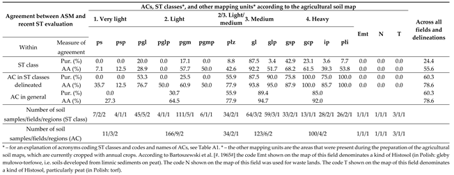
Generally, agreements between ACs derived from the ASMs and from the recent soil ST evaluation (Table 7) of all the study fields are considerably higher than respective agreements for ST classes. For the whole fields, the map purities varied between 23 and 100%, and exceeded 50% in the case of 8 fields. The average agreement between ASMs and recent soil status exceeded 50% for all fields considered in this study.
As for ST classes, the respective agreements for ACs were considerably lower for some particular delineations within fields than for whole fields (Table 6). The map purity of these delineations regarding ACs varied between 0 and 100%, but, in general, it was higher than for ST classes. The null (0%) purity of the agronomic categories was observed in 7 delineations for 5 fields, but it exceeded 50% in 11 delineations for 8 fields. Even though, in some fields (PG, PPW, MI2, MO, and LSG) delineations with the agreements of ACs derived from the ASMs and recent ST studies varying between 0 and 100%, are found. However, some of these null agreements refer to small areas close to the field boundaries, which were delineated as organic soils (Emt or T) or wastelands (N, Figure 5) and currently are treated as arable land.
If we consider the same three examples of the fields, as described in the previous section, the consideration of the AC (Table 6) instead of ST class (Table 5), the general agreement of ASM with recent evaluations did not change considerably for field PB (Figure 4).Only for the most precisely mapped delineations of sandy loam (gl), the AA slightly increased to 94%. In the field PPW (Figure 5 and Table 5 and Table 6), the overall purity of the map and AA with recent evaluation increased to 39 and 69%, respectively. Surprisingly, the field MI2 (Figure 6), which was characterized by the poorer agreement of the ASM with the recent reality in terms of ST classes than field PPW, but was better assessed in terms of the ACs (63 and 76% of purity and AA, respectively).
3.3. Agreement of the Topsoil Agronomic Categories of the Fields Between Agricultural Soil Map and Recent Studies
The overall purity of ASMs of all fields considered in this study in comparison with recent soil status on the field was about 24%, regarding ST classes and 60% for the ACs (Table 7 and A2). The average agreement was higher and amounted to almost 56% and 79% for ST classes and ACs, respectively.
If the delineations of the same ST class from the maps of all fields included in this study are considered, a high variability of values of agreement between ASM and recent ST status could be noted, as the purity varied between 0 and 88%, and the AA ranged from 0 to 92%. The lowest values of map agreement with recent reality were observed most frequently for delineations poorly represented, such as pglp (4 samples from one field) 0% of purity and the AA), ps (7 samples from 2 fields and 2 regions, 0% of purity and 7% of AA), psp (4 samples from one field and region, purity 0% and AA 13%) and pgmp (6 samples from one field and region, purity 0%, but AA 50%). Other delineations with poor purity (<10%) and AA (<50%) were relatively well represented, namely pgl (45 samples), płz (34) and ip (28). The assessment of agreement of glp (59 samples) and płi (26 samples) delineations of ASM with recent soil status on the field are quite ambiguous, as both delineations were characterized by very poor map purity (<1)%) and much better AA ((56% and 54% respectively). The best represented delineation of ST class in this study - pgm (111 samples from 5 fields and 1 region) had still relatively low map purity of 17%, and not very high AA of 58%. In contrast, poorly represented gcp delineation (13 samples from 1 field) had higher map purity of 23%, and the AA of 62%. Relatively well represented delineation of similar soil texture class – gcp (33 samples) from two fields and one region) had the purity of 43% and AA – 68%. The unique delineation with very good agreement between the ASM and recent ST status was gl (64 samples from 3 fields, and two regions), with purity of 88% and AA of 92%.
The evaluation of the agreement of the ACs, which can be indirectly derived from the ASMs with recent soil status on the fields studied may lead to the opposite conclusions. The poorly represented very light soils (two soil texture classes of 4, 11 samples from 3 fields and 2 regions) had null (0%) map purity and low AA of 27%, in comparison with the recent ST status of the fields. Light soils were best represented in this study (166 samples, although mainly from two soil texture classes, 9 fields and 2 regions) and had the an overall map purity of 31% and AA of 65%. Modestly represented intermediate category of silty light/medium soils (płz) had an acceptable purity of 56% and AA of 78%. The measures of agreement for the medium (123 samples, 6 fields and 2 regions) and heavy soils (100 samples, 2 fields from one region) appeared to have very good purity (89% and 85% respectively), and the AA of 92%. It is clear that many medium and heavy soils were recently relatively common also in the delineations of light and very light soils found on the ASMs, while the opposite situation – the presence of light soils within delineation of medium and heavy soils could also occur, but much less frequently. However, only 9 soil samples (2% of all samples, Table A2) were attributed to a distant AC – 5 samples from delineations of very light soils, 3 samples of light soils and one sample of heavy soil.
4. Discussion
In general, this study carried out on 11 fields located in 3 regions of Poland, indicates on variable, but relatively poor to medium agreement between ASMs and recent topsoil status regarding ST classes (purity of 20% and AA of 56%) and medium to a good agreement of ACs (purity of 60% and AA of 79%). The results of this research are consistent with the previous work of Stępień et al. [14], which also indicated very variable agreement between ST derived from the ASM and the recent ST status of the field, not only between fields, but also within the fields. Moreover, this study included the same field – PD1 – named as A, in the study of Stępień et al. 2015 [14] which was sampled independently (58 topsoil samples) in previous study [14]. However, the agreement between ST on the map was very similar (purity regarding ST classes of 22.4%) in previous study [14] to that obtained in this research of 21.6%.
It is difficult to compare our results with other papers on the accuracy of topsoil texture prediction based on soil maps with their status in the field because there is no quantitative comparison of map accuracy or various measures of this accuracy are applied in different studies.
Research by Koćmit and Podlasiński [12] on the accuracy of ASMs (1:5000) done in Pomerania in north-west Poland proved very high heterogeneity of soil cover and relatively small representativity of these maps due to their generalization and posterior erosive transformation of these soils, but it did not assess map accuracy quantitatively.
Van den Berg and Oliveira [15] studied the accuracy of soil maps done at a scale of 1:100000 from Sao Paolo State in Brazil, and reported average purity regarding ST of 90%, both for topsoil (0-20 cm) and deep soil layer (60-80 cm). These authors used FAO classification of ST from 1977 [27] comprising 6 classes, i.e., corresponding roughly to the Polish ACs. Their study concerned 33 fields with relatively homogenous tropical soils in homogenous soilscape. Other studies, which reported rather high quality of soil maps, were performed in Mexico by Lleverino González [22] with the purity of 76% regarding 6 land classes from the map legend. Brevik et al. [23] reported 50-60% of purity in identification of two main soils (of 4 delineated on the soil map at a 1:15840 scale) within one field of 25 ha. Other authors observed relatively low accuracy of soil maps or DSM products [16,17,18,19,21].
Polish ASMs were prepared about 40-50 years ago [5] and, most frequently, were not actualized [28]. This indicates that the causes of the disagreement between ST shown on the soil maps and derived from the recent soil analysis could appear both at the time of their preparation and later. The maps were prepared mainly on the basis of field (hand) ST determination, which is not as precise as a laboratory ST analysis. In Poland, the effectiveness of the evaluation of ST with a field method was verified by Zembaczyński {29} on the base of 5787 soil samples in 1965. He reported, that approximately 57% of the soil samples were classified to the same ST class, as the laboratory analysis indicated, and 27% to the adjacent ST classes, and these results correspond to the purity of 57%, and AA of 71% according to the criteria used in this paper. The results on ST agreement obtained by Zembaczyński [29] are better than the map accuracy assessment observed in this study. The main disagreements (38% of samples) in the study by Zembaczyński [29] referred to attributing coarser (lighter) ST classes compared to the laboratory analysis, and this is also better result than in this study, in which 225 soil samples (51%) belonged to coarser (lighter) ST class than indicated on the ASMs (Table A2). This is consistent with the result of this study in which part of very light and light soils delineated on the ASMs, actually was medium or even heavy, according to recent ST status. The accuracy of field estimated ST classes according to FAO/USDA was studied and reviewed by Salley et al. [30], who reported the correct prediction (corresponding to purity) of ST classes as high as 66% for professional soil scientists and 27-41% for seasonal technicians. The accuracy of field ST determination depends not only on the knowledge and experience of the scientists or the technicians, but also on ST class per se. According to the latest (2023) review on ST evaluation done by Maynard et al. [21} the worst accuracy was observed for silt (19%), followed by sandy clay (28%), sandy clay loam (28%) and loamy sand (45%). All remaining STCs were characterized by accuracy of field estimation better than 50%, being the highest for silt loam (79%), clay (74%), and sand (73%).
In addition, to the inaccuracies related to the determination of ST with a field method, another reason for the disagreement between ASMs and the recent ST status of the field was the generalization, which is actually performed during the creation of each map [31]. Namely, if some ST classes occupied too small an area of the field, they were incorporated into the adjacent, larger delineations. For this reason, in each of the eleven fields studied, more ST classes were determined using a laboratory method than delineated on the ASMs.
Moreover, soils change over time, thus even the most accurate soil maps at the time of their creation may not reflect the current or recent soil status of the field, and this was reported by Koćmit and Podlasiński [12], Podlasiński [13], Pindral and Świtoniak[32]. Despite the fact that ST is one of the soil properties most stable in time [6], soil erosion and human activity may cause some changes of this property. Single soil tillage, particularly with mouldboard plough causes translocation of soil particles, as it was reported by Hůla and Novák [33], who informed on soil translocation both along and across the ploughing direction to a distance up to 1 meter. Since the mouldboard plough has been used as the main tillage tool every year on our study fields we assume that this method of soil cultivation could cause translocation and gradual mixing of soil from adjacent delineations, and thus change ST within certain limits or homogenize it within some areas of the field. The ST in a study of Hůla and Novák [33] was sandy loam, so it was very similar to found on all Pomeranian and one Mazovian field of our study. Another cause of possible change of ST over the years is soil erosion, including truncation, i.e. remotion of topsoil layer from summits and upper slopes {32]. The soils of Pomeranian fields, included in this study are located in an undulated landscape, and a significant part of the field areas was covered by sandy soils (pgl or pgm) underlaid by sandy loam (gl, see delineation of 4Bw pgm:gl in Figure 5), so erosion and deep tillage on these fields could have contributed to gradual change of ST from sandy to more loamy during about 40 years after the production of the ASMs [14]. On the undulated field LSG in Lower Silesia, the silty topsoil was underlaid by glacial tills, sands, and gravels [34], and it is likely that soil erosion has occurred on this field. Moreover, water erosion sometimes observed by the authors during studies done on some Pomeranian and LSG fields, could have also contributed to ST changes.
It must be clear that the poorest agreement reported in this paper regarding very light soil results partly from poor representation of these soil AC, because the delineations of very light soils represented only about 2.5% of all soil samples taken and only about 1% of the study area. However, according to data derived from the digitalized ASMs done in a scale of 1:25000 [8], very light soils comprise about 28% of the area of agricultural land in Poland. This small representation of very light soils in this study results from the fact, that the data were collected from fields often cropped with winter wheat, a crop that should not be grown on very light, sandy soils due to relatively high water requirements [6]. In contrast to the very light soils, delineations of the light soils were relatively well represented in this study – 25% of soil samples and 45% of the study area. The level of agreement of ASMs of the studied fields regarding this AC with recent ST evaluations is not very satisfactory, with purity of 31% and the AA of 65%. This may partly result from the changes in ST status which occurred during the time between map preparation and this study. The need for revision of the ASMs is well known {12, 28]. On the other hand, the agreement between the ASMs and recent topsoil status regarding ACs of medium and heavy soils found in this study was very high, as it amounted to more than 80% of purity and to more than 90% of AA.
5. Conclusions
This study provides only a preliminary information on the predictive quality of the ASMs of Poland at 1:5000 scale regarding topsoil texture. Consequently, our results should not be used as a basis for drawing far-reaching conclusions about the quality of these maps. Therefore, the following conclusions are applied mainly to the 11 fields examined in our work. The agreement between topsoil texture shown on agricultural soil maps and recently determined ST varies greatly between fields and within particular fields, even those with very high agreement values.
Despite the rather unsatisfactory AA of ASMs with recent ST classes found for the fields studied, the AA regarding topsoil ACs is much better, and only 2% of soil samples belong to distant AC than derived from ASM. Since the ASMs are applied to derive the ACs and these are used together with the laboratory results on nutrient availability to recommend doses of agricultural inputs, the readily available ASMs for the whole area of arable land in Poland might be still good starting point for the more common implementation of precision agriculture techniques. However, these maps provide rather general information on topsoil texture - even the maps with good agreement with recent soil status on the field may contain some areas with bad agreement. For this reason, even the maps with the best agreement with current topsoil texture status may require update of some delineations.
A small percentage of very large disagreements were found between the topsoil ACs derived from ASMs and these categories determined in our paper. This indicates that these maps are still relatively the best source for preparing maps at smaller scales and for modeling various phenomena requiring ST data, e.g. soil erosion, hydrologic properties etc.
Further studies, regarding, above all, fields with very light and light soils in topsoil layer and more fields in all regions of Poland are needed. There is still a lack of studies assessing the agreement between the texture of subsurface soil layers shown on agricultural soil maps and the current soil status. On the other hand, the general need for the improvement of soil maps is indisputable.
Author Contributions
Conceptualization, M.S.; methodology, M.S., S.S, D.G.; investigation, M.S., D.G., S.S..; resources, S.S.; data curation, M.S.; writing—original draft preparation, M.S.; writing—review and editing, S.S., D.G.; visualization, D.G., M.S..; supervision, S.S.; project administration, S.S.; funding acquisition, S.S. All authors have read and agreed to the published version of the manuscript.
Funding
This research was funded by the Polish Ministry of Science and Higher Education project NN 310 089036 in years 2009–2012. The research on soil spatial soil variability was co-supported by a scientific project POIG.01.03.01-14-041/12 - “BIOPRODUCTS, innovative technologies of pro-health bakery products and pasta with reduced caloric value”, co-financed by the European Regional Development Fund under the Innovative Economy Operational Programme 2007-2013 and by Farm Frites Poland SA company.
Acknowledgments
The authors used the data collected during realization of the scientific projects N N310 089036 “Optymalizacja nawożenia azotem pszenicy ozimej z wykorzystaniem urządzenia teledetekcyjnego oraz ocena przydatności pomiaru przewodności elektrycznej gleby do wydzielania stref operacyjnych na polach produkcyjnych” (2009-2012) managed by Dr. Stanisław Samborski and POIG.01.03.01-14-041/12 - "BIOPRODUKTY, innowacyjne technologie wytwarzania prozdrowotnych produktów piekarskich i makaronu o obniżonej kaloryczności" (2013-2015) managed by Prof. Jan Rozbicki. The authors acknowledge, Dr. Elżbieta Bodecka, Dr. Jarosław Choromański, Dr. Eike Stefan Dobers, Dr. Joanna Groszyk, Dr. Magdalena Wijata, Dr. Grzegorz Sobczyński,Dr. Marcin Studnicki Dr. Jan Szatyłowicz, Dr. Daniel Szejba, and the Master students employed in these projects for the participation in collection and analyses of field data. The soil data were collected from the fields managed by the AGRO-POLEN sp. z o. o., the Farm Frites Poland Dwa sp. z o. o., and the Research Farm of Warsaw University of Life Sciences in Wilanów-Obory. The authors thank the managements of these farms for their technical support and for agreeing to undertake the study on their fields.
Conflicts of Interest
The authors declare no conflicts of interest.
Appendix A

Table A1.
Soil texture (granulometric) groups: codes, names and size separate contents used on agricultural soil maps (PTG 1956) and their attribution to ACs.
Table A1.
Soil texture (granulometric) groups: codes, names and size separate contents used on agricultural soil maps (PTG 1956) and their attribution to ACs.
| AC | ST classification | The content of soil separates (%) range: min.-max. |
Main equivalents according to USDA ST classification** (probability) |
||
|---|---|---|---|---|---|
| ST (granulometric) class PTG 1956 | Sand (1.0-0.1mm) |
Silt (0.02-0.1mm) |
Fine particles (<0.02mm) |
||
| 1. Very light soils | pl - loose sand | 70-100 | 0-25 | 0-5 | S (98%) |
| plp - silty loose sand | 55-75 | 25-40 | 0-5 | S (54%), LS (43%) | |
| ps - weakly loamy sand | 65-95 | 0-25 | 5-10 | SS (67%), LS (33%) | |
| psp - silty weakly loamy sand | 50-70 | 25-40 | 5-10 | LS (83%), S (12%) | |
| 2. Light soils | pgl - light loamy sand | 60-90 | 0-25 | 10-15 | LS (87%), S (7%) |
| pglp - silty light loamy sand | 45-65 | 25-40 | 10-15 | LS (53%), SL (74%) | |
| pgm - strong loamy sand | 55-85 | 0-25 | 15-20 | SL (58%), LS (42%) | |
| pgmp - silty strong loamy sand | 40-60 | 25-40 | 15-20 | SL (93%), LS (7%) | |
| 2/3. Light/medium (silty) soils*** | płz - ordinary silt | 0-60 | 40-100 | 0-35 | SiL (45%), SL (35%) |
| 3. Medium soils | gl - light loam | 40-80 | 0-25 | 20-35 | SL (91%), SCL (7%) |
| glp - silty light loam | 25-55 | 25-40 | 20-35 | SL (77%), L (16%) | |
| 4. Heavy soils | gs - medium loam | 25-65 | 0-25 | 35-50 | SCL (48%), SL (24%) |
| gsp - silty medium loam | 10-40 | 25-40 | 35-50 | SiL (42%), L (33%) | |
| gc - heavy loam | 10-50 | 0-25 | 50-90 | CL (48%), C (27%) | |
| gcp - silty heavy loam | 10-25 | 25-40 | 50-65 | SiL (72%), CL (17%) | |
| i - clay | 0-10 | 0-25 | 65-100 | C (32%), SiCL (30%) SiC (26%) | |
| ip - silty clay | 0-10 | 25-50 | 50-75 | SiL (65%), SiCL (16%) | |
| płi - clayey silt | data | data | 35-50 | SiL (89%) | |
* AC is a grouping of ST classes which was introduced in 1986 [10]. ** according to Stępień et al. [24,35]. *** This category was not distinguished by the professional standard BN-78/9180-11 [SPR!!!#, it was created for the purposes of this paper. The standard mentioned divided former płz (ordinary silt) into three STgroups płp (sandy silt), płz (ordinary silt - the same name as according to PTG 1956), which are classified to light soils (category 2) and płg (loamy silt) which is classified as medium soil (category 3). As it is not possible to distinguish these three newer groups of silts on agricultural soil maps, in this study they are treated as light/medium soil.
Table A2.
The number of soil samples in particular ACs and ST classes and their agreement with respective units shown on theagricultural soil map (soil texture) or indirectly derived from these maps (agronomic category).
Table A2.
The number of soil samples in particular ACs and ST classes and their agreement with respective units shown on theagricultural soil map (soil texture) or indirectly derived from these maps (agronomic category).
| According to this study | ACs, ST classes* and other mapping units** according to agricultural soil map | ||||||||||||||||||
|---|---|---|---|---|---|---|---|---|---|---|---|---|---|---|---|---|---|---|---|
| AC | Number of samples | ST class | Number of samples | 1. Very light | 2. Light | 2/3. Light/ medium |
3. Medium | 4. Heavy | Emt | N | T | ||||||||
| ps | psp | pgl | pglp | pgm | pgmp | płz | gl | glp | płi | gsp | gcp | ip | |||||||
| 2. Light | 69 | pgl | 18 | 1 | 1 | 9 | 5 | 2 | |||||||||||
| pgm | 42 | 3 | 12 | 19 | 4 | 2 | 1 | 1 | |||||||||||
| pgmp | 9 | 1 | 3 | 3 | 1 | 1 | |||||||||||||
|
2/3. Light/ medium |
7 | płz | 7 | 3 | 1 | 2 | 1 | ||||||||||||
| 3. Medium | 251 | gl | 227 | 3 | 20 | 4 | 77 | 6 | 5 | 56 | 52 | 4 | 4 | ||||||
| glp | 24 | 1 | 4 | 10 | 2 | 3 | |||||||||||||
| 4. Heavy | 112 | płi | 13 | 4 | 2 | 4 | 3 | ||||||||||||
| gs | 11 | 1 | 3 | 2 | 2 | 3 | |||||||||||||
| gsp | 59 | 1 | 8 | 19 | 12 | 6 | 13 | ||||||||||||
| gc | 1 | 1 | |||||||||||||||||
| gcp | 27 | 1 | 5 | 13 | 3 | 3 | 2 | ||||||||||||
| ip | 1 | 1 | |||||||||||||||||
| Sum | 439 | 439 | 7 | 4 | 45 | 4 | 111 | 6 | 34 | 64 | 59 | 26 | 33 | 13 | 28 | 1 | 1 | 3 | |
| Sum in category (map) | 11 | 166 | 34 | 123 | 100 | 1 | 1 | 3 | |||||||||||
bolded - number of topsoil samples belonging to the same ST class according to agricultural soil map and laboratory analysis. underlaid - number of topsoil samples belonging to map delineations of similar (adjacent in soil texture triangle) ST class, as determined in laboratory. italic - number of topsoil samples belonging to similar (adjacent in soil texture triangle) ST classes within delineation of particularST class * For explanation of ACs and ST classes see Table A1. ** The other mapping units are the areas which were present during preparation of agricultural soil map, which currently are cropped with annual crops. The code Emt shown on the map of field PG denominates a kind of Histosol (in Polish: gleby mułowo-torfowe, i.e. soils developed limnic sediments on peat), the code N shown on the map of field MI2 is used for waste lands and the code T shown on the map of this field LSG denominates peat (in Polish: torf) [Bartoszewski i in. 1965].
References
- Rossifer D.G. Soil mapping today: computer-generated predictive soil maps - their role in soil survey and land evaluation. Agric. Dev. 2021, 44: 26-31.
- Samborski S. (ed.). Rolnictwo precyzyjne, 1st. ed.,; Wydawnictwo Naukowe PWN S.A.: Warsaw, Poland, 2018, pp. 1-522.
- Bartoszewski Z., Czarnowski F., Dombek E., Siuta J., Strzemski M. (red.), Truszkowska R., Witek T. 1965. Instrukcja w sprawie wykonywania map glebowo-rolniczych w skali 1:5000 i 1:25000 oraz map glebowo-przyrodniczych w skali 1:25000 (tymczasowa). pp 1-154 ss.
- Witek T. 1973. Mapy glebowo-rolnicze oraz kierunki ich wykorzystania. Instytut Uprawy, Nawożenia i Gleboznawstwa. Puławy. PWRiL, Warszawa. pp. 1-75.
- Kabała, C. Kabała C., Komisarek R., Świtoniak M., Kozłowski M. Zgodmość legendy jednostek mapy gleb Polski (1:300000), mapy glebowo-rolniczej (i mapy glebowo-siedliskowej z typami Systematyki gleb Polski (2019) w oparciu o analizę profili glebowych. Soil Sci. Ann., 2022, 73(4). [CrossRef]
- Strzemski, M.; Siuta, J., Witek, T. Przydatność rolnicza gleb Polski, 1st ed.; Warsaw, Poland, 1973; 1-288.
- Musierowicz A. Gleboznawstwo ogólne, 2nd ed.; PWRiL: Warsaw, Poland, 1956; 1-500.
- Łopatka A. Europejski monitoring użytkowania gruntówi baza danych projektu LUCAS. Stud. Rap. IUNG-PIB 2017 2024, 51(5): 73-89. 7.
- BN-78/9180-11. Gleby i utwory mineralne. Podział na frakcje i grupy granulometryczne. Norma branżowa.
- Zalecenia nawozowe Cz. I. Liczby graniczne do wyceny zawartości makro- i mikroelementów w glebach. 2nd ed. Instytut Uprawy nawożenia i Gleboznawstwa, Puławy 1990, pp. 1-28.
- Jadczyszyn J., Niedźwiecki J., Debaene J. Analysis of agronomic categories in different soil texture classification systems. Pol. J. Soil Sci. 2016, 49/1: 61-72. [CrossRef]
- Koćmit, A..; Podlasiński, M. O potrzebie aktualizacji opracowań glebowo-kartograficznych dla młodoglacjalnych terenów urzeźbionych w aspekcie tworzenia cyfrowej bazy danych o glebach. Zesz. Probl. Post. Nauk Rol. 2002, 487, pp 119-127.
- Podlasiński, M. Wpływ denudacji antropogenicznej na zróżnicowanie pokrywy glebowej i jej przestrzennejstruktury w rolniczym krajobrazie morenowym, Szczecin, 2013; pp. 1-120.
- Stępień M., Gozdowski D., Samborski S., Dobers E.S., Szatyłowicz J., Choromański J. Validation of topsoil texture derived from agricultural soil maps by current dense soil sampling. J. Plant Nutr. Soil Sci. 2015, 179: 618-629. [CrossRef]
- Van den Berg, M., Oliveira, J. B. Variability of apparently homogenous soilscapes in São Paulo State, Brazil: II. Quality of soil maps. Rev. Bras. Ci. Solo 2000, 24, 393-407. [CrossRef]
- Hengl, T.; Husnjak, S. Evaluating adequacy and usability of soil maps in Croatia. Soil Sci. Am. J. 2006, 70, 20-929. [CrossRef]
- Radočaj, D.; Jurišić, M.; Rapčan, I.; Domazetović, F.; Milošević, R.; Plaščak, I. An Independent Validation of SoilGrids Accuracy for Soil Texture Components in Croatia. Land 2023, 12, 1034. [CrossRef]
- Richer-De-Forges, A. C., Arrouays, D., Poggio, L., Songchao, C. H. E. N., Lacoste, M., Minasny, B., Libohova Z., Roudier P., Mulder L.M., Nedelec H., Martelet G., Lemercier B., Lagacherie P., Bourennane, H. Hand-feel soil texture observations to evaluate the accuracy of digital soil maps for local prediction of soil particle size distribution: A case study in Central France. Pedosphere, 2023 33(5), 731-743. [CrossRef]
- Buenemann M., Coetzee M.E., Kutuahupira J., Maynard J.J., Herrick J.E. Errors in soil maps: The need for better on-site estimates and soil map predictions. PLoS ONE 2023 18(1): e0270176. [CrossRef]
- ISRIC. ISRIC-WISE Derived Soil Properties on a 30 by 30 Arcsec Global Grid (WISE30sec), Version 1.0 2015. Available online: http://www.isric.org/data/isric-wise-derived-soil-property-estimates-30-30-arcsec-global-grid-wise30sec.
- Maynard J.J., Yeboah E., Owusu S., Buenemann M., Neff J.C., Herrick J.E. Accuracy of regional-to-global soil maps for on-farm decision-making: are soil maps “good enough”? Soil 2023, 9: 277-2023. [CrossRef]
- Lleverino González, E., C. A. Ortiz Solorio, and M. del C. Gutiérrez Castorena. Quality of soil maps of the'ejido'Atenco in the State of Mexico. Terra 2000, 18: 103-113.
- Brevik, E. C., Fenton, T. E., Jaynes, D. B. Evaluation of the accuracy of a central Iowa soil survey and implications for precision soil management. Precis. Agric. 2003, 4, 331-342. [CrossRef]
- Stępień, M., Bodecka, E., Gozdowski, D., Wijata, J., Groszyk, J., Studnicki, M., Sobczyński, G., Rozbicki, J., Samborski, S. Zgodność pomiędzy grupami granulometrycznymi określonymi wg normy BN-78/9180-11 a grupami granulometrycznymi według PTG 2008 i klasami uziarnienia USDA. Soil Sci. Ann. 2018 69/4: 223-233.
- Moeys, J., The soil texture wizard: R functions for plotting, classifying, transforming and exploring soil texture data. 2024. CRAN. R-Project. Available online: https://cran.r-project.org/web//packages//soiltexture/vignettes/soiltexture_vignette.pdf (accessed on 22 July 2024).
- Bie S.W., Beckett P.H.T. Comparison of four independent soil surveys by air-photo interpretation, Paphos area (Cyprus). Photogrammetria, 1973, 29: 189-202. [CrossRef]
- FAO. Guidelines for soil profile description. 2ed. Rome. FAO. 1977. pp. 1-50.
- Bielska A. Problemy cyfryzacji analogowych map glebowo-rolniczych w skali 1:5000. Acta Sci. Pol. Adm. Loc. 2012, 11/2: 41-48.
- Zembaczyński, A. Porównanie wyników oznaczeń składu mechanicznego gleb metodą polową i laboratoryjną. Soil Sci. Ann. 1965, 15(suppl), 211-214.
- Salley, S. W., Herrick, J. E., Holmes, C. V., Karl, J. W., Levi, M. R., McCord, S. E., Waal (van der) C., Van Zee, J. W. A comparison of soil texture-by-feel estimates: implications for the citizen soil scientist. Soil Sci. Soc. Am. J. 2018, 82(6), 1526-1537. [CrossRef]
- Cebrykow, P. Cartographic generalization yesterday and today. Pol. Cartogr. Rev. 2017, 49/1, 5-15. [CrossRef]
- Pindral, S.; Świtoniak, M. The usefulness of soil-agricultural maps to identify classes of soil truncation. Soil Sci. Ann. 2017, 68/1, 2-10. [CrossRef]
- Hůla, J., Novák, P. Translocation of soil particles during primary soil tillage. Agron. Res. 2016, 14/2, 392-399.
- Stępień M..; Gozdowski, .D.; Bodecka, E.; Groszyk, J.; Rozbicki, J.; Samborski, S. Topsoil texture maps based on calibration of soil electrical conductivity with soil datasets varying in size. Pol. J. Soil Sci. 2017, 50/2, 2650278. [CrossRef]
- Stępień, M.; Gozdowski, D., Samborski, S. Możliwości przypisania zawartości frakcji granulometrycznych według PTG 2008/USDA do wybranych grup granulometrycznych PTG 1956 wyróżnionych na mapie glebowo-rolniczej. Soil Sci.Ann. 2024, 75/3 (initially accepted).
Figure 1.
Soil texture triangles showing: a) soil texture classes according to PTG 1956, which are shown on agricultural soil maps; b) soil texture classes according to BN-78/9180-11 and soil agronomic categories. For explanation of acronyms coding ST classes see Table A1.
Figure 1.
Soil texture triangles showing: a) soil texture classes according to PTG 1956, which are shown on agricultural soil maps; b) soil texture classes according to BN-78/9180-11 and soil agronomic categories. For explanation of acronyms coding ST classes see Table A1.
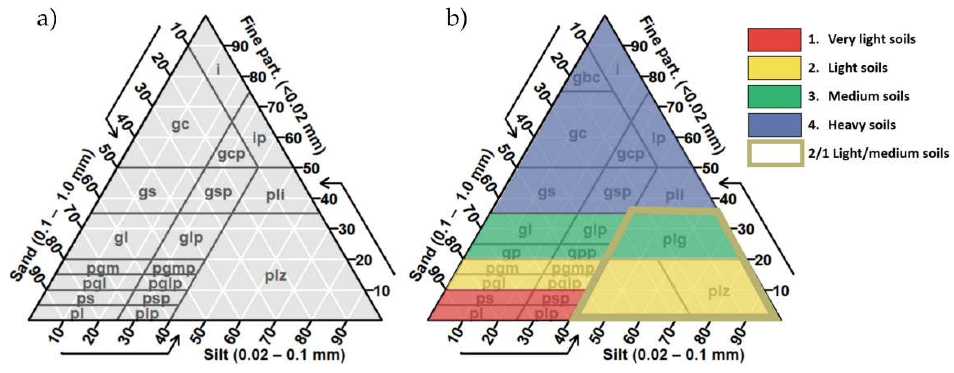
Figure 2.
The locations of the study fields in years 2009-2015.
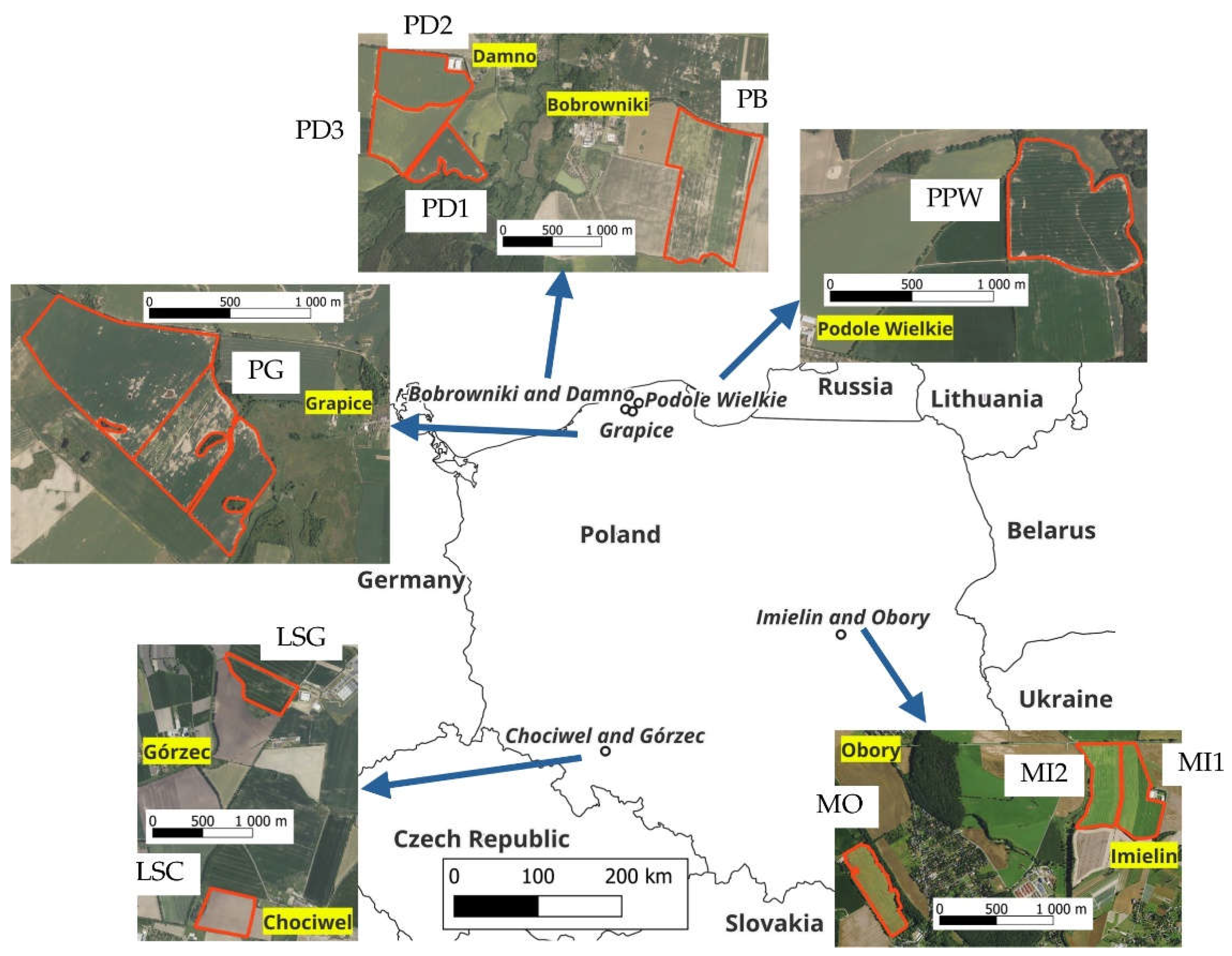
Figure 3.
Soil texture (ST) triangles showing: a) ST classes used on the agricultural soil maps and an example of the determination of good and medium agreement between the map and recent ST status for gs; b) an example of the determination of good and medium agreement between the map and recent ST status for AC 2. Medium soils; c) an example of the determination of good and medium agreement between the map and recent ST status for AC 2/3 – Light/ medium (silty) soils.
Figure 3.
Soil texture (ST) triangles showing: a) ST classes used on the agricultural soil maps and an example of the determination of good and medium agreement between the map and recent ST status for gs; b) an example of the determination of good and medium agreement between the map and recent ST status for AC 2. Medium soils; c) an example of the determination of good and medium agreement between the map and recent ST status for AC 2/3 – Light/ medium (silty) soils.
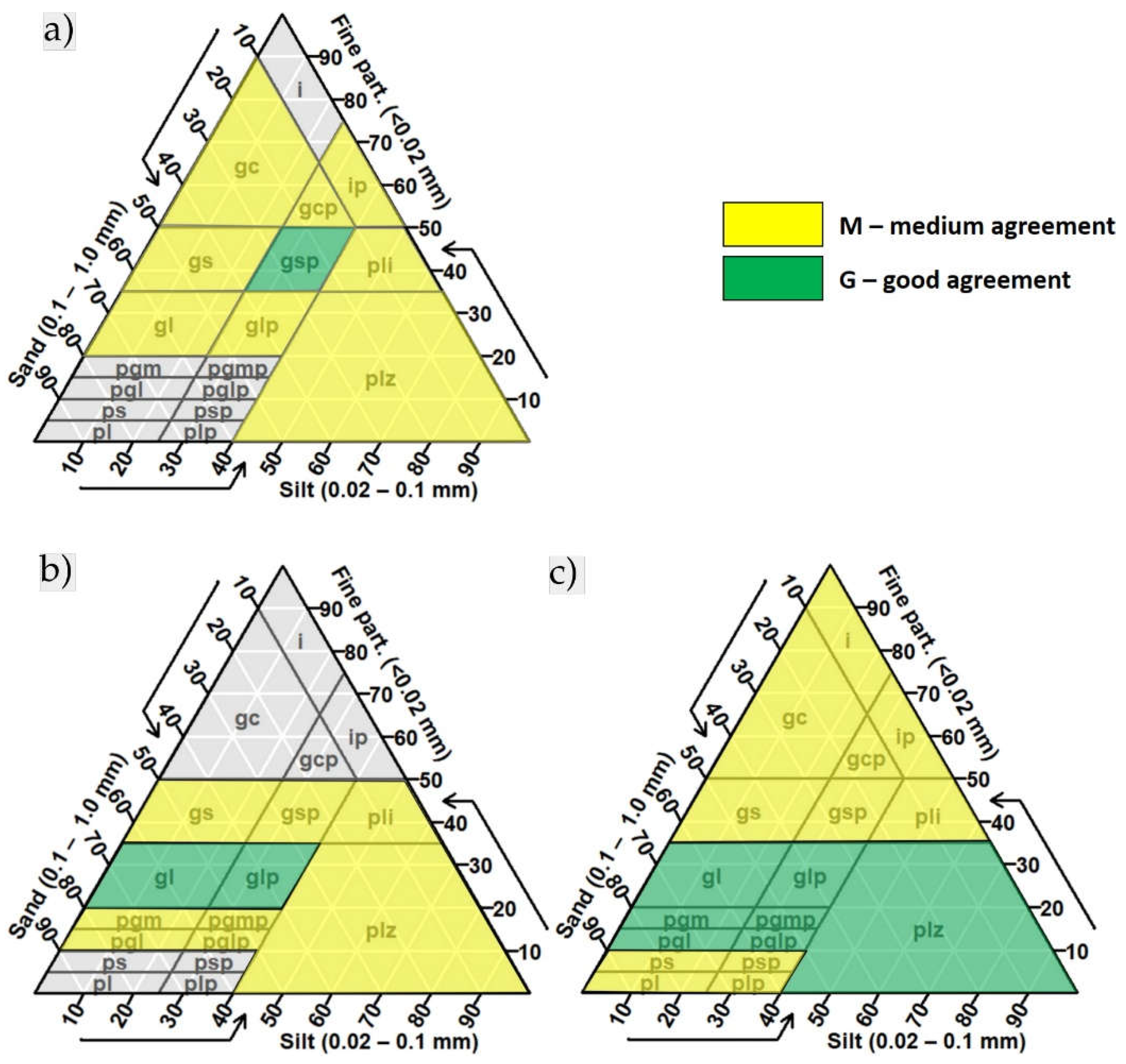
Figure 4.
Field PB – soil sampling points with soil texture classes and agronomic categories according to this study and the agricultural soil map, superimposed on the scan of the original ASM. For an explanation of acronyms coding ST classes, see Table A1.
Figure 4.
Field PB – soil sampling points with soil texture classes and agronomic categories according to this study and the agricultural soil map, superimposed on the scan of the original ASM. For an explanation of acronyms coding ST classes, see Table A1.
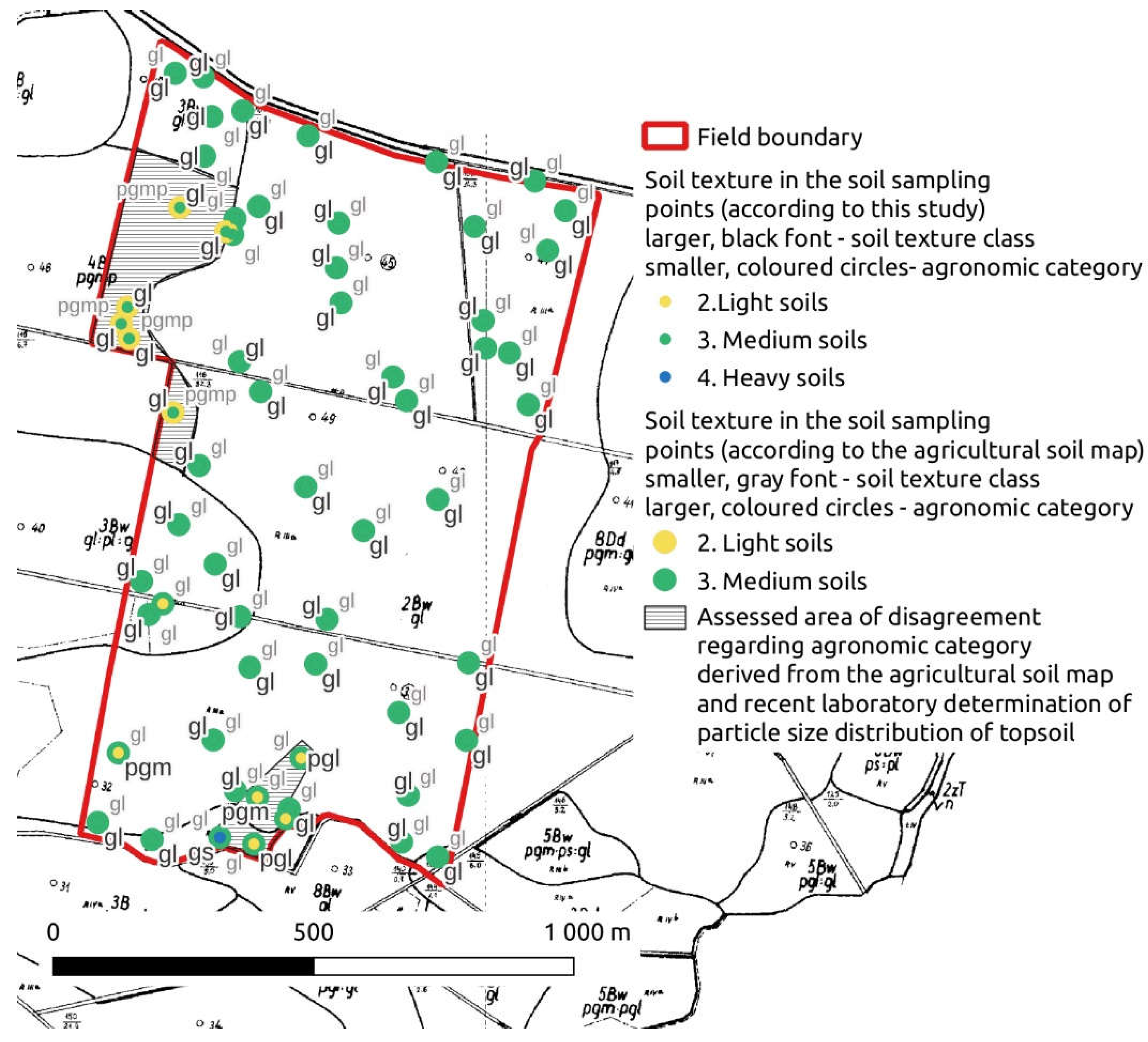
Figure 5.
Field PPW –soil sampling points with soil texture classes and agronomic categories according to this study and the agricultural soil map, superimposed on the scan of the original ASM. For an explanation of acronyms coding ST classes see Table A1.
Figure 5.
Field PPW –soil sampling points with soil texture classes and agronomic categories according to this study and the agricultural soil map, superimposed on the scan of the original ASM. For an explanation of acronyms coding ST classes see Table A1.
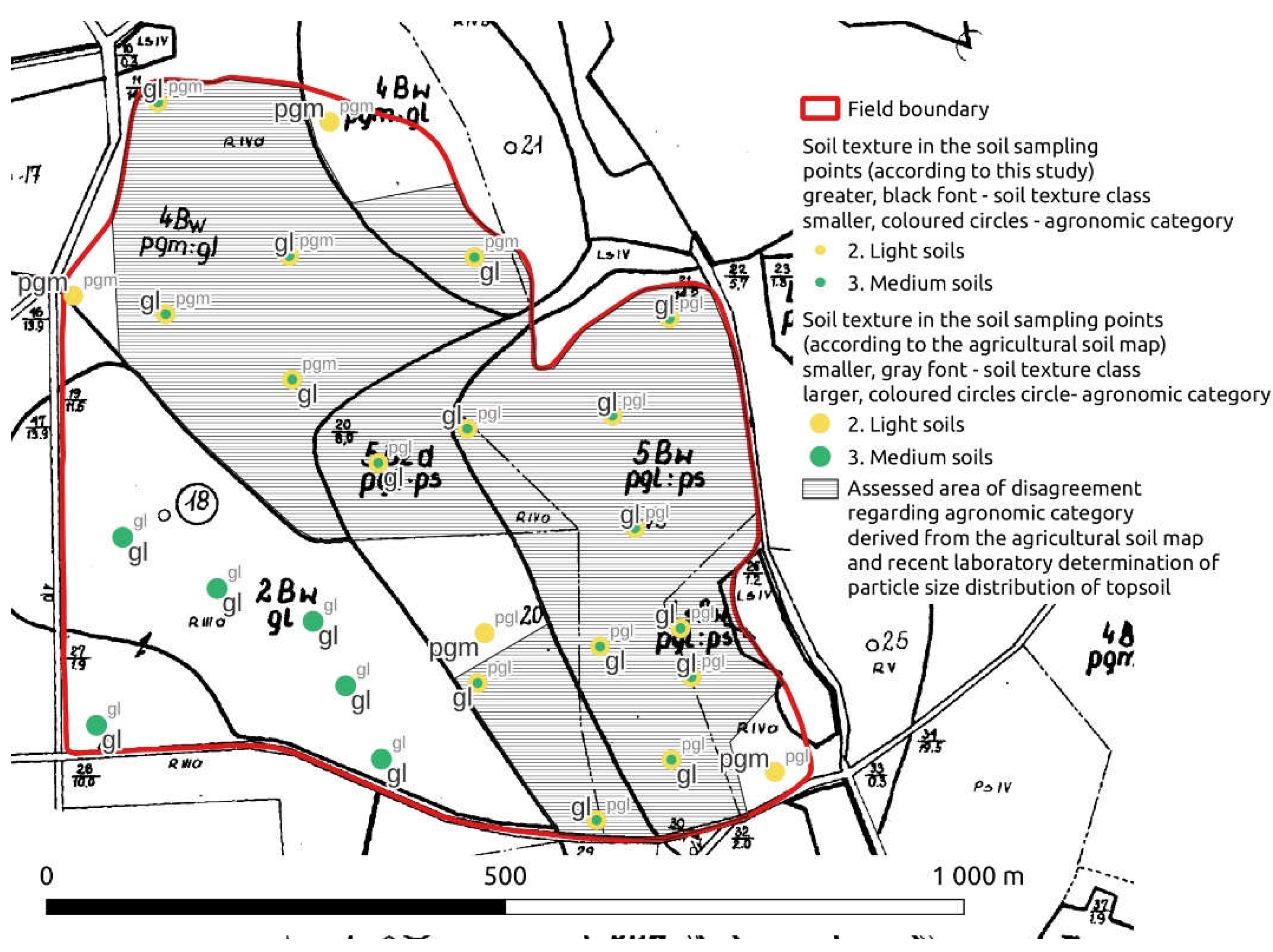
Figure 6.
Field MI2 –soil sampling points with soil texture classes and agronomic categories according to this study and agricultural soil map, superimposed on the scan of the original map. The area of disagreement regarding the agronomic category was delineated according to rules provided in Table 3, i.e. the soil texture classes gl and glp (medium soils) are considered to be in complete agreement with płz which actually may belong to both agronomic categories: light and medium soil, but cannot be exactly divided between them, so for the purpose of this paper it was treated as a separate category of 2/3 Light/medium (silty) soils.
Figure 6.
Field MI2 –soil sampling points with soil texture classes and agronomic categories according to this study and agricultural soil map, superimposed on the scan of the original map. The area of disagreement regarding the agronomic category was delineated according to rules provided in Table 3, i.e. the soil texture classes gl and glp (medium soils) are considered to be in complete agreement with płz which actually may belong to both agronomic categories: light and medium soil, but cannot be exactly divided between them, so for the purpose of this paper it was treated as a separate category of 2/3 Light/medium (silty) soils.
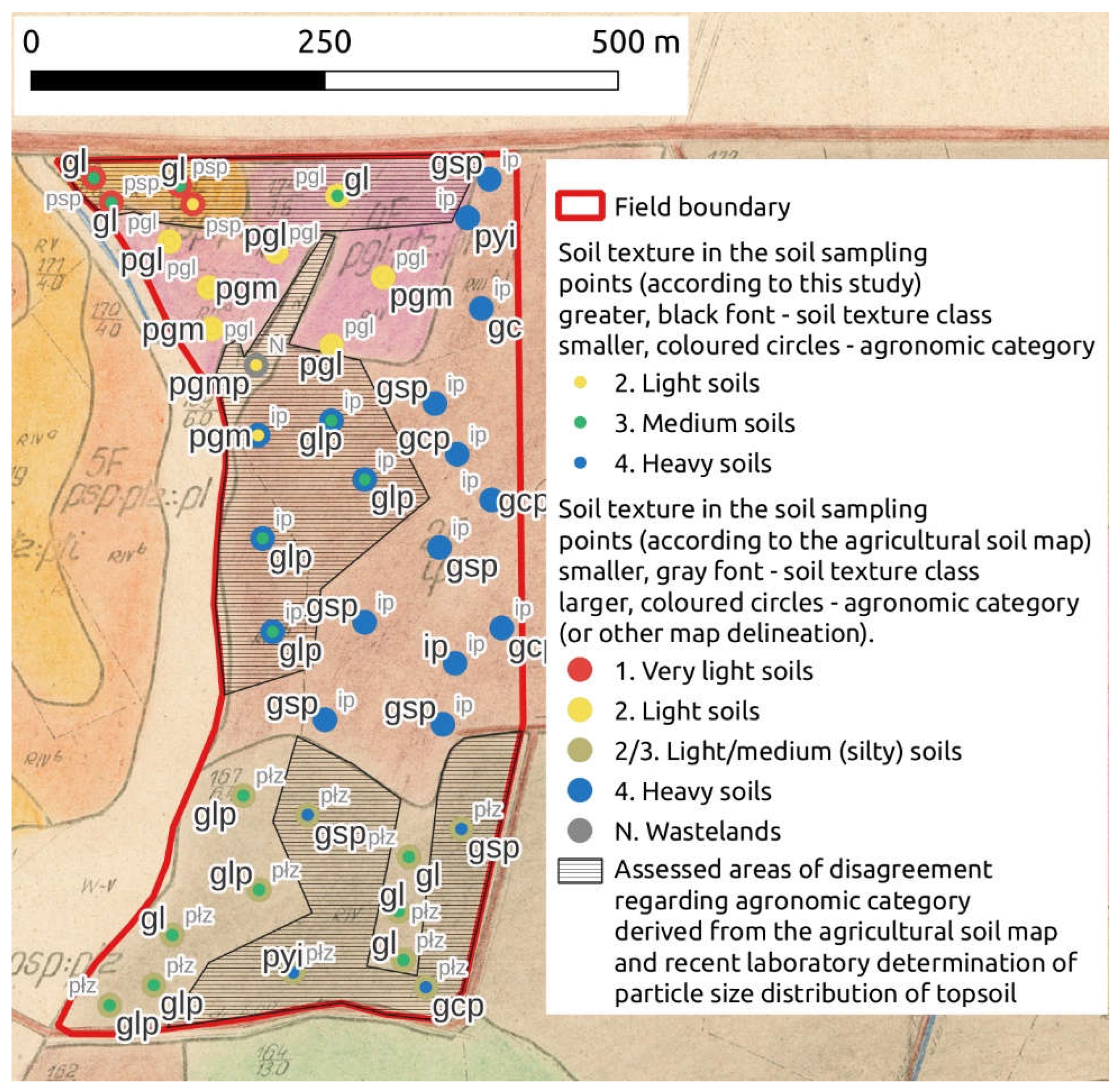
Table 1.
Basic information on the eleven fields studied in years 2009-2015.
| Region (Voivodship) | Locality | Latitude Longitude |
Field | Area (ha) |
Altitude min.-max. (m) |
Prevailing (associated) Reference Soil Group WRB 2023 | Prevailing (associated) topsoil texture class USDA | Soil examination | |
|---|---|---|---|---|---|---|---|---|---|
| Number of topsoil samples | Years of soil sampling | ||||||||
| Pomerania | Bobrowniki | 54°31’ N 17°21’ E |
PB | 107 | 60-68 | Luvisols (Regosols, Phaeozems, Gleysols) | SL (LS) | 61 | 2015 |
| Damno | 54°32’ N 17°18’ E |
PD1 | 22 | 52-65 | Luvisols (Regosols, Cambisols) | SL (LS) | 37 | 2011-2013 | |
| PD2 | 44 | 51-68 | Luvisols (Cambisols, Arenosols, Phaeozems) | SL (LS, L) | 60 | 2013-2014 | |||
| PD3 | 40 | 54-65 | Luvisols (Regosols, Cambisols) | SL (LS) | 26 | 2013-2014 | |||
| Grapice | 54°31' N 17°26' E |
PG | 111 | 48-86 | Luvisols (Retisols, Phaeozems, Arenosols) | SL (LS) | 56 | 2015 | |
| Podole Wielkie | 54°35' N 17°30' E |
PPW | 50 | 59-74 | Luvisols (Retisols, Phaeozems) | SL (LS) | 26 | 2015 | |
| Mazovia | Imielin | 52°05' N 21°11' E | MI1 | 21 | 87 | Fluvisols | SiL (L, LS) | 33 | 2013-2014 |
| MI2 | 21 | 87 | Fluvisols | L (SL, SiL, LS) | 41 | 2013-2014 | |||
| Obory | 52°04' N 21°09' E |
MO | 19 | 105-107 | Luvisols (Phaeozems, Arenosols) | SL (LS, L) | 24 | 2015 | |
| Lower Silesia | Górzec | 50°49' N 17°04' E |
LSG | 21 | 149-159 | Phaeozems | SiL (L, SL) | 38 | 2013-2014 |
| Chociwel | 50°48' N 17°06' E |
LSC | 20 | 168-171 | Luvisols (Phaeozems, Cambisols) | SiL (L) | 37 | 2013-2014 | |
Table 2.
The criteria used for the agreement evaluation between soil texture class shown on an agricultural soil map and determined by a laboratory method.
Table 2.
The criteria used for the agreement evaluation between soil texture class shown on an agricultural soil map and determined by a laboratory method.
| Soil texture class (granulometric group) according to PTG 1956 classification, shown on the map* | Soil texture class (granulometric group) according to PTG 1956 classification, determined in a laboratory for the studied fields | Level of soil texture agreement between the map and this study | |
|---|---|---|---|
| Kind | Value | ||
| ps** | ps | G (good) | 1.0 |
| pl, plp, psp, pgl, pglp | M (medium) | 0.5 | |
| any other | P (poor) | 0.0 | |
| psp | psp | G (good) | 1.0 |
| pl, plp, płz, pgl, pglp | M (medium) | 0.5 | |
| any other | P (poor) | 0.0 | |
| pgl | pgl | G (good) | 1.0 |
| ps, psp, pglp, pgm, pgmp | M (medium) | 0.5 | |
| any other | P (poor) | 0.0 | |
| pglp | pglp | G (good) | 1.0 |
| ps, psp, płz, pgl, pgm, pgmp | M (medium) | 0.5 | |
| any other | P (poor) | 0.0 | |
| pgm | pgm | G (good) | 1.0 |
| pgl, pglp, pgmp, gl, glp | M (medium) | 0.5 | |
| any other | P (poor) | 0.0 | |
| pgmp | pgmp | G (good) | 1.0 |
| pgm, pgl, pglp, płz, gl, glp | M (medium) | 0.5 | |
| any other | P (poor) | 0.0 | |
| płz | płz | G (good) | 1.0 |
| plp, psp, pglp, pgmp, glp, gsp, płi | M (medium) | 0.5 | |
| any other | P (poor) | 0.0 | |
| gl | gl | G (good) | 1.0 |
| pgm, pgmp, glp, gl, gs, gsp | M (medium) | 0.5 | |
| any other | P (poor) | 0.0 | |
| glp | glp | G (good) | 1.0 |
| gl, pgm, pgmp, płz, płi, gsp, gs | M (medium) | 0.5 | |
| any other | P (poor) | 0.0 | |
| gsp | gsp | G (good) | 1.0 |
| gs, gl, glp, płz, płi, ip, gcp, gc | M (medium) | 0.5 | |
| any other | P (poor) | 0.0 | |
| gcp | gcp | G (good) | 1.0 |
| gc, gs, gsp, płi, ip, i | M (medium) | 0.5 | |
| any other | P (poor) | 0.0 | |
| ip | ip | G (good) | 1.0 |
| gc, gcp, gsp, płi, i | M (medium) | 0.5 | |
| any other | P (poor) | 0.0 | |
| płi |
płi | G (good) | 1.0 |
| ip, gcp, gsp, glp, płz | M (medium) | 0.5 | |
| any other | P (poor) | 0.0 | |
* – for explanation of acronyms coding ST classes, see Table A1.1. ** – in this table, we considered only ST groups that were shown on the ASMs of the studied fields.
Table 3.
The criteria used for the agreement evaluation between the agronomic category (AC) derived from an agricultural soil map and determined by a laboratory method.
Table 3.
The criteria used for the agreement evaluation between the agronomic category (AC) derived from an agricultural soil map and determined by a laboratory method.
| AC derived from agricultural soil map (ST classes according to PTG 1956)* |
AC (ST classes according to PTG 1956) determined for the studied fields | Level of agreement between the map and this study | |
|---|---|---|---|
| Kind | Value | ||
| 1. Very light soils (ps and psp) | 1. (pl, plp, ps, psp) | G (good) | 1.0 |
| 2. (pgl, pglp, pgm, pgmp, płz) and 2/3 (płz) | M (medium) | 0.5 | |
| any other | P (poor) | 0.0 | |
| 2. Light soils (pgl, pglp, pgm, pgmp) | 2. (pgl, pglp, pgm, pgmp) | G (good) | 1.0 |
| 1. (pl, plp, ps, psp), 2/3 (płz) and 3 (gl, glp) | M (medium) | 0.5 | |
| any other | P (poor) | 0.0 | |
| 2/3. Light/medium (silty) soils (płz) | 2. (pgl, pglp, pgm, pgmp), and 3 (gl, glp) and 2/3 (płz) | G (good) | 1.0 |
| 1. (pl, plp, ps, psp) and 4 (gs, gsp, płi, gc, gcp, i, ip) | M (medium) | 0.5 | |
| - | P (poor) | 0.0 | |
| 3. Medium soils (gl, glp) | 3. (gl, glp) and 2/3 (płz) | G (good) | 1.0 |
| 2. (pgl, pglp, pgm, pgmp) and 4. (gs, gsp, płi, gc, gcp, i, ip) | M (medium) | 0.5 | |
| any other | P (poor) | 0.0 | |
| 4. Heavy soils (gsp, gcp, ip, płi) |
4. (gs, gsp, płi, gc, gcp, i, ip) | G (good) | 1.0 |
| 3. (gl, glp) and 2/3 (płz) | M (medium) | 0.5 | |
| any other | P (poor) | 0.0 | |
* – for the explanation of the codes used to denominate each AC (number and name) and ST classes (abbreviations), see Table A1.
Table 4.
The number of soil samples in ST classes* (the upper line for each field) and their approximated areas** in hectares (the lower line for each field) shown on the agricultural soil map and the ACs derived from these classes for fields considered in this study.
Table 4.
The number of soil samples in ST classes* (the upper line for each field) and their approximated areas** in hectares (the lower line for each field) shown on the agricultural soil map and the ACs derived from these classes for fields considered in this study.
| Region | Locality | Field | ACs, ST classes, and other mapping units*** according to the agricultural soil maps | |||||||||||||||
|---|---|---|---|---|---|---|---|---|---|---|---|---|---|---|---|---|---|---|
| 1. Very light | 2. Light | 2/3. Light/medium | 3. Medium | 4. Heavy | Emt | N | T | |||||||||||
| ps | psp | pgl | pglp | pgm | pgmp | płz | gl | glp | gsp | gcp | ip | płi | ||||||
| Pomerania | Bobrowniki | PB | 6 7.0 |
55 99.9 |
||||||||||||||
| Damno | PD1 | 34 19.2 |
3 2.7 |
|||||||||||||||
| PD2 | 16 12.4 |
44 31.4 |
||||||||||||||||
| PD3 | 2 0.9 |
12 15.8 |
12 23.1 |
|||||||||||||||
| Grapice | PG | 2 2.7 |
7 16.5 |
4 3.8 |
42 86.7 |
1 0.9 |
||||||||||||
| Podole Wielkie | PPW | 13 21.2 |
7 14.5 |
6 13.9 |
||||||||||||||
| Mazovia | Imielin | MI1 | 22 14.2 |
11 7.4 |
||||||||||||||
| MI2 | 4 0.5 |
7 3.6 |
12 6.4 |
17 10.1 |
1 0.4 |
|||||||||||||
| Obory | MO | 5 2.4 |
16 12.9 |
3 3.1 |
||||||||||||||
| Lower Silesia | Górzec | LSG | 20 8.6 |
13 8.8 |
2 1.9 |
3 0.9 |
||||||||||||
| Chociwel | LSC | 13 7.8 |
24 12.5 |
|||||||||||||||
| Sum within | ST class | 7 5.1 |
4 0.5 |
45 55.1 |
4 3.8 |
111 149.0 |
6 7.0 |
34 20.6 |
64 116.9 |
59 57.2 |
33 16.0 |
13 8.8 |
28 17.5 |
26 14.4 |
1 0.9 |
1 0.4 |
3 0.9 |
|
| AC | 11 5.6 |
166 214.9 |
34 20.6 |
123 174.1 |
100 56.7 |
1 0.9 |
1 0.4 |
3 0.9 |
||||||||||
* – for an explanation of acronyms coding ST classes, see Table A1. ** – the area was derived from digitalized agricultural soil maps 1:25000 (except fields LSG and LSC, 1:5000 digitalized maps), and thus it does not reflect exactly the area of particular delineation according to all 1:5000 maps. *** – the other mapping units are the areas that were present during the preparation of the agricultural soil map, but currently are cropped with annual crops. The code Emt shown on the map of field PG denominates a kind of Histosol (in Polish: gleby mułowo-torfowe, i.e. soils developed limnic sediments on peat), the code N shown on the map of field MI2 is used for waste lands and the code T shown on the map of this field LSG denominates peat (in Polish: torf) [Bartoszewski et al. 1965].
Table 5.
Comparison of soil texture classes (STCs) within the studied fields according to the agricultural soil maps and recent laboratory evaluation.
Table 5.
Comparison of soil texture classes (STCs) within the studied fields according to the agricultural soil maps and recent laboratory evaluation.
| Region | Locality | Field | Delineations on the map | Map agreement with recent ST status | ||||
|---|---|---|---|---|---|---|---|---|
| STC* (number of samples) | Within delineation | Within the field | ||||||
| According to the map | According to recent studies | Pur. (%) |
AA (%) |
Pur. (%) |
AA (%) |
|||
| Pomerania | Bobrowniki | PB | pgmp (6) | gl (6) | 0.0 | 50.0 | 78.7 | 87.7 |
| gl (55) | gl (48), pgm (4), pgl (2), gs (1) | 87.3 | 91.8 | |||||
| Damno | PD1 | pgm (34) | gl (23), pgm (7), pgl (2), pgmp (1), gs (1) | 20.6 | 58.8 | 21.6 | 59.5 | |
| glp (3) | gl (2), glp (3) | 33.3 | 66.7 | |||||
| PD2 | pgm (16) | gl (13), pgm (2), gs (1) | 12.5 | 53.1 | 5.0 | 51.7 | ||
| glp (44) | gl (39), glp (1), gs (2), pgm (2) | 2.2 | 51.1 | |||||
| PD3 | pgl (2) | gl (2) | 0.0 | 0.0 | 11.5 | 50.0 | ||
| pgm (12) | gl (7), pgm (3), pgl (1), gs (1) | 25.0 | 58.3 | |||||
| glp (12) | gl (11), gs (1) | 0.0 | 50.0 | |||||
| Grapice | PG | ps (2) | pgm (1), pgmp (1) | 0.0 | 0.0 | 10.7 | 46.4 | |
| pgl (7) | gl (3), pgmp (2), pgm (1), pgl (1) | 14.3 | 35.7 | |||||
| pglp (4) | gl (4) | 0.0 | 0.0 | |||||
| pgm (42) | gl (29), pgm (5), glp (4), pgmp (2), pgl (2) | 11.9 | 56.0 | |||||
| Emt** (1) | pgm (1) | 0.0 | 0.0 | |||||
| Podole Wielkie | PPW | pgl (13) | gl (11), pgm (2) | 0.0 | 7.7 | 30.8 | 44.2 | |
| pgm (7) | gl (5), pgm (2) | 28.6 | 64.3 | |||||
| gl (6) | gl (6) | 100.0 | 100.0 | |||||
| Mazovia | Imielin | MI1 | ip (11) | gsp (7), płz (2), płi (2) | 0.0 | 40.9 | 9.1 | 47.0 |
| płz (22) | gsp (6), glp (6), płz (3), płi (3), gs (2), gl (1), pgmp (1) | 12.0 | 50.0 | |||||
| MI2 | psp (4) | gl (3), pgl (1) | 0.0 | 12.5 | 9.8 | 36.6 | ||
| pgl (7) | pgl (3), pgm (3), gl(1) | 42.9 | 64.3 | |||||
| płz (12) | gl (4), glp (4), gsp (2), płi (1), gcp (1) | 0.0 | 29.2 | |||||
| ip (17) | gsp (6), glp (4), gcp (3), ip (1), płi (1), gc (1), pgm (1) | 5.9 | 38.2 | |||||
| N*** (1) | pgmp (1) | 0.0 | 0.0 | |||||
| Obory | MO | ps (5) | pgm (2), pgl (1), gs (1), gsp (1) | 0.0 | 10.0 | 29.2 | 47.9 | |
| pgl (16) | pgm (6), pgl (5), gl (3), pgmp (1), glp (1) | 31.3 | 53.1 | |||||
| gl (3) | gl (2), gs (1) | 66.7 | 83.3 | |||||
| Lower Silesia | Górzec | LSG | gsp (20) | gsp (8), gcp (4), gl (4), glp (3), płz (1) | 40.0 | 70.0 | 31.6 | 61.8 |
| gcp (13) | gsp (6), płi (4), gcp (3) | 23.1 | 61.5 | |||||
| płi (2) | płi (1), gsp (1) | 50.0 | 75.0 | |||||
| T**** (3) | płz (1) | 0.0 | 0.0 | |||||
| Chociwel | LSC | gsp (13) | gcp (9), gsp (4) | 30.8 | 65.4 | 13.5 | 56.8 | |
| płi (24) | gsp (18), gcp (5), płi (1) | 4.2 | 52.1 | |||||
* – for explanation of acronyms coding ST classes see Table A1. ** – Emt is a kind of organic soil („gleby mułowo-torfowe” in Polish) *** – N is a wasteland **** – T is a peat.
Table 6.
Comparison of agronomic categories (ACs) of the studied fields derived from agricultural soil maps and from recent ST evaluation.
Table 6.
Comparison of agronomic categories (ACs) of the studied fields derived from agricultural soil maps and from recent ST evaluation.
| Region | Locality | Field | Delineations on the map | Map agreement with recent ST status | ||||
|---|---|---|---|---|---|---|---|---|
| AC* (number of samples) | Within delineation | Within the field | ||||||
| According to the map | According to recent studies | Pur. (%) |
AA (%) |
Pur. (%) |
AA (%) |
|||
| Pomerania | Bobrowniki | PB | Light (6) | Medium (6) | 0.0 | 50.0 | 78.7 | 93.6 |
| Medium (55) | Medium (48), light (6), heavy (1) | 87.3 | 93.6 | |||||
| Damno | PD1 | Light (34) | Medium (23), light (10), heavy (1) | 29.4 | 63.2 | 38.2 | 66.2 | |
| Medium (3) | Medium (3) | 33.3 | 66.7 | |||||
| PD2 | Light (15) | Medium (12), light (2), heavy (1) | 12.5 | 56.3 | 70.0 | 84.2 | ||
| Medium (45) | Medium (42), heavy (2), light (2) | 90/9 | 95.5 | |||||
| PD3 | Light (14) | Medium (9), light (4), heavy (1) | 28.6 | 60.7 | 57.7 | 76.9 | ||
| Medium (12) | Medium(11), heavy (1) | 91.7 | 95.8 | |||||
| Grapice | PG | Very light (2) | Light (2) | 0.0 | 50.0 | 23.2 | 60.7 | |
| Light (53) | Medium (40), light (13) | 24.5 | 62.3 | |||||
| Emt** (1) | Light (1) | 0.0 | 0.0 | |||||
| Podole Wielkie | PPW | Light (20) | Medium (16), light (4) | 20.0 | 60.0 | 38.5 | 69.2 | |
| Medium (6) | Medium (6) | 100.0 | 100.0 | |||||
| Mazovia | Imielin | MI1 | Heavy (11) | Heavy (9), light/medium (2) | 81.8 | 90.9 | 60.6 | 80.3 |
| Light/medium (22) | Heavy (11), medium (7), light/medium (3), light (1) | 50.0 | 75.0 | |||||
| MI2 | Very light (4) | Medium (3), light (1) | 0.0 | 12.5 | 63.4 | 75.6 | ||
| Light (7) | Light (7), medium (1) | 85.7 | 92.9 | |||||
| Light/medium (12) | Medium (8), heavy (4) | 66.7 | 83.3 | |||||
| Heavy (17) | Heavy (12, medium (4), light (1) | 70.6 | 82.4 | |||||
| N*** (1) | Light (1) | 0.0 | 0.0 | |||||
| Obory | MO | Very light (5) | Light (3), heavy (2) | 0.0 | 30.0 | 50.0 | 75.0 | |
| Light (16) | Light (12), medium (4) | 75.0 | 87.5 | |||||
| Medium (3) | Medium (2), heavy (1) | 66.7 | 83.3 | |||||
| Lower Silesia | LSG | Heavy (35) | Heavy (27), medium (7), light/medium (1) | 77.1 | 88.6 | 71.0 | 81.6 | |
| T**** (3) | Light/medium (1) | 0.0 | 0.0 | |||||
| Chociwel | LSC | Heavy (37) | Heavy (37) | 100.0 | 100.0 | 100.0 | 100.0 | |
Table 7.
The agreements of ST classes shown on agricultural soil maps and ACs derived from these classes for the eleven fields considered in this study.
Table 7.
The agreements of ST classes shown on agricultural soil maps and ACs derived from these classes for the eleven fields considered in this study.
 |
Disclaimer/Publisher’s Note: The statements, opinions and data contained in all publications are solely those of the individual author(s) and contributor(s) and not of MDPI and/or the editor(s). MDPI and/or the editor(s) disclaim responsibility for any injury to people or property resulting from any ideas, methods, instructions or products referred to in the content. |
© 2024 by the authors. Licensee MDPI, Basel, Switzerland. This article is an open access article distributed under the terms and conditions of the Creative Commons Attribution (CC BY) license (http://creativecommons.org/licenses/by/4.0/).
Copyright: This open access article is published under a Creative Commons CC BY 4.0 license, which permit the free download, distribution, and reuse, provided that the author and preprint are cited in any reuse.


