Submitted:
09 September 2024
Posted:
11 September 2024
You are already at the latest version
Abstract
Storied Rocks (Tumpituxwinap) is a term of reference used by the Numic Speaking tribal elders whom we have worked with for over 60 years on an estimated 200 ethnographic studies. Key in this analysis are the protocols for approaching, interacting, and using the places where Storied Rocks have been located. Concomitant with these traditional protocols are ones established to resolve the curiosity of non-Natives about why they are in a particular place and what they mean. This analysis shares the cultural understandings of Tribal representatives who participated in these ethnographic studies. Studies used in the analysis were funded by U.S. federal agencies, supported by federally recognized Native American tribal governments, and composed with the cultural understandings shared and made public by tribally appointed elders to clarify the conundrums that are Storied Rocks.
Keywords:
Rock Paintings
; Pictographs
; Rock Peckings
; Petroglyphs
; Native American Culture Heritage
; Southwestern USA
; Western USA
; Ethnography
; Geosites
; Geotrails
; and Geoscapes
Here it comes out like a miracle. He’s the one who knows it. They had regulations and rules in the Indian traditional ways. It shows the chief where the people are. It shows the regulations, the way he dreamed it and visualized it. They are to take care of one another.
Uru’a niav puaxantem niavung niavingwam.
Exe marapexantem negnwe urapexants
urapexantem.
Senangwavi paavingw
Tevats --
penitikaipexaikung.
Senangwavi paavingw penitikaipexaiang,
Pianem Tevip.
Ungwaisamp
niavi
penitikapexant.
Neni panipan puchxwan.
Figure 1.
Religious Leader Talking With Power Rock.
[There was a chief medicine person among their chiefs at this time.
Indeed there were a lot of people
at that time.
That way the Creator’s younger brother showed.
The Creator’s younger brother showed
how Mother Earth is.
Only to him,
to the chief,
did he show it.
That’s how I personally understand (it).]
Clifford Jake, from the Paiute Indian Tribe of Utah, at the Power Rock Site.
(Transcribed by David Shaul PhD 1999)
1. Introduction
This is an analysis of the selective meanings of Storied Rocks (Tumpituxwinap) shared by Native American people in the Western United States (Stoffle et al. 1995). A special focus of this analysis is on the relationships between Storied Rocks and places in natural stone that are understood by Native American people as being portals to other dimensions. Knowledge about the relationship between Storied Rocks and portals is largely restricted to spiritual specialists; however, information about these locations has periodically been shared by Tribal representatives in order to protect these sacred areas from potential damage. Thus, most of the studies that this analysis is based upon were initiated by land management agencies that were studying potential adverse impacts to Native American heritage areas deriving from a proposed ground disturbing development. The studies are generally termed Environmental Impact Assessments (EIA) or Environmental Impact Statements (EIS) (SIA 2003; Stoffle 2000, 2007). In many cases, Tribal governments and elders decided that the potential development threat to these sacred areas was greater than the risk of publicly revealing their locations and traditional purposes. Tribal elders recommended that sharing knowledge of these sacred areas would stimulate land managers to better assure formal protection of the Storied Rocks.
The cultural observations structuring this analysis of Storied Rocks derive from ethnographic studies. All of these studies were funded by U.S. federal and state land management agencies. Tribal governments chose to participate in the studies to achieve collective goals and their appointed elders chose to participate in the field work so their voices would be heard and their knowledge used for preservation. The findings of all studies were approved by the participating elders, their cultural departments, and their Tribal governments before the reports were submitted to the land management agencies that funded the study. Each study was intended to identify the cultural meaning of Storied Rocks and to have these observations shared with the land management agencies for Environmental Impact Assessments, agency public land interpretations, and displays for the education of visitors. Tribal participation critically hinged on their trust that adding a Native American voice in the teaching of the land managers would better protect these heritage resources. Ultimately, these studies indicated that the geological location of the Storied Rocks was critical in understanding them.
Currently, rock paintings and peckings are understood by the academic community as heritage components (1) of places (also known as geosites), (2) of where topographically influenced ceremonial trails connect places (also known as geotrails), and (3) of functionally integrated components of cultural landscapes (also known as geoscapes). The utility of these dual sets of interrelated terms is that the vernacular terms are well understood because they have been in use for hundreds of years and the geo-terms are now grounded in worldwide discussions guided by the United Nations. So, these terms of reference carry different information and implications.
2. Native Stipulations
Stipulations are needed to understand Native American statements regarding Storied Rock as these are included in this analysis (Schroeder, Perez, and Tellez 2022). Throughout this analysis, only key stipulations are included. A simple one, however, is you have to talk with it because it is alive and has rights just like people (Stoffle et al. 2015, 2016).
During an ethnographic field trip in the Mohave Desert, I was driving a car filled with respected Native American plant specialists. One of these specialists, Mary Lou Brown, said, “Stop the car and go get me a piece of that plant in the road so I can tell what it is.” Excited, I jumped out and ran ahead, grabbed the plant, and pulled it up by the roots. I brought it back to her and she scolded me by saying “Oh, Richard have you learned nothing.” I had not explained to the plant why I needed a piece of it and then I killed it by pulling the whole plant out of the ground.
3. The Earth
A Native stipulation from one of our studies explains that a fundamental component of any discussion of rock marking are the rocks themselves. Rocks are not inanimate; they have a spiritual value and fit into the larger scheme of things (Zedeño et al. 1999: 148).
According to one tribal representative, the animals were once people and when humans came into existence, all the animals transformed for their benefit (A Chemehuevi Paiute elder). During this remote mythic time, all of human culture was constituted. Many of the transformations were into stone. Understand that the tempi nengwexaipexai `the rocks were once people’. Many prominent rocks were once people or animals. Long ago, the animals of the south Death Valley area went north to steal a pine nut. The animals of the north did not want to share pine nuts, so when one was taken, they began chasing the others south. When a southern animal was caught, it was killed and transformed into stone. Finally, they caught Raven, who had hidden the pine nut in his plumage. His black feathers were scattered about when he turned to stone, and this accounts for the black boulders found all over. But Raven did not have that pine nut. Coyote took it from him and scattered it all over the south for the people. (Timbisha Shosone elder).
The whole world, including rocks, has been alive since Time Immemorial. The markings on rock cliffs (or particular rocks) are therefore part of the cosmos. Power is revealed through dreams. People dream of long life, gambling luck, long distance running ability, and success in hunting or doctoring. Dream-induced powers usually depend on a continuing relationship with the supernatural being granting the power. Native shamans generally are dreamers with more or stronger powers.
Based on his ethnographic and linguistic work with Numic people, Hultkrantz (1986: 635) maintains that Numic dreaming is about power. Dreams often direct a person to a particular place. The following text was recorded and subsequently transcribed by Hultkrantz:
Uniakangw penitikaipexa uru’a.
Ungwasu maniaku tsipopexaiakw.
Axaru aru’asamp tempi. (A Southern Paiute)
That’s the way he showed it to him.
So he marked it --
whatever it is - on the rock.
Rock art is connected to the whole.
Senangwavi paavingw penitikaipexaiang,
Pianem Tevip. (A Southern Paiute)
A Numic person maintained that the Creator’s younger brother showed him how Mother Earth is Power and dreams and rock marking meanings are revealed only to specific individuals.
Ungwaisamp
niavi
penitikaipexant. (A Southern Paiute)
Only to him,
the chief,
did he show it.
Numic people interviewed by Hulkrantz stipulated that to reveal the meaning of a rock marking would render the power useless.
4. Portals
Although far beyond the scope of this analysis, it is clear that humans have throughout time responded to pieces of Earth at various scales such as portable stones, steep cliffs, large residual stone monuments, deep canyons, topographically distinct landscapes, or snowcapped mountains. Humans as cultural communities have done this when they have become attached through long periods of co-adaptation to their traditional habitats. Stable human communities have commonly resided in the same habitat for thousands of years.
Professor Cristopher Tilley (1994, 2004, 2010), a foremost English archaeologist, studied European adaptations to most of these types of Earth features. In his analysis, he always uses the largest spatial frames such as landscapes to situate the diversity of community responses to Earth features. His work is summarized by terms such as the Phenomenology of Landscape Places, Paths, and Monuments and The Materiality of Stone: Explorations in Landscape Phenomenology. His studies document that over thousands of years, the people in England and on the European continent have lived with Earth’s landscapes in a mutual relationship, which modified them both through time.
Portals are an aspect of Earth features where the dimension now lived in is traversed to another dimension through a break, which usually takes the form of a physical hole in the Earth. Portals is a term used to discuss the structure and function of Other Dimension breaks. Portals discussed by tribally appointed culture experts can be small finger size holes, a crack in the face of a freestanding stone, caves of all sizes, stone bridges, and massive eroded rock shelters. Rock peckings and paintings signify the location of a portal, culturally appropriate approaches, use protocols, the contents of the Other Dimension, and possible dangers of using the portal. Passage through a portal can result in the traveler not returning, experiencing a gender change, gaining new knowledge of songs, medicine plants, and seeking new approaches to world balancing ceremonies. Traditional ceremonial runners, which were common in the western US, spiritually and physically moved through space and time without the latter elapsing. Generally, the Other Dimension is the reverse of the dimension now lived so at least there is a shift from day to night.
Movement through a portal can be accomplished by any Earth feature since they all have life energy called Puha, emotions related to a sense of self, and the agency to act on their desires (Miller 1983; Van Vlack 2012; Van Vlack 2018). Animals who are angered with Humans can open portals and stay apart from the now lived dimension for as long as they wish. Springs that are not treated properly with respectful prayers and offerings can retreat to their Other Dimension and never appear again in the now lived dimension. Crystals can move to another dimension. Spiritual beings like Water Babies can move between dimensions along both waterways and the path of volcanic lava flows.
All components of the above stipulations are discussed by elders in our ethnographic studies. The studies were approved for the education of the public and the culturally appropriate management of the portals and related Earth features where they exist. It is essential to further stipulate that the full knowledge of portals should not be known outside of Native American cultural communities. In this analysis, only the broader outlines of the relationships between dimensions, portals, powerful Earth features, rock pecking, and paintings are publicly shared.
5. Methods
The integrating methodology for the ethnographic study of Storied Rocks begins by taking elders representing the cultural connections between a people and a study area that contains peckings or paintings. Elders are left alone after a brief orientation regarding why the federal agency funded them to be at this location. They then absorb and understand where they are by quietly being in the place. Often these elders leave the Storied Rock and climb to the highest surrounding point. There they talk with the place and whatever surrounds it. These talks may be with Indian Tobacco growing above or out of the face of the Storied Rock panel. Alternatively, these talks may be with little birds that flit around. To better understand the place, they talk with it. They ask the plants and animals why they have come to this location. Plants, animals, bugs, and other obvious forms of life tend to be attracted to where the Storied Rock occurs because power (or Puha) attracts more Puha. Storied Rocks define the kinds of power and their locations.
It is an epistemological premise of all participating Tribal cultural communities (aka ethnic groups) that the Earth and all of its elements are alive, sentient, and have agency. Thus, respectful interactions are required. Elders interpreting a study area that contains multiple Storied Rocks are provided hours to be at this place of research. Procurals of arriving, talking with rocks and correctly understanding them are required. The rocks are alive sitting in a living mountain surrounded by living water on a complex landscape filled with topographic features, plants, and animals that stretch for miles. All Earth elements must be respected so that the elders can understand and share. Perhaps one of the most important discussions of this critical methodological moment is provided by Florence Shipek (1985) who analyzed the protocols required of the Kumeyaay elders when they consulted on Kuuchamaa, their sacred mountain. Shipek explains why elders cannot just walk up to any element of the Earth and ask it questions. It must be talked with like a person and asked for its permission to share information.
The cultural story of paintings, peckings, and portals in stone cannot come from one interview. Individuals may or may not know all about a portal, but few would share all they know. So multiple interviews conducted at different times are needed. There is no cultural survey that can measure the distribution of sacred knowledge; however, our research team explored the issue with an analysis of selected traditional plant knowledge (Stoffle, Halmo, and Evans 1999). A question developed after our research conducted hundreds of plant interviews with elders from a dozen tribes and we were still getting new information about plants during new interviews. The resulting analysis selected plants that had been interviewed a number of times involving different Numic elders, kinds of interviewers, and areas. Our conclusion was that plant knowledge is unevenly distributed for a number of reasons, but taken together, shared plant knowledge constitutes a single knowledge domain. Our analysis demonstrates that it takes up to 16 plant interviews with knowledgeable people conducted over time to have a holistic understanding of the cultural role and importance to Numic people. It is suggested that these findings apply to the analysis of specific Story Rock places and specific patterns of paintings and peckings.
6. Storied Rock Cases
The cultural pattern of Storied Rocks is illustrated for this analysis by two Native American heritage cases (1) a heritage geosite that has a Solar Calendar on the face of a high Sandstone fin in Southern Utah and (2) a heritage geoscape complex involving multiple volcanic events in a massive caldera in Nevada. Data for all studies derived from tribal and agency participation during multiple proposed environmental developments over a period of years. The information shared by tribal elders was used in EIAs of development proposals.
The Storied Rock locations all have water, edible plants, medicinal plants, and animal resources in their vicinity. Major springs and rivers are nearby, and all areas have panoramic viewscapes. Pilgrims traveling to each area traveled along a pilgrimage trail (or geotrail), which has subsequently been documented with ethnographic interviews. These pilgrimage trails are commemorated with both rock markings and offerings at places that are understood by elders as pilgrim prayer locations.
7. A Solar Calendar
Dramatically, a large red sandstone fin, with a 7-foot high by 28-foot-deep hole in it, is located more than 100 feet above the surface of the sandy ground. The fin rises on a high elevation plateau in Southern Utah (Figures B, C). The hole contains a 5-foot-long freestanding oval stone which is hand smoothed and fully covered with one integrated pecking. The stone extends to the entrance of the cave where a V-shaped crack in the ceiling emits a small shaft of light. This light shines variously across a series of parallel groves along the lip of the stone, marking the movement of night lights: such as when the sun rises and sets, and when the moon rises and sets.
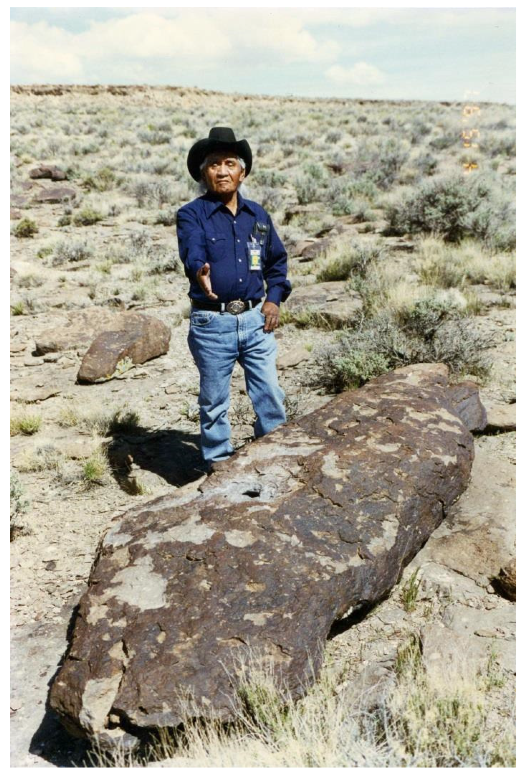
Tribally appointed elders participating in EIA ethnographic studies in 1983 identified the location of the Solar Calendar (Stoffle, Dobyns, and Evans 1983: 115-118,179). Elders only revealed the location and function of the solar calendar when they realized that the study area for a large 500KV powerline and its access road would pass immediately next to the fin (Stoffle et al. 2008; Stoffle et al. 2013). At the time of the Intermountain Power Project (IPP) ethnographic visit to the Solar Cave, it was well known by members of the Shivwits, Indian Peaks, and Kaibab Tribes. One member of the Shivwits Tribe had recently visited the cave. The area surrounding the cave was quite isolated having only a few dirt rancher roads and no signage.
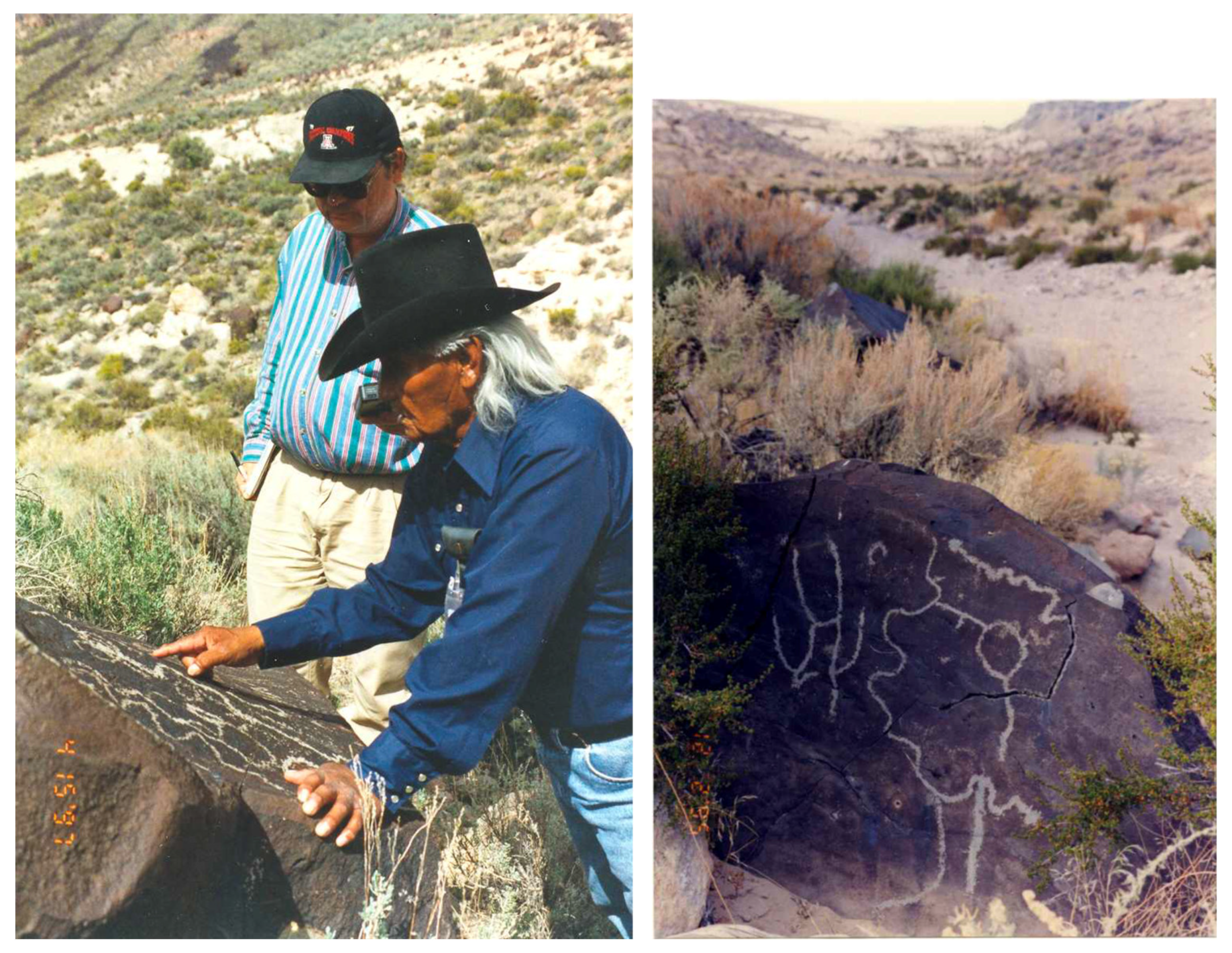
Indian people representing their tribes have been interviewed at the Solar Calendar and nearby sites twice in 33 years. The initial interviews at the Solar Calendar were conducted in 1983 by Richard Stoffle during site visits on the Intermountain-Adelanto Bipole I Transmission Line of the Intermountain Power Project (Stoffle, Dobyns, and Evans 1983). The IPP study involved potential impacts of 500KV electrical powerlines and their associated access roads along more than 500 miles of study corridor, ranging from Delta, Utah to a power station in the central Mohave Desert in California. The ethnographic study design involved participating Tribal governments selecting representatives to visit and share cultural knowledge about portions of potentially impacted areas. A mail survey was sent to members of various Paiute tribes asking for written input on potential impacts. During the 1983 study, three people were involved in the site visit to that portion of the IPP study corridor that passed the Solar Calendar, Rods Spring, and places to the north. Interviews were conducted with Dan Bulletts and Mary Snow, culturally experienced elders who have passed away since the study. A younger Paiute representative, Ferman Grayman was also interviewed as part of the study. He returned along with new elders (Figure 4) during the Old Spanish Trail Study (Stoffle et al. 2006) to share his observations based on his 33 yearlong perspectives.
Figure 2.
Soar Calendar Up Slope from Toniquint River.
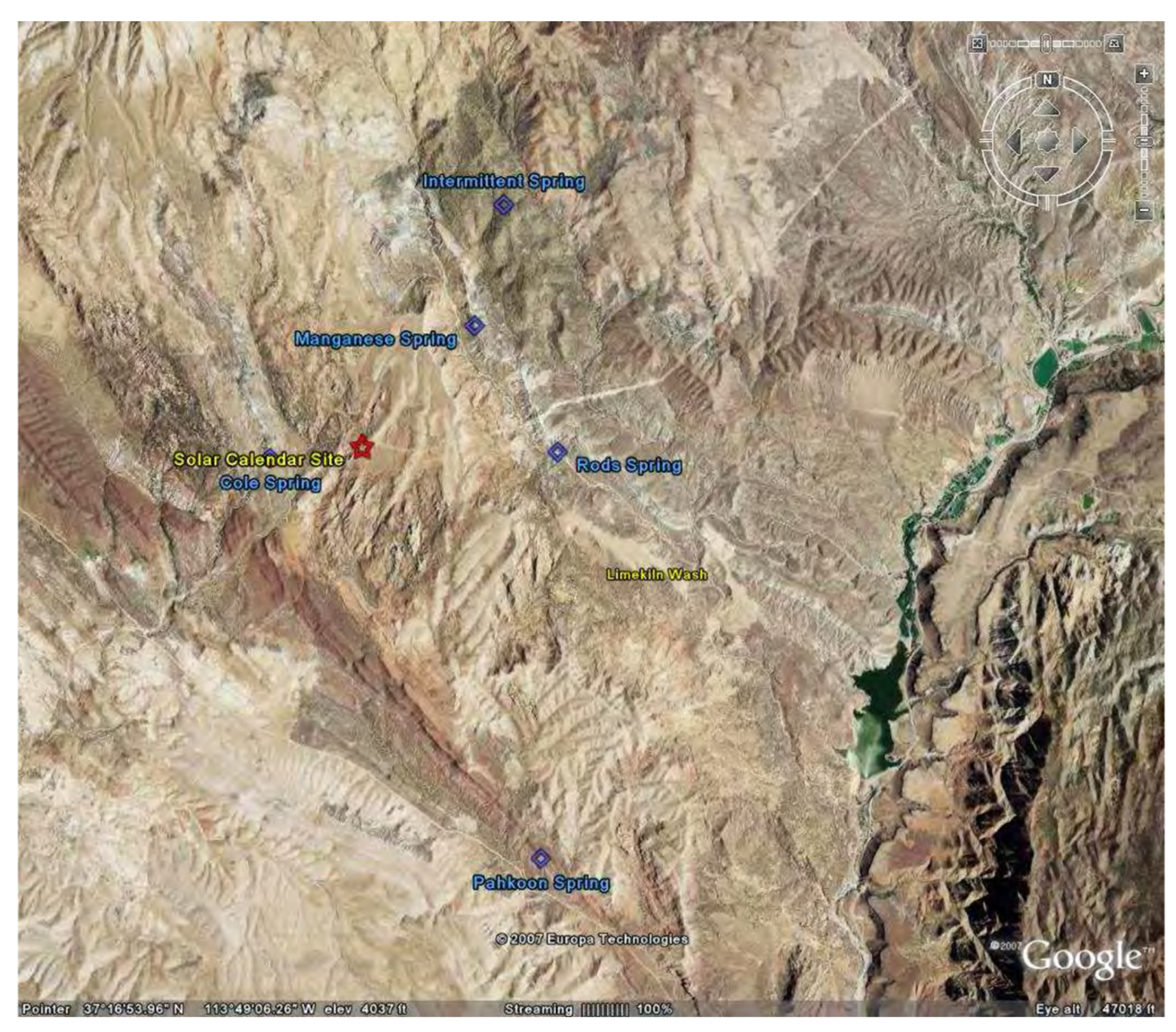
Figure 3.
Sandstone Fin With Solar Cave.
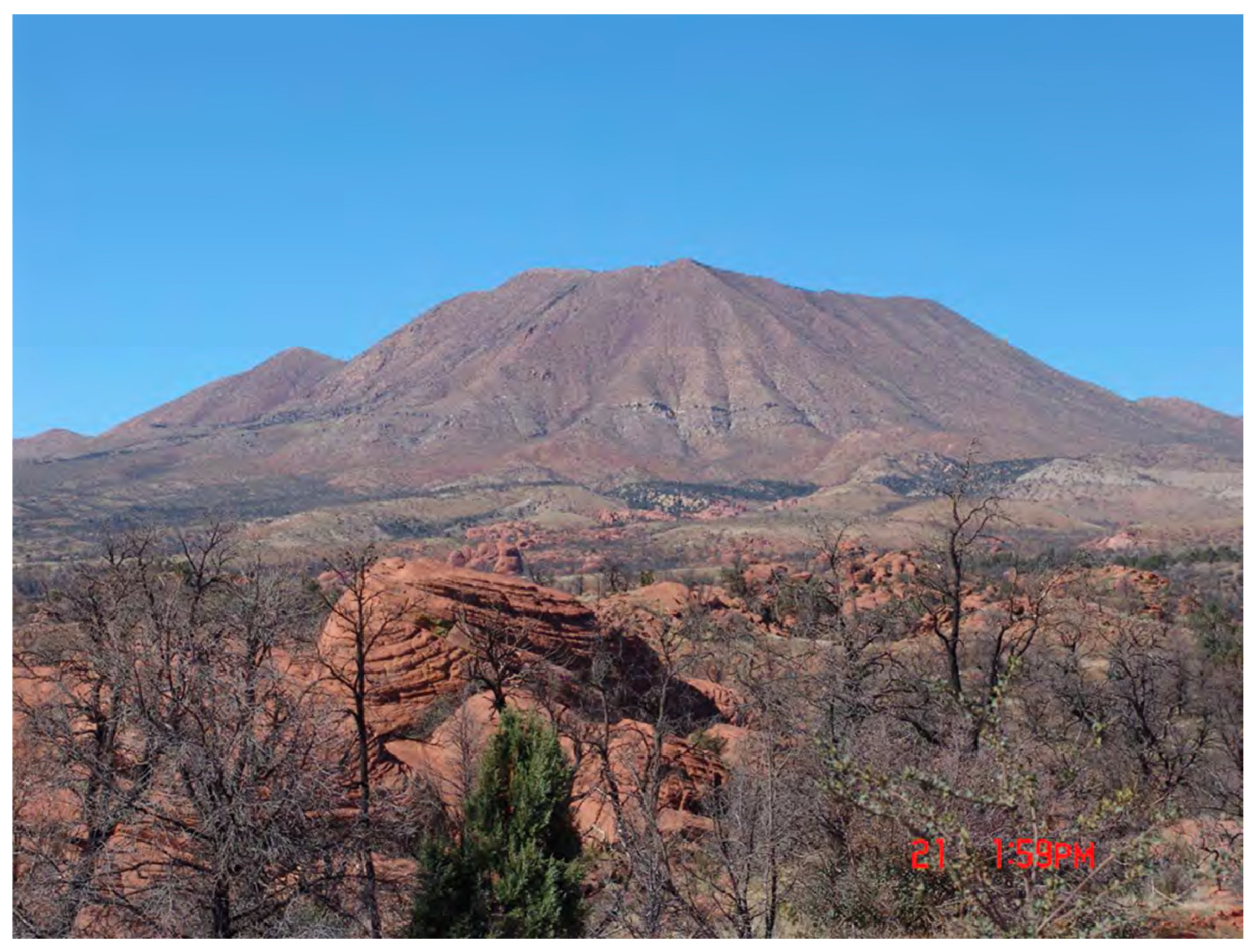
Figure 4.
Shivwits Tribal Representative Viewing Peckings.
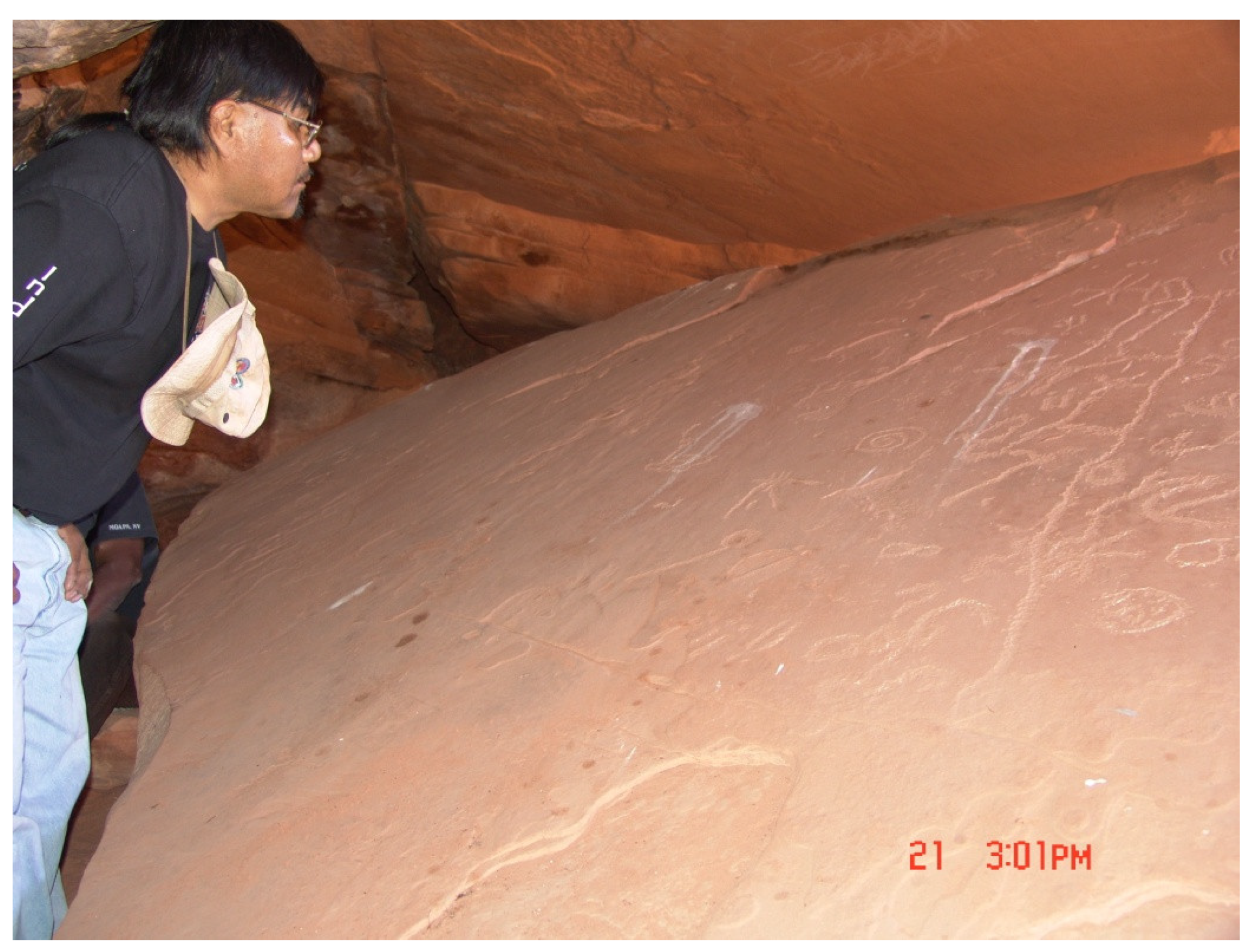
The solar panel is a single large sandstone block that has been lifted and rubbed smooth across its upper surface (Figure 5). On this surface is a single integrated set of pecking most which are touching each other. The midsection of this long slab of pecking is elaborate (Figure 5). The heavy slab has been artificially suspended and perched on the floor of the cave in order to tip it towards the opening of the cave (Figure 6). This new location and slanted angle of the slab permits an exact marking of solar light and according tribal representatives probably times along its outer edge (Figure 7). A carefully crafted crack has been made on the upper edge of the cave entrance so as to permit a narrow shaft of light to fall on the row of groves at the edge of the slab (Figure 8).
A solar calendar this elaborate, and located in a portal this special, would have been at the center of ceremonies for thousands of years according to tribal representatives. This is why Indian people participating in the initial EIS of the powerlines did not identify the sandstone fin, cave, and calendar until they were certain the proposed route would pass immediately in front of this heritage geosite.
It is important to recognize that the solar calendar is perceived as ancient and thus the tribal reprobative argued that it could have had different meanings and uses in earlier times when the Native people had agricultural communities and religious leaders who were tasked with determining the timing of planting and harvesting ceremonies and activities. These farming communities were aboriginally located along the Tonaquint River Valley below the solar calendar, with its fertile riverbanks, was a center of Native irrigation farming from at least 500 AD to 1300 AD (Stoffle et al. 1994). Such large-scale farming and social ceremonies were largely eliminated by diseases beginning with the smallpox pandemic of 1780 (Finn 2001; Upham 1986), subsequent epidemics in the early 1800s, and the dislocations from Mormon Settlers in the mid-1800s (Stoffle, Jones, and Dobyns 1995). Even late in the mid-1800s, the Mormon settlers mapped Paiute irrigation systems including nine complete earthen dams, dozens of beaver dams, and hundreds of laterals that carried water to the fields (Stoffle et al. 1994). The river was a center of agriculture, and so religious leaders charged with assuring the best growing season and the arrival of rain, would gather to assure the accuracy of key times for planting and harvesting. These ceremonies would involve all of the communities in the Tonaquint River (Santa Clara River) and in the Parrussi River (Virgin River) which meet in what is now St. George, Utah.
Mormon settlers arrived in planned expeditions by the hundreds taking Native American farms and dislocating the Aboriginal farmers to places where farming was difficult at best and impossible at worst. Along with disease episodes, religious ceremonies at the Solar Calendar would have become much less complex. It has been documented that some Paiute communities lost 90 percent of their population between 1880 and 1890.
It is not surprising, therefore, that tribal representatives in the ethnographic studies discussed the cave as the location of ceremonies for individual pilgrims. The pilgrimage route began at Veyo Hot Spring to the east. The cave was, as they understood it, was a place for men to go by themselves as part of a pilgrimage. The journeyman (or pilgrim) carved pictures from their journey into the rock. The stories are all in a singular voice (there were no men or people carvings indicating other people’s presence), and the carvings weren’t intended for other people to understand. Only the journeyman would understand his own carvings because they represent his particular journey. The man would camp up in the cave and would bring an offering to the calendar rock. The calendar rock is alive, so offerings would be brought to sustain it. During the 2006 site visit tribal representatives left tobacco in front of the cave, and they left an offering of water to feed its thirst. The need to bring offerings also made the journeyman show his worthiness. It is difficult enough to make a pilgrimage there and then have to climb up into the cave but having to get an offering up there as well (such as water and offerings of plants) makes it more complicated.
The location and purpose of the solar cave is still broadly known by Southern Paiute elders. Dan Bulletts from the distant Kaibab Paiute reservation warned of going into the cave during the 1983 interviews. A professional botanist working with the ethnographic team did so. Inside the rock, he experienced passage through a portal during which everything around him in the cave went from positive to negative, dark to light, and indented pecking became raised peckings. Dan Bullets, a recognized Paiute spiritual leader, culturally counseled this person for much of a year afterward, helping to resolve at some level his portal experience.
Once it is recognized that there is a persistent visual connection between a topographically distinct landscape feature and a proximal time marker, the relationship is tested through frequent use and, if accuracy persists, chosen as a place of preference for human activities associated with temporal moments. Said simply, clocks have to work, and when they do they are kept and protected. When people repeatedly conduct important activities at places, these are commemorated and can become culturally central. Such places can become famous for their temporal services, and thus humans return to such places over generations – some say forever. People do not walk away from or leave unattended such places because world, community, and personal balance is at stake.
8. A Volcanic Heritage Geoscape
The second Storied Rocks case involves a large red cinder cone volcano (Scrugham Peak), on top of a high flat basalt lava flow (Buckboard Mesa), located in the center of a large caldera (Timber Mountain) in a broader region of volcanic events (Figure 9) (Christiansen and Lipman 1977). The edge of the caldera is largely formed by high mountains that were either pushed up during the formation of the main Timber Mountain Caldera or from subsequent volcanic eruptions.
Much of this southern Nevada and eastern California region is managed by US federal agencies such as the Department of Energy (DOE) as the Nevada Test Site (NTS), the US Nelis Air Force as the UTTR, National Parks Service (NPS) at Death Valley, and the Bureau of Land Management (BLM). This analysis was largely funded by the DOE NTS, but three decades of our research in the Amargosa River hydrological system has mutually informed our knowledge of Native American story rocks and environmental adaptations over thousands of years.
The findings presented in this analysis largely derived from the first 14 years of an annual government to government consultation between the Department of Energy Nevada Test Site managers and 17 Native American Tribes. That official consultation was a partnership between the DOE and the Tribes who annually met to discuss ethnographic studies, agency EIS needs, and tribal heritage preservation desires. The tribes organized themselves as the Consolidated Group of Tribes and Organization (CGTO) as to provide a uniform response to the NTS land managers. The consultation is best understood through two documents: American Indians and The Nevada Test Site (Stoffle, Zedeño, and Halmo 2001) and the PhD dissertation on the topic by David Halmo (2001).
Figure 10 is a satellite image of the key geological and heritage places in the caldera: clockwise they area (1) Black Mountain, (2) Water Bottle Canyon, (3) Buckboard Mesa, (4) Forty Mile Canyon, (5) Shoshone Mountain, and (6) Timber Mountain. Lower left in the image is Death Valley. The climate is diverse today but was a massive wetland and forested area in the late Pleistocene and early Holocene. Death Valley in wetter times was filled with water forming the deep Lake Manley, and Forty Mile Canyon was a stream feeding into the Amargosa River. Ancient ecology influenced traditional Native American perceptions and uses of the land.
The high mountains surrounding the caldera drain into a deep canyon created by Forty Mile stream (Figure 11). Water flowing from this canyon is a major tributary of the Amargosa River which flows into Death Valley. During the Pleistocene, all of these places experienced so much rain that the Amargosa River filled Tecopa Lake along its course and Death Valley at its terminus with what is called Lake Manley. Indian people have been in the Amargosa River hydrological system for at least 37,000 years. During this period, this massive drainage was filled with megafauna, abundant flora, and many topographically distinct features. It remained so throughout the late Pleistocene and during much of the Holocene when the climate became dryer and colder so many animals and plants could no longer occupy the region, but Native Americans adapted and remained. Most of the Storied Rocks in the Timber Mountain Caldera are centered at Buckboard Mesa.
One of the most striking characteristics of Storied Rocks on the Nevada Test Site are their abundance in the Timber Mountain Caldera, especially on and around Buckboard Mesa (Figure 12). According to the Native Americans, places of great significance for vision questing and ceremony were localized around Buckboard Mesa and Scrugham Peak because these were volcanic areas (Stoffle et al. 2001; Stoffle, Van Vlack, Arnold 2005; Stoffle et al. 2006; Zedeño et al. 1999: 155). These volcanic features are a perceived source of power and are seen as the geographic and sacred center of the area. The power emanated from the caldera and Buckboard Mesa provided and furnishes power to all associated Earth elements. It is not surprising to them, therefore, that Storied Rock sites such as Buckboard Mesa (north and south) and upper Forty Mile Canyon are located near this center.
Historically documented areas to the northeast, such as Wunkiakuda near Ammonia Tanks (Steward 1938: 94 -95), are now understood from ethnographic interviews as a ceremonial area focused on a tonal canyon, a massive solar calendar area, a rights of passage area with bow trees, and a massive white stone portal (Stoffle, Van Vlack, and Arnold 2005). The trails indicated in red on Map (Figure 13) are largely formerly pilgrimage trails to Wunkiakuda.
The information in Table 1 is a summary of tribal assessments of the purpose of Storied Rock at ten locations in the central caldera (see Figure 13). Buckboard mesa has hundreds of rock piles located near the peckings. These are documented stone constructions that have been interpreted as Vision Questing cairns. Each category of purpose identified in the table involves a question on the Rock Art interview instrument. The responses are organized by gender. The Storied Rock markings, some of which are illustrated later, varied widely among the ten locations both in terms of design, and number of markings. Some places like Cot Cave had only a few markings while the Buckboard Mesa had hundreds including many vision questing cairns. Stones, even if they were neither pecked nor painted, were moved and modified at all locations.
Table 1 presents the findings from ethnographic interviews with tribal representatives. Their responses are organized by (1) Story Rock Location, (2) Kinds of Uses, and (3) Gender of the Respondent (Zedeño et al. 1999).
The ten Storied Rock places in Table 1 were each culturally understood by the tribal representatives interviewed at these locations. The interview forms structured only the kinds of responses, but open-ended knowledge sharing was common. Clearly, some places were for ceremony while others were to teach other ethnic groups or youth who were being prepared for medicine, spiritual communication, or leadership. Knowledge was sought in places like the Power Rock but not nearby at Eagle Rock. The responses were thoughtful with up to three hours devoted to understanding (which involved talking with the Storied Rocks location) and interviewing at each location. Almost always there were different understandings for women and men. These data clearly support the theory that the Storied Rocks are all about the place where they are located.
8.1. Buckboard Mesa Pilgrimage Trail
The Pilgrimage Trail to Buckboard Mesa could be termed as it is in the map above the Trail to Scrugham Peak, given it is this volcanic peak is the highest point in this central portion of the Timber Mountain Caldera. Another pilgrimage trail, however, leaves the main trail and goes to the top of Shoshone Mountain. Both pilgrimage trails begin and end at the same location. Figure 14 presents a map view of the Story Rock sites profiled in this analysis. Relationships between the center point at Buckboard Mesa and surrounding Story Rock areas studied by tribal elders vary in a number of important ways such as (1) geology, (2) size, and (3) distance between the starting point at Tippipah Spring and at the mesa center. Interestingly they are all on the pilgrimage path or geotrail (Stoffle et al. 2001; Stoffle et al. 2006; Zedeño et al. 1999). There is no proximal Story Rock sites located away from the two divergent pilgrimage trails, which further argues that these are geotrails; that is, designed to ceremonially connect geologically special places.
A formal Rock Art interview form was developed with the CGTO in the late 1990s to help achieve systematic data collection during Storied Rocks studies (Zedeño et al. 1999). It was used again during the Shoshone Mountain study (Stoffle et al. 2001), the Water Bottle Canyon study (Stoffle, Van Vlack and Arnold 2005), and the Timber Mountain study (Stoffle et al. 2006). Thirty tribally appointed representatives who were interviewed during seven field studies conducted in 1997 and presented the 1999 Story Rock study report. Each subsequent study had tribal representatives. Questions reflected culturally important topics developed during successful interviews with representatives of consulting tribes. The ethnographic field interviews also were guided by rock art site documentation by professional archaeologists working at the Desert Research Institute, University of Nevada, Las Vegas.
Tribal representatives participated in designing the methods by expanding the range of site studies, the questions asked at each site, and the time spent interviewing at each location. These changes in methodology occurred as tribal representatives better understood the focus of Storied Rocks studies. Interviews occurred with different tribal representatives and were often conducted during seven field sessions. The University of Arizona research teams were guided by three professionals with PhDs in anthropology and supported by a PhD in archaeology from Desert Research Institute. Each representative was afforded a confidential interview with a trained ethnographer and given the right to review and approve the summation of their interview before it was reported to the NTS DOE land managers.
The Buckboard Mesa Pilgrimage Trail extends from (1) Tippipah Spring as a ceremonial starting and ending point (see Figure 14). The pilgrim trail goes next to (2) the first Geoglyph, then to (3) the Doctor Rock, next to (4) the Mushroom or “Eagle” Rock, and to (5) upper Forty Mile Canyon at Rice Grass Village and the large “Map Pecking” of the Buckboard Mesa area. From here the whole surrounding Upper Forth Mile headwater area is documented as being for ceremonial use. This area includes (6) the second geoglyph area, (7) the volcano basalt boulders, access to (8) the top and sides of Buckboard Mesa and Scrugham Peak. All Storied Rock places along the geotrail have ethnographically identified portals to other dimensions. These portals, however, differ in structure, protocols, and where they take the pilgrim.
8.2. Geosiste 1: Tippipah Spring
Tippipah Spring is a strong permeate source of water largely derived from Shoshone Mountain to the southeast of the spring (Figure 15). As a reliable source of water in what is an extremely arid caldera today, the spring was a center of Native American activities. While a few Native people lived at the spring full time, it is better termed a Ceremonial Support community rather than an agricultural community. The latter were located in Oasis Valley to the west, further south along the Amargosa River, along the Las Vegas River to the southeast, and along the edge of the Colorado Plateau. Primary agricultural rivers located here were the Pahranagat or White River, Moapa or Muddy River, Tonaquint or Santa Clara River, Mukuntuweap or Virgin River), and Colorado River. Each irrigated agricultural community along these rivers would have had at least 300 residents according to observations in the mid 1700 to 1800s.
Residents at the Ceremonial Support community, as was the pattern throughout the west, central America, and the Andes of Peru (Bauer and Stanish 2001). Their responsibility was to take care of ceremonial paraphrenia, ensure that ongoing prayers are conducted, and provide food for pilgrims. Ceremonial paraphrenia are event and location specific and are stored in shallow rock shelters which are often walled up for protection. These paraphrenia cannot be taken back to residential agricultural communities because people there should not be exposed to their power. A hidden ceremonial paraphrenia storage area was found near Tippipah Springs in the mid-20th Century despite the site being lost to Native control during the middle 1800s when a series of trails were converted into a wagon road, a stage stop was established, and predatory miners occupied all spring during the 1904 gold rush of Oasis Valley. The ebb and flow of non-Native water users opened opportunities for the traditional Native people to return to the spring and the area for ceremonial activities. Portions of area just north of the caldera however were better suited as regions of refugee such as Water Bottle Canyon, which was used for this purpose when USGS surveyors marked its location in 1906 placing the valley and Native trails to it on the first USGS map of the area.
Tippapah Spring does not contain Storied Rocks. It has a different function, being the place where pilgrimages to story rock geosites begin and end their journey. Other springs in the broader area have ceremonial functions.
8.3. Geosite 2: The First Geoglyph
The first geosite after leaving Tippapah Spring is a Geoglyph. This site has been extensively studied over time because of its charismatic features and being near Tippapah Spring which is a central watering and stopping location (Figure 16). Closer to the NTS, several geoglyphs are located in the Mojave Desert, and in fact, many are found near the Colorado River with Blythe Intaglio being the most famous. This geoglyph was discovered in 1931. The Blythe Intaglio depicts several characters, one of which is Mastamho, the Creator of the Earth, and two mountain lions that helped him. Sacred ceremonies were held here to honor Mastamho (BLM 2005).
Geoglyphs were considered very important to the Indian people along the Colorado River who often use the designs in connection with religious ritual, dancing on the lines as if they were paths. This is an important point because geoglyphs and trails are connected. In fact, geoglyphs in the southwestern United States are thought to forge a spiritual link to trails (von Welhof and Casey 1987).
The Geoglyph One site impressed Wheeler, an early archaeologist, so much he identified it as a ceremonial area. He further described the patterns of cobbles as appearing to be creating walkways leading into circles, perhaps for dances or other rituals. During his excavations of the site in 1940, Wheeler uncovered yellow ochre, or Limonite, which is a very important paint source. The source of yellow ochre is located near this area and was probably brought in by Indian people to use in ceremonial activities. Artifacts such as chert and obsidian drills, bifacial scrapper, silicified volcanic knife, ground stone, pottery, and fire hardened juniper sticks were found and removed from the site by Wheeler (Wheeler 1940, Winslow 1996:154-159).
Based on our new interviews in the Timber Mountain study (Stoffle et al. 2006) it was concluded that after leaving the settlement at Tippipah Support Village and Spring, pilgrims traveling both Puha Path I and Puha Path II would have arrived at the Geoglyph One. This site is located 3.5 miles from Tippipah Spring in a small and heavily dissected valley. It would have been the next logical stop along Puha Path I before reaching the Doctor Rock, and also along Puha Path II, which diverges from the shared route and leaves the Geoglyph One for the Ceremonial Rock Shelters.
Another elder noted that the geoglyph is connected through the volcanoes, through a power spot, by having everything you would need. They would have cleaned themselves at the hot spring in Beatty before coming up here. It is a well-used area. They had to spend a lot of time together and they came here to do that.
This idea [for the geoglyph] could have come from far away. The idea here is that someone can see it from above. It was to talk to those above. The [geoglyph] could be seen from the top of the volcanoes to the south. You could see the area and know about it. We need to go to the top to see what alignment with Scrugham Peak. People could put themselves in a trance and go quietly from one area to another go miles and just be there very quickly. That is an Owens Valley story from an old person who was told it by his grandfather. They could travel without using much energy. There were people used for sending messages. Most of the people who traveled could do that. The mind can do many things. It is capable if you use it right.
According to one elder, the geoglyph area could have been used while people were en route to another location. People would stop here on the way to other places. Many respondents suggested that this area was a stopping point on the way to other sites connected to this one.
8.4. Geosite 3: The Doctor Rock
After passing through Geoglyph One, Indian people traveling along Puha Path I would have walked 2.93 miles to come to this location (Stoffle et al. 2005). The Doctor Rock geosite contains several cultural features: (1) two large boulders covered with peckings lie by the roadside at the bottom of a drainage; (2) a small rock shelter and artifact scatter in front of it are across from the boulders on the south side of the road above the wash, and are marked by cairns; and (3) a large flat boulder with a hole in its center and a smaller rock staked under it are located on the ridge top just above the petroglyph panels (Figure 17).
For this analysis, only the Doctor Rock is being discussed because it is defined as a portal for doctoring and travel of religious and political leaders.
There is evidence that the Doctor Rock itself has been moved to this location according to tribal representatives (Figure 18). The component materials of the Doctor Rock are not otherwise present at the location. The Doctor Rock is located on a high point at the junction of two intermedial streams. Another stone panel that is both large and fully covered with peckins (6 feet by 5 feet)is located down slop from the Doctor rock on the side of the hill. This panel was uniformly and independently interpreted by the oldest tribal elders as the location of intertribal meeting from cultural groups throughout the region. A small structure across from the Doctor rock was interpreted as a place for storing ceremonial materials that were too powerful to be taken back to normal residential areas.
Once it was moved to this location it was perched onto a large stone (Figure 19). The large stone itself is covered with desert varnish indicating that it too was moved to this location to become a part of the ceremonial components of the Doctor Rock. The portions of the supporting stones that are covered with desert Varnish are under the Doctor Rock and thus not exposed which would have been needed for the desert varnish to occur.
8.5. Geosite 4: Mushroom (Eagle) Rock
Eagle Rock, also called Mushroom Rock, is a large, isolated, welded tuff boulder named after its shape (Figure 20). The site is along Forty Mile Wash at the base of a ridge extending from Shoshone Mountain and close to the Doctor Rock site, which is 0.9 miles to the west (Zedeño et al. 2005). The top of the formation contains petroglyphs; associated archaeological remains are found underneath the petroglyphs and in the rock’s immediate vicinity (Jones and Drollinger 1997: 26, 28). Evidence of this site’s use along Puha Path I is suggested by a rock ring, ground stone, and many artifacts, both prehistoric and historic scattered beneath it (Zedeño et al. 1999). Because of the mushroom-like shape of the boulder, it likely provided shelter. Like the Doctor Rock site, pilgrims would have used Eagle Rock as a prayer and preparation area. Interpretation of the site and peckings were difficult for the elders in as much as the USAF used it as a target for fighter plane shooting practice. These actions broke a major portion off and disrupted the integrity of the peckings.
In 1997, Indian tribal representatives deemed the Eagle Rock very sacred and an ethnic marker (Zedeño et al. 1999). The site was interpreted as a place for medicine and the performance of ceremonies. Tribal representatives also believed it was a teaching site for young boys to learn about the ways of medicine.
In summary, of 22 elder interviews conducted at this geosite, Eagle Rock was used to teach young boys how to clean out water tanks, how to perform medicine, and how the patterns of the stars will guide a person in their travels (Stoffle et al. 2006, Zedeño et al. 1999). It was also found that it was a landmark through which people would have recognized and talked about the land. The shape of the rock is like that of an eagle, which is a sacred bird. Also here are large amounts of obsidian and extensive rock pecking covering most surfaces. Obsidian could have been left by pilgrims as offerings along their journey. These features and artifacts indicate that this is a culturally special place that was used for medicine and ceremony.
8.6. Geosite 5: Upper Forty Mile Canyon
Upper Forty Mile Canyon is steep sided area defined by its headwater at the northwest slope of Buckboard and by the northeast margin of the Timber Mountain resurgent dome. The photos (Figure 21) below are from the headwater of the watershed looking southwest towards Shoshone Mountain. The edge of Buckboard Mesa is left with a Red-Tailed Hawk flying overhead. The right side is the edge of the resurgent dome. The bottom of the canyon is white sand. A rock shelter called Big George Cave is visible near the eastern side of the wash approximately halfway to the headwater divide to the north.
By 1999 DRI had undertaken systematic field research that greatly expanded knowledge of the extent, content, and significance of this area (Zedeño et al. 1999: 47). Based on diagnostic projectile points and pottery, they estimate that the area has been used for the last 9,000 years (Jones 1996: 15). About 440 boulders displaying almost 3,000 individual petroglyphs are found in various concentrations throughout the site.
At the entrance to the headwaters of Upper Forty Mile Canyon is a small spring and a large volcanic boulder with large peckings on one face (Figure W). Elder interpretations of the entrance boulder peckings were largely in agreement that it was a map of the area and its culturally important places.
Figure 21.
Boulder at Entrance to Upper Forty Mile Canyon with Map Pecking to right.
Given the location and style of the entrance, bolder peckings elders identified the rock as a map guiding pilgrims to the ceremonial places in Upper Forty Mile Canyon. Key interpretations were provided by Clifford Jake. He often used an old style High Chief language which was understood by the study linguist David Saul. In the upper right portion of the pecking is a snake image and later in this analysis we discuss Forty Mile Canyon as being either a snake or created by a snake.
8.7. Geosite 6: Second Geoglyph
The second geoglyph is located near the map rock and spring and is visible in two images in Figure 22. The geoglyph was interpreted as functionally the same as the one near Tippipah spring. This one however lacks the long apparent entranceways and consists of a circular rock alignment with two appended semicircles (Zedeño et al. 1999: 47). The circles are clearly visible and do not appear disturbed (Jones 1996: 27). One Pinto point and one Rosegate point were recorded in this area (Jones 1996). Desert Side -notched projectile point and an unidentified dart also found in this area suggest dates of 1,200 BP and 1,500 BP, respectively (Jones 1996: 25).
8.8. Geosite 7: Basalt Boulders With Peckings
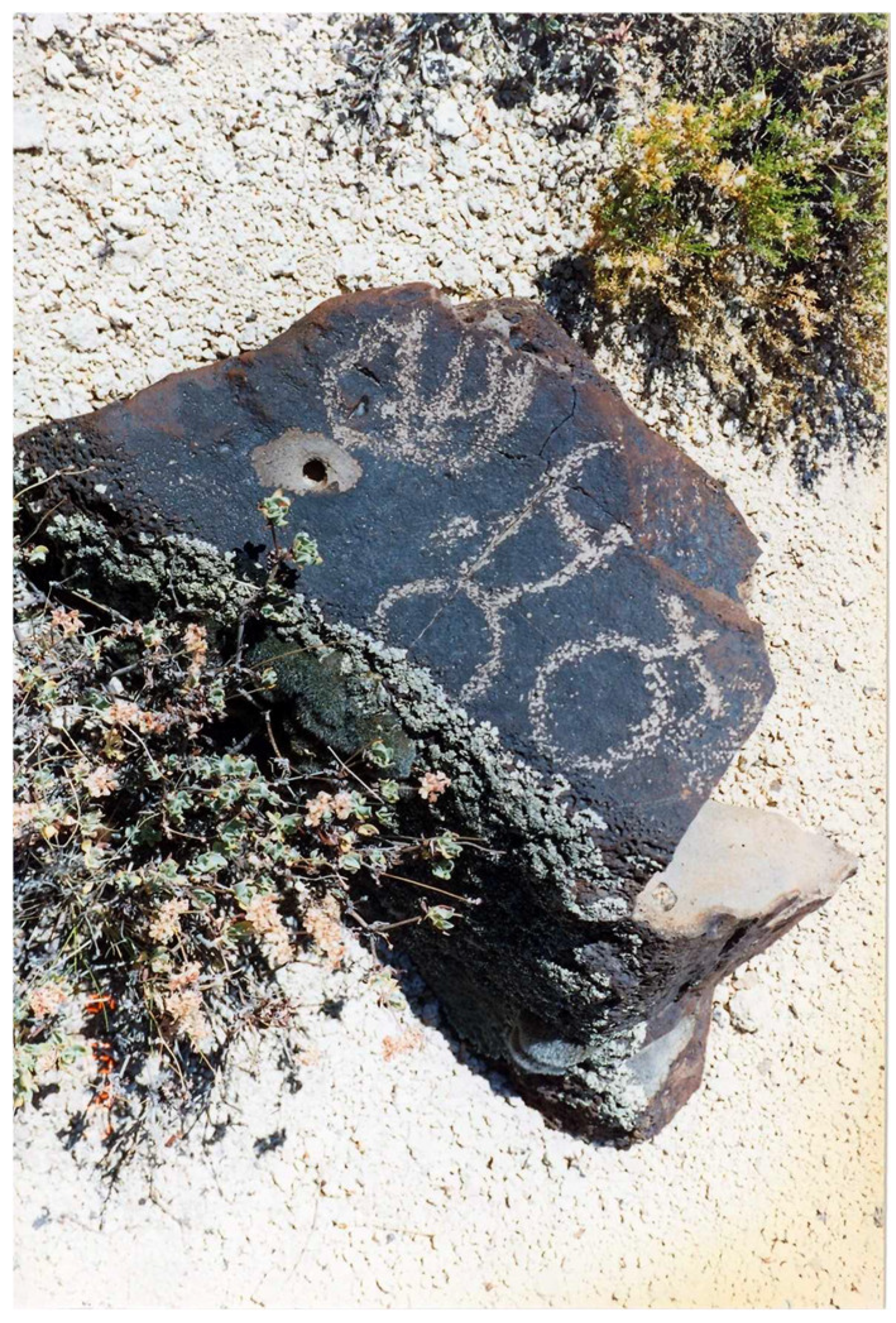
In Upper Forty Mile Canyon there are hundreds of boulders, each with a pecking and most with a rubbed grinding area (Figure 23). The stimulus for the peckings were generally interpreted as being associated with vision questing. There was, however, some discussion of whether or not the visions were acquired in Forty Mile Canyon or were recorded there after being experienced on Buckboard Mesa and Scrugham Peak.
Rock cairns on the mesa and peak were interpreted as a record of visions, but a discussion was open as to whether or not the visions pecked on the boulders below in the canyon could actually serve as a portal for another person to the same vision. Many boulders had parallel dots on them which have been widely interpreted as evidence of an entopic state. The questions remain as to whether this dream state is an experience in the same body and place or something occurring in another dimension. There was no clarity on this issue, however a number of boulders had modified holes in them. Such holes have been documented in a number of studies involving portals as where pilgrims enter another dimension by placing their finger covered with red paint in the hole.
Figure 24.
Basalt Boulder With Peckings.
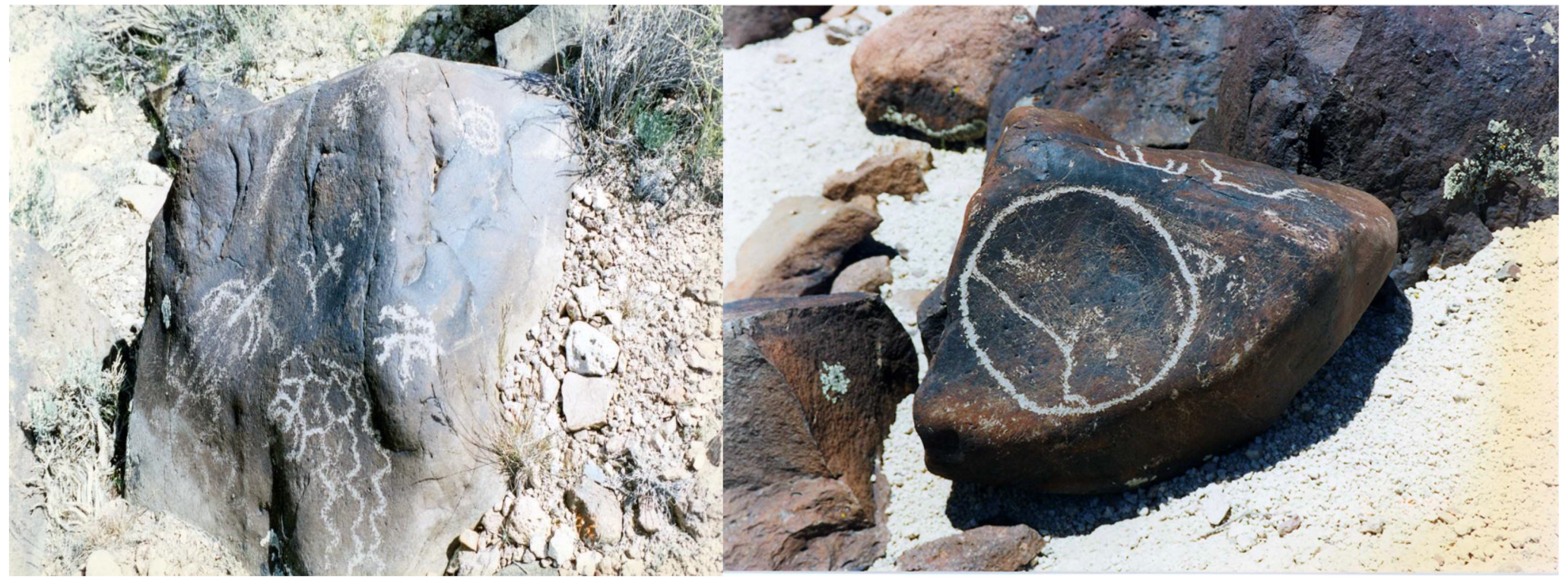
Figure 24.
Basalt Boulders with Peckings.
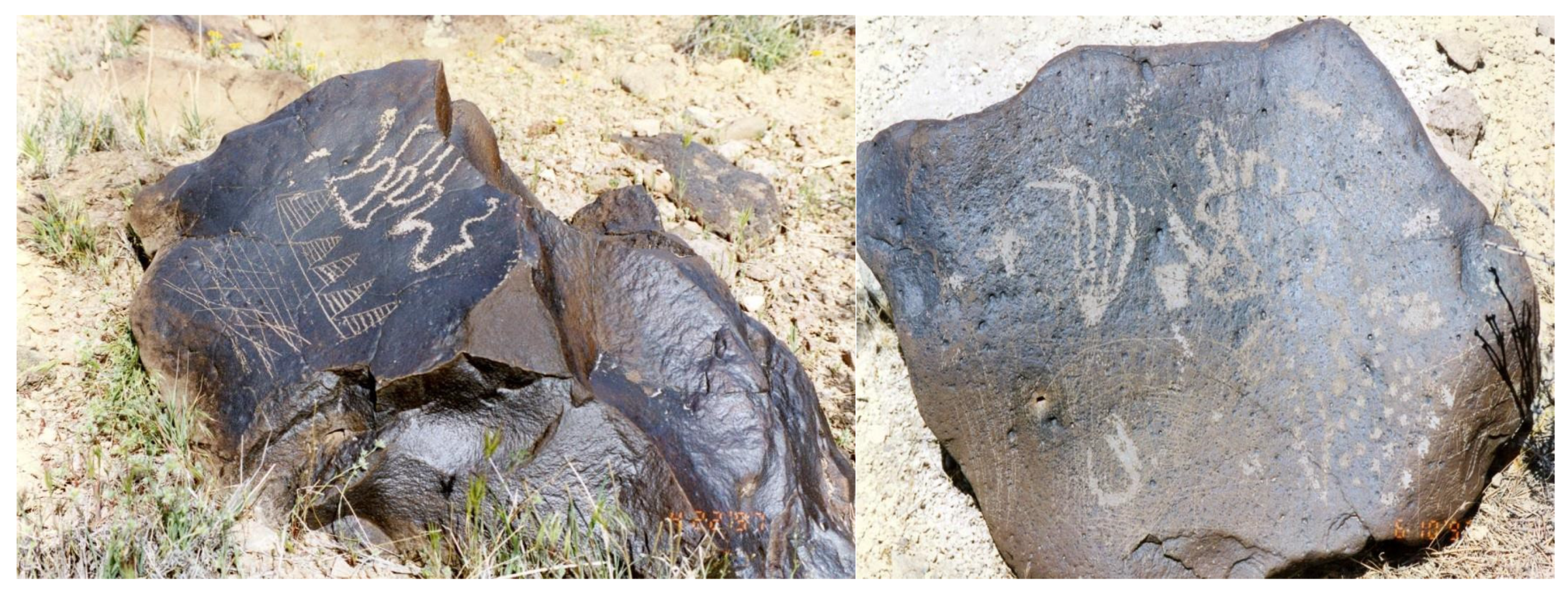
Figure 25.
Basalt Boulder with Modified Hole for Entrance into Another Dimension.
A summary of upper Forty Mile Canyon Storied Rock locations, that is based on about 35 formal interviews and many informal discussions document that all Native American tribal elders felt a strong ancestral, cultural, and historical relationship with upper Forty Mile Canyon (Zedeño et al. 1999:55)
When asked why the petroglyphs were made and how were they were used, tribal elders offered the following answers, in order of frequency:
- * Ceremony
- * To seek knowledge or power
- * To map resources
- * To communicate with spiritual beings
- * To communicate with other Indian people
- * To teach other Indian people
- * To pay respects
- * To mark their territory
At the most general level of abstraction, the Storied Rocks in this area were viewed as places where people of different ethnic groups would have come to conduct ceremonies. People would have known how to read the entrance map to know where resources occur as well as for proper sites for religious activities.
8.9. Geosite 8: Buckboard Mesa and Scrugham Peak
The tribal representatives generally agreed that the top of Buckboard Mesa and associated Scrugham Peak were places where visions were sought and found by Native specialists (Figure M). The mesa and peak are directly observable volcanic features and thus would have been sought out for their special energy and spiritual powers (Stoffle et al. 2005, Stoffle et al. 2024, Zedeño et al. 1999).
These areas are the primary destination of the geotrail from Tippipah Spring; however, geosites along the trail were at least their own ceremonial places in and of themselves. The ethnographic data documents the use of rock piles or cairns to make places where vision quests were successfully conducted. These cairns line the rim of Buckboard Mesa and along the flank of Scrugham Peak. Associated with the basalt rim are peckings that either expand the stories of the cairns or convey another related story altogether. Buckboard Mesa and Scrugham Peak are considered one place by Indian people and are connected through ceremonial activity.
The mesa rim is a 66 to 99 foot high basalt cliff extending around the entire circumference of the mesa. Located there are natural ledges and rock shelters where Desert Research Institute archaeologists found evidence of previous Indian use (Pippin and Henton 1991). Additionally, archaeologists have recorded artifacts and built features located on top of and along the southwest rim of the escarpment directly overlooking Big George’s Cave. These resources include a 3,300 foot horizontal alignment of rock cairns on the edge of the mesa, spatially associated with boulders displaying rock art, large rock art panels on the escarpment below the edge, a milling stone, a possible rock wall, lithic scatters. Cairns are small piles of rocks spaced at approximately regular intervals and extend 1,650 feet in each direction of the natural staircase to the mesa surface (Jones and Drollinger 1997:20).
Buckboard Mesa placed in a geological context is unique (Lutton 1968). It is a massive basalt lava flow located between the east and west headwaters of Forty Mile Canyon. It largely emerged during a single volcanic flow. It is 5.5 miles long in a generally trending northwest direction. It is about 2.5 miles at its widest and narrows to a point in the south. Emerging from the surface of the mesa top is a 400-foot-high cinder cone called Scrugham Peak (Figure 26).
The mesa basalt probably emerged during the final stage of caldera subsidence in the Pliocene or Pleistocene. Surrounding the mesa are deposits of sandstones, breccia, and water worked pumice, all being indicators of an extensive fluviatile environment in the Forty Mile flanks of the emerging mesa (Lutton 1968).
Scrugham Peak is composed of red cinders which are scattered over the basalt, some of which emerged during the eruption of the cinder cone. The cinder cone contains magma dikes, and its top depression was filled in with magma creating cumulo dome (Lutton 1968). This is an important feature of the peak in as much as the basalt in the peak has given it stability in the face of atomic tests on the mesa.
A critical variable in the Native American representative’s interpretation of the mesa and peak is a series of nuclear and high-explosive cratering experiments that were conducted in the basalt capping Buckboard Mesa by the U. S. Atomic Energy Commission Nevada Test Site from 1960 through 1966. It is understood that some of the vision quest cairns were collapsed as a result of these explosions. The map in Figure 27 illustrates the latticework of roads on the surface of the mesa.
A general consensus expressed by one tribal representative is that: they would have camped below the mesa top but then came up here to do their spirit-seeking. They had to be in a group. The seeker needs helpers. There were no women in these camps. The rock piles were where they stayed to seek their vision and get medicine. The people who received the medicine made the rock piles (Figure 28 and Figure 29). The later ones would use the same piles, and it was reused for thousands of years. All the peckings were made for the same reason - this is a power place.
One of the panels that had a profound impact upon the Native American representatives was the “three legged” anthromorph (Figure 30). Representatives strongly believed that it is linked to vision questing ceremonies. The panel was also interpreted as representing a spirit helper, perhaps a lizard. Pilgrims might have interacted with that panel and acquired a spirit helper to assist them in the last segment of their journey along Puha Path I to the top of Scrugham Peak.
The sacredness of the mesa top and rim is represented by other peckings such as the scratches just under the mesa edge (Figure 30). This pecking was further interpreted as powerful because it is home to Indian Tobacco that grew out of the cliff face.
Below the edge of Buckboard Mesa, youth, probably mostly boys, were taught to talk with, work with, and form together tools made from obsidian nodules. Large areas of such nodules occur just to the northeast of Buckboard Mesa where fist size obsidian nodules can be found in abundance.
During the 1996 NAGPRA consultations, Native American representatives commented on a traditional use feature at the northern base of Buckboard Mesa (Figure 31). At this location, there are a series of rock shelters that were associated with an obsidian nodule tool stone source area or quarry and extensive lithic scatters. Numerous rock shelters associated with petroglyphs indicate that this area was used in prehistoric times. Seven obsidian points were selected from this site. Interpretations given for this place exemplify how activities such as raw material procurement, tool making, and hunting are viewed by Indian elders as sacred, all because the ceremonies involved were close to the petroglyph. This is a power place located on Buckboard Mesa. Native American representatives associated this area as a place where boys would learn to knap obsidian and make arrow points as part of rites of passage ceremonies (Stoffle et al. 1996).
Along the edge of the mesa, near the obsidian training location, are peckings. A portion of one panel is in Figure 32 As a part of this panel is another rattlesnake image and a snake symbol. The pecked circles were interpreted as entrances into other dimensions.
Tribal representatives studying and interpretating these locations said they represented locations with artifacts that should be returned to the tribes under the Native American Graves Protection and Repatriation Act (NAGPRA). They qualify as both objects of cultural patrimony and sacred objects that should not be removed because they are part of an ongoing ceremony as a link between the ceremonial participants the living volcano.
8.10. Scrugham Peak
This volcanic cinder cone mountain was the destination site for those traveling for a vision (Figure 33). Native American representatives believed that seeking visions and learning medicine songs and practices occurred on the peak. They would have used Puha acquired during previous visits to the various petroglyph panels. Numerous rock cairns are located on the western side of the mountain (Figure 34) and these cairns were used in ceremonial activities by the pilgrims, who would ascend to the top of Scrugham Peak and stay for a number of days and nights until their vision had been achieved.
The ceremonial experience occurring on the top of Scrugham Peak involves being 400 feet higher in elevation and having a broad view of the surrounding landscape (Figure 35). In general, higher elevations are significant components of vision quests but can also be critical to ceremonial leaders who are sending prayers to other locations. The rock cairns on Scrugham Peak are similar to those elsewhere. The presence of circular rock walls however on the peak and scattered along the rim of Buckboard Mesa led the tribal elder believe different kinds of ceremonies were involved at these differently marked Story Rock locations.
The notion that Scrugham Peak involved (and may involve again) cultural activities on a volcano that is located on top of another volcano did not pass without mentioning the significant of having the power of each volcano added to the other. In general, powerful living beings whether plant, animal, or geological are attracted to one another and see each other out.
8.11. Origin Stories and Geoscapes
American Indian consultants offered additional comments regarding the existence of songs and song trails associated with upper Forty Mile Canyon (Zedeño et al. 1999). This information suggests that there may be a geotrail that ties different songs to specific locations in the area. Indeed, one Southern Paiute elder recalled having received a song - -his song -- during a visit to the NTS area. Similarly, at least one oral tradition, which refers to Snake as the creator of Forty Mile Canyon, also indicates the existence of storyscapes.
According to a Western Shoshone elder, the origin story of Towahonupi or Forty Mile Canyon was created when Snake went through this place, traveling from Oasis Valley to Beatty, and then to Bear Mountain, where he is resting now. When Snake was traveling, he made the canyon. So, the canyon is named after him. Snake is tokoa in Western Shoshone. There are many petroglyphs here that talk about Snake. That is why this place is so dangerous. People should not stay here too long or disturb the area. This Shoshone origin story was also collected during the Yucca Mountain research. Water babies and Mountain Sheep also have resource-specific stories that serve an important role in tying places and resources to larger cultural landscapes.
9. Discussion
The analysis of Storied Rock geosites and geoscapes in these two cases documents the complexity of both. The geosite solar calendar is in a single isolated rock cave. It appears to be unrelated to nearby places and was its own designation. The Buckboard Mesa geotrail is situated in a massive caldera that is filled with culturally complex and functionally interrelated geosites. It is clear from these studies that Storied Rocks considered in this analysis:
- Cannot be understood without reference to the cultural meanings of heritage locations where they occur.
- Cannot be understood without reference to geosites connecting them as functionally interrelated components of geotrails and geoscapes.
- Include modified but not marked stones like cairns and moved stones like the Doctor Rock and the calendar rock.
- Mark the traditional meanings of places.
- Mark the location of paths to other dimensions (that is portals).
Left unanalyzed so far in this essay is an epistemological divide regarding the existence of Visions and Portals. At some level in western epistemology, visions occur when the body remains in place and the mind imagines something else. We hesitate to use the term Dreams and Liminal State because both exist as an out of body or through the body elsewhere experience.
Take traditional Native runners who were full time specialists moving information for religious or political leaders. They were widely known to move toward their destination and after a short distance disappearing and leaving no footprints. The runners arrived at their destination when they left. They moved at will in space and time without either elapsing.
One of the earliest ethnographic discussions of portals occurred during a research trip with Paiute elders down the Colorado River through the Grand Canyon (Stoffle et al. 1994). On a high ridge above the river was a three-foot round stone having many deep pockets. Our ethnographers were told not to place our fingers in the holes for we would subsequently move into another dimension and without help might remain there. It was the beginning of many dozens of warnings by elders not to place our fingers and hands into stones, cliff faces, and circles on hilltops (Stoffle et al. 2016). A very few of these Storied Rocks locations are discussed in this analysis, but the pattern is so prevalent in Native culture that it is a common safety warning.
During the Southern Paiute funeral, two lines of singers face one another while family, friends, and community members dance the deceased’s clothing, pictures, and other articles in an oval (Stoffle Personal Experience). At various points during the two days of singing, the lead singer halts and does not seem conscious. He breaks the silence with a report that the deceased is at a known point along the Salt Song Trail where the singer just talked with the person asking how they are faring in the 1,000-mile-long journey to the afterlife. At the end of the many sets of sequential songs, the deceased has been moved to the afterlife and the lead singer visits and observes that s(he) is fully healed and happy to be with all of his formerly departed relatives. The next morning after the burial the deceased assumes the body of an animal and visits a family member to talk with them about the success of the journey and his (her) appreciation for the family, friends, and community members singing her (him) to the afterlife. For a year the discased visits relatives in shared dreams.
Vignettes such as these document the existence of portals to other dimensions but certainly cannot resolve the epistemological divide these present to those with differing beliefs in the structure(s) of existence. The existence of portals in Native culture and the knowledge of where they occur and how to interact with them structures Storied Rocks made or erected to guide or assist the pilgrim on their journey through the portal and back.
Author Contributions
The authors of this research analysis made equal contributions to the conceptualization, data analysis, document reviews, and writing of the current paper. All authors have read and agreed to the published version of the manuscript.
Funding
The research this essay draws from was funded by a number of United States federal agencies such as the Department of Energy, the Department of Defense, the National Park Service and the Bureau of Land Management. This research was funded over the course of three decades.
Acknowledgments
Funding for the ethnographic studies that contained a focus on Storied Rocks included (1) National Park Service, (2) Bureau of Land Management, (3) U.S Forest Service, (4) US Airforce, (5) US Army, (6) US Department of Energy. A dozen tribal governments chose to participate in these ethnographic studies but especially notable are the tribes of Arizona, California, Nevada, New Mexico, and Utah. Special thanks for the hundreds of elders who trusted our study team to listen, record, and appropriately write up their cultural understandings. Parallel with the elders were university students and alums knowing that the best they can do is to be a respectful listener in the file and to work for many hours more to transcribe, edit, and integrate the many interviews into a text that will be read closely, understood, and respected by land managers.
Conflicts of Interest
The authors declare no conflicts of interest.
References
- Bauer, B. and C. Stanish. 2001. Ritual and Pilgrimage in the Ancient Andes. Austin, TX: University of Texas Press.
- Christiansen, R. L.; Lipman, P. Timber Mountain-Oasic Valley Caldera Comple of Southern Nevada. Geological Society of America Bulletin 1977, 88, 943–959. [Google Scholar] [CrossRef]
- Fenn, Elizabeth. 2001. Pox Americana: the Great Smallpox Epidemic of 1775 to 1782. New York: Hill and Wang.
- Halmo, David. 2001. Culture, Corporation, and Collective Action: The Department of Energy’s American Indian Consultation Program on The Nevada Test Site. In Political Ecological Perspective. Tucson, AS: Department of Anthropology, University of Arizona.
- Hultkrantz, Ake. 1986. Mythology and Religious Concepts. In Handbook of North American Indians, Great Basin, Vol.11. Pp 630 -640. D’Azvedo ed. Washington, D. C.: Smithsonian.
- ICPG. 2003. Guidelines and Principles For Social Impact Assessment in The USA. Prepared by The Interorganizational Committee on Guidelines and Principles for Social Impact Assessment. Impact Assessment and Project Appraisal 21(3): 231-250.
- Jones, Robert, and Harold Drollinger. 1997. Phase 2 of a Cultural Resources Reconnaissance of the Fortymile Canyon Archaeological Rock Art and Site Research Area, Areas 18 and 30, Nevada Test Site, Nye County, NV. Short Report no. SR111296-1.
- Jones, Robert. 1996. Phase 1 of a Cultural Resources Reconnaissance of the Fortymile Canyon Archaeological Rock Art and Site Research Area, Areas 18 and 30, Nevada Test Site, Nye County, NV. Las Vegas, Nevada: Desert Research Institute, Quarternary Sciences Center, Short Report No. SR51396-1.
- Lutton, R. J. 1968. Internal Structure of the Buckboard Mesa Basalt. Bulletin of Volcanology, p. 579-593.
- Miller, J. Basin religion and theology: A Comparative Study of Power. Journal of California and Great Basin Anthropology 1983, 5, 66–86. [Google Scholar]
- Pippin, Lonnie, and Gregory Henton. 1991. Research Designs and Methods. In Archaeological investigations on the Buckboard Mesa road project. Las Vegas, Nevada: Desert Research Institute Technical Report No. 69.
- Schroeder, Eric, Gary Perez, and Joe Tellez. Written on Stone and Practiced on the Landscape: Pre-contact Native American Cosmovision and the Sacred Landscape of the Edwards Plateau. Bulletin of the Texas Archeological Society 2022, 93, 97–126. [Google Scholar]
- Shipek, Florence. Kuuchamaa: The Kumeyaay Sacred Mountain. Journal of California and Great Basin Anthropology 1985, 7, 67–74.
- Steward, Julian. 1938. Basin-Plateau Aboriginal Sociopolitical Groups. Bureau of American Ethnology Bulletin 120: 94-95 Washington, D.C.: Smithsonian Institute Press.
- Stoffle, Richard, Brent Stoffle, Annelie Sjölander-Lindqvist. 2013. Contested Time Horizons. In Sustainaxbility Assessment Pluralism, Practice and Progress. A. Bond, A. Morrison-Saunders and R. Howitt (eds). Pp 51-67. London: Routledge.
- Stoffle, Richard, David Halmo, and Michael Evans. “Puchuxwavaats Uapi” (To Know About Plants): Traditional Knowledge and the Cultural Significance of Southern Paiute Plants. Human Organization 1999, 58, 416–429. [Google Scholar] [CrossRef]
- Stoffle, Richard, David Halmo, Michael Evans, Diane Austin. 1994. PIAPAXA ‘UIPI (BIG RIVER CANYON): Ethnographic Resource Inventory and Assessment for Colorado River Corridor, Glen Canyon National Recreation Area, Utah and Arizona, and Grand Canyon National Park, Arizona. Prepared for National Park Service, Rocky Mountain Region. Tucson, Arizona: Bureau of Applied Research In Anthropology, University of Arizona. Pp. 347.
- Stoffle, Richard, Glen Rogers, Ferman Grayman, Gloria Bulletts Benson, Kathleen Van Vlack, Jessica Medwied-Savage. Timescapes in Conflict: Cumulative Impacts on a Solar Calendar. Impact Assessment and Project Appraisal 2008, 26, 209–218. [Google Scholar] [CrossRef]
- Stoffle, Richard, Henry Dobyns and Michael Evans 1983. Nungwu-uakapi: Southern Paiute Indians Comment on the Intermountain Power Project, Revised Intermountain-Adelanto Bipole I Proposal. Report Submitted by Applied Urban Field School to Applied Conservation Technology. Kenosha, WI: University of Wisconsin-Parkside.
- Stoffle, Richard, John Olmsted, Henry Dobyns, Michael Evans, and David Halmo.1994 (updated 2012). Uatah (“Field where we plant all the time”): Shivwits Southern Paiute Water Use Along Tunakwint, the Santa Clara River. Tucson, AZ: Bureau of Applied Research in Anthropology, University of Arizona.
- Stoffle, Richard, Kathleen Van Vlack, and Richard Arnold. 2005. Water Bottle Canyon Cultural Landscape Study. American Indian Program, Nevada Nuclear Security Administration, Las Vegas, NV Tucson, AZ: Bureau of Applied Research in Anthropology, University of Arizona.
- Stoffle, Richard, Kristine Jones, Henry Dobyns. 1995. Direct European Immigrant Transmission of Old World Pathogens to Numic Indians during the Nineteenth Century. American Indian Quarterly 19(2). Pp 181-203. University of Nebraska Press.
- Stoffle, Richard, Lawrence Loendorf, Diane Austin, David Halmo, Angelita Bulletts, Brian Fulfrost. 1995. Tumpituxwinap (Storied Rocks): Southern Paiute rock art in the Colorado River Corridor. Report submitted to Glen Canyon Environmental Studies, Bureau of Reclamation. Tucson: Bureau of Applied Research in Anthropology, University of Arizona. Pp. 267.
- Stoffle, Richard, Nieves Zedeño and David Halmo (eds.) 2001. American Indians and the Nevada Test Site: A Model of Research and Consultation. Washington, D.C.: US GPO.).
- Stoffle, Richard, Nieves Zedeño, Diane Austin, and David Halmo. 1996a. Native American Graves Protection and Repatriation Act Consultation and the Nevada Test Site Collection. Technical Report no. 89. Las Vegas: Desert Research Institute.
- Stoffle, Richard, Nieves Zedeño, Diane Austin, and David Halmo. 1996b. Native American Graves Protection and Repatriation Act Consultation and the Nevada Test Site Collection: Executive Summary. Report prepared for the Consolidated Group of Tribes and Organizations, the Desert Research Institute, and the U.S. Department of Energy, Nevada Operations Office. Tucson: Bureau of Applied Research in Anthropology, University of Arizona.
- Stoffle, Richard, Nieves Zedeño, Richard Arnold, Kathleen Van Vlack, Mance Buttram, Heather Fauland, Aja Martinez, Rebecca Toupal. 2006. Dá Me Na-Nu-Wu-Tsi: “Our Relations All of Mother Earth” Timber Mountain Ethnographic Report. American Indian Program Nevada Nuclear Security Administration.
- Stoffle, Richard, Richard Arnold, and Angelita Bulletts. 2016. Talking With Nature: Southern Paiute Epistemology and the Double Hermeneutic with A Living Planet. In Collaborative Heritage Management. Edited by Gemma Tully and Mal Ridges. Pp. 75-99. New Jersey: Gorgias Press.
- Stoffle, Richard, Richard Arnold, Maurice Frank, Betty Cornelius, Lalovi Miller, Jerry Charles, Gerald Kane, Alex Ruuska, and Kathleen Van Vlack. 2015. Ethnology of Volcanoes: Quali-Signs and the Cultural Centrality of Self-voiced Places. In Engineering Mountain Landscapes: An Anthropology of Social Investment. Edited by L. Scheiber and N. Zedeño. Pp. 99 -115. Salt Lake City, UT: University of Utah Press.
- Stoffle, Richard. 2000. Cultural Heritage and Resources. In Social Impact Analysis: An Applied Anthropology Manual by L. R. Goldman (ed). Pp 191- 232. Oxford, England: Berg.
- Stoffle, Richard. 2007. Cultural Heritage and Resources. In The Heritage Reader G. Fairclough, R. Harrison, J. Jameson, J. Schofield (eds.). Pp. 363-372. London: Routledge.
- Tilley, Cristopher. 1994. Phenomenology of Landscape Places, Paths, and Monuments. Providence, RI: Oxford, BERG.
- Tilley, Cristopher. 2004. The Materiality of Stone: Explorations in Landscape Phenomenology: 1. New York, NY: Oxford, BERG.
- Tilley, Cristopher. 2010. Interpreting Landscapes: Geologies, Topographies, Identities, Explorations in Landscape Phenomenology: 3. Walnut Creek, CA: Left Coast Press.
- Upham, S. Smallpox and Climate in the American Southwest. American Anthropologist 1986, 88, 115–128. [Google Scholar] [CrossRef]
- Van Vlack, Kathleen. Southern Paiute Pilgrimage and Relationship Formation. Journal of Ethnology 2012, 51, 129–140. [Google Scholar]
- Van Vlack, Kathleen. 2018. Dancing with Lava: Indigenous Interactions with an Active Volcano in Arizona. In Anthropological Perspectives on Environmental Communication. Edited by A. Sjölander Lindqvist. London: Pelgrave MacMillian. Pp 29-53.
- Van Vlack, Kathleen, Alex Ruuska, Richard Stoffle, Eguino Uribe, Bianca, Bell, Alannah. Earth Birthing Geoscapes: Southern Paiute Ceremonies and Grand Canyon Volcanos. Geology, Earth and Marine Sciences 2024, 6. [Google Scholar]
- Von Werlhof, Jay, and Harry Casey. 1987. Spirits of the Earth: A Study of Earthen Art in the North American Deserts. IVC Museum Society.
- Winslow, Diane. 1996. Restricted Reconnaissance: The History and Archaeology of S.M. Wheeler. In Nye County, Nevada. Masters Thesis, University of Nevada. Pp 154-159.
- Zedeño, Nieves, Richard Stoffle, Genevieve Dewey, and David Shaul with Maria Banks and Tom Fenn. 1999. Storied Rocks: American Indian Inventory and Assessment Of Rock Art on the Nevada Test Site Final Report. Desert Research Institute, Technical Report No. 93. Tucson, AZ: Bureau of Applied Research in Anthropology, University of Arizona.
Figure 5.
Mid-section of Peckings.
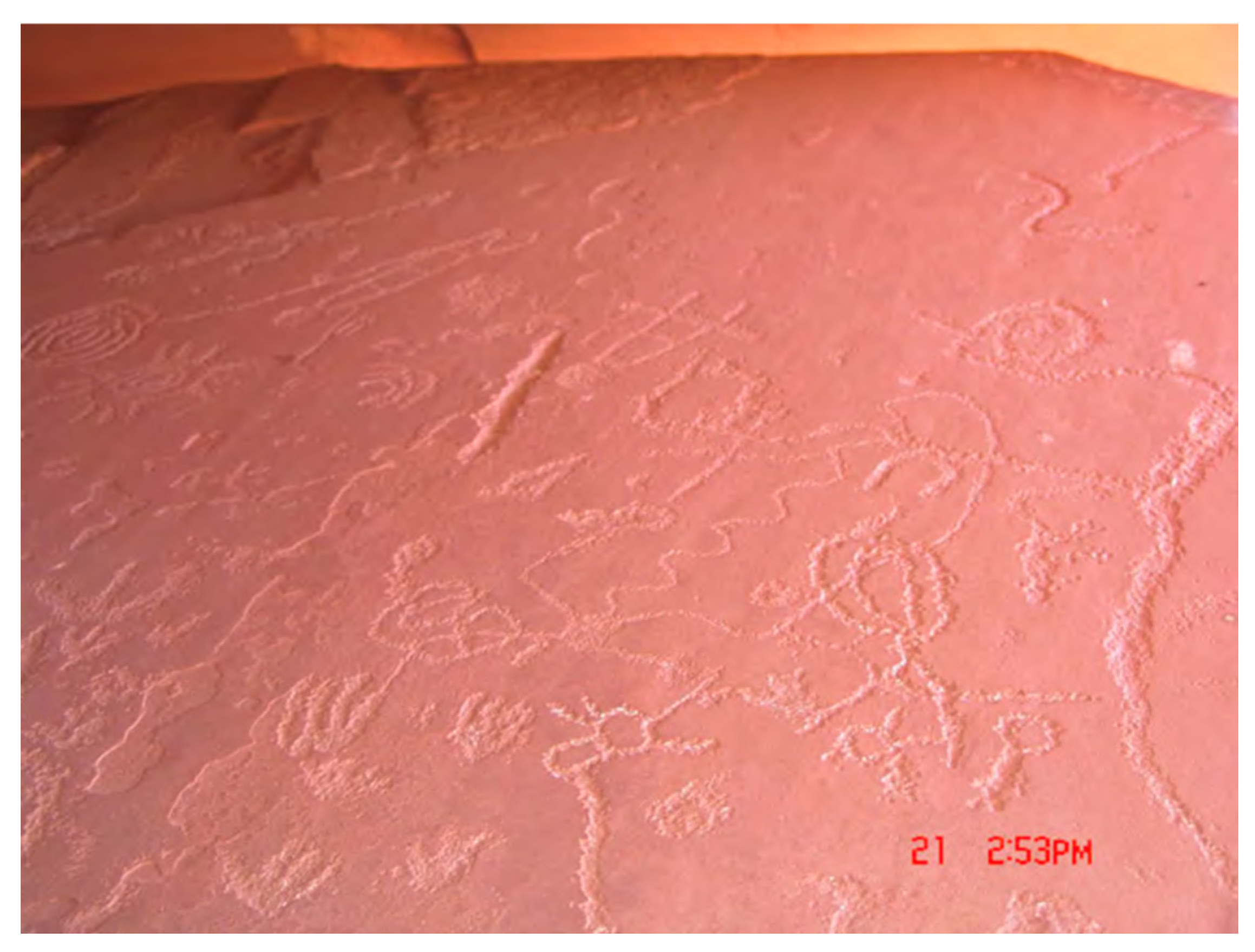
Figure 6.
Bottom of Suspended and Perched Smoothed Slab With Peckings.
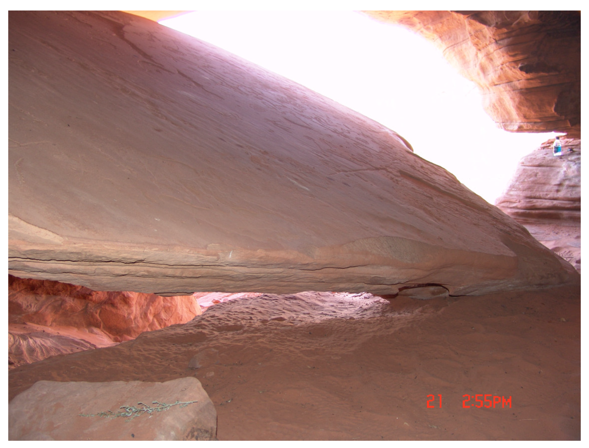
Figure 7.
Shivwits Representative Viewing Pecking and Groves on Outer Edge of Slab.
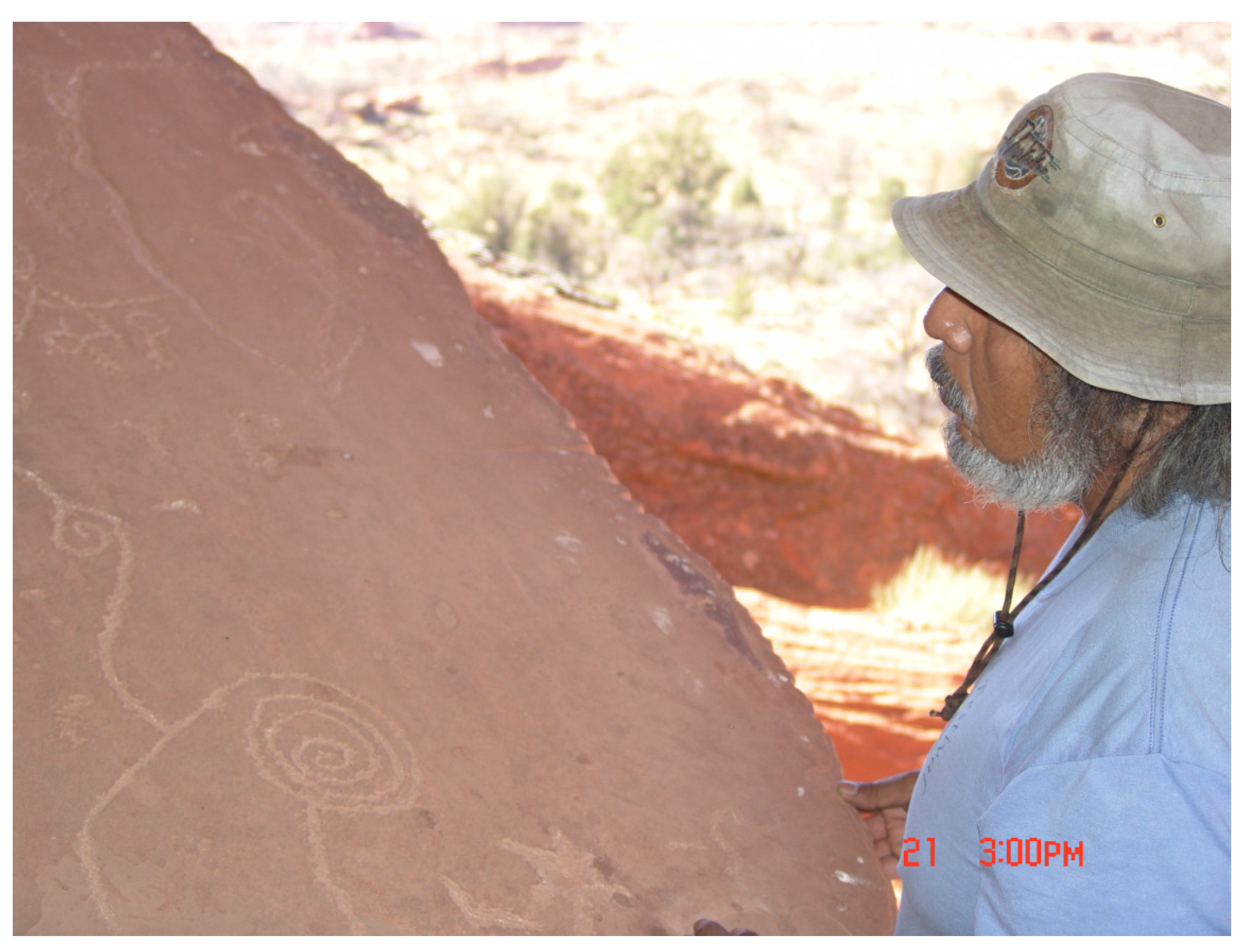
Figure 8.
Outer Edge of Slab at Entrance to the Cave With Time Marking Groves.
Figure 9.
Geology and Profile of Timber Mountain Caldera, Centered and Outlined (Christiansen and Lipman 1977).
Figure 9.
Geology and Profile of Timber Mountain Caldera, Centered and Outlined (Christiansen and Lipman 1977).
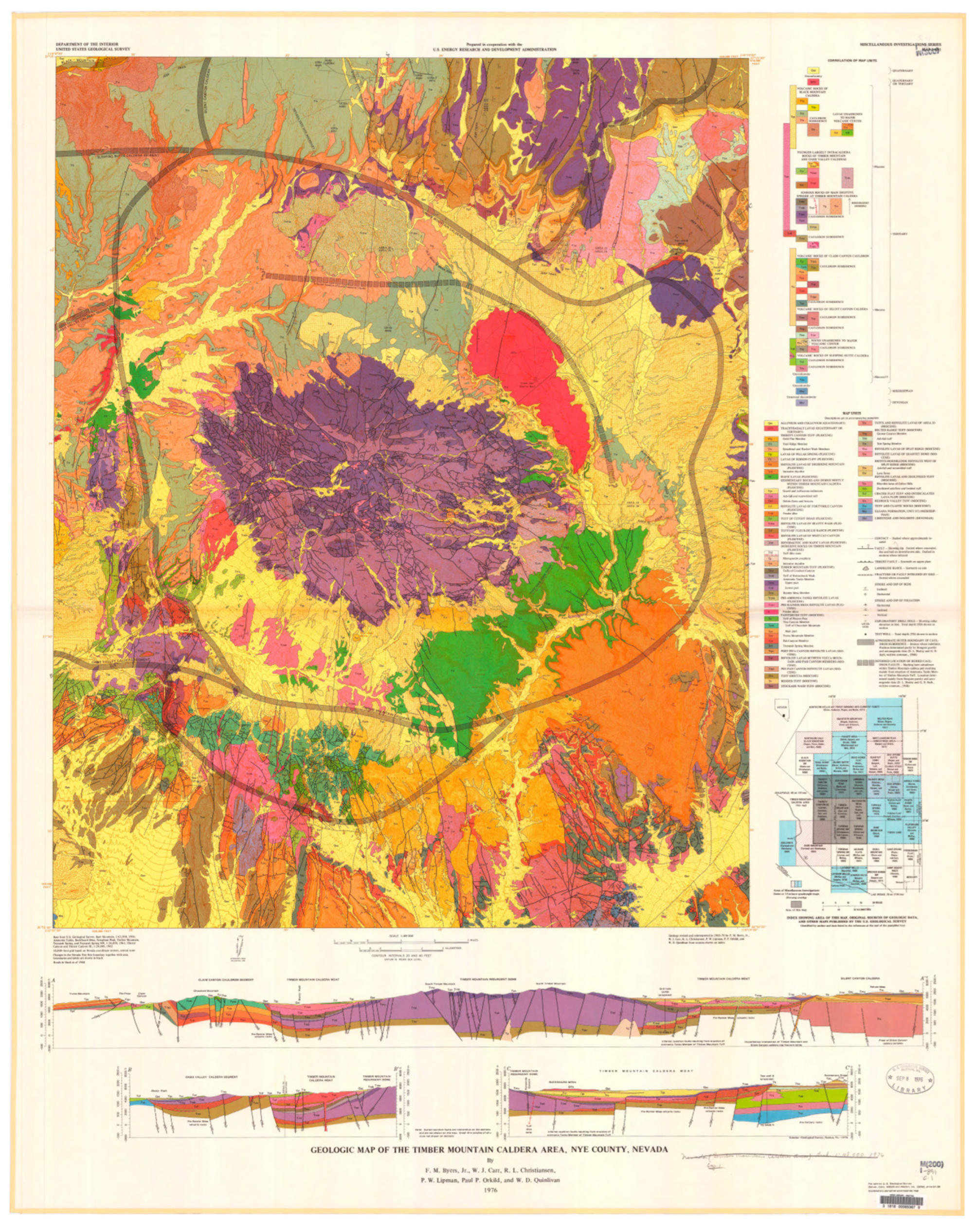
Figure 10.
Region of Timber Mountain Caldera, Colors indicate elevation and moisture.
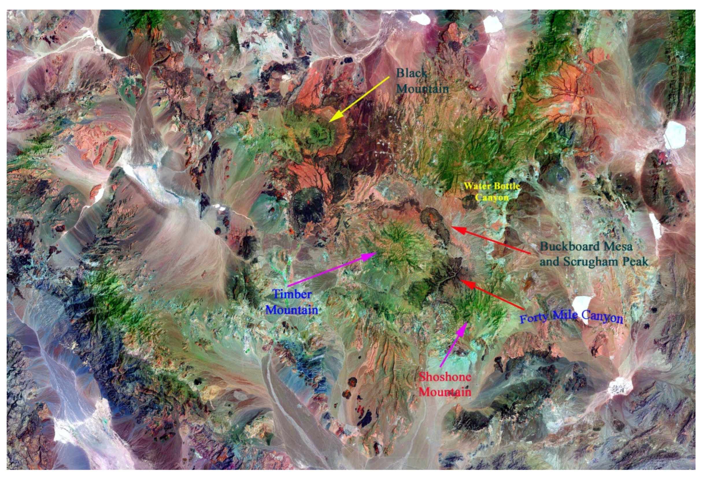
Figure 11.
Outline Map of Study Region.
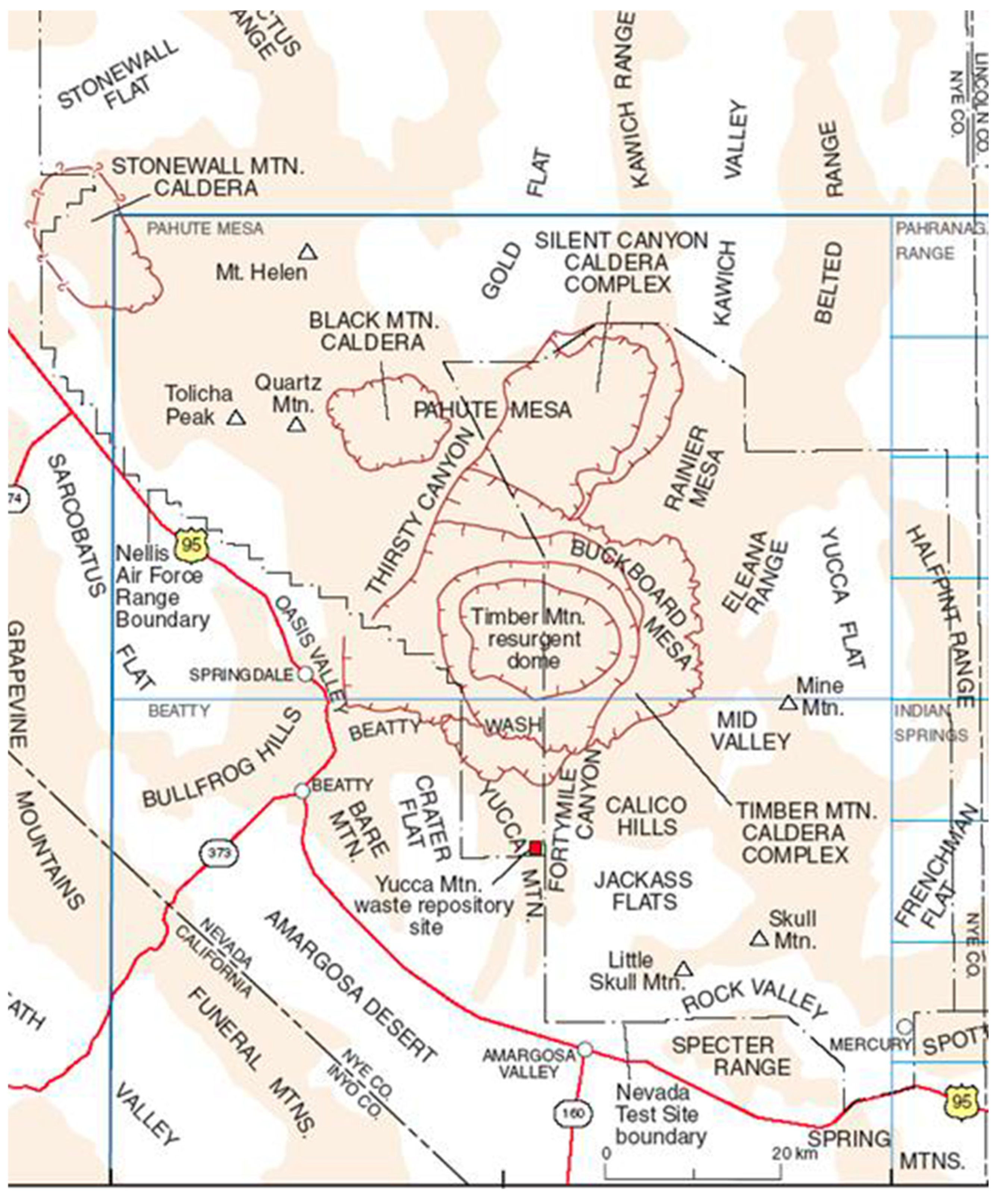
Figure 12.
Buckboard Mesa and Scrugham Peak in center, Photo Taken from Shoshone Mountain.
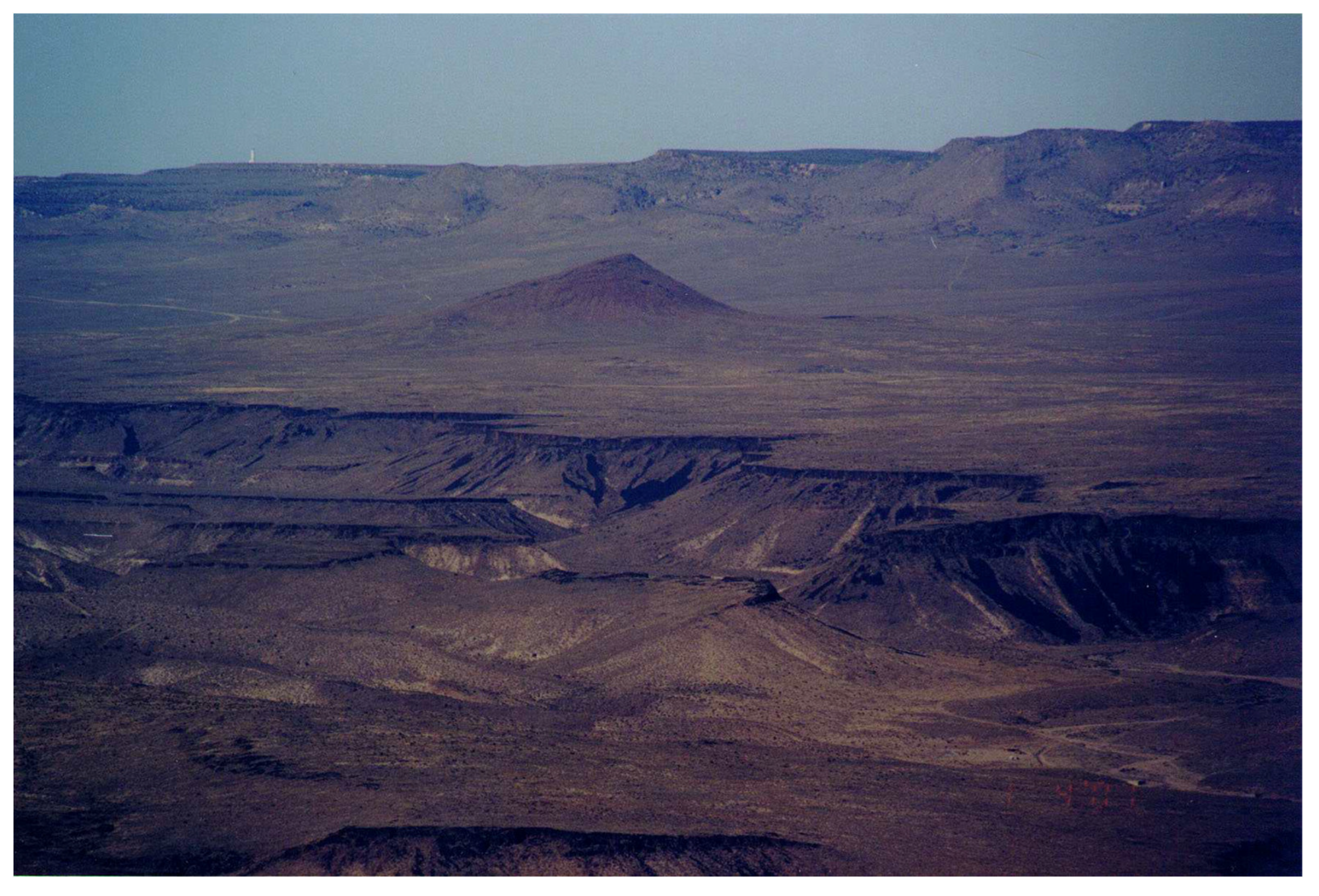
Figure 13.
Ethnographically Documented Native Trails and Key Storied Rock Places.
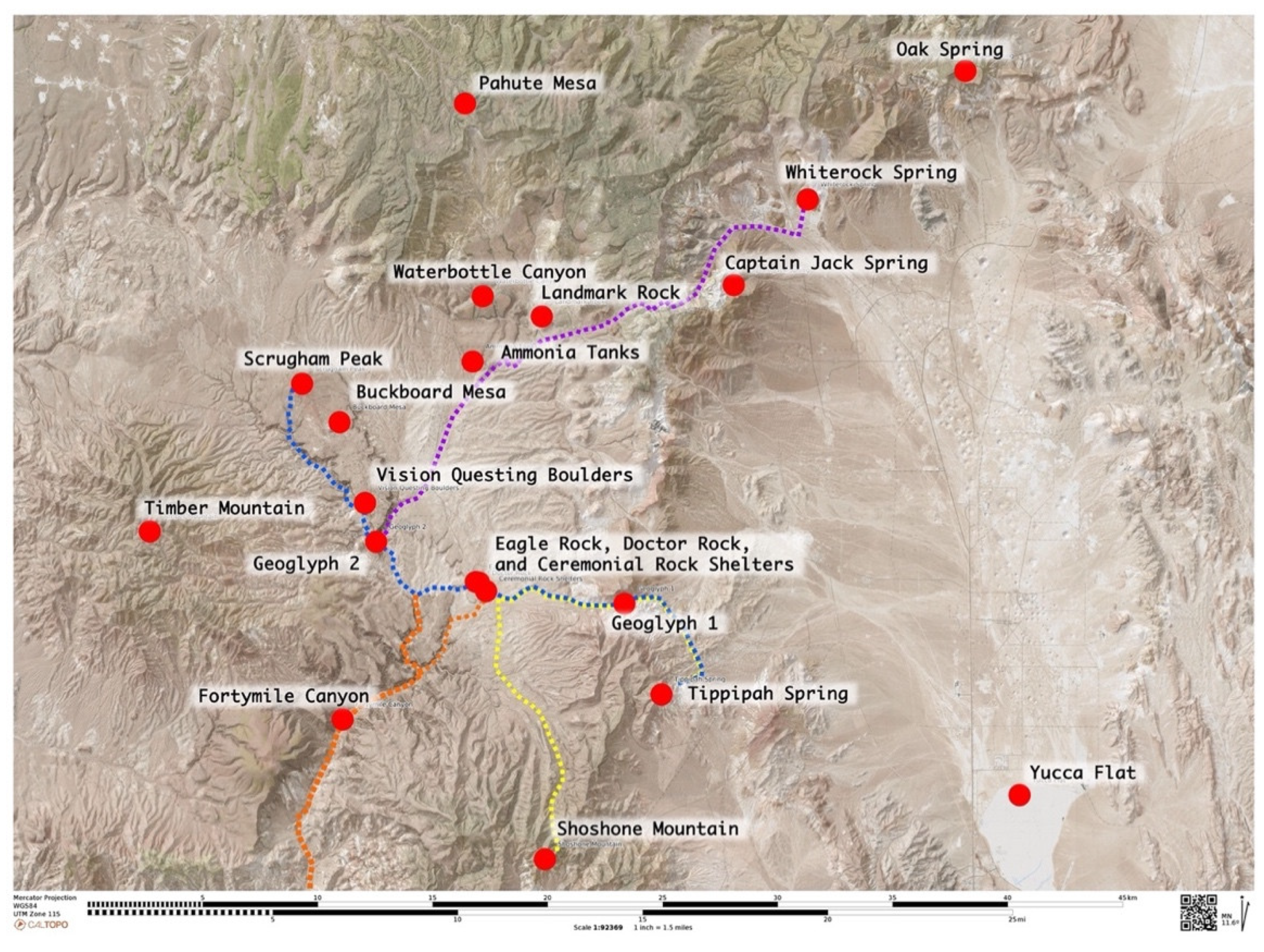
Figure 14.
Map of Story Rock Locations Near Buckboard Mesa in Timber Mountain Caldera.
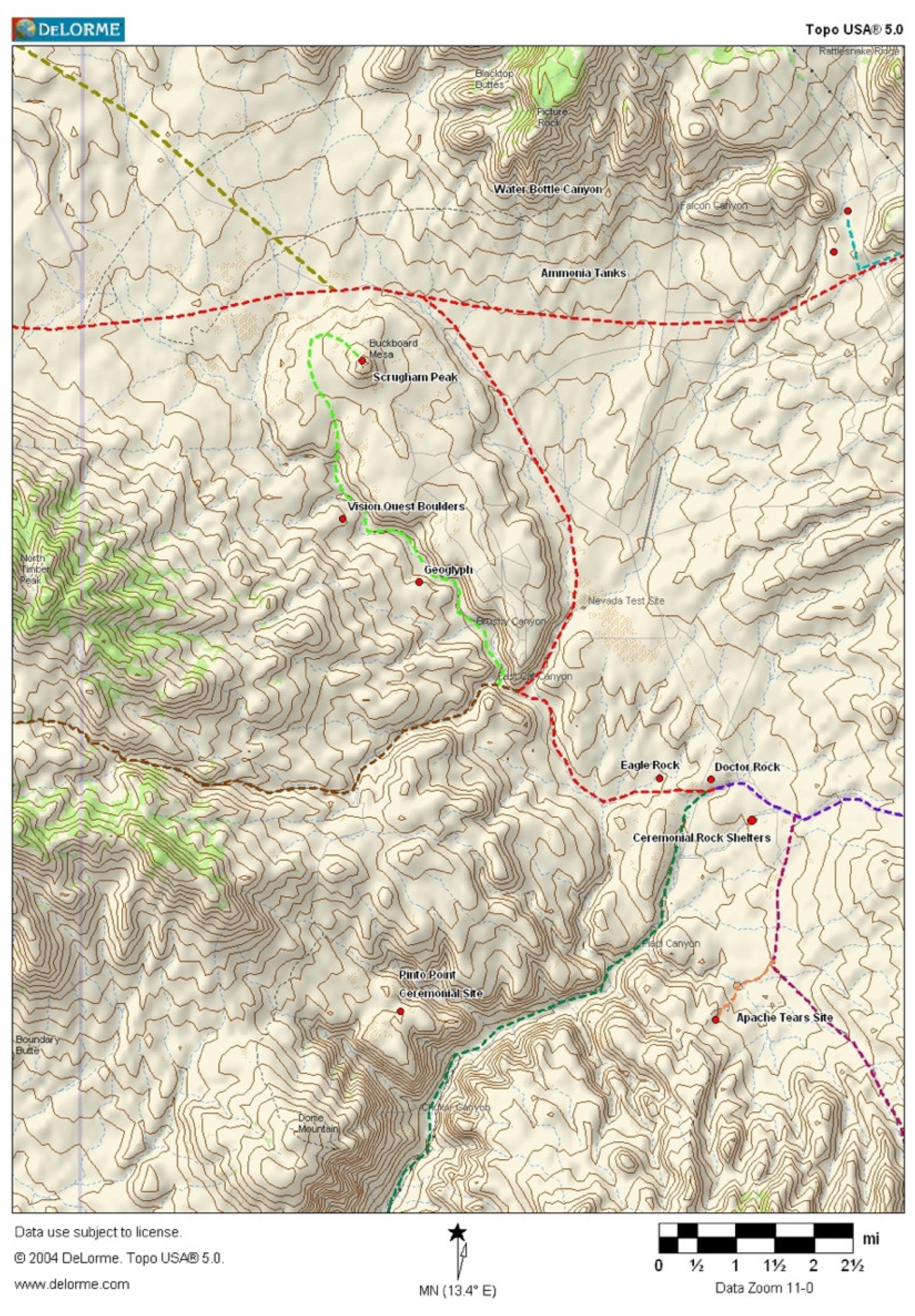
Figure 15.
Tippapah Spring at Base of Shoshone Mountain.
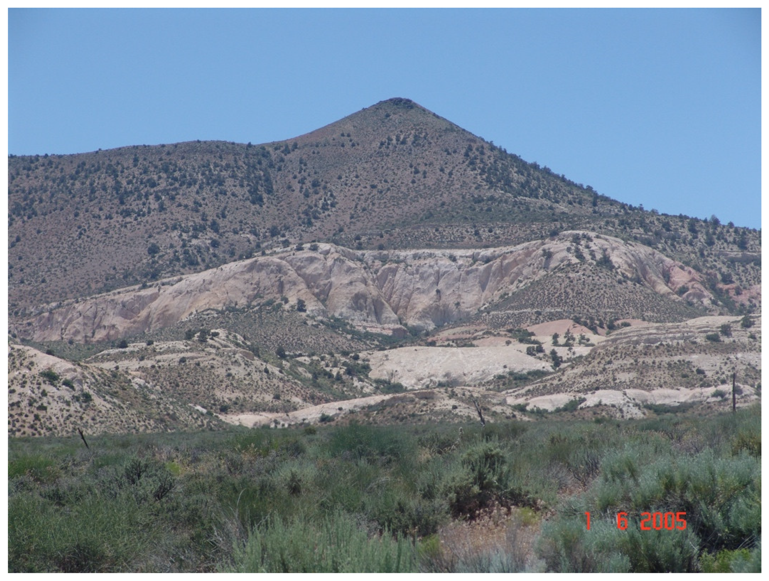
Figure 16.
The First Geoglyphs.
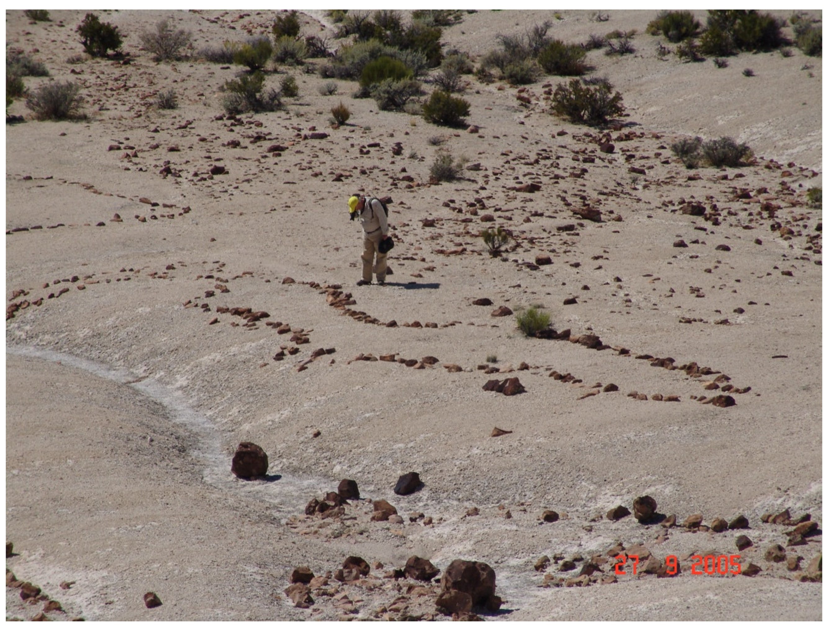
Figure 17.
The Doctor Rock Perched With a Hole in Top Surface.
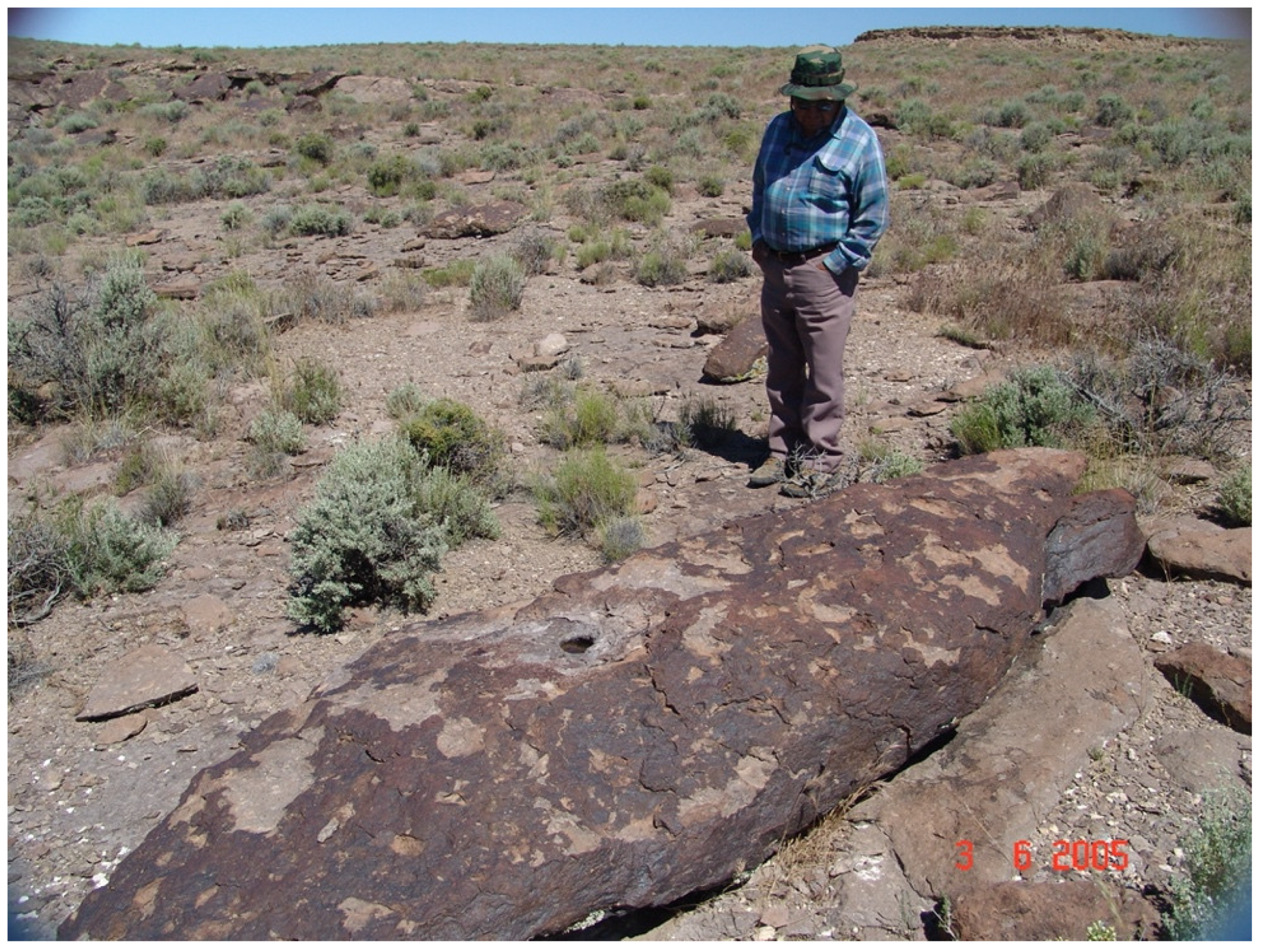
Figure 18.
The Doctor Rock Being Interpreted.
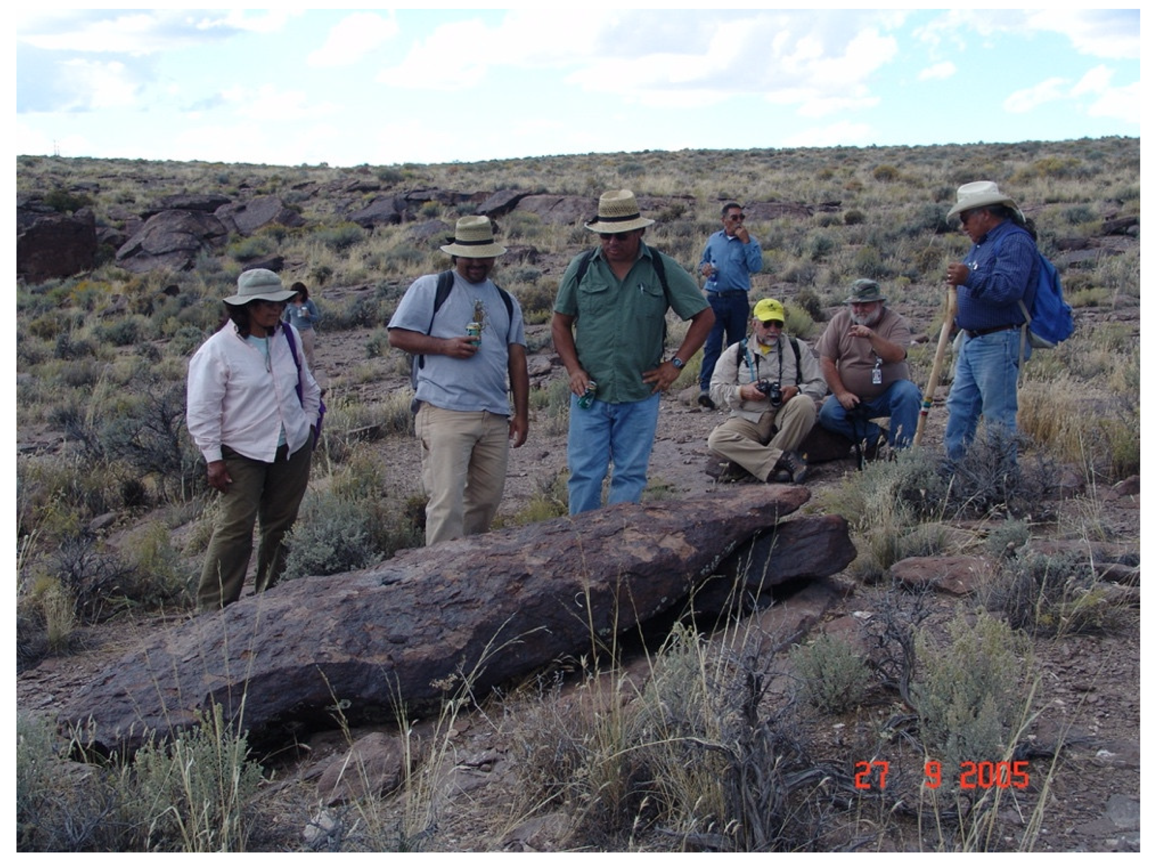
Figure 19.
The Doctor Rock Perched on Two Large Stones.

Figure 20.
Eagle Rock with Tribal Representative.
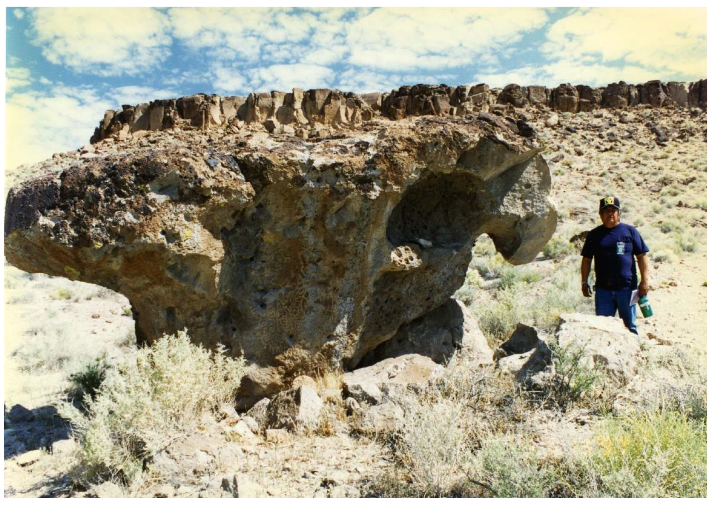
Figure 21.
Upper Forty Mile Canyon.
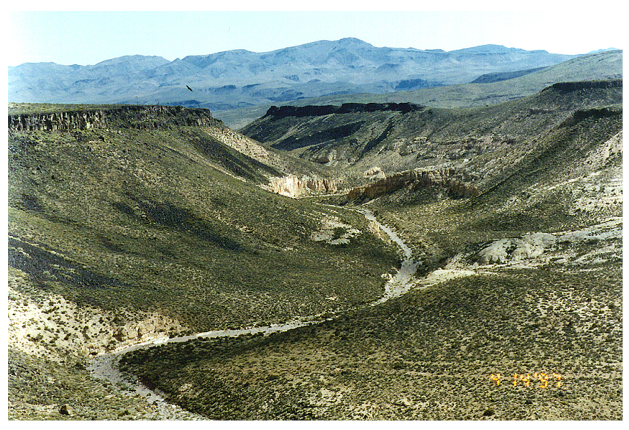
Figure 22.
Two Views Second Geoglyphs approaching Buckboard Mesa.
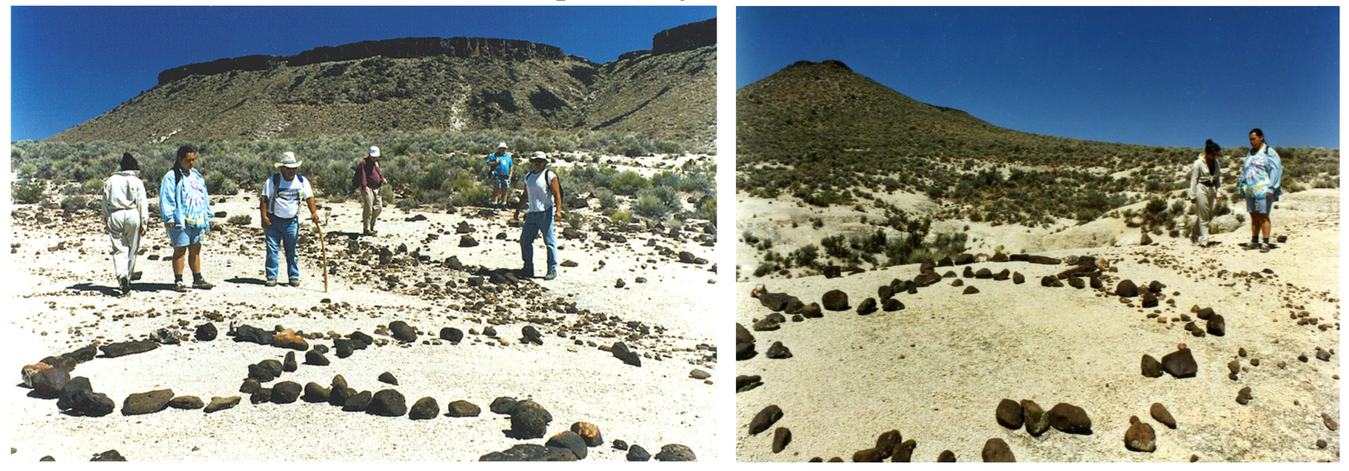
Figure 23.
Tribal Representative Pointing Out Vision Quest Boulders.
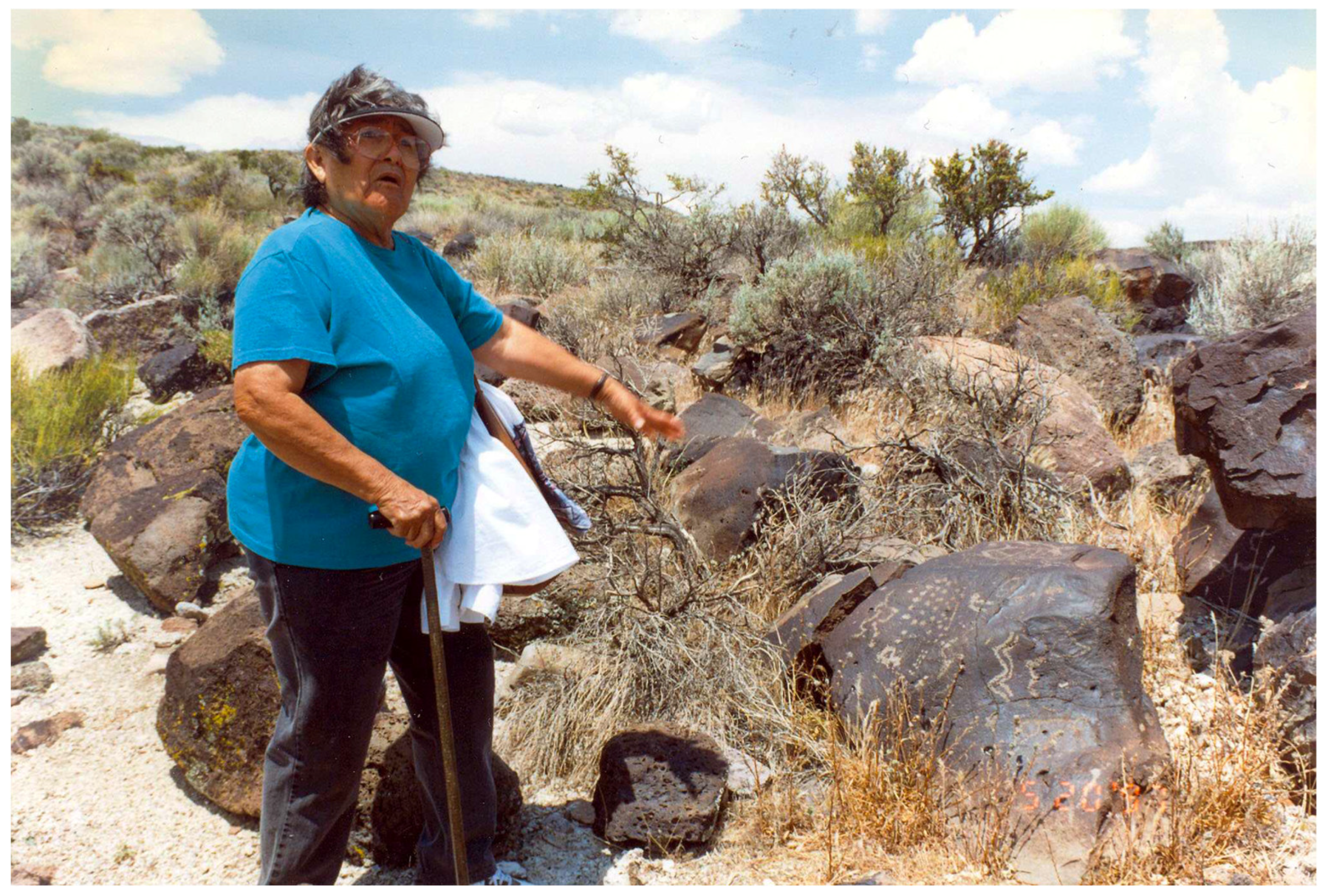
Figure 26.
Geology of Buckboard Mesa (Source Lutton 1968).
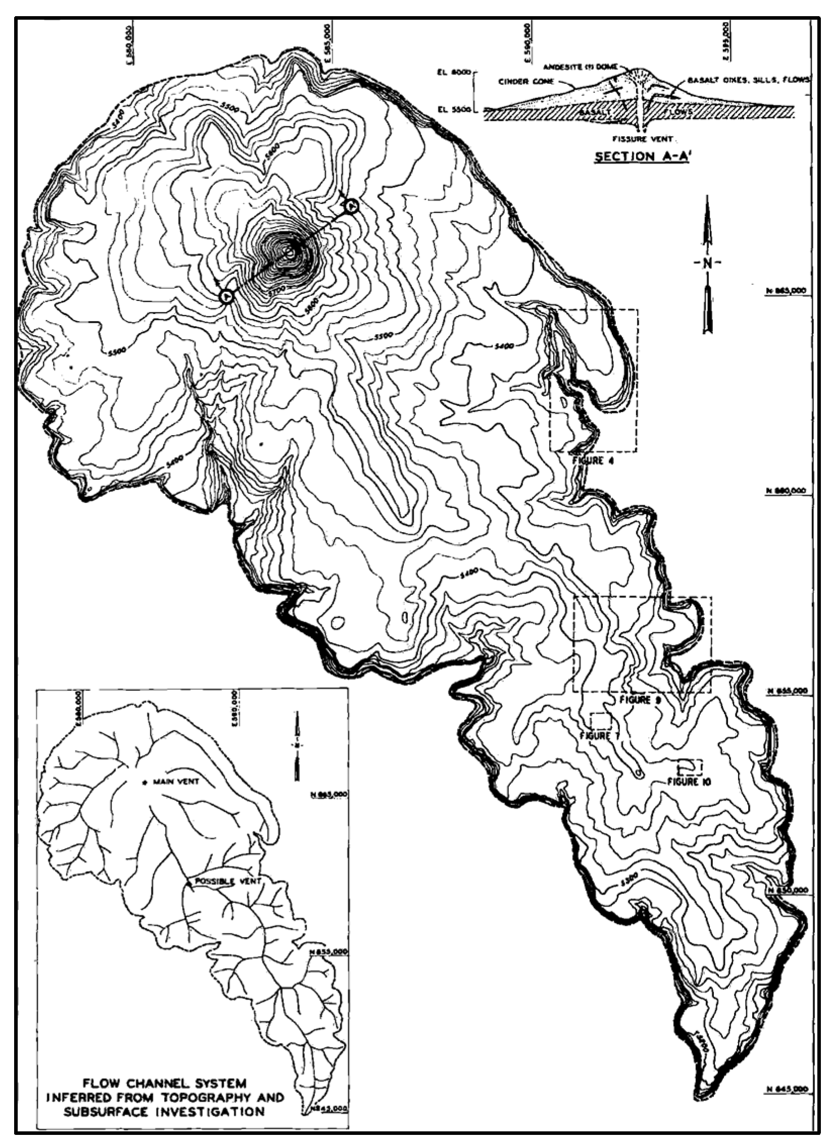
Figure 27.
Roads to and On Top of Buckboard Mesa Associated with Two Underground Atomic Bomb Tests.

Figure 28.
Vision Quest Cairns and Simi Circular Walls on Rim of Buckboard Mesa.
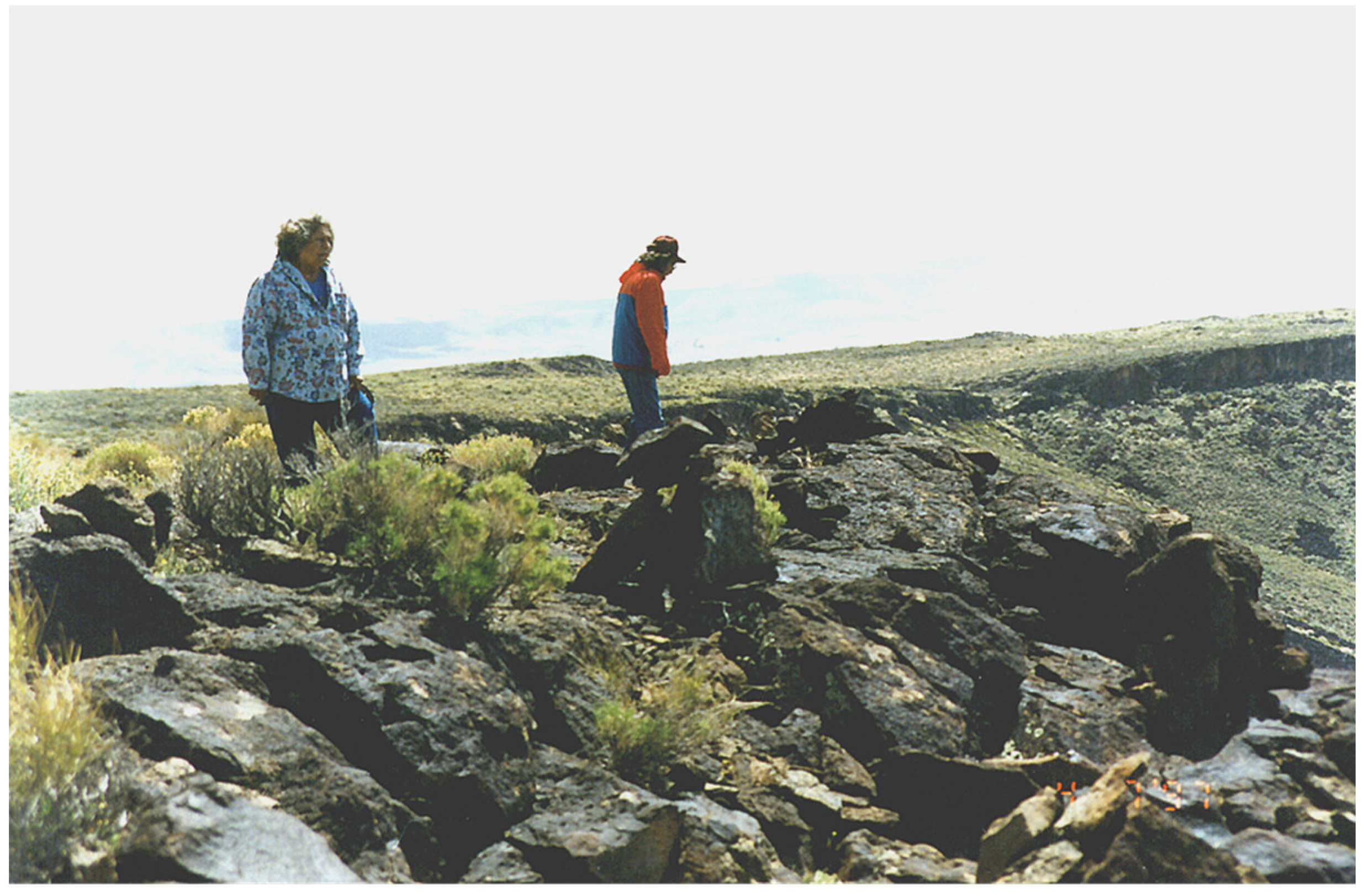
Figure 29.
Vision Quest Cairn Edge of Buckboard Mesa.
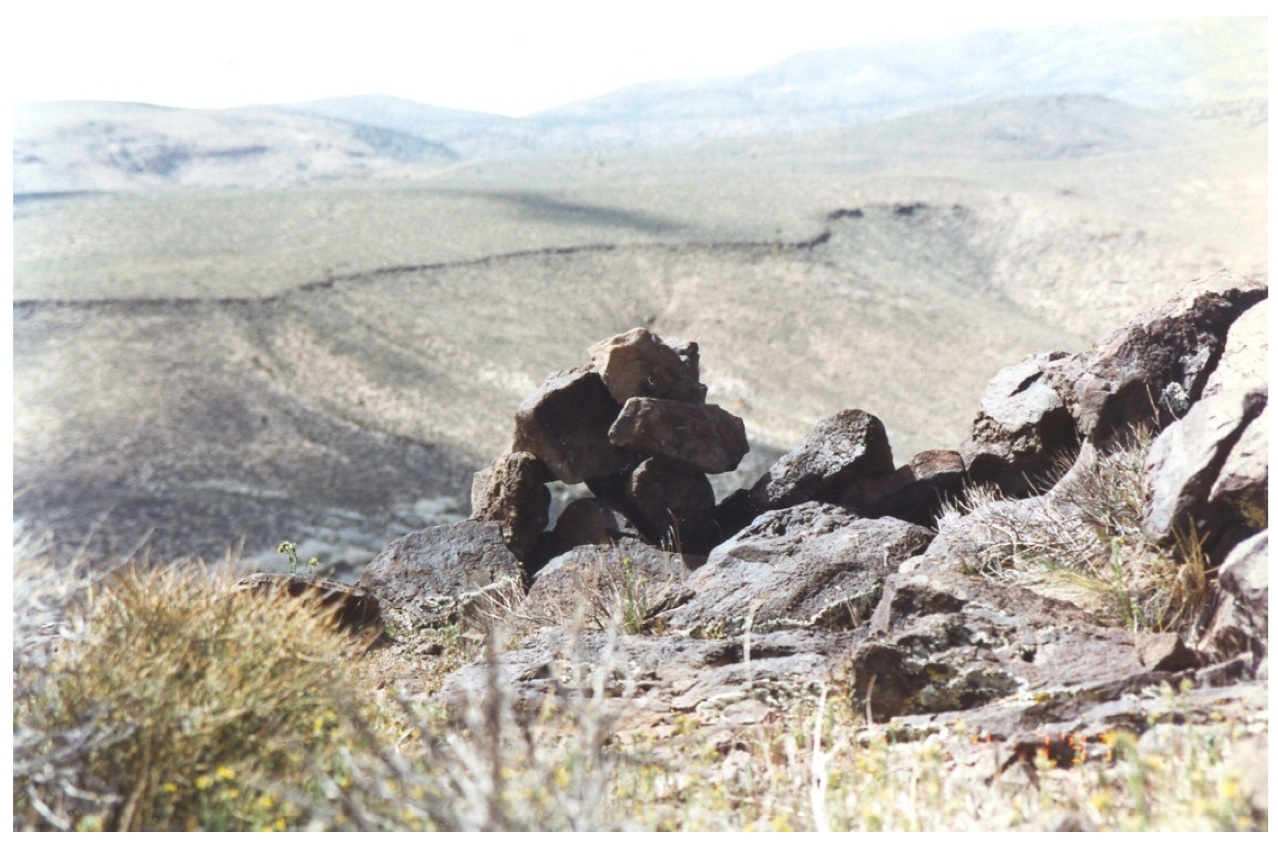
Figure 30.
Peckings Near the Edge of Buckboard Mesa.
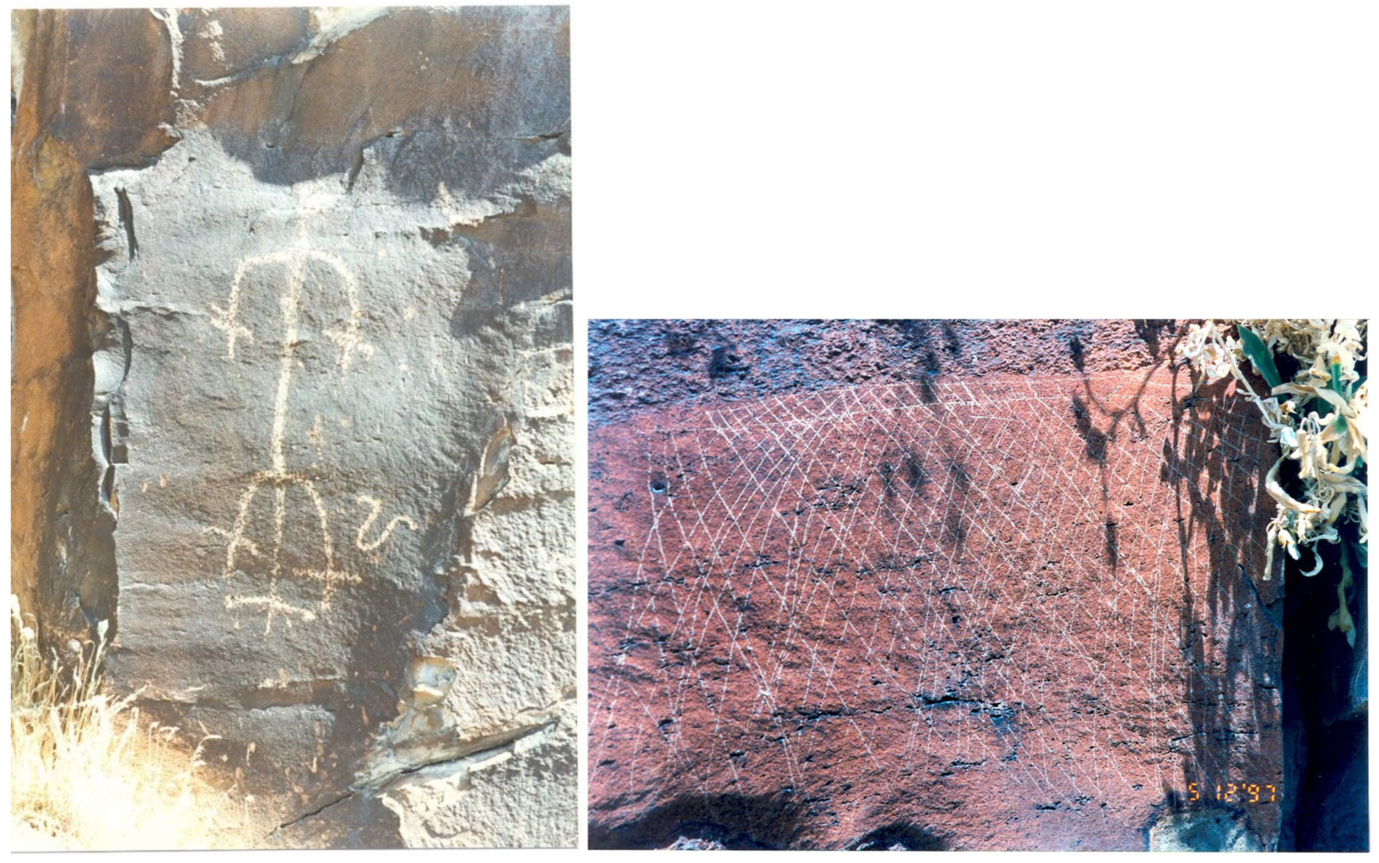
Figure 31.
Obsidian Teaching Shelter under Rim of Buckboard Mesa.
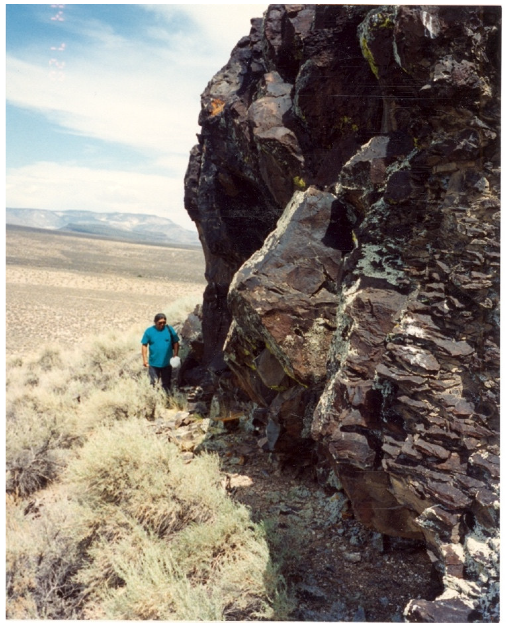
Figure 32.
Basalt Rocks Under the Edge of Buckboard Mesa.
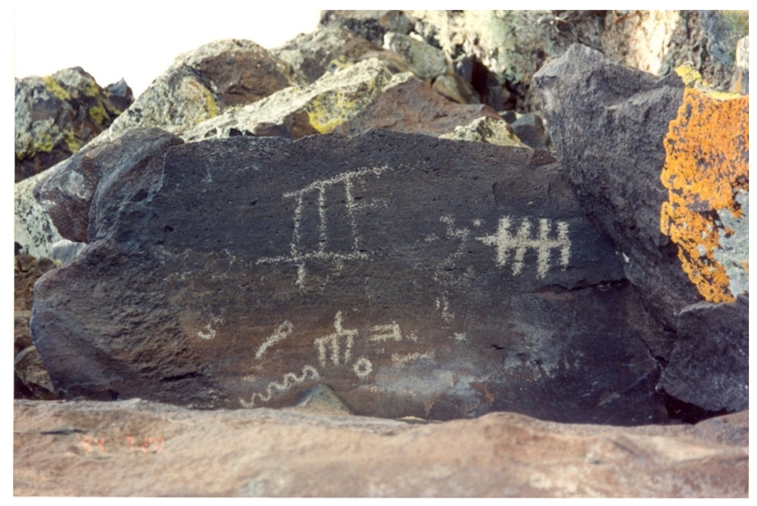
Figure 33.
Scrugham Peak on top of Buckboard Mesa.
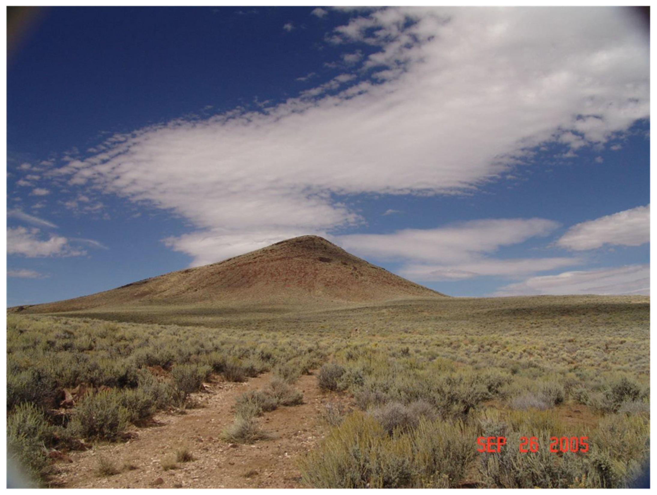
Figure 34.
Vision Questing Wall near top of Scrugham Peak.
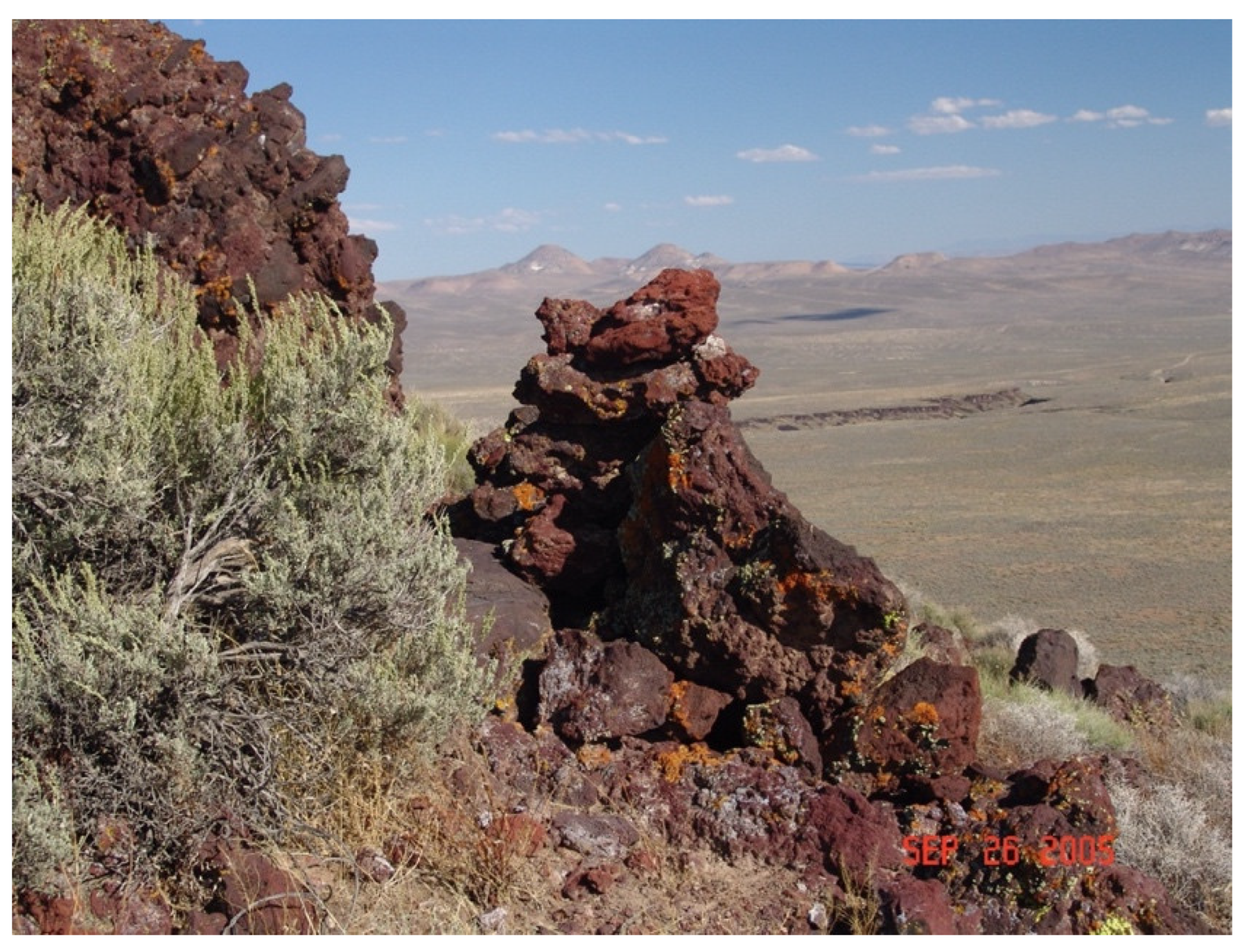
Figure 35.
Scrugham Peak Circular Rock Walls and Viewscape.
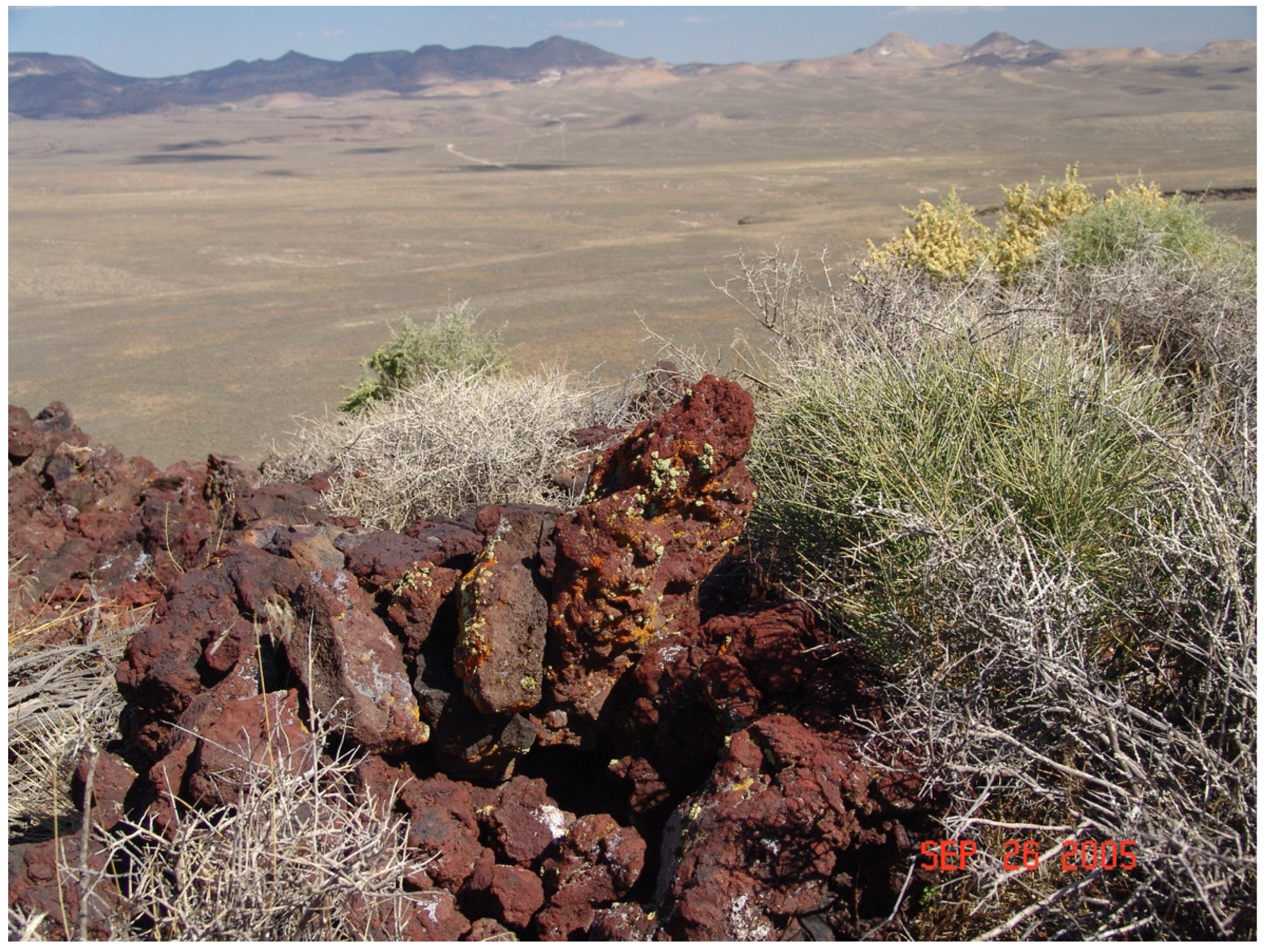

Table 1.
Interview Responses by Gender.
| Locations | Gender | |||
|---|---|---|---|---|
| Categories of Purpose | Male | Female | Total | |
| Ammonia Tanks | Communicate with spiritual beings | 7 | 1 | 8 |
| Teach other (ethnic group) people | 4 | 1 | 5 | |
| Pay respects | 5 | 5 | ||
| Communicate with other Indian people | 4 | 4 | ||
| Ceremony | 3 | 3 | ||
| To seek knowledge/power | 1 | 1 | ||
| Territorial marker | ||||
| Decoration | ||||
| Map | ||||
| NA | ||||
| Big George Cave | Teach other (ethnic group) people | 9 | 7 | 16 |
| To seek knowledge/power | 6 | 9 | 15 | |
| Pay respects | 7 | 3 | 10 | |
| Ceremony | 4 | 3 | 7 | |
| Communicate with other Indian people | 3 | 2 | 5 | |
| Communicate with spiritual beings | 3 | 2 | 5 | |
| Map | 3 | 3 | ||
| Territorial marker | 2 | 2 | ||
| NA | 1 | 1 | ||
| Decoration | ||||
| Buckboard Mesa | Ceremony | 3 | 10 | 13 |
| Communicate with other Indian people | 2 | 8 | 10 | |
| Teach other (ethnic group) people | 8 | 2 | 10 | |
| Map | 3 | 7 | 10 | |
| Pay respects | 6 | 4 | 10 | |
| To seek knowledge/power | 2 | 6 | 8 | |
| Territorial marker | 2 | 2 | ||
| Communicate with spiritual beings | ||||
| Decoration | ||||
| NA | ||||
| Busted Butte | Pay respects | 8 | 5 | 13 |
| Teach other (ethnic group) people | 3 | 3 | 6 | |
| To seek knowledge/power | 3 | 1 | 4 | |
| Ceremony | 2 | 2 | ||
| Territorial marker | 2 | 2 | ||
| Map | 1 | 1 | ||
| NA | 1 | 1 | ||
| Communicate with other Indian people | ||||
| Communicate with spiritual beings | ||||
| Decoration | ||||
| Captain Jack Cave | Pay respects | 8 | 2 | 10 |
| Communicate with spiritual beings | 7 | 7 | ||
| Teach other (ethnic group) people | 5 | 1 | 6 | |
| NA | 4 | 4 | ||
| Ceremony | 2 | 1 | 3 | |
| Communicate with other Indian people | 2 | 1 | 3 | |
| To seek knowledge/power | 2 | 2 | ||
| Territorial marker | ||||
| Decoration | ||||
| Map | ||||
| Cot Cave | Pay respects | 4 | 2 | 6 |
| Ceremony | 3 | 2 | 5 | |
| Teach other (ethnic group) people | 3 | 2 | 5 | |
| To seek knowledge/power | 3 | 1 | 4 | |
| Communicate with spiritual beings | 1 | 1 | ||
| Communicate with other Indian people | ||||
| Territorial marker | ||||
| Decoration | ||||
| Map | ||||
| NA | ||||
| Mushroom Rock | Ceremony | 4 | 10 | 14 |
| Pay respects | 4 | 3 | 7 | |
| Communicate with spiritual beings | 6 | 6 | ||
| Territorial marker | 2 | 2 | ||
| NA | 2 | 2 | ||
| To seek knowledge/power | 1 | 1 | ||
| Teach other (ethnic group) people | 1 | 1 | ||
| Communicate with other Indian people | ||||
| Decoration | ||||
| Map | ||||
| Power Rock Site | Ceremony | 2 | 2 | 4 |
| To seek knowledge/power | 2 | 2 | 4 | |
| Pay respects | 2 | 2 | 4 | |
| Communicate with spiritual beings | 1 | 1 | 2 | |
| Territorial marker | 2 | 2 | ||
| Communicate with other Indian people | ||||
| Teach other (ethnic group) people | ||||
| Decoration | ||||
| Map | ||||
| NA | ||||
| Rice Village Site | Teach other (ethnic group) people | 4 | 7 | 11 |
| Ceremony | 4 | 6 | 10 | |
| Communicate with spiritual beings | 6 | 4 | 10 | |
| Pay respects | 5 | 2 | 7 | |
| To seek knowledge/power | 3 | 3 | ||
| Map | 1 | 2 | 3 | |
| Communicate with other Indian people | 1 | 1 | ||
| Territorial marker | ||||
| Decoration | ||||
| NA | ||||
| Twin Springs | Pay respects | 3 | 4 | 7 |
| Communicate with other Indian people | 3 | 3 | ||
| Teach other (ethnic group) people | 3 | 3 | ||
| Map | 2 | 1 | 3 | |
| Ceremony | 2 | 2 | ||
| To seek knowledge/power | 2 | 2 | ||
| Territorial marker | 2 | 2 | ||
| NA | 1 | 1 | ||
| Communicate with spiritual beings | ||||
| Decoration | ||||
Disclaimer/Publisher’s Note: The statements, opinions and data contained in all publications are solely those of the individual author(s) and contributor(s) and not of MDPI and/or the editor(s). MDPI and/or the editor(s) disclaim responsibility for any injury to people or property resulting from any ideas, methods, instructions or products referred to in the content. |
© 2024 by the authors. Licensee MDPI, Basel, Switzerland. This article is an open access article distributed under the terms and conditions of the Creative Commons Attribution (CC BY) license (http://creativecommons.org/licenses/by/4.0/).
Copyright: This open access article is published under a Creative Commons CC BY 4.0 license, which permit the free download, distribution, and reuse, provided that the author and preprint are cited in any reuse.


