
Submitted:
17 August 2024
Posted:
19 August 2024
You are already at the latest version
Abstract
Sustainable water resource management in Bangladesh's Gumti River Basin faces challenges from climate change, urbanization, and population growth. This study aimed to calibrate and validate the HEC-HMS model for the Gumti River to enhance flood prediction and water resource planning. The model was set up using precipitation, temperature, and discharge data from 2019-2021, with SRTM elevation data for catchment delineation. Manual calibration was performed for 2019-2020, followed by validation for 2021, using parameters such as Muskingum routing and SCS Curve Number. Model performance was evaluated using R², Nash-Sutcliffe efficiency (NSE), RSR, and PBIAS metrics. Results showed satisfactory to good performance, with R² values of 0.64 and 0.68 for calibration and validation, respectively. NSE values were within the satisfactory range, while PBIAS indicated very good performance with slight underestimation. The study concludes that the calibrated HEC-HMS model provides a reliable tool for simulating the Gumti River's hydrology, though there's room for improvement. Integration with flood frequency analysis, water quality monitoring, and climate change projections is recommended for comprehensive water resource management, alongside the implementation of Sustainable Water Resource Management principles and community engagement strategies.
Keywords:
Gumti River
; HEC-HMS
; Hydrological Modeling
; Calibration
; Parameters
; Management Practices
1. Introduction
Hydrology, as a branch of science, intricately examines the occurrence, distribution, and circulation of water resources on a global scale, encompassing their physical and chemical characteristics and the interaction with surrounding environments [1]. Through the application of engineering and geographical principles, hydrology provides critical guidance for water resource planning, management, and control [2]. In the context of climate change, accurately estimating water availability in river basins is essential, a task that can be effectively achieved through hydrological modeling [3]. Hydrological models, which can be established using small-scale physical models, mathematical analogues, and computer simulations, offer a simplified yet powerful representation of complex hydrologic systems, making them indispensable for predicting water resource behavior [3,4].
The HEC-HMS (Hydrologic Engineering Center – Hydrologic Modeling System) developed by the United States Army Corps of Engineers is one of the most widely used tools for hydrological modeling [5]. Designed to simulate the precipitation-runoff processes in watershed systems, HEC-HMS has been applied in various geographical settings to address issues ranging from flood hydrology to urban runoff [6]. The model's versatility, open-access nature, and extensive capabilities have made it a preferred choice among researchers, particularly for applications in large river basins and complex hydrologic scenarios [7]. Calibration and validation of such models are critical to ensure their predictive accuracy and reliability, thereby enhancing user confidence in their application [2].
In Bangladesh, physically-based hydrological models like HEC-HMS, SWAT, TOPMODEL, VIC and MIKE-SHE have been extensively utilized [8,9,10,11,12]. Among these, HEC-HMS stands out for its simplicity, user-friendly interface, and robust performance in diverse hydrologic conditions [13]. The model's ability to accurately simulate the hydrologic cycle by dividing it into manageable components makes it highly effective for watershed modeling [14]. Calibration and validation processes, involving the adjustment of model parameters to fit historical data, are essential steps in ensuring that the model can reliably predict future hydrologic events [15]. The performance of these models is typically evaluated using statistical measures such as R², Nash-Sutcliffe efficiency (NSE), RMSE, and MAE [2].
For the Gumti River in Bangladesh, the need for accurate hydrological modeling is particularly pressing given the region's vulnerability to climate change and the associated hydrological extremes [16]. The Gumti River basin, like many others in South Asia, faces challenges such as variable precipitation patterns, extreme weather events, and significant socio-economic impacts [17]. Effective water resource management in this basin necessitates a reliable hydrological model that can simulate current conditions and predict future scenarios. This study aims to calibrate and validate the HEC-HMS model for the Gumti River, thereby providing a robust tool for flood risk assessment and water resource planning in the region.
The calibration and validation of the HEC-HMS model for the Gumti River will involve an in-depth analysis of the river basin's hydrologic response to precipitation. This process includes the collection and analysis of historical hydrological data, the adjustment of model parameters, and the evaluation of model performance through statistical measures. The ultimate goal is to develop a calibrated and validated hydrological model that can accurately simulate the flow hydrograph from tributary catchments, serving as a critical input for further hydraulic modeling and flood risk assessment.
In summary, this study addresses the critical need for accurate hydrological modeling in the Gumti River basin, aiming to enhance water resource management and flood risk assessment through the calibration and validation of the HEC-HMS model. By providing a reliable tool for predicting hydrological responses to climatic and anthropogenic changes, this research contributes to the broader effort of sustainable water resource management in Bangladesh.
2. Materials and Methods
2.1. Study Area
The Gumti River originates in the northeastern hills of Tripura, India, and enters Bangladesh near Katak Bazar in Comilla Sadar [18]. Flowing through the Comilla district in southeastern Bangladesh, it ultimately joins the Meghna River at coordinates 23°31'46.0"N 90°42'08.0"E [19]. The section from its entry point into Bangladesh to its confluence with the Meghna forms the core of this research area. The river and its tributaries are shown in Figure 1. Within Bangladesh, the Gumti River (also known as Gumti) stretches for approximately 135 kilometers [20]. This significant portion of its total length makes it a crucial water resource for the region. The focus of this study is this 135-kilometer stretch within Bangladesh, offering a rich opportunity to explore the river's hydrological characteristics and importance to local communities.
2.2. Data Collection
Daily precipitation and temperature data were collected from one station, Comilla for the past three years (2019-2021) (Figure 2). Hourly evaporation data for the same years for Gumti river was used in the study (Figure 2). The precipitation and the temperature data were obtained from the Climate division of the Bangladesh Meteorological Department. The evaporation reanalysis data were obtained from the European Centre for Medium-Range Weather Forecasts (ECMWF) [21]. Daily river discharge data for the same years at Comilla (SW110) station was obtained from the Bangladesh Water Development Board (BWDB). Monthly minimum flows were considered as the base flow accordingly at the Comilla gauging station. The SRTM 1 Arc-Second Global elevation data, with a resolution of 30 meters [22], was used for the whole catchment area which provides worldwide coverage in Georeferenced Tagged Image File Format (GeoTIFF), using WGS84 for the horizontal datum and EGM96 for the vertical datum. Table 1 shows the summary of the selected tide stations along with their sources and data availability.
2.3. Data Map Preparation
ArcGIS 10.7 was used to delineate the catchment area. The watershed and sub basins delineation were carried out based on an automatic delineation procedure using the SRTM 1 arc-Second Global elevation data and digitized stream networks (Figure 3).
2.4. HEC-HMS Model Set-Up
The HEC-HMS 4.11 software was employed for the hydrological analysis model setup, comprising four main components: basin model, meteorological model, control specifications, and input data. The basin model represents the drainage system's water movement through hydrologic elements and their connectivity, while the meteorological component distributes precipitation input spatially and temporally over the river basin. For this study, only the Comilla station was utilized, as shown in Table 1, which presents the adopted precipitation, temperature, and discharge stations. Table 2 outlines the model elements and parameters applied in the HEC-HMS setup. The sub-basin methods included Simple Canopy for canopy, Simple Surface for surface, SCS Curve Number for loss, SCS Unit Hydrograph for transform, and Recession for baseflow (Table 2). Additionally, the Muskingum method was applied for reach routing. This comprehensive setup allows for a detailed analysis of the Gumti River's hydrological characteristics within the study area.
2.5. Model Calibration and Validation
To ensure the reliability of the hydrological model's outputs, calibration and validation using observed stream flow data were conducted. All parameters were adjusted from their initial values until a good fit between simulated and observed stream flows was achieved (Table 3, Table 4 and Table 5). The model underwent calibration from January 1, 2019, to December 31, 2020, by adjusting identified parameters to achieve a good fit between simulated and observed data. The validation phase, spanning from January 1, 2021, to December 31, 2021, served as a critical test of the model's performance. This process of comparing simulated stream flow to observed data allows for the evaluation of the model's goodness of fit and its ability to predict and present credible results. As emphasized by Vaze et al. [27], validation is a key criterion in assessing a hydrological model's performance, ensuring its applicability and reliability for the Gumti River study area.
The HEC-HMS hydrological model was manually calibrated to optimize and obtain the best possible fit. Parameters optimized for good calibration included Muskingum-K, Muskingum-x, SCS Curve Number - Initial Abstraction, and SCS Curve Number – Curve Number. The calibration and validation performance of HEC-HMS 4.11 was assessed by comparing daily simulated runoff with observed stream flow at the catchment outlet (Sink in the Figure 1). To evaluate the model's predictability in representing the basin's hydrological reality, four basic statistical performance metrics were employed: coefficient of determination (R2), Nash-Sutcliffe efficiency [28], root mean square error-standard deviation ratio (RSR), and percent bias (PBIAS). These metrics provide a comprehensive assessment of the model's ability to simulate the Gumti River's hydrological characteristics accurately.
2.5.1. Soil Conservation Service (SCS) Curve Number Method
In the calibration and validation process, the Soil Conservation Service (SCS) Curve Number (CN) loss method was optimized. This method implements the curve number methodology to calculate incremental losses [29]. The Initial Abstraction parameter defines the precipitation threshold that must be exceeded before surface excess occurs. The Curve Number itself represents a composite value that encapsulates the various soil group and land use combinations within the sub-basin [30].
2.5.2. Muskingum Routing Method
In the calibration and validation process, the Muskingum Routing method was optimized to simulate flow through the stream reach. This method employs a simple conservation of mass approach, with two key parameters: Muskingum K and Muskingum X. Muskingum K represents the travel time through the reach and can be estimated from cross-sectional and flow properties, though it may also serve as a calibration parameter. Muskingum X, ranging from 0.0 to 0.5, weighs the influence of inflow versus outflow. A value of 0.0 results in maximum attenuation, while 0.5 yields no attenuation. Most stream reaches require an intermediate value, determined through calibration [31].
By fine-tuning these parameters, the model can more accurately represent the flow dynamics and attenuation characteristics of the Gumti River, enhancing the overall reliability of the hydrological simulations.
2.6. Model Performance Evaluation
Finally, the model performance was evaluated for both calibration and validation in different ways including R2, Nash-Sutcliffe efficiency [28], RSR and PBIAS.
- By visually inspecting and comparing the calculated and observed hydrograph.
- The Coefficient of determination (R2)
R2 is a standard regression criterion which is limited because it only evaluates the linear relationships between observed and simulated variables. Legates and McCabe Jr. [32] and Moriasi et al. [33] recommended that a good model efficiency criterion have at least three important components, which are improvements over the coefficient R2: one dimensionless statistic, one absolute error index statistic and one graphical technique. That means that none of the statistics should be used alone; applied together, they form a set of model selection criteria which offsets each other’s limitions [34,35]. According to the categorization of the most used statistics, we added the following criteria:
- 3.
- The dimensionless statistic: Nash-Sutcliffe model Efficiency [28] given by:
Nash-Sutcliffe efficiencies can range from -∞ to 1. An efficiency of NSE=1 corresponds to a perfect match of modelled discharge to the observed data. An efficiency of NSE=0 indicates that the model predictions are as accurate as the mean of the observed data, whereas an efficiency less than zero (-∞<NSE<0) occurs when the observed mean is a better predictor than the model. The closer the model efficiency is to 1, the more accurate the model is [28].
- 4.
- The absolute error index represented by the Root Mean Squared Error (RMSE) - standard deviation ratio (RSR) of observations given by:
RSR ranges from 0 (optimal value) to 0.5 (very good performance) ratings for both calibration and validation periods. Lower values of RSR indicate a lower root mean square error normalized by the standard deviation of the observations, which indicates the appropriateness of the model simulation [33,36]
- 5.
- The dimensionless statistic: percentage of bias (PBIAS) given by:
PBIAS = 0 occurs for a hydrological model with optimal performance. Positive or negative values indicate, respectively, that the model overestimates or underestimates the simulated flows [37].
3. Results
3.1. Calibration and Validation
The HEC-HMS model underwent manual calibration using observed stream flow data from the Comilla gauging station for the period of January 1, 2019, to December 31, 2020. Figure 4 illustrates the close agreement between simulated and observed stream flows during the calibration period, particularly in terms of peak values and flow distribution. The optimized parameter values for the study area are presented in Table 7. For validation, the model was run with these optimized parameters for the period of January 1, 2021, to December 31, 2021, to assess its predictive capability at the Comilla gaging station.
3.2. Model Performance Evaluation
Model performance evaluation was conducted for the calibration and validation periods. The time series of simulated and observed flows from the results of the simulation run in the HEC-HMS model were analyzed in Microsoft Excel to compute the statistics used for performance evaluation. The statistics that were used are described in Section 2.6, presented earlier. The performance ratings of these parameters are presented in Table 8. During calibration for the Comilla gauging station, the values of R2, RSR, NSE and PBIAS were found to be 0.64, 0.60, 0.585 and -2.59%, respectively. Similarly, during the validation, the model evaluation criteria for R2, RSR, NSE and PBIAS were found to be 0.68, 0.70, 0.513 and -3.78% respectively. Figure 4 displays the performance evaluation of the HEC-HMS model for the calibration and validation periods. According to Table 6, the model performance ranges from satisfactory to very good.
4. Discussion
The HEC-HMS model required proper calibration of loss and routing parameters to accurately predict runoff in the Gumti river. These parameters are typically linked to soil characteristics and demand meticulous observation and field studies for precision. However, the Gumti river lacked such records, and no specific investigations were performed for this study. Instead, the researchers relied on literature and secondary sources to estimate the necessary parameters. Despite this indirect approach to data acquisition, the resulting outcomes were remarkably satisfactory.
The present study of the Gumti-Burinadi River demonstrates satisfactory model performance across both calibration (2019-2020) and validation (2021) periods. The R² values of 0.64 for calibration and 0.68 for validation indicate a moderate to good fit, while NSE values fall within the satisfactory range. The PBIAS shows very good performance with slight underestimation, and the RSR is satisfactory for calibration and good for validation. These results suggest that the model provides an acceptable simulation of the river's hydrology, although there is room for improvement in certain aspects.
Comparing the findings with those of Ali et al. [39] for the Upper Meghna River Basin reveals some differences in model performance. Their study achieved higher R² values of 0.876 and 0.829 for calibration and validation, respectively, indicating better overall fit. The NSE values were also higher, particularly for calibration (0.83), suggesting improved model efficiency. However, the present study demonstrates better PBIAS results, indicating more accurate volume prediction. These differences could be attributed to variations in basin characteristics, data quality, or modeling approaches. Munna et al.'s [40] study in the Surma basin using the Curve Number (CN) method yielded a notably high R² of 0.981, surpassing both your results and those of Ali et al. [39]. However, the negative NSE value (-6.27) in this study indicates poor model performance in this aspect, contrasting with the satisfactory NSE values in the present study. This discrepancy highlights the importance of considering multiple performance metrics when evaluating model effectiveness, as a high R² alone may not guarantee overall model reliability.
The HEC-HMS model, when properly calibrated and validated, has diverse hydrological applications. Gichamo et al. [41] combined it with HEC-RAS to simulate flooding on Hungary's Tisza River, demonstrating its effectiveness in areas lacking detailed topographic data. Similarly, Castronova and Goodall [42] used HEC-HMS to evaluate the OpenMI Software Development Kit, breaking down hydrological processes into separate model components. These studies highlight the versatility and adaptability of HEC-HMS in various hydrological modeling scenarios. Islam et al.'s [43] study on the Dhaka River basin using HEC-HMS demonstrates superior performance compared to the present study and Ali et al. [39], with higher R² and NSE values for both calibration and validation periods. These results suggest that the physically based, semi-distributed approach employed by Islam et al. [43] may offer improved predictability for streamflow in the region.
The HEC-HMS model's successful application to the Gumti River Basin provides a foundation for sustainable water resource management in the Comilla district of Bangladesh, addressing challenges posed by population growth, urbanization, and climate change. Sustainable management requires a multifaceted approach combining hydrological modeling, policy interventions, and community engagement. Badhan et al. [44] highlighted challenges in urban water supply, while Roy et al. [45] found significant arsenic contamination in Comilla's water samples, emphasizing the need for comprehensive water quality monitoring. The HEC-HMS model can be enhanced to address these water quality concerns alongside quantity management.
Climate change impacts, including more frequent extreme weather events [43], necessitate adaptive strategies. The HEC-HMS model can simulate various climate scenarios, aiding in developing resilient water infrastructure. Qureshi et al. [46] stressed the importance of integrating surface and groundwater management, which is crucial for the Gumti Basin's long-term sustainability.
Integrated Water Resource Management principles, as suggested by Gain et al. [47], are essential for balancing competing water demands while maintaining environmental flows. Akter et al. [48] proposed approaches including desalination, upstream water harvesting, quality monitoring, community engagement, and public awareness, which can be adapted for the Gumti Basin. Transboundary cooperation with India is crucial, given the Gumti's connection to the larger Meghna basin.
The HEC-HMS model for the Gumti River Basin, supplemented by insights from various studies, offers a comprehensive tool for sustainable water resource management. The variations in model performance across these studies highlight the complexity of hydrological modeling in different river basins and the influence of factors such as data quality, basin characteristics, and modeling techniques on simulation outcomes. Future research should focus on refining model parameters, incorporating groundwater dynamics, water quality parameters, additional data sources, and climate change scenarios. This holistic approach will address water management challenges in the Comilla district and similar regions in Bangladesh, enhancing the accuracy and reliability of hydrological predictions.
5. Conclusions
The study demonstrates the effectiveness of the HEC-HMS model in simulating the hydrology of the Gumti-Burinadi River, despite the challenges posed by limited data availability. The model's performance, evaluated through various statistical metrics, ranged from satisfactory to very good for both calibration and validation periods. The model's satisfactory performance demonstrates its potential as a valuable tool for hydrological prediction and flood risk assessment. While there is room for improvement compared to some regional studies, the model's ability to simulate the Gumti River's hydrology offers significant advantages for local water management strategies. The integration of this hydrological model with flood frequency analysis, water quality monitoring, and climate change projections addresses the multifaceted challenges faced by the region, including urbanization, population growth, and environmental changes. Future refinements should focus on incorporating groundwater dynamics, enhancing data quality, and adapting to evolving climate scenarios. By combining the HEC-HMS model with Sustainable Water Resource Management principles and community engagement, as suggested by various studies, a more comprehensive and sustainable approach to water resource management in the Gumti River Basin can be achieved. This holistic strategy will not only improve flood prediction and water allocation but also contribute to the overall resilience and sustainability of water resources in Bangladesh.
Author Contributions
Conceptualization, M.N. and M.R.; methodology, M.N.; software, M.R.; validation, M.R.; formal analysis, M.N. and M.R.; investigation, M.R.; resources, M.R.; data curation, M.K.A.; writing—original draft preparation, M.N., M.R. and M.K.A.; writing—review and editing, M.K.A.; visualization, M.N.; supervision, M.K.A.; project administration, M.K.A.
Funding
This research received no external funding.
Data Availability Statement
The data presented in this study are available upon request from the corresponding author.
Acknowledgments
The study expresses gratitude to Dr. Md. Mostafa Ali, Professor, and Mr. Ovi Ranjan Saha, Lecturer, from the Bangladesh University of Engineering and Technology (BUET) for their support in this project.
Conflicts of Interest
The authors declare no conflicts of interest. The funders had no role in the design of the study; in the collection, analyses, or interpretation of data; in the writing of the manuscript; or in the decision to publish the results.
References
- Abdulkareem, J.H.; Pradhan, B.; Sulaiman, W.N.A.; Jamil, N.R. Review of studies on hydrological modelling in Malaysia. Modeling Earth Systems and Environment 2018, 4, 1577–1605. [Google Scholar]
- Othman, N.; Romali, N.S.; Samat, S.R.; Ahmad, A.M. Calibration and validation of hydrological model using HEC-HMS for Kuantan River Basin. IOP conference series: materials science and engineering 2021, 1092, 012028. [Google Scholar]
- Roy, D.; Begam, S.; Ghosh, S.; Jana, S. Calibration and validation of HEC-HMS model for a river basin in Eastern India. ARPN journal of Engineering and Applied Sciences 2013, 8, 40–56. [Google Scholar]
- Anees, M.T.; Abdullah, K.; Nawawi, M.N.M.; Ab Rahman, N.N.N.; Piah, A.R.M.; Zakaria, N.A.; Syakir, M.I.; Omar, A.M. Numerical modeling techniques for flood analysis. Journal of African Earth Sciences 2016, 124, 478–486. [Google Scholar]
- Feldman, A.D. Hydrologic Modeling System HEC-HMS: Technical Reference Manual; US Army Corps of Engineers: Washington, DC, USA, 2020; pp. 1–145. [Google Scholar]
- Hunukumbura, P.B.; Weerakoon, S.B.; Herath, S. Runoff modeling in the upper Kotmale Basin; In Traversing No Man’s Land, Interdisciplinary Essays in Honor of Professor Madduma Bandara, 1st ed.; Hennayake, N., Rekha, N., Nawfhal, M., Alagan, R., Daskon, C., Eds.; Godage International Publishers: University of Peradeniya, Sri Lanka, 2008; pp. 169–184. [Google Scholar]
- HEC. Capabilities. In Hydrologic Engineering Center HEC-HMS User’s Manual, Version 4.11; US Army Corps of Engineers: Washington, DC, USA, 2020; https://www.hec.usace.army.mil/confluence/hmsdocs/hmsum/latest/introduction/capabilities (accessed on 26 July 2024).
- Rahman, M.M.; Arya, D.S.; Goel, N.K.; Dhamy, A.P. Design flow and stage computations in the Teesta River, Bangladesh, using frequency analysis and MIKE 11 modeling. Journal of Hydrologic Engineering 2012, 17, 10–24. [Google Scholar]
- Masood, M.; Takeuchi, K. Assessment of flood hazard, vulnerability and risk of mid-eastern Dhaka using DEM and 1D hydrodynamic model. Natural Hazards 2012, 61, 757–770. [Google Scholar]
- Shahid, S. Rainfall variability and the trends of wet and dry periods in Bangladesh. International Journal of Climatology 2010, 30, 2299–2313. [Google Scholar]
- Islam, A.; Haque, A.; Bala, S.K. Hydrologic characteristics of floods in Ganges–Brahmaputra–Meghna (GBM) delta. Natural Hazards 2010, 54, 797–811. [Google Scholar]
- Gain, A.K.; Immerzeel, W.W.; Sperna Weiland, F.C.; Bierkens, M.F.P. Impact of climate change on the stream flow of the lower Brahmaputra: trends in high and low flows based on discharge-weighted ensemble modelling. Hydrology and Earth System Sciences 2011, 15, 1537–1545. [Google Scholar]
- Halwatura, D.; Najim, M.M.M. Application of the HEC-HMS model for runoff simulation in a tropical catchment. Environmental modelling & software 2013, 46, 155–162. [Google Scholar]
- Ouédraogo, W.A.A.; Raude, J.M.; Gathenya, J.M. Continuous modeling of the Mkurumudzi River catchment in Kenya using the HEC-HMS conceptual model: Calibration, validation, model performance evaluation and sensitivity analysis. Hydrology 2018, 5, 44. [Google Scholar] [CrossRef]
- Moore, C.; Doherty, J. Role of the calibration process in reducing model predictive error. Water Resources Research 2005, 41. [Google Scholar]
- Ghosh, D. Aftermath of Calamities on Migration. In Global Climate Change and Environmental Refugees; Singh, P., Ao, B., Yadav, A., Eds.; Cham: Springer International Publishing, 2023. [Google Scholar]
- Paul, A.; Munne, S.K.; Paul, S.K. Living with Flood in the outer Embankment of Gumti River: An Empirical Study. Oriental Geographer 2014, 55, 35–55. [Google Scholar]
- Choudhury, A.U. Gumti-Tripura’s remote IBA. Mistnet 2009, 10, 7–8. [Google Scholar]
- Gumti River (Tripura). Available online: https://en.wikipedia.org/w/index.php?title=Gumti_River_(Tripura)&oldid=1190202888 (accessed on 26 July 2024).
- Gumti River. Available online: https://en.banglapedia.org/index.php/Gumti_River (accessed on 26 July 2024).
- Hersbach, H.; Bell, B.; Berrisford, P.; Biavati, G.; Horányi, A.; Muñoz Sabater, J.; Nicolas, J.; Peubey, C.; Radu, R.; Rozum, I.; Schepers, D.; Simmons, A.; Soci, C.; Dee, D.; Thépaut, J-N. ERA5 hourly data on single levels from 1940 to present. Copernicus Climate Change Service (C3S) Climate Data Store (CDS) 2023. (accessed on 27 July 2022).
- USGS EROS Archive - Digital Elevation - Shuttle Radar Topography Mission (SRTM) 1 Arc-Second Global. Available online: https://10.5066/F7PR7TFT (accessed on 27 July 2022).
- Casulli, V. A high-resolution wetting and drying algorithm for free-surface hydrodynamics. International Journal for Numerical Methods in Fluids 2009, 60, 391–408. [Google Scholar]
- Minshall, N.E. Predicting storm runoff on small experimental watersheds. Journal of the Hydraulics Division 1960, 86, 17–38. [Google Scholar]
- Welle, P.I., Woodward. Dimensionless unit hydrograph for the Delmarva Peninsula. Transportation Research Record, 1989, 1224.
- Ponce, V.M. Development of physically based coefficients for the diffusion method of flood routing. Final Report to the USDA, Soil Conservation Service. Lanham, MD, 1983.
- Vaze, J.; Jordan, P.W.; Beecham, R.; Frost, A.J.; Summerell, G.K. Guidelines for rainfall-runoff modelling: towards best practice model application; eWater Cooperative Research Centre: Bruce, Australia, 2011; pp. 6–45. [Google Scholar]
- Nash, J.E.; Sutcliffe, J.V. River flow forecasting through conceptual models, part I - A discussion of principles. Journal of hydrology 1970, 10, 282–290. [Google Scholar]
- National Engineering Handbook: Chapter 16 Hydrographs. Available online: https://directives.sc.egov.usda.gov/17755.wba (accessed on 27 July 2024).
- HEC. Selecting a Loss Method. In Hydrologic Engineering Center HEC-HMS User’s Manual, Version 4.11; US Army Corps of Engineers: Washington, DC, USA, 2020; https://www.hec.usace.army.mil/confluence/hmsdocs/hmsum/4.11/subbasin-elements/selecting-a-loss-method (accessed on 29 July 2024).
- HEC. Selecting a Reach Routing Method. In Hydrologic Engineering Center HEC-HMS User’s Manual, Version 4.11; US Army Corps of Engineers: Washington, DC, USA, 2020; https://www.hec.usace.army.mil/confluence/hmsdocs/hmsum/4.11/reach-elements/selecting-a-reachrouting-method (accessed on 29 July 2024).
- Legates, D.R.; McCabe Jr, G.J. Evaluating the use of “goodness-of-fit” measures in hydrologic and hydroclimatic model validation. Water resources research 1999, 35, 233–241. [Google Scholar]
- Moriasi, D.N.; Arnold, J.G.; Van Liew, M.W.; Bingner, R.L.; Harmel, R.D.; Veith, T.L. Model evaluation guidelines for systematic quantification of accuracy in watershed simulations. Transactions of the ASABE 2007, 50, 885–900. [Google Scholar]
- Waseem, M.; Mani, N.; Andiego, G.; Usman, M. A review of criteria of fit for hydrological models. International Research Journal of Engineering and Technology 2017, 4, 1765–1772. [Google Scholar]
- Zhong, X.; Dutta, U. Engaging Nash-Sutcliffe efficiency and model efficiency factor indicators in selecting and validating effective light rail system operation and maintenance cost models. Journal of Traffic and Transportation Engineering 2015, 3, 2328–2142. [Google Scholar]
- Ghoraba, S.M. Hydrological modeling of the Simly Dam watershed (Pakistan) using GIS and SWAT model. Alexandria Engineering Journal 2015, 54, 583–594. [Google Scholar]
- Gupta, H.V.; Sorooshian, S.; Yapo, P.O. Status of automatic calibration for hydrologic models: Comparison with multilevel expert calibration. Journal of hydrologic engineering 1999, 4, 135–143. [Google Scholar]
- HEC. Reports. In Hydrologic Engineering Center HEC-HMS User’s Manual, Version 4.11; US Army Corps of Engineers: Washington, DC, USA, 2020; https://www.hec.usace.army.mil/confluence/hmsdocs/hmsum/latest/reports (accessed on 28 July 2024).
- Ali, M.M.; Narzis, A.; Haque, S. Impacts of Climate Changes on Peak Flow of Upper Meghna River Basin. Presidency 2016, 3, 54–63. [Google Scholar]
- Munna, G.M.; Alam, M.J.B.; Uddin, M.M.; Islam, N.; Orthee, A.A.; Hasan, K. Runoff prediction of Surma basin by curve number (CN) method using ARC-GIS and HEC-RAS. Environmental and Sustainability Indicators 2021, 11, 100129. [Google Scholar]
- Gichamo, T.Z.; Popescu, I.; Jonoski, A.; Solomatine, D. River cross-section extraction from the ASTER global DEM for flood modeling. Environmental Modelling & Software 2012, 31, 37–46. [Google Scholar]
- Castronova, M.A.; Goodall, J.L. Simulating watersheds using loosely integrated model components: evaluation of computational scaling using open MI. Environmental Modelling & Software 2013, 39, 304–313. [Google Scholar]
- Islam, M.R.; Aziz, M.T.; Imran, H.M.; Haque, A. HEC-HMS-based future streamflow simulation in the Dhaka River Basin under CMIP6 climatologic projections. Environmental Earth Science, in press.
- Badhan, G.S.; Ali, R.; Kamal, S. Urban development and water supply system: a case study on Comilla City Corporation. International Conference on Water Energy Food and Sustainability. Cham: Springer International Publishing, 2021.
- Roy, P.K.; Roy, B.; Roy, B.C. Assessment of groundwater quality for drinking and irrigation purposes in Comilla District of Bangladesh. International Journal of Scientific and Research Publications 2016, 6, 52–56. [Google Scholar]
- Qureshi, A.S.; Ahmad, Z.U.; Krupnik, T.J. Moving from resource development to resource management: problems, prospects and policy recommendations for sustainable groundwater management in Bangladesh. Water resources management 2015, 29, 4269–4283. [Google Scholar]
- Gain, A.K.; Mondal, M.S.; Rahman, R. From flood control to water management: A journey of Bangladesh towards integrated water resources management. Water 2017, 9, 55. [Google Scholar] [CrossRef]
- Akter, J.; Islam, S.N.; Gnauck, A. Water resources management in the coastal region of Bangladesh. In Modelling and Simulation of Ecosystems: Workshop Kölpinsee 2010, 1, 167–185. [Google Scholar]
Figure 1.
The drainage network, six sub-basins and the location of the output flow station (Sink) in the study catchment.
Figure 1.
The drainage network, six sub-basins and the location of the output flow station (Sink) in the study catchment.
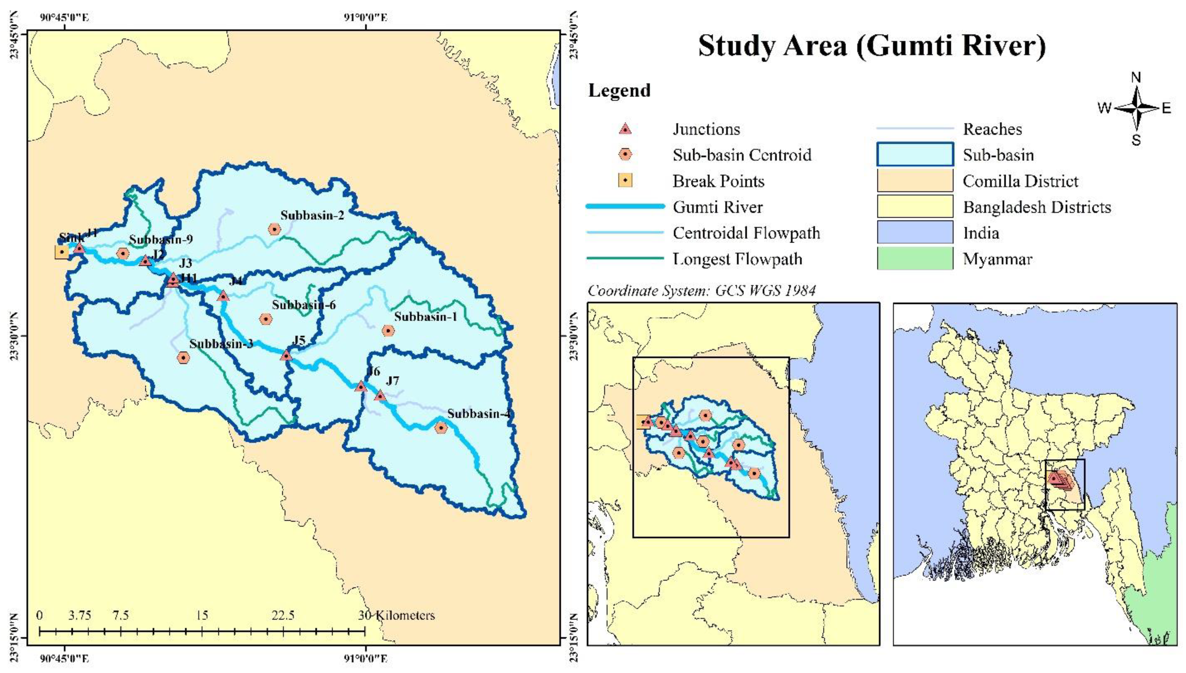
Figure 2.
Graphical representation of the meteorological data collected from various sources.
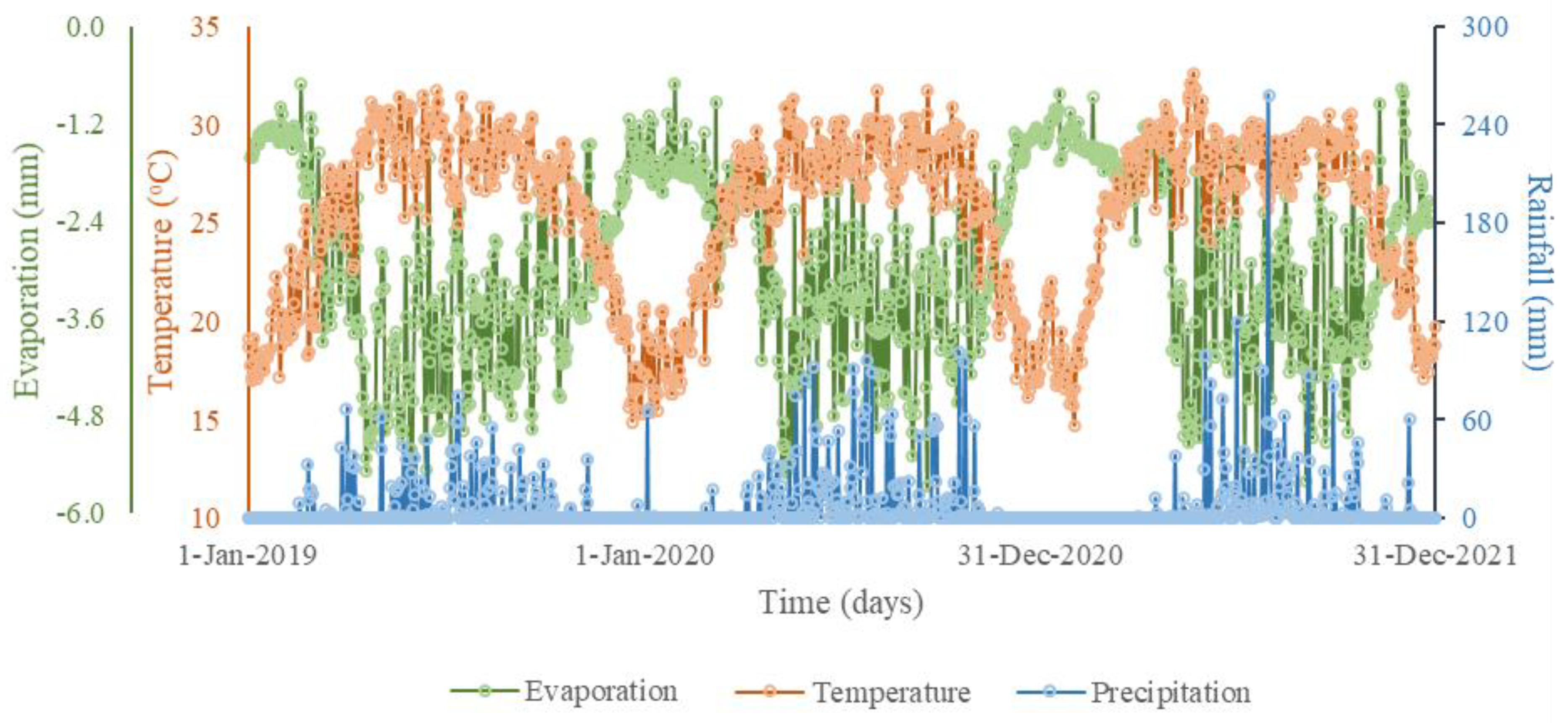
Figure 3.
Hydrologic model setup: (a) terrain generation, (b) preprocessing sinks, (c) preprocessing drainage, (d) stream identification and delineation.
Figure 3.
Hydrologic model setup: (a) terrain generation, (b) preprocessing sinks, (c) preprocessing drainage, (d) stream identification and delineation.
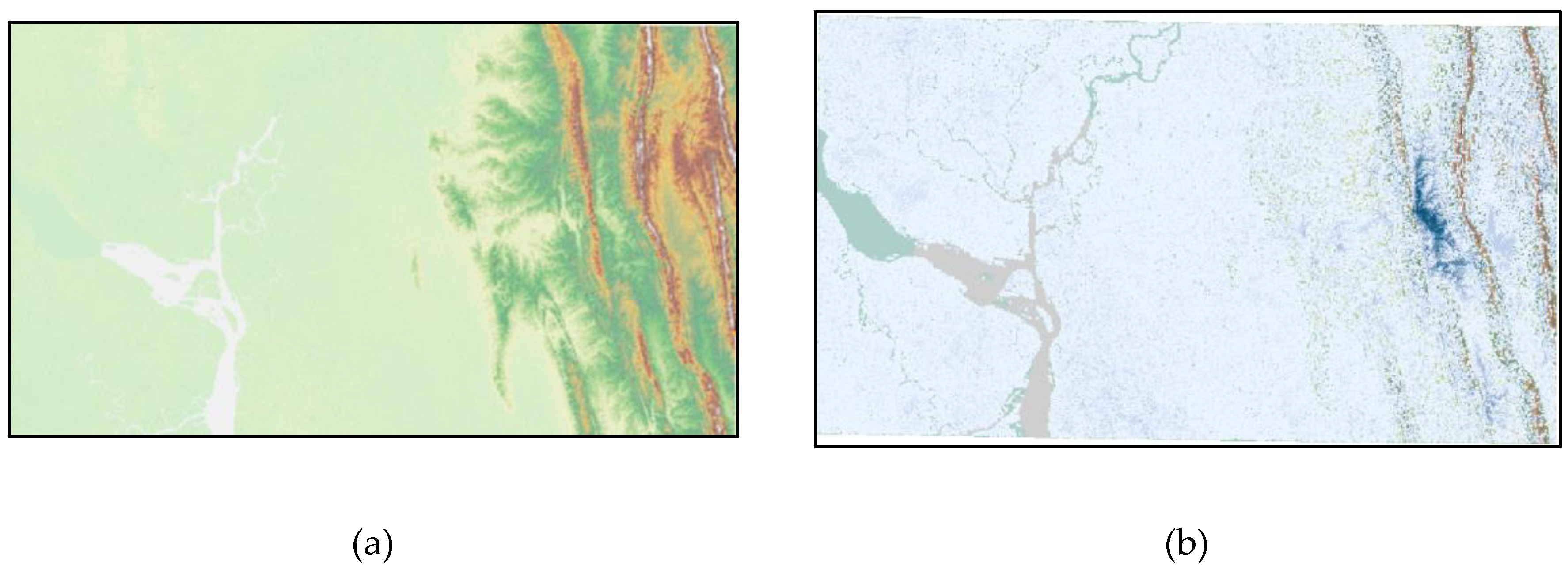
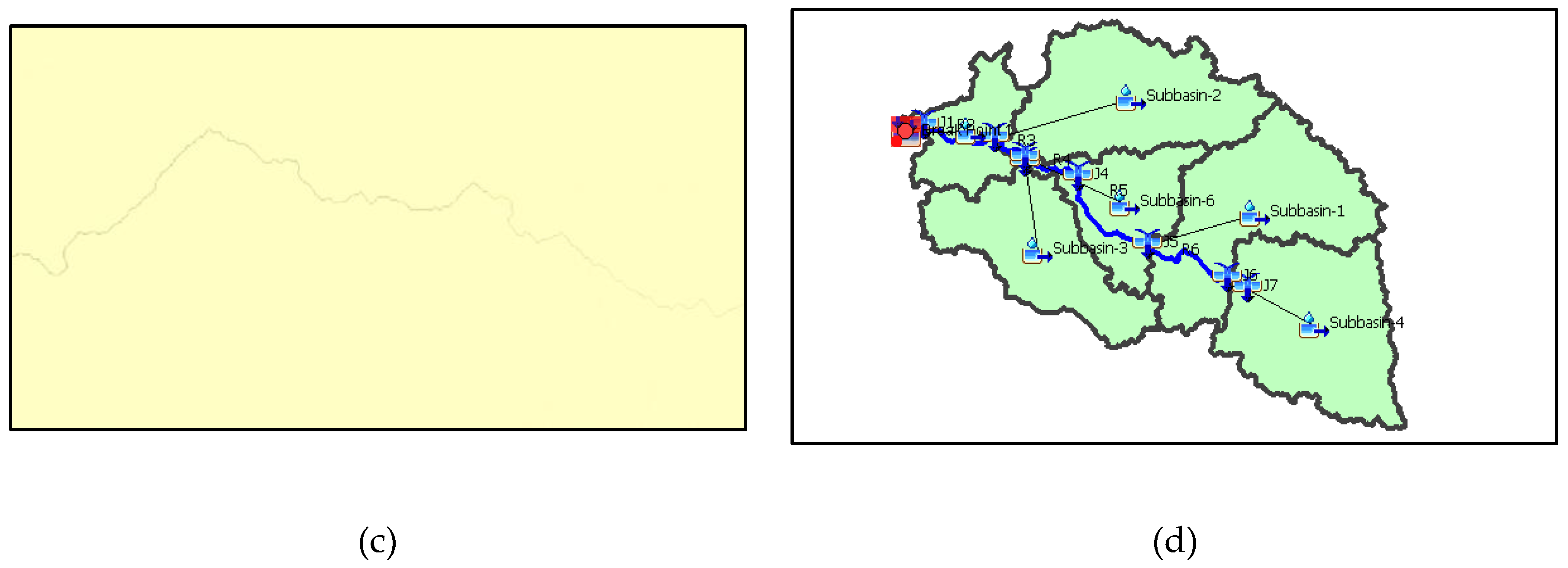
Figure 4.
Daily hydrograph comparison between simulated and observed flow for the Gumti river. (a) Calibration period (2019-2020), (b) Validation period (2021).
Figure 4.
Daily hydrograph comparison between simulated and observed flow for the Gumti river. (a) Calibration period (2019-2020), (b) Validation period (2021).
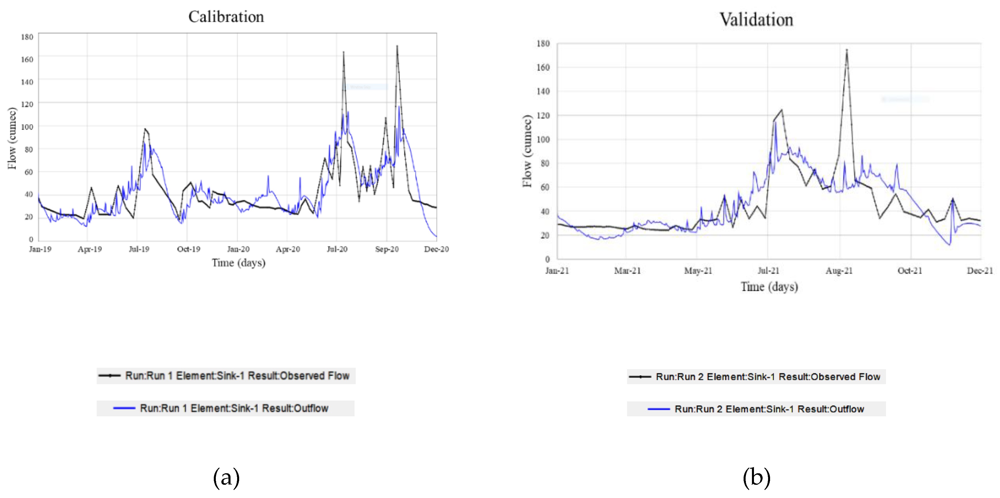

Table 1.
Summary of the selected tide stations along with their sources and data availability.
| Data Sources and References | Parameters | Station name with availability |
| Bangladesh Water Development Board (Daily) |
Discharge (m3/s) | Comilla (SW110) (January 01, 2019 – December 12, 2021) |
| Bangladesh Meteorological Department (Daily) |
Precipitation (mm), Temperature (oC) |
Comilla (January 01, 2019 – December 12, 2021) |
| ECMWF (Hourly) [21] | Evaporation (m of water equivalent) |
23°39'00"N, 90°41'24"E; 23°31'12"N, 90°15'00"E (January 01, 2019 – December 12, 2021) |
| USGS [22] | SRTM-DEM 1 arc-second for global coverage (~30 meters) | Whole Catchment Area (2018) |
Table 2.
Element and parameter set up in the HEC-HMS model with references.
| Model Element | Model Parameter | References |
| Canopy Method | Simple Canopy | Casulli [23], Minshall [24], Welle and Woodward [25] |
| Surface Method | Simple Surface | |
| Loss Method | SCS Curve Number | |
| Transform Method | SCS Unit Hydrograph | |
| Baseflow Method | Recession | |
| Routing Method | Muskingum | Ponce [26] |
Table 3.
Tested model parameters of canopy, surface and loss method for calibration and validation processes.
Table 3.
Tested model parameters of canopy, surface and loss method for calibration and validation processes.
| Canopy Method | Surface Method | Loss Method | ||||||||
| Simple Canopy | Simple Surface | SCS Curve Number | ||||||||
| Subbasin | Initial Storage (%) | Max Storage (MM) | Crop Coefficient | Evapotranspiration | Uptake Method | Initial Storage (%) | Max Storage (MM) | Initial Abstraction (MM) | Curve Number | Impervious (%) |
| Subbasin-4 | 10 | 60 | 1.00 | Wet and Dry Periods | Simple | 10 | 92 | 100.37 | 27.66 | 60 |
| Subbasin-1 | 10 | 60 | 1.00 | Wet and Dry Periods | Simple | 10 | 89 | 100.00 | 22.00 | 58 |
| Subbasin-3 | 10 | 60 | 1.00 | Wet and Dry Periods | Simple | 10 | 88 | 100.00 | 24.00 | 56 |
| Subbasin-6 | 10 | 60 | 1.00 | Wet and Dry Periods | Simple | 10 | 85 | 63.64 | 32.17 | 60 |
| Subbasin-2 | 10 | 60 | 1.00 | Wet and Dry Periods | Simple | 10 | 87 | 70.35 | 17.70 | 55 |
| Subbasin-9 | 10 | 60 | 1.00 | Wet and Dry Periods | Simple | 10 | 88 | 83.16 | 38.66 | 60 |
Table 4.
Tested model parameters transform and baseflow method for calibration and validation processes.
Table 4.
Tested model parameters transform and baseflow method for calibration and validation processes.
| Subbasin | Transform Method | Baseflow Method | |||||
| SCS Unit Hydrograph | Recession | ||||||
| Graph Type | Lag Time (MIN) | Initial Type | Initial Discharge (M3/S) | Recession Constant | Threshold Type | Ratio to Peak | |
| Subbasin-4 | Standard (PRF 484) | 408.88 | Discharge | 8 | 0.20 | Ratio to Peak | 0.3 |
| Subbasin-1 | Standard (PRF 484) | 765.96 | Discharge | 7 | 0.25 | Ratio to Peak | 0.3 |
| Subbasin-3 | Standard (PRF 484) | 596.19 | Discharge | 6 | 0.30 | Ratio to Peak | 0.3 |
| Subbasin-6 | Standard (PRF 484) | 524.94 | Discharge | 7 | 0.25 | Ratio to Peak | 0.3 |
| Subbasin-2 | Standard (PRF 484) | 748.33 | Discharge | 6 | 0.31 | Ratio to Peak | 0.3 |
| Subbasin-9 | Standard (PRF 484) | 408.49 | Discharge | 8 | 0.23 | Ratio to Peak | 0.3 |
Table 5.
Tested model parameters routing method for calibration and validation processes.
| Routing Method | ||||
| Muskingum | ||||
| Reach | Initial Type | Muskingum K (HR) | Muskingum X | Number of Subreaches |
| R7 | Discharge = Inflow | 133.15 | 0.07573 | 2 |
| R6 | Discharge = Inflow | 149.00 | 0.01100 | 2 |
| R5 | Discharge = Inflow | 149.00 | 0.00120 | 2 |
| R4 | Discharge = Inflow | 149.00 | 0.00125 | 1 |
| R11 | Discharge = Inflow | 149.00 | 0.02000 | 1 |
| R3 | Discharge = Inflow | 149.00 | 0.02000 | 1 |
| R2 | Discharge = Inflow | 149.00 | 0.01000 | 1 |
| R1 | Discharge = Inflow | 115.26 | 0.01802 | 1 |
Table 6.
General performance ratings for recommended statistics.
| Performance Rating | HEC [38] | Moriasi et al. [33] | ||||||
| R2 | RSR | NSE | PBIAS | R2 | NSE | PBIAS | ||
| Very good | 0.65 to 1.00 | 0.00 to 0.60 | 0.65 to 1.00 | <±15 | 0.75 to 1.00 | 0.75 to 1.00 | <±10 | |
| Good | 0.55 to 0.65 | 0.60 to 0.70 | 0.55 to 0.65 | ±15 to ±20 | 0.65 to 0.75 | 0.65 to 0.75 | ±10 to ±15 | |
| Satisfactory | 0.40 to 0.55 | 0.70 to 0.80 | 0.40 to 0.55 | ±20 to ±30 | 0.50 to 0.65 | 0.50 to 0.65 | ±15 to ±25 | |
| Unsatisfactory | <0.40 | >0.80 | <0.40 | >±30 | <0.50 | <0.50 | >±25 | |
Table 7.
Optimized model parameters.
| Optimized Parameter Results | |||||
| Basin Model: Basin 1 | Meteorologic Model: Met 1 | ||||
| Element | Parameter | Units | Initial Value | Optimized Value | |
| R7 | Muskingum - K | HR | 149.00 | 126.63 | |
| R7 | Muskingum - x | - | 0.01 | 0.03 | |
| Subbasin-4 | SCS Curve Number - Initial Abstraction | MM | 100.00 | 100.37 | |
| Subbasin-4 | SCS Curve Number - Curve Number | - | 40.00 | 27.66 | |
| Subbasin-9 | SCS Curve Number - Initial Abstraction | MM | 100.00 | 83.16 | |
| Subbasin-9 | SCS Curve Number - Curve Number | - | 40.00 | 38.66 | |
| Subbasin-6 | SCS Curve Number - Curve Number | - | 40.00 | 32.17 | |
| Subbasin-6 | SCS Curve Number - Initial Abstraction | MM | 100.00 | 63.64 | |
| Subbasin-2 | SCS Curve Number - Curve Number | - | 40.00 | 17.70 | |
| Subbasin-2 | SCS Curve Number - Initial Abstraction | MM | 100.00 | 70.35 | |
| R1 | Muskingum - K | HR | 149.00 | 115.26 | |
| R1 | Muskingum - x | - | 0.01 | 0.02 | |
Table 8.
Model Performance presented as Goodness-of-Fit Statistics for Calibration (01/01/19 – 12/31/20) and Validation period (01/01/21 – 12/31/21) of Gumti-Burinadi River. Data are presented with Default color codes for Statistics Reports [38].
Table 8.
Model Performance presented as Goodness-of-Fit Statistics for Calibration (01/01/19 – 12/31/20) and Validation period (01/01/21 – 12/31/21) of Gumti-Burinadi River. Data are presented with Default color codes for Statistics Reports [38].
| Peak Discharge (m3/s) | Volume (MM) | R2 1 | RSR 2 | NSE 3 | PBIAS 4 | |
| Calibration | 168.70 | 3674.89 | 0.64 | 0.60 | 0.585 | -2.59% |
| Validation | 174.80 | 1928.12 | 0.68 | 0.70 | 0.513 | -3.78% |
| Legend | ||||||
| Very Good | ||||||
| Good | ||||||
| Satisfactory | ||||||
| Unsatisfactory | ||||||
1 R2 = coefficient of determination; 2 RSR = root mean square error-standard deviation ratio; 3 NSE = Nash-Sutcliffe efficiency; 4 PBIAS = mean relative bias.
Disclaimer/Publisher’s Note: The statements, opinions and data contained in all publications are solely those of the individual author(s) and contributor(s) and not of MDPI and/or the editor(s). MDPI and/or the editor(s) disclaim responsibility for any injury to people or property resulting from any ideas, methods, instructions or products referred to in the content. |
© 2024 by the authors. Licensee MDPI, Basel, Switzerland. This article is an open access article distributed under the terms and conditions of the Creative Commons Attribution (CC BY) license (http://creativecommons.org/licenses/by/4.0/).
Copyright: This open access article is published under a Creative Commons CC BY 4.0 license, which permit the free download, distribution, and reuse, provided that the author and preprint are cited in any reuse.


