

Submitted:
02 August 2024
Posted:
02 August 2024
You are already at the latest version
Abstract
The environmental vulnerability diagnosis of a river basin depends on a holistic analysis of its environmental aspects and degradation factors. Based on this diagnosis, the definition of priority areas where interventions for environmental recovery should be carried out is fundamental, since financial and natural resources are limited. In this study, we developed a methodology to assess these fragilities using an Environmental Vulnerability Index (EVI) that combines physical and environmental indicators related to the natural sensitivity of ecosystems and their exposure to anthropogenic factors. The EVI developed was applied to the headwater’s region of the São Francisco River basin, Brazil. The proposed index was based on the AHP multi-criteria analysis and was adapted to include four variables representative of the study area: Land Use Adequacy, Burned Area, Erosion Susceptibility and Quantitative Water Balance. The EVI analysis highlighted that the presence of easily erodible soils, associated with sloping areas and land uses above their capacity, generate the most vulnerable areas in the headwaters of the São Francisco River basin. The results of this study indicate where resources should be applied for environmental preservation in the basin under study, directing the allocation of efforts to areas with lower resilience in maintaining ecosystem services.
Keywords:
multicriteria analysis
; GIS
; land use adequacy
; burned area
; erosion susceptibility
; water balance
1. Introduction
The conversion of soil cover through the exploitation of natural resources for the implementation of intensive and extensive farming systems has led to the fragmentation of natural environments and degradation processes over the last few decades [1,2]. The negative repercussions of this degradation, especially in areas where use was not aligned with their capabilities, include: a reduction in the diversity of flora and fauna; a reduction in the quantity and quality of water; and an intensification of erosion processes. In addition to the direct effects on the environment, soil and water degradation can also have harmful consequences for production capacity and the local socio-economy.
To reverse degradation in rural environments, it is essential to implement actions to restore natural environments or mitigate impacts, such as the use of soil and water conservation techniques in cultivated areas. However, there is a gap between the total area that can benefit from these actions and the resources available for this purpose. It is therefore crucial to use territorial intelligence analysis tools to identify vulnerable areas where the implementation of recovery or mitigation actions will enable the greatest preservation and, consequently, the greatest potential for maintaining or increasing desirable ecosystem services.
Environmental assessments can be obtained by mapping potential environmental vulnerability, which indicates the susceptibility of natural spaces to the occurrence of natural or induced degradation processes. Models of analysis of environmental vulnerability use simultaneous criteria (indicators) of the analyzed area, which are represented by layers of geographic data in the Geographic Information System (GIS) environment. Usually, a multi-disciplinary team supports these analyses [3,4,5].
Also, due to the complexity, nonlinearity, and multiplicity of dynamics of natural systems, development of sufficiently general indicators of environmental vulnerability may not be realizable [6]. Rather, environmental vulnerability development of indicators should be conducted at smaller scales and must be context-specific. In addition, knowing how to correctly convert data from multiple sources, such as climatic, land use and cover, soils and geomorphology properties into an integrated assessment index, is also vital step for vulnerability assessment.
Considering that the São Francisco River basin suffers from anthropogenic and climatic pressures, improving our knowledge of environmental vulnerability in the region has become fundamental to developing strategic plans to prioritize areas for environmental recovery and preservation, allocating resources efficiently. In this study, we proposed an Environmental Vulnerability Index (EVI) for the headwater’s region of the São Francisco River basin. This region is of great importance on the agricultural, social and environmental scene, with an essential role in providing water resources for energy generation, human consumption and irrigation, and has been threatened by the effects of environmental degradation.
2. Materials and Methods
2.1. Study Area
The São Francisco River is one of the most important in Brazil, with a length of 2,863 km and a drainage basin covers an area of more than 639,219 km², corresponding to 8% of the Brazilian territory. It runs from the state of Minas Gerais, where the river rises in the Serra da Canastra Mountain range, to the Atlantic Ocean, where it flows into the border between the states of Alagoas and Sergipe [7]. The basin’s drainage area covers the Northeast and Southeast regions of the country, covering 505 municipalities in six states. For this study, an area of 38,733.29 km2 was selected, which includes three sub-basins of the headwaters of the São Francisco River: the Paraopeba River sub-basin (12,191.07 km²), the Pará River sub-basin (12,095.23 km²) and the sub-basin of the initial section of the São Francisco River (São Francisco 01) (14,446.99 km²) (Figure 1).
The headwaters of the São Francisco River basin have significant portions of the area in the domains of the Cerrado biome (69%), located in the north of the area, and the Atlantic Forest (31%), present in the south of the area [8]. The predominant climate in the study area according to the Koppen classification is the Tropical Savannah (Aw), mainly in the northern region, where the Cerrado biome prevails. In the southern region, the Temperate, with dry winter and hot summer (Cwa) and Temperate, with dry winter and warm summer (Cwb) climates prevail, in areas that coincide with the Atlantic Forest biome [10]. In terms of soil class, most of the study area is covered by Ferralsols (47%), which are well-developed soils with a good effective depth, high total porosity and a strong degree of structural development. However, a large part of the basin is covered by Cambisols (34%), which are poorly developed soils, often covered by a gravelly floor on the surface, and which develop pronounced surface sealing [11].
2.2. Environmental Vulnerability Index (EVI)
The assessment of environmental vulnerability in a river basin is fundamental to its management, as it allows the identification of areas or resources at risk and the threats posed by the diminution or loss of such resources [11]. The study of environmental vulnerability can provide crucial information so that decision-makers can prioritize areas for the allocation of financial resources to implement alternative measures to reduce this vulnerability [12].
In general, vulnerability describes a system’s susceptibility to environmental stress or its lack of resilience [13]. Several studies have shown that environmental vulnerability can be linked to various factors such as: soil condition, terrain, vegetation, climatic and social economy [14,15,16]. However, there is no consensus on which variables should be used to establish the environmental vulnerability index for all sites, and in most cases the choice of variables is made through a specific assessment of the local physical and environmental characteristics.
Based on the literature, the available database and the region’s soil and climate conditions, four variables were selected as the main criteria for defining environmental vulnerability in the study area: Land Use Adequacy, Burned Area, Erosion Susceptibility and Quantitative Water Balance. The flowchart in Figure 2 presents the steps to estimate the environmental vulnerability index in the headwaters of the São Francisco River basin.
Each variable was represented by a spatial thematic layer derived from satellite images, official spatial data or data adapted by the authors. For the decision analysis, the values and classes of all the maps were rescaled from 0 to 1 using a linear function. In this way, the cells on a map with high environmental vulnerability were given standardized values close to 1 and the cells corresponding to the least vulnerable areas were given standardized values close to 0.
After standardization, the relative importance (final weights) of the criteria was obtained using the Analytical Hierarchy Process (AHP), and the maps of these criteria were multiplied in a GIS environment to obtain the final EVI map. Below is a description of the data sources and analysis procedures for each of the variables used as criteria for defining the environmental vulnerability index.
2.3. Multicriteria Analysis AHP
The Analytical Hierarchical Process (AHP) is a multi-perspective and multi-objective decision-making model that enables users and planners to quantitatively derive a scale of preference drawn from a set of alternatives [13]. In this way, experts can convert subjective judgments to objective measures [14].
The relative significance for each individual layer is resolved with Saaty’s 1-9 scale (Table 1), in which a score of 1 represents equal importance between the two variables, and a score of 9 shows the extreme importance of one variable in contrast to the other [15]. The Saaty scale is used to define the variables with their ranking scale and priority, which helps to organize them in hierarchical order through a pairwise comparison matrix.
In this study, the definition of scores based on the relative importance of each variable was carried out by specialists in water resources, pedology, geology, among others associated with the physical environment, based on their expertise and on the specialized literature.
The AHP method evaluates the probability of uncertainty in the pairwise comparisons through the principal eigen value and the consistency index [16]. The consistency index (CI) was calculated according to Equation 1.
Where λmax is the significant eigen value of the pairwise comparison matrix and n is the number of variables.
The consistency ratio (CR), used to check the consistency of the weights, indicates the probability that the values in the pair comparison matrix were randomly generated. According to [19], a matrix with a CR greater than 0.10 should be re-evaluated. The consistency ratio was calculated using Equation 2.
Where RI is the random index. The RI values associated with different numbers of variables (N) are shown in Table 1.
A comparison matrix between the variables was developed in pairs (Table 2). Using the AHP method, the weights assigned to each thematic layer were normalized, and the values were averaged to obtain the final weights (Table 2). The calculated CR value is within acceptable limits and shows the level of consistency of the pairwise matrix.
2.4. Collection of EVI Variables
2.4.1. Land Use Adequacy
The variable Land Use Adequacy expresses the relationship between land use capability and current land use intensity in each area. The land use capability indicates the maximum potential for use of the area, considering soil characteristics, relief and legal restrictions. This relationship directly impacts the environmental vulnerability of a given area, since in places where the current land use intensity exceeds the supported use capability, there is a tendency for degradation of the physical and biotic environment with potential damage that is sometimes difficult to reverse, resulting in the unfeasibility of using the area.
The land use capability classes (LUC) follow an increasing order of limitation, ranging from I to VIII, being the Class I lands those with greater resilience to more intensive uses and the Class VIII lands those with less resilience and therefore intended for less intensive uses. The determination of the land use capability class is the product, therefore, of an integrated analysis of the intrinsic characteristics of the soils, the relief [21] and the legal aspects of protection of native vegetation, as presented in Table 3.
Regarding the soil, the ranking in the land use capability classes was performed from the grouping of the pedological units in the second categorical level (large groups) of the Brazilian Soil Classification System (SiBCS) [22] based on the following factors: effective depth, texture, internal drainage, flood risk, and apparent/natural fertility, as shown in Table 4. For the soil’s classification, the pedology map of Brazil at the scale of 1:250,000 provided by the Brazilian Institute of Geography and Statistics [10] was used.
Regarding the relief, the slope, which is one of the parameters that most interferes in the balance between the water that infiltrates or drains superficially into the soil, was subdivided into 8 intervals of land use capability classes (Table 4), as proposed by [23]. The slope map was calculated using the Digital Elevation Model (DEM) of the study area, obtained from NASADEM images, with 30 m resolution [24].
As for the legal aspects, we considered the limitations of use in water Permanent Preservation Areas (PPA) (springs and streams) and Legal Reserve Areas (areas self-declared in the Rural Environmental Registry - CAR), imposed by the Brazilian Law of protection of native vegetation (Law 12.651/2012), being assigned to these areas the land use capability class VIII. The permanent preservation areas were obtained from the mapping done by the Brazilian Foundation for Sustainable Development on a scale of 1:25,000 [21] and the Legal Reserve Areas were obtained from the landowners’ registrations in the CAR [22].
The land use capability class (LUC) was then defined as that corresponding to the limiting factor between the criteria related to soil, relief and legal aspects, i.e., for a given area, the value of land use capability corresponds to the highest capability class value presented for the three criteria.
For the assessment of land use intensity, we utilized land use and land cover mapping of the study area, obtained from Collection 6 of the Annual Mapping of Land Use and Land Cover in Brazil Project, MapBiomas, published in August 2021, which presents data on land use and land cover in 2020 [8]. The use and cover variable indicates how the land is being used and can be considered an indicator of current land use intensity (LUI), when the use classes are associated with different weights. Thus, the current land use intensity class was defined from the current land use and land cover (LULC) map, as classified in Table 5.
Based on the land use capability class (LUC) and the land use intensity (LUI), obtained previously, the number of exceeding classes (NCE) was determined, which represents how much the land is being used in relation to its capacity (Equation 3).
Where NCE = number of exceeding classes; LUC = land use capability class, dimensionless; and LUI =land use intensity, dimensionless.
As there are eight land use capability classes in the classification system used, the equation allows for results ranging from 7 to -7, with positive, negative, and null results indicating, respectively, that the soil is being used above, below, and in accordance with its use capability. The negative values were converted to null, as they are not considered vulnerable areas, since they are being used below their capacity, and the values of the adequacy classes from 0 to 7 were converted to a scale from 0 to 1, to standardize with the other maps used in the AHP multicriteria analysis.
2.4.2. Burned Area
Fire can be extremely damaging to sensitive ecosystems such as the Atlantic Rainforest, while maintaining the structure and composition of Cerrado environments. This is because, historically, Atlantic Forest species have not been subjected to recurrent fires that required physiological and structural adaptations for survival. While in the Cerrado, fire is a natural component that has shaped the evolution of species for thousands of years [23].
Despite being a natural component of the Cerrado, the intense process of human intervention in the environments has altered the origins of fire and subjected ecosystems to frequencies and intensities of disturbance to which species are probably not adapted [24]. Therefore, fire is a significant source of environmental degradation in river basins with an advanced process of anthropization, as is the case in the of the São Francisco River basin. Thus, studying and evaluating the occurrences of fires in this basin is fundamental to mitigating the impacts on fauna, flora and soil properties.
The burned areas were evaluated using the fire scars maps of Brazil for the period of 2011 to 2020, developed by MapBiomas, from Landsat satellite images, with 30 m spatial resolution, available on the project’s website [25]. The map of fire scars for each year were summed to assess the recurrence of fires in the ten-year period (2011 to 2020). Thus, the areas that did not burn at all during the analyzed period received a value of zero, and the remaining areas, which burned at least once, received values between 1 and 10, depending on the number of years in which the fires recurred in the period. Subsequently, the recurrence values of the burned areas were converted to a scale of 0 to 1, to standardize with the other maps used in the AHP multicriteria analysis.
2.4.3. Erosion Susceptibility
Human activity and changes related to land use are the main causes of accelerated soil erosion, which has substantial implications for the nutrient and carbon cycle, the productive capacity of the land and, consequently, the socio-economic conditions of river basins [30]. Therefore, to mitigate erosion processes, it is necessary to know about soil types, topography, natural or artificial drainage and slope stability conditions, in order to adapt the soil cover to each specific situation.
In this context, one of the ways of providing subsidies for the selection of priority areas for conservation and recovery of native vegetation is the use of spatialized maps of natural soil erosion potential. In this study, a methodology was proposed for obtaining the erosion susceptibility map for the headwaters of the São Francisco River basin by means of the weighted average of the rainfall erosivity (R), soil erodibility (K) and slope (S), scaled from 0 to 1. According to the characteristics of the study area, the expertise of the authors, and simulations carried out with different combinations of weights, the weights shown in Equation 4 were considered, where soil erodibility is twice as important as the other parameters considered when calculating erosion susceptibility (ES).
Where ES = erosion susceptibility; R = rainfall erosivity factor map; K = soil erodibility factor map; and S = slope map, all rescaled to a scale of 0 to 1.
2.4.4. Rainfall Erosivity (R)
Rainfall erosivity expresses the capacity of rainfall expected in a given location to cause erosion on bare soil [26]. It is related to the impact of the drops which, due to their kinetic energy, break down the soil aggregates, making them lighter and more susceptible to being washed away by surface runoff. The rainfall erosivity map was obtained by adding up the monthly values of the erosion indices (R), which were calculated using Equation 5 proposed by [27].
Where p = average monthly rainfall; and P = average annual rainfall.
The rainfall data needed to apply this equation was obtained from TerraClimate for the period from 2001 to 2020 [28]. The erosivity map was then rescaled from 0 to 1 to standardize the scale with the other erosion susceptibility maps.
2.4.5. Soil Erodibility (K)
Soil erodibility represents the susceptibility of a given type of soil to erosive processes, i.e. the ease with which soil particles are detached and transported by the impact of raindrops and surface runoff [34,35]. This characteristic is related to the soil’s physical properties, such as texture, structure, density and permeability, as well as the soil’s chemical, biological and mineralogical properties [36].
The soil erodibility map was obtained by analyzing the existing soil classes, weighted by the lithological units of the geology maps [10], with susceptibility values ranging from 1 to 5, as shown in Table 3. These values were assigned based on the criteria for assessing the erosion potential of the different Brazilian soils proposed by [37,38]. The final weight of soil erodibility was calculated by the weighted average between the weights of the soil class and the geological component, according to Equation 6.
Where: K = soil erodibility factor; WKS = weight of the soil component in the soil erodibility factor; WKG = weight of the geological component in the soil erodibility factor.
2.4.6. Slope (S)
Relief is another aspect of fundamental importance in understanding and quantifying the erosion process, with slope and slope length being the main relief variables related to erosion. The greater the slope, under the same soil and rainfall conditions, the smaller the volume of water that effectively infiltrates the soil and, consequently, the greater the volume and energy associated with runoff [34]. The influence of the relief on susceptibility to erosion can be represented by the slope of the land.
In this work, the slope map was calculated using the Digital Elevation Model (DEM) of the study areas, obtained from NASADEM images with a resolution of 30 m [20]. This map was then rescaled from 0 to 1 to standardize the scale with the other erosion susceptibility maps.
2.4.7. Quantitative Water Balance
The quantitative water balance is of fundamental importance for the diagnosis of the level of water commitment in river basins, being carried out in Brazil by river reach and by micro basin by the National Water and Basic Sanitation Agency (ANA). Its role is to identify how much of the available water is being used to satisfy consumptive uses. This is given by the ratio between demand and supply and is presented in terms of percentage of impairment.
The demand corresponds to the sum of the estimated withdrawal flows for the various sectoral consumptive uses, associated with their place of use and without distinction between surface and underground uses. An exception applies to urban supply, whose flow was associated with the withdrawal point, and only the surface portion was accounted for. The supply, in turn, corresponds to a high guaranteed flow rate, defined as water availability, and aggregates the Q95 flow rate (flow rate with permanence at 95% of the time) and the additional flow offered by reservoirs, according to their operating mode [35].
The current data distributed in micro basins was constructed in a scenario of current water balance, with demands for 2020. In this scenario, the water balance was carried out by river reach, classifying the level of water commitment of the reaches as: low (below 5%), medium (5% to 30%), high (30% to 70%), very high (70% to 100%), critical (above 100%) and intermittent (zero supply) [35].
For its use in the AHP multicriteria analysis, the quantitative water balance values were converted to a scale of 0 to 1, to standardize with the maps of the other variables, where the value 1 was assigned to critical micro basins and zero to those with low commitment.
3. Results and Discussion
3.1. Environmental Vulnerability Index (EVI)
3.1.1. Land Use Suitability
The land use capability was defined as the variable corresponding to the limiting factor between the criteria related to soil, relief and legal aspects, that is, for a given area, the value of land use capability corresponds to the highest value of the capability class presented for the three criteria. Figure 3a presents the land use capability map of the studied basin, in which it is possible to observe that land use capability classes II, III, VII and VIII are those that predominate in the basin, corresponding together to about 90.2% of its total area.
A large part of the headwaters of the São Francisco River basin, 49.8% of the total area, fell into classes VII and VIII, i.e., lands with very severe limitations, unsuitable for crops and of restricted use for pastures, planted forests and refuge for wild flora and fauna, or even with limitations that prevent their use for any agricultural activity, restricting them to recreation and/or protection of wild flora and fauna or even water storage. It is also observed that 20.1% of the areas were classified as class II, which are those lands suitable for crops with simple conservation practices, while 20.3% were classified as class III, which are lands suitable for crops with intensive or complex conservation practices. The remaining areas, about 9.8% of the basin, were classified as classes I, IV, V and VI.
The classification of the current land use map of the study area generated the land use intensity map (Figure 3b). According to the proposed classification, about 26.6% of the basin area is currently with intensity of use in classes I and II, which are considered the most intense use classes, related to agriculture, mining and non-vegetated areas. About 45% of the basin is in class III, related to the presence of pastures, while 28.4% is in classes VI and VIII, which are considered less intense when compared to the other classes, and are associated with natural formations and silviculture.
The number of exceeding classes was calculated as the subtraction of the land use intensity (LUI) from the land use capability class (LUC), representing how much the land is being used beyond its capacity. Figure 4 presents the map of exceeding land use capability classes in the headwaters of the São Francisco River basin, in which it is possible to observe that approximately 49.4% of the studied basin area presents land use intensity below or equal to the use capability, while 50.6% of the basin area presents use intensity above the capability, with 33.5% of the areas exceeding four to six classes of use intensity.
The areas with the highest number of exceeding classes are located mostly in the western region of the basin and are associated mainly to areas with highly erodible soils, such as Leptsols and Cambisol with high slopes, being used for uses such as pastures and agriculture. The combination of these three parameters represents the most intensive scenario in the region, exerting the greatest pressure and resulting in the worst situation in terms of land use. We also observe areas with a high number of exceeding classes in areas protected by legal aspects, such as legal reserve areas (LR) and permanent preservation areas (PPA), which have current use diverging from that defined by law. For the application of the AHP multicriteria analysis this map was later converted into a common scale from 0 to 1, in order to standardize with the other maps.
3.1.2. Burned Area
The recurrence map of burned areas in the headwaters of the São Francisco River basin (Figure 5) shows that 95.98% of the area of the headwaters has not been burned in the last ten years, and only 4.0% of the area has been burned during this period. In 1.0% there was a recurrence of fires, i.e. places where fires were detected in two or more years within the period analyzed. The detection of fires in the same region occurred in up to seven of the ten years analyzed. In general, however, the environmental vulnerability of the headwaters of the São Francisco River basin was low in terms of burnt areas during the period analyzed.
It can be seen that the highest frequency of fires is found in areas in the far west of the basin, in the Serra da Canastra National Park, where the vegetation formed by the grassy stratum of the grassland formations tends to dry out during periods of drought and favors the spread of fires in the region. Other areas of fires coincide with the route of roads and proximity to large urban centers in the Paraopeba basin, corroborating other studies that show high incidences of fire ignitions caused by human actions around accessibility networks [36,37,38].
3.1.3. Erosion Susceptibility
Rainfall erosivity in the headwaters of the São Francisco River basin varied between 5,646 and 7,006 MJ mm-1 ha-1 h-1 year-1 and its pattern is mainly associated with the distribution of rainfall in the basin (Figure 6a), with the highest rainfall erosivity values, above 6,500 MJ mm-1 ha-1 h-1 year-1, being found in the southeast of the basin, mainly in the highest and steepest parts, related to the western edge of the province known as Quadrilatero Ferrifero, one of the richest mineral-bearing regions in the country, more specifically along the Azul and Moeda mountain ranges.
Figure 6b shows the map of soil erodibility in the headwaters of the São Francisco River basin. The areas with the highest soil erodibility are located mainly in the eastern and central regions of the headwaters and are mainly related to the presence of Cambisols on Neoproterozoic pelitic rocks belonging to the Bambuí Group. These sedimentary rocks, which are often stratified parallel to the surface, show a certain resistance to weathering and thus lead to the occurrence of poorly developed soils such as Cambisols and, to a lesser extent, Leptsols. These soils are often covered by a gravelly surface and develop pronounced surface sealing. The combination of these two characteristics makes them highly susceptible to erosion, as they hinder water infiltration and, consequently, the growth of larger vegetation. In these areas, the predominance of surface runoff over infiltration, combined with the predominant use of extensive pastures, leads to intense erosion processes.
On the western edge of the headwaters, there is also an extensive area with high erosion susceptibility. As in the central region, these are pelitic and metapelitic rocks (siltstones, shales and slates), also belonging to the Bambuí Group. However, on this western edge, the stratigraphy of these rocks is practically perpendicular to the surface, representing a border region, folded by post-Proterozoic metamorphic processes. This is because it is the contact zone between these sedimentary layers, which lie on the crystalline rocks of the São Francisco craton, and the metamorphic rocks of the southern portion of the Brasília-Tocantins Mobile Belt. This contact is expressed by a gap, locally known as Saudade mountain, which separates two dissected plateaus. In these areas, erosion processes are very intense and the high slope gradients are added to the soil’s intrinsic characteristics.
Another important area with high susceptibility to erosion is in the extreme southeast of the basin and is represented by the western flank of the Quadrilátero Ferrífero geological province. This is an intensely folded area, consequently with a very steep terrain, where shallow and poorly developed soils predominate, such as Cambisols and Leptsols sitting on metamorphic rocks, such as phyllites, schists, itabirites, quartzites and others.
The main relief classes found in the headwaters of the São Francisco River basin are wavy (43.8%) and gently wavy (26.7%), strongly wavy (16.9%) (Figure 6c). The mountainous and steep terrain occupies only 1.1% of the area of the headwaters and the plain terrain is present in 11.5% of the total area. The flat part of the basin’s headwaters is mainly located on the strip close to the right bank of the São Francisco River. This relief, predominantly smoothed, reduces the susceptibility to erosion processes, even with the predominance of pastures as the main land cover. Areas with a slope of over 45% are associated with mountain regions, such as the Moeda, Azul, Canastra and Saudade mountains.
The susceptibility to erosion in the São Francisco River basin (Figure 7) was obtained through the product of the rainfall erosivity, soil erodibility and slope, using Equation 4. The areas with the greatest susceptibility to erosion are those located in the western and southeastern parts of the basin, where there are the highest rainfall rates and the pedological units with the greatest susceptibility to erosion, such as Cambisols and Leptsols. In the southeast of the basin, there are areas of greater slope associated with Paleoproterozoic geological formations, linked to the Quadrilatero Ferrifero province. In the extreme southwest, the presence of areas of high slope are linked to rocks of the Araxá Group of Neoproterozoic age. Along the western edge and in the center of the basin, the areas of greater slope, and consequently more susceptible to erosion, are linked to the presence of pelitic and metapelitic rocks of the Bambuí Group, also of Neoproterozoic age, on which shallow soils develop, where the processes of surface runoff take precedence over infiltration and pedogenesis.
3.1.4. Quantitative Water Balance
The quantitative water balance in the headwaters of the São Francisco River basin (Figure 8), provided by [35], shows that around 93.7 % of the basin area has excellent or comfortable water availability. In the remaining 6.3% of the area, availability was classified as worrying, critical or very critical. For the headwaters of the São Francisco River basin, the sub-basins with very critical water availability are mainly located near urban centers, where the demands for human supply and industrial uses are higher.
3.1.5. EVI
After standardizing the environmental variables on a scale of 0 to 1, they were multiplied using map algebra, applying the weights in Table 2, generating the final map of the Environmental Vulnerability Index (EVI) in the headwaters of the São Francisco River basin (Figure 9). The map was subdivided into 5 classes of equal area according to the value of the EVI, namely: very low, low, medium, high and very high. The areas with the highest EVI values are mainly related to areas with shallow and easily erodible soils, such as Leptsols and Cambisols, associated with areas with high slopes, being used predominantly for pasture and, to a lesser extent, for agricultural plantations. This combination of parameters, as previously mentioned, accentuates environmental vulnerability. It represents the most intensive scenario with the greatest environmental pressure.
Since the Brazilian colonial period, the São Francisco River basin has been used for extensive cattle raising, mining, and the implementation of large steel industrial action, promoting the clearing of native vegetation from the land for charcoal production. More recently, increases in agricultural production, mainly soybean, corn, and sugarcane, have been observed, leading to intensified land clearing and associated to the increased soil erosion rates. According to [40], in 2022, the deforested area in the headwaters of the São Francisco River basin was 3444.5 ha, of which 2660.3 ha (77.2%) were in the Cerrado, while 784.2 ha (22.8%) were in the Atlantic Forest.
The EVI values were also high in the areas with the highest number of exceeding classes, in areas protected by legal aspects, such as Water PPAs and Legal Reserves, which currently have more intensive uses than defined by law, such as pasture, exposed soil and crops. Areas close to conservation units and indigenous lands also showed high EVI values, indicating human pressure in the fully protected areas (Figure 9). A similar result was found by [39] analyzing the environmental vulnerability of the São Francisco River basin to drought conditions and land degradation. They found that that for entire São Francisco River basin, the highest vulnerability values occurred within a 5 km buffer in relation to the Conservation Units, representing approximately 32.4% of the total area.
Also noticeable in the areas with high EVI values is the influence of the critical and very critical sub-basins in relation to water availability, located in the north-central and extreme eastern regions of the basin, the latter being related to the large urban centers of the Belo Horizonte metropolitan region. The municipality of Belo Horizonte alone serves 2,402,829 inhabitants with treated water, with an average consumption of 156.5 l/person.day [41], which has a direct impact on the water availability of the tributaries of the São Francisco River, especially of the Paraopeba River.
The Burned Area variable received a lower weight than the other variables (6.1%), which reflects its lower influence on the final EVI map. However, areas with higher fire frequency, mainly in the western region of the basin near Serra da Canastra, and in the eastern region near the Quadrilatero Ferrifero province, coincide with high EVI areas. In these regions, altitudes are mostly above 1000 m, with the presence of natural vegetation, such as high-altitude grasslands and rocky fields, dominated by shrubs and grasses.
Regular fires are part of these ecosystems due to the microclimatic conditions associated with altitude and the type of vegetation present, as well as the proximity of human activities that make these environments prone to fires. The predominant vegetation, composed of grasses and shrubs, provides highly flammable fuel, facilitating fire spread. Additionally, climatic conditions such as high temperatures, low humidity, and frequent winds create a favorable environment for fire ignition and propagation [35].
It can also be seen in Figure 9 that the areas with the highest environmental vulnerability indices are in the west and southeast of the headwaters of the São Francisco River basin, in the São Francisco 01 and Paraopeba sub-basins, respectively. This result makes it possible to select priority areas for intervention where the implementation of recovery or mitigation actions will enable the greatest preservation and, consequently, the greatest potential return of desirable ecosystem services. In countries like Brazil, where the scarcity of resources limits environmental preservation actions, it is extremely important to identify the areas where recovery measures are most needed, to effectively allocate the available funds.
5. Conclusions
In recent decades, several socio-environmental indices have been proposed in Brazil, most of them related to natural threats, such as disasters related to flood risk in metropolitan areas [42,43], or to anthropogenic threats, such as disasters related to mining dam ruptures [44]. But few indices have proposed a global application with the aim of indicating areas for environmental recovery and none of these have been applied to the São Francisco River basin.
In this paper, we present a new approach to characterizing and quantifying environmental vulnerability, integrating geospatialized indicators of specific importance to the study area, considering relief, hydrology, pedology, geology, climate and land use aspects. Four variables were selected as the main criteria for defining the environmental vulnerability index (EVI): Land Use Adequacy, Burned Area, Erosion Susceptibility and Quantitative Water Balance. We presented a well-established approach in the literature for defining the environmental vulnerability index, applying the AHP multi-criteria analysis, with the expertise of various Brazilian specialists in the fields of pedology, geology, hydrology and natural sciences, to understand the spatial variability of environmental vulnerability in the study area, which is representative of the Cerrado and Atlantic Forest biomes.
The EVI was applied to the headwaters of the São Francisco River basin, and we observed that, according to the AHP analysis, the factors Land Use Adequacy and Erosion Susceptibility had the greatest influence on environmental vulnerability in the headwaters of the São Francisco River basin, together explaining 83.6% of the EVI, while the factors Quantitative Water Balance and Burned Areas had less influence on the final index.
The areas with the greatest EVI are mainly related to the presence of shallow and easily erodible soils, such as Leptsols and Cambisols, associated with areas with steep slopes and used predominantly as pastures and agricultural crops. This combination of parameters represents the most intensive scenario, with the greatest environmental pressure. In addition, high EVI values are found in the areas with the highest number of exceeding classes of land use, also related to erodible soils, sloping areas and legal reserve and permanent preservation areas used as pasture, exposed soil and agricultural crops. High EVI values are also related to very critical and critical basins in terms of water availability, located close to urban centers.
A major contribution of this study is the identification of an environmental vulnerability index, considering the regional climate, fire, soil susceptibility to erosion, land use dynamics and legal aspects. This assessment can support government and private environmental recovery programs, by providing information related to the exposure and sensitivity of natural systems. The results of this work can help to identify areas where conservation and recovery practices have the greatest potential to increase ecosystem services, as well as contributing to water security in the face of the demands of urban centers and agricultural activities, thus inducing a balance between the use and conservation of natural resources.
Author Contributions
Conceptualization, C.C., D.S. and R.A.; methodology, C.C., B. N., E.P, E.F., P.B.; software, C.C., L.V.; validation, D.S, R.A. and E.F.; formal analysis, C.C and E.P.; investigation, C.C., E.P. and P.B.; resources, J.F.; data curation, C.C, E.P.,R.A., P.B and E.F.; writing—original draft preparation, C.C.; writing—review and editing, C.C., R.A, E.P. and B. N..; visualization, C.C.; supervision, J.F.; project administration, J.F.; funding acquisition, D.S. and J.F. All authors have read and agreed to the published version of the manuscript.
Funding
Please add: This research was funded by Ministério da Integração e do Desenvolvimento Regional (MDR) and Conselho Nacional de Desenvolvimento Científico e Tecnológico (CNPq), grant number 150171/2022-6.
Data Availability Statement
The raw data supporting the conclusions of this article will be made available by the authors on request.
Acknowledgments
The authors would like to express their gratitude to Conselho Nacional de Desenvolvimento Científico e Tecnológico (CNPq), Coordenação de Aperfeiçoamento de Pessoal de Nível Superior (CAPES) e Ministério da Integração e do Desenvolvimento Regional (MDR), for the financial support for the project under which this research was carried out.
Conflicts of Interest
The authors declare no conflicts of interest.
References
- Pompeu, J.; Assis, T.O.; Ometto, J.P. Landscape Changes in the Cerrado: Challenges of Land Clearing, Fragmentation and Land Tenure for Biological Conservation. Science of the Total Environment 2024, 906. [CrossRef]
- Vancine, M.H.; Muylaert, R.L.; Niebuhr, B.B.; Oshima, J.E. de F.; Tonetti, V.; Bernardo, R.; De Angelo, C.; Rosa, M.R.; Grohmann, C.H.; Ribeiro, M.C. The Atlantic Forest of South America: Spatiotemporal Dynamics of the Vegetation and Implications for Conservation. Biol Conserv 2024, 291. [CrossRef]
- Padilha, D.G.; Luiz Trevisan, M.; Cabral Cruz, J. Sensibilidade Do Modelo de Fragilidades Ambientais à Ponderação Multicriterial: Aspectos Físicos Da Bacia Hidrográfica Do Alto Uruguai. Floresta 2014, 44, 535–548.
- Peruchi Trevisan, D.; da Conceição Bispo, P.; Almeida, D.; Imani, M.; Balzter, H.; Eduardo Moschini, L. Environmental Vulnerability Index: An Evaluation of the Water and the Vegetation Quality in a Brazilian Savanna and Seasonal Forest Biome. Ecol Indic 2020, 112. [CrossRef]
- Akintan, O.B.; Olusola, J.A.; Imole, O.P.; Adeyemi, M.O. Geotechnical and GIS-Based Environmental Factors and Vulnerability Studies of the Okemesi Landslide, Nigeria. Regional Sustainability 2023, 4, 249–260. [CrossRef]
- Beroya-Eitner, M.A. Ecological Vulnerability Indicators. Ecol Indic 2016, 60, 329–334. [CrossRef]
- CBHSF. The River Basin. Available online: https://cbhsaofrancisco.org.br/a-bacia/ (accessed on 30 July 2024).
- MapBiomas Método MapBiomas Fogo. Projeto MapBiomas 2021. Available online: https://mapbiomas.org/metodo-mapbiomas-fogo-1 (accessed on 05 outubro 2023).
- Beck, H.E.; McVicar, T.R.; Vergopolan, N.; Berg, A.; Lutsko, N.J.; Dufour, A.; Zeng, Z.; Jiang, X.; van Dijk, A.I.J.M.; Miralles, D.G. High-Resolution (1 Km) Köppen-Geiger Maps for 1901–2099 Based on Constrained CMIP6 Projections. Sci Data 2023, 10. [CrossRef]
- IBGE Pedologia 1:250.000 Available online: https://www.ibge.gov.br/geociencias/informacoes-ambientais/pedologia/10871-pedologia.html?=&t=downloads (accessed on 26 November 2023).
- Wang, S.Y.; Liu, J.S.; Yang, C.J. Eco-Environmental Vulnerability Evaluation in the Yellow River Basin; 2008; Vol. 18.
- IPCC Climate Change 2001: The Scientific Basis; New York, 2011.
- Fuchs, S.; Birkmann, J.; Glade, T. Vulnerability Assessment in Natural Hazard and Risk Analysis: Current Approaches and Future Challenges. Natural Hazards 2012, 64, 1969–1975. [CrossRef]
- Vieira, R.M. da S.P.; Tomasella, J.; Cunha, A.P.M. do A.; Barbosa, A.A.; Pompeu, J.; Ferreira, Y.; Santos, F.C.; Alves, L.M.; Ometto, J. Socio-Environmental Vulnerability to Drought Conditions and Land Degradation: An Assessment in Two Northeastern Brazilian River Basins. Sustainability (Switzerland) 2023, 15. [CrossRef]
- Luo, D.; Caldas, M.M.; Goodin, D.G. Estimating Environmental Vulnerability in the Cerrado with Machine Learning and Twitter Data. J Environ Manage 2021, 289. [CrossRef]
- Zhao, J.; Ji, G.; Tian, Y.; Chen, Y.; Wang, Z. Environmental Vulnerability Assessment for Mainland China Based on Entropy Method. Ecol Indic 2018, 91, 410–422. [CrossRef]
- Saaty, T.L.; Shang, J.S. An Innovative Orders-of-Magnitude Approach to AHP-Based Mutli-Criteria Decision Making: Prioritizing Divergent Intangible Humane Acts. Eur J Oper Res 2011, 214, 703–715. [CrossRef]
- Sipahi, S.; Timor, M. The Analytic Hierarchy Process and Analytic Network Process: An Overview of Applications. Management Decision 2010, 48, 775–808.
- Saaty, T.L. The Analytic Hierarchy Process. McGraw-Hill 1980.
- Saaty, T.L. Decision Making with the Analytic Hierarchy Process; 2008; Vol. 1.
- Lepsch, I.F.; Espindola, C.R.; Vischi Filho, O.J.; Hernani, L.C.; Siqueira, D.S. Manual Para Levantamento Utilitário e Classificação de Terras No Sistema de Capacidade de Uso; 1st ed.; Sociedade Brasileira de Ciência do Solo: Viçosa, MG, 2015; Vol. 1.
- EMBRAPA Sistema Brasileiro de Classificação de Solos; Brasília, DF, 2018.
- Monteiro, L.I.B.; Pruski, F.F.; Calegario, A.T.; Oliveira, A.N.G.; Pereira, S.B. Methodology for Payment for Ecosystem Services Based on the Concept of Land Use and Management Capability. Soil Use Manag 2018, 34, 515–524. [CrossRef]
- NASA NASADEM Merged DEM Global 1 Arc Second V001 Available online: https://catalog.data.gov/dataset/nasadem-merged-dem-global-1-arc-second-v001> (accessed on 4 November 2022).
- FBDS Permanent Preservation Areas Available online: http://geo.fbds.org.br (accessed on 8 October 2023).
- CAR Legal Reserves Available online: https://www.car.gov.br/#/ (accessed on 8 October 2023).
- MapBiomas Coleção 6 Da Série Anual de Mapas Da Cobertura e Uso Do Solo Do Brasil Available online: https://mapbiomas.org/ (accessed on 4 October 2022).
- Berlinck, C.N.; Batista, E.K.L. Good Fire, Bad Fire: It Depends on Who Burns. Flora: Morphology, Distribution, Functional Ecology of Plants 2020, 268. [CrossRef]
- Bowman, D.M.J.S.; Balch, J.; Artaxo, P.; Bond, W.J.; Cochrane, M.A.; D’Antonio, C.M.; Defries, R.; Johnston, F.H.; Keeley, J.E.; Krawchuk, M.A.; et al. The Human Dimension of Fire Regimes on Earth. J Biogeogr 2011, 38, 2223–2236. [CrossRef]
- Borrelli, P.; Robinson, D.A.; Fleischer, L.R.; Lugato, E.; Ballabio, C.; Alewell, C.; Meusburger, K.; Modugno, S.; Schütt, B.; Ferro, V.; et al. An Assessment of the Global Impact of 21st Century Land Use Change on Soil Erosion. Nat Commun 2017, 8. [CrossRef]
- Bertoni, J.; Lombardi Neto, F. Conservação Do Solo; 10th ed.; Ícone: São Paulo, 2017.
- Cecílio, R.A.; Oliveira, J.P.B. de; Teixeira, D.B. de S.; Pruski, F.F.; Zanetti, S.S. Database of Rainfall Erosivity Factor for 141 Locations in Brazil. Latin American Data in Science 2021, 1, 95–101. [CrossRef]
- Abatzoglou, J.T.; Dobrowski, S.Z.; Parks, S.A.; Hegewisch, K.C. TerraClimate, a High-Resolution Global Dataset of Monthly Climate and Climatic Water Balance from 1958-2015. Sci Data 2018, 5. [CrossRef]
- Durães, M.F.; de Mello, C.R. Spatial Distribution of the Potential and Current Soil Erosion for the Sapucaí River Basin, MG, Brazil. Engenharia Sanitaria e Ambiental 2016, 21, 677–685. [CrossRef]
- Chagas, R.; Morais, S.; Celina, M.; Sales, L. Estimativa Do Potencial Natural de Erosão Dos Solos Da Bacia Hidrográfica Do Alto Gurguéia, Piauí-Brasil, Com Uso de Sistema de Informação Geográfica Estimation of the Natural Soil Erosion Potential of the Upper Gurguéia Basin, Piauí-Brazil, Using Geographic Information System. Número Especial 2017, 27. [CrossRef]
- Salomão, F.X.T. Controle e Prevenção de Processos Erosivos. In Erosão e conservação dos solos: conceitos, temas e aplicações; Bertrand Brasil: Rio de Janeiro, 2005.
- Schaefer, C.E.; Albuquerque, M.A.; Charmelo, L.L.; Campos, J.C.F.; Simas, F.B. Elementos Da Paisagem e a Gestão Da Qualidade Ambiental. Informe Agropecuário 2000, 21, 22–44.
- Resende, M.; Curi, N.; Rezende, S.B.; Silva, S.H.G. Da Rocha Ao Solo: Enfoque Ambiental; 1st ed.; UFLA: Lavras, 2019.
- Souza Valladares, G.; da Silva Gomes, A.; Enrique Torresan, F.; Aparecida Gonçalves Rodrigues, C.; Regina Grego, C.; Monitoramento por Satélite, E.; Soldado Passarinho, A. Multicriteria Additive Model in Generating Maps of Susceptibility to Erosion in Rural Area; 2012.
- ANA Balanço Hídrico Quantitativo. Agência Nacional de Águas e Saneamento Básico 2022.
- Cano-Crespo, A.; Traxl, D.; Thonicke, K. Spatio-Temporal Patterns of Extreme Fires in Amazonian Forests. European Physical Journal: Special Topics 2021, 230, 3033–3044. [CrossRef]
- Ricotta, C.; Bajocco, S.; Guglietta, D.; Conedera, M. Assessing the Influence of Roads on Fire Ignition: Does Land Cover Matter? Fire 2018, 1, 1–9. [CrossRef]
- Syphard, A.D.; Keeley, J.E.; Abatzoglou, J.T. Trends and Drivers of Fire Activity Vary across California Aridland Ecosystems. J Arid Environ 2017, 144, 110–122. [CrossRef]
- Azevedo, T.; Rosa, M.; Shimbo, J.; Lama, C. Del; Oliveira, M.; Valdiones, A.P.; Teixeira, L.M.S.; Coelho, M. Relatório Anual Do Desmatamento No Brasil; São Paulo, 2023.
- IAS Municípios e Saneamento Available online: ttps://www.aguaesaneamento.org.br (accessed on 28 April 2024).
- da Fonseca Aguiar, L.; Cataldi, M. Social and Environmental Vulnerability in Southeast Brazil Associated with the South Atlantic Convergence Zone. Natural Hazards 2021, 109, 2423–2437. [CrossRef]
- Malta, F.S.; da Costa, E.M. Socio-Environmental Vulnerability Index: An Application to Rio de Janeiro-Brazil. Int J Public Health 2021, 66. [CrossRef]
- Roque, M.P.B.; Ferreira Neto, J.A.; da Cruz Vieira, W.; Rocha, B.D.; Calegario, A.T. Social Vulnerability to Environmental Disasters in the Paraopeba River Basin, Minas Gerais, Brazil. Natural Hazards 2023, 118, 1191–1210. [CrossRef]
Figure 1.
Study area: selected sub-basins in the headwaters of the São Francisco River basin.
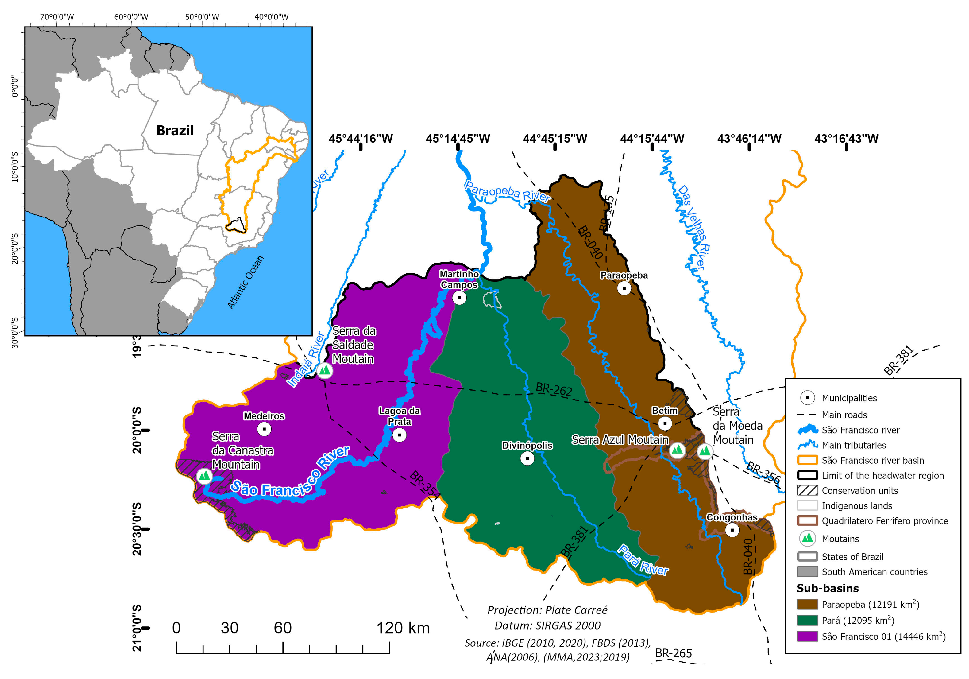
Figure 2.
Steps to create the Environmental Vulnerability Index (EVI).
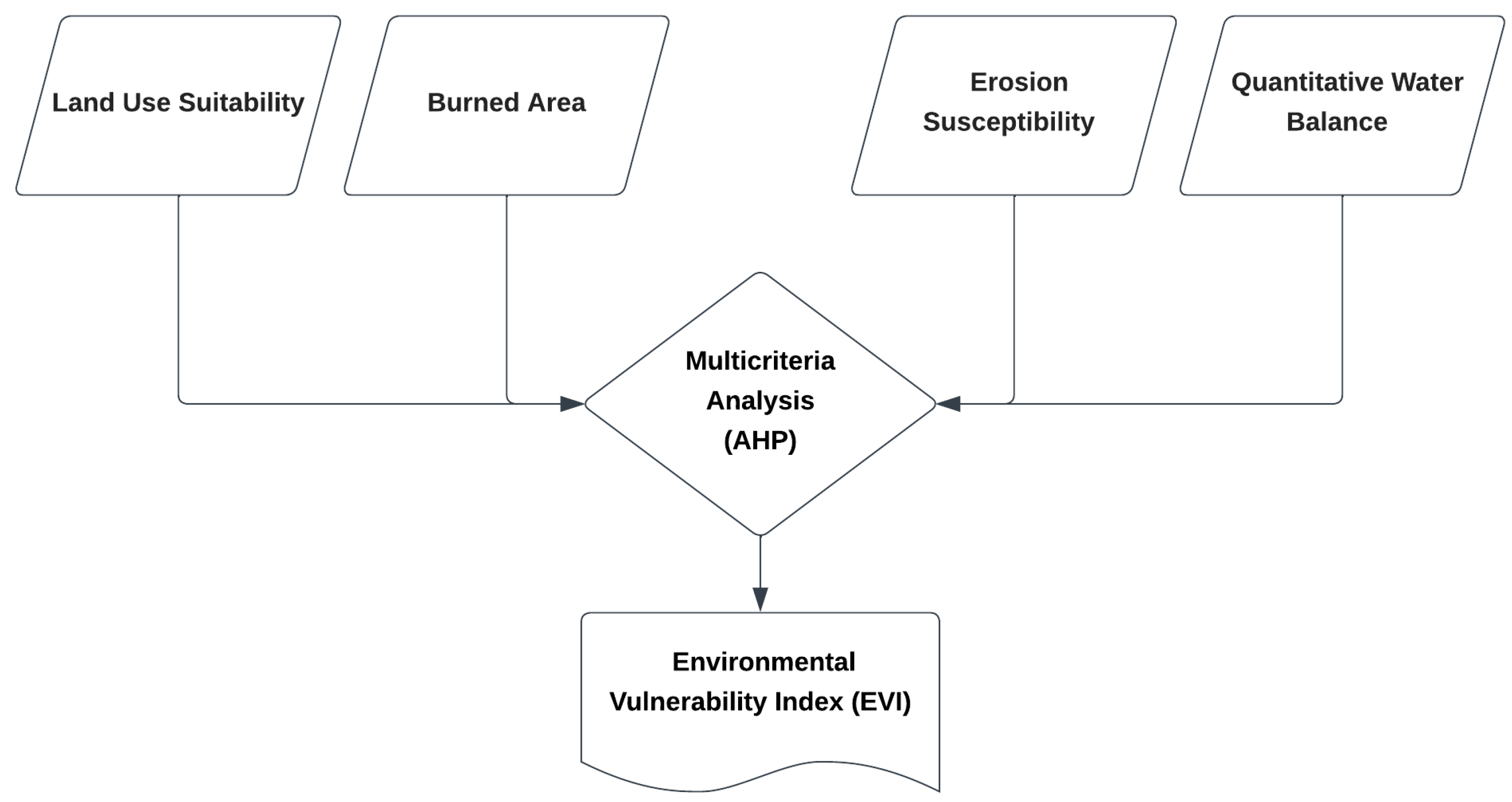
Figure 3.
(a) Land use capability; and (b) Land use intensity in the headwaters of the São Francisco.
Figure 3.
(a) Land use capability; and (b) Land use intensity in the headwaters of the São Francisco.
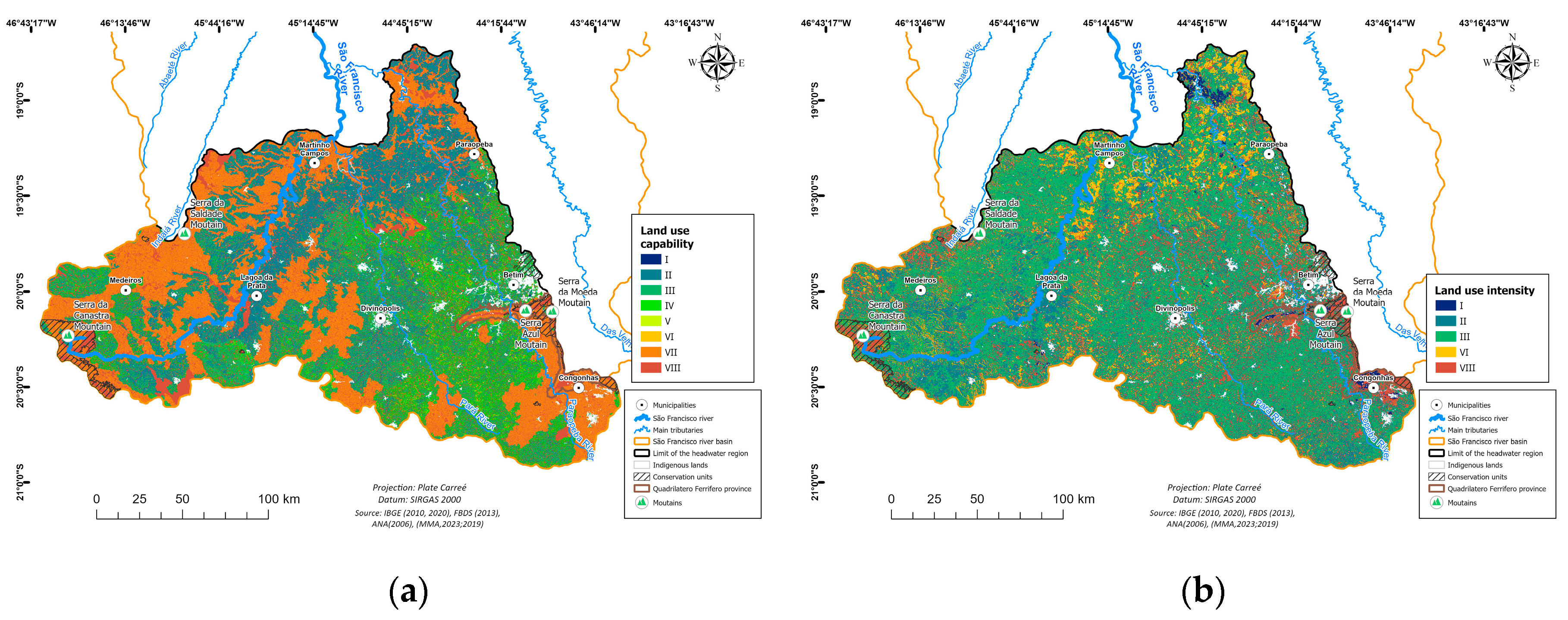
Figure 4.
Number of exceeding classes in the headwaters of the São Francisco River basin.
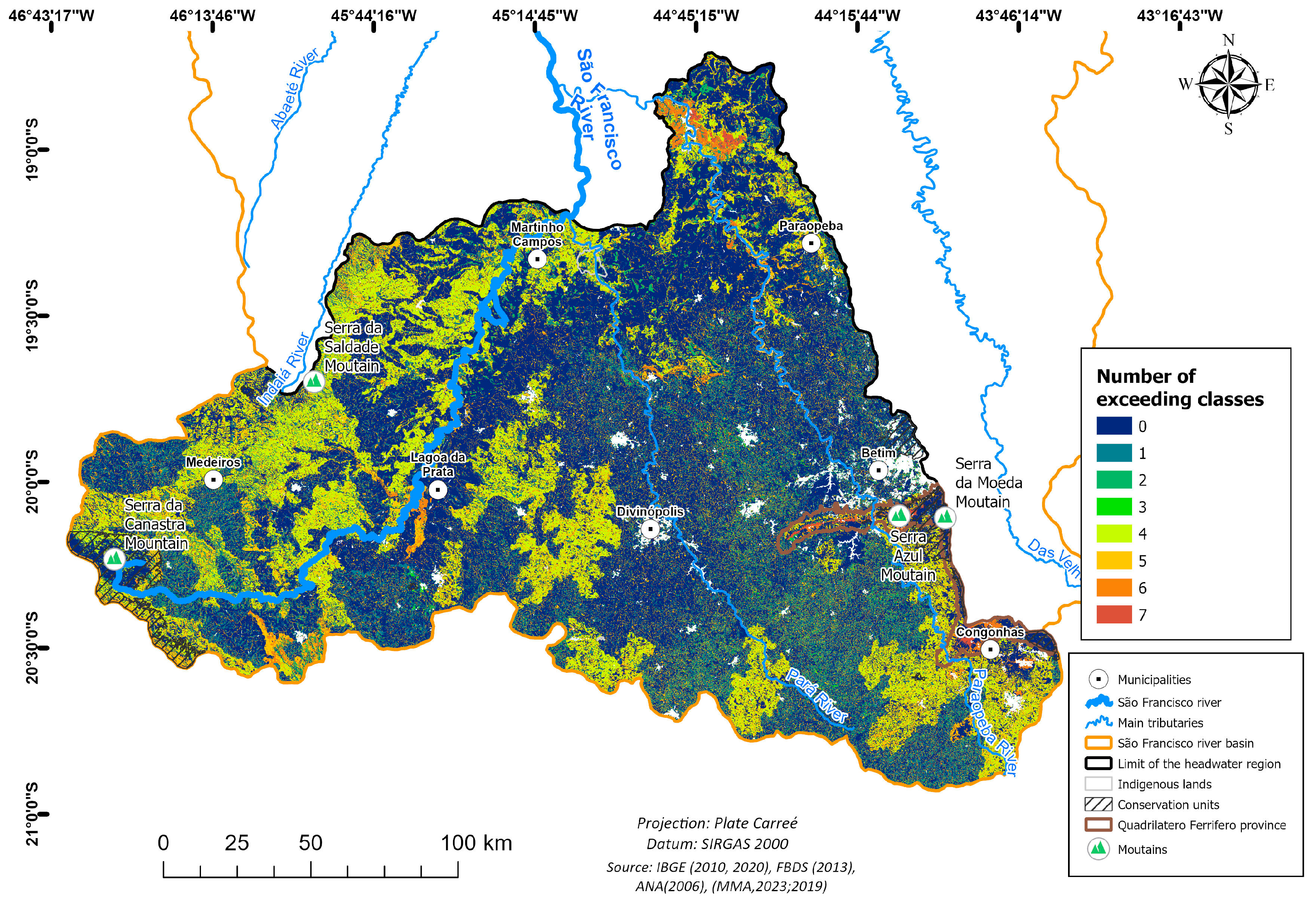
Figure 5.
Recurrence of fires in the headwaters of the São Francisco River basin.
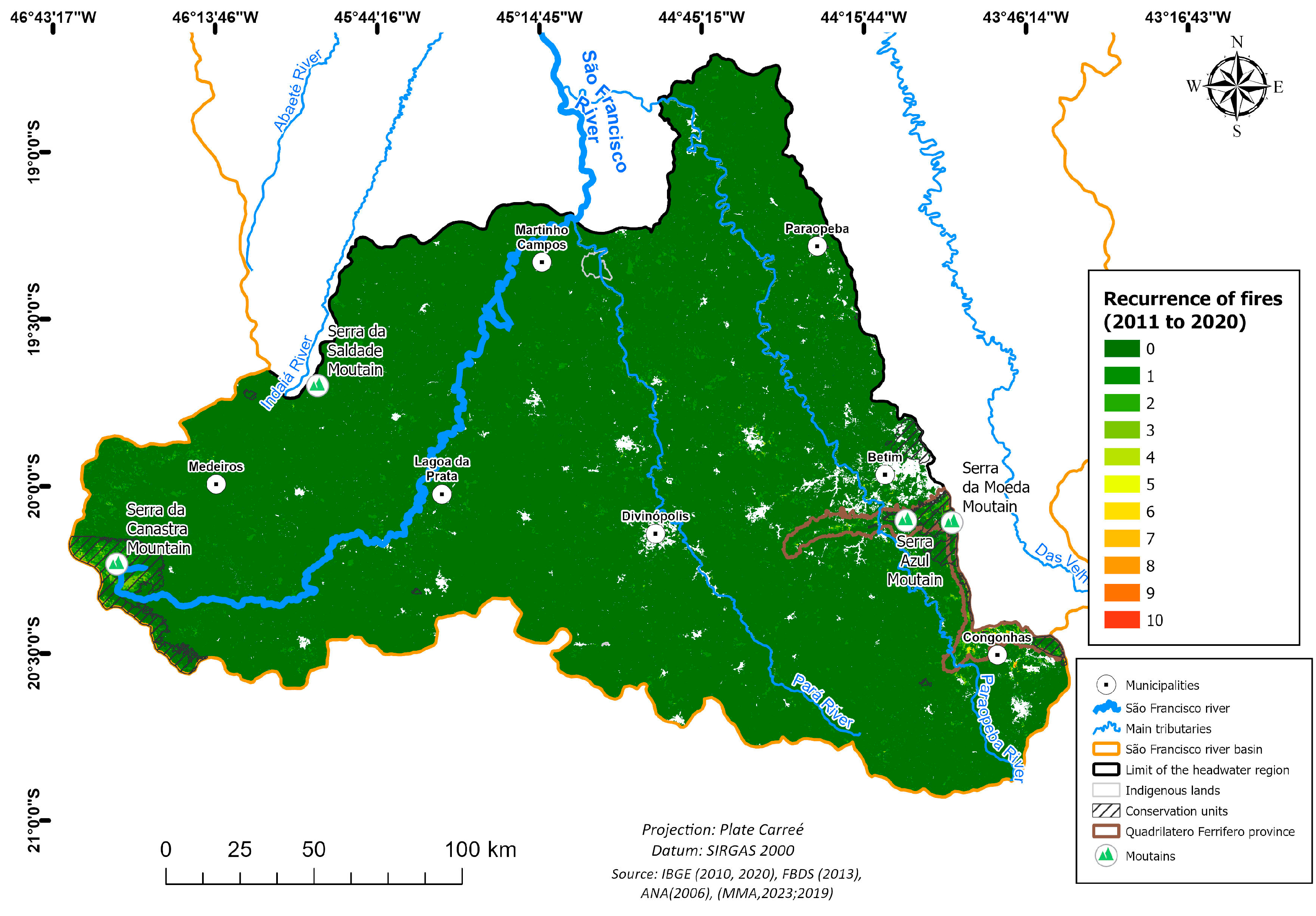
Figure 6.
(a) Rainfall erosivity; (b) Soil erodibility; (c) and Slope at the headwaters of the São Francisco River basin.
Figure 6.
(a) Rainfall erosivity; (b) Soil erodibility; (c) and Slope at the headwaters of the São Francisco River basin.
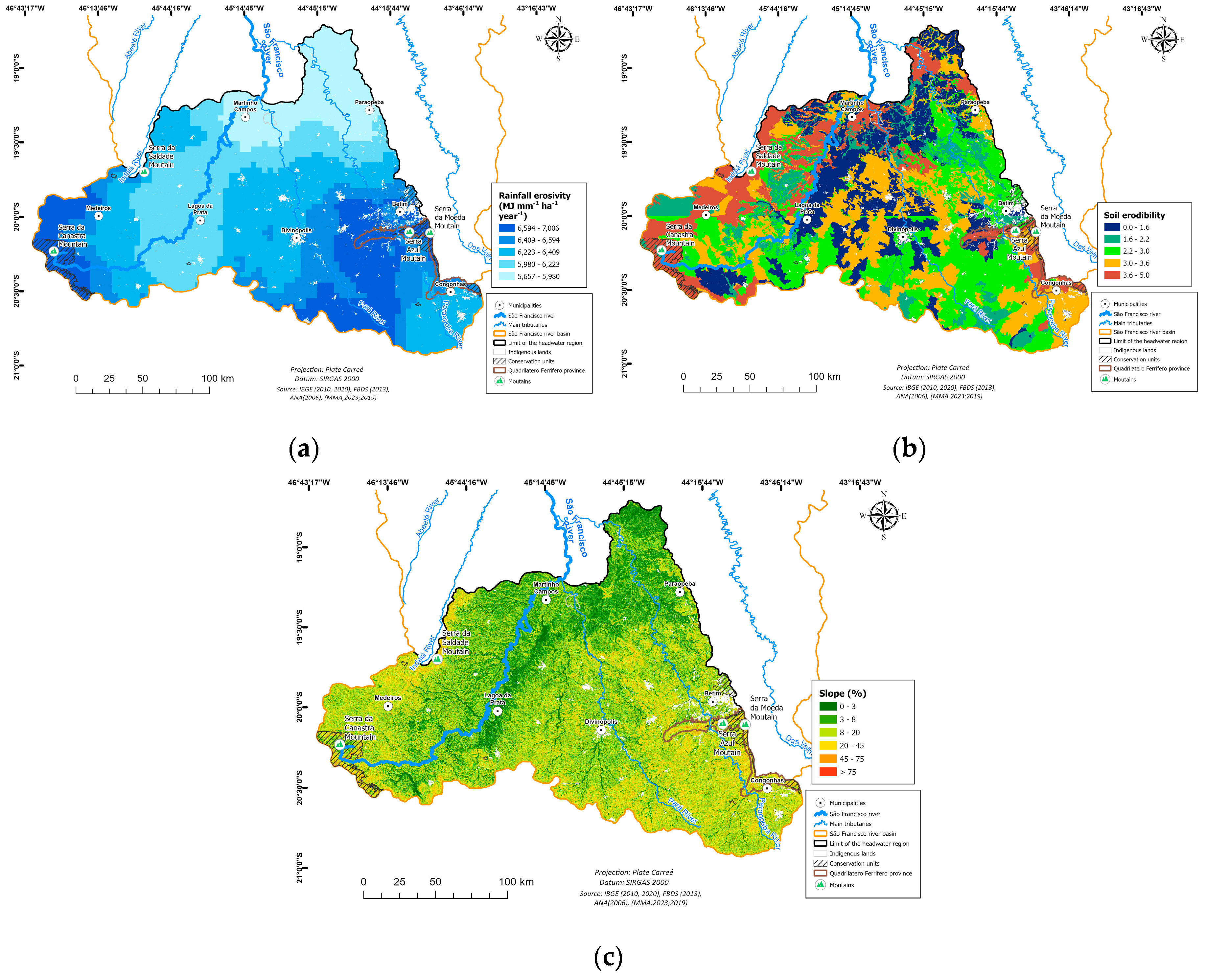
Figure 7.
Erosion susceptibility in the headwaters of the São Francisco River basin.
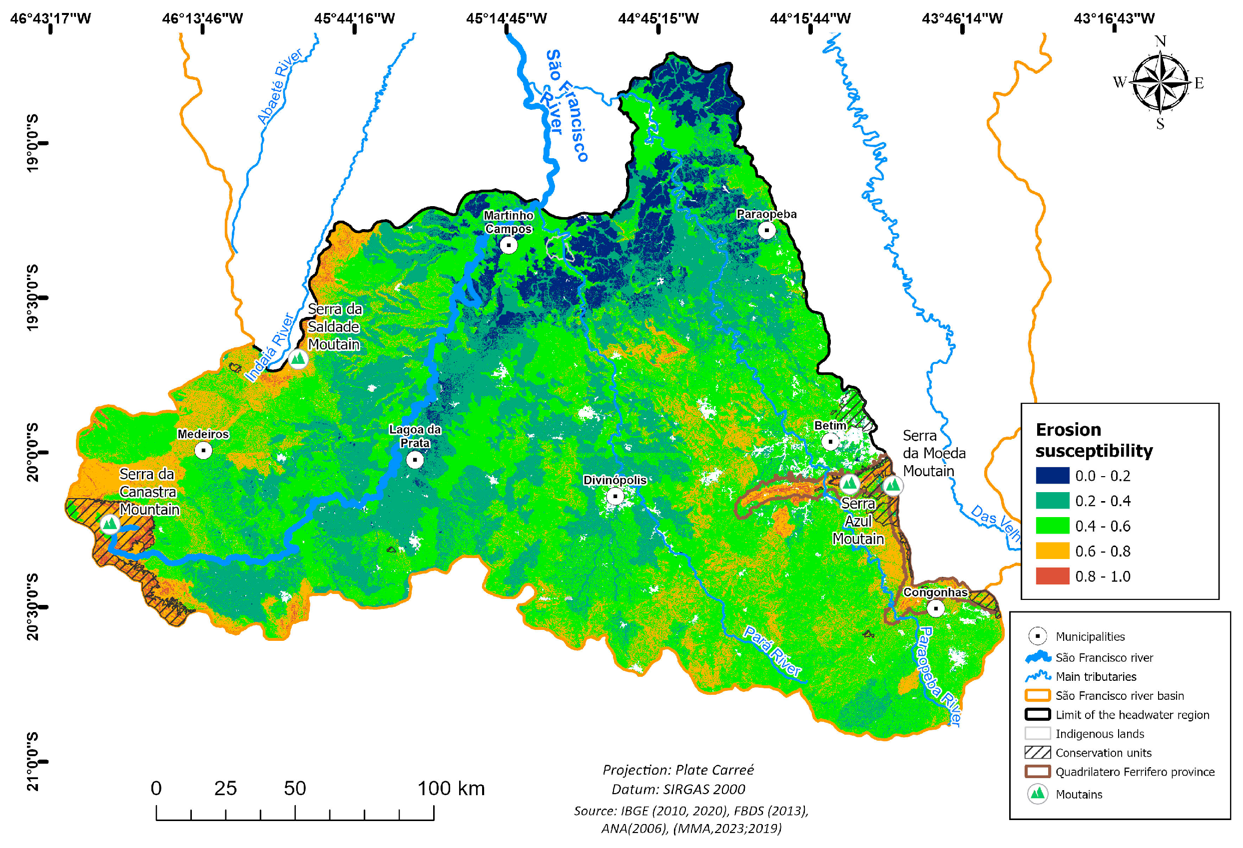
Figure 8.
Quantitative water balance in the headwaters of the São Francisco River basin.
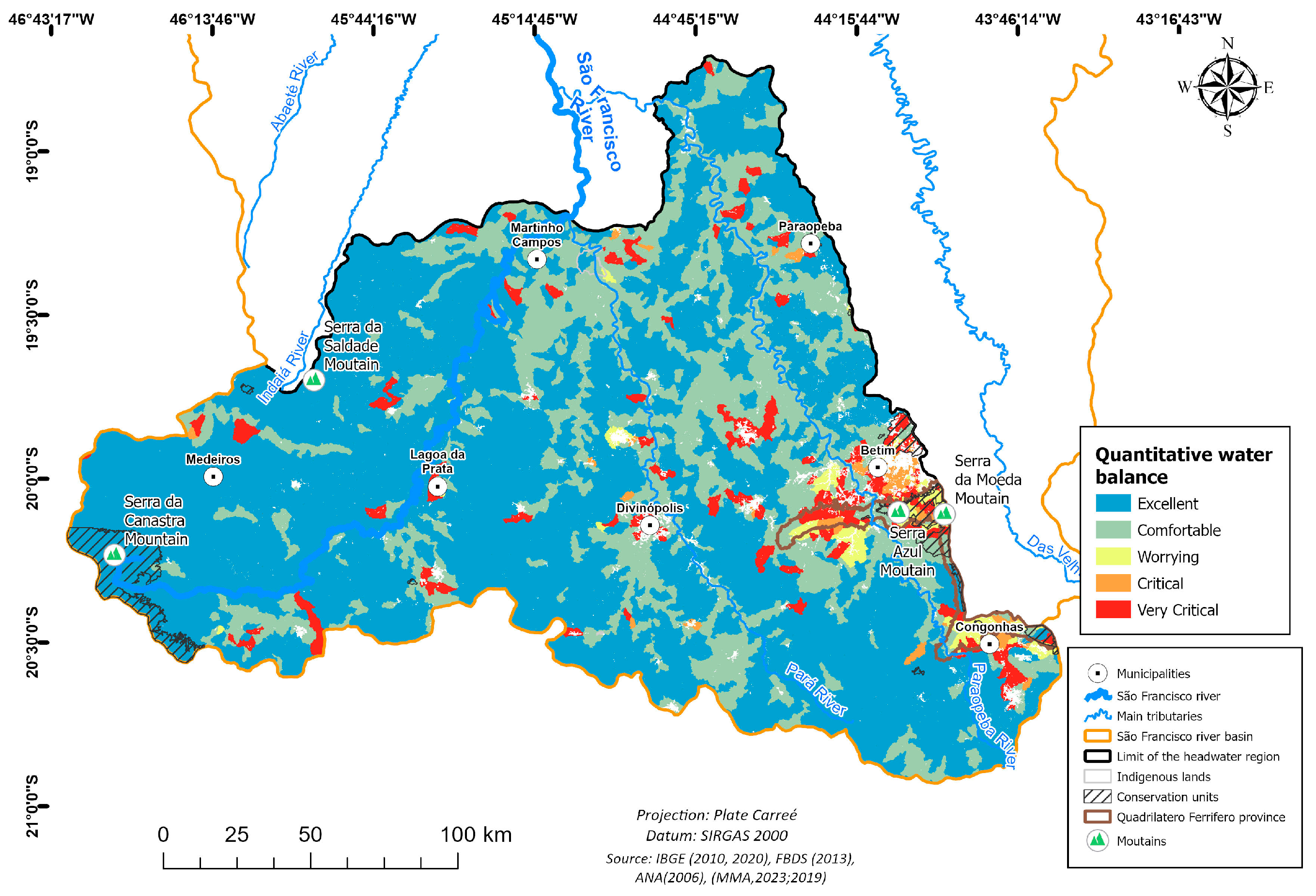
Figure 9.
Environmental Vulnerability Index (EVI) at the headwaters of the São Francisco River basin.
Figure 9.
Environmental Vulnerability Index (EVI) at the headwaters of the São Francisco River basin.
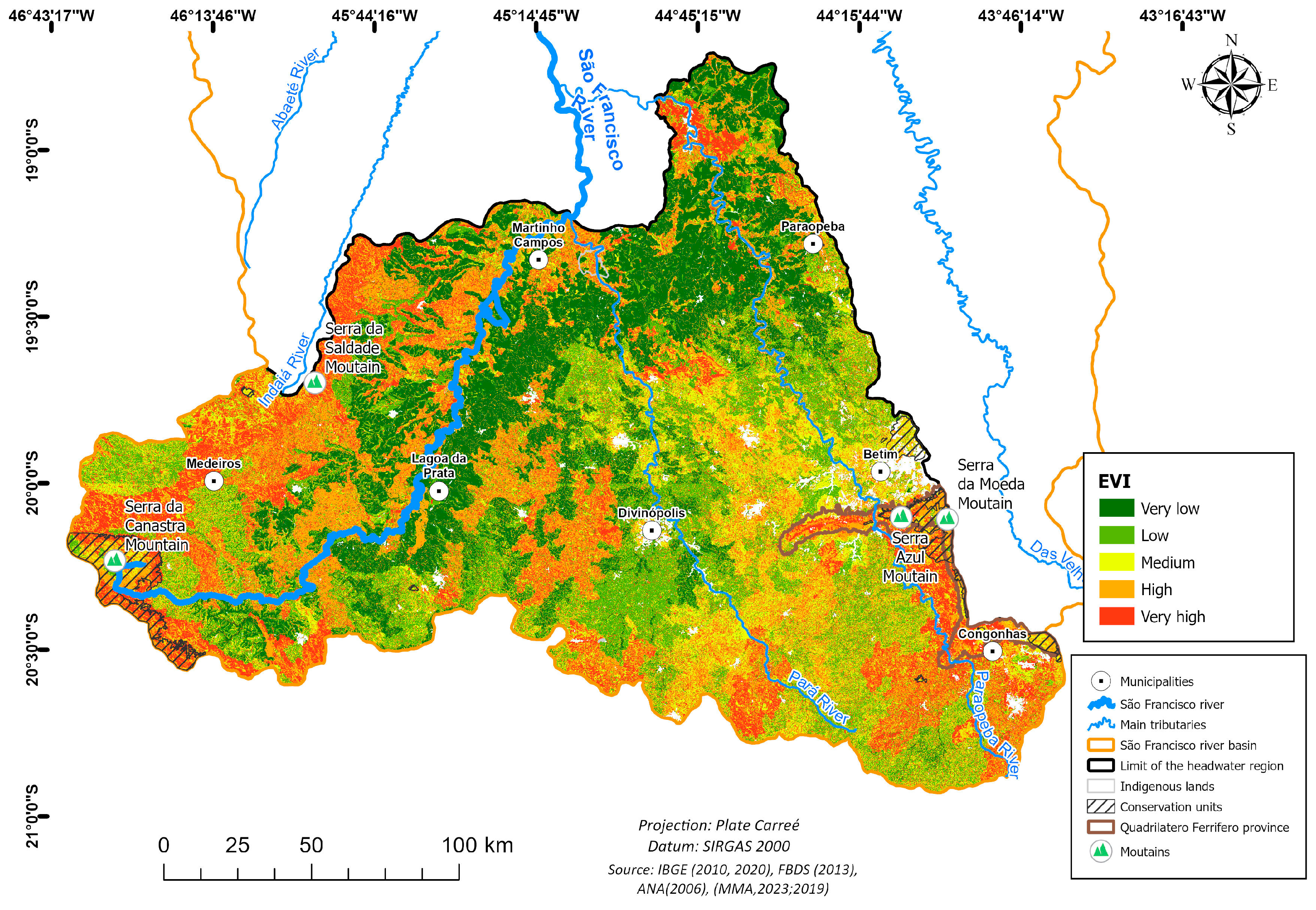

Table 1.
Rating scale of Satty’s analytical hierarchical process and Satty’s ratio index for different N number of variables.
Table 1.
Rating scale of Satty’s analytical hierarchical process and Satty’s ratio index for different N number of variables.
| 1/9 | 1/7 | 1/5 | 1/3 | 1 | 3 | 5 | 7 | 9 | |
|---|---|---|---|---|---|---|---|---|---|
| Extreme | Very strong | Strong | Moderate | Equally | Moderate | Strong | Very strong | Extreme | |
| Less important | Equal | More important | |||||||
| Note: 1/8, 1/6, 1/4, 1/2, 2, 4, 6, 8 can also be used if a greater number of classes exist. | |||||||||
| N | 1 | 2 | 3 | 4 | 5 | 6 | 7 | 8 | 9 |
| RI | 0 | 0 | 0.58 | 0.90 | 1.21 | 1.24 | 1.32 | 1.41 | 1.45 |
Table 2.
Pair-wise comparison matrix and final weight for all variables.
| Criteria | Land Use Adequacy |
Erosion Susceptibility |
Burned Area | Quantitative Water Balance | Weights | CR |
| Land Use Adequacy | 1.00 | 1.00 | 6.00 | 7.00 | 0.429 | 0.09 |
| Erosion Susceptibility | 1.00 | 1.00 | 6.00 | 7.00 | 0.429 | |
| Burned Area | 0.17 | 0.17 | 1.00 | 0.50 | 0.061 | |
| Quantitative Water Balance | 0.14 | 0.14 | 2.00 | 1.00 | 0.08 |
Table 3.
Description of the Land Use Capability Classes (LUC).
| LUC | Description |
|---|---|
| I | Land suitable for all uses, including intensive agriculture without intensive conservation practices |
| II | Land suitable for crops with simple conservation practices |
| III | Land suitable for crops with intensive or complex conservation practices |
| IV | Land suitable for occasional annual crops, limited perennial crops, crops in rotation with pastures, forests, and protection of wild fauna and flora |
| V | Land with little to no risk of erosion, but with limitations impractical to be removed that greatly limit its use. Hence, it is more suitable for pasture, reforestation, or wildlife |
| VI | Land with severe limitations, generally unsuitable for crops, and limited use for pastures, planted forests, or native forests as a refuge for wild flora and fauna |
| VII | Land with very severe limitations, unsuitable for crops, limited use for pastures, planted forests, and refuge of wild flora and fauna |
| VIII | Land with limitations that prevent its use for any agricultural activity, restricting them to recreation and/or protection of wild flora and fauna or even water storage (dams) |
Table 4.
Land use capability classes (LUC) related to soil classes and to slope.
| Soil Class - SiBCS | Soil Class - WRB/FAO | LUC | Slope (%) | LUC |
| Cambissolo Húmico | Cambisol | VII | 0-2 | I |
| Cambissolo Háplico | ||||
| Plintossolo Pétrico | Plinthosols | VII | 2-5 | II |
| Plintossolo Háplico | V | |||
| Gleissolo Melânico | Gleysols | VIII | 5-10 | III |
| Gleissolo Háplico | ||||
| Latossolo Amarelo | Ferralsols | II | 10-20 | IV |
| Latossolo Vermelho Amarelo | ||||
| Latossolo Vermelho | 20-30 | V | ||
| Nitossolo Vermelho | Nitisols | III | ||
| Argissolo Vermelho Amarelo | Acrisols | III | 30-45 | VI |
| Argissolo Vermelho | ||||
| Neossolo Litólico | Leptsols | VIII | 45-70 | VII |
| Neossolo Quartzarênico | Arenosols | V | ||
| Neossolo Flúvico | Fluvisols | I | >70 | VIII |
| Luvissolo Crômico | Luvisols | III |
Note. Adapted from: [21].
Table 5.
Current land use intensity classes (LUI).
| Land Use and Land Cover | LUI |
| Forest Formation | VIII |
| Savannah Formation | VI |
| Silviculture | VI |
| Other Non- Forest Formations | VIII |
| Flooded Field and Swampy Area | VIII |
| Grasslands | VIII |
| Pastures | III |
| Agriculture | II |
| Mosaic of Uses | II |
| Urbanized Area | I |
| Other Non-Vegetated Areas | I |
| Mining | I |
| Rocky Outcrop | VIII |
| Water Body | VIII |
Disclaimer/Publisher’s Note: The statements, opinions and data contained in all publications are solely those of the individual author(s) and contributor(s) and not of MDPI and/or the editor(s). MDPI and/or the editor(s) disclaim responsibility for any injury to people or property resulting from any ideas, methods, instructions or products referred to in the content. |
© 2024 by the authors. Licensee MDPI, Basel, Switzerland. This article is an open access article distributed under the terms and conditions of the Creative Commons Attribution (CC BY) license (http://creativecommons.org/licenses/by/4.0/).
Copyright: This open access article is published under a Creative Commons CC BY 4.0 license, which permit the free download, distribution, and reuse, provided that the author and preprint are cited in any reuse.


