
Submitted:
20 July 2024
Posted:
22 July 2024
You are already at the latest version
Abstract
This study evaluates and contrasts the changes in vegetation cover over three decades in two forest areas in northern Mexico with different management statuses: one with sustainable forest exploitation and the other under protection as a Flora and Fauna Protection Area (FFPA). The hypothesis proposed that both areas would maintain or increase their vegetation cover since 1995. Using QGIS 3.32 “Lima” software and supervised and unsupervised classification methods, satellite images from the periods 1995-2008, 2008-2014, 2014-2021, and 1995-2022 were analyzed. The results showed that the Ejido El Largo y Anexos significantly increased forest areas and reduced grasslands due to sustainable management practices, with notable expansion of pine-oak and pine forests. In contrast, the Tutuaca Flora and Fauna Protection Area (FFPA) showed a notable loss of oak and oak-pine forests, suggesting ineffectiveness in its conservation policies. However, a lesser loss of Douglas fir forest was observed, indicating some effective protection efforts. The comparison reveals opposing dynamics: while Ejido El Largo y Anexos demonstrates success in sustainable management, the Tutuaca FFPA faces conservation challenges. In conclusion, this study highlights the need for active management approaches to maintain ecosystem cover and functionality.
Keywords:
Sustainable forest exploitation
; Flora and Fauna Protection Area
; Vegetation cover
; Multitemporal analysis
; QGIS.
1. Introduction
Forest loss is one of the main environmental issues threatening livelihoods worldwide [1]. Anthropogenic influence stands out as a primary cause of vegetation cover degradation [2], leading to deforestation, agricultural intensification, and urban expansion [3], resulting in significant changes in forest area, carbon sequestration, biodiversity loss, and ecosystem services decline [4].
Although global deforestation rates have decreased over the past decade, many localities and nations continue to experience increasing rates [1]. According to FAO (2020) [5], 420 million hectares of forest have been lost globally since 1990 due to land use change, with a deforestation rate of 10 million hectares per year between 2015 and 2020. In Mexico, original vegetation has drastically decreased, primarily due to conversion of forested lands to agricultural and livestock uses [6].
One response to forest area degradation is establishing conservation sites or protected natural areas. In this regard, Wrońska-Pilarek et al. (2023) and Nascibem et al. (2023) [7,8] suggest that integrating forest lands into conservation statuses increases woody species coverage and diversity, leading to reduced deforestation and increased carbon reservoirs. Various studies document how restoration actions and monitoring in conservation areas maintain or increase vegetation cover [9,10].
On the other hand, sustainable forest management ensures perpetual and optimal production of diverse goods and services from forest ecosystems [11]. Kucsicsa et al. (2020) [12] indicate that forest exploitation in Europe has facilitated forest species establishment and increased forest cover in previously bare areas. Moreover, Kouba et al. (2012) [13] highlight that long-term forest sustainability heavily depends on landscape conservation, as cover changes are driven by plantation introductions. Additionally, numerous studies have proposed using remote sensing data [14,15,16] and satellite image time series [17,18] to estimate forest productivity and cover dynamics.
Remote sensing and GIS techniques are widely used in the scientific community to quantitatively and qualitatively monitor and assess forest ecosystems [19,20], analyzing the spatiotemporal evolution of forested areas based on various satellite image ranges [21,22,23]. According to Hernández-Cavazos et al. (2023) [24], research evaluating land use and vegetation changes to quantify annual deforestation rates using GIS and remote sensing tools has increased in Mexico. However, the multitemporal dynamics of forest cover in managed and conservation-designated forests in the state of Chihuahua have not been previously evaluated. In this sense, understanding and quantifying multitemporal forest cover dynamics are crucial for revealing the interaction mechanisms between human activities and the natural environment [27,28,29].
In this study we analyzed the cover changes in the Ejido El Largo y Anexos, an agrarian nucleus with forest management in natural forests since the early 20th century [25], and to identify the multitemporal dynamics of vegetation cover in the Flora and Fauna Protection Area "Tutuaca," designated in 1937 [26]. We aimed to evaluate and contrast the changes in vegetation cover over the last three decades in two forest areas with different management statuses: one with sustainable forest exploitation and the other designated for conservation. The hypothesis posits that both areas will maintain or increase vegetation cover since 1995.
2. Materials and Methods
2.1. Study Area
The study area is located in the western part of the state of Chihuahua, Mexico, and encompasses two zones: Ejido El Largo y Anexos, situated between 28°44'55''N, 29°57'10''N and 108°05'50''W, 108°42'10''W, and the Natural Protected Area (NPA) Tutuaca, designated as a Flora and Fauna Protection Area (FFPA), located between 28°08'40''N, 28°44'50''N and 107°29'40''W, 108°42'05''W (Figure 1). The ejido has a sub-humid temperate climate (C(w1)x') with an average annual temperature between 12°C and 18°C, eutric cambisol soils, an average annual precipitation of 616.5 mm, and elevations ranging from 1093 to 2822 m [30]. The ANP Tutuaca exhibits four types of climates across its extension, predominantly a semi-warm sub-humid climate ((A)C(wo)), with an average annual temperature above 18°C, haplic phaeozem soils, an average annual precipitation of 775.5 mm, and altitudes varying from 783 to 2764 m [30].
2.2. Image Acquisition
The orthophotos were obtained from the Espacios y Datos de México platform through the website https://www.inegi.org.mx/temas/imagenes/ortoimagenes/#Descargas, and the high-resolution satellite images from Airbus Defence and Space, GeoEye-1, and Birdseye were obtained using SASPlanet software through the website http://www.sasgis.org/download/. Both tools are open-source and allow for free visualization and download of images. Four orthomosaics were generated, composed of 123 orthophotos with a resolution of 1.5 m/pixel (year 1995), 625 images from Airbus Defence and Space with a resolution of 1.14 m/pixel (year 2008), and 2,632 images from GeoEye-1 and Birdseye with a resolution of 0.28 m/pixel (years 2014 and 2022). The procedure used is shown in Figure 2.
2.3. Digitization of Images
Land use and vegetation were analyzed through an unsupervised classification using the "K-Means Cluster Analysis" (KMC) module. Subsequently, a supervised classification was performed using training sites from field data, executing a total of 10 automated classifications, which were summarized into eight classes of land use and vegetation with the "Iterative Minimum Distance" multivariate data cluster analysis method [31]. All procedures were conducted using the QGIS 3.32 “Lima” software [32], which integrates the open-source System for Automated Geoscientific Analyses (SAGA) process toolbox under a General Public License. Information was generated for the following ecosystems: Douglas Fir forest, oak forest, oak-pine forest, pine forest, pine-oak forest, juniper forest, grassland, low deciduous forest, and areas devoid of vegetation [33]. This information was validated against historical land use data for the study area and field surveys.
2.4. Multitemporal Analysis
To calculate changes (increase or loss) in vegetation cover and land use, a cross-tabulation was generated for five different time periods: 1995-2008, 2008-2014, 2014-2021, and 1995-2022. The net change, rate of change, and relative percentage change were calculated for each type of vegetation cover or land use over time.
2.5. Determination of Losses and Gains in Coverage
The determination of loss or gain in coverage for different land uses and vegetation types was achieved by constructing four transition matrices and one change rate matrix for the periods. To determine the rate of change, the equation adapted by [34] was used.
where: = Rate of change expressed as a percentage; = Area at date 1; = Area at date 2; and = Number of years between the two dates.
Net change was obtained from the difference in forest area between two points in time. When the net change result is positive, it indicates a general gain in forest area, and when it is negative, it indicates a general loss of forest area [5].
For the calculation of the relative percentage change (∆A %), the following equation was used [35]:
where: ∆A % = Relative percentage change; At2A = Vegetation cover or land use at the final time; and, At1: Vegetation cover or land use at the initial time.
2.6. Annual Deforestation Rate
Changes in land cover were identified by comparing two sets of vegetation and land use maps, creating new maps that indicated the transitions between the study years. Using the data obtained from image processing, the annual deforestation rate was calculated, which involves comparing the land cover at the same site during two different time periods. This calculation utilized the equation proposed by [36]:
where: r = Vegetation cover; A1 = Vegetation cover or land use at the initial time; A2 = Vegetation cover or l and use at the final time; t1 = Initial period; and, t2 = Final period. A positive value of "r" indicates an increase in vegetation cover, while a negative value demonstrates a loss of coverage.
3. Results
Maps representing land cover in the Ejido El Largo y Anexos and the Tutuaca Protected Natural Area, both located in the state of Chihuahua, were generated for the years 1995, 2008, 2014, and 2022. These maps served as a baseline data for conducting a detailed analysis of the changes that occurred over this period (Figure 3). The image classification yielded average Kappa index values of 0.79, indicating a substantial level of accuracy in the process. It's worth noting that the Kappa index is a recognized indicator of image classification reliability, and a value of 0.79 is considered significant in terms of the precision achieved. This result suggests that the classification of land cover on the maps is consistent and reliable for supporting the analysis of changes over time.
The comparison of results between Ejido El Largo y Anexos and the Tutuaca Protected Natural Area (PNA) reveals divergent trends in the coverage of different ecosystems, highlighting both similarities and differences in land use changes and forest conservation. In Ejido El Largo y Anexos, there is a general trend of increasing forest and grassland areas. Among the main ecosystems, those showing the greatest recovery by 2022 were oak forest, which regained 9,470.64 hectares (29%) of its 1995 coverage, followed by pine-oak forest with a recovery of 8,976.09 hectares (10.06%), and the Pine forest, which regained 9,044.57 hectares (8.98%).
This trend suggests a significant contribution from silvicultural treatments and sustainable ecosystem management. Activities within the ejido boundaries have effectively suppressed agricultural expansion, livestock grazing, urbanization, and forest degradation. Moreover, comprehensive restoration activities, continuous reforestation, and sustainable forest cultivation have reduced areas devoid of tree vegetation significantly. In contrast, the Tutuaca PNA shows a notable decrease in the coverage of certain forests, particularly the oak forest, which lost 50,627.88 hectares by 2022, representing an increase of 36.92% from its 1995 loss. This is followed by the oak-pine forest with a loss of 33,671.92 hectares (24.42%) and the pine forest with a decrease of 13,674.47 hectares (20.04%).
This reduction in coverage indicates possible degradation or inefficient conservation efforts within the protected area. However, the Douglas Fir forest exhibited a drastic expansion, reducing its annual loss from 242.17 hectares (0.27%) in 1995 to just 9.80 hectares in 2022 (0.00%), reflecting significant mitigation of degradation in this type of forest.
Comparing both territories highlights two contrasting dynamics: while Ejido El Largo y Anexos showed a trend of recovery in forest and grassland areas, the Tutuaca PNA exhibited a notable decrease in certain forests, especially oak. The increase in pine forest and grasslands in Ejido El Largo y Anexos suggests effective forest management and a decrease in overgrazing activities. On the other hand, the decrease in oak forest in Tutuaca suggests relative failure in conservation efforts within the protected area. However, the significant mitigation of Douglas Fir forest reduction in Tutuaca indicates successful protection activities in this specific ecosystem (Table 1).
In Ejido El Largo and Anexos, the implementation of silvicultural treatments, continuous reforestation, and sustainable management practices have proven effective. Active community participation in forest conservation and restoration has been crucial in achieving these positive results. In contrast, despite focusing conservation efforts, the decrease in vegetation cover in Tutuaca suggests that implemented strategies have not been sufficient to halt ecosystem degradation, especially in Oak forests.
Furthermore, the reduction in areas devoid of vegetation in Ejido El Largo y Anexos suggests effective control over agricultural, livestock, and urban expansion, allowing for the recovery of natural ecosystems. Conversely, in Tutuaca ANP, the decline in forests could be related to increased anthropogenic pressures such as illegal logging, unsustainable agriculture, and other environmental factors that have not been adequately predicted or mitigated.
Continued efforts in restoration and reforestation in Ejido El Largo y Anexos have resulted in sustained recovery of forest cover, demonstrating a strong commitment to ecosystem conservation. In Tutuaca PNA, by the contrast, the lack of effective reforestation and significant loss of forests like Douglas Fir indicate a need to review and strengthen conservation strategies. Additionally, the degradation of unmanaged forests (Tutuaca PNA) can lead to reduced provision of ecosystem services and decreased health and productivity, impacting both nature and human well-being. Similarly, unmanaged forests are less resilient to climate change, including droughts, pest outbreaks, and wildfires.
Figure 4 illustrates the evolution of vegetation cover in Ejido El Largo y Anexos and the Tutuaca Protected Natural Area (PNA) during the years 1995-2022. It shows a notable increase in grassland extent and a loss in oak forests and oak-pine mixed forests, especially in the Tutuaca ANP. In 1995, Ejido El Largo y Anexos were predominantly covered by pine and pine-oak forests, with a significant presence of temperate ecosystems. By 2008, oak and oak-pine forests had expanded their relative extent, reducing grasslands. This trend intensified by 2014, with a higher proportion of mixed forests and fewer grasslands. Finally, by 2022, there was a confirmed decrease in grassland areas and a clear predominance of pine and pine-oak forests. These changes reflect a significant transformation in land use and ecological dynamics in both regions. In this context, sustainable and adaptive forestry has proven to be an essential component in increasing tree cover in Ejido El Largo y Anexos. Additionally, restoration practices, including natural and assisted regeneration, promote the expansion of tree cover and the reduction of grasslands.
During the study period from 1995 to 2022, significant changes were observed in the rates of change of different ecosystem types in Ejido El Largo y Anexos, as well as in the Tutuaca Protected Natural Area (PNA). In Ejido El Largo y Anexos, there was a notable increase in oak forest area, with a relative change rate of -45.96%, indicating a deceleration in the loss of these ecosystems and an increase in their coverage. However, oak-pine and pine-oak mixed forests showed decreases of -19.63% and -21.38%, respectively, suggesting efforts to slow down their loss and increase their coverage have been effective.
In contrast, the Tutuaca PNA experienced significant decreases in oak (223.12%) and pine (161.79%) forest areas, indicating possible changes in management and conservation of these ecosystems, resulting in accelerated and sustained loss. On the other hand, Douglas Fir forests showed a significant reduction in coverage loss, with a relative change rate indicating an increase in forest cover within the PNA, as shown in Figure 5. These results underscore the importance of actively monitoring and managing forest resources to maintain biodiversity and ecosystem functionality in the face of environmental and anthropogenic pressures. Additionally, it highlights that sustainably managed and adaptively managed forests, as seen in Ejido El Largo y Anexos, tend to increase vegetation cover.
Figure 6 shows that in Ejido El Largo y Anexos, a decrease in deforestation is observed, primarily marked in oak and grassland ecosystems, with deforestation rates of -2.93% and -3.69% respectively, followed by minor decreases in pine forests. In Tutuaca, significant forestation is highlighted in Douglas Fir forests (-12.38%) and pine-oak forests (-4.68%), while oak and pine forests showed significant loss of coverage, with deforestation rates of 4.81% and 3.96% respectively.
The analysis reveals significant patterns in deforestation rates. In Ejido El Largo y Anexos, pine forests showed a considerable decrease in deforestation rates in 2022, with marked reduction observed from 2014 to 2022. Pine-oak forests, on the other hand, exhibited the lowest deforestation related to tree cover loss, particularly in 2022, reflecting changes in management practices or environmental conditions. There was also a notable decrease in deforestation rates in grasslands, primarily reduced in 2014 and 2022.
In contrast, in Tutuaca National Park (PNA), there was notable mitigation in the loss of Juniper and Douglas Fir forests, reducing impacts up to -9.03% in 2014 for the former and up to -22.00% in 2022 for the latter. However, there was a steady decline in oak coverage, with a significant rate in 2014 and 2022, a similar trend observed in pine and pine-oak forests during the same period. Lastly, the dry tropical forest showed the highest deforestation rate, with a decrease in coverage from 2014 to 2022, though with fluctuations in intermediate periods (Figure 7).
In Ejido El Largo y Anexos, there has been a significant increase in the total area of various types of forest ecosystems. In contrast, Tutuaca National Park (PNA) has experienced a loss in the covered area of several types of forest ecosystems. This comparison suggests that while Ejido El Largo y Anexos have achieved notable reductions in deforestation rates, PNA Tutuaca has seen a decrease in its forested area, likely due to conservation policies that restrict forest management and may lead to illegal logging, unsustainable agricultural practices, degradation of vegetation cover, and an increase in the agricultural gap
4. Discussion
The classification of images in this study presented average Kappa index values of 0.79, according to Brennan and Prediger (1981) [37]. Cohen interpreted this Kappa value as the proportion of agreement among raters after accounting for chance agreement, indicating that a higher Kappa value implies greater agreement. However, several studies mention that the Kappa index has increasingly faced criticism due to its sensitivity to asymmetric distributions and inherent uncertainty [38,39,40,41]. Nevertheless, other authors suggest that Kappa values greater than 0.75 are considered highly accurate [9,24,42,43,44]. Therefore, despite criticisms regarding Kappa's sensitivity, the value obtained in this study suggests high agreement and, consequently, reliable analysis of changes in vegetation cover. Interpretation of this result should consider both limitations highlighted by some studies and support from others validating Kappa's use as a robust indicator of agreement and accuracy in complex classifications.
The comparison of results between Ejido El Largo y Anexos and Tutuaca National Park reveals divergent trends in the coverage of different ecosystems, highlighting both similarities and differences in land use changes and forest conservation. In Ejido El Largo, there is a notable expansion of ecosystems, where the pine-oak forest, which was the largest in 1995 covering 31.71% of the area, increased to 33.39% by 2022. The pine forest decreased in relative area from 28.46% in 1995 to 28.62% in 2022; however, the absolute area trended upwards. On the other hand, Tutuaca National Park shows a significant decrease in the coverage of certain forests, particularly oak forests. In 1995, the oak-pine forest had a relative coverage of 32.49% of the area, which grew to 36.75% by 2008, continuing this trend to reach 35.93% by 2022. However, the ecosystems show a significant decrease in their extent, reflecting loss of ecosystems and an increase in vegetation-free areas.
Other studies conducted in various geographic regions have focused on measuring land use change, where results similar to those described in this study have been identified. Cases such as the study of the Qena-Luxor governorates in Egypt, covering the period from 1984 to 2018, found that agricultural lands grew from an average of 123,870 ha (9.8%) in 1984 to 170,704 ha (13.40%) in 2018, and urban lands increased from 34,520 ha (2.7%) in 1984 to 44,528 ha (3.5%) in 2019. Moreover, lands recovering vegetation increased from approximately 437,970 ha in 1984 (34.4% of the total study area) to 452,105 ha in 2000 (35.50%); however, this classification was followed by a marked decrease to 437,351 ha (34.35%) between 2000 and 2010 and then increased to approximately 444,200 ha (34.89%) between 2010 and 2018. On the other hand, desert lands (limestone plateau and some lowland desert strips) decreased from 663,540 ha (52.2%) to 600,350 ha (47.15%) [45]. These studies reflect complex dynamics in land use change, where factors such as agricultural growth, urbanization, and vegetation recovery play crucial roles in different geographic contexts. The expansion of forests in Ejido El Largo and the loss of vegetation cover in Tutuaca National Park are comparable to the changes observed in agricultural and desert lands in Egypt.
Vivekananda et al. (2021) [46] identified land use changes from 1978 to 2018 in the Ananthapur district of Andhra Pradesh state in southern India. They found a marked spatial expansion of urban areas. In 1978, the area occupied by urbanized land was minimal (681 ha) and primarily located in the center of the study area, increasing to 3,775 ha by 2018. Categories such as water bodies, forests, and agricultural lands exhibited a decrease in area, -73.04%, -31.00%, and -61.84%, respectively, while built-up lands and vegetation-free lands exhibited an increase in area, 454.33% and 104.70%, respectively. This study reflects a global trend in land use change, where urbanization and expansion of built-up areas are common, often at the expense of natural and agricultural areas; however, such a situation has not occurred in the study cases, since they are rural regions, where anthropogenic isolation leads to migration trends.
In a study conducted for the period 1999 to 2014 in the Ribeirão do Meio watershed in Brazil, a direct relationship was found between changes in land use, land cover, and verified environmental fragility classification. Land use in the watershed changed significantly, with sugarcane cultivation expanding notably from 20.11% to 58.96% of the total area. This growth was accompanied by a significant reduction in exposed soil, decreasing from 47.50% to 15.82%, and a decrease in permanent crops from 13.44% to 2.40%. Urbanization and rural settlements also increased, though to a lesser extent, while forest area slightly increased. Additionally, both mining and fish farming experienced small increases, while water resources marginally decreased from 0.38% to 0.36% [47].
The findings of the PNA Tutuaca differ from those reported by Rosero et al. (2023) [10], who estimated spatiotemporal changes in landscape and fragmentation levels in the Llanganates National Park (PNL), a protected area in the Andean center of Ecuador. They recorded no significant difference in land cover change between 1991 and 2016 and found fragmentation levels to be low. Changes in land cover in the study area are not evident, as it is a protected area where ecosystems are generally expected to maintain their initial conditions over time. They concluded that biodiversity conservation and landscape processes in the PNL are effective.
Furthermore, the findings of the PNA Tutuaca differ from those obtained by [9], who conducted a multi-temporal analysis of the Cumbres de Monterrey National Park, Mexico, spanning from 2002 to 2018. The results indicate a gradual recovery of forest cover, mainly in pine, pine-oak, oak-pine, oak, and Douglas Fir forests, in response to resilience capacity and prioritization of ecological restoration strategies in these ecosystems.
The data obtained for the PNA Tutuaca are comparable to those achieved by [48], who studied land use change between 1984 and 2015 in the Metchie-Ngoum Forest Reserve in Cameroon. Their results indicated that 36.11% of forest cover suffered degradation resulting in secondary forest cover, which also experienced cumulative loss in area. They mention that forest loss is related to oil palm expansion, population growth, urbanized areas, and settlement-related activities such as illegal logging.
In the Cortadera Regional Natural Park in Colombia, between 1986 and 2016, [49] evaluated agricultural frontier and multi-temporality of vegetation cover. The results of this study are similar to those obtained in the PNA Tutuaca. A continuous decrease in dense non-woody grasslands of firm ground over time was identified (from 3,604 ha in 1986 to 2,531 ha in 2016). In contrast, the mosaic cover of grasslands and crops increased by 1,447 ha over 30 years (from 1,231 ha in 1986 to 2,678 ha in 2016). It is concluded that changes in the distribution of vegetation cover types occur due to agricultural frontier expansion, despite the declaration of the protected area.
Gallardo-Cruz et al. (2021) [50] mention that the effectiveness of a Protected Natural Areas system largely depends on the social matrix in which it occurs. [48] mention that forest cover loss is basically due to increased settled population and areas near Protected Natural Areas. Therefore, authors like Miller et al. (2011) [51] indicate that a paradigm shift incorporating new ideas in the conceptualization, design, and management of Protected Natural Areas considering emerging environmental concerns and different socioeconomic contexts is important.
Although general trends in land use change and vegetation cover are similar in various regions, local specificities such as land management policies, environmental conditions, and socioeconomic factors play a crucial role in determining specific outcomes. The expansion of certain forest types in Ejido El Largo contrasts with the decrease in forest cover in ANP Tutuaca, as does the increase in sugarcane cultivation in the Ribeirão do Meio watershed, reflecting region-specific dynamics related to primary sector activities that are relevant and characteristic of each geographical region.
A study conducted between 1996 and 2017 in the Haridwar and Laksar regions of India, Kumar et al. (2020) [52] found that orchard area decreased rapidly by 11,806.65 ha (9.82%) and permanently converted to urban and agricultural use due to urbanization and industrialization in the Haridwar region from 1996 to 2017. Meanwhile, other land use areas, such as urban land, grasslands, and hydrographic basins, increased by 3,022.11 ha (2.51%), 10,088.82 ha (8.39%), and 5,191.47 ha (4.32%), respectively. Terrestrial vegetation and water mass have been decreasing since 1996 by 12,856.41 ha (10.70%) and 802.63 ha (0.66%), respectively, over 21 years. In contrast, Tutuaca, being a Protected Natural Area, applies strict conservation policies limiting urban expansion and promoting preservation of natural ecosystems. On the other hand, as in the case of Ejido El Largo, government subsidy and support programs for conservation and sustainable land management incentivize communities to maintain and expand forest areas instead of developing urbanized land.
In the particular case of Mexico, similar results have been obtained regarding changes in land use for predominantly forested lands. In the state of Michoacán, Mexico, 28.36% of temperate forests were lost over an 18-year period (1975-1993), with a deforestation rate of -1.8% [53]. Similar results were observed in the San Marcos River sub-basin, Puebla, Mexico, where over a 24-year period (1976-2000), 62.65% of cloud forest was eliminated, mainly due to the introduction of crops such as coffee [54]. Meanwhile, in other regions of Mexico such as Michoacán and Puebla, significant forest losses have been recorded due to deforestation caused by agriculture and other land uses. Ejido El Largo has managed to conserve and even expand its natural ecosystems through effective management and restoration strategies. These cases demonstrate the importance of appropriate forest policies, community participation, and integrated territorial planning to mitigate the negative effects of land use change in sensitive areas and promote sustainable development.
Various studies attribute tree cover loss to timber forestry [55,56], multiple pressures from anthropogenic activities [9], urbanization growth [57,58,59], and abandonment of agricultural lands and increase in bare soils [60]. On the other hand, Oliveira-Andreoli et al. (2021) [47] mention that the application of environmental legislation could have a positive effect on land use change scenarios. In contrast to the negative effects observed in other studies, such as tree cover loss due to timber forestry and other anthropogenic activities, Ejido El Largo has implemented sustainable management practices. These practices not only protect the productivity of existing forests but also promote their expansion, as evidenced by the increase in pine and pine-oak forest areas and stabilization of forest cover.
Figueredo-Fernández et al. (2020) [61] indicated that managed pine forests in Guisa, Cuba, showed the greatest vegetation cover recovery. This demonstrates that forest management in that area has been effective, similar to what has been observed in Ejido El Largo. Similarly, in Linares, Nuevo León, Hernández-Cavazos et al. (2023) [24] observed that oak, oak-pine, and pine-oak forests had the lowest coverage in the municipality and experienced a decrease from 1995 to 2021. Additionally, they do not mention any type of timber forestry in these areas. This contrasts with findings in Ejido El Largo, where timber forestry appears to be an important strategy for conserving these types of vegetation.
Finally, worth mentioning that strict environmental regulations in PNA Tutuaca have played a relevant role in the loss of natural areas related to urbanization and other forms of unsustainable development. However, these regulations have not allowed maintaining the ecological integrity of the protected area and preventing tree cover loss, mainly in oak and oak-pine ecosystems. Likewise, strict land conservation leads to an increase in fuels, which leads to the presence of fires, pests, and diseases that decrease tree cover.
5. Conclusions
The hypothesis proposed is partially rejected, since one of the evaluated areas did not maintain or increase vegetative cover. On the one hand, Ejido El Largo y Anexos has experienced a notable increase in the surface area of various types of forests and grasslands over the past three decades. Pine-oak and pine forests have shown significant expansion, while grasslands have significantly reduced, reflecting sustainable management of these arboreal ecosystems, due to adaptive forest use activities and control over agricultural, livestock, and urban activities.
On the other hand, the Tutuaca National Protected Area (PNA) has shown a significant loss in oak and oak-pine forest cover. This decrease suggests that conservation and management policies implemented in the protected area have not been effective. However, the reduced loss of Douglas fir forest highlights activities related to protecting sensitive ecosystems, emphasizing the need for more focused and adaptive conservation approaches.
The comparison between Ejido El Largo y Anexos and Tutuaca PNA reveals two opposite dynamics: while the ejido has shown considerable forestation and expansion of sustainably managed ecosystems, the ANP has not been able to increase its forested area. These differences highlight the influence of management and conservation policies on vegetative cover dynamics. The results underscore the importance of actively managing forest resources to maintain cover, biodiversity, and ecosystem functionality in the face of environmental and anthropogenic pressures.
References
- Bera, D.; Chatterjee, N.D.; Ghosh, S.; Dinda, S.; Bera, S.; Mandal, M. Assessment of forest cover loss and impacts on ecosystem services: Coupling of remote sensing data and people's perception in the dry deciduous forest of West Bengal, India. Journal of Cleaner Production 2022, 356, 131763. [Google Scholar] [CrossRef]
- Fang, L.; Wang, L.; Chen, W.; Sun, J.; Cao, Q.; Wang, S.; Wang, L. Identifying the impacts of natural and human factors on ecosystem service in the Yangtze and Yellow River Basins. Journal of Cleaner Production 2021, 314, 127995. [Google Scholar] [CrossRef]
- Wang, Y.; Yang, F.; He, F. Reconstruction of Forest and Grassland Cover for the Conterminous United States from 1000 AD to 2000 AD. Remote Sensing 2023, 15. [Google Scholar] [CrossRef]
- Zhang, C.; Ye, Y.; Fang, X.; Li, H.; Wei, X. Synergistic Modern Global 1 Km Cropland Dataset Derived from Multi-Sets of Land Cover Products. Remote Sensing 2019, 11. [Google Scholar] [CrossRef]
- FAO. El estado de los bosques del mundo 2020. Los bosques, la biodiversidad y las personas; Roma, Italia, 2020; p. 197 p. [Google Scholar]
- CONAFOR. Estimación de la tasa de deforestación bruta en México para el período 2001-2018 mediante el método de muestreo. Documento Técnico; Jalisco, México, 2020. [Google Scholar]
- Wrońska-Pilarek, D.; Rymszewicz, S.; Jagodziński, A.M.; Gawryś, R.; Dyderski, M.K. Temperate forest understory vegetation shifts after 40 years of conservation. Science of The Total Environment 2023, 895, 165164. [Google Scholar] [CrossRef]
- Nascibem, F.G.; Da Silva, R.F.B.; Viveiro, A.A.; Gonçalves Junior, O. The Role of Private Reserves of Natural Heritage (RPPN) on natural vegetation dynamics in Brazilian biomes. Land Use Policy 2023, 132, 106820. [Google Scholar] [CrossRef]
- Sandoval-García, R.; González-Cubas, R.; Jiménez-Pérez, J. Análisis multitemporal del cambio en la cobertura del suelo en la Mixteca Alta Oaxaqueña. Revista Mexicana de Ciencias Forestales 2021, 12. [Google Scholar] [CrossRef]
- Rosero, C.; Otero, X.; Bravo, C.; Frey, C. Multitemporal Incidence of Landscape Fragmentation in a Protected Area of Central Andean Ecuador. Land 2023, 12, 500. [Google Scholar] [CrossRef]
- Aguirre-Calderón, O.A. Manejo forestal en el siglo XXI. Madera y Bosques 2015, 21, 17–28. [Google Scholar] [CrossRef]
- Kucsicsa, G.; Bălteanu, D. The influence of man-induced land-use change on the upper forest limit in the Romanian Carpathians. European Journal of Forest Research 2020, 139, 893–914. [Google Scholar] [CrossRef]
- Kouba, Y.; Alados, C.L. Spatio-temporal dynamics of Quercus faginea forests in the Spanish Central Pre-Pyrenees. European Journal of Forest Research 2012, 131, 369–379. [Google Scholar] [CrossRef]
- Gopalakrishnan, R.; Kauffman, J.S.; Fagan, M.E.; Coulston, J.W.; Thomas, V.A.; Wynne, R.H.; Fox, T.R.; Quirino, V.F. Creating Landscape-Scale Site Index Maps for the Southeastern US Is Possible with Airborne LiDAR and Landsat Imagery. Forests 2019, 10. [Google Scholar] [CrossRef]
- Solberg, S.; Kvaalen, H.; Puliti, S. Age-independent site index mapping with repeated single-tree airborne laser scanning. Scandinavian Journal of Forest Research 2019, 34, 763–770. [Google Scholar] [CrossRef]
- Bontemps, J.-D.; Bouriaud, O. Predictive approaches to forest site productivity: recent trends, challenges and future perspectives. Forestry: An International Journal of Forest Research 2014, 87, 109–128. [Google Scholar] [CrossRef]
- Goodbody, T.R.H.; Coops, N.C.; Luther, J.E.; Tompalski, P.; Mulverhill, C.; Frizzle, C.; Fournier, R.; Furze, S.; Herniman, S. Airborne laser scanning for quantifying criteria and indicators of sustainable forest management in Canada. Canadian Journal of Forest Research 2021, 51, 972–985. [Google Scholar] [CrossRef]
- Tompalski, P.; Coops, N.C.; White, J.C.; Wulder, M.A.; Pickell, P.D. Estimating Forest Site Productivity Using Airborne Laser Scanning Data and Landsat Time Series. Canadian Journal of Remote Sensing 2015, 41, 232–245. [Google Scholar] [CrossRef]
- Blaga, L.; Ilieș, D.C.; Wendt, J.A.; Rus, I.; Zhu, K.; Dávid, L.D. Monitoring Forest Cover Dynamics Using Orthophotos and Satellite Imagery. Remote Sensing 2023, 15. [Google Scholar] [CrossRef]
- Li, C.; Li, M.; Li, Y. Improving estimation of forest aboveground biomass using Landsat 8 imagery by incorporating forest crown density as a dummy variable. Canadian Journal of Forest Research 2019, 50, 390–398. [Google Scholar] [CrossRef]
- Wu, L.; Li, Z.; Liu, X.; Zhu, L.; Tang, Y.; Zhang, B.; Xu, B.; Liu, M.; Meng, Y.; Liu, B. Multi-Type Forest Change Detection Using BFAST and Monthly Landsat Time Series for Monitoring Spatiotemporal Dynamics of Forests in Subtropical Wetland. Remote Sensing 2020, 12. [Google Scholar] [CrossRef]
- Elhag, M.; Boteva, S.; Al-Amri, N. Forest cover assessment using remote-sensing techniques in Crete Island, Greece. 2021, 13, 345–358. [Google Scholar] [CrossRef]
- Erfanifard, Y.; Lotfi Nasirabad, M.; Stereńczak, K. Assessment of Iran’s Mangrove Forest Dynamics (1990–2020) Using Landsat Time Series. Remote Sensing 2022, 14. [Google Scholar] [CrossRef]
- Hernández-Cavazos, M.C.; Sandoval-García, R.; Molina-Guerra, V.M.; Alanís-Rodríguez, E. Análisis multitemporal del cambio de uso de suelo en el municipio de Linares, Nuevo León. Ecosistemas y Recursos Agropecuarios 2023, 10. [Google Scholar] [CrossRef]
- Estrada-Murrieta, Ó.; Rodríguez-García, S.G. Más de 100 años de cultivo al bosque en Chihuaua. Caso Ejido El Largo y Anexos. 2022; p. 143 p. [Google Scholar]
- CONANP. Programa de Manejo Área de Protección de Flora y Fauna Tutuaca; 2014; p. 162 p. [Google Scholar]
- Gao, J.; O’Neill, B.C. Mapping global urban land for the 21st century with data-driven simulations and Shared Socioeconomic Pathways. Nature Communications 2020, 11, 2302. [Google Scholar] [CrossRef] [PubMed]
- Liang, X.; Guan, Q.; Clarke, K.C.; Liu, S.; Wang, B.; Yao, Y. Understanding the drivers of sustainable land expansion using a patch-generating land use simulation (PLUS) model: A case study in Wuhan, China. Computers, Environment and Urban Systems 2021, 85, 101569. [Google Scholar] [CrossRef]
- Zhang, J.; Li, X.; Zhang, C.; Yu, L.; Wang, J.; Wu, X.; Hu, Z.; Zhai, Z.; Li, Q.; Wu, G.; et al. Assessing spatiotemporal variations and predicting changes in ecosystem service values in the Guangdong–Hong Kong–Macao Greater Bay Area. GIScience & Remote Sensing 2022, 59, 184–199. [Google Scholar] [CrossRef]
- Cuervo-Robayo, A.P.; Téllez-Valdés, O.; Gómez-Albores, M.A.; Venegas-Barrera, C.S.; Manjarrez, J.; Martínez-Meyer, E. An update of high-resolution monthly climate surfaces for Mexico. International Journal of Climatology 2014, 34, 2427–2437. [Google Scholar] [CrossRef]
- Hastie, T.; Tibshirani, R.; Friedman, J. The Elements of Statistical Learning. 2009. [Google Scholar] [CrossRef]
- QGIS Development Team. QGIS Geographic Information System. Available online: https://qgis.org (accessed on.
- INEGI. Conjunto de datos vectoriales de uso del suelo y vegetación. Escala 1:250, 000. Serie VII (Conjunto Nacional). 2021. [Google Scholar]
- Palacio-Prieto, J.L.; Sánchez-Salazar, T.M.; Casado-Izquierdo, J.M.; Propin-Frejomil, E.; Delgado-Campos, J.; Velázquez-Montes, A.; Chias-Becerril, L.; Ortiz-Álvarez, M.I.; González-Sánchez, J.; Negrete-Fernández, G.; et al. Indicadores para la caracterización y el ordenamiento territorial; Instituto Nacional de Ecología, 2004. [Google Scholar]
- Meshesha, T.W.; Tripathi, S.; Khare, D. Analyses of land use and land cover change dynamics using GIS and remote sensing during 1984 and 2015 in the Beressa Watershed Northern Central Highland of Ethiopia. Modeling Earth Systems and Environment 2016, 2, 1–12. [Google Scholar] [CrossRef]
- Puyravaud, J.-P. Standardizing the calculation of the annual rate of deforestation. Forest ecology and management 2003, 177, 593–596. [Google Scholar] [CrossRef]
- Brennan, R.L.; Prediger, D.J. Coefficient kappa: Some uses, misuses, and alternatives. Educational and psychological measurement 1981, 41, 687–699. [Google Scholar] [CrossRef]
- Feizizadeh, B.; Darabi, S.; Blaschke, T.; Lakes, T. QADI as a New Method and Alternative to Kappa for Accuracy Assessment of Remote Sensing-Based Image Classification. Sensors 2022, 22, 4506. [Google Scholar] [CrossRef]
- Feizizadeh, B.; Blaschke, T.; Tiede, D.; Moghaddam, M.H.R. Evaluating fuzzy operators of an object-based image analysis for detecting landslides and their changes. Geomorphology 2017, 293, 240–254. [Google Scholar] [CrossRef]
- Kvålseth, T.O. Measurement of Interobserver Disagreement: Correction of Cohen’s Kappa for Negative Values. Journal of Probability and Statistics 2015, 2015, 751803. [Google Scholar] [CrossRef]
- Foody, G.M. Explaining the unsuitability of the kappa coefficient in the assessment and comparison of the accuracy of thematic maps obtained by image classification. Remote Sensing of Environment 2020, 239, 111630. [Google Scholar] [CrossRef]
- Verma, P.; Raghubanshi, A.; Srivastava, P.K.; Raghubanshi, A. Appraisal of kappa-based metrics and disagreement indices of accuracy assessment for parametric and nonparametric techniques used in LULC classification and change detection. Modeling Earth Systems and Environment 2020, 6, 1045–1059. [Google Scholar] [CrossRef]
- Jiménez-Pérez, J.; Sandoval-García, R.; Alanís-Rodríguez, E.; Yerena-Yamallel, J.I.; Aguirre-Calderón, O.A. Dinámica de cambio en ecosistemas urbanos y periurbanos en el área metropolitana de Monterrey, México. Revista Cubana de Ciencias Forestales 2022, 10, 278–291. [Google Scholar]
- Mendes, D.F.; Da Silva, S.; Ferreri, J.; Dos Santos, A.; García, R.F. Acurácia temática do classificador por máxima verossimilhança em imagem de alta resolução espacial do satélite Geoeye-1. Nucleus 2015, 12, 107–118. [Google Scholar] [CrossRef]
- Kamel, M. Monitoring of Land Use and Land Cover Change Detection Using Multi-temporal Remote Sensing and Time Series Analysis of Qena-Luxor Governorates (QLGs), Egypt. Journal of the Indian Society of Remote Sensing 2020, 48, 1767–1785. [Google Scholar] [CrossRef]
- Vivekananda, G.N.; Swathi, R.; Sujith, A. RETRACTED ARTICLE: Multi-temporal image analysis for LULC classification and change detection. European Journal of Remote Sensing 2021, 54, 189–199. [Google Scholar] [CrossRef]
- Oliveira-Andreoli, E.Z.; Moraes, M.C.P.d.; Faustino, A.d.S.; Vasconcelos, A.F.; Costa, C.W.; Moschini, L.E.; Melanda, E.A.; Justino, E.A.; Di Lollo, J.A.; Lorandi, R. Multi-temporal analysis of land use land cover interference in environmental fragility in a Mesozoic basin, southeastern Brazil. Groundwater for Sustainable Development 2021, 12, 100536. [Google Scholar] [CrossRef]
- Meli Fokeng, R.; Gadinga Forje, W.; Meli Meli, V.; Nyuyki Bodzemo, B. Multi-temporal forest cover change detection in the Metchie-Ngoum Protection Forest Reserve, West Region of Cameroon. The Egyptian Journal of Remote Sensing and Space Science 2020, 23, 113–124. [Google Scholar] [CrossRef]
- Anzoategui, L.V.; Gil-Leguizamón, P.A.; Sanabria-Marin, R. Frontera agrícola y multitemporalidad de cobertura vegetal en Páramo del Parque Regional Natural Cortadera (Boyacá, Colombia). Bosque (Valdivia) 2023, 44, 159–170. [Google Scholar] [CrossRef]
- Gallardo-Cruz, J.A.; Peralta-Carreta, C.; Solórzano, J.V.; Fernández-Montes de Oca, A.I.; Nava, L.F.; Kauffer, E.; Carabias, J. Deforestation and trends of change in protected areas of the Usumacinta River basin (2000–2018), Mexico and Guatemala. Regional Environmental Change 2021, 21, 97. [Google Scholar] [CrossRef]
- Miller, T.R.; Minteer, B.A.; Malan, L.-C. The new conservation debate: The view from practical ethics. Biological Conservation 2011, 144, 948–957. [Google Scholar] [CrossRef]
- Kumar, S.; Shwetank, *!!! REPLACE !!!*; Jain, K. A Multi-Temporal Landsat Data Analysis for Land-use/Land-cover Change in Haridwar Region using Remote Sensing Techniques. Procedia Computer Science 2020, 171, 1184–1193. [Google Scholar] [CrossRef]
- Bocco, G.; Mendoza, M.; Masera, O.R. La dinámica del cambio del uso del suelo en Michoacán. Una propuesta metodológica para el estudio de los procesos de deforestación. Investigaciones Geográficas 2001, 1. [Google Scholar] [CrossRef]
- Castelán Vega, R.; Ruiz Careaga, J.; Linares Fleites, G.; Pérez Avilés, R.; Tamariz Flores, V. Dinámica de cambio espacio-temporal de uso del suelo de la subcuenca del río San Marcos, Puebla, México. Investigaciones Geográficas 2009, 0. [Google Scholar] [CrossRef]
- Rascón Solano, J.; Galván Moreno, V.S.; Aguirre Calderón, O.A.; García García, S.A. Caracterización estructural y carbono almacenado en un bosque templado frío censado en el noroeste de México. Revista Mexicana de Ciencias Forestales 2022, 13. [Google Scholar] [CrossRef]
- García García, S.A.; Alanís Rodríguez, E.; Aguirre Calderón, O.A.; Treviño Garza, E.J.; Graciano Ávila, G. Regeneración y estructura vertical de un bosque de Pseudotsuga menziesii (Mirb.) Franco en Chihuahua, México. Revista Mexicana de Ciencias Forestales 2020, 11. [Google Scholar] [CrossRef]
- Duan, Y.; Wang, X.; Wei, Y. Land use change analysis of Daishan Island using multi-temporal remote sensing imagery. Arabian Journal of Geosciences 2020, 13, 741. [Google Scholar] [CrossRef]
- Azari, M.; Billa, L.; Chan, A. Multi-temporal analysis of past and future land cover change in the highly urbanized state of Selangor, Malaysia. Ecological Processes 2022, 11, 2. [Google Scholar] [CrossRef]
- Dangulla, M.; Manaf, L.A.; Mohammad, F.R. Spatio-temporal analysis of land use/land cover dynamics in Sokoto Metropolis using multi-temporal satellite data and Land Change Modeller. 2020 2020, 52, 11. [Google Scholar] [CrossRef]
- Capolupo, A.; Monterisi, C.; Saponaro, M.; Tarantino, E. Multi-temporal analysis of land cover changes using Landsat data through Google Earth Engine platform; SPIE, 2020; Volume 11524. [Google Scholar]
- Figueredo Fernández, J.L.; Ramon Puebla, A.M.; Barrero Medel, H. Análisis multitemporal del cambio de cobertura vegetal en el área de manejo "Los Números" Guisa, Granma. Revista Cubana de Ciencias Forestales 2020, 8, 1–15. [Google Scholar]
Figure 1.
Location of the study area.
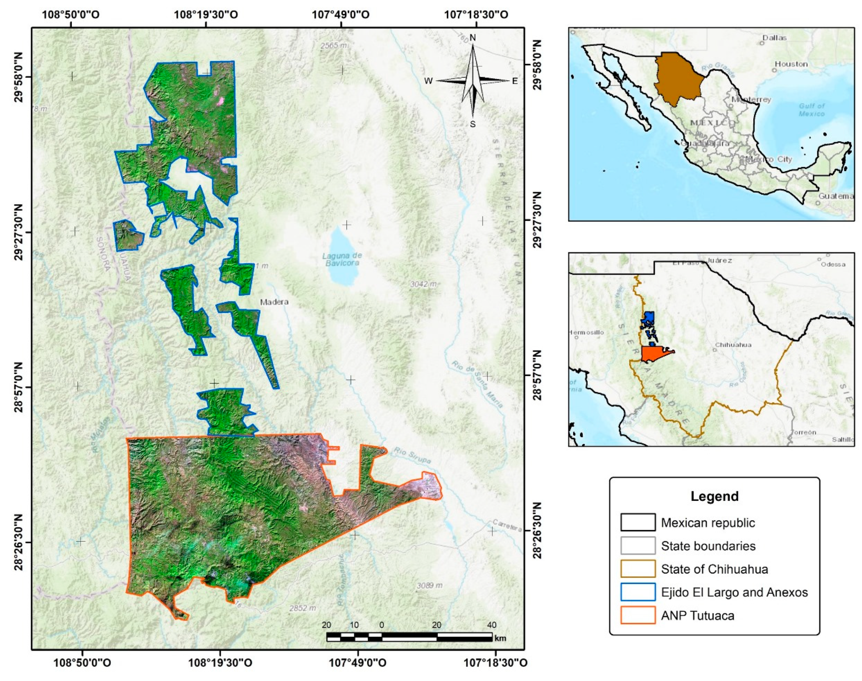
Figure 2.
Flowchart of the methodological framework applied in the study.
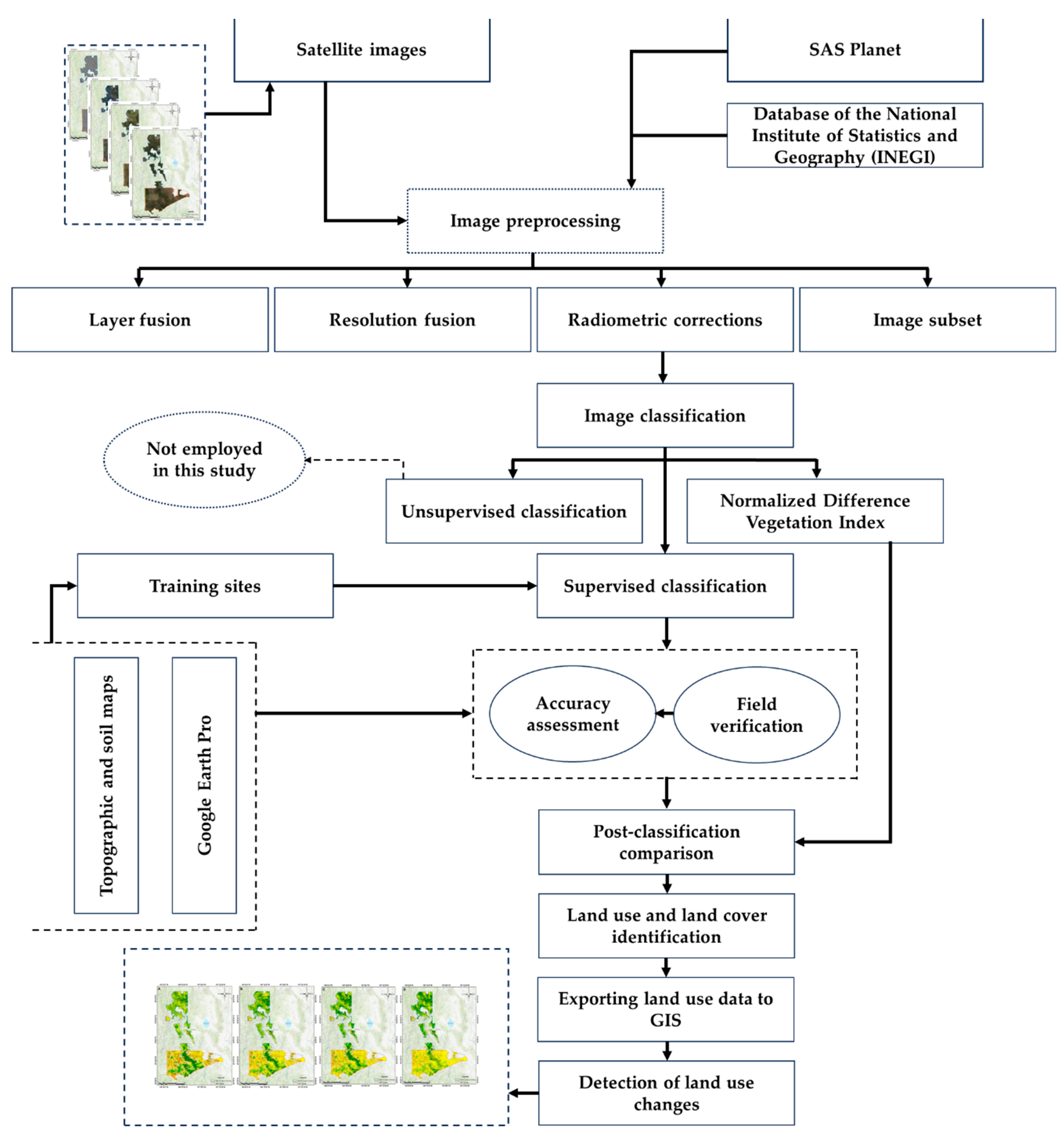
Figure 3.
Orthomosaics of Ejido El Largo y Anexos and the Tutuaca Protected Natural Area, Chihuahua, for the years 1995 (A), 2008 (B), 2014 (C), and 2022 (D).
Figure 3.
Orthomosaics of Ejido El Largo y Anexos and the Tutuaca Protected Natural Area, Chihuahua, for the years 1995 (A), 2008 (B), 2014 (C), and 2022 (D).
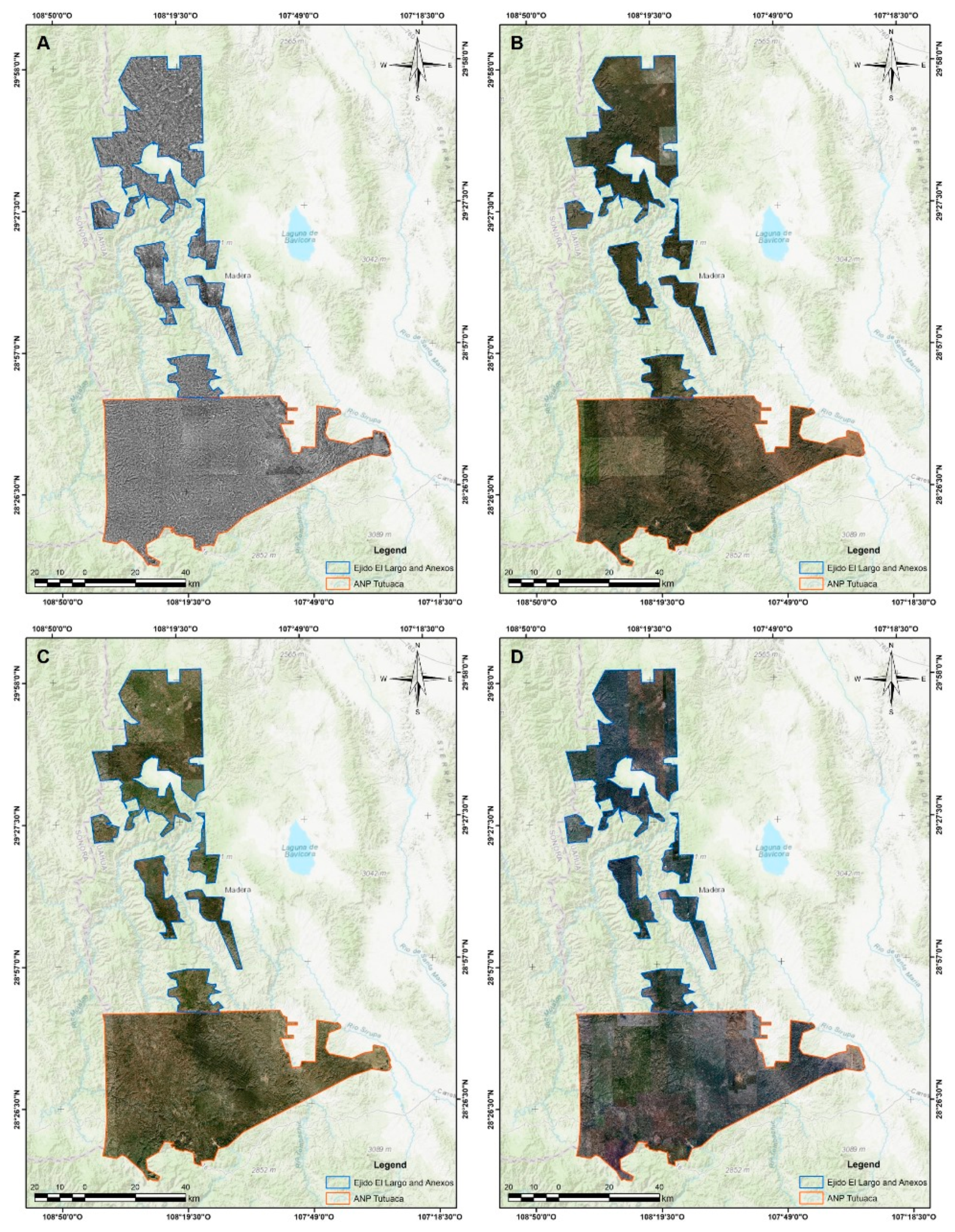
Figure 4.
Evolution of vegetation cover in Ejido El Largo y Anexos and the Tutuaca Protected Natural Area (ANP) (1995-2022).
Figure 4.
Evolution of vegetation cover in Ejido El Largo y Anexos and the Tutuaca Protected Natural Area (ANP) (1995-2022).
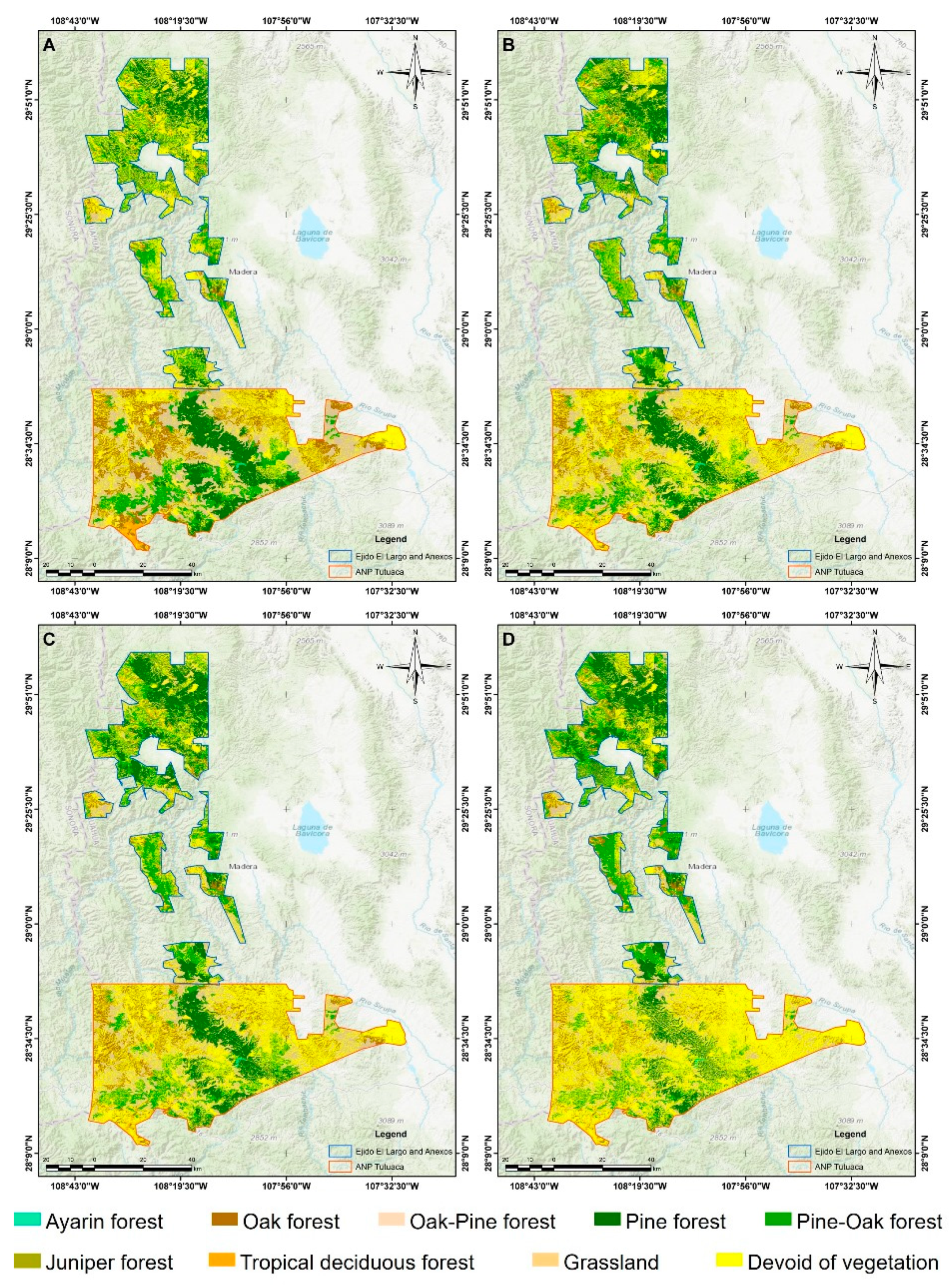
Figure 5.
Relative change in land cover in Ejido El Largo y Anexos and the Tutuaca Protected Natural Area (PNA) (1995-2022).
Figure 5.
Relative change in land cover in Ejido El Largo y Anexos and the Tutuaca Protected Natural Area (PNA) (1995-2022).
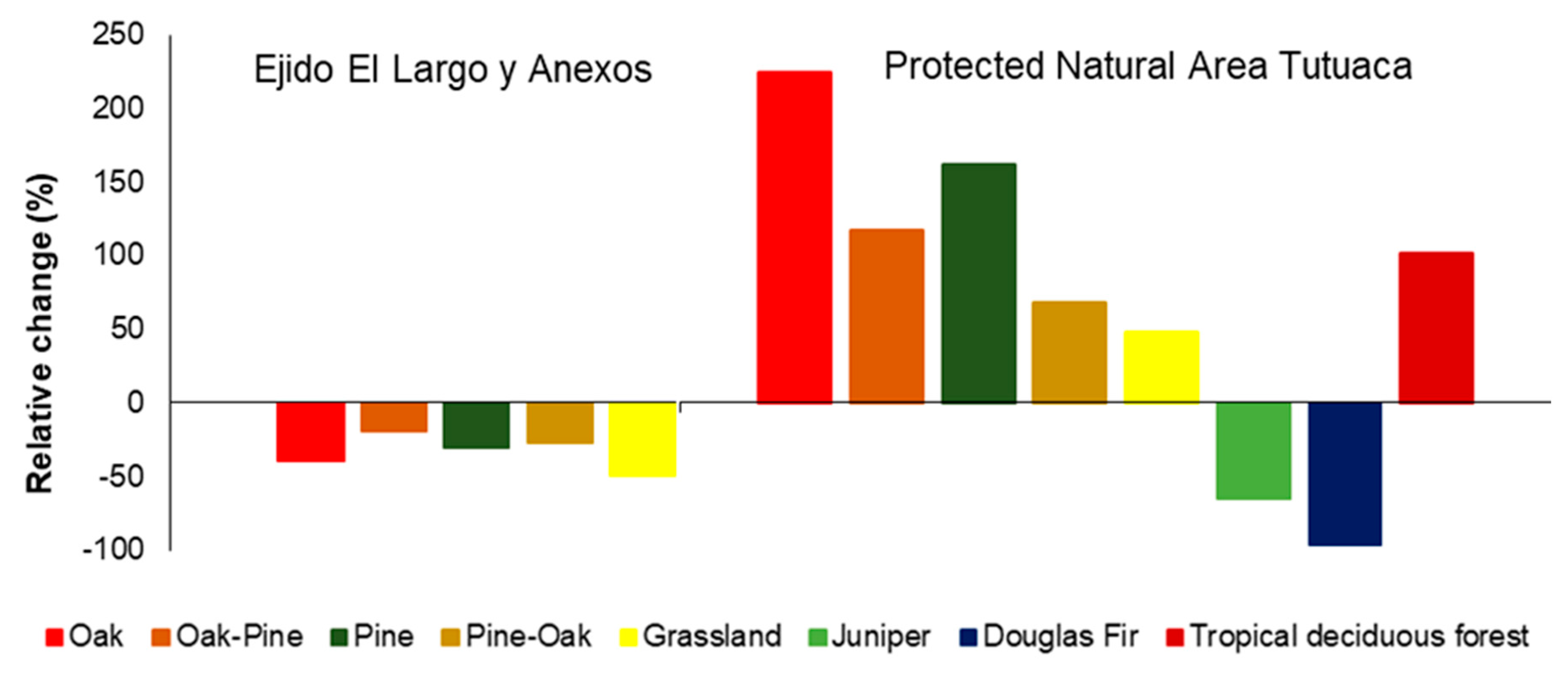
Figure 6.
Contrast of the overall deforestation rates between Ejido El Largo y Anexos, and the Tutuaca National Park (PNA).
Figure 6.
Contrast of the overall deforestation rates between Ejido El Largo y Anexos, and the Tutuaca National Park (PNA).
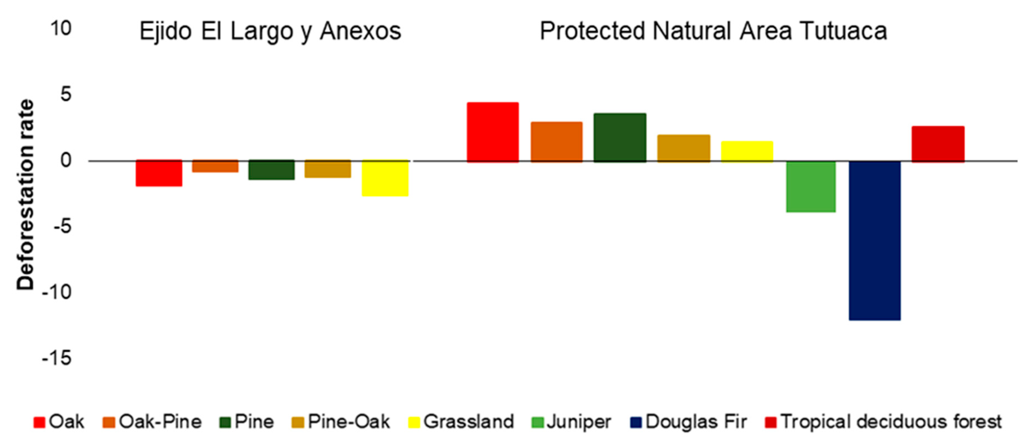
Figure 7.
Deforestation rates by ecosystem type over the period from 1995 to 2022 in Ejido El Largo y Anexos, and Tutuaca National Park (PNA).
Figure 7.
Deforestation rates by ecosystem type over the period from 1995 to 2022 in Ejido El Largo y Anexos, and Tutuaca National Park (PNA).
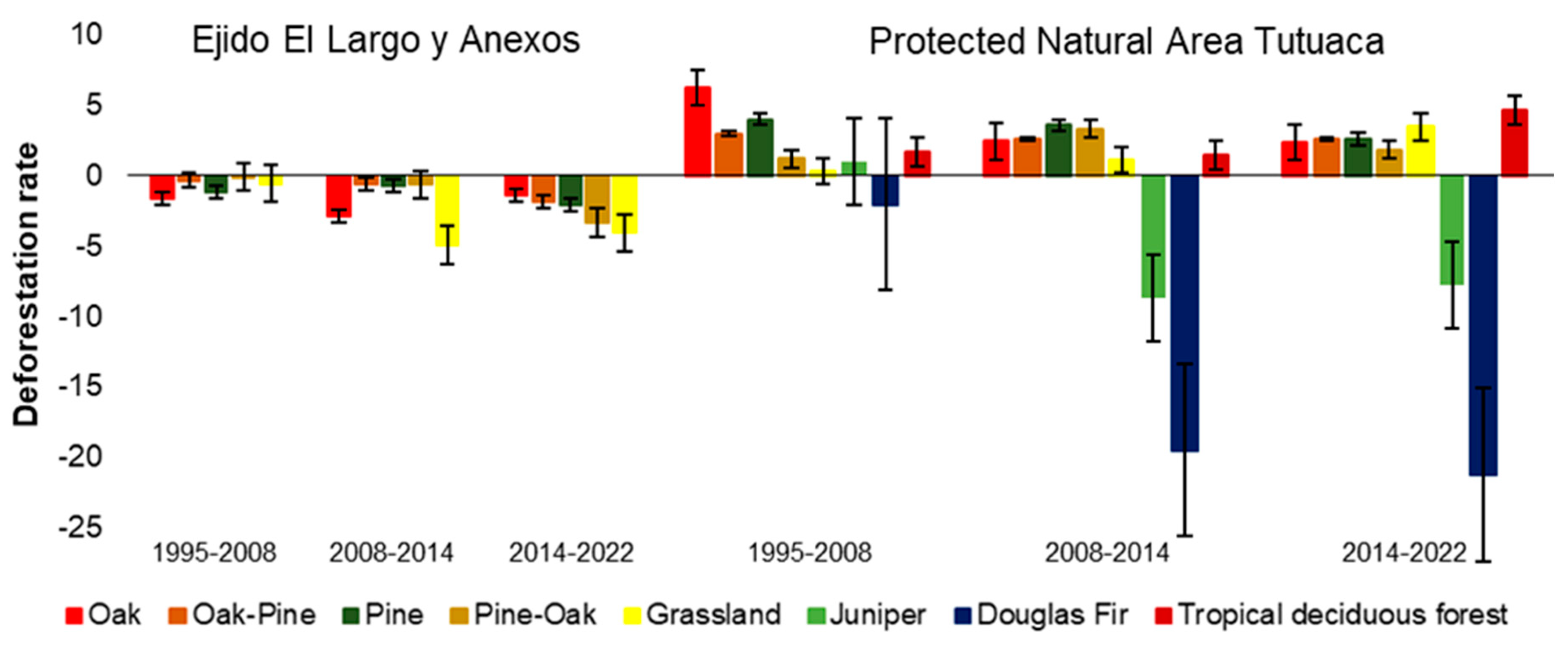

Table 1.
Vegetation surface cover by ecosystem type in the Ejido El Largo y Anexos and the Tutuaca Protected Natural Area at the years 1995, 2008, 2014, and 2022..
Table 1.
Vegetation surface cover by ecosystem type in the Ejido El Largo y Anexos and the Tutuaca Protected Natural Area at the years 1995, 2008, 2014, and 2022..
| Ecosystem | 1995 | 2008 | 2014 | 2022 | ||||
|---|---|---|---|---|---|---|---|---|
| ha | % | ha | % | ha | % | ha | % | |
| Ejido El Largo y Anexos | ||||||||
| Oak | 23,972 | 22.81 | 19,325 | 20.32 | 16,237 | 18.38 | 14,501 | 19.89 |
| Oak-Pine | 13,969 | 13.29 | 13,421 | 14.11 | 12,972 | 14.69 | 11,230 | 15.40 |
| Pine | 29,915 | 28.46 | 25,708 | 27.03 | 24,643 | 27.90 | 20,871 | 28.62 |
| Pine-Oak | 33,323 | 31.71 | 32,986 | 34.69 | 31,755 | 35.95 | 24,347 | 33.39 |
| Grassland | 3,922 | 3.73 | 3,657 | 3.85 | 2,716 | 3.08 | 1,965 | 2.69 |
| Summation | 105,101 | 100.00 | 95,097 | 100.00 | 88,323 | 100.00 | 72,914 | 100.00 |
| Protected Natural Area Tutuaca | ||||||||
| Douglas Fir | 242 | 0.27 | 184 | 0.13 | 56 | 0.03 | 10 | 0.00 |
| Oak | 22,621 | 25.55 | 51,981 | 36.75 | 60,354 | 36.38 | 73,249 | 35.93 |
| Oak-Pine | 28,770 | 32.49 | 42,824 | 30.28 | 50,296 | 30.32 | 62,442 | 30.63 |
| Pine | 8,461 | 9.55 | 14,373 | 10.16 | 17,896 | 10.79 | 22,135 | 10.86 |
| Pine-Oak | 15,880 | 17.93 | 18,648 | 13.19 | 22,879 | 13.79 | 26,621 | 13.06 |
| Juniper | 7 | 0.01 | 8 | 0.01 | 5 | 0.00 | 2 | 0.00 |
| Grassland | 11,085 | 12.52 | 11,547 | 8.16 | 12,374 | 7.46 | 16,413 | 8.05 |
| Tropical deciduous forest | 1,487.83 | 1.68 | 1,865.96 | 1.32 | 2,044.22 | 1.23 | 2,998 | 1.47 |
| Summation | 88,553.85 | 100.00 | 141,430.13 | 100.00 | 165,903.94 | 100.00 | 203,870 | 100.00 |
Disclaimer/Publisher’s Note: The statements, opinions and data contained in all publications are solely those of the individual author(s) and contributor(s) and not of MDPI and/or the editor(s). MDPI and/or the editor(s) disclaim responsibility for any injury to people or property resulting from any ideas, methods, instructions or products referred to in the content. |
© 2024 by the authors. Licensee MDPI, Basel, Switzerland. This article is an open access article distributed under the terms and conditions of the Creative Commons Attribution (CC BY) license (http://creativecommons.org/licenses/by/4.0/).
Copyright: This open access article is published under a Creative Commons CC BY 4.0 license, which permit the free download, distribution, and reuse, provided that the author and preprint are cited in any reuse.


