
Submitted:
27 February 2024
Posted:
27 February 2024
You are already at the latest version
Abstract
Floods are among the most serious natural disasters worldwide; they cause enormous crop losses every year and threaten world food security. There are many studies focused on flood impact assessments for administrative districts but fewer on postdisaster impact assessments for specific crops. Therefore, this study used remote sensing data, including the normalized difference vegetation index (NDVI), elevation data, slope data, and rainfall data, combined with crop growing season data to construct a crop flood damage assessment index (CFAI). First, an analytic hierarchy process (AHP) was used to assign weights to the impact factors; then, the weighted composite score method was used to calculate the CFAI; and finally, the impact was classified as slight, moderate, or severe based on the magnitude of the CFAI . This method was used for the Missouri River floods of 2019 in the U.S. Due to the lack of measured data, the disaster vegetation damage index (DVDI) was used to validate the results. The combined approach achieved a high degree of consistency in spatial distribution. The CFAI can respond well to the degree of crop impact after flooding, providing new ideas and reference standards for agriculture-related departments.
Keywords:
flooding
; crop damage assessment
; analytic hierarchy process
1. Introduction
Flooding is one of the most serious agricultural disasters and can cause extensive agricultural losses, leading to reduced crop production or even crop failure [1,2]. Every year, agricultural production activities are affected by floods [3], and recent climate change impacts may exacerbate crop production losses due to floods [4,5,6,7]. Therefore, timely and rapid crop damage assessment is very helpful for disaster mitigation and relief, crop insurance claims, and providing information to government emergency departments. Traditional crop damage assessment methods rely on human labor to conduct field surveys; however, these methods are slow, costly, and highly subjective [8]. Therefore, a more economical, convenient and easily accessible method is needed for crop loss assessment, and remote sensing technology has the advantages of wide spatial coverage, objectivity and low cost; thus, remote sensing has become the preferred method for crop loss assessment.
Currently, remote sensing-based flood crop loss assessment methods are mainly categorized into three types: flood intensity-based crop loss assessment, crop condition-based crop loss assessment, and model-based crop loss assessment [9]. Crop loss based on flood intensity is usually assessed in terms of crop inundation area, which is very general and does not consider the impact to the crop itself. Although the extent of flood inundation is an evident factor, this method only considers the area of inundation and does not consider the extent of crop damage, nor does it allow for crop-specific damage estimates. In addition, inundated crops may not necessarily be damaged, so overestimation of the damage is possible. Flood information such as flood depth, duration, flow rate, and seasonality has also been used for assessment. Waisurasingha and Pacetti used flood depth thresholds of 80 cm and 100 cm to determine crop damage [10,11]. Dutta and Kwak utilized crop-specific depth‒damage curves to obtain accurate estimates of crop damage [12,13]. If the focus of the disaster assessment is on a single crop type, a general flood depth curve or threshold can be used. However, actual crops are diverse and complex. Depth‒damage curves allow continuous damage assessment at any flood depth, whereas damage assessment using depth categories or thresholds generalizes damage over a range of depth categories. The use of flood depth information and inundation extent aids in the accurate assessment of damage. Forte et al. used generalized depth‒damage curves for the agricultural sector for damage assessment [14]. Similarly, Silva-Aguila et al. utilized four damage classes corresponding to four flood depth classes for assessment [15]. The main drawback of these studies is the use of a generic curve or class for all crop types. Such generalized assumptions may lead to overestimation or underestimation of crop losses. Furthermore, different crop types have different tolerance levels to flood depths. Therefore, it is important to consider separate depth‒damage curves for different crop types.
Crop loss assessments based on crop conditions mainly assess the impact of floods on vegetation growth, and these assessments are largely based on vegetation indices and comparisons of vegetation indices before and after a disaster or use methods such as regression analysis between vegetation indices and crop yields. The vegetation indices used for crop loss assessment can be broadly categorized into two types: vegetation indices calculated directly from remotely sensed bands (e.g., NDVI, EVI, and SAVI) and new vegetation indices developed from other vegetation indices (e.g., VCI and DVDI) [16,17,18,19]. While some vegetation indices were originally developed to monitor the impact of drought on crops, many recent studies have used them in the context of other hazards, such as floods. Shrestha et al. compared MODIS NDVI time series data with historical NDVI medians from 2000–2014, revealing the impact of floods on crops [20]. Yu et al. concluded that all of the vegetation indices are capable of detecting the impact of floods on crops, and the VCI provides a better estimate of vegetation damage than the RMVCI and MVCI [21]. Di et al. successfully assessed the extent of crop damage associated with the 2011 Missouri River flood event using the DVDI [22]. The use of vegetation indices for flood crop damage assessment requires recognizing the effect of outliers, mainly clouds, in the imagery; these outliers are more influential because there are more clouds before and after heavy rainfall, so removing the effect of clouds is a key issue. The advantage of regression modeling is that it can provide a quantitative assessment of loss, which can be expressed as a reduction in postdisaster yields compared to historically normal yields. Silleos et al. developed a linear regression model using the normalized difference vegetation index (NDVI) and loss rates collected from field surveys [23]. Similarly, Shrestha et al. used a linear regression model relating the rate of change in the NDVI to the rate of change in the yield of pure maize-like elements for maize loss assessment in the U.S. [24]. Huang J used the correlation between NDVI data and yields to determine the area of the crop planted as well as the optimal period for reliable estimation [25]. Shammi explored how to use the NDVI-derived vegetative growth metric (VGM) to model crop yields in different regions of the U.S. [26]. Galphade used weather data and NDVI time series data to predict crop yields. These regression-based methods usually require historical data on yield and independent variables to construct regression equations [27]. Therefore, regression modeling cannot be used in areas where historical data are lacking.
There are many crop loss assessment models, such as the Hazards US (HAZUS) model, impact analysis for planning (IMPLAN) model, and methods for evaluating direct and indirect losses (MEDIS) model [28]. The HAZUS is one of the most popular flood crop hazard assessment models [29]. Although the HAZUS model was developed primarily for the United States, many studies worldwide have used the HAZUS model for crop loss assessment using local input parameters. Like in the HAZUS model, the MEDIS model is widely used in European countries, especially in Germany [30]. The HAZUS and MEDIS models both include extensive national databases embedded in their software [31]. Forete et al. used Landsat imagery, aerial imagery, and digital terrain models (DTMs) for land cover mapping, flood extent depiction and flood depth calculation, respectively [14]. These land cover maps and flood information were used as inputs to the HAZUS model for crop loss assessment in Italy. Similarly, Tapia-Silva et al. and Förster et al. used the MEDIS model to estimate crop losses for the 2002 Elbe River flood [32,33]. These models apply the concept of risk functions to hazards, vulnerabilities and risk factors. The flood intensity (extent, depth and duration) was used as a hazard parameter. Crop-specific vulnerability is expressed as a depth‒duration–damage curve. Damage is then typically assessed in monetary terms using damage coefficients and crop prices. Crow evaluated the HAZUS crop loss modeling methodology through a case study of the 2011 Iowa floods, and she concluded that the HAZUS model overestimated losses [34]. A possible reason for this difference is that crop condition and crop type information are not considered in the model-based assessment. Flooded farmland does not necessarily mean significant crop losses. In addition, model assessments are too general and do not consider crop type; for example, soybeans may suffer more damage from short-term flood events than corn. Crow also mentioned that the most critical factor in HAZUS models is the delineation of the flooded area, which tends to overestimate the actual flooded area [34]. In addition, these models are built for specific geographic areas and may not be applicable to other areas unless significant changes are made to make them appropriate for the study area. Moreover, these models often rely on ancillary data, which are also more difficult to obtain in some areas, further limiting the extent to which these models can be used.
To solve the above problems, this study proposed a new index to measure the impact of floods on crop yields, called the crop flood damage assessment index (CFAI). We used this index to measure the extent of flood damage to crops. The objective of this study is to construct the CFAI and use the CFAI to assess the impact of floods on crops.
2. Materials
2.1. Study Area
The Missouri River is one of the major rivers in the U.S. and the longest river in North America. The Missouri River Basin is prone to flooding due to short-term storms or prolonged rainfall, as well as spring snowmelt. In March 2019, a major flood event occurred in the Missouri River Basin. This flood event began on 18 March when a levee on the upper Missouri River collapsed, causing water levels in the lower Missouri River to exceed its banks and causing flooding in the Missouri River from Omaha to Kansas City, along the tri-state border of Nebraska, Iowa, and Kansas. Flooding was rampant in the watershed. The main feature on both banks of this basin was cropland, and at the time of flooding, the main crop was spring wheat, which was affected by flooding. Therefore, this area was selected as the study area, and the specific area is shown in Figure 1.
2.2. Research Data
2.2.1. Sentinel-2 Data
The Sentinel-2 satellite features a multispectral imaging device with an altitude of 786 km, covering 13 spectral bands and a width of 290 km. The spatial resolutions are 10 m, 20 m and 60 m, the revisit period of one satellite is 10 days, and the revisit period of two complementary satellites is 5 days. As the highest spatial resolution multispectral remote sensing data available free of charge, Sentinel-2 data are widely used in various fields. The Sentinel-2 data can be downloaded from the ESA official website (https://scihub.copernicus.eu/dhus/#/home). The purpose of utilizing Sentinel-2 data in this paper is to determine the extent of flood inundation. In this study, all the Sentinel image data from 18th March to 24th March in each year of 2018 and 2019 were selected for flood area extraction.
2.2.2. MODIS Data
The Moderate Resolution Imaging Spectroradiometer (MODIS) is onboard the Terra and Aqua satellites. It has 36 spectral bands at moderate resolution and observes the Earth’s surface every 1-2 days with a spatial resolution of up to 250 m. MODIS data can be downloaded from the NASA website (https://ladsweb.modaps.eosdis.nasa.gov). The MOD09 reflectance product was used in this paper to calculate the NDVI, primarily to obtain NDVI data for the previous 10 years in the same location prior to the flood. In this study, the NDVI change values were calculated for 19 March 2019, 20 March 2019, 21 March 2019, and 22 March 2019 based on NDVI data for the previous 10 years in the same location at the same time before the flood. These data are shown in Figure 2.
2.2.3. Elevation and Slope Data
The SRTM90mDEM is a digital elevation model that provides a spatial resolution of 90 meters, and these data can be used to generate topographic and slope maps. The elevation and slope data can be downloaded from the Geospatial Data Cloud website (https://www.gscloud.cn/). Elevation and slope can have an impact on flood distribution; therefore, elevation and slope are analyzed as impact factors in this paper. The elevation and slope distribution of the study area are shown in Figure 3.
2.2.4. Precipitation Data
The Climate Hazards Group InfraRed Precipitation with Station (CHIRPS) dataset contains global precipitation data. The dataset combines satellite infrared information and ground-based meteorological station data to provide global precipitation estimates from 1981 to the present. The CHIRPS dataset has a high temporal resolution (daily, decadal, monthly) and a high spatial resolution (0.05°), which allows it to provide accurate, timely, and reliable precipitation data for climate research, disaster risk assessment, and other applications. The CHIRPS data can be downloaded from the Google Earth Engine platform (https://earthengine.google.com/). Rainfall is a causal factor of flooding, so CHIRPS daily rainfall data was used for disaster assessment. The cumulative rainfall of the week
prior to the disaster was used, and the specific distribution of the cumulative precipitation is shown in Figure 4.
2.2.5. Growth Period
Flood duration varies, and flooding harms crops differently during different growth periods; therefore, it is necessary to consider the growing period as an impact factor. In this study, the 2019 Missouri River flood event was used as a case study; therefore, the main affected crop selected was winter wheat, which was divided into eight growth stages based on the growth pattern of winter wheat, namely, emergence, green-up, tillering, jointing, heading, grain filling, and maturity. The green-up stage occurred at the time of the flood.
3. Methods
3.1. Model
The construction of this model can be divided into three parts: influencing factor selection and grading, determination of influencing factor weights, and construction of a crop flood damage assessment index. The NDVI, cumulative precipitation, DEM, slope, and growing period were selected as the main factors. These five factors were used to objectively and comprehensively express the degree to which crops were affected by flooding. Then, an analytic hierarchy process was used to determine the weights of these five parameters in different directions and at different scales. Finally, the weighted integrated scoring method was used to calculate the size of the affected image area according to the magnitude of index to evaluate the impact. The specific process is shown in Figure 5.
3.1.1. Selection and Grading of Impact Factors
In this study, five factors, namely, the normalized difference vegetation index (NDVI), cumulative precipitation, relative elevation, slope, and growing period, were selected to determine the degree of crop damage. The NDVI is a remote sensing vegetation index that quantifies vegetation growth by calculating the difference between the near-infrared and infrared bands. In general, the higher the NDVI is, the more vigorous the crop growth. In addition, the NDVI is also used to invert crop yield, and many scholars have proven that there is a strong correlation between the NDVI and yield [35,36,37,38]. Therefore, the change in the NDVI can be used to measure the extent of flood impacts on crops. To quickly obtain the degree of crop damage after the disaster, prior knowledge was used. The NDVI was obtained for the year of the disaster, then the average NDVI value for the first 10 years following the disaster in the same region was calculated. This method can quickly obtain the degree of change in NDVI after the disaster which is needed for the assessment of the degree of crop damage.
The depth of inundation is one of the most important factors for determining the extent of flood impact on crops, but it is difficult to obtain precise data for this parameter. Therefore, we chose to use the cumulative precipitation, relative elevation and slope to reflect the inundation depth simultaneously. The greater the cumulative precipitation is, the lower the relative elevation and the lower the slope are, and the greater the inundation depth is.
The crop growing period is one of the impact factors. Flooding has different impacts on crops during different growth periods, and flooding during the early growth period usually has less impact on growth because crops tend to have long growing seasons and because replanting can be used to reduce losses; additionally, the self-healing ability of crops should be considered. During the middle stage of growth, crop growth is lush, respiration is vigorous, and pollen transfer occurs; thus, during this period, the flooding-related growth damage is high. In the late growth period, crops are maturing, so flooding can be harmful to crop fruits, and prolonged immersion may produce qualitative changes; thus, flooding during the period when crops are maturing is also a great hazard. The combination of these factors makes our assessment method more comprehensive and accurate.
There are different levels and units for each influencing factor, and the range of attribute values varies greatly; therefore, to facilitate calculation, it is necessary to grade the raw data and choose the natural breakpoint method or grade according to national and local standards in the grading method. The grading results are assigned values according to the degree of crop damage and the degree of damage to crops. The grading and assignment results are shown in Table 1.
3.1.2. Determining the Weights of Impact Factors
Since the factors impacting the affected crops vary, it is necessary to assign different weights to different impact factors according to the actual situation. There are many methods for determining the weights of impact factors, and the analytic hierarchy process method has many advantages as a basis for decision-making; this method can reflect the main factors of the degree of crop damage in the study area and is targeted, indirect, practical and systematic [39]. Qualitative and quantitative analysis are combined to analyze and interpret complex systems according to a hierarchical and quantitative approach. The advantage of this approach is that it simplifies complex problems, is simple to calculate, and is commonly used in assessment and evaluation. Therefore, in this study, the analytic hierarchy process (AHP) proposed by T.L. Saaty was used for determining the weights of the impact factors [40]. The main process includes constructing a judgment matrix through two-by-two comparisons of indicators, assigning weights to each influencing factor and its evaluation indicators by combining expert opinions, and deriving the weights of each influencing factor through a unit-root test.
The judgment matrix is shown in Table 2. The numbers in the table represent the following: 1: equally important; 3: slightly important; 5: obviously important; 7: strongly important; 9: extremely important; 2, 4, 6 and 8 represent the medians of the above two neighboring judgments; and in addition, the judgment of i and j is ; then, the judgment of j and i is .
3.1.3. Construction of the Crop Flood Damage Assessment Index
The establishment of a comprehensive assessment index is one of the main methods for studying disaster assessment; the degree of crop damage is the result of a variety of factors, and the directions of influence of each influencing factor are not the same [41,42]. In this study, the weighted composite score method was used to establish the following crop flood damage assessment index:
where: CFAI is the crop flood damage assessment index; N is NDVI change value; is the NDVI change value weight; W is the cumulative precipitation; is the cumulative precipitation weight; G is the growing period; is the growing period weight; H is the relative elevation; is the relative elevation weight; S is the slope; is the slope weight.
When grading the results of the composite assessment index, we defined three impact categories: slight, moderate, and severe. Areas with a CFAI between 1 and 2 are considered slightly impacted, those between 2 and 3 are moderately impacted, and values greater than 3 are considered severely impacted areas.
4. Results
4.1. Extent of Flood Inundation
Floods are caused by water inundation, so the identification and extraction of water bodies is crucial in flood monitoring. To date, a variety of water body indices have been proposed and applied to water body extraction. The more classical water body index is the normalized difference water index (NDWI), which was proposed by McFeeters and is calculated using the near-infrared (NIR) and green (green) bands [43]. The formula is as follows:
This study utilized postdisaster and predisaster Sentinel 2 data with the help of the NDWI to extract the extent of change in the water bodies in the study area before and after heavy rainfall to determine the extent of flood inundation. The land use map of the study area was then superimposed to determine the extent to which the inundation of crops was affected by flooding, as shown in Figure 6.
We extracted the extent of water bodies in the same area for 2018 and 2019 using the NDWI. The extent of water bodies in the area increased significantly, and the extent of water bodies extracted for 2019 subtracting the extent of water bodies in 2018 was the extent of inundation for this flooding event.
4.2. Crop Damage Assessment
4.2.1. Weight Determination
The change in NDVI was taken as the most important factor in the present study because the change in NDVI is the most intuitive reflection of crop growth status and can indirectly indicate the impact of flooding on crop yield. Since the flood in this study area was caused by a dike failure, we considered the contribution of precipitation to the timing of this flood to be small and therefore ranked it last in the importance ranking. The area has a low elevation and slope, which can reflect the degree of flood aggregation, and the impact of the disaster will be more severe when the elevation and slope are lower. The parameters of the growing period were also combined considering that crops during different growing periods have different resistances to flooding and self-healing abilities and that measures such as replanting can be taken to compensate for losses in the early growing period. After comprehensive consideration, the overall importances were ranked as follows: NDVI, relative elevation, slope, growing period, and cumulative precipitation. The judgment matrix is shown in Table 2. The results passed the unit-root test, and the weighted values of each influencing factor were obtained; the results are shown in Table 3 and Table 4.
4.2.2. Assessment Results
In this paper, MODIS reflectance data were used to calculate the NDVI from 18 to 22 March 2019. Digital elevation and slope data from the study area were obtained, and cumulative precipitation data for the week before the disaster and for the growing season in which the crops were in at the time of the disaster were used to calculate the crop flood assessment index. Additionally, based on the results of the index, the damage was divided into three levels, namely, slight, moderate and severe. Based on this method, time series monitoring was carried out to track the development and impact of flooding. The assessment results are shown in Figure 7.
This flooding occurred early in the crop growing period, so overall, we believe that the impact of flooding on crops was relatively slight. Of the affected areas, most areas were slightly damaged, while a small percentage were severely damaged. In addition, the severely and moderately damaged areas are mainly concentrated in the upper reaches because they are more strongly affected by floods. Temporally, the slightly damaged areas gradually shrink over time, while the moderately and severely damaged areas gradually expand. Geographically, areas in the upper reaches are more severely affected. The main affected areas are located on both sides of the basin.
4.3. Validation of the Damage Assessment Results
Since plot-level data are not publicly available, it was not possible to use plot-level yield loss data for model validation. We used the Disaster Vegetation Damage Index (DVDI) developed by Di for result validation [8]. This method has achieved good results in natural disaster damage assessments, such as flood and typhoon damage. The main calculation process of the method is as follows:
First, the mean vegetation condition index (mVCI) was calculated, where represents the median value of the NDVI historical series and represents the maximum value of the NDVI historical series.
where and represent the vegetation conditions after and before the disaster, respectively. The DVDI grading method was modified in this study because we divided the damage level into three categories as follows: -0.2<DVDI, slight impact; 0.4<=DVDI<-0.2, moderate impact; and DVDI<-0.4, severe impact. In addition, since the results above were obtained via time series monitoring, to compare with the DVDI, data were also extracted from the same two temporal windows as the DVDI before and after the disaster for index calculations and to compare the results. The results are shown in Figure 8.
As shown in Figure 7, the results of the two distributions are generally similar, considering that the areas of slight impact are mainly located in the north and some peripheral areas, the areas of severe impact are mainly located in the center, and the areas of moderate impact are mainly located in the south. In terms of details, there are still some differences. In terms of distribution, compared with the DVDI results, the CFAI results reveal that the severely impacted area is slightly smaller, but the slightly impacted area is larger. In terms of impact distribution, the CFAI assessment results reveal slightly impacted areas from north to south, but the DVDI classified minor impact areas mainly in the north. Although both detected severe impact areas in the center, the CFAI assessment generated a smaller severe impact area than did the DVDI classification.
The results of the distribution of the impact levels of the two methods were further tabulated and are shown in Table 5.
The DVDI overestimates the proportion of each impact level compared to the CFAI model. This may be mainly because DVDI uses longer time series of NDVI data, and optical images are easily contaminated by atmospheric factors, cloud cover and other factors, which may have an impact on the final results. In addition, the DVDI focuses mainly on the variability of crops without considering the topography and elevation data that affect flood distribution, as well as the rainfall factors related to floods and differences in crop resilience at different stages of the growing season. These factors are very important in flood assessments. In contrast, we included these factors in the calculation of the CFAI, allowing the assessment results to be more objective and comprehensive. This approach considers not only crop variations but also the distribution and factors influencing floods and therefore provides a more comprehensive flood hazard assessment.
5. Discussion
Although the crop flood damage assessment methodology proposed in this paper can be used to quickly assess crop damage, there are still several limitations and constraints associated with this methodology. First, the use of remotely sensed data to extract flood inundation areas may lead to underestimation or overestimation of the actual flood extent. Second, the delineation of the extent of damage needs to be adapted to different geographic settings and crop types, which adds to the complexity of the assessment. In addition, heavy rainfall-induced flooding usually precedes and is followed by thick cloud cover, which can be problematic for extracting flood extents and calculating the NDVI using optical data. This may affect the accuracy of the assessment results. Finally, due to the confidentiality of plot-level data, we were unable to obtain real and valid data for validation, which made it difficult to compare our method with the actual situation to verify its accuracy and reliability.
While there are still some shortcomings in using qualitative methods based on crop flood damage assessment indices, their unique advantages endow them with great potential and value in practical application. First, the data are easily accessible. The whole assessment process relies mainly on freely available remote sensing data, so its application is not limited by time or location. Second, this approach does not require a large amount of survey or historical data. Survey and historical data are scarce in many developing countries, which makes this assessment method advantageous in resource-limited environments. Third, rapid assessment is possible. This methodology can provide rapid assessments immediately after a flood, which is invaluable in determining disaster risk reduction responses and decision-making. Fourth, the method is more objective. Factors such as topography and growing period are also accounted for in calculating the index, thus providing a more objective reflection of the extent of disaster-related impacts on crops. Therefore, our methodology is useful for both developed and developing countries. Moreover, our research methodology facilitates rapid assessment of losses to support immediate policy and decision-making needs. These advantages give our methodology great potential and value in practical applications.
6. Conclusion
In this study, we selected the watershed spanning Omaha to Kansas City as the study area, using the 2019 Missouri River flood basin as an example. First, we extracted the affected areas using the normalized difference water index (NDWI), and combined with the land-use map, we extracted the crop-affected areas in this study area. Next, we constructed a crop flood damage assessment index by applying the AHP to calculate the weight of each factor with the input of the NDVI data provided by NASA, the DEM and slope data, and the daily rainfall data from the CHIRPS precipitation dataset; additionally, we included the growing period of crops as a factor. The magnitude of the crop flood damage assessment index was used to classify the agricultural disaster zones into three levels (slight, moderate and severe impact), and conducted time-series monitoring based on this method. The results showed that the overall impact of flooding on crops was slight because the flood occurred during the early stages of crop growth. The slightly impacted area was the largest, the severely impacted area was the smallest, and the areas impacted severely and moderately were mainly located in the southern region. In terms of the temporal distribution, as time passes, the severely and lightly affected areas gradually shrink, and the moderately affected areas gradually expand. Finally, we also used the DVDI for comparison with the CFAI, and the results showed a high degree of consistency between the two indices. Therefore, we conclude that the CFAI can be effectively applied to crop damage assessment during flood events.
Author Contributions
Conceptualization, Yaoshuai Dang and Jinling Song; Methodology, Yaoshuai Dang, Leiku Yang and Jinling Song; Resources, Leiku Yang; Supervision, Jinling Song; Validation, Leiku Yang; Writing – review & editing, Yaoshuai Dang and Jinling Song.
Funding
This work was supported by the National Natural Science Foundation of China Major Program(42192580, 42192584) and National Natural Science Foundation of China(41975036).
Conflicts of Interest
The authors declare no conflict of interest.
References
- Di L, Eugene G Y, Kang L, et al. RF-CLASS: A remote-sensing-based flood crop loss assessment cyber-service system for supporting crop statistics and insurance decision-making[J]. Journal of integrative agriculture 2017, 16, 408–423. [CrossRef]
- Tapia-Silva F O, Itzerott S, Foerster S, et al. Estimation of flood losses to agricultural crops using remote sensing[J]. Physics and Chemistry of the Earth, Parts A/B/C 2011, 36, 253–265. [CrossRef]
- Chen H, Liang Q, Liang Z, et al. Remote-sensing disturbance detection index to identify spatio-temporal varying flood impact on crop production[J]. Agricultural and Forest Meteorology 2019, 269, 180–191.
- Aerts JC, J.H.; Botzen WJ, W. Climate change impacts on pricing long-term flood insurance: A comprehensive study for the Netherlands[J]. Global environmental change 2011, 21, 1045–1060. [Google Scholar] [CrossRef]
- Bouwer, L.M. Have disaster losses increased due to anthropogenic climate change[J]. Bulletin of the American Meteorological Society 2011, 92, 39–46. [Google Scholar] [CrossRef]
- Managing the risks of extreme events and disasters to advance climate change adaptation: special report of the intergovernmental panel on climate change[M]. Cambridge University Press, 2012.
- Hirabayashi Y, Mahendran R, Koirala S, et al. Global flood risk under climate change[J]. Nature climate change 2013, 3, 816–821. [CrossRef]
- Di, S.; Guo, L.; Lin, L. Rapid estimation of flood crop loss by using DVDI[C]//2018 7th International Conference on Agro-geoinformatics (Agro-geoinformatics). IEEE, 2018: 1-4.
- Rahman, M.S.; Di, L. A systematic review on case studies of remote-sensing-based flood crop loss assessment[J]. Agriculture 2020, 10, 131. [Google Scholar] [CrossRef]
- Waisurasingha C, Aniya M, Hirano A, et al. Use of RADARSAT-1 data and a digital elevation model to assess flood damage and improve rice production in the lower part of the Chi River Basin, Thailand[J]. International Journal of Remote Sensing 2008, 29, 5837–5850. [CrossRef]
- Pacetti, T.; Caporali, E.; Rulli, M.C. Floods and food security: A method to estimate the effect of inundation on crops availability[J]. Advances in water resources 2017, 110, 494–504. [Google Scholar] [CrossRef]
- Dutta, D.; Herath, S.; Musiake, K. A mathematical model for flood loss estimation[J]. Journal of hydrology 2003, 277, 24–49. [Google Scholar] [CrossRef]
- Kwak Y, Shrestha B B, Yorozuya A, et al. Rapid damage assessment of rice crop after large-scale flood in the cambodian floodplain using temporal spatial data[J]. IEEE Journal of Selected Topics in Applied Earth Observations and Remote Sensing 2015, 8, 3700–3709. [CrossRef]
- Forte, F.; Strobl, R.O.; Pennetta, L. A methodology using GIS, aerial photos and remote sensing for loss estimation and flood vulnerability analysis in the Supersano-Ruffano-Nociglia Graben, southern Italy[J]. Environmental Geology 2006, 50, 581–594. [Google Scholar] [CrossRef]
- del Carmen Silva-Aguila N, López-Caloca A, Silván-Cárdenas J L. Damage estimation on agricultural crops by a flood[C]//Remote Sensing for Agriculture, Ecosystems, and Hydrology XIII. SPIE 2011, 8174, 126–140.
- Rouse J W, Haas R H, Schell J A, et al. Monitoring vegetation systems in the Great Plains with ERTS[J]. NASA Spec. Publ 1974, 351, 309.
- Huete A, Didan K, Miura T, et al. Overview of the radiometric and biophysical performance of the MODIS vegetation indices[J]. Remote sensing of environment 2002, 83, 195–213. [CrossRef]
- Huete, A.R. A soil-adjusted vegetation index (SAVI)[J]. Remote sensing of environment 1988, 25, 295–309. [Google Scholar] [CrossRef]
- Xiao X, Boles S, Liu J, et al. Mapping paddy rice agriculture in southern China using multi-temporal MODIS images[J]. Remote sensing of environment 2005, 95, 480–492. [CrossRef]
- Quiring S M, Ganesh S. Evaluating the utility of the Vegetation Condition Index (VCI) for monitoring meteorological drought in Texas[J]. Agricultural and Forest Meteorology 2010, 150, 330–339. [CrossRef]
- Yu G, Di L, Zhang B, et al. Remote-sensing-based flood damage estimation using crop condition profiles[C]//2013 Second International Conference on Agro-Geoinformatics (Agro-Geoinformatics). IEEE, 2013, 205-210.
- Di L, Yu E, Shrestha R, et al. DVDI: A new remotely sensed index for measuring vegetation damage caused by natural disasters[C]//IGARSS 2018-2018 IEEE International Geoscience and Remote Sensing Symposium. IEEE, 2018: 9067-9069.
- Silleos, N.; Perakis, K.; Petsanis, G. Assessment of crop damage using space remote sensing and GIS[J]. International Journal of Remote Sensing 2002, 23, 417–427. [Google Scholar] [CrossRef]
- Shrestha R, Di L, Yu G, et al. Detection of flood and its impact on crops using NDVI-Corn case[C]//2013 Second international conference on agro-geoinformatics (Agro-geoinformatics). IEEE, 2013: 200-204.
- Huang J, Wang H, Dai Q, et al. Analysis of NDVI data for crop identification and yield estimation[J]. IEEE Journal of Selected Topics in Applied Earth Observations and Remote Sensing 2014, 7, 4374–4384. [CrossRef]
- Shammi, S.A.; Meng, Q. Modeling crop yield using NDVI-derived VGM metrics across different climatic regions in the USA[J]. International Journal of Biometeorology 2023, 67, 1051–1062. [Google Scholar] [CrossRef] [PubMed]
- Galphade M, More N, Wagh A, et al. Crop Yield Prediction Using Weather Data and NDVI Time Series Data[M]//Advances in Data Computing, Communication and Security: Proceedings of I3CS2021. Singapore: Springer Nature Singapore, 2022: 261-271.
- Shrestha R, Di L, Eugene G Y, et al. Regression model to estimate flood impact on corn yield using MODIS NDVI and USDA cropland data layer[J]. Journal of Integrative Agriculture 2017, 16, 398–407. [CrossRef]
- Jongman B, Kreibich H, Apel H, et al. Comparative flood damage model assessment: towards a European approach[J]. Natural Hazards and Earth System Sciences 2012, 12, 3733–3752. [CrossRef]
- Scawthorn, C.; Flores, P.; Blais, N.; et al HAZUS-MH flood loss estimation methodology, I.I.; et al. Damage and loss assessment[J]. Natural Hazards Review 2006, 7, 72–81. [Google Scholar] [CrossRef]
- Thieken A H, Ackermann V, Elmer F, et al. Methods for the evaluation of direct and indirect flood losses[C]//RIMAX Contributions at the 4th International Symposium on Flood Defence (ISFD4). Deutsches GeoForschungsZentrum GFZ, 2009.
- Tapia-Silva F O, Itzerott S, Foerster S, et al. Estimation of flood losses to agricultural crops using remote sensing[J]. Physics and Chemistry of the Earth, Parts A/B/C 2011, 36, 253–265. [CrossRef]
- Förster S, Kuhlmann B, Lindenschmidt K E, et al. Assessing flood risk for a rural detention area[J]. Natural Hazards and Earth System Sciences 2008, 8, 311–322.
- Crow, H.A. Assessment of the FEMA HAZUS-MH 2.0 crop loss tool Fremont County, Iowa 2011[D]. University of Southern California, 2014.
- Moriondo, M.; Maselli, F.; Bindi, M. A simple model of regional wheat yield based on NDVI data[J]. European Journal of Agronomy 2007, 26, 266–274. [Google Scholar] [CrossRef]
- Mkhabela M S, Bullock P, Raj S, et al. Crop yield forecasting on the Canadian Prairies using MODIS NDVI data[J]. Agricultural and Forest Meteorology 2011, 151, 385–393. [CrossRef]
- Son N T, Chen C F, Chen C R, et al. A comparative analysis of multitemporal MODIS EVI and NDVI data for large-scale rice yield estimation[J]. Agricultural and forest meteorology 2014, 197, 52–64. [CrossRef]
- Shammi, S.A.; Meng, Q. Use time series NDVI and EVI to develop dynamic crop growth metrics for yield modeling[J]. Ecological Indicators 2021, 121, 107124. [Google Scholar] [CrossRef]
- de FSM Russo R, Camanho R. Criteria in AHP: A systematic review of literature[J]. Procedia Computer Science 2015, 55, 1123–1132. [CrossRef]
- Saaty, T.L. Decision making with the analytic hierarchy process[J]. International journal of services sciences 2008, 1, 83–98. [Google Scholar] [CrossRef]
- Jing, F. Jing, F., Yang, Y., Deng, S., et al. Simulation and Assessment of Flood Disasters. Geospatial Information 2011, 9, 122–124. [Google Scholar]
- Li M, Zhang T, Tu Y, et al. Monitoring Post-Flood Recovery of Croplands Using the Integrated Sentinel-1/2 Imagery in the Yangtze-Huai River Basin[J]. Remote Sensing 2022, 14, 690. [CrossRef]
- McFeeters, S.K. The use of the Normalized Difference Water Index (NDWI) in the delineation of open water features[J]. International journal of remote sensing 1996, 17, 1425–1432. [Google Scholar] [CrossRef]
Figure 1.
Schematic of the study area.
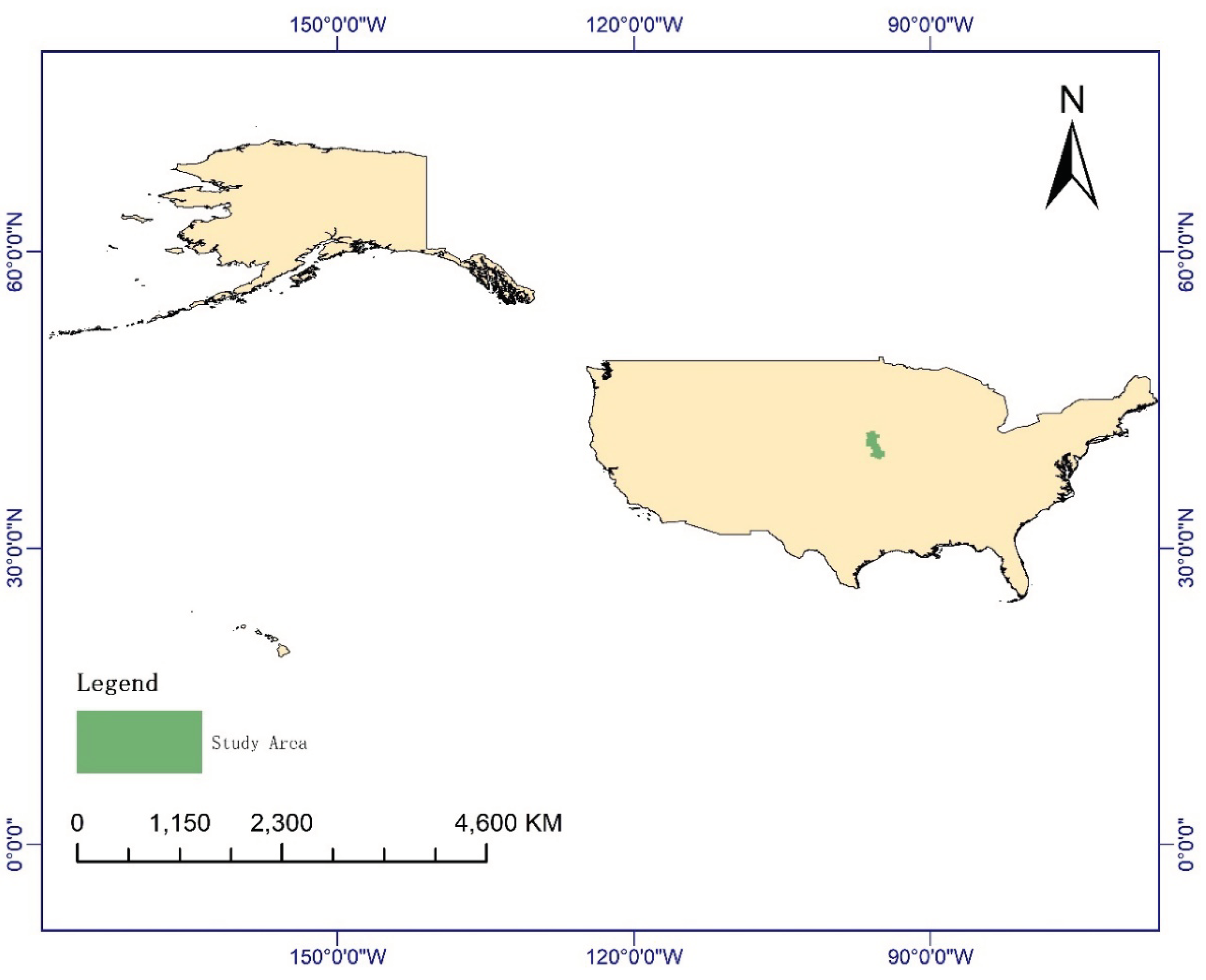
Figure 2.
Schematic representation of the changes in the NDVI in the study area after the disaster. (a) 19/03/2019; (b) 20/03/2019; (c) 21/03/2019; (d) 22/03/2019.
Figure 2.
Schematic representation of the changes in the NDVI in the study area after the disaster. (a) 19/03/2019; (b) 20/03/2019; (c) 21/03/2019; (d) 22/03/2019.
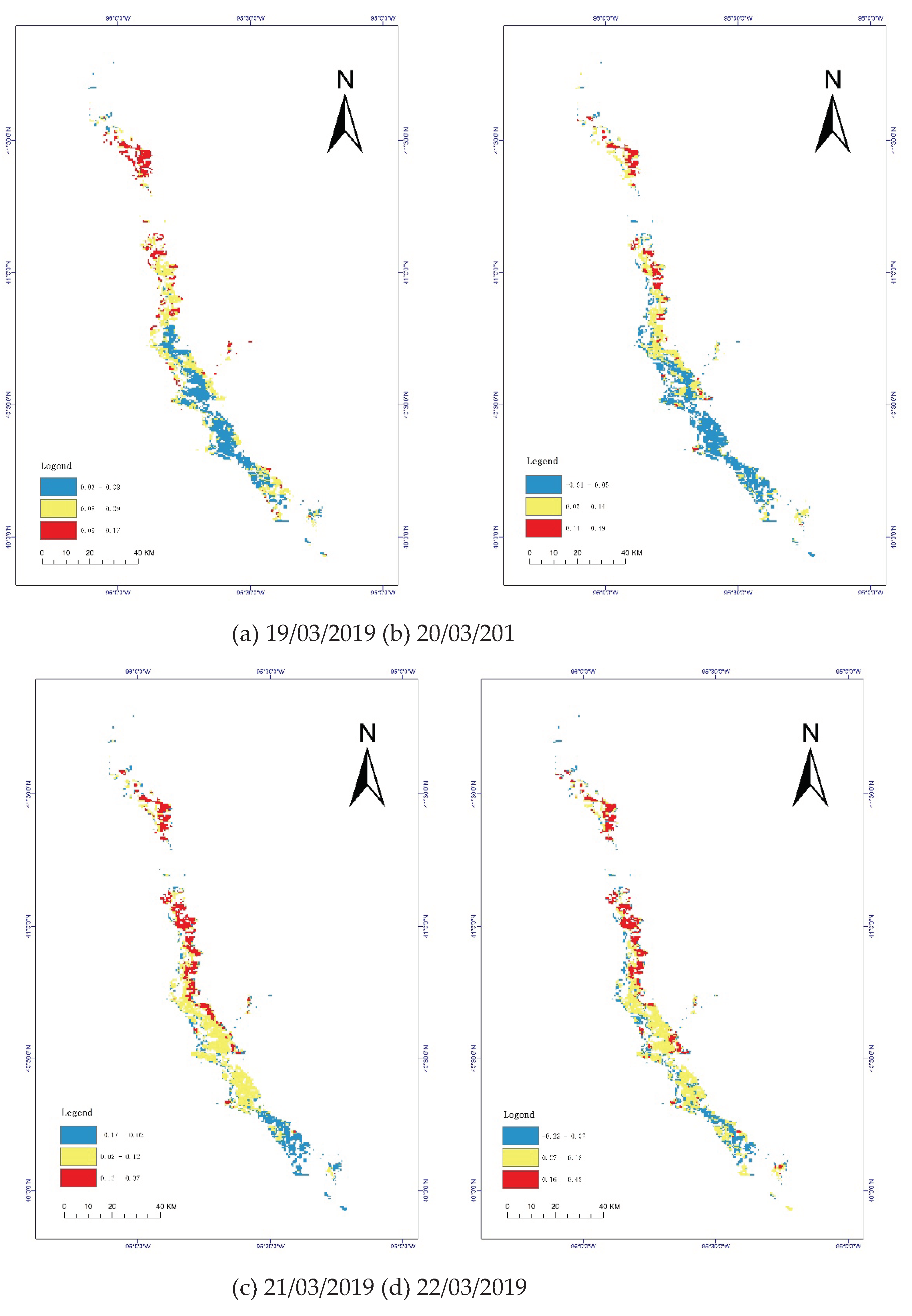
Figure 3.
Schematic of the elevation and slope of the study area. (a) DEM; (b) slope.
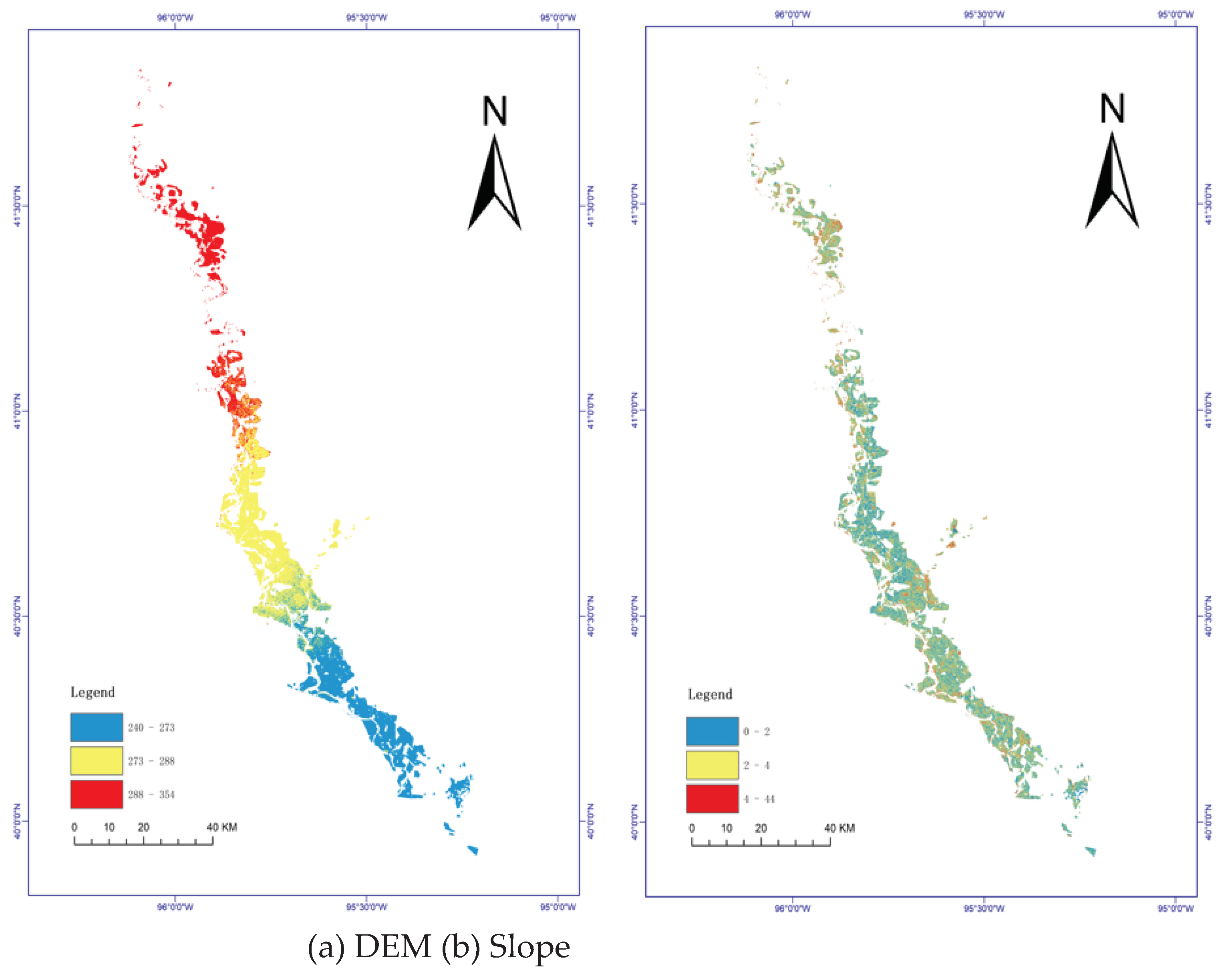
Figure 4.
Cumulative precipitation distribution in the study area.
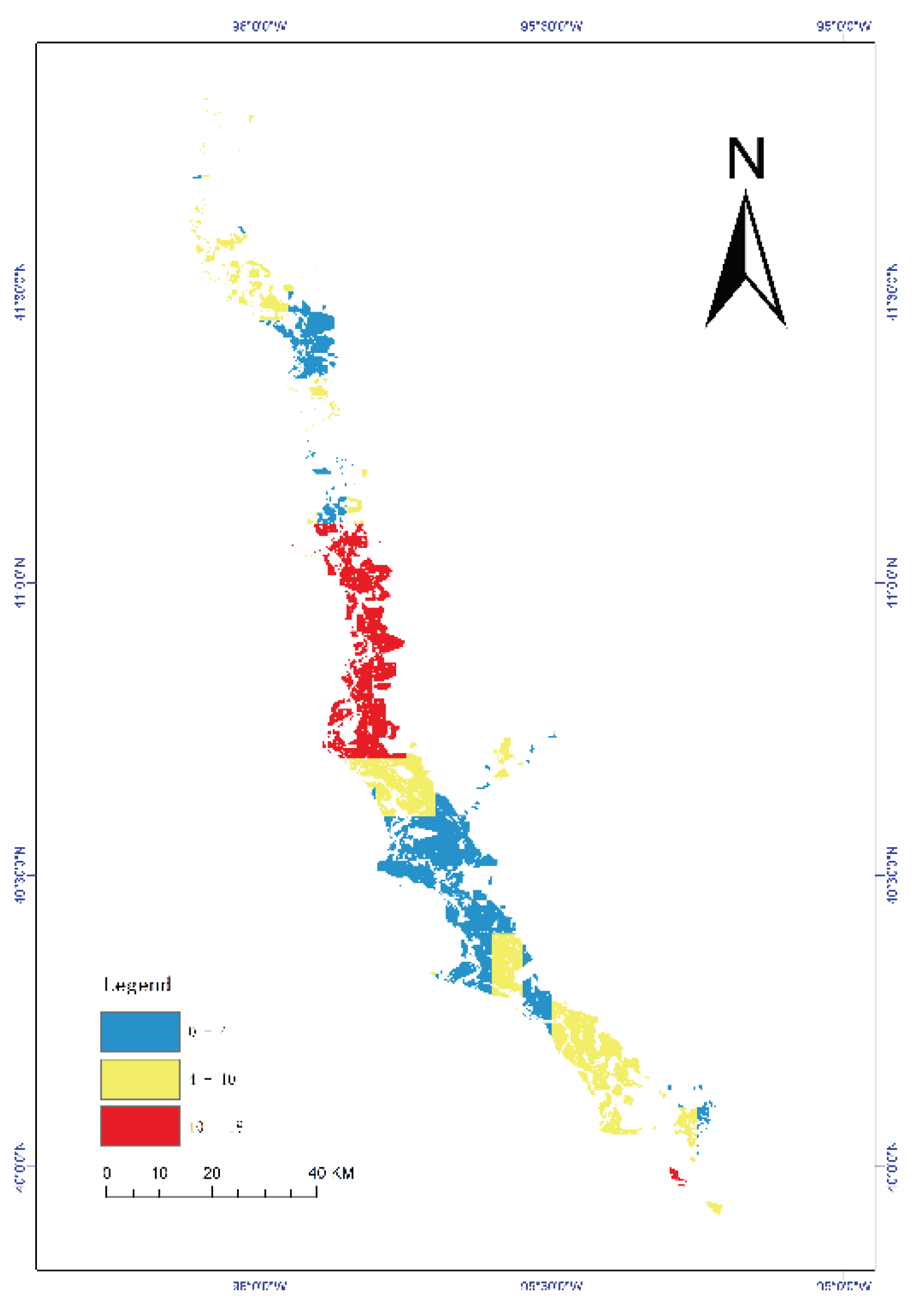
Figure 5.
Flowchart of showing the creation of the CFAI.
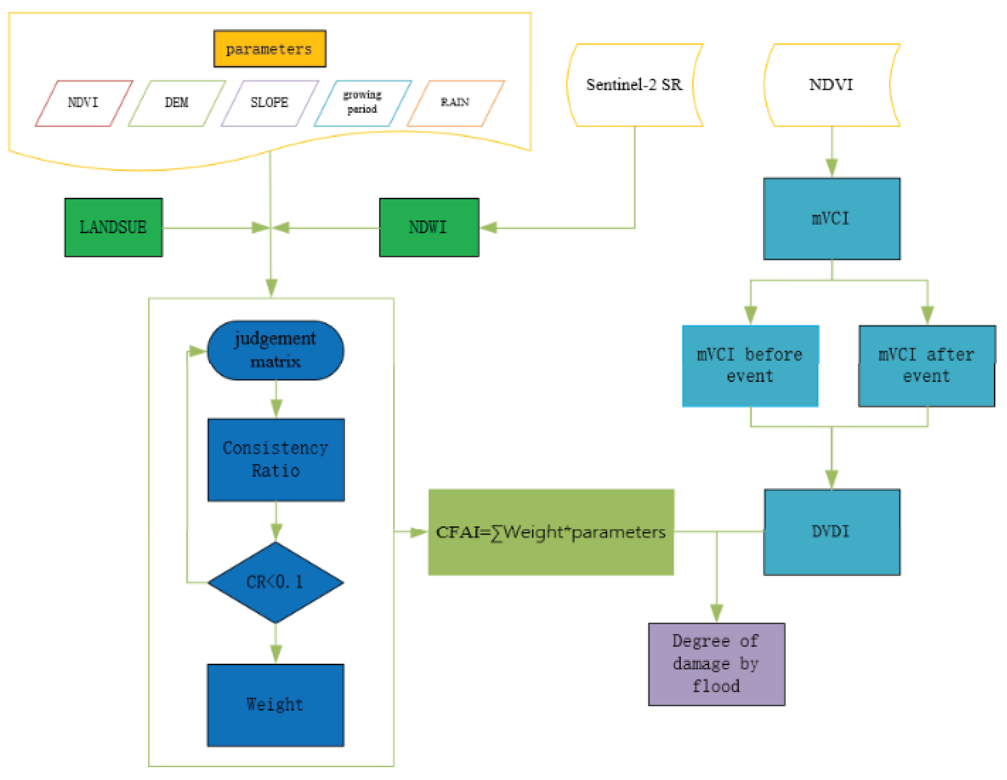
Figure 6.
Schematic diagram showing the extracted water bodies. (a) Extent of water bodies in 2018; (b) extent of water bodies in 2019; (c) extent of flood inundation.
Figure 6.
Schematic diagram showing the extracted water bodies. (a) Extent of water bodies in 2018; (b) extent of water bodies in 2019; (c) extent of flood inundation.
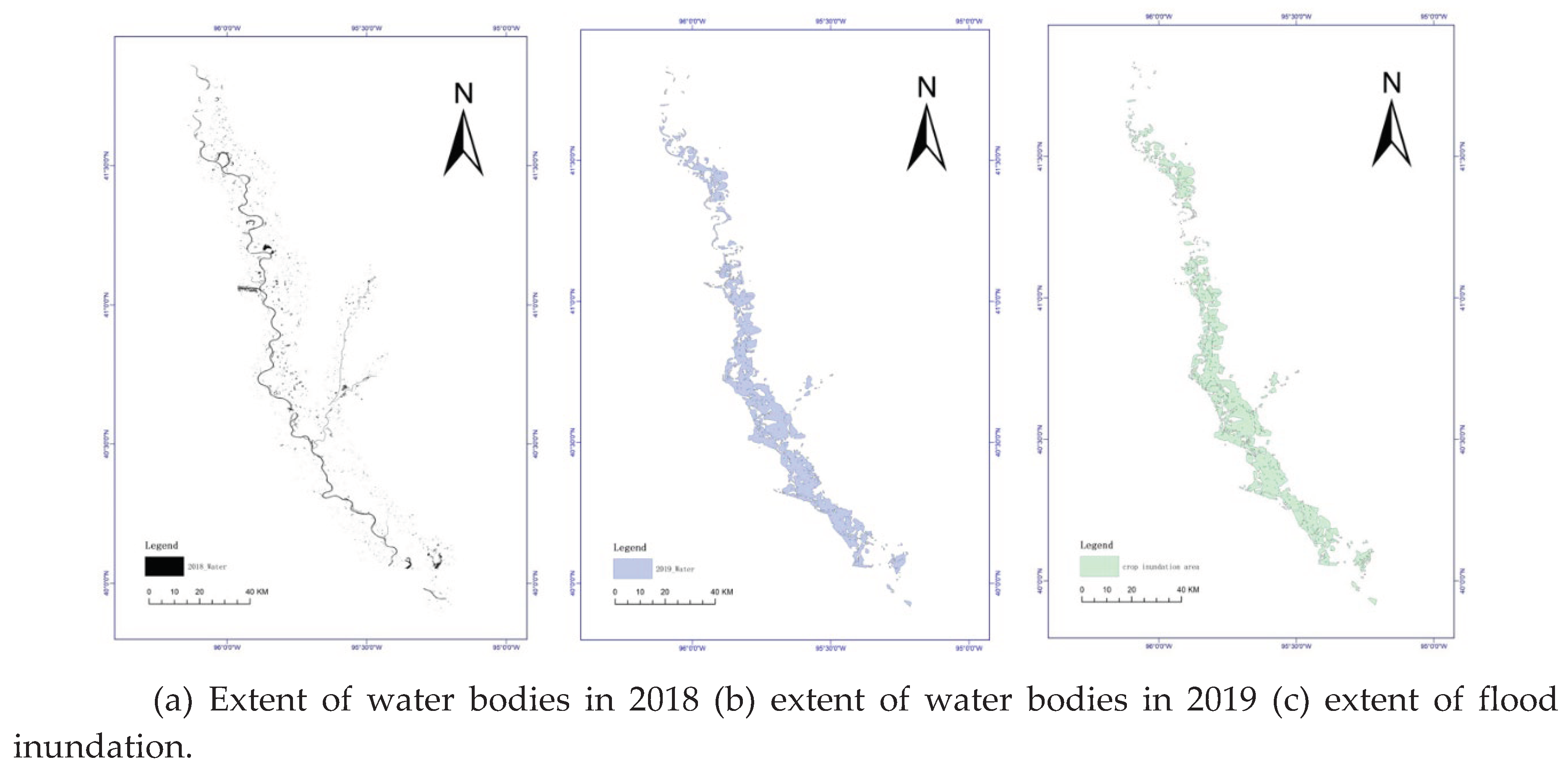
Figure 7.
Chronological assessment of flood impacts in the study area. (a) 19/03/2019; (b) 20/03/2019; (c) 21/03/2019; (d) 22/03/2019.
Figure 7.
Chronological assessment of flood impacts in the study area. (a) 19/03/2019; (b) 20/03/2019; (c) 21/03/2019; (d) 22/03/2019.
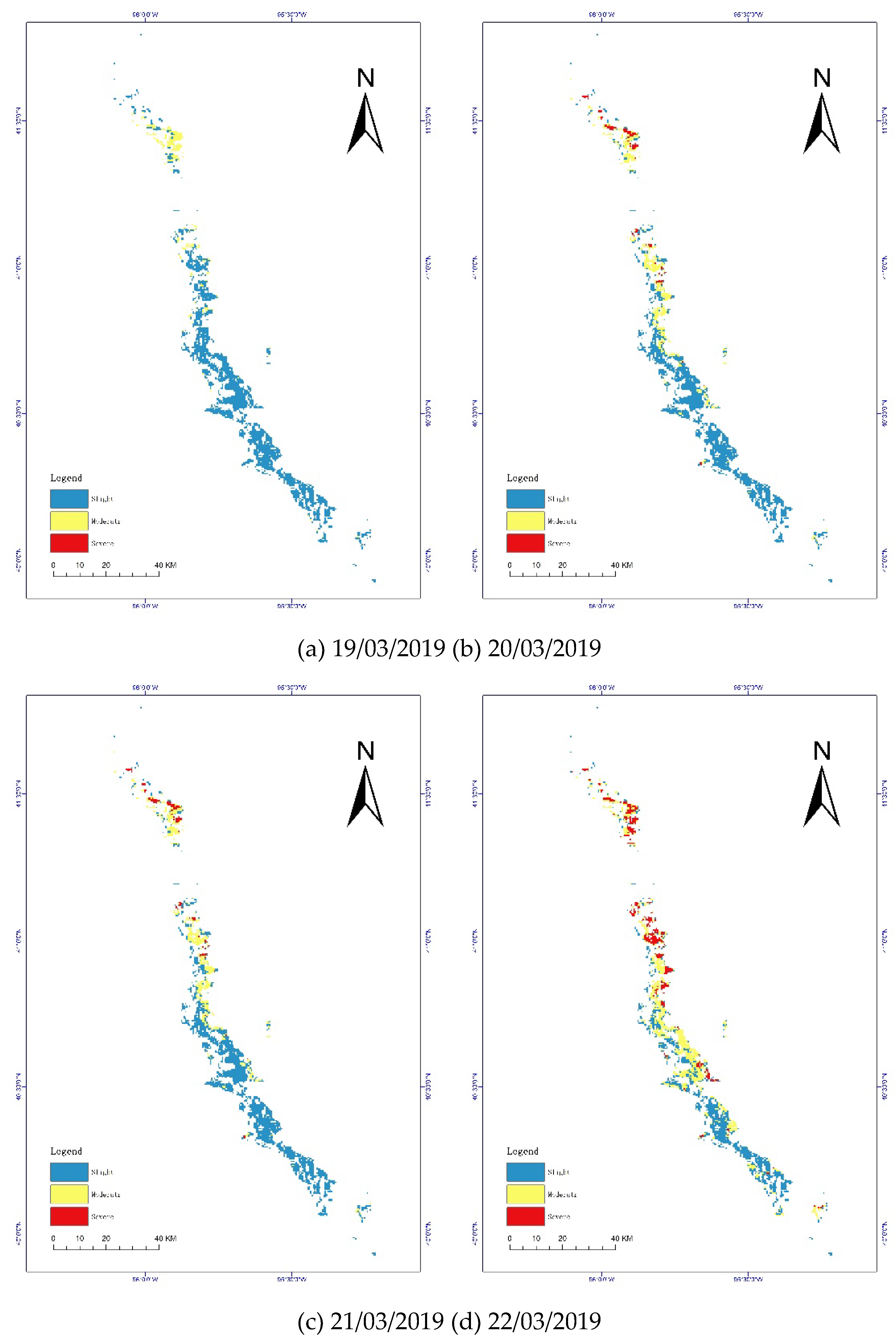
Figure 8.
Comparison of the results of the CFAI and DVDI assessments. a: CFAI. b: DVDI
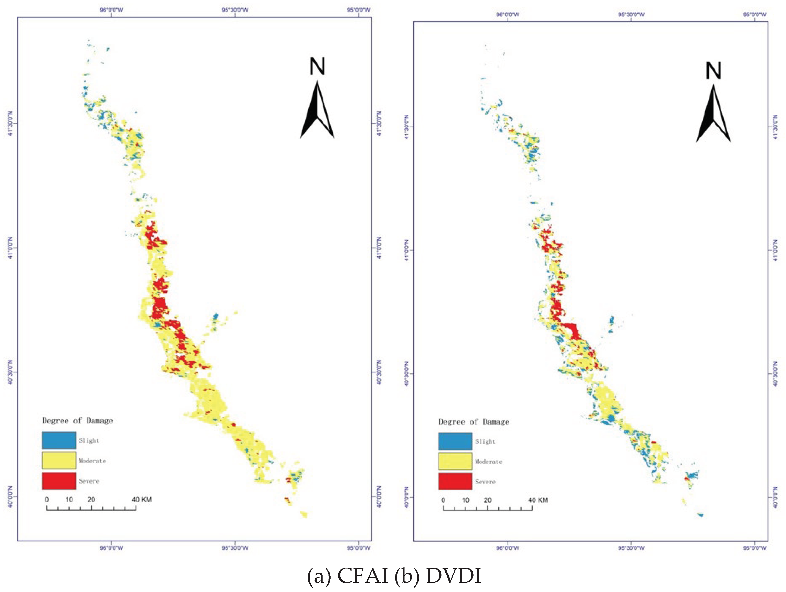

Table 1.
Results of grading and assignment values for each impact factor.
| Norm | Grading/score | ||
|---|---|---|---|
| Slight/1 | Moderate/3 | Severe/5 | |
| Change in NDVI | 0-0.1 | 0.1-0.2 | >0.3 |
| Cumulative precipitation/mm | 50-100 | 100-250 | >250 |
| Growing period | Green-up/Maturity | Grain filling/Heading | Jointing/Tillering |
| Relative elevation/m | >12 | 8-12 | 0-8 |
| Slope/degree | >15 | 5-15 | 0-5 |
Table 2.
Judgment matrix
| Norm | Change in NDVI | Relative elevation | Slope | Growing period | Cumulative precipitation |
|---|---|---|---|---|---|
| Change in NDVI | 1 | 4 | 4 | 5 | 6 |
| Relative elevation | 0.25 | 1 | 1 | 4 | 5 |
| Slope | 0.25 | 1 | 1 | 4 | 5 |
| Growing period | 0.2 | 0.25 | 0.25 | 1 | 3 |
| Cumulative precipitation | 0.167 | 0.2 | 0.2 | 0.333 | 1 |
Table 3.
Consistency test
| Consistency test results | ||||
|---|---|---|---|---|
| Largest characteristic root | CI value | RI value | CR value | Consistency test results |
| 5.329 | 0.082 | 1.11 | 0.074 | pass |
Table 4.
Indicator weights of crop damage impact factors
| AHP hierarchical analysis results | ||||
|---|---|---|---|---|
| Norm | Eigenvector | Weight (%) | Largest characteristic root | CI value |
| NDVI | 2.425 | 48.497 | 5.329 | 0.082 |
| Relative elevation | 0.973 | 19.462 | ||
| Slope | 0.973 | 19.462 | ||
| Growing period | 0.404 | 8.089 | ||
| Cumulative precipitation | 0.225 | 4.491 | ||
Table 5.
Impact levels of the CFAI and DVDI
| CAFI | DVDI | |
|---|---|---|
| Slight | 24.9% | 7.1% |
| Moderate | 61.7% | 77.4% |
| Severe | 13.4% | 15.5% |
Disclaimer/Publisher’s Note: The statements, opinions and data contained in all publications are solely those of the individual author(s) and contributor(s) and not of MDPI and/or the editor(s). MDPI and/or the editor(s) disclaim responsibility for any injury to people or property resulting from any ideas, methods, instructions or products referred to in the content. |
© 2024 by the authors. Licensee MDPI, Basel, Switzerland. This article is an open access article distributed under the terms and conditions of the Creative Commons Attribution (CC BY) license (http://creativecommons.org/licenses/by/4.0/).
Copyright: This open access article is published under a Creative Commons CC BY 4.0 license, which permit the free download, distribution, and reuse, provided that the author and preprint are cited in any reuse.


