
Submitted:
21 February 2024
Posted:
25 February 2024
You are already at the latest version
Abstract
.(1) Background: Groundwater resources management in dry lands, characterized by climate var-iability and population growth, is difficult. Exploration and exploitation of groundwater, due to inadequate surface water is very costly. The present study employed Analytic Hierarchy Process (AHP) and GIS to identify Ground-Water Potential (GWP) areas in a semi-arid region of Nigeria; (2) Methods: Land-use-land-cover, drainage density, slope, rainfall, static water level, soil media, vadose media and aquifer media were selected for GWP analysis. Parameters weights were de-termined using AHP and ranked based on their contribution to GWP by experts. The parameters were then integrated using weighted overlay tool in ArcGIS 10.5 to produce GWP map of the study area. Boreholes yield data from 245 wells were collected to determine the model accuracy and model validation; (3) Results: Results classified the study area into very high GWP (1.9%), high GWP (8.8%), moderate GWP (62%), low GWP (20.70%) and very low GWP (6.6%). Validation of the AHP model with boreholes yield data shows a correlation coefficient of 71.3% giving a good prediction; (4) Conclusions: AHP and GIS can be used to successfully map GWP areas which could serve as an exploration guide for sustainable management of groundwater resources in semi-arid areas.
Keywords:
groundwater exploration
; AHP
; GIS
; semi-arid environment
; Kano
; Nigeria
1. Introduction
Socio-economic activities, sustainability and well-being of human population rely on freshwater supply [1]. Scarcity of surface water sources, together with a decline in quality and quantity of such resources in arid and semi-arid environments intensified reliance on groundwater for domestic and agricultural use [2]. There is also the problem of surface water pollution due to anthropogenic activities and lack of wastewater treatment [3]. In sub-Saharan Africa, the increasing level of freshwater demand due to the ever-growing population necessitates more attention on groundwater sources in many communities [4,5]. Ground-based geophysical surveys give precise information on the groundwater potential (GWP) of an area, but the method is expensive and time consuming for a large area. This calls for a cost-effective multi-criteria decision-making approach in conjunction with remote sensing technology and geographic information system (GIS) for identification of potential groundwater resources areas that could pave the way for an effective and sustainable groundwater exploration and exploitation initiatives [6]. Groundwater occurrence and distribution in a geographical location depends on the anthropogenic, physiographic and climatic factors affecting hydrological conditions of the area. Analyzing relationship and overall influence of such factors on groundwater availability is essential for effective prediction of GWP of an area [7].
In their quest for a suitable prediction methodology of potential groundwater areas through modeling the effects of physiographic variables on hydrologic parameters to achieve sustainable groundwater management, hydrogeologists found the method of analytic hierarchy process (AHP) as one of the multi-criteria decision analyses models useful for effective groundwater management [8,9]. The method provide a means for dealing with complex spatial decision problem by decomposing the spatial decision problem into a hierarchy of sub problems for easy comprehension and subjective evaluation [10].
Nithya et al. [11] studied the influence of geology, lineaments, geomorphology, slope, drainage density, soil and rainfall on GWP of Chittar basin India, using GIS based AHP. Results was validated using groundwater yield of 24 open wells. The GWP map classified the areas into very good, good, medium, poor and very poor GWP. Ifediegwu [12] used integrated RS, GIS and AHP to study the influence of eight thematic maps (geology, rainfall, geomorphology, slope, drainage density, soil, land use land cover (LULC) and lineament density) on GWP in Lafia, Nigeria. Validation was done using data from 50 boreholes. Results classified 19.3, 12.9, 57.8, and 10% of the study area in to good, moderate, poor, and very poor GWP areas. Kamaraj et al. [13] integrated remote sensing and GIS to determine the effect of 15 parameters (ie: geology, geomorphology, lineament density, topsoil resistivity and thickness, weathered zone resistivity and thickness, first fractured resistivity and thickness, second fractured resistivity and thickness, slope, LULC, drainage density and rainfall) on GWP of Mettur taluk, Salem district and Tamil Nadu, India. Result showed that top soil thickness, pediment, lithology, slope type and rainfall as the predominant factors influencing groundwater potential. Ally et al. [14] combined seven thematic map layers of lithology, soil types, lineament, magnetic intensity, slope, drainage density and elevation to develop GWP zone map of Mpwapwa District, Tanzania. The resulting GWP zone was validated using area under the curve and overlaying method. It was shown that 19% of the area was classified as very good, 31% as good, 28% as moderate, 22% as poor and 2% as very poor GWP zones.
Researches have also been carried out to compare AHP with other approaches. Razandi et al. [15] compared the use of AHP, frequency ratio and certainty factor to map GWP of Varamin Plain, Tehran Iran. Receiver operating characteristics was used to determine the accuracy of the GWP maps and results indicated that the frequency ratio out performed both the AHP and certainty factor methods. Kaur et al. [16] used remote sensing and GIS to compare AHP with Catastrophe theory for demarcation of GWP zones of Panipat district, India. Results showed that the percentage of area covered by each model is almost the same thus the two models can be used for delineation of GWP areas. Shekar and Mathew [17] combined slope, drainage density, rainfall, geomorphology, LULC, curvature, soil, topographic wetness index, distance from the river, and elevation as thematic layers and used AHP and fuzzy-AHP in GIS environment to assess GWP zones in Murredu river basin, India. The zones were classified as poor, moderate and good GWP areas
AHP has been used, in GIS environment, by many scholars in prediction of GWP areas to explore groundwater resources [18,19,20,21,22]. The approach is proved to be a reliable means of facilitating, interpreting, analyzing large volume of diverse dataset which are then modeled through analytic procedure to produce useful information for use by authorities concerned [23]. For this purpose, the present study employed AHP, using remote sensing and GIS, to integrate hydro-geological and climatic data to assess and map GWP areas which could serve as an exploration/exploitation guide for efficient and sustainable management of groundwater resources in Kano state, Nigeria. Little. The use of AHP in combination with remote sensing and GIS is novel in this part of the world as information is scarce in sub-Saharan Africa. The research will provide policy makers on the best way to sustainably manage the groundwater in the area.
2. Materials and Methods
2.1. Study Area
The study area is in Northern part of Nigeria, West Africa. The area lies between latitudes 100 23′ 40″ and 120 34′24″ North, longitudes70 41′ 15″ and 90 21′ 21″ East (Figure 1). The total areal coverage of the state is estimated at 20,131 km2 with about two-third of the area belonging to crystalline basement rocks and the remaining one-third is sedimentary formation [24]. Mean annual rainfall is 635 mm in the north and 1000 mm in the south and occurs between May and October [25]. Kano state is the most populous state in Nigeria with a population density of 764/km2. The 2023 population of the state is about 15,462,200 people with an annual growth rate is 3.2% [26]. During the 2010 – 2013 period, there was a steady annual decrease of groundwater level and groundwater beneath the floodplains dropped from 9000 MCM to 5000 MCM from 1964 to 1987 in the Chad Formation area of the region [27]. Surface water is not readily available and this puts more pressure on groundwater. There is an indiscriminate drilling of boreholes in the state and this results in the decline of water table as more boreholes and wells dry up. This underscores the need to have an assessment for the groundwater with a view to sustainably mange it.
2.2. Data Collction
The administrative boundary map, in shape file format, downloaded from DIVA-GIS (http://www.divagis.com), was employed for the generation of study areal extent. Satellite imagery of LandSat 8 OLI and Shuttle Radar Topographical Mission Digital Elevation Model (SRTM DEM) both having 30 m spatial resolution were obtained from United States Geological Survey site (www.glovis.usgs.com). Two hundred and fourty five (245) set of boreholes log data spread across the study area, obtained from the archives of Kano Agricultural and Rural Development Authority (KNARDA), were used to generate hydro-geological profile. The boreholes were ranked according to their yield in the order W1 to W245 with W1 having the least yield and W245 the highest. Also, rainfall data of 9 meteorological stations was obtained from Kano State Water Board.
2.3. Data Processing
The methodology adopted in this research includes the following stages as shown in Figure 2. For the remotely sensed data, the administrative boundary data was processed in ArcGIS environment to mask down Kano State the study area as shown in Figure 1. Landsat 8 OLI was clipped to the study area and ERDAS 9.0 were applied for the satellite image processing. Land-use-land-cover (LULC) was interpreted using visual interpretation technique and supervised classification of maximum likelihood classification was carried out for final LULC map. For this study slope steepness and stream network information were deduced from SRTM DEM having 30m spatial resolution while the stream network information was consecutively processed to produce flow direction information for the surface drainage, flow accumulation information, stream order information and finally, generating drainage density map for the study area.
Rainfall distribution map of the area under study was produced from the rainfall data of nine meteorological stations across the study area ie (Challawa, Karaye, Gajale, Riruwai, Wudil, Ranka, Joda, Wak and BUK) using inverse distance weighting (IDW) interpolation method. While available information on static water level, soil media, vadose media and aquifer media, obtained from the KNARDA, was used to produce the static water level, soil media, vadose media and aquifer media maps of the study area respectively.
2.4. Analytic Hierarchy Process (AHP)
The AHP is a multi-criteria decision-making process involving experts ranking on the relative importance of some chosen parameters. The steps involved are as follows:
Step 1: This step involves identification of thematic layers. In this work, eight thematic layers of LULC, drainage density, slope, rainfall, static water level, soil media, vadose media and aquifer media were chosen
Step 2: The experts’ opinion was used to generate pairwise comparison matrix (Table 1) based on their relative importance using Saaty’s scale. Maps of the parameters were classified on a uniform rank of 1 – 5, where a scale of 1 denotes very low, 2 low, 3 implies moderate, 4 represents high and 5 denotes very high GWP [4,28].
Step 3: Computations of the normalized weights utilizing the criteria’s geometric mean (Gm) as shown in Equation 1. The normalized weights are presented in Table 2
where Wn = Eigen vector of the matrix
Step 4: The principal eigen value and Consistency Index (CI) were calculated in order to capture the uncertainty in experts’ judgements using following Equation 2
where = largest eigenvalue from the pairwise comparison matrix, n = number of classes. The consistency of the pairwise comparison matrix was measured using Consistency Ratio (CR) given by Equation 3
where RI = random consistency index = 1.41 when n = 8 [29].
Step 5: The resulting thematic maps of LULC, drainage density, slope, rainfall, static water level, soil media, vadose media and aquifer media were integrated according to Equation 4 using weighted overlay method in ArcGIS 10.5 to generate an index value signifying level of GWP per each cell.
where GWPI = the GWP index, Wi = the determined weight of each thematic layer. Xi = the ranks for the classes within each thematic layer.
Finally, the prediction accuracy of the model was determined and the proposed GWP map was validated with recorded borehole yield data using Pearson correlation coefficient to serve as easy guide for assessment of groundwater availability within the study area (Equation 5).
where xi is the respective borehole yield value at a particular point, yi is the GWP index value at that point.
3. Results
3.1. LULC
LULC of an area control hydrological processes of evapotranspiration, infiltration and surface runoff, which largely governed the occurrence and distribution of groundwater resources [30]. The LULC map of the study area (Figure 3) shows vegetation and agricultural area covered an area of about 19194km2 (95.34%) and water body accounted for 317 km2 (1.58%). These dominant land uses promote infiltration which lead to high groundwater prospect. The built-up areas and bare ground occupy only 587 km2 (2.92%) and 33 km2 (0.17%).
3.2. Drainage Density
Drainage density of an area defines the sum of the drainage channel lengths per unit area. Drainage basins having high drainage density results in low infiltration within its subsurface formation and hence, low groundwater prospect [31]. In the study area, the high and very high drainage density areas constitute 10390 km2 (51.60%), moderate 7828 km2 (38.90%) while low and very low drainage density covered only 1913 km2 (9.50%) of the study area (Figure 4). This low to very low drainage density zones implies high infiltration and recharge potentials which is a function of high groundwater prospect [4].
3.3. Slope
Slope is an aspect of geomorphologic features. Its nature along with other geomorphic features play a significant role in determining infiltration and potential groundwater recharge in an area.. Slope of study area as illustrated in Figure 5 revealed that about 18007 km2 (89.50%) of the area is covered by a slope of less than 50 signifying a nearly level and gentle surface which give high infiltration rate and high probability of groundwater prospect. 879 km2 (9.30%) covered by (5 - 8)0 moderately sloping, 195 km2 (0.95%) covered by (9 - 20)0 slightly steep sloping while 50 km2 (0.25%) of the area is covered by greater than 200 steep sloping leading to less rainfall/run off infiltration and less probability of groundwater prospect [32].
3.4. Rainfall
Rainfall as a meteorological factor that contributes immensely to groundwater recharge. Understanding the nature and characteristics of rainfall of an area helps in predicting its effects on evapotranspiration, infiltration and surface runoff. For hydrological analysis, areal distribution of rainfall is required so as to create potential groundwater areas [19]. The distribution of rainfall in the study area ranges from 629mm to 1510mm suggesting a seasonally arid climate with a mean annual rainfall decreasing towards the north [33]. The rainfall map (Figure 6) reveals that about 1043 km2 (5.18%) received high amount of rainfall which signifies good GWP, 276 km2 (1.37%) moderate, while 18812 km2 (93.45%) received low amount of rainfall suggesting poor GWP.
3.5. Static Water Level
Static water level is a measure of the distance from the ground surface to the water level and a parameter that determine the potential distance for water to travel to the aquifer. Variation in static water level within the study area shows a change ranging from 1.4–9.6 m covering 6358 km2 (31.6%), as very high, 9.7-18 m covering 9103 km2 (45.2%) as high, 19 - 26 m covering 4187 km2 (20.8%) as ‘Moderate, while 27 - 34 m covering 463.0 km2 (2.30%) and 35 - 43 m covering 20.00 km2 (0.10%) as low and very low groundwater prospective areas (Figure 7)
3.6. Soil Media
Soil media is an influencing factor that facilitates infiltration of rainfall and represent surface feature that controls the amount of recharge into the saturated zone. The soil types in Figure 8 include sand, sandy loam and peat covering 3866 km2 (19.18%) which allow water to infiltrate easily due to high permeability suggesting high groundwater prospect area, loamy soil covers an area of 8968 km2 (44.6%) and non-aggregated clay, clay loam and silt covered 7297 km2 (36.22%) which imply limited infiltration because of low permeability and hence, low groundwater prospect [19].
3.7. Vadose Media
The unsaturated zone of the study area (Figure 9) is underlain by basement complex rocks and sedimentary formation. Only 824 km2 (4.1%) of the study area is covered by sandstone which allows high infiltration due to its high porosity hence, suggesting high groundwater availability. Metamorphic/igneous and shale formations covered 12597 km2 (62.6%) giving moderate infiltration and silt/clay covered 6710 km2 (33.3%) allowing low infiltration suggesting low probability of groundwater prospect [20].
3.8. Aquifer Media
Aquifer media properties control the rate at which groundwater flow within an aquifer formation. Figure 10 shows the major aquifer formation in the study area with thin bedded sand and sand/gravel occupying 2189 km2 (11%) and 613 km2 (3%) suggesting high groundwater prospects. The metamorphic/igneous and weathered rocks occupies 5647 km2 (28%) and 11682 km2 (58%) suggesting moderate GWP.
3.9. GWP Map
The GWP map in Figure 11 was generated according to Equation 4 by weighted overlay analysis of the determined weights of each of the groundwater controlling parameters and assigned ranks for the sub class of each parameter Table 3. The GWP map was classified into five as very low covering1320 km2 (6.60%), low 4164 km2 (20.70%), moderate 12482 km2 (62.0%), high 1783 km2 (8.80%) and very high covering 382 km2 (1.90%) of the study area (Figure 11).
3.10. Model Accuracy
The classified boreholes yield data in Table 4 were super imposed on GWP map obtained using the RS-GIS and AHP. The results show that out of 80 boreholes with (ID No W1 to W80) classified as low yielding wells (yield < 50 l/min), 67 fall within very low to low GWP categories representing 83.8% accuracy. Out of the 129 wells with (ID No W81 to W209) classified as moderate yielding wells (with yield between 50 l/min to 100 l/min), 82 fall within the moderate GWP category representing 63.6% and likewise, out of the 36 wells with (ID No W210 to W245) classified as high yielding wells (with yield > 100 l/min), 28 fall within the high and very high GWP representing 77.8% accuracy. The overall accuracy is thus 74.4 percent (Figure 11). With good correlation coefficient of 71.3 % and prediction accuracy of 74.4%, it is evident that AHP can be used to predict the GWP of areas as surrogate measure for boreholes yield.
3.11. Model Validation
Validation is the most important process of model without which models lack scientific significance [34]. For validation, the Pearson Correlation Coefficient was employed to compare the recorded boreholes yield data with the GWP index value obtained by AHP model. The plot assessment shows a correlation coefficient of 0.713 which indicates a good prediction (Figure 12).
4. Discussion
Globally, the problem of stress on fresh water supply is a well-documented issue. This problem is exacerbated by climate change which manifest itself in drought in some parts of the world. Highly populated areas, such as Kano, become more vulnerable arising from the over-abstraction of water sources due to high water demand from the high population of about 15,462,200 persons [26]. Surface water pollution and grossly insufficient municipal water supply has led to the demand for groundwater in the state [2,27]. The United Nations Sustainable Development Goal No. 6 attempts to address this issue and Nigeria is not on track to achieving this by 2030 as only 29% of the population use safely managed drinking water sources [35]. Other targets related to SDG No. 6 are also below 50% which is far from the expectations. The country has to fast-track the implementation of policies to achieve this aim.
The geology of Kano State is crystalline basement complex rock in two-third of the basin and the remaining is sedimentary formation. There is a sharp decline in groundwater level which calls for researches towards sustainability of groundwater. AHP was integrated in to RS and GIS to delineate and map GWP areas. Eight thematic layers affecting groundwater recharge potential including LULC, drainage density, slope, rainfall, static water level, soil media, vadose media and aquifer media were chosen in this research. Results of spatial analysis show that better groundwater prospective areas occupied total area of 2165 km2 (10.70%) and mostly situated in Gurun, Dugol, Zago, Kumbo in the north and Dukku, Doguwa, Riruwai, Dambazau in the southern parts of Kano State (Figure 11). These are mainly attributed to the nature of the topography, drainage density, rainfall and these areas could be suitable for groundwater development for agricultural utilization. Moderate GWP areas are widely distributed across the study area and covered 12482 km2 (62%) of the state and could be suitable for groundwater development for domestic use. Meanwhile poor GWP areas covered 5484 km2 (27.30%) and concentrated mostly in areas having high drainage density and low rainfall at central and southeastern parts of Kano state. These poor GWP areas could not be sufficient for groundwater development for commercial agriculture and hence the need for surface water infrastructure to augment the existing water supply system. For sustainability, efforts should be stepped-up to improve water supply, using surface water sources, in areas close to existing surface waters. This will go a long way in relieving the current pressure on groundwater.
5. Conclusions
Identification of GWP areas in arid environment of Kano, Nigeria was achieved through the use of expert based multi criteria evaluation approach of AHP in GIS environment. The results shows rainfall (23.9%) and slope (19.4%) as the most important factors contributing to GWP while land use land cover (4.99%) and soil media (5.03%) exerts least significant impact. However, the developed model categorized the study area into very low 1320 km2 (6.60%), low 4164 km2 (20.70%), moderate 12482 km2 (62.0%), high 1783 km2 (8.80%) and very high 382 km2 (1.90%) groundwater prospective areas. Consequently, the AHP model was validated with recorded boreholes yield data to achieve a correlation coefficient of 71.3% and prediction accuracy of 73.5%. With fairly good model validation results its evident that geospatial technology of RS-GIS and AHP technique can be employed to successfully mapped groundwater prospective areas which could serve as an exploration/exploitation guide for efficient and sustainable management of groundwater. In addition, for long term sustainability of water resources in study area an updated RS- GIS and AHP using adequate inventory data is recommended as well as development of more surface water infrastructure in poor GWP areas to curtail the prevailing groundwater development in Kano state, Nigeria.
Author Contributions
“Conceptualization, A.A.S. and S.D.; methodology, A.A.S; software, S.I.A.; validation, S.D and A.A; formal analysis, A.A.; investigation, A.A.S..; resources, A.A.; data curation, A.A.S.; writing—original draft preparation, A.A.S.; writing—review and editing, S.D. and S.I.A.; supervision, S.D.; project administration, A.A. and S.D.; funding acquisition, A.A. All authors have read and agreed to the published version of the manuscript.”
Funding
This research received no external funding.
Institutional Review Board Statement
Not applicable.
Data Availability Statement
The data presented in this study are available on request from the corresponding author. However, the data is not publicly available due to constraints.
Acknowledgments
This study is supported via funding from Prince Sattam bin Abdulaziz University project number (PSAU/2024/R/1445).
Conflicts of Interest
The authors declare no conflicts of interest.
References
- Griggs, D., Stafford-Smith, M., Gaffney, O., Rockström, J., Öhman, M.C., Shyamsundar, P., Steffen, W., et al. Policy: Sustainable development goals for people and planet, Nature, 2013, 495(7441), p. 305. [CrossRef]
- Akujieze, C.N., Coker, S. and Oteze, G., Groundwater in Nigeria–a millennium experience–distribution, practice, problems and solutions, Hydrogeology Journal, 2003, 11(2), pp. 259–274. [CrossRef]
- Dan’azumi, S. and Bichi, M.H. Industrial pollution and implication on source of water supply in Kano, Nigeria, Intern. J. of Engineering & Technology, 2010, 10(1), pp. 101–109.
- Roy, S., Hazra, S., Chanda, A. and Das, S. Assessment of groundwater potential zones using multi-criteria decision-making technique: a micro-level case study from red and lateritic zone (RLZ) of West Bengal, India, Sustainable Water Resources Management, 2020, 6(1), pp. 1–14. [CrossRef]
- Tarhule, A. Status of Groundwater Use, Exploration, and Policy, in Nigeria, National Groundwater Association Summit, 2007, Abuja, Nigeria.
- Abdullateef, L., Tijani, M.N., Nuru, N.A., John, S. and Mustapha, A. Assessment of groundwater recharge potential in a typical geological transition zone in Bauchi, NE-Nigeria using remote sensing/GIS and MCDA approaches, Heliyon, 2021, 7(4), p. e06762. [CrossRef]
- Rahmati, O., Samani, A.N., Mahdavi, M., Pourghasemi, H.R. and Zeinivand, H. Groundwater potential mapping at Kurdistan region of Iran using analytic hierarchy process and GIS, Arabian Journal of Geosciences, 2015, 8(9), pp. 7059–7071. [CrossRef]
- Jha, M.K., Chowdary, V.M. and Chowdhury, A. Groundwater assessment in Salboni Block, West Bengal (India) using remote sensing, geographical information system and multi-criteria decision analysis techniques, Hydrogeology Journal, 2010, 18(7), pp. 1713–1728. [CrossRef]
- Madrucci, V., Taioli, F. and de Araújo, C.C. Groundwater favorability map using GIS multicriteria data analysis on crystalline terrain, Sao Paulo State, Brazil, Journal of Hydrology, 2008, 357(3–4), pp. 153–173. [CrossRef]
- Cabrera, J.S. and Lee, H.S. Flood-prone area assessment using GIS-based multi-criteria analysis: a case study in Davao Oriental, Philippines”, Water, 2019, 11(11), p. 2203. [CrossRef]
- Nithya, C.N., Srinivas, Y, Magesh, Kaliraj, N.S. Assessment of groundwater potential zones in Chittar basin, Southern India using GIS based AHP technique, Remote Sensing Applications: Society and Environment, 2019, 15, 100248. [CrossRef]
- Ifediegwu, S.I., Nnebedum, D.O. and Nwatarali, A.N. Identification of groundwater potential zones in the hard and soft rock terrains of Kogi State, North Central Nigeria: an integrated GIS and remote sensing techniques, SN Applied Sciences, 2019, 1(10), pp. 1–15. [CrossRef]
- Kamaraj, P; Jothimani, M; Panda, B; Sabarathinam, C. Mapping of groundwater potential zones by integrating remote sensing, geophysics, GIS, and AHP in a hard rock terrain, Urban Climate, 2023, 51, 101610. [CrossRef]
- Ally, MA; Yan, J; Bennett, G; Lyimo, N.N; Mayunga, S.D. Assessment of groundwater potential zones using remote sensing and GIS-based fuzzy analytical hierarchy process (F-AHP) in Mpwapwa District, Dodoma, Tanzania, Geosystems and Geoenvironment, 2024, 3(1), 100232, ISSN 2772-8838. [CrossRef]
- Razandi, Y., Pourghasemi, H.R., Neisani, N.S. et al. Application of analytical hierarchy process, frequency ratio, and certainty factor models for groundwater potential mapping using GIS. Earth Sci Inform 2015, 8, 867–883. [CrossRef]
- Kaur, L.; Rishi, M.S.; Singh, G.; Thakur, S.N. Groundwater potential assessment of an alluvial aquifer in Yamuna sub-basin (Panipat region) using remote sensing and GIS techniques in conjunction with analytical hierarchy process (AHP) and catastrophe theory (CT). Ecol Indic, 2019, 110, 105850. [CrossRef]
- Shekar, P.R; Mathew, A. Assessing groundwater potential zones and artificial recharge sites in the monsoon-fed Murredu river basin, India: An integrated approach using GIS, AHP, and Fuzzy-AHP, Groundwater for Sustainable Development, 2023, 23, 100994. [CrossRef]
- Aluko, O.E. and Igwe, O. An integrated geomatics approach to groundwater potential delineation in the Akoko-Edo Area, Nigeria, Environmental Earth Sciences, 2017, 76(6), p. 240. [CrossRef]
- Fashae, O.A., Tijani, M.N., Talabi, A.O. and Adedeji, O.I. Delineation of groundwater potential zones in the crystalline basement terrain of SW-Nigeria: an integrated GIS and remote sensing approach, Applied Water Science, (2014), 4(1), pp. 19–38. [CrossRef]
- Ifediegwu, S. I. Assessment of groundwater potential zones using GIS and AHP techniques: a case study of the Lafia district, Nasarawa State, Nigeria. Applied Water Science, 2022, 12(1). [CrossRef]
- Igwe, O., Ifediegwu, S.I. and Onwuka, O.S. Determining the occurrence of potential groundwater zones using integrated hydro-geomorphic parameters, GIS and remote sensing in Enugu State, Southeastern, Nigeria”, Sustainable Water Resources Management, 2020, 6, pp. 1–14. [CrossRef]
- Pinto, D., Shrestha, S., Babel, M.S. and Ninsawat, S. Delineation of groundwater potential zones in the Comoro watershed, Timor Leste using GIS, remote sensing and analytic hierarchy process (AHP) technique, Applied Water Science, 2017, 7(1), pp. 503–519. [CrossRef]
- Guru, B., Seshan, K. and Bera, S. (2017), Frequency ratio model for groundwater potential mapping and its sustainable management in cold desert, India, Journal of King Saud University-Science, 2017, 29(3), pp. 333–347. [CrossRef]
- Bala, A.E., Eduvie, O.M. and Byami, J. Borehole depth and regolith aquifer hydraulic characteristics of bedrock types in Kano area, Northern Nigeria, African J. of Env. Science and Tech, 2011, 5(3), pp. 228–237.
- Hamza, S.M., Ahsan, A., Imteaz, M.A., Ghazali, A.H. and Mohammed, T.A. GIS-based FRASTIC model for pollution vulnerability assessment of fractured-rock aquifer systems, Environmental Earth Sciences, 2017, 76(5), p. 197. [CrossRef]
- NPC (National Population Commission). Report on the population of Kano, 2023, Nigerian Population Commission Report. https://citypopulation.de/en/nigeria/admin/NGA020__kano/.
- Tukur, A I; Nabegu, AB; Umar, DA; Olofin, EA (2018) Sulaiman, WNA. Hydrology, 2018, 5(1). [CrossRef]
- Mukherjee, P., Singh, C.K. and Mukherjee, S. Delineation of groundwater potential zones in arid region of India—a remote sensing and GIS approach”, Water Resources Management, 2012, 26(9), pp. 2643–2672. [CrossRef]
- Saaty TL The analytic hierarchy process. McGraw-Hill, New York, 1980.
- Kaliraj, S., Chandrasekar, N. and Magesh, N.S. (2014), “Identification of potential groundwater recharge zones in Vaigai upper basin, Tamil Nadu, using GIS-based analytical hierarchical process (AHP) technique”, Arabian Journal of Geosciences, 2014, 7(4), pp. 1385–1401. [CrossRef]
- Singh, A., Panda, S.N., Kumar, K.S. and Sharma, C.S. Artificial groundwater recharge zones mapping using remote sensing and GIS: a case study in Indian Punjab, Environmental Management, 2013, 52(1), pp. 61–71. [CrossRef]
- Jaiswal, R.K., Mukherjee, S., Krishnamurthy, J. and Saxena, R. Role of remote sensing and GIS techniques for generation of groundwater prospect zones towards rural development–an approach”, Intern J. of Remote Sensing, 2003, 24(5), pp. 993–1008. [CrossRef]
- Hamza, S.M., Ahsan, A. and Sulaiman, W.N.A. GIS-Based Spatial Analysis Accurately Predicts Alluvial Well Depletion and Effectively Establishes Relationship between Aquifer Parameters, 8 International Conference on Water Resources and Arid Environments (ICWRAE 8): 449-460 22-24 January 2019, Riyadh, Saudi Arabia. 24 January.
- Chung, C.-J.F. and Fabbri, A.G. Validation of spatial prediction models for landslide hazard mapping, Natural Hazards, 2003, 30(3), pp. 451–472. [CrossRef]
- UN Water. A United Nations country report on SDG No. 6. Accessed from https://www.sdg6data.org/en/country-or-area/nigeria on 17/02/2024, 2022.
Figure 1.
Study area showing boreholes locations.
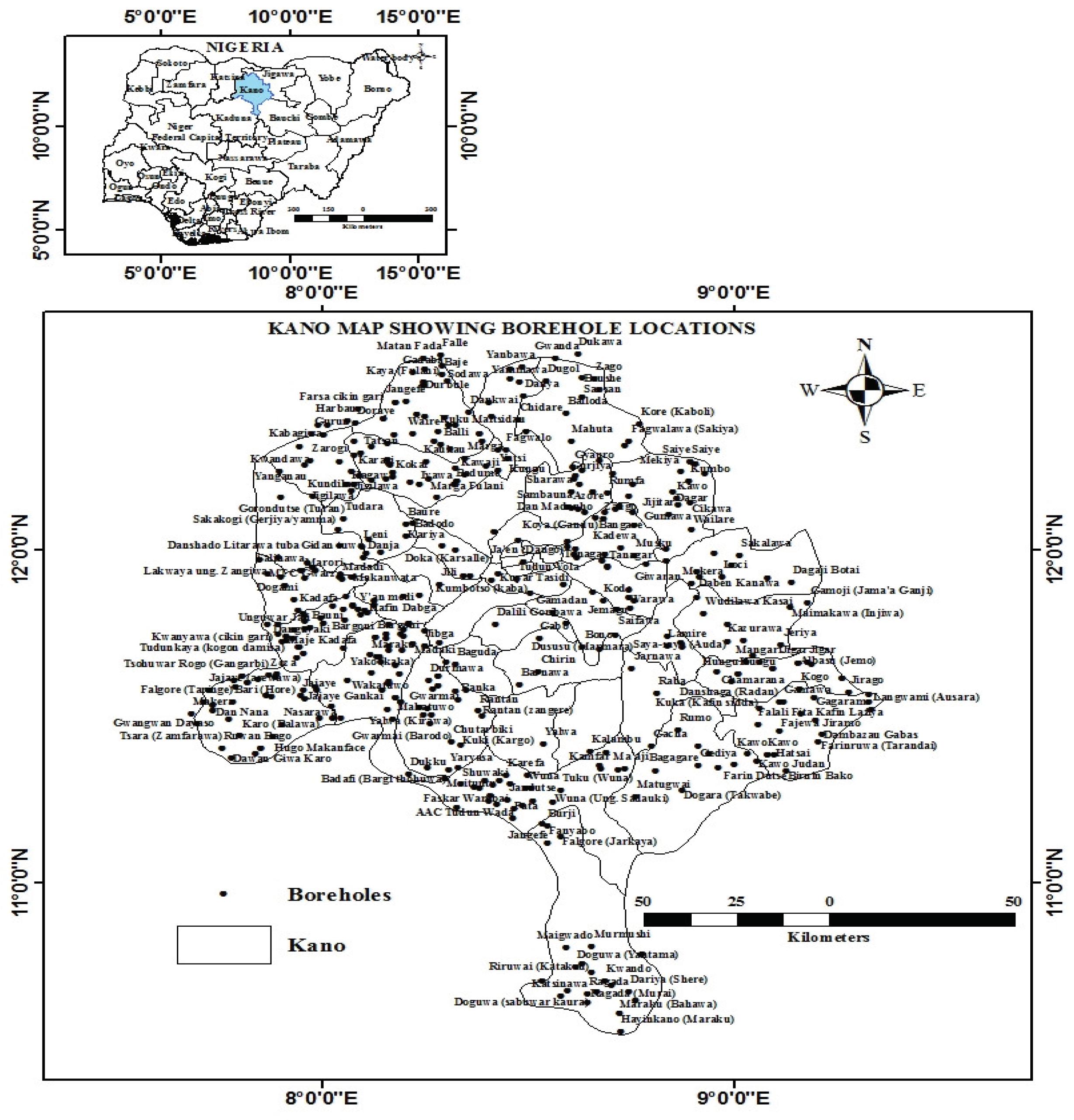
Figure 2.
Flowchart of the methodology used for GWP mapping.
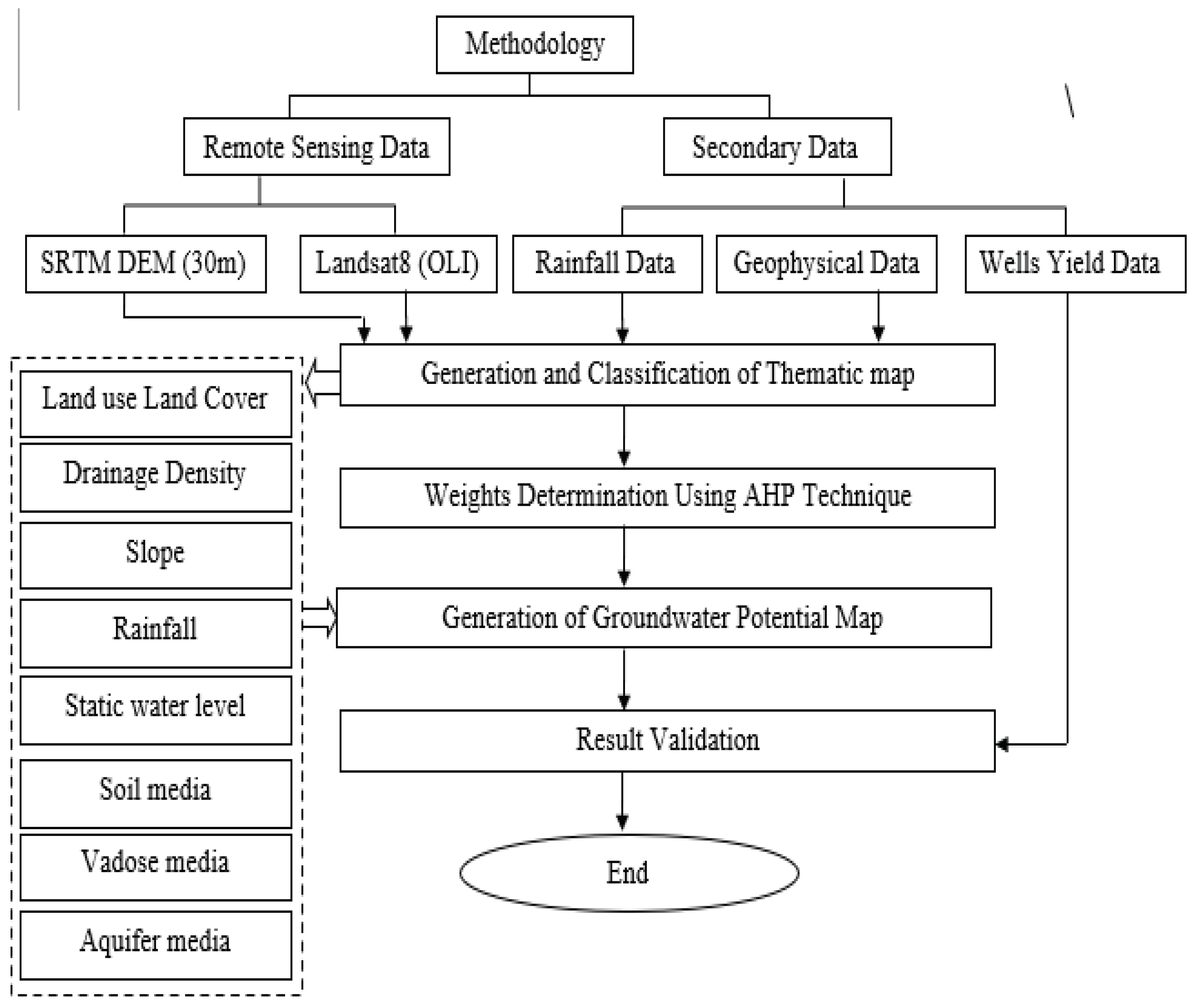
Figure 3.
LULC map.
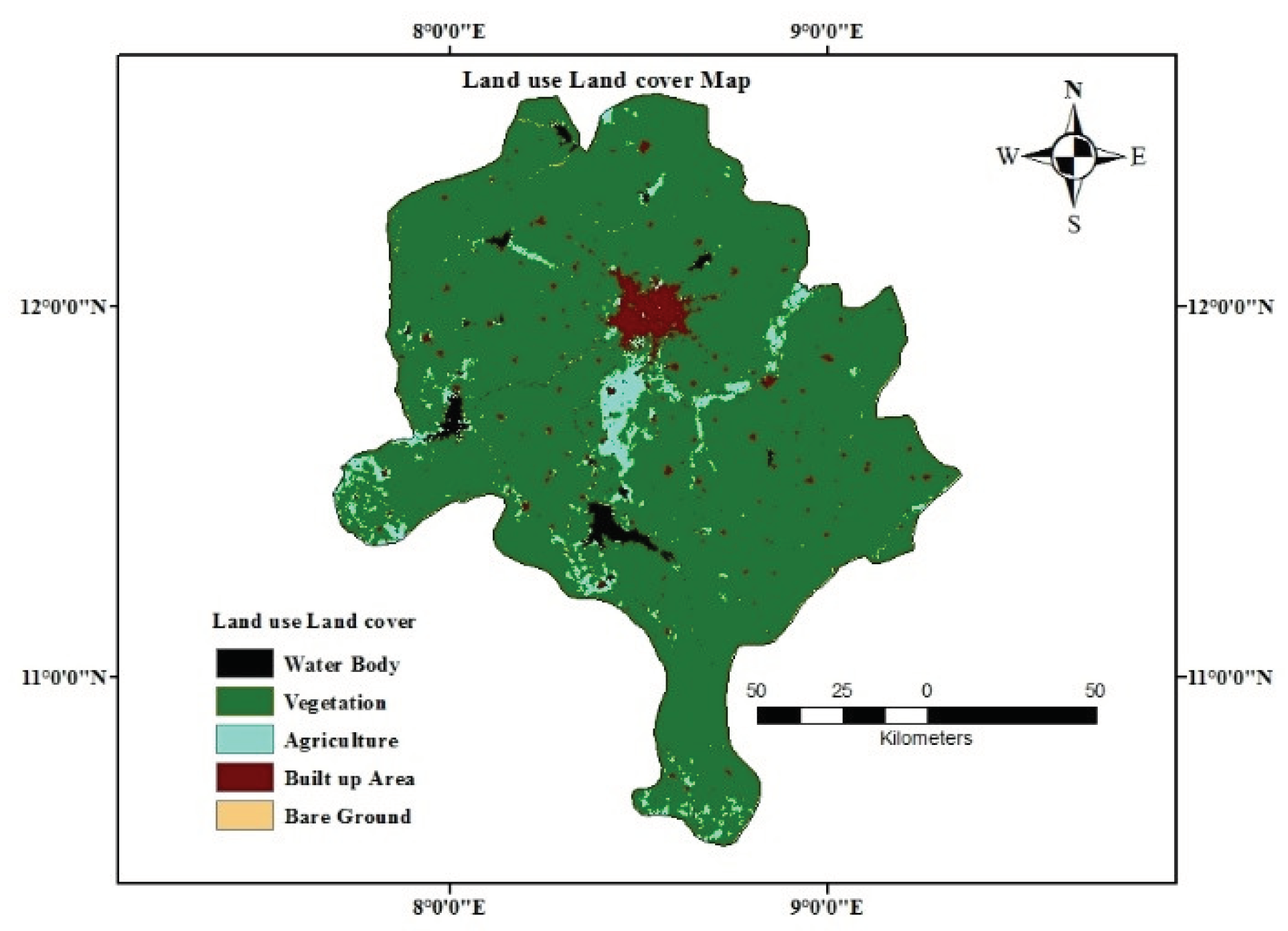
Figure 4.
Drainage density map.
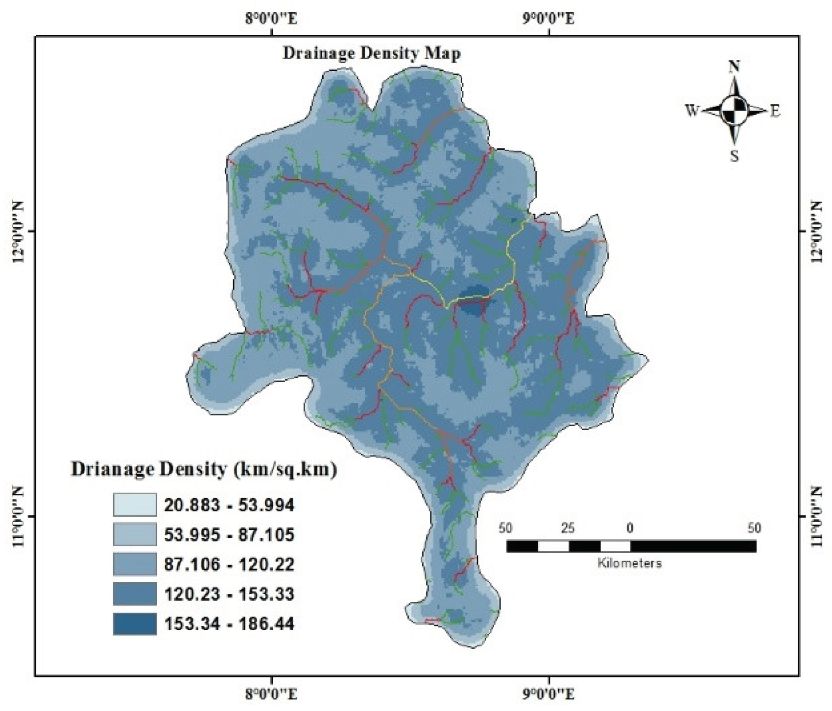
Figure 5.
Slope map.
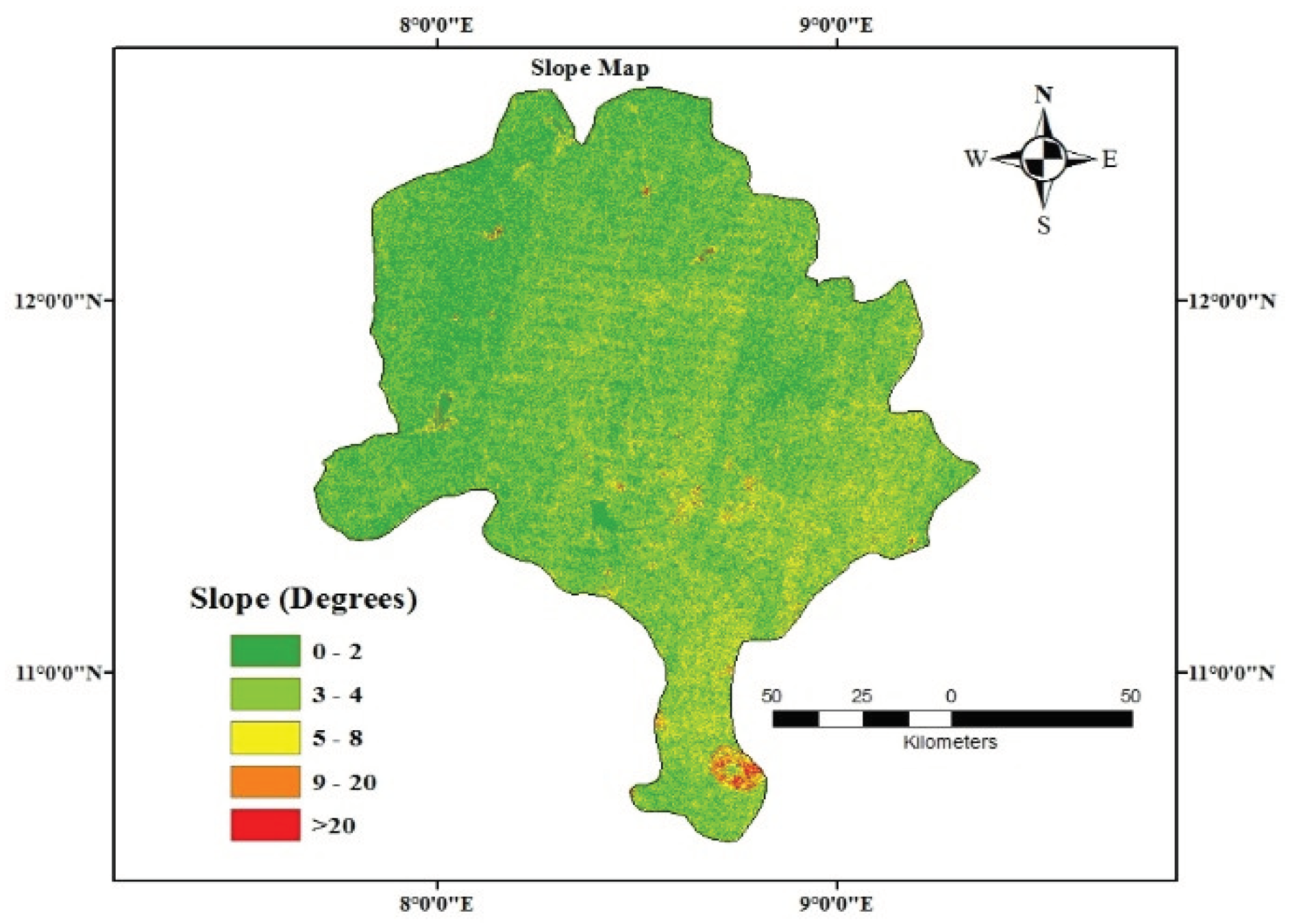
Figure 6.
Rainfall map.
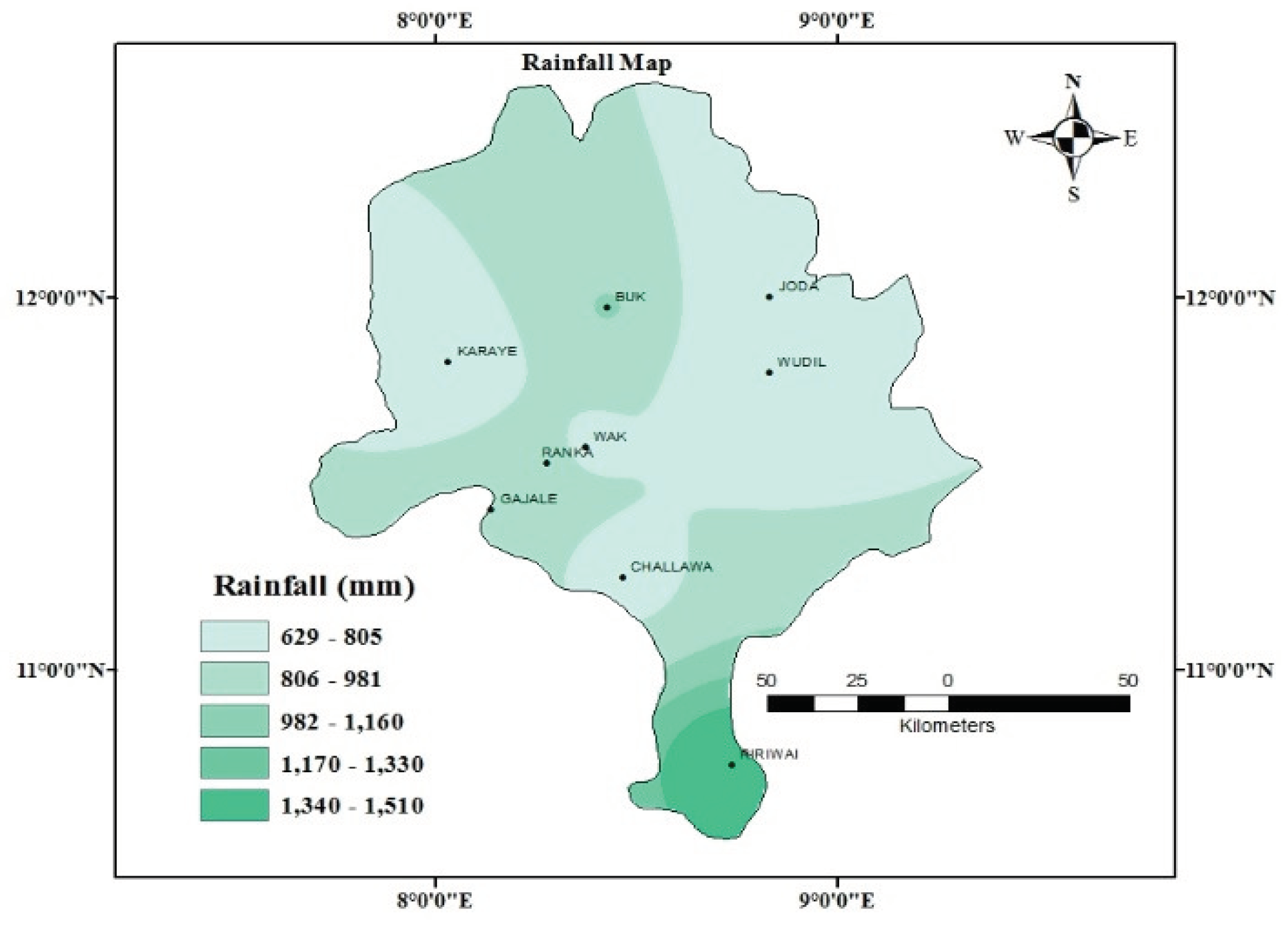
Figure 7.
Static watr level map.
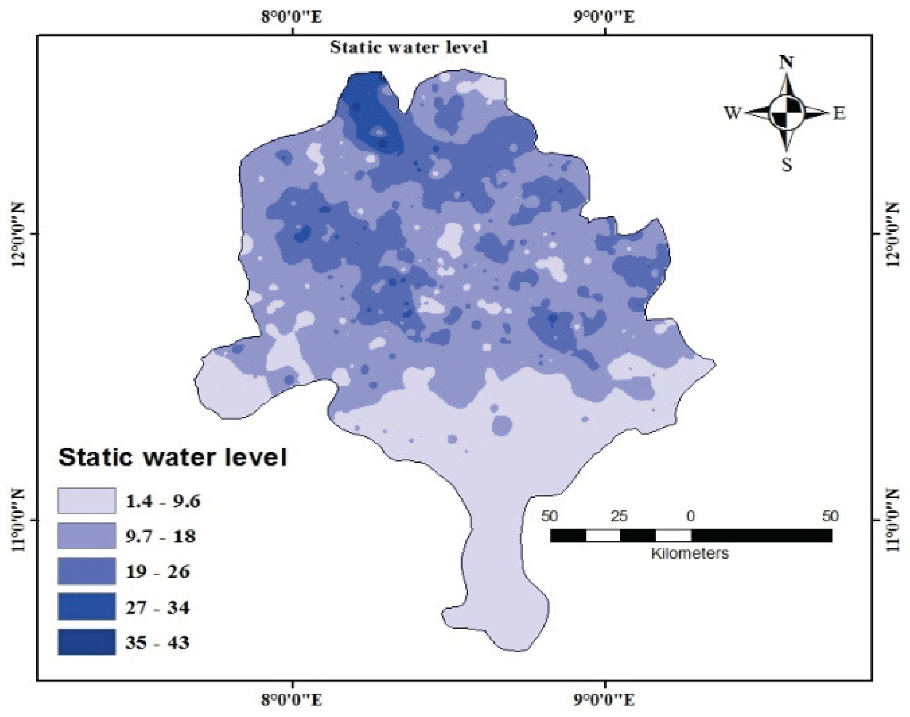
Figure 8.
Soil media map.
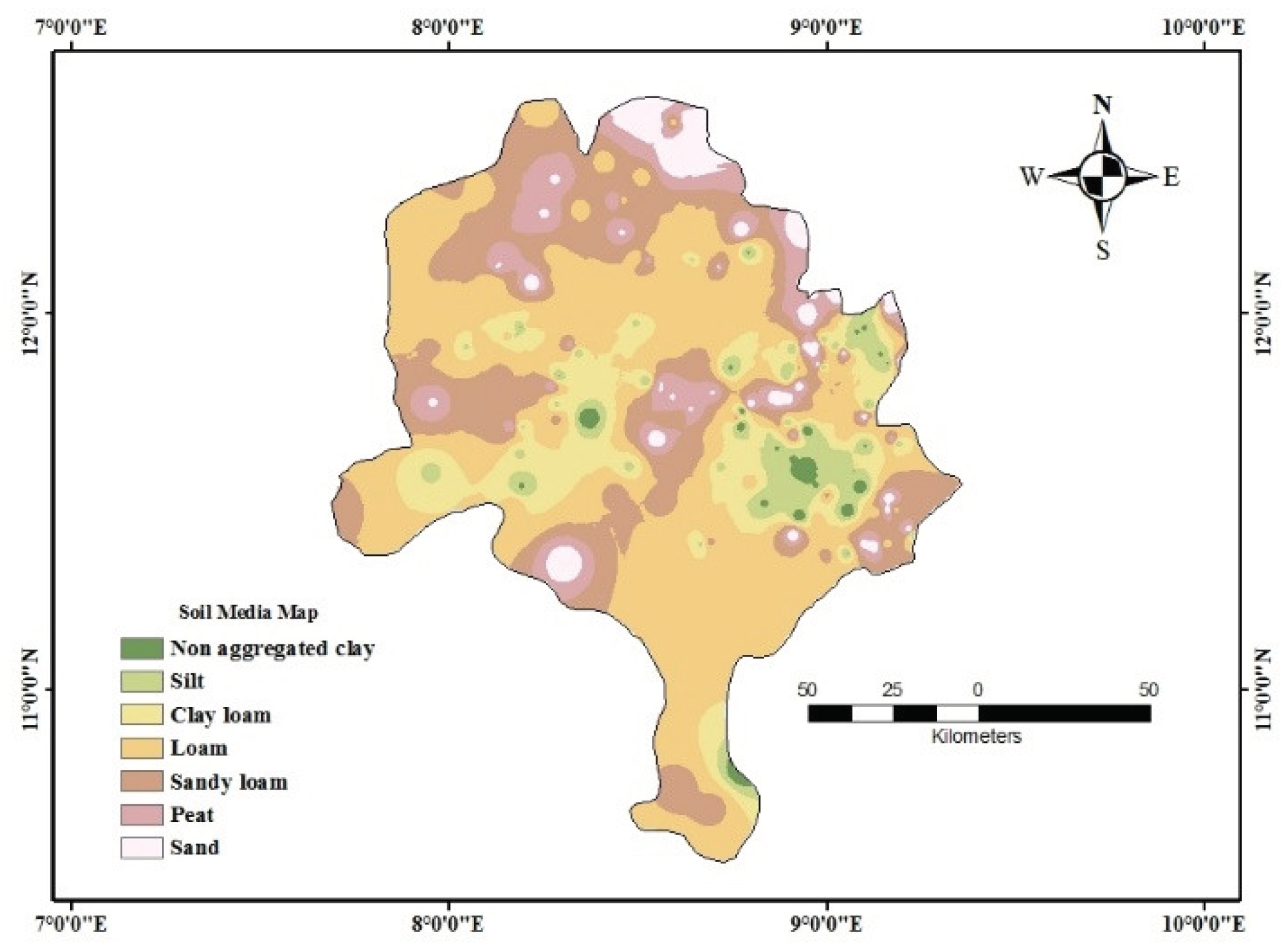
Figure 9.
Vadose media map.
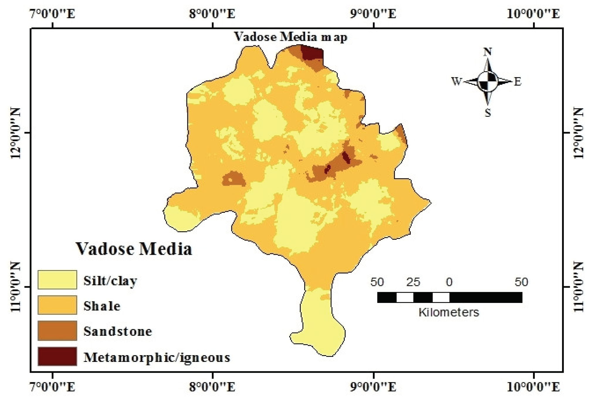
Figure 10.
Aquifer media map.
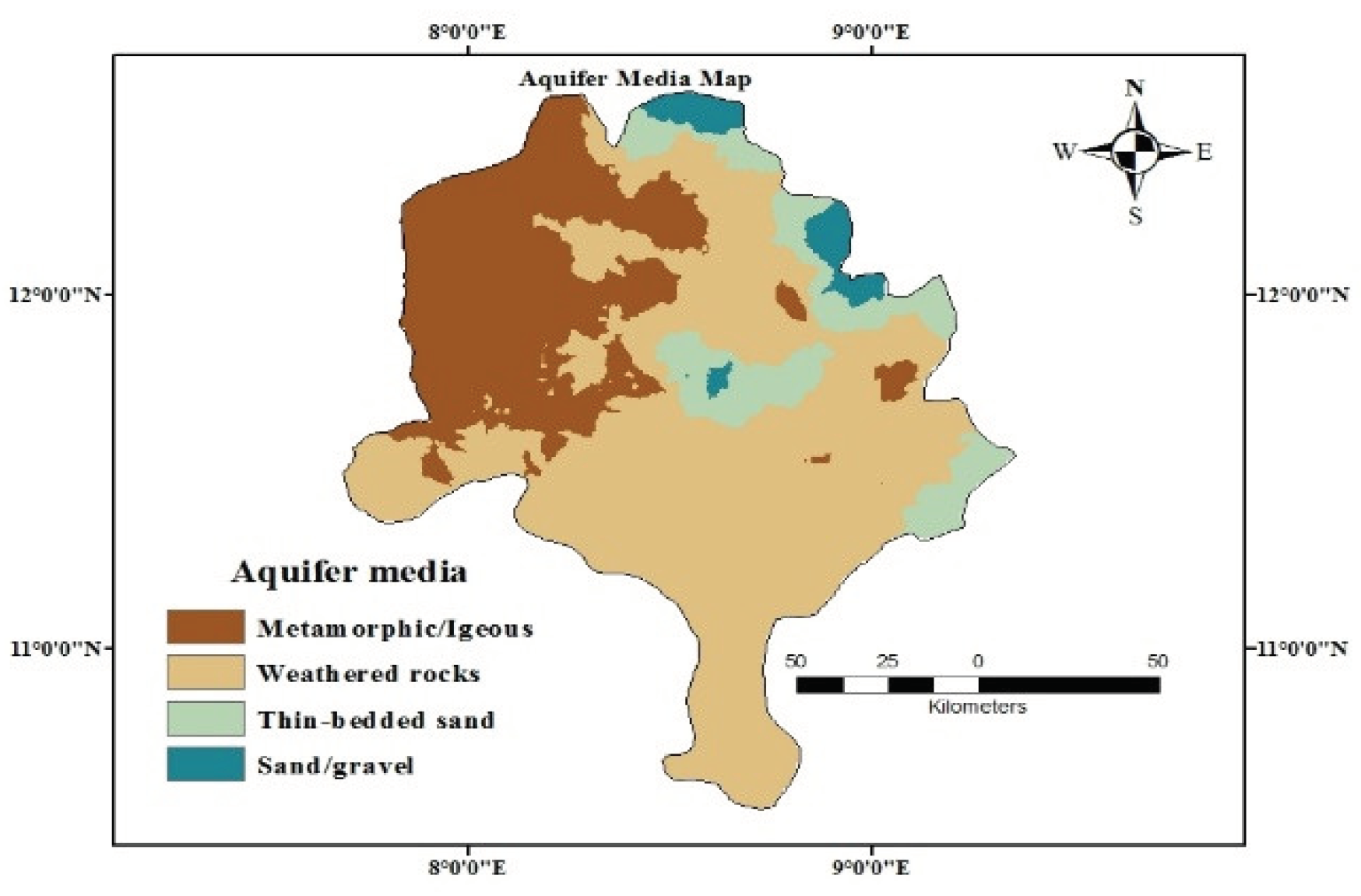
Figure 11.
GWP map.
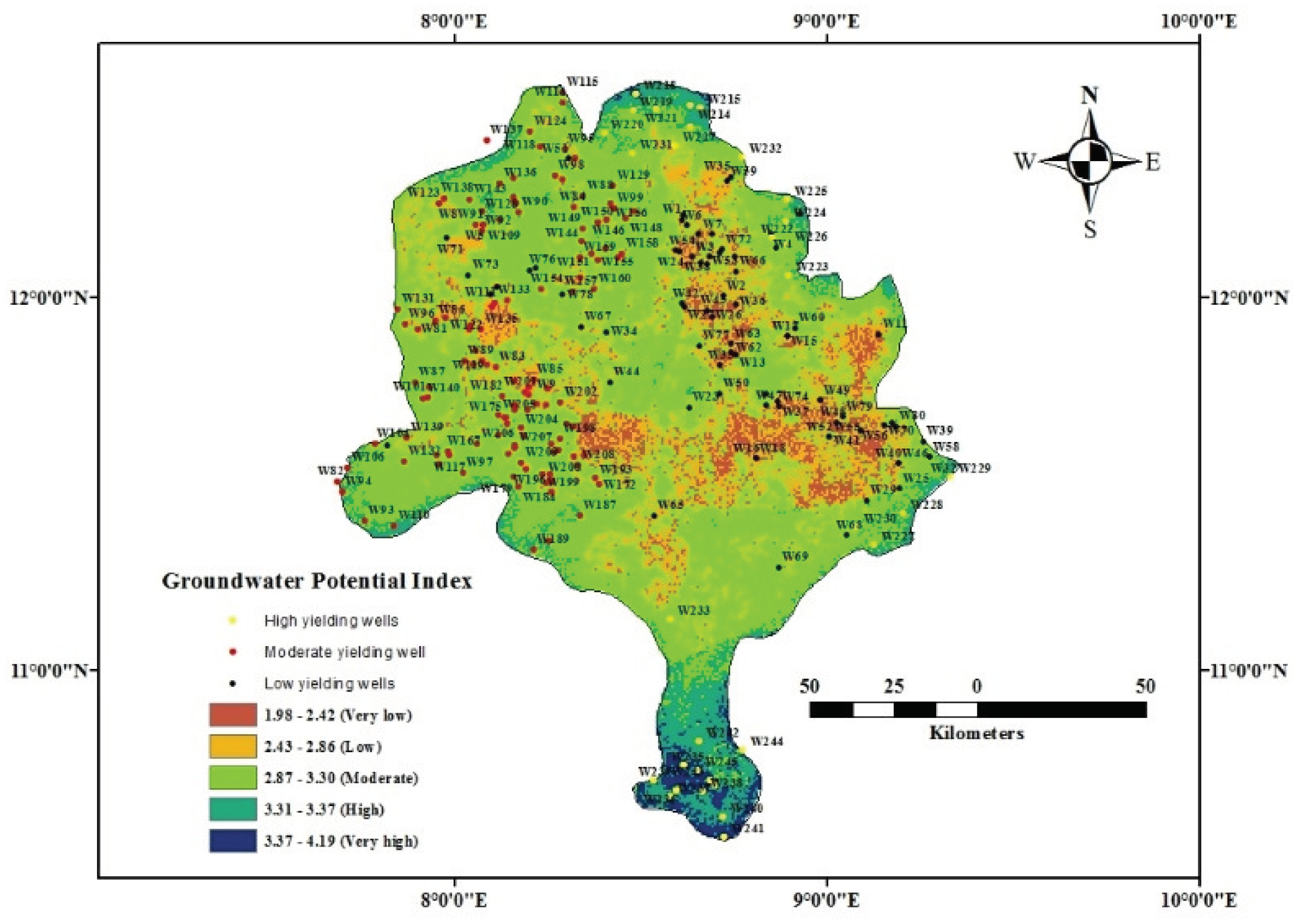
Figure 12.
GWP index and yield relationship.
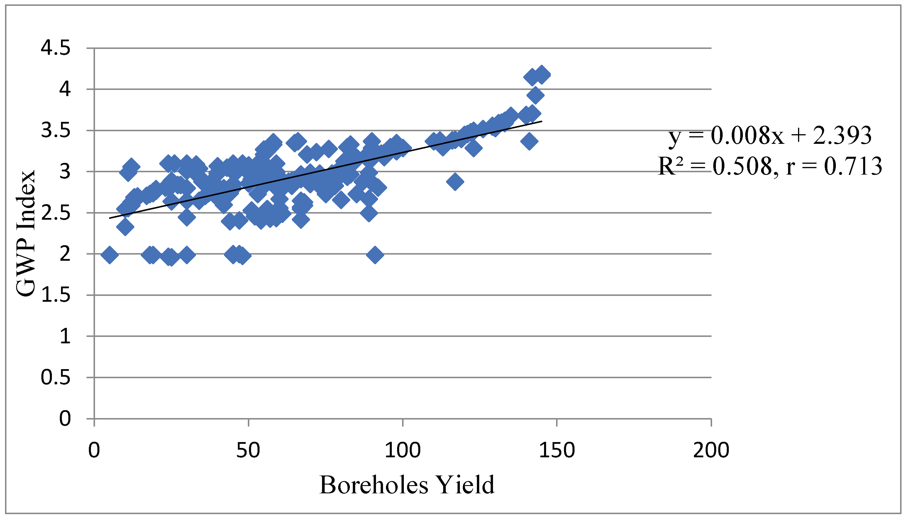

Table 1.
AHP model pair wise comparison matrix among parameters.
| Parameters | P1 | P2 | P3 | P4 | P5 | P6 | P7 | P8 | Weight |
|---|---|---|---|---|---|---|---|---|---|
| LULC (P1) | 1.00 | 0.33 | 0.33 | 0.25 | 0.50 | 1.00 | 0.33 | 0.50 | 4.24 |
| Drainage Density (P2) 3.00 | 1.00 | 0.50 | 0.50 | 3.00 | 3.00 | 1.00 | 2.00 | 14.0 | |
| Slope (P3) | 3.00 | 2.00 | 1.00 | 0.50 | 3.00 | 3.00 | 2.00 | 2.00 | 16.5 |
| Rainfall (P4) | 4.00 | 2.00 | 2.00 | 1.00 | 3.00 | 3.00 | 2.00 | 2.00 | 19.0 |
| Static water level (P5) | 2.00 | 0.33 | 0.33 | 0.33 | 1.00 | 2.00 | 0.50 | 0.50 | 6.99 |
| Soil media (P6) | 1.00 | 0.33 | 0.33 | 0.33 | 0.50 | 1.00 | 0.33 | 0.33 | 4.15 |
| Vadose media (P7) | 3.00 | 1.00 | 0.50 | 0.50 | 2.00 | 3.00 | 1.00 | 2.00 | 13.0 |
| Aquifer media (P8) | 2.00 | 0.50 | 0.50 | 0.50 | 2.00 | 3.00 | 0.50 | 1.00 | 10.0 |
| Sum | 19.0 | 7.49 | 5.49 | 3.91 | 15.0 | 19.0 | 7.66 | 8.53 | 86.08 |
Table 2.
Normalized pair wise comparison matrix and weights of each parameter.
| Parameters | P1 | P2 | P3 | P4 | P5 | P6 | P7 | P8 | Weight |
|---|---|---|---|---|---|---|---|---|---|
| LULC (P1) | 0.053 | 0.044 | 0.060 | 0.064 | 0.033 | 0.053 | 0.043 | 0.049 | 0.049 |
| Drainage Density (P2) | 0.158 | 0.134 | 0.091 | 0.128 | 0.200 | 0.158 | 0.131 | 0.194 | 0.149 |
| Slope (P3) | 0.158 | 0.267 | 0.182 | 0.128 | 0.200 | 0.158 | 0.261 | 0.194 | 0.194 |
| Rainfall (P4) | 0.2110.267 | 0.364 | 0.256 | 0.200 | 0.158 | 0.261 | 0.194 | 0.239 | |
| Static water level (P5) | 0.105 | 0.044 | 0.060 | 0.084 | 0.067 | 0.105 | 0.065 | 0.049 | 0.073 |
| Soil media (P6) | 0.053 | 0.044 | 0.060 | 0.084 | 0.033 | 0.053 | 0.043 | 0.032 | 0.051 |
| Vadose media(P7) | 0.158 | 0.134 | 0.091 | 0.128 | 0.133 | 0.158 | 0.131 | 0.194 | 0.141 |
| Aquifer media (P8) | 0.105 | 0.067 | 0.091 | 0.128 | 0.133 | 0.158 | 0.065 | 0.097 | 0.106 |
| Sum | 1.001 | 1.001 | 1.000 | 1.000 | 1.000 | 0.981 | 1.000 | 1.003 | 1.002 |
Table 3.
Parameters weight and their ranking for GWP.
| Parameters | Sub classes | Ranks () | Weight () | Area (km2) | Area (%) |
| LULC | Water body | 5 | 0.049 | 317 | 1.58 |
| Vegetation | 4 | 18285 | 90.83 | ||
| Agriculture | 4 | 909 | 4.5 | ||
| Built up area | 3 587 2.92 | ||||
| Bare ground | 2 | 33 | 0.17 | ||
| Drainage | |||||
| Density (km/km2) | 20.883 – 53.994 | 5 | 0.149 | 130.0 | 0.65 |
| 53.995 – 87.105 | 4 | 10260 50.95 | |||
| 87.106 – 120.22 | 3 | 7828 | 38.90 | ||
| 120.23 – 153.33 | 2 | 1693 | 8.41 | ||
| 153.34 – 186.44 | 1 | 220.0 | 1.09 | ||
| Slope (Degrees) | (0 - 2) | 5 | 0.194 | 8949 | 44.45 |
| (3 - 4) | 4 | 9058 | 45.00 | ||
| (5 - 8) | 3 | 1879 | 9.37 | ||
| (9 - 20) | 2 | 195 | 0.97 | ||
| (>20) | 1 | 50 | 0.25 | ||
| Rainfall (mm) | 1340 – 1510 | 5 | 0.239 | 748 | 3.70 |
| 170 – 1330 | 4 | 295 | 1.48 | ||
| 982 – 1160 | 3 | 276 | 1.37 | ||
| 806 – 981 | 2 | 8825 | 43.85 | ||
| 629 – 805 | 1 | 9987 | 49.60 | ||
| Static water level (m) | 1.4 – 9.6 | 5 | 0.073 | 6358 | 31.6 |
| 9.7 – 18 | 4 | 9103 | 45.2 | ||
| 19 – 26 | 3 | 4187 | 20.8 | ||
| 27 – 34 | 2 | 463 | 2.30 | ||
| 35 – 43 | 1 | 20 | 0.10 | ||
| Soil media | Sand | 5 | 0.051 | 184 | 0.92 |
| Sandy loam | 4 | 1018 | 5.06 | ||
| Peat | 4 | 2664 | 13.2 | ||
| Loam | 3 | 8968 | 44.6 | ||
| Silt | 2 | 4756 | 23.6 | ||
| Clay loam | 2 | 1736 | 8.62 | ||
| Non aggregated clay | 1 | 805 | 4.0 | ||
| Vadose media | Sandstone | 4 | 0.141 | 824 | 4.0 |
| Metamorphic/igneous | 3 | 175 | 0.87 | ||
| Shale | 3 | 12422 | 61.7 | ||
| Silt/clay | 2 | 6710 | 33.33 | ||
| Aquifer media | Sand/gravel | 5 | 0.106 | 613 | 3.0 |
| Thin-bedded sand | 4 | 218911.0 | |||
| Metamorphic/igneous | 3 | 5647 | 28.0 | ||
| Weathered rock | 3 | 1682 | 58.0 |
Table 4.
Classification of boreholes yield of the study area according to [19].
Table 4.
Classification of boreholes yield of the study area according to [19].
| S/No | Boreholes ID | Classification (l/min) | Category |
|---|---|---|---|
| 1 | W1 - W80 | <50 | Low |
| 2 | W81 – W209 | 50 – 100 | Moderate |
| 3 | W210– W245 | >100 | High |
Disclaimer/Publisher’s Note: The statements, opinions and data contained in all publications are solely those of the individual author(s) and contributor(s) and not of MDPI and/or the editor(s). MDPI and/or the editor(s) disclaim responsibility for any injury to people or property resulting from any ideas, methods, instructions or products referred to in the content. |
© 2024 by the authors. Licensee MDPI, Basel, Switzerland. This article is an open access article distributed under the terms and conditions of the Creative Commons Attribution (CC BY) license (http://creativecommons.org/licenses/by/4.0/).
Copyright: This open access article is published under a Creative Commons CC BY 4.0 license, which permit the free download, distribution, and reuse, provided that the author and preprint are cited in any reuse.


