
Submitted:
19 January 2024
Posted:
19 January 2024
You are already at the latest version
Abstract
The integration of nature-based solutions into land use optimization has emerged as a focal point of current research, primarily due to its efficacy in mitigating flooding impacts and fostering sus-tainable development in both urban and rural areas. Utilizing Shanghai Pujiang Country Park as a case study, this paper conducts a simulation analysis to assess the flood mitigation effectiveness of three distinct land use patterns (Natural scenario, Scenario N; Complete urbanization scenario, Scenario U; Country Park Planning scenario, Scenario P) under five stormwater scenarios with re-turn periods of 2, 5, 10, 20, and 50 years. The findings reveal that Scenario P exhibits superior flood mitigation performance, particularly under stormwater scenarios with a return period of less than 50 years. Building upon these results, the paper proposes recommendations for optimizing land use with a focus on mitigating the impact of flooding. This study is crucial for comprehending the mechanisms involved in urban stormwater logging mitigation through land use methods and holds significance for decision-making in land use and planning at the micro level.
Keywords:
flood regulation service
; land use optimization
; urban-rural fringe area
; Pujiang Country Park
1. Introduction
Under the background of climate change and rapid urbanization, urban population and scale continue to expand, and a large number of wetlands and farmland are replaced by impervious ground, which leads to increasingly prominent problems such as flood disasters, water shortage, water quality deterioration, and ecosystem degradation. Especially flood disaster has become one of the most costly disasters in the world, and presents a fluctuating upward trend [1], Frequent floods have also caused serious loss of life and property in China [2]. Therefore, how to reduce urban-rural flood disaster risk, enhance urban resilience, and improve disaster risk adaptation have currently become topical issues. In this context, research on Nature-based Solutions (NbS) for flood risk mitigation through land use adjustments has attracted academic attention [3,4,5,6,7,8]. Currently, a large number of research results have been developed on the assessment of flood risk with multiple land use scenarios and the impact of land use change on flooding processes [3,4,5,6]. Peng et al. (2018) studied the flood risks under various rainstorm disaster-land use disaster-induced scenarios in the Maozhou River Basin of Shenzhen, and concluded that the increase of construction land aggravated the stormwater flood risk [9]. Jiang et al. (2022) found that upstream and downstream land use changes have different effects on the flooding process in the Piedmont Plain area based on multi-scenario numerical simulation [10].On this basis, some scholars further combined flood risk evaluation with land use, and propose to adjust the land use structure and layout through ecological space bottom line control, combined with local natural geographic patterns, to mitigate flood risks [4,7,11,12,13]. However, most of the existing studies focus on large and medium scales such as watersheds, and the specificity of small-scale spatial elements and the response of land use changes to flood risks are not sufficiently considered, which makes it difficult to implement precise spatial control policies in the land use planning [14].
In recent years, China has also explored the construction of "sponge cities" in practice. In Shanghai, country parks have become an important ecological space for urban-rural development through a combination of land remediation and village development measures [15,16], which play an important role in mitigating flood risks and improving resilience in urban and rural areas [17,18]. However, as a key node of "countryside ecological space" in the《Shanghai Basic Ecological Network Plan》, country parks integrate ecological, production and living functions, and are easily replaced by construction land. Therefore, this study selects the Pujiang Country Park as the study area, which is the nearest to the urban built-up area, and evaluates the flood regulation function under five 1-h stormwater scenarios with return periods of 2 years, 5 years, 10 years, 20 years, and 50 years by three land use scenarios constructed, including natural situation, full urbanization, and country park planning. On this basis, land use optimization suggestions for mitigating urban flood risks are proposed to provide a decision basis for stabilizing urban ecological space, determining urban growth boundaries reasonably, and improving the urban-rural areas resilience of flood risks.
2. Materials and Methods
2.1. Study Area
Pujiang Country Park is an important ecological node at the intersection of the Shanghai Municipal Ecological Spacing Belt, Suburban Green Ring, Dazhi River Ecological Corridor and Jinhui Port Ecological Corridor, and is a spacing green belt that connects the central city with the peripheral green space and limits the continuous development of the main urban area. The park is located in the southeastern part of Minhang District and the western part of Pujiang Town (Figure 1), with the central area of Pujin Street to the north, Luhui community and large residential communities to the south, Huangpu River to the west, and the old community of Tanjiagang to the east. The area is about 15.2 km2, with a registered population of 25,400, a foreign population of 10,700, and an agricultural population of 0.56 million [18]. The topography of the area is low and flat, with elevations ranging from 2.4 to 3.0 m which includes five land use/cover types: farmland, water, construction land, green land and bare land. Extreme precipitation and poor drainage in summer can easily cause waterlogging. With the urbanization of the suburbs, the risk of flood is gradually increasing.
2.2. Data
Research data includes multiple types of data such as land use data, soil data, elevation data, precipitation, and building data. First, land use data were derived from Shanghai Minhang District Planning and Natural Resources Bureau, including land use vector data in 2013(Figure 2a) and Pujiang Country Park planning data (Figure 2b).
Second, soil data were obtained from the Nanjing Soil Institute of the Chinese Academy of Sciences. In conjunction with the research conducted by Hou et al(1992) titled 'Shanghai Soil' [19], the soil types in Pujiang Country Park were classified into four distinct categories (labeled as A, B, C and D). This categorization was based on the criteria outlined by the Soil Conservation Service (SCS) model. In this classification, 'tidal sandy mud' falls under category A, 'dredged ash tidal soil' is assigned to category B, 'yellow mud' is designated as category C, and 'inland lakes' are classified under category D. These categories were determined based on the unique properties and minimum infiltration rates of each soil type, facilitating effective land management and environmental planning.
Third, elevation data, comprising the 1:10,000 topographic map(2010) and Lidar data (2010), were sourced from the Shanghai Institute of Surveying and Mapping [21]. To meet the specific requirements of this study, the nearest neighbour method for resampling was employed to acquire the elevation data with a spatial resolution of 1 m (Figure 2c).
Fourth, the precipitation for different return periods was calculated using the Shanghai storm intensity formula, designed by the Shanghai Engineering Design Institute. This formula was selected due to its ability to account for the uniformity of precipitation in both spatial and temporal distributions within the smaller study area.
Lastly, the building data was sourced from Google Satellite Maps and utilized to formulate three land use scenarios.
2.3. Methodology
2.3.1. Terrain Correction
Terrain correction involves adjusting the exposed surface elevation to account for the impact of surface buildings, resulting in surface elevation data that closely resembles reality. In this study, the height above ground obtained from building data, or the specified threshold/step height [22], was overlaid onto the Digital Elevation Model (DEM) data of the study area. This corrected elevation is employed for simulating flood risk.
2.3.2. Stormwater Scenarios and Land Use Scenarios Design
Given that urban stormwater events often occur within a condensed timeframe of 1-2 hours, and meteorological and municipal engineering standards commonly rely on the calculation of 1-hour precipitation [4,22], This paper employs the Shanghai stormwater intensity formula, as proposed by the Shanghai Engineering Design Institute, to calculate the 1-hour precipitation with return periods of 2, 5, 10, 20, and 50 years(Table 1).
Here, q represents the stormwater intensity (mm/h), t denotes the precipitation calendar time (min), p stands for the stormwater return period (year), and lg indicates the logarithm with a base of 10.
Addressing the research requirements, the acquired building data were utilized, taking into account the building density standards for multi-storey and high-rise residential buildings in typical towns outside the outer ring road of Shanghai, where the density is stipulated to be less than 30% [23]. Additionally, referencing the spatial arrangement of the neighbourhoods around Pujiang Country Park, the initial building data underwent adjustments to generate data reflective of different land use scenarios. Three distinct land use scenarios were established based on these adjusted building data. (Table 2).
2.3.3. Stormwater Flood Simulation
- SCS Model
The SCS model is an empirical hydrological model developed by the U.S. Department of Agriculture's Soil Conservation Service in the 1950s. It is characterized by high accuracy, few parameters, and simplicity in computation, making it widely applicable across different regions and scales [24,25,26,27]. It can be used to calculate the spatial distribution of runoff in a study area [24,28]. Some studies have utilized this model to analyze flood risk at different scales in Shanghai[1,22,29,30]. The runoff formula of the SCS model is as follows:
Where Q represents the runoff depth (mm), P is the total amount of precipitation for a single rainfall event (mm), Ia is the initial abstraction (mm), and S is the maximum potential soil−water capacity (mm).
where CN is a comprehensive parameter in the SCS model that reflects the characteristics of the study area before rainfall which is associated with factors such as soil type, land use/cover type, Antecedent Moisture Condition (AMC) of the soil in the study area before the precipitation event, and slope. In the SCS model, AMC is classified into three types: dry (AMCI), normal (AMCII) and wet (AMCIII). Based on the study area's conditions and previous research,
In this paper, the AMC was assumed at the AMCII level during the calculation process [1,31]. The CN values were determined by referring to the CN value parameter table of the SCS model (Table 3).
- 2.
- GIS-based flood simulation
The area outside the outer ring road in Shanghai is self-draining [22] and the drainage engineering plan of Pujiang Country Park has not been released to the public [32], so drainage is not considered in this study. Based on the SCS model, the total accumulated water in the study area can be determined with the following formula:
Where W is the total waterlogging volume(m3), Q is the runoff volume (mm), and S is the catchment area (m2).
3. Results
3.1. Flood Regulation Functions Assessment
The flooded areas for the three land use scenarios were presented according to the model calculations for stormwater scenarios with return periods of 2, 5, 10, 20, and 50 years (Table 4). It can be observed that with an increase in the return period of heavy rainfall, the inundation areas for all three land use scenarios consistently increase (Figure 3). However, under the same stormwater conditions, the flooded area for scenario P is the smallest. It is noteworthy that, for stormwater scenarios with return periods of 2 years, 5 years, 10 years, 20 years, and 50 years, the inundation area of scenario P is reduced by approximately 0.16 km2, 0.17 km2, 0.16 km2, 0.16 km2, and 0.10 km2 compared to scenario N. It also decreases by approximately 0.42 km2、0.40 km2、0.40 km2、0.41 km2、0.34 km2 than scenario U. This suggests that, although scenario P exhibits good flood regulation functions, its effectiveness diminishes compared to the other two scenarios as stormwater return period increases to 50 years. Additionally, the analysis reveals that, across the five stormwater scenarios, the inundated areas for all three land use scenarios are mainly concentrated in the northwest and southwest parts of the study area. The inundation depth is less than 36 cm, with the majority of the inundation depths concentrated in the range of 0 to 12 cm.
In the context of the identical stormwater scenario, scenario N exhibits minimal inundation extent and average inundation depth. The exception is a few rural houses located in the southwestern part of the study area, where the maximum inundation depth is relatively significant. Notably, the northwestern and northern portions of the study area, characterized by predominantly green land, experience marginal impacts from waterlogging. Consequently, scenario N demonstrates a discernible flood regulation capability, as illustrated in Figure 4-a.
Scenario U exhibits a notable increase in both inundation extent and maximum inundation depth. The average inundation depth is sufficiently impactful to disrupt normal travel patterns, indicating a weakened flood regulation function compared to other scenarios. The presence of impervious surfaces significantly hampers the ground's capacity to absorb standing water, leading to a larger total volume of inundated water. Particularly affected are structures in the southwestern region, predominantly designated for construction purposes, and the northwestern area, primarily consisting of green land with supplementary construction areas. Consequently, these factors contribute to larger losses, as depicted in Figure 4-b.
Scenario P demonstrates comparatively minimal inundation extent and average depth, with only a few rural houses and structures in the northwestern part of the study area experiencing inundation and incurring minor damage. The remainder of the area is relatively unaffected by standing water, as depicted in Figure 4-c. Consequently, scenario P exhibits a more pronounced flood regulation function. This superiority becomes evident when compared to scenarios N and U under the same stormwater conditions. Notably, scenario P's effectiveness stems from a higher proportion of green land and farmland, coupled with reduced construction land areas and a relatively rational spatial layout of land use. For instance, under a stormwater scenario with a 50-year return period, the total volume of waterlogging in scenario P is 521,475.9 m³, significantly less than scenario N (542,646.6 m³) and scenario U (601,544.6 m³). Furthermore, the average inundation depth in scenario P is 3.4 cm, marking a 15% reduction compared to scenario U.
3.2. Suggestions for Land Use Optimization from the Perspective of Flood Mitigation
3.2.1. Adjustment of Land Use Structure
Upon scrutinizing the land use structure in three distinct scenarios as depicted in Figure 5, and integrating the assessment outcomes regarding flood regulation functions, the following recommendations for adjusting the land use structure are proposed:
To enhance resilience against stormwater and waterlogging disasters, it is recommended to optimize the stock of construction land and exercise moderate control over the expansion of newly added construction land. The research findings consistently indicate that, under identical stormwater scenarios, indicators such as inundation extent and depth follow the order: scenario U > scenario N > scenario P. A critical factor influencing these outcomes is the proportion of construction land, where the distribution is also observed as scenario U > scenario N > scenario P. Given this correlation, it becomes evident that an increase in the area of construction land exacerbates the risk of stormwater and waterlogging disasters. To mitigate this risk, it is suggested that Pujiang Country Park leverage the Beautiful Countryside Construction Project as an opportunity to reduce the footprint of construction land. This can be achieved through policies such as village merging and demolition. Simultaneously, inefficient factories and warehouses should be subject to renovation and redesign, transforming them into essential public service facility land. These measures aim to foster a more resilient and sustainable land use structure in the face of potential environmental challenges.
To foster ecological and livable communities, it is advisable to prioritize the construction of homes with a strong ecological focus while judiciously increasing the area dedicated to farmland and green spaces. A comparative analysis between scenario P and scenario N reveals that, under scenario P, both the inundation extent and depth are smaller than those observed in scenario N. The key disparity between the two scenarios lies in the sum of farmland and green spaces, constituting 60.7% of the study area in scenario P, a notable increase from the 48.6% recorded in scenario N. This discrepancy underscores the significance of farmland and green spaces in mitigating stormwater and waterlogging risks. Consequently, a strategic recommendation involves gradually transforming reduced construction land, highly fragmented farmland, and bare land into contiguous farmland and green spaces. This approach aims to enhance the overall resilience of the area while concurrently promoting a more sustainable and harmonious living environment.
To alleviate the impact of low-frequency heavy rainfall events, it is recommended to implement a moderate increase in the area of concave green land. Additionally, undertaking timely dredging of river and lake systems and establishing interconnections between water bodies can serve as effective measures for water storage and flood prevention.
3.2.2. Optimization of Land Use Layout
Upon comparing the land use layouts depicted in Figure 6 across three distinct scenarios and synthesizing the evaluation results of flood regulation functions, the following recommendations for adjusting the land use layout are proposed:
To enhance the flood regulation function of the farmland ecosystem within Pujiang Country Park, it is recommended to adopt a concentrated and continuous layout of farmland in the central area which entails reducing the fragmentation of farmland. Given the relatively serious inundation situation in the northwest and southwest regions of Pujiang Country Park, further suggestions include optimizing the planting structure or reinforcing infrastructure in these vulnerable areas. These adjustments aim to promote a more cohesive and resilient agricultural landscape and improve the overall flood resilience of the park.
To minimize the impact of stormwater and waterlogging disasters, it is recommended to optimize the layout of construction land within Pujiang Country Park. Concentrated distribution of construction land in the northern and eastern regions is suggested, while in the central area, a thoughtful allocation of construction land based on the requirements of public service facilities can enhance the rural living environment. In areas where inundation is relatively severe, particularly in the northwest and southwest of Pujiang Country Park, precautionary measures should be implemented. During the architectural design process for villages in these areas, considerations such as raising the height of buildings off the ground through the use of thresholds or steps should be employed for renovation. These measures collectively contribute to minimizing the vulnerability of structures to flooding events.
To enhance water management and flood resilience, propose building an "ecological, open, and parallel" river network system within Pujiang Country Park. Focus on improving the canal system water conservancy project in the central region. In the northwest and southwest areas, enhance water system connectivity by constructing drainage networks, pumping stations, and adopting strategies such as returning farmland to lakes or creating artificial lakes in low-lying zones. These measures aim to boost flood storage and prevention capabilities effectively. Simultaneously, consider constructing green belts on both sides of the river corridor to serve as natural ecological buffers for barges. Implement the creation of green belts along main roads, branch roads, and rivers. Utilize line-of-sight analysis and infrastructure construction, coupled with the development of activity venues, to enhance the precision of micro-terrain design [33].
4. Conclusions
In this study, Pujiang Country Park in Shanghai serves as a case study, employing the scenario analysis method to assess the flood regulation function of three land use scenarios across five stormwater scenarios. The findings are summarized as follows:
Scenario P consistently outperforms scenarios N and U in flood regulation function under equivalent stormwater scenarios. Across return periods of 2, 5, 10, 20, and 50 years, scenario P exhibits the smallest inundation area. While the reduction in the inundation area of scenario P becomes less pronounced with an increase in the return period to 50 years, its average inundation depth is noteworthy, showing a 15% decrease compared to scenario U.
Through stormwater inundation simulation and a comparative analysis of the land use structure and layout of the three scenarios, it is observed that the inundation range in all three scenarios is predominantly concentrated in the northwest and southwest regions of the study area. Recommendations are made to enhance flood risk adaptation by optimizing land use structure and layout.
It is crucial to note that none of the three scenarios demonstrates a substantial degree of mitigation against flooding risk under the 50-year return period storm. Therefore, a combination of measures, with a focus on ecological mitigation, is deemed necessary to mitigate the impact of stormwater and waterlogging during extreme precipitation events.
Author Contributions
Hui Xu conceived the paper’s framework, developed the objectives of the paper, and revised the paper. Chunyang Wang & Xinchun Yu collected the case study data and wrote the manuscript; C.W. conducted the data analysis and; Qianqian Qin edited and refined the English paper language. All authors have read and agreed to the published version of the manuscript.
Funding
This research was funded by the“Ministry of Education Humanities and Social Sciences Research Projects of China”(No. 21YJC630146)and“National Natural Science Funds of China” (No. 71603168)
Institutional Review Board Statement
Not applicable.
Informed Consent Statement
Not applicable.
Data Availability Statement
No new data was created for this study.
Conflicts of Interest
The authors declare no conflict of interest.
References
- Yin, Z.E.; Xu, S.Y.; Yin, J.; Wang, J. Small-scale Based Scenario Modeling and Disaster Risk Assessment of Urban Rainstorm Water-logging. Acta Geographica Sinica 2010, 65, 553–562. [Google Scholar]
- Jiang, L.F. Analysis on the Characteristics of Flood Disaster Damage in China in Recent 76 Years. Advances in Meteorological Science and Technology 2018, 8, 11–16. [Google Scholar]
- Sun, D.C.; Wang, H.M.; Huang, J.; Liu, G.F. Analysis of Urban Flood Disaster Risk in the Poyang Lake Basin and Land Type Adjustment Strategy Study—A Case Study of Jingdezhen City. Resources and Environment in the Yangtze Basin 2018, 27, 2856–2866. [Google Scholar]
- Shiqiang, D.; Congxiao, W.; Ju, S.; Jiahong, W.; Jun, G.; Jianping, W.; Wenpeng, L.; Hui, X. Mapping the capacity of concave green land in mitigating urban pluvial floods and its beneficiaries. Sustainable Cities and Society 2019, 44, 774–782. [Google Scholar] [CrossRef]
- Shiqiang, D.; Peijun, S.; Rompaey, A.V.; Jiahong, W. Quantifying the impact of impervious surface location on flood peak discharge in urban areas. Natural hazards 2015, 76, 1457–1471. [Google Scholar] [CrossRef]
- Ye, X.D. Analysis of the Urban Waterlogging Formation Causes and Study of the Planning Countermeasures: A Case Study of Ningbo. Modern Urban Research 2015, 19–24. [Google Scholar]
- Mcdonough, K.R.; Hutchinson, S.L.; Liang, J.; Hefley, T.; Hutchinson, J. Spatial Configurations of Land Cover Influence Flood Regulation Ecosystem Services. Journal of Water Resources Planning and Management 2020, 146. [Google Scholar] [CrossRef]
- King, D.; Gurtner, Y.; Firdaus, A.; Harwood, S.; Cottrell, A. Land use planning for disaster risk reduction and climate change adaptation. International Journal of Disaster Resilience in the Built Environment 2016, 7, 158–172. [Google Scholar] [CrossRef]
- Peng, J.; Wei, H.; Wu, W.H.; Liu, Y.X.; Wang, Y.L. Storm flood disaster risk assessment in urban area based on the simulation of land use scenarios: A case of Maozhou Watershed in Shenzhen City. Acta Ecologica Sinica 2018, 38, 3741–3755. [Google Scholar]
- Jiang, W.W.; Yu, J.S.; Xu, S.G. The Impact of Urbanization on Urban Flood Process in Piedmont Plain Within Catchment Scale. Water Resources Protection 2022, 1–13. [Google Scholar]
- Jiang, L.; Yu, J.; Wen, J.H.; Tang, J.; Qi, M.F.; Wang, L.Y.; Zhang, M. Risk assessment of extreme flood in the north bank of the Hangzhou Bay under land use change scenarios. Progress in Geography 2021, 40, 1355–1370. [Google Scholar] [CrossRef]
- Wang, Q.W.; Tian, J.; Zeng, J.; Wang, N. Construction of flood adaptation network and planning response of strategy urban agglomeration in the Min Delta based on scenario simulation. Journal of Hydraulic Engineering 2022, 53, 876–889. [Google Scholar]
- Xu, S.; Ni, L.L.; Ren, L.H. Research on the spatial layout planning strategy of Beijing-Tianjin-Hebei mountainous towns based on mountain torrent prevention and control. Urban Problems 2020, 4-10+18. [Google Scholar]
- Lin, J.; Zhao, Y. TerritorialSpatialGovernanceandCentral-localCoordination: BasedonthePerspectiveof “Region-element”Coordination. Journal of Renmin University of China 2022, 36, 36–48. [Google Scholar]
- Rao, R. Research on urban ecological planning application in ecological restoration design: a case study on nanhaizi suburban park in Beijing. City Planning Review 2011, 35, 16–20. [Google Scholar]
- Luo, X.L.; Li, Z.G.; Zhou, J. Research on the Urban Ecological Spave Planning Guide of Yangtze River Economic Zone under New Urbanization: A Case of Wuhan. Modern Urban Research 2017, 21–26. [Google Scholar]
- Yu, K.J.; Li, D.H.; Yuan, H.; Fu, W.; Qiao, Q.; Wang, S.S. "Sponge city": theory and practice. City Planning Review 2015, 39, 26–36. [Google Scholar]
- Chen, Y.; Ge, Y.; Chen, R.S.; Chen, W.J.; Ye, Z.C.; Liu, H. New Development of Urban Resilience Research in Foreign Countries under the Background of Climate Change. Journal of Catastrophology 2020, 35, 136–141. [Google Scholar]
- Revision of Pujiang country unit (Country Park) planning, Minhang District, Shanghai (2015-2020). Available online: http://www.pinlue.com/article/2017/11/1705/064868614910.html 2018-05-15/2020-12-7.
- Hou, C.Q. Shanghai soil; Shanghai Science and Technology Press: Shanghai, China, 1992. [Google Scholar]
- Wang, L.Y.; Zhang, M.; Wen, J.H.; Chong, Z.T.; Ye, Q.H.; Ke, Q. Simulation of extreme compound coastal flooding in Shanghai. Advances in Water Science 2019, 30, 546–555. [Google Scholar] [CrossRef]
- Jing, Y.N.; Yin, Z.E.; Yin, J.; Wang, F.; Wen, J.H. GIS-based Analysis on Rainstorm Waterlogging Hazards in Pudong New Area in Shanghai. Journal of Catastrophology 2010, 25, 58–63. [Google Scholar]
- Technical regulations on urban planning management of Shanghai Municipality. Available online: https://www.shanghai.gov.cn/nw12939/20200815/0001-12939_972.html.
- Xianhong, M.; Min, Z.; Jiahong, W.; Shiqiang, D.; Hui, X.; Luyang, W.; Yan, Y. A Simple GIS-Based Model for Urban Rainstorm Inundation Simulation. Sustainability 2019, 11, 2830. [Google Scholar] [CrossRef]
- Lei, Y.; Liding, C.; Wei, W.; Ranhao, S. Potential reduction in urban runoff by green spaces in Beijing: A scenario analysis. Urban Forestry & Urban Greening 2015, 14, 300–308. [Google Scholar] [CrossRef]
- Ding, S.Y.; Wang, N.; Ni, L.L.; Zeng, J. Study on the inundation risk of disaster space in the Min Delta urban agglomeration based on SCS-CN and GIS coupling model. Journal of Catastrophology 2021, 1–10. [Google Scholar]
- Wu, A.K.; Huang, Y.; Zhang, S.X. Risk Assessment of Urban Waterlogging Disaster Based on SCS Model. Journal of Institute of Disaster Prevention 2020, 22, 50–57. [Google Scholar]
- Cai, W.Y.; Liu, X.P.; Zhang, J.Q. The Study of Mountain Flood Disaster Simulation Based on Distributed SCS Model. Journal of Catastrophology 2016, 31, 15–18. [Google Scholar]
- Ju, S.; Shiqiang, D.; Qingxu, H.; Jie, Y.; Min, Z.; Jiahong, W.; Jun, G. Mapping the city-scale supply and demand of ecosystem flood regulation services—A case study in Shanghai. Ecological Indicators 2019, 106, 105544. [Google Scholar] [CrossRef]
- Fei, X. Community-based Waterlogging Disaster Risk Analysis and Management. Doctor, Shanghai Normal University, Shanghai, 2019.
- Zhang, H.; Yin, Z.E.; Yin, J. Vulnerability Assessment of Urban Rainstorm water-logging in Pudong of Shanghai in terms of Land Use. Journal of Shanghai Normal University(Natural Sciences) 2011, 40, 427–434. [Google Scholar]
- Urban rainwater drainage planning of Shanghai (2020-2035). Available online: http://hd.ghzyj.sh.gov.cn/hdpt/gzcy/sj/202004/t20200429_967900.html.
- Li, J.; Zhu, Y. Conservation and Application of Native Plants in Country Parks——A Case Study of Pujiang Country Park Phase I Reconstruction in Shanghai. Landscape Architecture 2020, 25–30. [Google Scholar]
Figure 1.
Location of Pujiang Country Park.
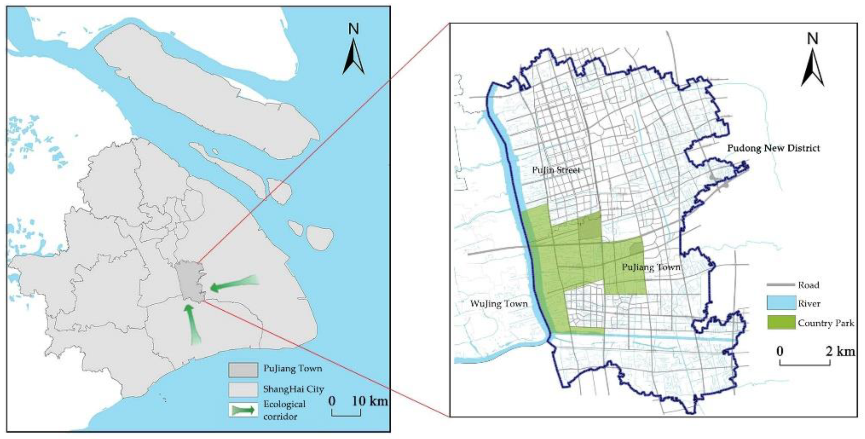
Figure 2.
Land use,soil type and Digital Elevation Model of Pujiang Country Park.
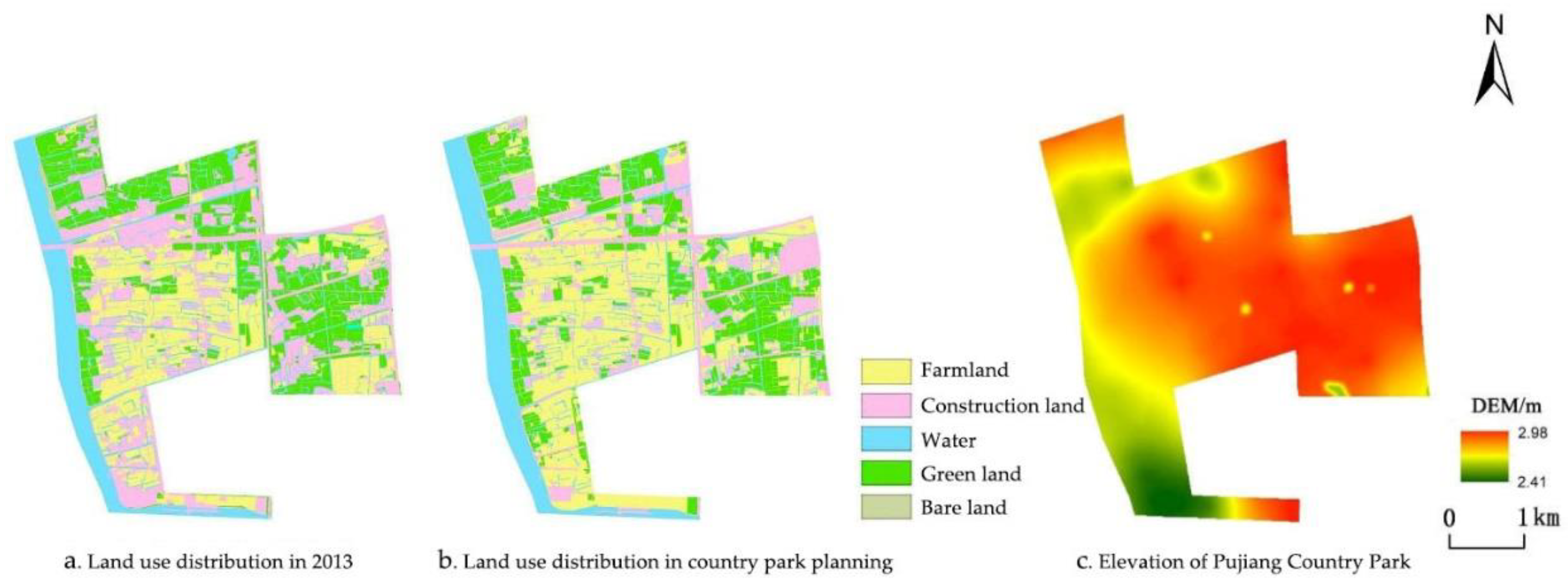
Figure 3.
Water accumulation in Pujiang Country Park and inundation area ratio of each water depth interval.
Figure 3.
Water accumulation in Pujiang Country Park and inundation area ratio of each water depth interval.
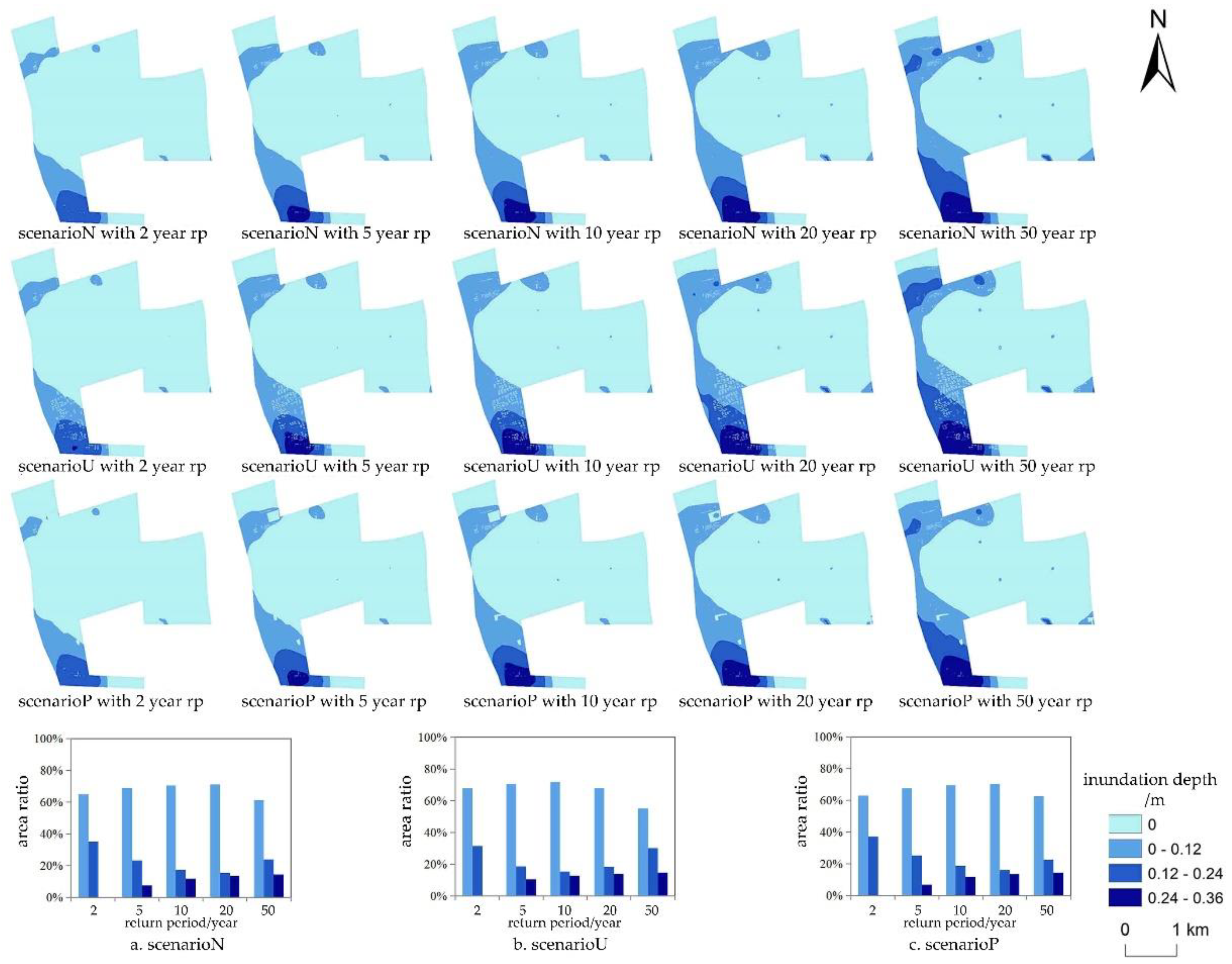
Figure 4.
Land use layout and inundation area under the stormwater scenario with return period of 50 years.
Figure 4.
Land use layout and inundation area under the stormwater scenario with return period of 50 years.
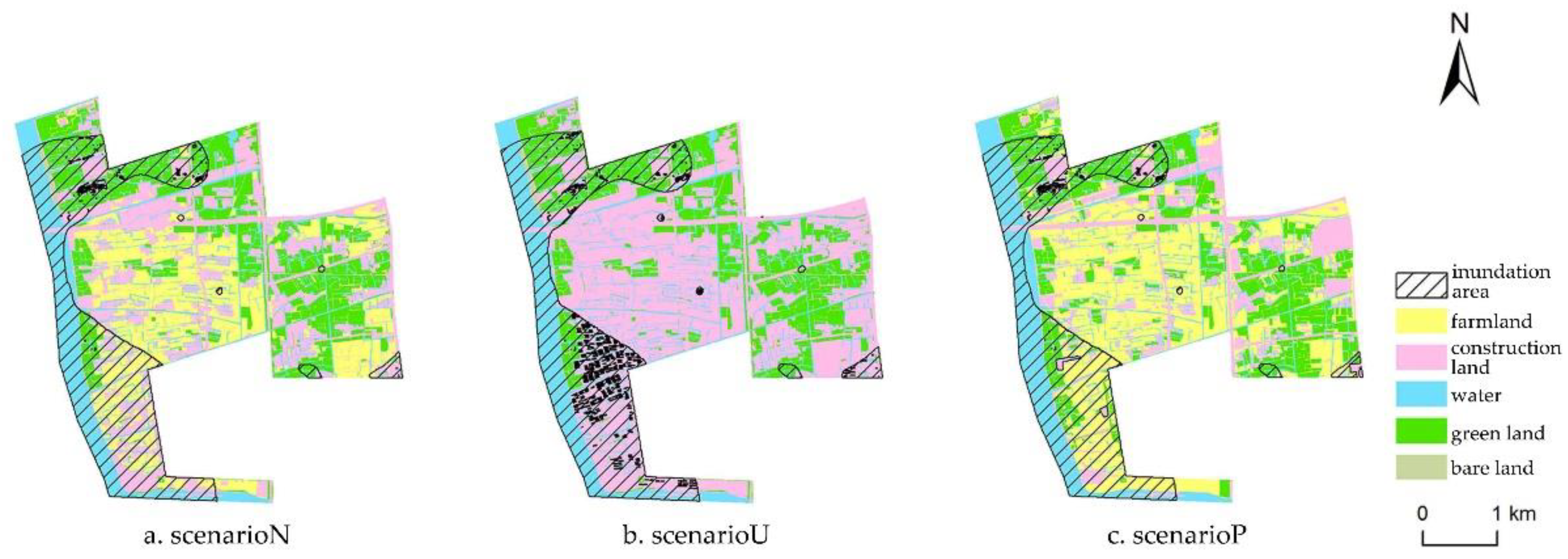
Figure 5.
Land use structure in different land use scenarios.
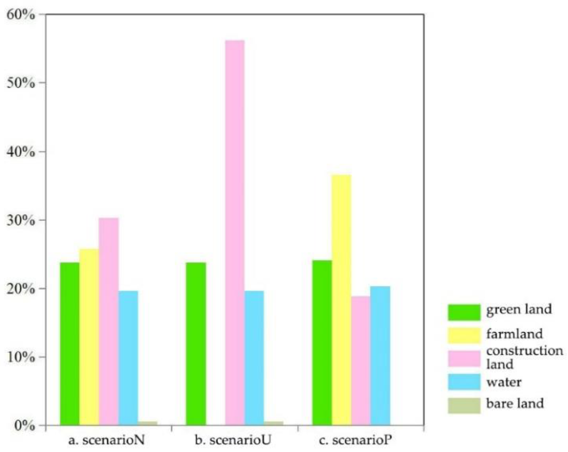
Figure 6.
Optimization scheme of land use layout.
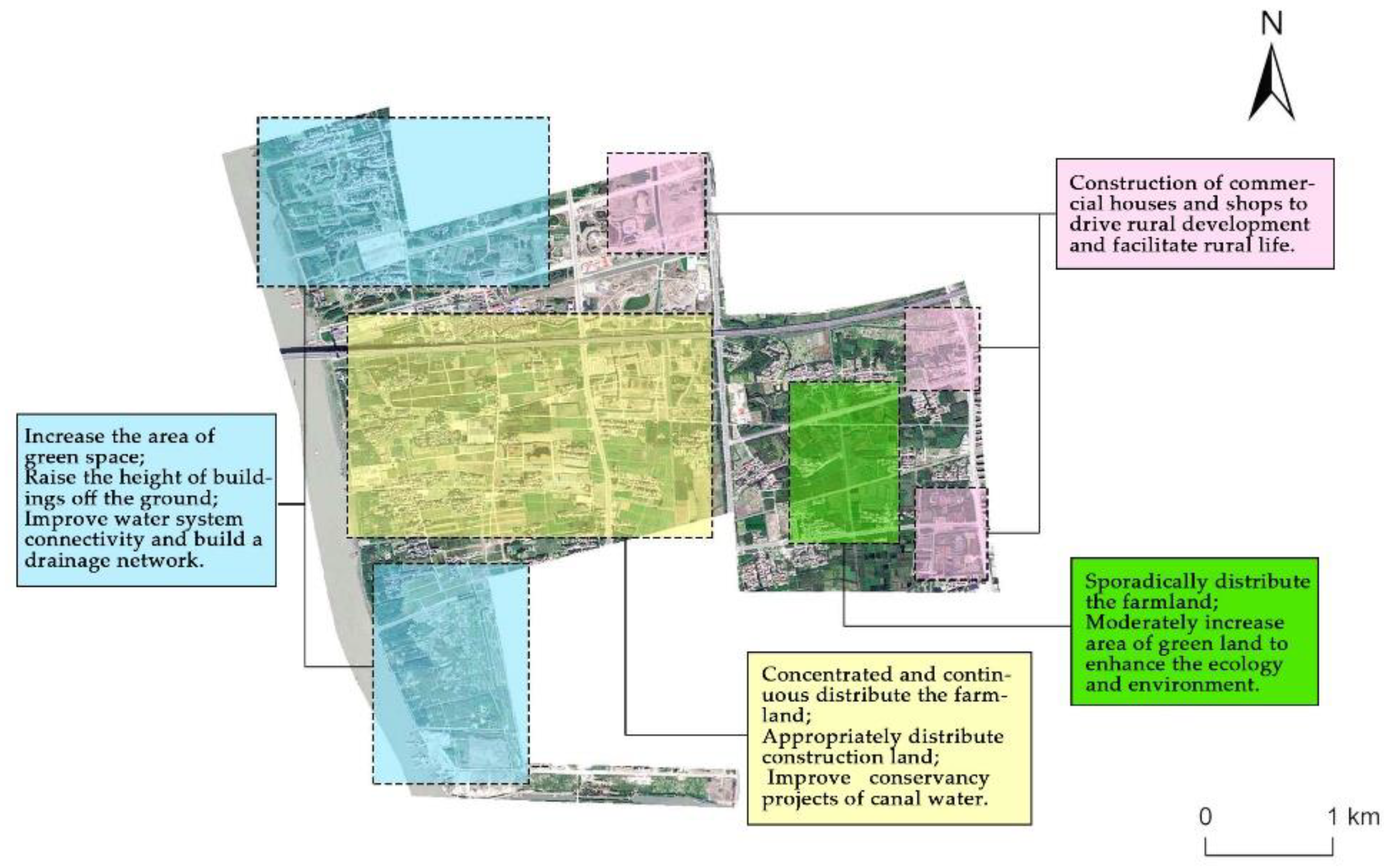

Table 1.
1-hour precipitation at different return periods.
| Return period (year) | 2 | 5 | 10 | 20 | 50 |
|---|---|---|---|---|---|
| 1-hour precipitation (mm) | 44.3 | 56.3 | 65.8 | 75.8 | 89.7 |
Table 2.
The design of land-use scenarios.
| Land use scenario | Scenario explanation |
|---|---|
| Natural scenario (scenario N) |
It refers to the natural state where land use is not affected by excessive human interference and related planning. In this paper, we utilize the 2013 land use data, predating the construction of country parks, to represent the land use status in this scenario. |
| Complete urbanization scenario (scenario U) |
It represents the condition of maximum urbanization of Pujiang Country Park. Constructed based on 2013 land use data, this scenario designates farmland as urban residential land, taking into consideration the current status of surrounding land use. |
| Country Park Planning scenario (scenario P) |
It pertains to the land use state guided by scientific planning. In this paper, we adopt the land use settings outlined in the planning of Shanghai Pujiang Country Park as the representation of the land use status in this scenario. |
Table 3.
CN value of SCS model in the Pujiang Country Park(AMCII).
| Land use/cover | Soil Permeability | |||
|---|---|---|---|---|
| A | B | C | D | |
| Construction Land | 77 | 85 | 90 | 92 |
| Bare land | 72 | 82 | 88 | 90 |
| Farmland | 67 | 76 | 83 | 86 |
| Green land | 34 | 60 | 74 | 80 |
| Water | 98 | 98 | 98 | 98 |
Table 4.
Inundation range of three land use scenarios.
| Rp |
2-year | 5-year | 10-year | 20-year | 50-year | ||||||
|---|---|---|---|---|---|---|---|---|---|---|---|
| Land use | Inundation area(km2) |
Ratio(%) | Inundation area(km2) | Ratio(%) | Inundation area(km2) | Ratio (%) |
Inundation area(km2) | Ratio (%) |
Inundation area(km2) | Ratio (%) |
|
| Scenario P | 1.89 | 12.41 | 2.66 | 17.52 | 3.21 | 21.11 | 3.76 | 24.75 | 4.52 | 29.69 | |
| Scenario N | 2.05 | 13.48 | 2.83 | 18.61 | 3.37 | 22.15 | 3.92 | 25.75 | 4.62 | 30.37 | |
| Scenario U | 2.31 | 15.21 | 3.06 | 20.10 | 3.61 | 23.71 | 4.17 | 27.44 | 4.86 | 31.93 | |
Disclaimer/Publisher’s Note: The statements, opinions and data contained in all publications are solely those of the individual author(s) and contributor(s) and not of MDPI and/or the editor(s). MDPI and/or the editor(s) disclaim responsibility for any injury to people or property resulting from any ideas, methods, instructions or products referred to in the content. |
© 2024 by the authors. Licensee MDPI, Basel, Switzerland. This article is an open access article distributed under the terms and conditions of the Creative Commons Attribution (CC BY) license (http://creativecommons.org/licenses/by/4.0/).
Copyright: This open access article is published under a Creative Commons CC BY 4.0 license, which permit the free download, distribution, and reuse, provided that the author and preprint are cited in any reuse.


