Submitted:
29 December 2023
Posted:
02 January 2024
You are already at the latest version
Abstract
In this article, you will get acquainted with ancient settlements in the Bukhara region and settlements found at the foot of the Zarafshan River. In addition, the settlements of urbanized peasant and artisan families belonging to the ancient Sugdian culture are also covered. Just as Egypt was called "the gift of the Nile" in ancient times, Buhoro oasis can also be called the gift of the Zarafshan river. Because this land on the banks of the river itself, first of all, as a result of thousands of years of Zarafshan was created due to the turbidity that flowed. The innumerable streams, lakes and ponds formed by its floods played a major role in the formation of the nature of the oasis and its development. It is known that when the ice age ended and the weather started to warm, the thick glaciers and eternal snows that covered the mountain ranges of Turkestan, Khisor and Zarafshan melted, and huge floods formed from them, roared down the Zarafshan river. His depicted floods of those times reminded of the legendary "Noah's flood". At that time, Zarafshan flowed over a very wide area in its valley. Its right bank washes the Payarik and Khatirchi hills in the present Samarkand region, and the left bank washes the Pastdargom and Kattakurgan hills. Not a single drop of this large stream was wasted in the upper and middle parts of the Zarafshan valley and was used for farming and agriculture, it broke through the narrow Khazora dar band near the present city of Navoi and flowed into the cone-shaped Bukhoro oasis. Ancient Khitfar (Vobkent-Darya), Rudnzor (Shakhrud) in Bukhara oasis. Korakuldaryo, Mokhondaryo and Taikir formed several branches and flowed along the entire voka. At that time, the valley part of Bukhoro region was formed from the lakes and swamps formed by the flood waters of Zarafshan.They are covered with thick bushes, thickets and orchards. A wealth of information has been collected on the history of the ancient nature of the people of the country and the development of its unique culture, as well as the formation of self-interested cattle breeding and farming farms, as well as the emergence of large and small villages and cities. The data serve as the main source not only for the history of the emergence of the city of Bukhara, but also for the study of the emergence of the process of urbanization in the Zara Valley and its specific characteristics.
Keywords:
Sugdian culture
; ancient village in Qumrabot
; Mokhandaryo
; Gurdush
; Gujayli
; findings of the Bronze Age
; Kalkanota and Qonimekh village ruins
; Qumrabot
; Arabon and others
1. Introduction
At the end of the 2nd millennium and the beginning of the 1st millennium BC, as it happened in the life of the people living in the steppe lands of Central Asia, the livestock farming of the tribes in the Zarafshan valley was also rapidly developing. A certain part of the semi-nomadic herdsmen settled in the lands of the river bed suitable for farming, and new farming communities began to form. However, the geographical conditions of the basin of the Mokhondarya, Gurdush and Gujayli basins, which are drying up and turning into steppes, are unsuitable for rural life, which is becoming more and more populated. In his book "Ancient History of Bukhara", the researcher Muhammadjonov.A said: "It is observed that the semi-breeding and semi-farming tribes left this ancient land and moved to the northern and northwestern parts of the current Bukhara region - the Kiziltepa and Vobkent Darya tributaries [1]. Around 20 km west of Varakhsha are monuments known as Boshtepa Group. The findings of the Late Bronze Age recorded in the lower layers of the ruins of the city of Kiziltepa, Khujabuston, Boyazdi are a clear proof of this.
2. Methods
Primitive tribes living in Kuyi Zarafshan at the end of the 2nd millennium BC and the beginning of the 1st millennium BC engaged in cattle breeding, agriculture, crafts and various professions in the foothills of Zarafshan, especially in the present-day Olot, Korakol, Jondor and Rometon areas. It has become a large pasture for the inhabitants and a shelter for hunters and fishermen. As it happened in the life of the people living in the steppe lands of Central Asia, Researcher Muhammadjonov says about the tribes of the Zarafshan valley and their lifestyle: "The rapid development process is observed in livestock farming." A certain part of the semi-nomadic herdsmen settled in the lands of the river bed suitable for farming, and new farming communities began to form. But the geographic conditions of the basin of the Mokhondarya, Gurdush and Gujayli valleys, which are drying up and turning into a steppe, will become unsuitable for rural life, whose population is growing and expanding [1]. It is observed that the semi-pastoral and semi-farming tribes left this ancient land and moved to the northern and northwestern parts of the current Bukhara region - the Kiziltepa and Vobkentdarya valleys. The researcher has another idea, that is, 20 km west of Varakhsha, the monuments known as Boshtepa group are around. The latest Bronze Age findings recorded in the lower layers of the Khujabuston Boyazdi city ruins in Kiziltepa are a clear proof of this [1]. At the same time, in the upper and middle parts of the Zarafshan valley, the villages of settled farming communities appeared on the banks of countless streams and springs, and their communication with the surrounding herding population increased. On the one hand, the rise of agriculture and animal husbandry, on the other hand, the development of professions, in particular, the development of ore smelting and the manufacture of weapons, tools and ornaments from it, and on the third hand, the expansion of barter trade between farmers and herdsmen in the Zarafshan Valley. Also, urbanization strengthens the process of ancient Sughd and leads to the formation of culture. Undoubtedly, this process is closely related to finding a new raw material, iron, and making weapons from it. It began in the 1st millennium BC.
Figure 1.
Approximate drawing of the old and present Zarafshan river.
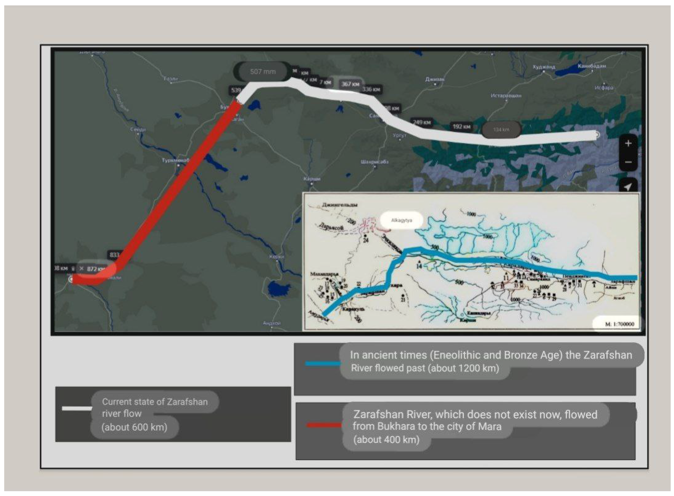
Figure 2.
The state of the Zarafshan River flowing through the territory of Uzbekistan in the Stone Age is described.
Figure 2.
The state of the Zarafshan River flowing through the territory of Uzbekistan in the Stone Age is described.
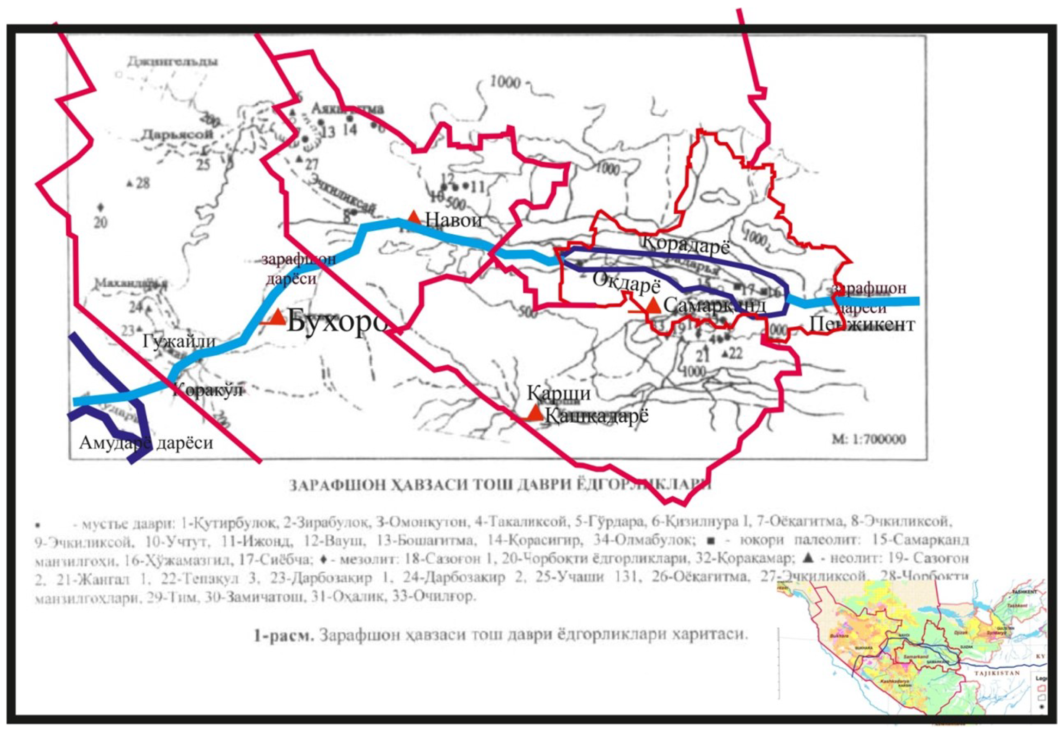
Figure 3.
Map of Bukhara 8-9 centuries.
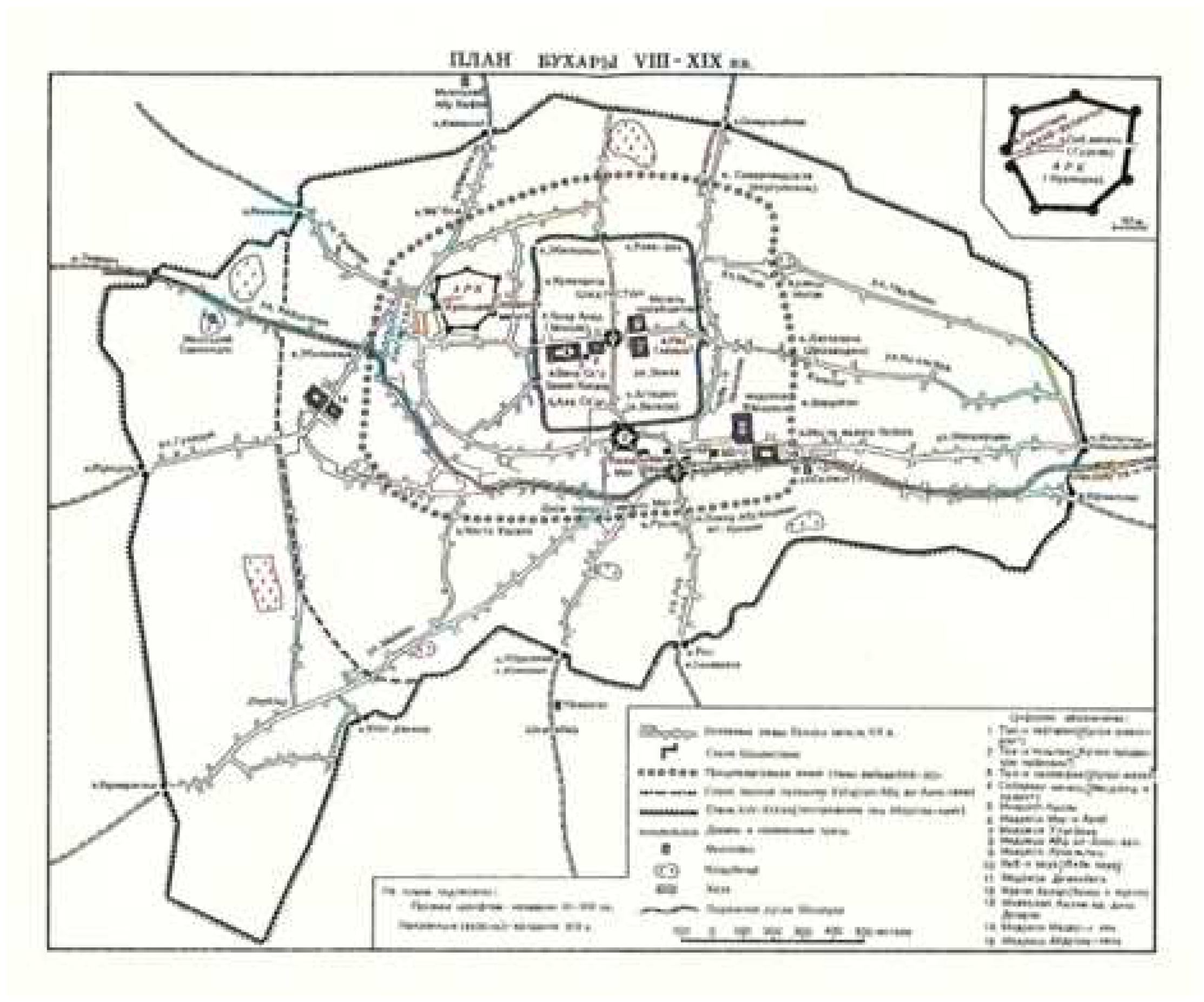
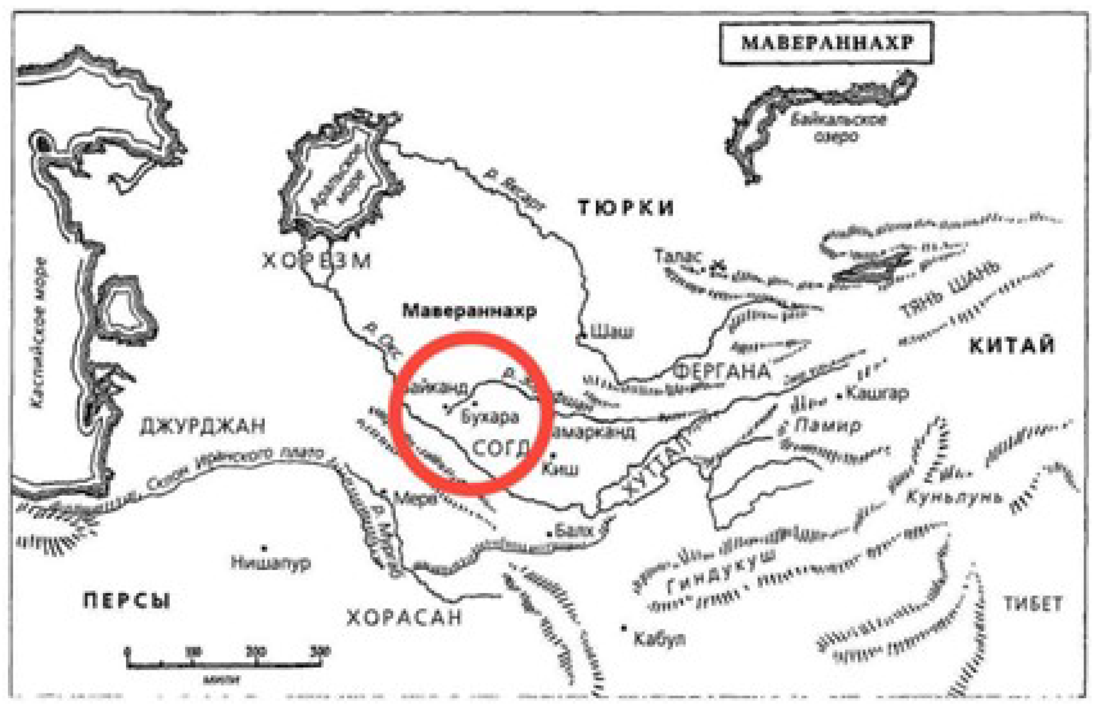
Figure 4.
Movaraunnahr map.
Villages of urbanized peasant and artisan communities belonging to the ancient Sugdian culture, belonging to the VII-V centuries BC, first rose in the middle of Zarafshan, in the present-day city of Samarkand and its surroundings, along the springs and streams, and then gradually new lands were developed along the Zarafshan valley. went If we think about the ruins and burial mounds of such villages recorded in Kalkonota and Konimekh districts of Navoi region, west of the ancient Varakhsha lands of Bukhara region, in the 6th-5th centuries BC, only the northern and northwestern regions of the current Bukhara oasis - the lands on the banks of Konimekh and Vobkent-Darya - were appropriated. it is observed that rural farming villages started to rise in the lands. [4]
The Oasis of Bukhara – with its south-western extensions, the Qaraqöl micro-oasis – is located along the final section of the river Zerafshan in the western part of ancient Sogdia and covers a surface area of ca. 5000 km2. This territory is delimited by the Karakum desert to the south and by the Kyzylkum desert to the north, while the middle course of the river Amu Darya marks its western fringe [9].
Figure 5.
The plan of a settlement dating back to the 5th century BC, excavated in Qumrabot.
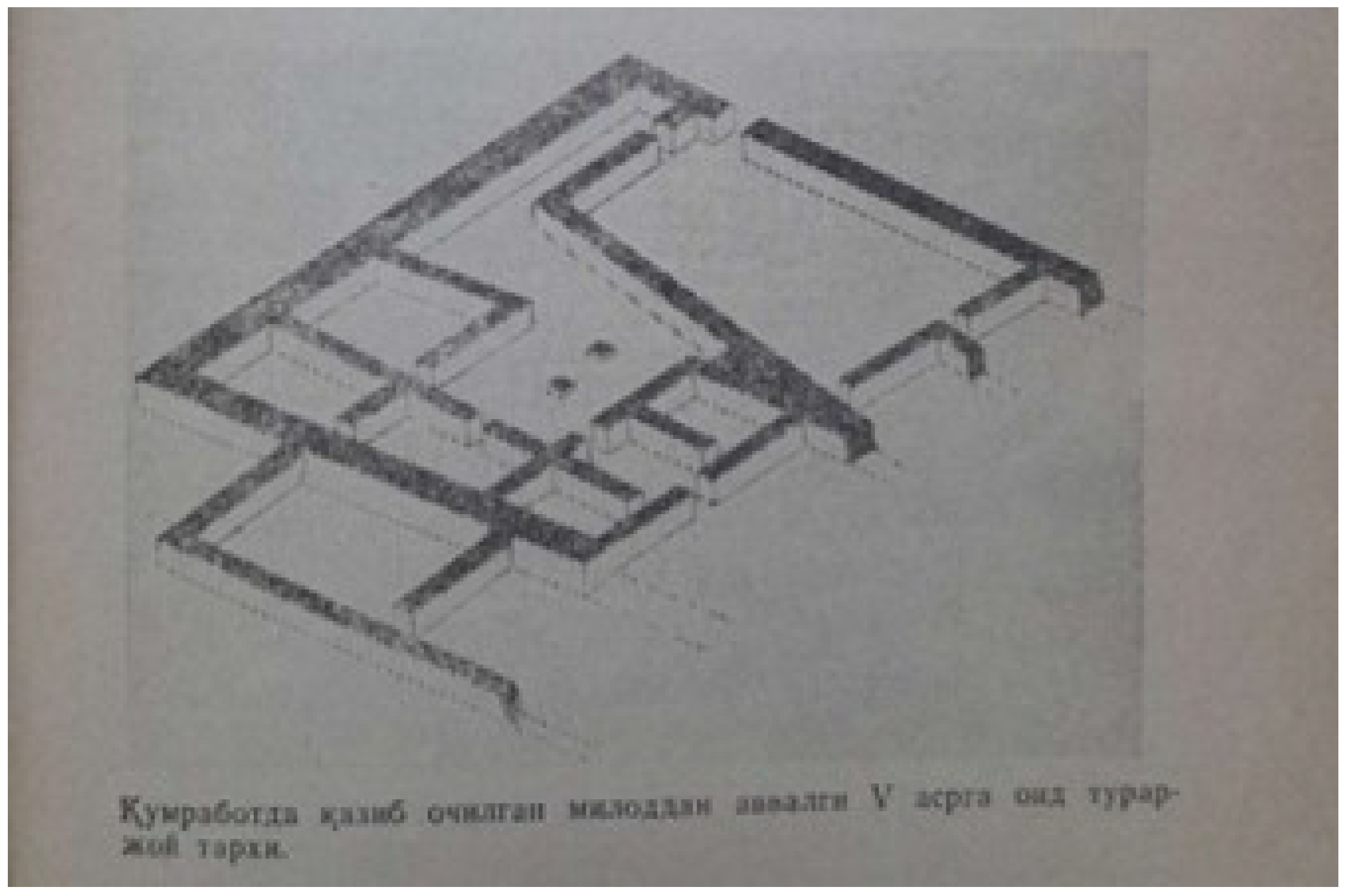
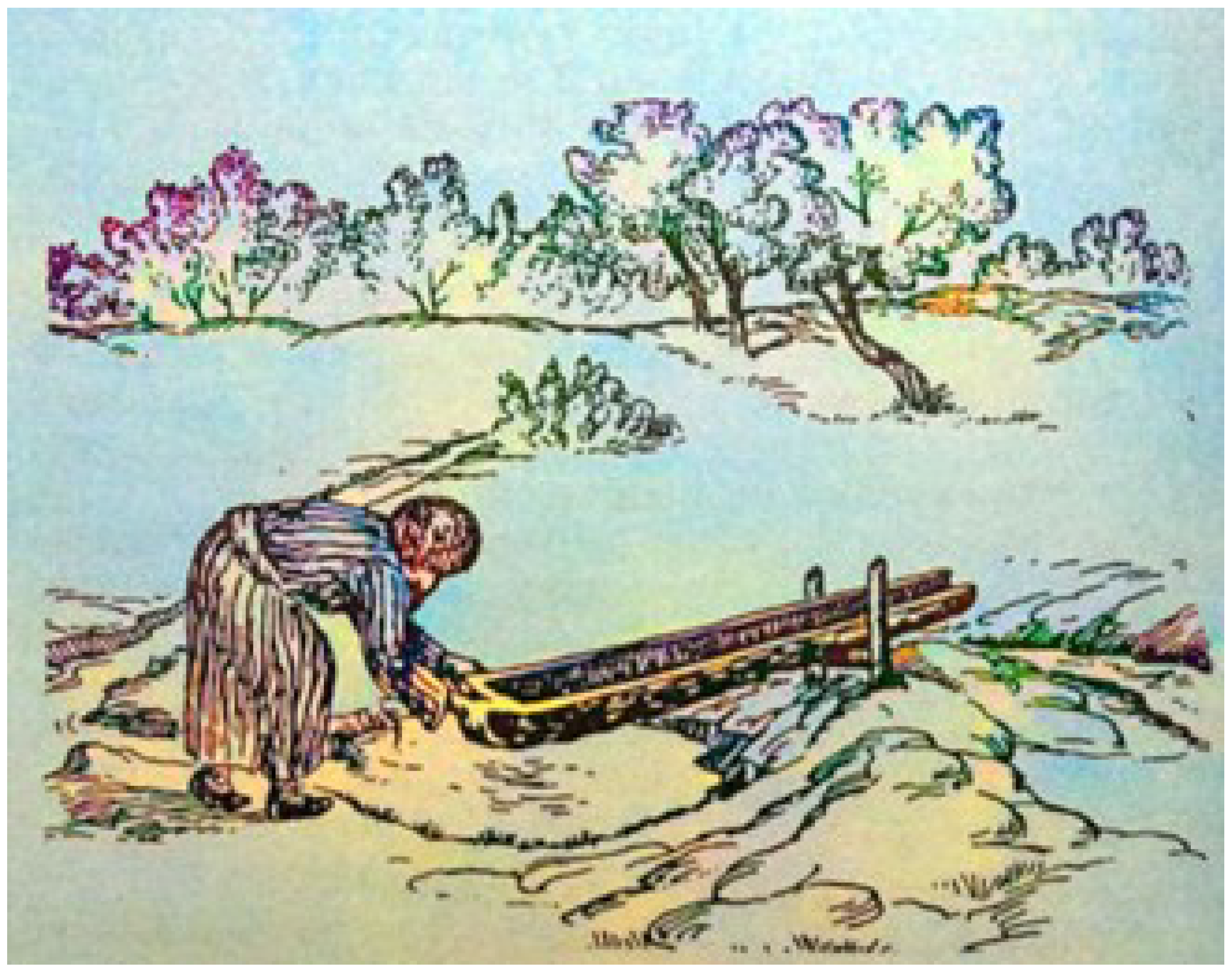
Figure 6.
Image of a farmer watering using a sepma device.
However, the main part of the oasis consisted of thickets and reeds. Because in this period, the Zarafshan waters were not used for farming in the Samarkand part of the valley, and its annual flow was widespread in the lands of Bukhara. Even at its foot (on the territory of the present-day Korakul and Olot districts), the famous "Borgini Farokh", i.e. "Ulkan" is described in the written sources of the early Middle Ages. "ash" was formed [1].
The process of the emergence of the oldest villages in the Bukhara oasis was described by the 10th century Bukhara historian Muhammad Narshahi: "At first they lived in tents and grass, then with the passage of time, people gathered and built buildings... The city of Bukhara did not come into being yet, some of them appeared [1]." but some appeared from the villages. The geographical conditions of the lands where farming villages belonging to the VI-V centuries BC, recorded and studied in the vicinity of Varakhsha and Konimekh, are reminiscent of the ancient landscape described by Narshakhi. In addition to historian Narshakhi, researcher Mugammadjonov also has the following opinion: almost all the ruins of Kishlok are located on the banks of river channels. Farming was more convenient in such lands near water. The ruins of such villages are especially well preserved in Kumrabot, Arabon-1, Arabon-2 and Chordara, 5 km west of Konimekh district [1].
As a result of careful examination of these monuments, including the ruins of the Kumrabot village, the first villages in Bukhara, especially in the north, were built, their history - the structure of their buildings, household life, especially handicrafts. This rare monument dating back to VI-V centuries BC is located south of Chordara, 0.5 km southwest of Kumrabot village. A part of the monument was demolished. The area of the preserved part of the ruins of the village is 45x50 meters, it consists of a large 9-room house, a courtyard and pottery workshops, and a strong fortress surrounded by a thick wall. The walls of the fort and building were made of straw, 1.2-2.2 m thick, and 0.6 m high. The pottery workshop is separate and is located on the eastern side of the fortress. It has a 1.1-meter-diameter two-burner hotplate for cooking pottery. Its top was broken and fell into the firebox. Historian Muhammadjonov said in his book that there were many thin-lipped, flat-flange, resonating bowls and cup-shaped, round-shaped ceramic vessels, and their fragments, made on the pottery wheel [1].
Chordara Hill, located 5 km west of the center of Nokhia, is especially interesting among the archeological monuments of Konimekh dating back to the VI-V centuries. Its area is 40x20 m, and its height is 11 m. The bottom layer of this high hill consists of the ruins of a fortified fortress made of straw and large raw bricks, 56 cm long, 28-30 cm wide, and 7-8 cm thick. Its outer wall and arched doorways in several rooms are still very well preserved [1]. Burial mounds of settled peasants who lived in the ancient Konimekh vokha were excavated near the villages of Shodibek and Kalkanota. Although most of the graves had already been dug up and the grave goods stolen, he nevertheless gave some information about the funeral rites of that time. Based on this information, we had the opportunity to think. Mazar mounds consist of tombs with flattened domes with a diameter of 7-18 m and a height of 0.5-1.5 m. The burial chamber is located in its center. It is rectangular, oval in shape. Size 2-2.2x 0.6-0.9 m, depth 0.4-0.6 m [2]. The dead were buried on their backs with their heads facing the northeast. Many of the male skeletons were found with stone stones with a hole in one side at the waist. In one of the graves, inside the skull, there was a three-bladed brass tube-shaped arrowhead, and from the second grave, only a jar-like container with a thin lip and a flat bottom was recorded. In spite of their smallness, these objects have been found in the Konimekh region [5,6], and they shed some light on the history of ancient villages and their culture.
In the following years, during the study of village ruins belonging to VI-V centuries recorded around Varakhsha, especially in the vicinity of Boshtepa located on the old bank of the Vobkent River on its western side, there is an opportunity to study the ancient ancestors and their development stages, and the existence of such monuments is undoubtedly important in the formation and development of the first urban culture in Bukhara. indicates that he played a role. That’s why Narshakhi writes about the most ancient villages built in the Bukhara region: "Varakhsha is one of the big villages…it is more ancient than the city of Bukhara [2]." Narshahi’s information is quite close to the truth, and it is confirmed to a certain extent by what was recorded in the layers of the ruins of the city of Varakhsha in 1975-1977. archeological findings below [3].
3. Result
Results; The analysis of the presented archaeological data shows that the primitive tribes who lived in the lower Zarafshan at the end of 2000 BC and the beginning of the first millennium BC belonged to the Andronov Tozabiogon culture [3]. As a result of continuous communication with the inhabitants of the steppes and valleys of Khorezm and Central Asia, they mixed with local farmers and herders and participated to some extent in the formation of the following ancient Sokht culture.Thus, in the Bukhara oasis, especially in its northern and northwestern parts, urbanized villages of the first urban type began to form in the sixth and fifth centuries BC. THey were fortified villages built of large raw bricks and straw, surrounded by a wall, which were quite different from the half-land fiber and light shepherd’s huts of the ancient home herdsman farmers. Served as the main foundation in construction. Issues of urbanization are always one of the most urgent problems in the socio-economic and cultural development of society, and the research of its history is considered one of the most important topics in science, therefore special attention has always been paid to this topic in the science of archeology [6]. A special archaeological expedition was organized under the leadership of Y. Gulomov in the 1960s in connection with the study of the history of the emergence of cities and the development of urban culture in the territory of our republic [7]. Archaeologists have started excavations in the ruins of the ancient cities of Kuva and Ahsikent in the Ferghana Valley, and in the ruins of Afrosiyab in Samarkand.
4. Discussion
It is natural to have the idea that the real body was kept in Bukhara. The materials found in the ruins were thoroughly re-examined. Excavations were carried out in several urban ruins found near the city of Bukhara. Archaeological research was started in the ancient Pogan ruins. As a result, the Pogan Varam proved to be older than Bukhara. It was determined that the end of the 4th century belongs to the third century. Although ceramic pieces dating back to the 5th and 4th centuries BC were found in the lower layer of the sheet, the 2-meter-thick old wall and the huge circular mouli, which were excavated from large-scale 40-27 raw heads, were found to belong to the early Romiton period. [8] and the ruins in the lower layers were found to belong to the third and fourth centuries AD, so the information of Narshakhi about the age of Bukhara and the ancient villages located around it was not confirmed in the archaeological findings. gave some clarity in restoring the general picture of the process of the city’s emergence, the real age of Bukhara was determined through archeological research.
5. Conclusions
Thus, in the Bukhara oasis, especially in its northern and northwestern parts, urbanized villages of the first urban type began to rise in BC and in the IV-V centuries. They were fortified villages surrounded by a wall, completely different from the semi-basement and light shepherd’s huts of the ancient cattle-breeding peasants. Undoubtedly, they served as the main foundation for the growth of urban culture in the oasis. Livestock farming has flourished in the lively Rometon Bukhara suburbs, and these areas have become a comfortable place for hunters and fishermen to become large pastures for the ancient cattle-breeding population of Bukhara. During the recent excavations, the ancient central part of Bukhara was located on the river bank east of the arch, which is much lower than the arch in terms of relief, with an area of 12-13 hectares. At a depth of 4 and a half meters, the remains of the ancient defensive wall of the city were noted. During the centuries it was built in the 5th and 6th centuries AD, it was repaired and restored several times. Therefore, it was divided over the centuries. In the early Middle Ages, a wide road passed along the river bank outside the ancient wall of Bukhara, which reached 17 meters in width. The southern gate of the city is located in the middle of the square between the minaret column and the Mir Arab Madrasah, during the excavations in the back, the remains of the Medina gate and the minaret were excavated. Along the main street that passed outside this gate, in the following centuries, the minaret of the Kalon Mosque, the Kolon Ulugbek Mirrarab Madrasah, the Abdulaziz Khan Madrasas, and the Taqizargoron were built. The process of the emergence of the oldest villages in the oasis of Bukhara was described by the century Bukhara historian Muhammedlar Shahi as follows: first they lived in tents and grass, then over time people gathered and built buildings. Bukhara historian Narshahi writes that it appeared. The geographical conditions of the agricultural villages of the 6th-5th centuries BC, recorded and studied in the vicinity of Varakhcha and Konimekh, remind of the ancient landscape described by Narshahi. Almost all of the village ruins are located on the banks of river channels, it is more convenient to farm in such lands near the water, such peasant ruins are especially well preserved in the areas of Qumrabot Arabon 1, Arabon 2 and CHordara, 5 km west of the end of Konimeh.
References
- Muhammadjonov A.A -Tashkent-1991 "Ancient Bukhara" (archaeological records and history).
- Muhammad Narshahi "Bukhoro historical" IX century.
- Urokova, D.Q.; Shoisoyev, I. HISTORICAL SAMARKAND IRRIGATION SYSTEMS. Conferencea 2022, 143–145. [Google Scholar]
- Shoisoyev, I. HISTORICAL SAMARKAND IRRIGATION SYSTEMS. Innovatsion research in the modern world: theory and practice 2022, 1, 38–40. [Google Scholar]
- Shoisaev, I.; Urokova, D. FORMATION PROCESSES OF TASHKENT OLD CITY NEIGHBORHOODS. Journal of PEDAGOGS 2022, 3, 67–76. [Google Scholar]
- Qodirovna, O.D.; Shoisoyev, R.; Kenjayevich, I. HISTORICAL SAMARKAND IRRIGATION SYSTEMS. Conferencea 2022, 143–145. [Google Scholar]
- Shoisoyev, I. HISTORICAL SAMARKAND IRRIGATION SYSTEMS. Innovatsion research in the modern world: theory and practice 2022, 1, 38–40. [Google Scholar]
- Urokova, D. SAMARKAND IRRIGATION SYSTEM. Academicia Globe: Interscience Research 2022, 3, 83–89. [Google Scholar]
- Bruno, Jacopo (2022)"Bukhara and its neighborhood. Reassessing the cultural links of the oasis from new ceramic evidence" Archaeological Research in Asia, publication number 31, 100372. [CrossRef]
Disclaimer/Publisher’s Note: The statements, opinions and data contained in all publications are solely those of the individual author(s) and contributor(s) and not of MDPI and/or the editor(s). MDPI and/or the editor(s) disclaim responsibility for any injury to people or property resulting from any ideas, methods, instructions or products referred to in the content. |
© 2024 by the authors. Licensee MDPI, Basel, Switzerland. This article is an open access article distributed under the terms and conditions of the Creative Commons Attribution (CC BY) license (http://creativecommons.org/licenses/by/4.0/).
Copyright: This open access article is published under a Creative Commons CC BY 4.0 license, which permit the free download, distribution, and reuse, provided that the author and preprint are cited in any reuse.


