
Submitted:
08 October 2023
Posted:
09 October 2023
You are already at the latest version
Abstract
Geotechnical investigation is an important site characterization process in engineering construction. Excavation pits and boreholes are popular geotechnical investigation methods for accessing subsurface soil and rock characteristics. Although they are accurate, they are limited to the discrete locations where tests are carried out. The demand for 3D representation has been increasing as an alternative for improved visualization of geotechnical investigations. This study developed a procedure for 3D modelling of geotechnical investigations using open-source software. It improves 3D visualization of geotechnical investigations and characterization of accuracy and uncertainty assessment. Presently, most geotechnical investigations do not regularly report uncertainty assessment despite its importance in risk analysis of the investigations. The procedure developed in this study was tested in a proposed site for construction of an Inland Container Depot where it depicted geotechnical soil properties with more than 80% accuracy on holdout samples. It was able to model both horizontal and vertical variations of the soil properties with quantification of uncertainty. More testing and wide applications are recommended.
Keywords:
3D modelling
; geotechnical properties
; spatial modelling
1. Introduction
Geotechnical investigation is an important site characterization process for identifying suitability of soil and rock as construction materials or foundation support for engineering structures. Excavated pits or boreholes are popularly used geotechnical investigation methods for characterizing vertical profile properties of soil, rocks, and other possible fill materials (Griffiths and Radford, 2012; Fowler and Weir, 2008; Hunt, 2007; Audibert and Huang, 2005). They are fundamental subsurface exploration techniques for uncovering buried soil and rock properties. They are also suitable alternatives for validating non-inversive methods such as remote sensing and geophysical sounding. However, most geotechnical investigations only consider few excavated pits or boreholes due to cost and time limitations especially where elaborate testing is required. The literature is not conclusive on the optimal number of excavated pits or boreholes in a project site (Crisp et al., 2020). Most geotechnical investigations use few excavated pits or boreholes with the tacit assumption that the selected discrete locations are representative enough for all areas in a project site. This approach does not consider associated uncertainties in unsampled locations and can result into increased risks to the construction projects due to inadequate geotechnical information. The objective of this study was to show how three-dimension (3D) modelling using open-source R software can be used to illustrate geotechnical investigation and improve site characterization with limited excavated pits or boreholes.
Excavated pits, trenches, or boreholes are used in geotechnical investigations to permit close assessment, sampling for further laboratory analyses, in-situ testing, and description of vertical profiles below the surface of the earth. Observations from these techniques are commonly collected and represented in one-dimensional (1D) borehole log ( Liu et al., 2023; Baluch et al., 2022; Bo, 2022; Look, 2007). Although 1D representation gives accurate geotechnical investigations at the sampled pit/borehole locations, it does not show proper indication of subsurface conditions in between sampled pits/boreholes. Adequate subsurface characterization of a construction site is better represented with a 3D than 1D viewpoint (Caballero et al., 2022; Zhang et al., 2020). 3D modelling gives more effective visualization and comprehension of the relationship between vertical and horizontal continuum of subsurface conditions than in 1D or 2D. Since geological and geotechnical sub-surfaces are inherently 3D, they are best portrayed with 3D representation (Masoud et al., 2022). Presently, there is scanty literature information on open-source software for 3D representation of geotechnical investigations. Limited literature show 3D representation of the geotechnical investigations (Aghamolaie et al., 2019; Kim et al., 2020; Vähäaho, 1998). This paper developed a routine for 3D modelling of geotechnical investigations using machine learning and open-source software to improve representation of investigations in geological and geotechnical engineering.
Soil and rock properties often investigated in geotechnical surveys include indices of strength (such as shear resistance, compressive strength, bearing capacity, cohesion, friction angle, etc.), consistency limits, grain-size composition, moisture, compaction, etc. These properties have spatial correlations that can be modelled with spatial statistics to portray a two-dimensional (2D) representation of geotechnical investigations (Balasubramani and Dodagoudar, 2022; Sotiropoulos et al., 2016; Cheon and Gilbert, 2014; Bardet and Zand, 2009). Recent advances in computing have improved application of spatial statistics in various ways that can benefit representation of geotechnical investigations. For example, machine learning algorithms, big data modelling, open-source computing environments, etc. have been shown to offer tremendous improvements in statistical modelling and can also be applied in geotechnical modelling (Phoon and Zhang, 2023; Verdu et al., 2023; Zhang et al., 2021; Tahmasebi et al., 2020). This study used these approaches in statistical modelling to develop a 3D model for geotechnical investigations.
3D modelling has been tested in many geotechnical investigations in various ways. Aghamolaie et al. (2019) used sequential gaussian simulation to develop 3D geological model for subsurface soil in Iran. They first developed spatial models of the geotechnical properties and then integrating the maps into a 3D model. This approach was also used by Kim et al. (2020) in Korea and Samui (2012) in India. There are also approaches that use stand-alone software to develop 3D models. Examples include Groundwater Modelling Systems software (Touch et al., 2014), Plaxis 3D (Hemeda, 2022), among others. This study developed open-source computer scripts for producing spatial maps of geotechnical properties and integrating the maps into a 3D representation of geotechnical investigations of a project site.
2. Materials and Methods
2.1. Study area
This study was carried out in Kibarani in Mombasa County in Kenya (Figure 1). It lies in the Makupa Creek in the Indian Ocean. Its project site was proposed for construction of an inland container depot. The site was previously used as municipal dumping site since the late 1980s. Municipal solid waste layer of about 8 m was first removed from the site before commencement of geotechnical investigations. Consequently, most topsoil layers had soft decayed solid waste mixed with soil.
The region where the study site is located is underlain with layered sandstone rocks that are oriented northwest. The sandstone layers dip at 30-33 degrees to the vertical. Near the shoreline, they are between 0-5 m below the surface and between 15 – 20 m below the surface away from the shoreline towards north of the study area.
2.2. Geotechnical investigation and secondary data collection
Geotechnical investigations were carried out by drilling georeferenced boreholes (Figure 1) and carrying out in-situ testing (Standard Penetrometer Test (SPT) and vane shear test) and sampling for laboratory analysis of Atterberg limits (liquid and plastic limits). The tests and sampling were carried out on soil material at irregular depth intervals up to the rock restriction. SPT was carried out according to ASTM D1586/D1586M-18e1 and vane shear test according to ASTM D2573-08 standards. Samples for laboratory analyses were collected using the split barrel on the SPT equipment (Hunt, 2007). Liquid limit (LL) and plastic limit (PL) tests were done according to ASTM D4318. SPT test produced number of blows (SPT-N) to push the rod to penetrate 15 cm into the soil, vane shear test produced undrained shear resistance in kN/m2, and Atterberg limits test produced liquid and plastic limits (Table 1).
In addition to in-situ testing and sampling, the study also collected topographic and remote sensing data for machine learning spatial analysis of the geotechnical soil properties. Topographic data was a 12.5 m Advanced Land Observing Satellite Digital Elevation Model (DEM) Phased Array type L-band Synthetic Aperture Radar (ALOS/PALSAR) developed by Alaska Satellite Facility (ASF) (https://asf.alaska.edu/, accessed on 20 August 2023) (ASF DAAC, 2014). Remote sensing data were multispectral Sentinel 2A images of the study site. The images were also downloaded from Alaska Satellite Facility (https://asf.alaska.edu/, accessed on 20 August 2023). Average images between January 2016 and December 2020 were used to cover the period when the geotechnical investigations were carried out and when Mombasa County waste management had significant changes (Wekisa and Majale, 2020). Level 2 DEM and remote sensing images, which had been corrected and processed, were used in this study.
2.3. Modelling geotechnical soil properties
2D representation of geotechnical investigations was developed to show spatial distribution of the target geotechnical properties in the project site. It was also the main input for the 3D model (Figure 2).
Depth harmonization was included to ensure that the 2D maps of geotechnical properties portrayed uniform depth intervals for all observation boreholes. Uniform depth intervals are particularly important where irregular sampling depths have been used in the soil profile characterization (Bishop et al., 1999; Ponce-Hernandez et al., 1986). Depth-integrated equal area splines were used to harmonize the depths at 0-1, 1-2.5, 2.5-5, 5-10, 10-15, 15-25, 25-35 m from the surface. These depth intervals were deemed adequate for site characterization (Hunt, 2007).
Equation (1) was used to harmonize different depth intervals into uniform depths.
where Ax is the harmonized geotechnical property at x uniform depth interval (between xo and xn depths), xo is the upper soil depth, xn is the lower soil depth, n is the number of depth intervals, λ is weighting factor, and f is a spline function to estimate the geotechnical property. Scripts were written in R software to implement Equation (1).
Spatial modelling was done using machine learning with topographic and remote sensing data as environmental covariates. Machine learning and artificial intelligence have recently been embraced in mapping spatial distribution of geotechnical properties (Li et al., 2022; Zhang et al., 2021; Puri et al., 2018). In this study, different machine learning algorithms were first evaluated to select the appropriate model for 2D modelling. The evaluation was based on models with least root mean square error (RMSE) and bias and highest Nash-Sutcliffe coefficient of efficiency (NSE) and correlation (r2) (Gupta et al., 2009). Uncertainty assessment of the spatial modelling was done using bootstrapping approach while accuracy assessment was done using bias, RMSE, r2, and NSE. Graphical illustration of the modelled versus harmonized geotechnical properties was also used to enhance the accuracy assessment. Finally, 3D solid model for the geotechnical investigation was developed by integrating different 2D spatial layers. The thickness of each layer was obtained from the depth harmonization.
3. Results
3.1. Measured geotechnical properties
Measured geotechnical properties showed a pattern of increasing stiffness and hardness of soil down the profile (Figure 3). This was expected because the lower layers of soil are often compacted by the overburden top layers. Furthermore, top layers were also expected to be soft owing to the previous use of land as a damping site. The spatial distribution in Figure 3 also portrayed more strong and hard soil in the north and northwest of the study area. In Figure 1, north and northwest of the project site had the highest altitude and could have had more weathered rocks and deep soil than the undulating and shallow central and eastern parts. Remote sensing images also showed sparse trees growing in these areas compared to central and eastern parts which were mainly covered with dumped solid wastes.
3.2. Modelling geotechnical properties
Evaluation of machine learning algorithms for spatial modelling of the geotechnical soil properties showed that quantile random forest was the best algorithm for modelling SPT, LL, PL and resistance (Table 2). It had the lowest RMSE and bias and the highest r2 and NSE. Hence, the algorithm was used in developing spatial distribution of the geotechnical properties at harmonized soil depths.
Spatial distribution of the geotechnical properties showed that the modelled spatial pattern mirrored actual observations at the sampling points (Figure 4). It also depicted higher uncertainties in the lower soil depths than upper layers. This was partly because of the variation in overall soil depths, which conditioned geotechnical properties. This variation was possibly caused by impacts of different damping waste materials over the years (Wekisa and Majale, 2020). It also showed that areas with low distribution of sampling points had higher modelling uncertainties. They could be earmarked for more sampling to improve spatial information of the geotechnical properties.
Layers of 2D distribution at uniform depth intervals were integrated into 3D model. The 3D model showed variation of the geotechnical properties horizontally across the landscape and vertically down the profile in one graphical illustration (Figure 5). It showed that the north and northwest of the study area and the southern tip had stronger soil layers than the central and eastern parts (Figure 5). It also depicted increasing soil strength and stiffness down the profile. This pattern reflected borehole observations albeit in 3D representation.
4. Discussions
Most engineering reports of geotechnical investigations portray geotechnical properties in 2D format. This format is influenced by the 2D borehole logs for data collection. Although the logs portray accurate information at the sampling site, they may be biased in representing unsampled locations. 3D model is best suited in tackling inherent complex subsurface ground conditions in one graphical representation. Figure 5 is an example of the 3D model that captures both spatially exhaustive horizontal and vertical geotechnical characteristics in one illustration. In one snapshot, the model shows suitable areas for construction of desired structures and unsuitable areas that may require geotechnical modification or removal before construction of structures.
The approach for developing 3D model for geotechnical investigation in this study involved depth harmonization of borehole logs, spatial distribution of harmonized borehole logs, and final integration of 2D spatial maps into a 3D model. The use of borehole logs as input into the modelling ensures accuracy. Although they are cumbersome and are only limited to discrete locations in a project site, borehole observations are considered more accurate than other investigation techniques (Soupios et al., 2007). Integration of borehole logs with spatial modelling serves to improve on some of the limitations of the borehole observations and improves geotechnical information during investigation. Further information improvement is achieved by quantification of uncertainties (Figure 4) which are otherwise lacking in most geotechnical investigations.
The approach developed in this study can be used with existing geotechnical investigation databases to improve information characterization of complex subsurface conditions that are not well covered by borehole observations alone. This approach has been tried in the literature albeit without the rigour of accuracy and uncertainty assessment and machine learning (Masoud et al., 2022). Accuracy and uncertainty assessments can help to target specific locations that need further borehole observations.
5. Conclusions
This study developed a routine for 3D representation of geotechnical investigations in one graphical illustration. The routine uses open-source software to integrate pit/borehole logs, topographic and geologic information, and spatial modelling to produce a 3D model of geotechnical properties for a project site. The routine improves 3D visualization of geotechnical investigations and characterization of accuracy and uncertainty assessment which are hitherto not regularly mentioned in geotechnical investigations. It also uses machine learning for spatial modelling technique to improve 2D characterization of geotechnical properties from discrete borehole observations. Machine learning is a powerful tool for mapping earth resources but has not been popularly accommodated in geotechnical investigations. In this study, machine learning algorithms were found to have higher predictive performance than other spatial modelling algorithms. Their integration into the 3D modelling approach is expected to reduce some of the uncertainties in geotechnical investigations.
The study tested limited geotechnical soil properties. More testing and wide applications are recommended to improve the approach.
Author Contributions
For research articles with several authors, a short paragraph specifying their individual contributions must be provided. The following statements should be used “Conceptualization, methodology, software development, validation, writing—original draft preparation, Festus Ngeno; writing—review and editing, Christian Omuto; supervision, Elijah Biamah. All authors have read and agreed to the published version of the manuscript.
Funding
This research received no external funding.
Data Availability Statement
The datasets generated during the current study are available from the corresponding author on reasonable request.
Acknowledgments
This study used data from geotechnical investigations of proposed Inland Container Depot at Kibarani in Mombasa. The staff involved in data collection are highly acknowledged. Remote sensing data and elevation were downloaded from https://sentinels.copernicus.eu/web/sentinel/home and https://asf.alaska.edu/.
Conflicts of Interest
The authors declare no conflict of interest.
References
- Aghamolaie, I. , Lashkaripour, G.R., Ghafoori, M., Hafezi Moghaddas, N., 2019. 3D geotechnical modeling of subsurface soils in Kerman city, southeast Iran. Bulletin of Engineering Geology and the Environment, 78, 1385–1400. [CrossRef]
- ASF DAAC, 2014. PALSAR Radiometric Terrain Corrected Low Resolution. [CrossRef]
- Audibert, J.M. , Huang, J., 2005. Geophysical and Geotechnical Design, in: Handbook of Offshore Engineering. Elsevier, pp. 1145–1268. [CrossRef]
- Balasubramani, D.P. , Dodagoudar, G.R., 2022. Modelling the spatial variability of Standard Penetration Test data for Chennai City using kriging and product-sum model. Geomechanics and Geoengineering, 17, 92–105. [CrossRef]
- Baluch, K. , Kim, Jung-Gyu, Kim, Jong-Gwan, Ko, Y.H., Jung, S.-W., Baluch, S.Q., 2022. Assessment of sinkholes investigations in Jangseong-Gun Area, South Korea, and recommendations for similar studies. Int. J. Environmental Research and Public Health, 19, 1111. [CrossRef]
- Bardet, J.-P. , Zand, A., 2009. Spatial modeling of geotechnical information using GML. Transactions in GIS, 13, 125–165. [CrossRef]
- Bishop, T.F.A. , McBratney, A.B., Laslett, G.M., 1999. Modelling soil attribute depth functions with equal-area quadratic smoothing splines. Geoderma 91, 27–45. [CrossRef]
- Bo, M.W. , 2022. Geotechnical Ground Investigation. World Scientific Publishing, Singapore, 268 p. [CrossRef]
- Caballero, S.R. , Bheemasetti, T.V., Puppala, A.J., Chakraborty, S., 2022. Geotechnical visualization and three-dimensional geostatistics modeling of highly variable soils of a hydraulic fill dam. Journal of Geotechnical and Geoenvironmental Engineering, 148, 05022006. [CrossRef]
- Cheon, J.Y. , Gilbert, R.B., 2014. Modeling spatial variability in offshore geotechnical properties for reliability-based foundation design. Structural Safety, 49, 18–26. [CrossRef]
- Crisp, M.P. , Jaksa, M., Kuo, Y., 2020, Optimal testing locations in geotechnical site investigations through the application of a genetic algorithm. Geosciences, 10, 265. [CrossRef]
- Fowler, M. , Weir, F., 2008. The use of borehole breakout for geotechnical investigation of an open pit mine, in: Proceedings of the First Southern Hemisphere International Rock Mechanics Symposium. Presented at the First Southern Hemisphere International Rock Mechanics Symposium, Australian Centre for Geomechanics, Perth, pp. 541–550. [CrossRef]
- Griffiths, J.S. , Radford, T., 2012. An introduction to earthworks in Europe. Geological Society, London, Engineering Geology Special Publications, 26, 1–4. [CrossRef]
- Gupta, H.V. , Kling, H., Yilmaz, K.K., Martinez, G.F., 2009. Decomposition of the mean squared error and NSE performance criteria: Implications for improving hydrological modelling. Journal of Hydrology, 377, 80–91. [CrossRef]
- Hemeda, S. , 2022. Geotechnical modelling and subsurface analysis of complex underground structures using PLAXIS 3D. International Journal of Geo-Engineering, 13, 9. [CrossRef]
- Hunt, R.E. , 2007. Geotechnical Investigation Methods: A Field Guide for Geotechnical Engineers. CRC/Taylor & Francis, Boca Raton, FL, 353 p.
- Kim, M. , Kim, H.-S., Chung, C.-K., 2020. A three-dimensional geotechnical spatial modeling method for borehole dataset using optimization of geostatistical approaches. KSCE Journal of Civil Engineering, 24, 778–793. [CrossRef]
- Li, Y. , Rahardjo, H., Satyanaga, A., Rangarajan, S., Lee, D.T.-T., 2022. Soil database development with the application of machine learning methods in soil properties prediction. Engineering Geology, 306, 106769. [CrossRef]
- Liu, Y. , Ng, Y.C.H., Zhang, Y., Yang, P., Ku, T., 2023. Incorporating geotechnical and geophysical investigations for underground obstruction detection: A case study. Underground Space, 11, 116–129. [CrossRef]
- Look, B.G. , 2007. Handbook of Geotechnical Investigation and Design Tables, 0 ed. Taylor & Francis, London, 348 p. [CrossRef]
- Masoud, A.A. , Saad, A.M., El Shafaey, O.N.H., 2022. Geotechnical database building and 3D modeling of the soil in Medina, Saudi Arabia. Arabian Journal of Geosciences. 15, 506. [CrossRef]
- Phoon, K.-K. , Zhang, W., 2023. Future of machine learning in geotechnics. Georisk Assess. Manag. Risk Eng. Syst. Geohazards, 17, 7–22. [CrossRef]
- Ponce-Hernandez, R. , Marriott, F.H.C., Beckett, P.H.T., 1986. An improved method for reconstructing a soil profile from analyses of a small number of samples. Journal of Soil Sciences, 37, 455–467. [CrossRef]
- Puri, N. , Prasad, H.D., Jain, A., 2018. Prediction of geotechnical parameters using machine learning techniques. Procedia Computer Science, 125, 509–517. [CrossRef]
- Samui, P. , 2012. Three-dimensional site characterization model of Bangalore using support vector machine. ISRN Soil Science, 2012, 1–10. [CrossRef]
- Sotiropoulos, N. , Benardos, A., Mavrikos, A., 2016. Spatial modelling for the assessment of geotechnical parameters. Procedia Engineering, 165, 334–342. [CrossRef]
- Soupios, P.M. , Georgakopoulos, P., Papadopoulos, N., Saltas, V., Andreadakis, A., Vallianatos, F., Sarris, A., Makris, J.P., 2007. Use of engineering geophysics to investigate a site for a building foundation. Journal of Geophysics and Engineering, 4, 94–103. [CrossRef]
- Tahmasebi, P. , Kamrava, S., Bai, T., Sahimi, M., 2020. Machine learning in geo- and environmental sciences: From small to large scale. Advances in Water Resources, 142, 103619. [CrossRef]
- Touch, S. , Likitlersuang, S., Pipatpongsa, T., 2014. 3D geological modelling and geotechnical characteristics of Phnom Penh subsoils in Cambodia. Engineering Geology, 178, 58–69. [CrossRef]
- Vähäaho, I. , 1998. From geotechnical maps to three-dimensional models. Tunnelling and Underground Space Technology, 13, 51–56. [CrossRef]
- Verdu, E. , Nieto, Y.V., Saleem, N., 2023. Big data and artificial intelligence in earth science: recent progress and future advancements. Acta Geophysica, 71, 1373–1375. [CrossRef]
- Wekisa, E. , Majale, C., 2020. Spatial distribution of waste collection points and their implications on quality of life in Mombasa County, Kenya. Journal of Urban Management, 9, 250–260. [CrossRef]
- Zhang, W. , Li, H., Li, Y., Liu, H., Chen, Y., Ding, X., 2021. Application of deep learning algorithms in geotechnical engineering: a short critical review. Artificial Intelligence Review, 54, 5633–5673. [CrossRef]
- Zhang, X. , Zhang, Y., Xu, L., Zhang, J., Tian, Y., Wang, S., Li, Z., 2020. Urban Geological 3D Modeling Based on Papery Borehole Log. ISPRS International Journal of Geo-Information, 9, 389. [CrossRef]
Figure 1.
Study area.
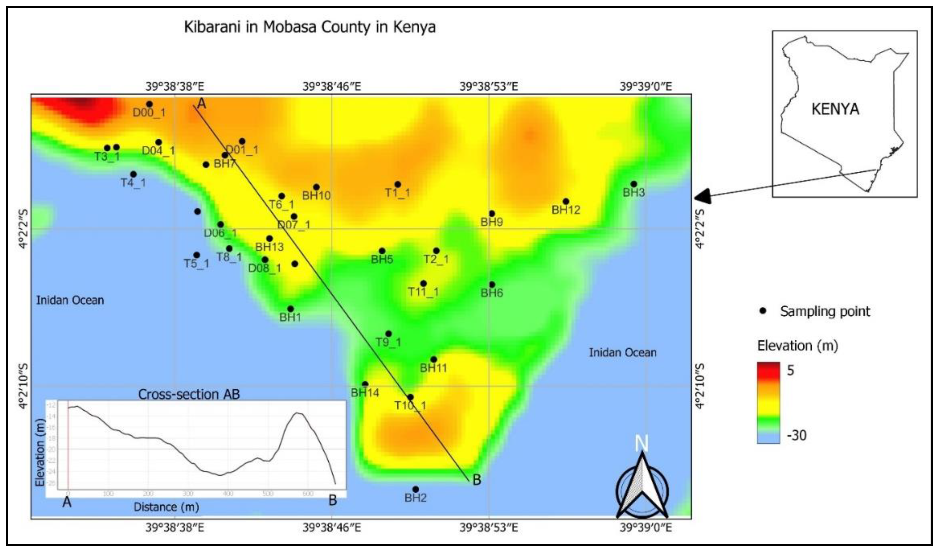
Figure 2.
Conceptual framework for routine for 3D representation of geotechnical investigations.
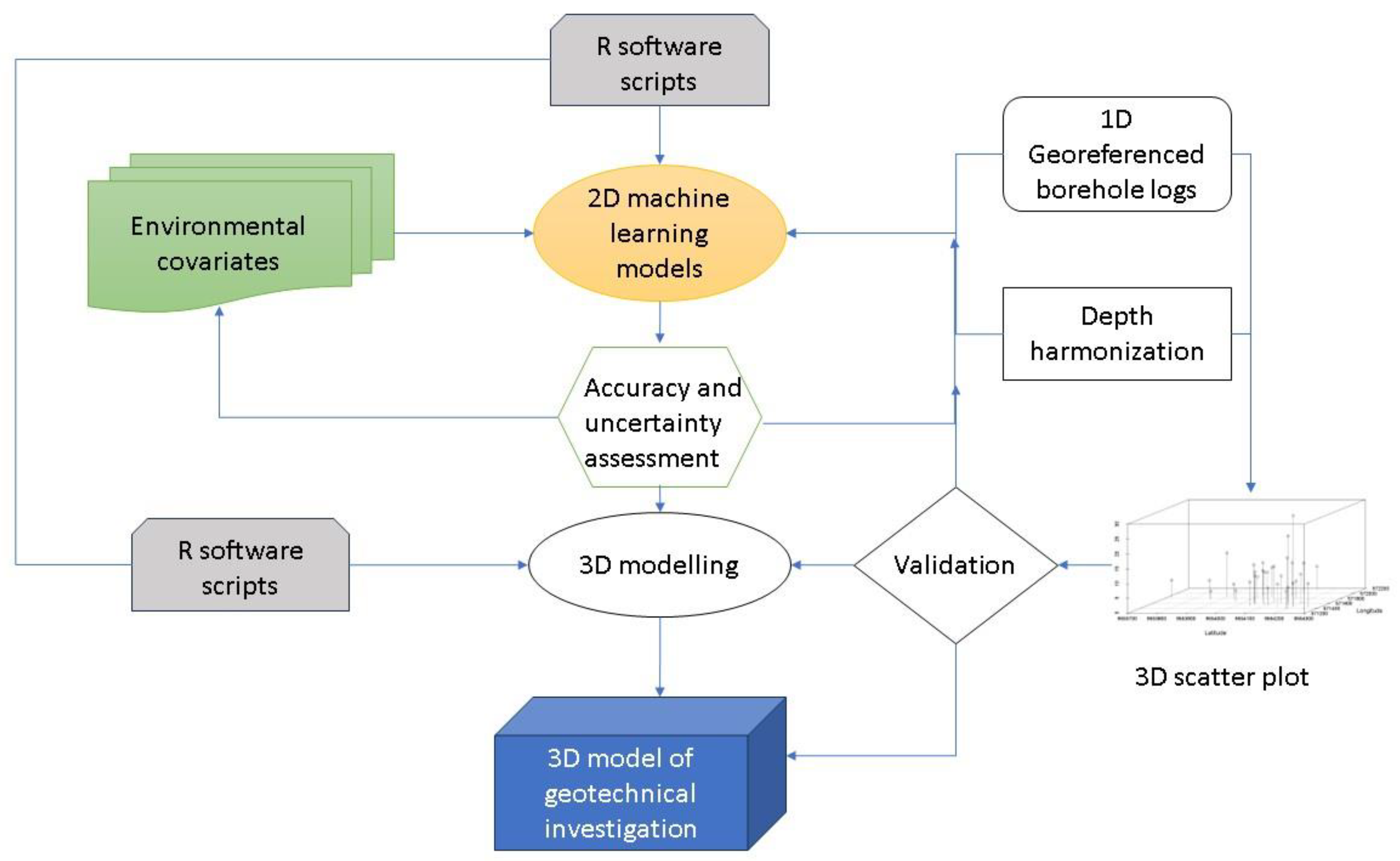
Figure 3.
Spatial distribution of geotechnical properties at borehole points.
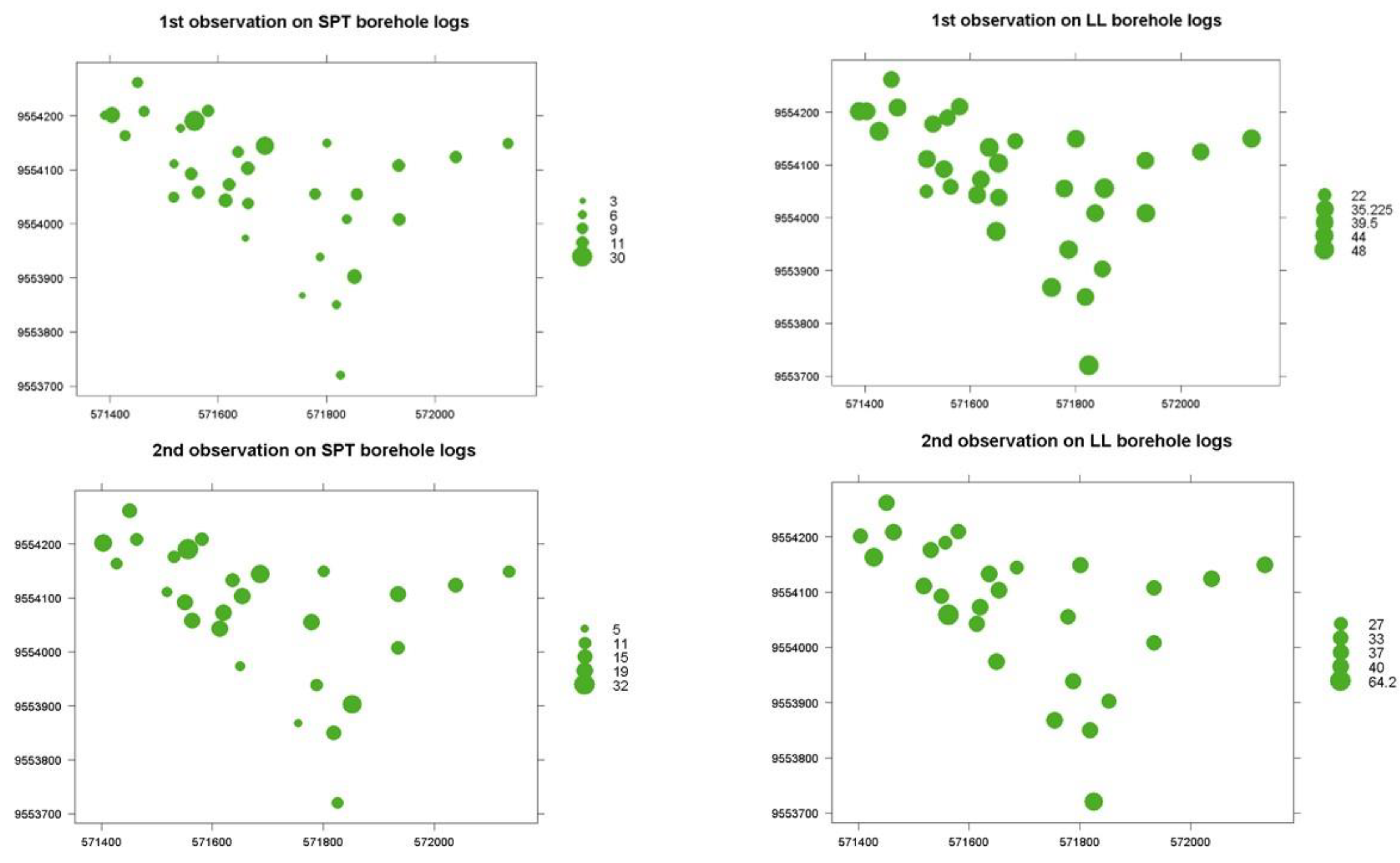
Figure 4.
Example of spatial modelling of geotechnical properties.

Figure 5.
3D model representation of SPT-N counts.
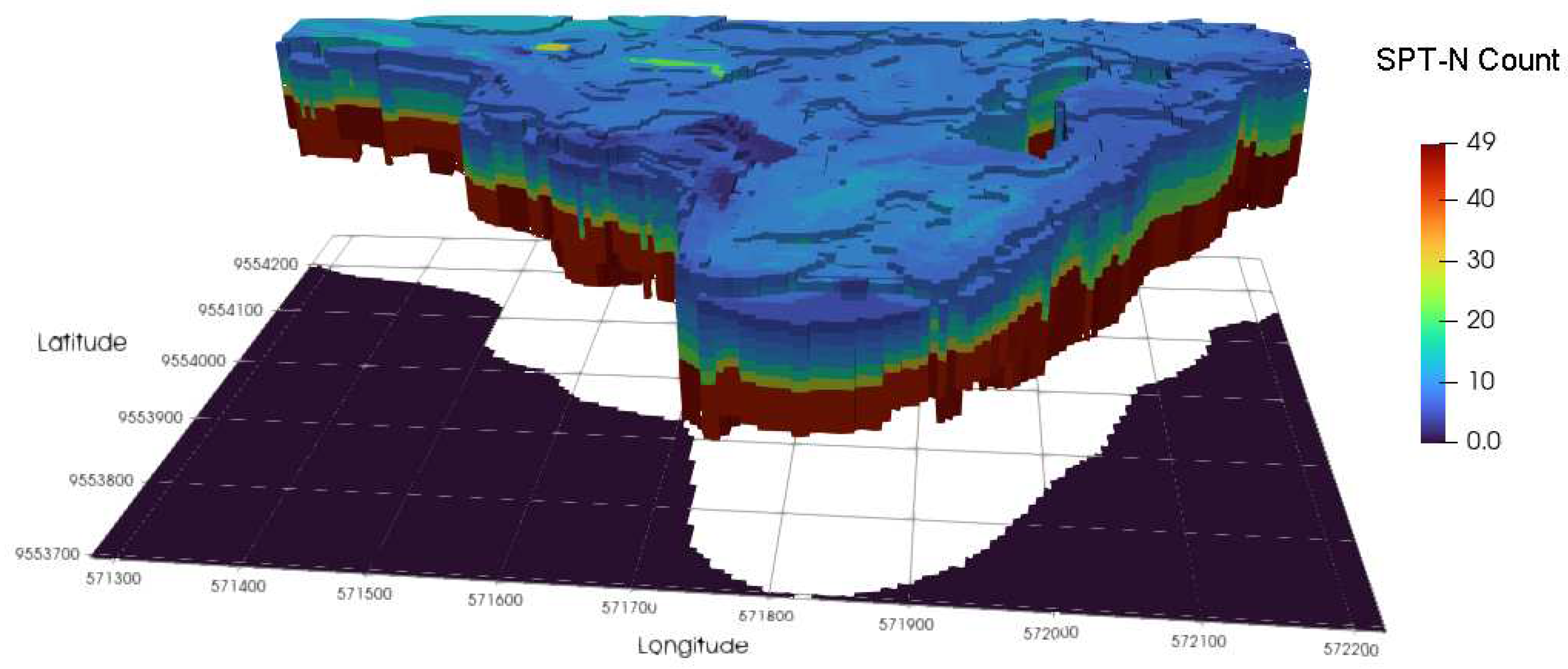

Table 1.
Range of values of soil properties from geotechnical site investigation.
| No. | Depth (m) |
SPT-N (blows) |
Resistance (kN/m2) | Liquid limit (LL) (%) | Plastic limit (PL) (%) |
|---|---|---|---|---|---|
| 1 | 1 - 11 | 3 - 30 | 33 - 101 | 22 - 48 | 13.6 - 34.7 |
| 2 | 2.5 - 13.6 | 5 - 32 | 38 - 121 | 27 - 64.2 | 12 - 33.9 |
| 3 | 4.5 - 22 | 5 - 32 | 38 - 133 | 27 - 50 | 12 - 33.9 |
| 4 | 10 - 28 | 15 - 37 | 45 - 189 | 25 - 44 | 13 - 30 |
Table 2.
Evaluation of machine learning algorithms for spatial modelling of geotechnical soil properties.
Table 2.
Evaluation of machine learning algorithms for spatial modelling of geotechnical soil properties.
| Machine learning/ regression algorithm | Evaluation statistics | |||
|---|---|---|---|---|
| ME | RMSE | r2 | NSE | |
| Linear regression | 0.342 | 0.483 | 0.479 | 0.166 |
| RandomForest | 0.112 | 0.215 | 0.869 | 0.992 |
| SVM | 0.297 | 0.488 | 0.457 | -0.032 |
| BayesianGLM | 0.388 | 0.565 | 0.330 | 0.152 |
| BaggedCART | 0.295 | 0.376 | 0.715 | 0.807 |
| Cubist | 0.078 | 0.215 | 0.816 | 1.000 |
| CART | 0.456 | 0.580 | 0.284 | -0.032 |
| Ranger | 0.114 | 0.169 | 0.948 | 0.995 |
| QuantRandForest | 0.023 | 0.092 | 0.962 | 0.996 |
| QuantNeuralNT | 0.222 | 0.641 | 0.622 | 0.013 |
Disclaimer/Publisher’s Note: The statements, opinions and data contained in all publications are solely those of the individual author(s) and contributor(s) and not of MDPI and/or the editor(s). MDPI and/or the editor(s) disclaim responsibility for any injury to people or property resulting from any ideas, methods, instructions or products referred to in the content. |
© 2023 by the authors. Licensee MDPI, Basel, Switzerland. This article is an open access article distributed under the terms and conditions of the Creative Commons Attribution (CC BY) license (https://creativecommons.org/licenses/by/4.0/).
Copyright: This open access article is published under a Creative Commons CC BY 4.0 license, which permit the free download, distribution, and reuse, provided that the author and preprint are cited in any reuse.


