Submitted:
15 August 2023
Posted:
16 August 2023
Read the latest preprint version here
Abstract
This article examines evolution of trans-regional Ethio-Djibouti railway corridor and its impact on urbanization. Exploratory and descriptive research methods were employed to examine the impact of this railway corridor. Case study also applied to examine eight selected intermediate cities. The article points out that, the Ethio-Djibouti railway corridor conceived different kinds of linear urban centers ranging from small towns to intermediate cities around stations. Those urban centers have been attracting industries along their fringes that leads to rural urban continuum ribbon urbanization. As the old railway line deteriorated, these linear urban centers on the railway corridor had also been declining from time to time. In 2011 new project was started to construct the Ethi-Djibouti standard gauge railway parallel to the old railway line. This new standard gauge railway infrastructure adopts ‘peripheral station’ development approach, which provides a room for width expansion for station based urban centers. It also attracts industries in a form of special economic zones, which causes for labour migration from rural and nearby small urban centers that caused rural-urban continuum of ribbon settlement; strengthen trade gate way for the landlocked Ethiopia that caused trans-regional integration.
Keywords:
industrialization
; intermediate cities
; urbanization
; railway station
; railway corridor
; regional integration
1. Introduction
Urban development is highly path-dependent usually, it evolved on river banks, coastal lines, and terrestrial transportation lines [1,2]. Railway is one of terrestrial transportation systems that cause for the flourishing of urban centers. In Ethiopia, modern railway transport was introduced during the reign of Emperor Menelik II (1888 – 1913) [3,4]. The advent of the railway infrastructure caused for the flourishing of the eastern economic corridor. This railway-corridor development results the flourishing of different levels of urban centers ranging from small towns to intermediate cities; establishment of industrial plants in the vicinity of railway stations; inflow of migrant people from rural to newly flourishing railway station based monocentric urban centers; inter and intra trade linkages among regional states etc.
However, there is seldom scientific research, which examines the role of this railway corridor from the regional and urban planning vantage points. There are few researches that addresses its historical development and economic benefit of the railway line [4,5,6,7]; but none of them addressed the railway corridor impact on urban and/or regional development.
Therefore, the purpose of this article is to examine the role of railway infrastructure corridor development for city formation that evolves from monocentric station towns to intermediate cities; industrialization through special economic zone development in a form of industrial parks; and regional integration as urban-rural linkages as well as inter-regional and trans-regional linkages.
2. Material and Methods
2.1. Description of the Study Area
Ethiopia is a least developed landlocked sovereign country that lays in the Horn of Africa neighbored with Eretria in the north, Djibouti in the northeast, Somalia in the east and south, Kenya in the south, South Sudan in the west and Sudan in the north-west. The total land mass of Ethiopia is 1.14 million Sq. Km. With a population of greater than 126 million, Ethiopia is the second most populated nation in Africa next to Nigeria [8]. The existing functional railway corridor being examined is located in the eastern direction of Ethiopia. The eastern railway corridor stretched from the central part of Ethiopia to the port of Djibouti.

Figure 1.
The Old and New Ethio-Djibouti Railway Line; Source:[9].
Figure 1.
The Old and New Ethio-Djibouti Railway Line; Source:[9].
This article also addressed urban centers that evolved from monocentric station based linear city to secondary or intermediate cities as well as industrial parks along with these railway corridors.
2.2. Methodology
The article mainly employed exploratory research methodology to search the literature and talk with experts on the historical development of the railway corridor development and its role for urbanization, industrialization and regional integration [10]. To gather primary data about old and new railway line development opensource satellite images, field observation, key informant interview, prefeasibility study of the new standard gauge railway infrastructure and other related legal documents. Data from the field were collected to assess the morphological traits of railway stations.
Secondary data were also used to support the primary data and describe the railway corridor development and its urban and regional impacts in the study area. The basic data and their respective sources are presented below. The study mainly focused on the description of the state of affairs as it exists in the past and at present as well as the prospect impact of the railway corridor on urbanization, industrialization and regional integration. [11].
2.3. Case Study
The article specifically examines intermediate urban centers from the vantage points of railway corridor impacts on urban dynamics, industrialization, and regional integration. In order to select intermediate cities, the article followed two stage analysis. First the article reviews the existing legal documents on the notion and nature of urban centers as well as intermediate city. Then selection criteria were set to determine railway station based intermediate cities using enforceable legal documents, MoUI reports and CSS data.
3. Results and Discussions
3.1. The Notion and Nature of Urban Center
Urban centers are politically defined administrative with delineated spatial units [12]. This definition entertained heterogeneously in different countries. For instance, in Germany urban centers refers as municipalities with municipal law and a population of greater than 2000 dwellers; in Iceland solely 200 inhabitants in a defined territory suffice for urban center; on the other hand, in Switzerland and Japan the minimum population requirement are 10,000 and 50,000 respectively [12]. Other countries also used additional criteria like density, economic activity etc. Similarly, the academia world also used different definitions for urban center as a spatial phenomenon. For example, Ecologist Erskine (1992) and Odum (1997) defined urban as built-up area and area that consume at minimum of 100,000 kcal/m2 per year respectively [12]. Planner Hendrix et al. (1988) define urban as areas with a population density of >100 inhabitants per acre, including commercial areas, highways and public facilities. The US bureau of census and UN define urban using population parameter as ‘area with > 2500 inhabitants and 20,000 inhabitants’ respectively [12].
The Ethiopia approach of urban definition seems transplanted from the German legal system. Similar to the Germen legal system, Ethiopian followed statutory definition to give recognition for urban center [13,14]. Article 2(8) of the planning law define ‘urban center’ as ‘any locality with established municipality or having a population size of 2000 or above inhabitants, of which 50% of its labor force is primarily engaged in non-agricultural activities [14]. On the other hand, the ‘Urban Landholding Registration Proclamation’ define ‘urban center’ as ‘any locality having a municipal administration or designated as an urban center by legally authorized body’ [13]. Therefore, population, economic activity and administrative/political decision are determinant factors to consider an area as urban center.
3.2. Intermediate City
The word ‘intermediary’ was first introduced in the academia world in the mid-1980s, which resembles medium-size city’ [15]. There are many different viewpoints about intermediate city. Some countries interchangeably used intermediate or middle-size city and secondary city, as a category of intermediate city [16]. UCLG, define ‘intermediary urban center’ using the elements of specific demographic size and the functions they perform, such as: their role in mediating flows of goods, information, innovations and administration, etc. between rural and urban areas, within the respective areas of influence and with respect to other urban centers or regions, which may be close to them or more distant [15].
Ethiopia used the term intermediate city and secondary city interchangeably, since 2005 with the approval of national urban policy [16]. The MoUI, considered urban agglomerations having greater than 20,000 inhabitants as intermediate or secondary or major city [17].
Based on the 2022 year CSS population projection of Ethiopian urban centers, and the above analysis one can conclude that, all station based urban centers fulfilled the planning law requirement of having 2000 and above inhabitants except Mulo. However, solely eight urban centers feats the minimum threshold of intermediate city (MTIC) requirement i.e., > 20,000 inhabitants [17]. Therefore, this article selected eight urban centers, namely: Bishoftu/Debre Zeyit, Mojo, Adama/Nazret, Welenchiti, Metehara, Awash Sebat Kilo, Mieso and Dire Dawa as case study.
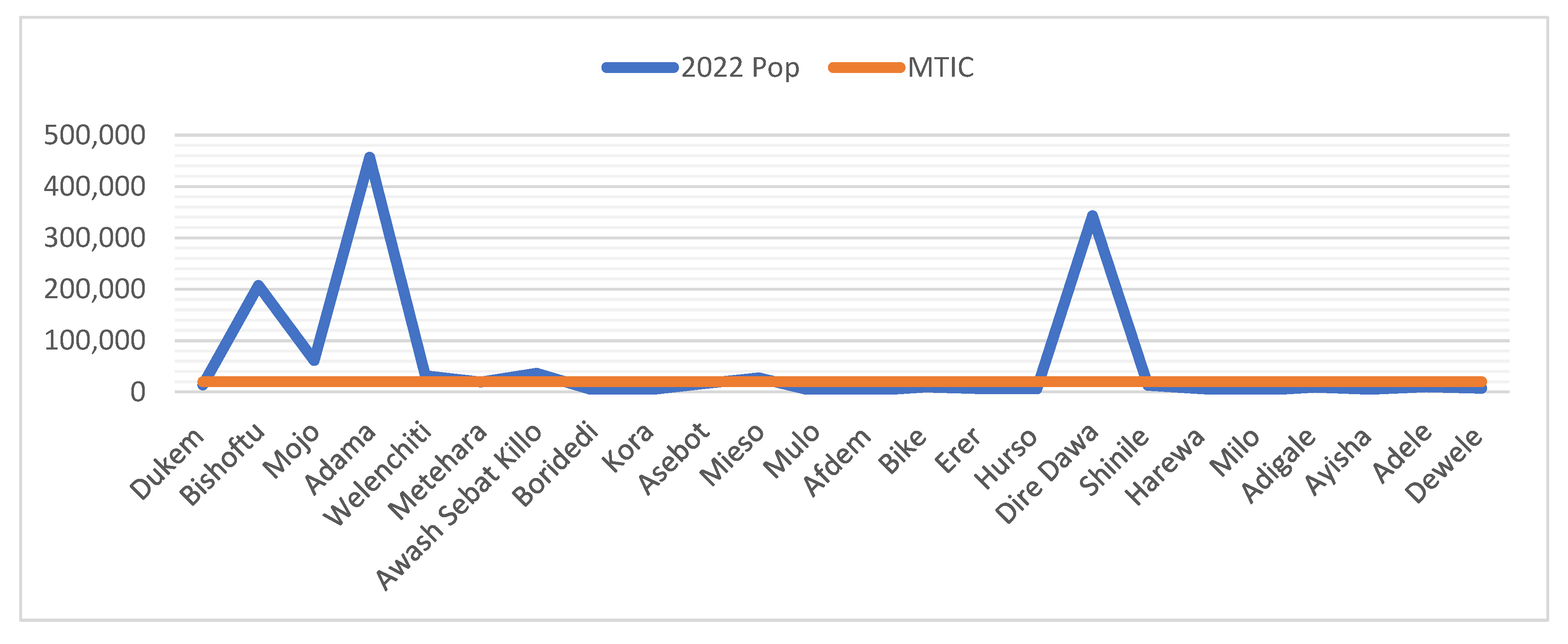
Figure 2.
Population Size for Station Based Urban Centers on the Ethio-Djibouti Railway Corridor.Source: CSS, 2022; Computed by Authors.
Figure 2.
Population Size for Station Based Urban Centers on the Ethio-Djibouti Railway Corridor.Source: CSS, 2022; Computed by Authors.
3.3. Railway Corridor Development
3.3.1. An Overview
The word corridor refers to passageway or ‘route’ or ‘ ‘an area or stretch of land identified by a specific common characteristic or purpose’ [18]. Epistemologically, the term ‘corridor’ derived from Latin word ‘currere’ meaning to run [19]. Whebell (1969), explain corridor as ‘a linear system of urban places together with the linking surface transport media’ [20]. From the physical or spatial planning perspective corridors are bundles of transport and logistics infrastructure that connects two or more urban centers [21].
As one of the major terrestrial infrastructure, railway corridors have significant roles for urbanization, which results in industrialization and rural-urban integration. The railways transports represents an essential aspect of socio-economic urban life and railway transportation systems, comprises of network and nodes or growth poles, have distinct urban and regional functions [19]. The railway transport system has spatial structure of infrastructure corridors and stations. Often, stations serve as nodes for access to transport networks. The provision and improvement of railway transport infrastructure can give rise to growth in productivity through the reinforcement of agglomeration of people and resource benefits [22]. An ideal infrastructure corridor and station design and development with advanced materials will create more sustainable urban and regional environment [19].
3.3.2. Historical Incites on Railway Corridor Development in Ethiopia
In the beginning of the 20th century terrestrial transport was introduced in Ethiopia. Emperor Menelik II is well known in his effort to modernize Ethiopia [23]. Of the different modernization activities, the introduction of the modern communication system was the prominent one. As a communication system, the railway transport with its intrinsic element of the telegram was started construction and installation during the Emperor Menelik II reign period [4]. Unlike other African countries, the concept of railway line construction was conceived by indigenous African leader i.e., the Emperor and followed innovative management strategy using public private partnership (PPP) approach to design, built and administer the railway transport corridor.
The mission to undertake the railway project was given to Ilg on the 11th of February 1893 [4]. Accordingly, Igl with his friend the Frenchman, Leon Chefneux, who had been active in the country since 1882, went to Europe in quest of the necessary capital and to established a company. Then the Imperial Railway Company of Ethiopia or ‘Compagnie Imperiale des Chemins de fer d’Ethioie’ was established in 1894. After the necessary preparation, the railway construction started in 1897, with the French standard. This old trans-regional Ethio-Djibouti Railway was a single metric gauge (950mm), with 781 km length that stretched from the Ethiopian capital Addis Ababa to the port of Djibouti. The construction of railway line was accompanied with the installation of telegram and construction of stations. The first commercial service was started from the port of Djibouti to the border town Dewele, Ethiopia in 1901. Then the railway reached Dire Dawa in 1903. After a number of ups and downs the railway line reached Addis Ababa in 1917. This railway corridor had been serving as the main economic corridor for the landlocked Ethiopia until the 1950s, when it began facing competition from road transport and federation of Eritrea with the Assab and Massawa ports. Following to this period the railway corridor become declining from time to time due to lack of maintenance and management.
Then after the independent of Eritrea (1993), particularly after the border conflict of Ethiopia with Eritrea (1998), the government forced to revitalize the old Ethio-Djibouti railway corridor, which deteriorated and partially destroyed due to old age and civil wars. Since then, the government used the port of Djibouti as the main gateway for landlocked Ethiopia. Specifically in 2007, the government of Ethiopia established technical advisory group under the Ministry of Transport to undertake a framework for the revitalization and development of railway corridor. The study emphasized the importance of modernization and expansion of the existing 950m gauge railway to a standard gauge (1,435 mm) line to provide faster access to the Port of Djibouti from inland Ethiopia.
The New Standard Guage Railway Corridor
As the major infrastructure development plan, the national railway lines revitalization and development project is very crucial to meet the infrastructure demand of the country, boosting the national economy and bringing urban development and land use dynamics. For the realization of this railway infrastructure, the country has designed National Railway Network of Ethiopia (NRNE) project and established the Ethiopian Railway Corporation (ERC) to administer it [17,24,25] .
As Figure 3 indicates, there are two railway corridors i.e., Sebeta to Dewele and Awash Sebat Kilo to Weldia are completed. Of these, Sebeta to Dewele corridor is operational. This new standard gauge railway line is constructed adjacent to the old railway line. The new railway standard gauge brings considerable advantages for long distance freight transport on reducing travel times, from up to 50 hours down to 10 hours.
The newly operational standard gauge (1,435mm gauge line with 25kv electrification) railway line is the first environmentally friendly cross border railway corridor in Africa. It is part of the Road and Belt Initiative constructed with a total amount of 5.1 billion USD as of the 2011 value. The railway corridor has a total length of 743.44km with Sebeta to Adama 115Km double track and the remaining line is single track one [9]. From the total length of the railway line 645.44 (86.81%) is located in Ethiopia.
The new railway line limits the number of stations into 20. Among these majority 17 (85%) of the stations existed in the Ethiopian Jurisdiction; from these Bishoftu, Mojo, Adama, Methara, Awash Sebat Killo, Meiso and Dire Dawa have stations located in the vicinity of corresponding intermediate cities.
Figure 3.
The New Standard Guage Railway Corridors; Source:[26].
Figure 3.
The New Standard Guage Railway Corridors; Source:[26].

Table 1.
The New Standard Gauge Railway Stations on the Ethio-Djibouti Ralway Corridor.
| Station section | Distance in Km | Distance Between Major Fright Stations | |||
|---|---|---|---|---|---|
| From | To | From | To | KM | |
| Sebeta | Lebu | 13.322 | Sebeta | Indode | 31.631 |
| Lebu | Indode | 18.309 | |||
| Indode | Bishoftu | 37.61 | Indode | Mojo | 58.263 |
| Bishoftu | Mdjo | 20.653 | |||
| Modjo | Adama | 23.361 | Mojo | Adama | 23.361 |
| Adama | Feto | 41.171 | Adama | Awash | 157.15 |
| Feto | Methara | 63.122 | |||
| Methara | Awash Sebat Killo | 29.496 | |||
| Awash Sebat Killo | Sirba Kunkur | 43.4 | Awash | Dire Dawa | 191.8 |
| Sirba Kunkur | Mieso | 48.28 | |||
| Mieso | Bike | 35.56 | |||
| Bike | Dire Dawa | 64.56 | |||
| Dire Dawa | Arawa | 53.068 | |||
| Arawa | Adigala | 61.778 | |||
| Adigala | Aysha | 50.95 | |||
| Aysha | Dawele | 40.8 | |||
| Dawele | Alishabeh | 20 | |||
| Alishabeh | Holhol | 46 | |||
| Holhol | Negad | 32 | |||
| Total | 743.44 | ||||
Source: [27], 2022; Computed by Authors.
3.4. The Impact of the Railway Corridor in Ethiopia
3.4.1. Urban Formation and Urbanization
Corridor oriented urbanization is directly related to linear or ribbon pattern urban form concept. As a planning concept, linear or ribbon urban development was introduced in the late 19th century by the Spanish urban planner known as Soria y Mata (1844-1920) who developed an idea of the Ciudad Lineal, a linear garden city [28,29]. Following to him planners like Hilberseimer (1955) gives special attention for ‘a linear system of urban growth with strong connecting links’, through producing maps that depicts this fact; and the architectural historian George R. Collins (1960s), theorized the notion of linear oriented urbanization [28]. “...linear growth is the natural pattern of growth of urban regions. Cities develop along a linear passage called corridor which is usually its artery of transport for people, for goods, and for services: roads, rails, pipes, and wires” [30]
The linear urbanization is mainly a modernist concept and can be regarded as urban/spatial expression of modernist (Fordist) production, inspired by repetition, mass production, and the development of the train, highway and the assembly line [31].
The technical term ‘corridor’ was used in urban and regional planning in the late 1950s [28]. Then the corridor development concept become an explicit part of urban and regional spatial planning [32]. Corridor based linear or ribbon urbanization, can be observed as an evolutionary and long-term concept for urban or regional development, taking into consideration technological and locational assets and changes [31]. The corridor urban center, as part of a historical urban pattern- be regarded as spatial expression of postmodern flexible production and decline of spatial fixation [31].
Usually, corridor-oriented urbanization flourished around stations or terminals. At the early stage of urban formation, infrastructure corridor based urban center characterized as monocentric, taking station as the sole growth pole. Through time station based monocentric urban centers developed multiple hubs like administration hub, commercial hub, industrial hub. This makes the urban center to have wider width that transform to multi nodes or growth poles.
In the beginning of 20th century modern type of railway transport was introduced in Ethiopia. The advent of these modern terrestrial railway infrastructure caused for the flourishing of the eastern economic corridor. This ester railway corridor was one of the major causes for the flourishing of urban centers that evolved on the major morphological tissues of railway line and stations.
This single gauge (950mm) railway had more than 34 stations and 20 station based urban centers. For that matter the number of railway stations varies from time to time depending on the advancement in the railway locomotives: steam engines, diesel engines and electric-power engines.
Initially, these stations courtyards had a few buildings that served for providing limited railway service-related functions such as ticket selling, passengers waiting, administration, residential for staff, and warehouse.
Those stations which had a residential house in the courtyard attracted different kinds of urban service providers and traders to live a sedentary life in the vicinity of stations. Then station areas gradually evolved into the urban village and urban centers. All station-based urban centers were evolved organically, except Dire Dawa.
In this sub section, the article examines the population dynamics (population size and growth rate in a time horizon) and Morphological traits (station location and station yard function) of station based urban centers with special emphasis on station based intermediate cities.
3.4.1.1. Population Dynamics
- A.
- Population Size
During the early period of modern Ethiopia, railway corridor specifically stations played a significant role in the formation of urban centers and introducing new dimensions of urbanization. The old railway corridor causes for the flourishing of more than 20 urban centers. All these railway station-based urban centers were flourished before the Italian aggression (1935-1940). Although these urban center has greater than 100 years old, only 8 station-based urban centers have greater than 20,000 inhabitants.
To compute population dynamics of station based urban centers, the article used the 1984, 1994 and 2007 census results and the 2015 and 2022 Central Statistical Service (CSS) projection.
As figure 4 indicates, during the 1984 census, with the exception of Adama and Dire Dawa all station based intermediate cities had less than 50,000 inhabitants. In the 2022 CSS projection Adama shown significant population growth, followed by Dire Dawa and Bishoftu.
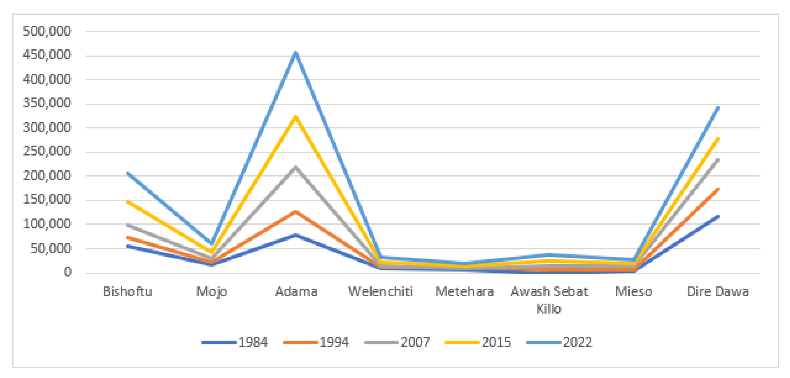
Figure 4.
Population Size of Ethio-Djibouti Railway Corridor based Intermediate Cities. Source: Computed by Authors from CSA/CSS 1984, 1994, 2007, 2015 and 2022 reports.
Figure 4.
Population Size of Ethio-Djibouti Railway Corridor based Intermediate Cities. Source: Computed by Authors from CSA/CSS 1984, 1994, 2007, 2015 and 2022 reports.
- B. Population Growth
With regards to the population growth rate, all intermediate urban centers had less than zero between the first two consecutive census periods of 1984 and 1994. However, between the last (2007) and the 1994 census period, with the exception of Dire Dawa and Metehara all intermediate urban centers show improvement in their growth rate. It is known that in the year 2007 renovation plan for the old railway line was started and in the year 2011 the new standard gauge railway construction was started. Taking the revival of the railway corridor as one of the major factor majorities (6 or 75%) of the intermediate urban centers exhibited similar growth rate. The overall growth rate (1984-2022) of railway corridor based intermediate cities indicates that only Meiso (6.54), Adama (4.91) and Awash Sebat Kilo (4.19) demonstrates above the national urban average growth rate i.e., 3.7 [33]. (See Figure 5)
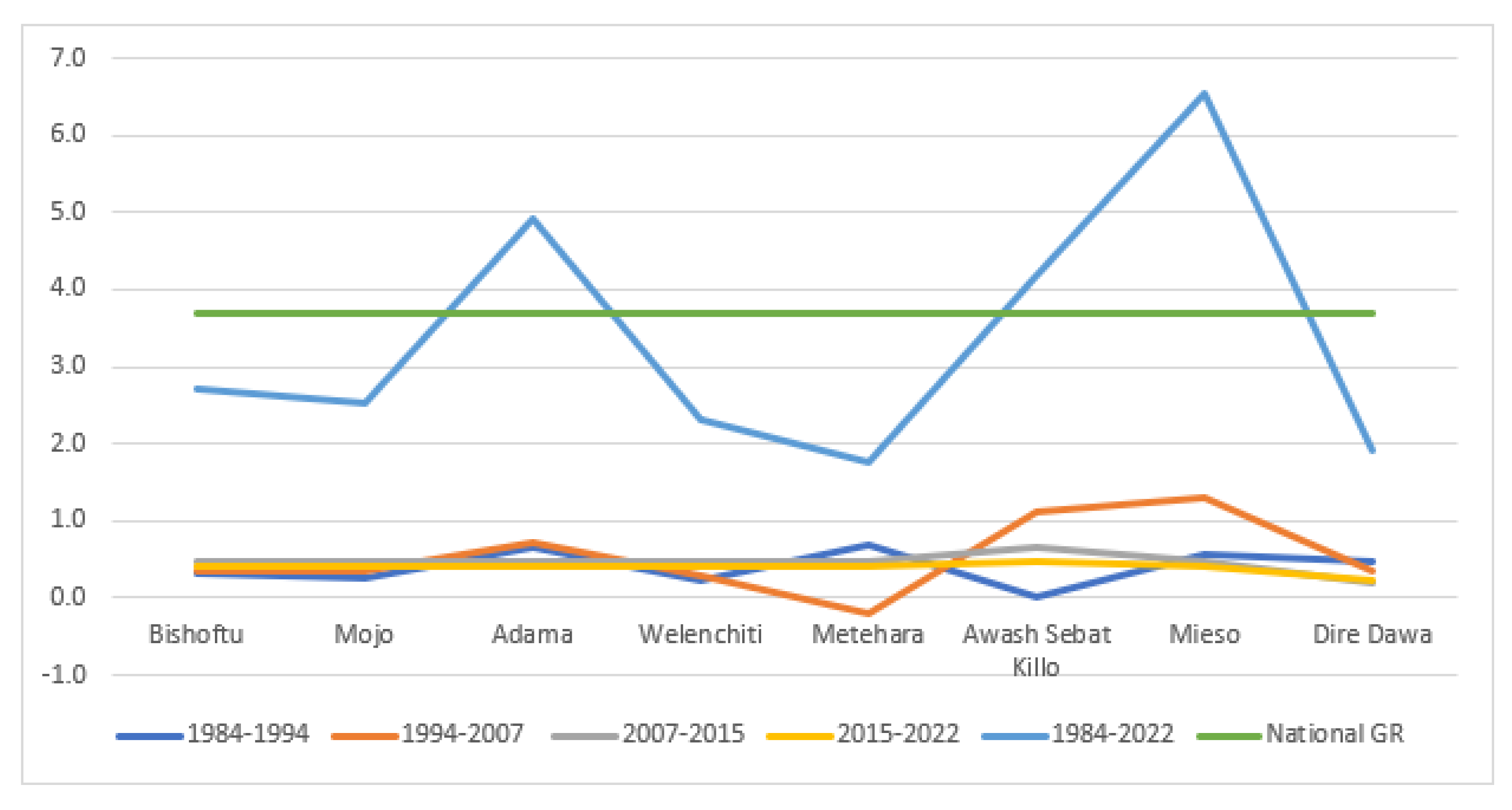
Figure 5.
Population Growth Rate for Station Based Intermediate Cities. Source: Computed by Authors from CSA/CSS 1984, 1994, 2007, 2015 and 2022 reports.
Figure 5.
Population Growth Rate for Station Based Intermediate Cities. Source: Computed by Authors from CSA/CSS 1984, 1994, 2007, 2015 and 2022 reports.
3.4.1.2. Morphological traits of Station in the Intermediate Cities
Railway station is an area which regularly provides railway facilities or stop to load or unload passengers or freights or both. It is generally consists of at least one track side platform and a station building, which provides auxiliary services like ticket sales, waiting rooms, baggage/freight services.
Station might be existed at the ground level, underground and elevated level. All the Ethio-Djibouti railway station are located at the ground level. There are different determinant factors for the selection of convenient sites for railway location the following are the prominent ones:
- i.
- Affordability: the distance between station and localities should be affordable for users;
- ii.
- Connectivity: the station should be linked with the nearby areas with proper road;
- iii.
- Safety: the existence of fairly level ground
- iv.
- Availability: there should be sufficient land for future expansion and development
Taking these into account in the following pages the article analyzed station location, types of station and station yards, which has a direct impact on station based urban centers morphology.
- C. Station Location
In this part station location is analyzed from the railway engineering, nature of locomotives, and city perspective point of views.
- From Railway Engineering Perspective
From the engineering perspective stations location can be categorized in to three taking the position of stations in line with the railway line infrastructure. There are:
- i.
- Way-side station: is located on running lines. This allows faster train to overtake a slower train. For this loop line and siding are provided.
- ii.
- Junction station: railway lines from three or more directions meet the junction has minimum of one main line and other branch line.
- iii.
- Terminal station: refers to the dead end of incoming track or the station at which railway line ends or terminate.
From these station types all the old railway stions were way-side station type. Similarly, all the stations constructed on the new standard gauge railway line way-side station types are exhibited. Therefore, all the intermediate cities that are located on the trans-regional Ethio-Djibouti have way-side station type.
- 2.
- From the Nature of Locomotives
The number of railway stations varies from time to time depending on the advancement in the railway locomotives: steam engines, diesel engines and electric-power engines. At the initial stages of the railway transport service all the locomotives were steam engines; because of this majority of the stations were constructed near to water bodies (river banks or lacks), which had cooler purpose to the steam engines. With the advent of diesel engine locomotive, the number of stations decreased significantly. The old Ethio-Djibouti railway line caused the development more than 34 stations and greater than 20 station-based urban centers. The survived rail stations gradually evolved to urban centers. Based on this the old railway stations can be grouped in two: stations near to water body and stations without water body. From the eight intermediate cities Bishoftu, Mojo, Metehara, Awash Sebat, Mieso and Dire Dawa railway stations were constructed near to water body.
- 3.
- From the City Perspective
The development of new standard gauge railway corridor reduced the number of stations 34 to 20. Among these majority of 17 (89.47%) stations exist in the Ethiopian Jurisdiction. As stated above the old railway stations served as a nucleus for the formation of urban centers. However, the new standard gauge railway stations used a peripheral approach and all of the stations are located far from the centers ranging from 1 km to 11 km. (See Table 2) The functional stations of Bishoftu, Adama, Metehara, Mieso and Dire Dawa stations are located in the vicinity of intermediate cities. For example, in Dire Dawa, the ground distance between the new and old railway stations is greater than 11 km.
Table 2.
Distance between old and new railway stations.
| Name of Urban Center | From/To | Distance in KM |
|---|---|---|
| Bishoftu | Bishoftu old railway station to new station | 3.74 |
| Mojo | Mojo old railway station to new station | 2.3 |
| Adama/Nazret | Adama old railway station to new station | 5.78 |
| Welenchiti | Old railway station to new station | 1.03 |
| Metehara | Metehara old railway station to new station | 1.71 |
| Awash Sebat Kilo | Awash Sebat Kilo old railway station to new station | 2.86 |
| Mieso | Mieso old railway station to new station | 5.13 |
| Dire Dawa | Dire Dawa old railway station to new station | 11.77 |
Source: Authors, 2023.
- D. Station Yards
Station yard is a place on the track where train stops for clearing passengers and goods traffic. In general station yards can be categorized as: passenger bogie, goods/freight, locomotive and marshalling yards.
On the old trans-regional Ethio-Djibouti corridor station based intermediate cities the station of Bishoftu, Mojo, Adama, Metehara, Awash Sebat Killo, Mieso, Dire Dawa were served for both passenger and freight services. On the other hand, Welenchiti station was served only for passenger. The station of Awash Sebat Killo and Dire Dawa were also served as locomotive yards in which all the facilities of cooling, watering, repairing, oiling, cleaning etc. services were provided.
There were also stations that are located between intermediate cities. These stations known as dry station or ‘derek tabiya’ in local language, which were served as mobile maintenance services center. For instance, Dalota, Lemlem, Dankaka, Tedie Mariam, Soleqie, Feto, Borchota, Haro Arba, Sabu Ber, Legebenti, Eilala Sela, Awash Eisht were dry stations located between Bishoftu and Dire Dawa.
Currently there is a functional standard gauge railway line, on this corridor there are stations constructed to provide passenger or freight or both services. From the eight intermediate cities Mojo, Adama, Metehara, Mieso, and Dire Dawa, providing both passenger and freight services. On the other hand, only Bishoftu station has been providing passenger services.
3.4.2. Industrialization
Industrialization is the process of sectoral transformation in which industry is dominated [34]. The transport infrastructure corridor particularly the railway corridor has been an indispensable impact for industrial development and industrialization process. Industrialization is the key to economic development [35]. Modern industrial sectors improve productivity, fosters innovation, and facilitates technology diffusion and other positive spillover effects [35]. Nations used different policy options for the realization of industrialization in their country. The prominent policy options are: import substitution, export-oriented industrialization, special economic zone and agro-industrial parks [35].
Scholars argued that, railway corridors and industrial parks has a direct nexus for the emergence of ‘intermediate city’ [36]. There are different types of intermediate cities and these can be broadly categorized in to: regional, clustered and corridor intermediate cities [36].
Most of the Ethio-Djibouti trans regional railway corridor based urban centers lays in clustered intermediate cities. The selected eight case study urban centers has been serving as growth poles on the Ethio-Djibouti railway corridor and in some cities such as Bishoftu, Mojo, Adama and Dire Dawa industrial cluster has been developing in the form of IP at the peripheral parts of respected cities.
In Ethiopia the origin of modern industrialization dated back to the early twenty-first century. The advent of the old Ethio-Djibouti railway transport plays an indispensable role for agglomeration of industries and trade centers such as Akaki, Dukem, Bishoftu (Debre Zeit), Adama (Nazret), Mojo, Metehara, Awash and Dire Dawa.
Recently the Ethiopia Government has been constructing industrial parks in different parts of the country. The government followed the SEZ policy approach with the intention of maximizing social and economic development through job creation, export generation, import substitution and know-how and technology transfer from investors. The rate and scale of industrial parks development by the Federal Government, regional states, and private developers has had an affirmative effect on the urbanization processes [37]. These industrial parks have, in turn, intensified the growth and development of already-existing urban centers, or have created cluster cities [37].
Currently, there are a total of 25 industrial parks (IP) that are operational in Ethiopia, of which 17 are government-owned (14 by the Federal government and 3 by the regional states) and 7 are privately-owned. The Chines owned Eastern IP covering 400 hectares was inaugurated in 2010 as the first privately-developed IP. The total area allotted for IP is 20,830.47ha, form this IP along the Ethio-Djibouti railway Corridor covers 9,402ha or 45%.
Table 3.
Industrial Parks Located on the New Standard Gauge Railway Corridor.
| No. | Name of IP | Acquired Land (in ha) | Urban center | Specialization | Status |
|---|---|---|---|---|---|
| 1 | Bole Lemi IP – I | 172 | Addis Ababa | Textile & Garment | Operational |
| 2 | Bole Lemi IP – II | 181 | Addis Ababa | Textile & Garment | Operational |
| 3 | Adama | 2000 | Adama | Assembling, food processing & Garment | Operational |
| 4 | Dire Dawa IP | 4186 | Dire Dawa | Assembling, food processing & Garment | Operational |
| 5 | Kilinto IP | 279 | Addis Ababa | Pharmaceutical, Medical equipment | Operational |
| 6 | Aysha IP | 1000 | Somali | Live stock | Planning stage |
| 7 | Bishoftu IP | 189 | Oromia | Planning stage | |
| 8 | ICT IP | 200 | AA | ICT | Operational |
| 9 | Addis Industry Village | 9 | AA | Garment | Operational |
| 10 | Mojo Leather Industry | 290 | Oromia | Leather | Planning stage |
| Sub-Total | 8,334 | ||||
| 1 | Eastern Industrial Zone | 500 | Oromia | Various | Operational |
| 2 | Huajian Light Industry City | 138 | AA | Shoes & Garment | Operational |
| 3 | Mojo George Shoe Industrial Park | 50 | Oromia | Leather | Operational |
| 4 | CCECC | 380 | Dire Dawa | Various | Under Construction |
| Sub-Total | 1,068 |
Source: Authors, 2023.
Similar to the railway line and stations, all the industrial parks have been developed on agricultural land. Which have an adverse impact on agricultural production and socio-economic impact on the agricultural communities living in the fringe areas of intermediate cities.
3.4.3. Regional Integration
Regional integration is a means to “achieve sustained, equitable and inclusive economic growth in least developed countries […] and overcoming their marginalization through their effective integration into the global economy” [38]. It also emphasizes on facilitating development in least-developed countries through improved productive capacity, infrastructure, and trade.
Regional integration is crucial for sustainable and inclusive development [39]. It cannot happen without adequate infrastructure. Due to this regional integration offers opportunities for leveraging urbanization for industrial demand, including across borders. Railway transportation corridor are critical for linking regional cities and zones of industrial production.
For a land-locked country, railway infrastructure is an important component of regional integration. It offers opportunities for further leveraging momentum of cross-border economic linkage and urbanization for industrial demand. Special economic zones, can have a bigger impact if well managed and connected to urban centers.
- (A)
- Rural-Urban Continuum
In the rural-urban dichotomy, there are areas neither rural nor urban features that are located in the immediate vicinity of cities. Different scholars examine these urban fringe areas as: peri-urban, suburban, rurban, rural-urban continuum, composite settlements, gragara, and desakota settlements, depending on the region’s size, scale, and settings [40]. In the fast urbanized world, fringe development is inevitable; however, there is seldom recognition and definition for such kinds of area [40].
In the trans-regional Ethio-Djibouti railway corridor station based intermediate cities, there is urban expansion or fringe development phenomena. This fringe development phenomena have a rural-urban continuum (RUC) feature. RUC refers to the merger of rural and urban areas, thereby eradicating the assumption of a clear-cut distinction between the two dichotomy areas.
Based on the morphological settlements pattern urban fringes can be broadly categorized as: Polycentric urban centers formed by multiple monocentric cities; Ribbon Development; and Desakota Settlements [40].
In Ethiopia, ribbon development urban morphology phenomena existed on the north-west parts of Bishoftu, and Dire Dawa and Southern parts of Mojo, and Adama intermediate cities. Previous agricultural land of the fringes Bishoftu, Mojo, Adama, and Dire Dawa intermediate cities gradually converted to urban mainly due to industrial parks development.
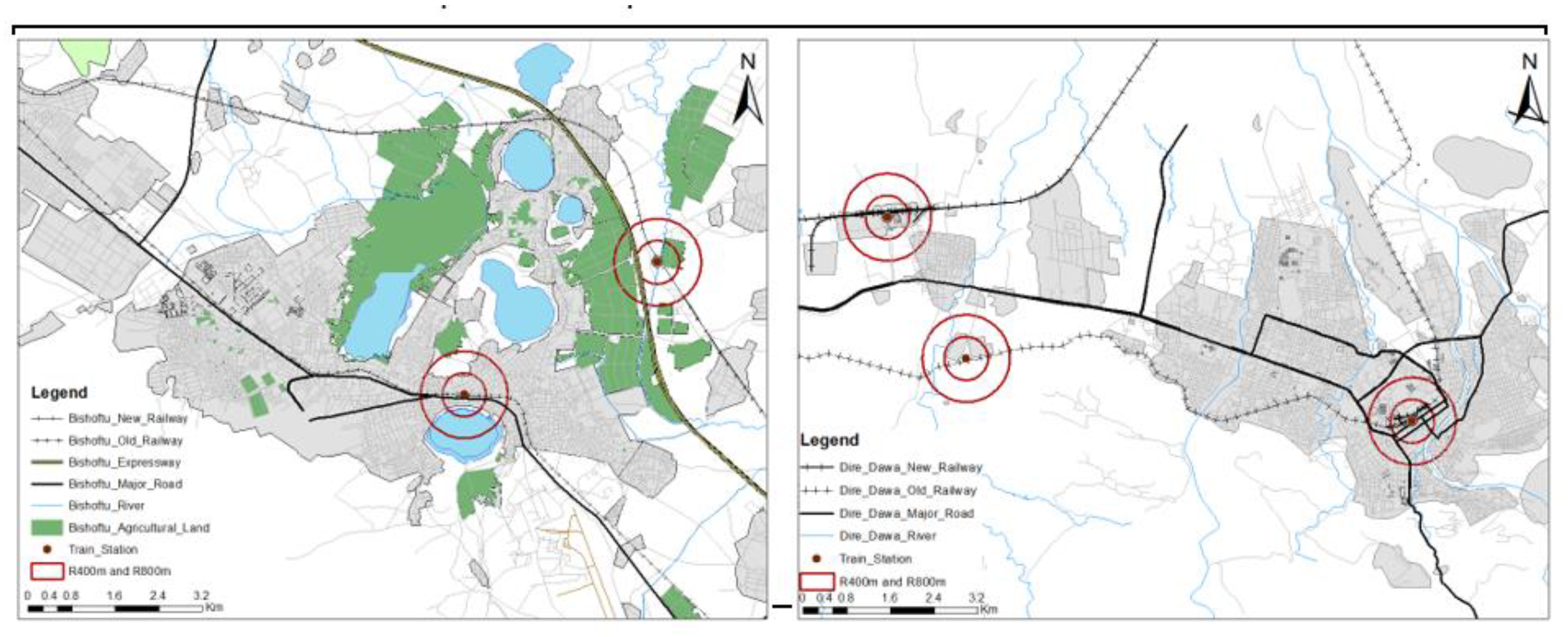
Figure 6.
Bishoftu and Dire Dawa Railway Stations.
In a few intermediate cities polycentric urban centers formed by multiple monocentric cities. For instance, in the northern part of Bishoftu there is monocentric city namely Dukem. This makes RUC morphological settlement pattern in the area. This RUC phenomena stretches to Addis Ababa. For that matter both the old and new railway stations as well as industrial parks were constructed on the agricultural land. An interview with the ERC affirmed that each station of the new standard gauge railway has approximately 300 hectares of land, principally farmland.
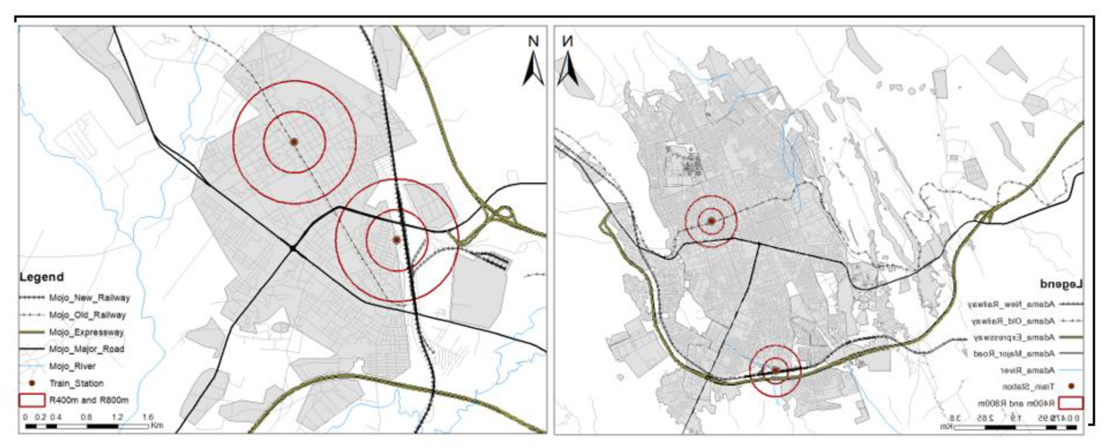
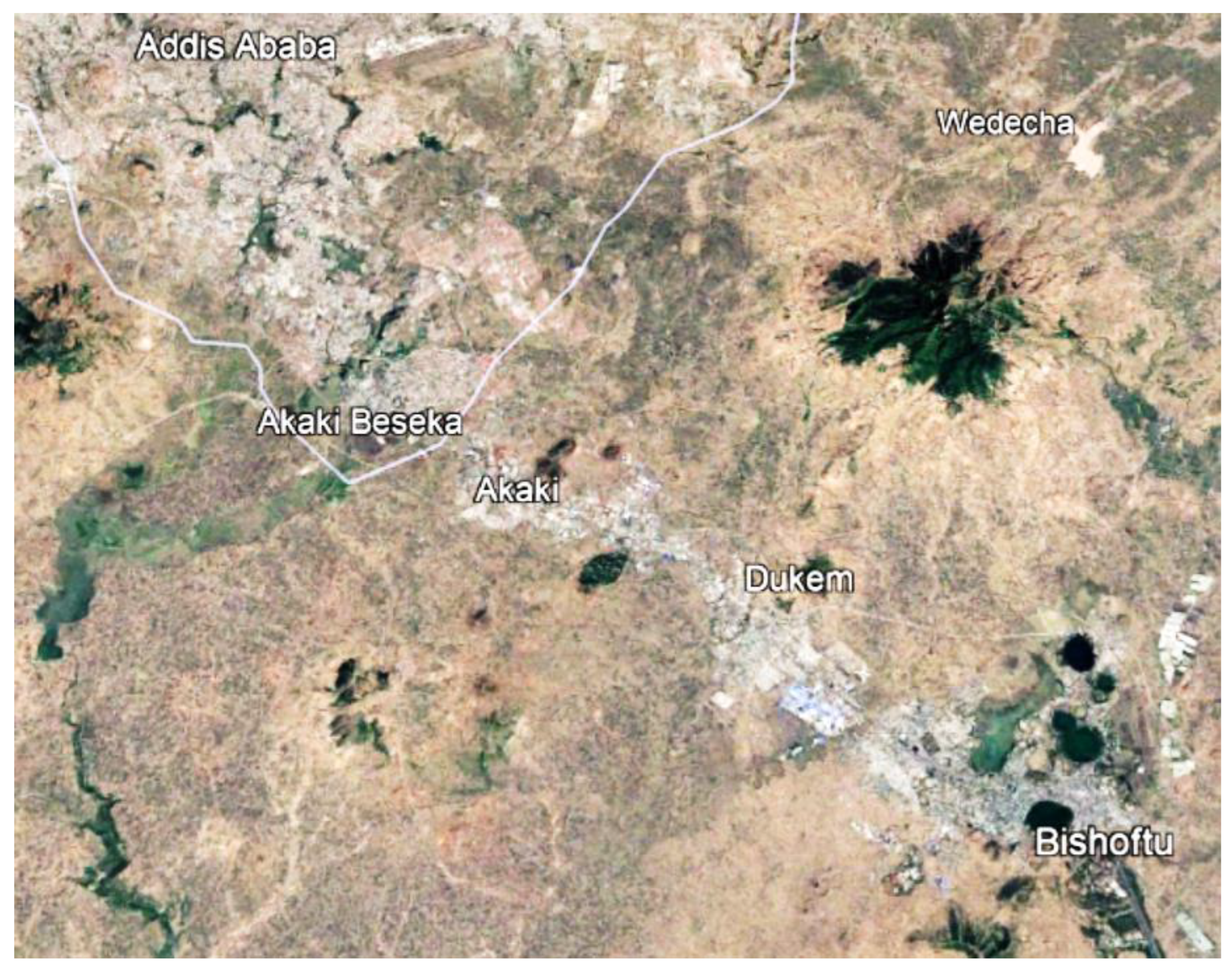
Figure 7.
Mojo and Adama Railway Stations.
Figure 8.
Rural-Urban continuum on the south eastern direction of Addis Ababa.
The other example exhibited in Dire Dawa, as the figure depict there was a monocentric station based urban center i.e., Melka Jebdu located in the north-western direction of Dire Dawa. This nearby station town become part of Dire Dawa city administration. This makes the intermediate city to have more than one development hubs and become polycentric city.

Figure 9.
a & b: Google Image of 1985 and 2021 of Melka Jebdu and Dire Dawa Urban Growth.
- (B) Economic/Trade Integration
Regional integration is linked to competitiveness and innovation through knowledge sharing and network connections. The existing functional standard gauge railway corridor has a trans regional nature that connect land locked Ethiopia to the international trade through the port of Djibouti. This corridor has the highest share (90%) of the international trade.
As Table 8 indicates the performance of Ethio-Djibouti railway company decreased from time to time. Specifically, after 2011 with the government policy direction of modernizing the railway transport system, its performance become ceased.
Table 4.
The Ethio-Djibouti Old Railway Performance.
| Revenue and Transport Service | Year | ||||||||
|---|---|---|---|---|---|---|---|---|---|
| 2000 | 2002 | 2004 | 2006 | 2008 | 2010 | 2012 | 2014 | ||
| Revenue ('000) | Passenger | 13,010 | 18,400 | 5,218 | 6,000 | 2,450 | 2,300 | NA | 5,500 |
| Frights | 50,250 | 37,800 | 37,042 | 27,400 | 7,050 | 5,700 | NA | NA | |
| Total | 63,260 | 56,200 | 42,260 | 33,400 | 9,500 | 8,000 | |||
| Transportation Service | Passengers Travel in Km (Million) | 145 | 254 | 40 | 24 | 26 | 5 | 15 | |
| Freight carried ('000 Tons) | 285.3 | 95 | 204.3 | 123 | 76 | 2 | |||
Source: CSA 2000-2014.
The new standard gauge trans-regional Ethio-Djibouti railway corridor served for more than 500,000 metric tons cargo and generating ETB 2.5 billion revenue in the past five years. According to the Ethiopia-Djibouti Railway Company, the railway corridor has 11.2% to 15% contribution to the East African country’s overall export and import trade.
Figure 10 depicts that the new standard gauge railway corridor starts operation in 205/16. However, the corridor officially started commercial service in January 2018. The Corridor is jointly owned by the two sovereign states of Ethiopia and Djibouti. The railway company assign a Chinese Consortium to manage the corridor through a management contract.
As the ERC official indicates, initially the new standard gauge railway corridor was designed to operate with an average speed of 80km/hr with a freight tariff of 0.046 per ton/km and 0.023 per ton/km for import and export respectively. Compared to the road corridor, trucks usually cover 903Km length road that stretches from Addis Ababa to the port of Djibouti with the average speed of 60km/hr with a tariff of 0.047USD/ton/km. Due to transportation speed/time, safety, and price the modal share of the railway transport shows 80% to 85% coverage than the truck transport system. (See Figure 11)
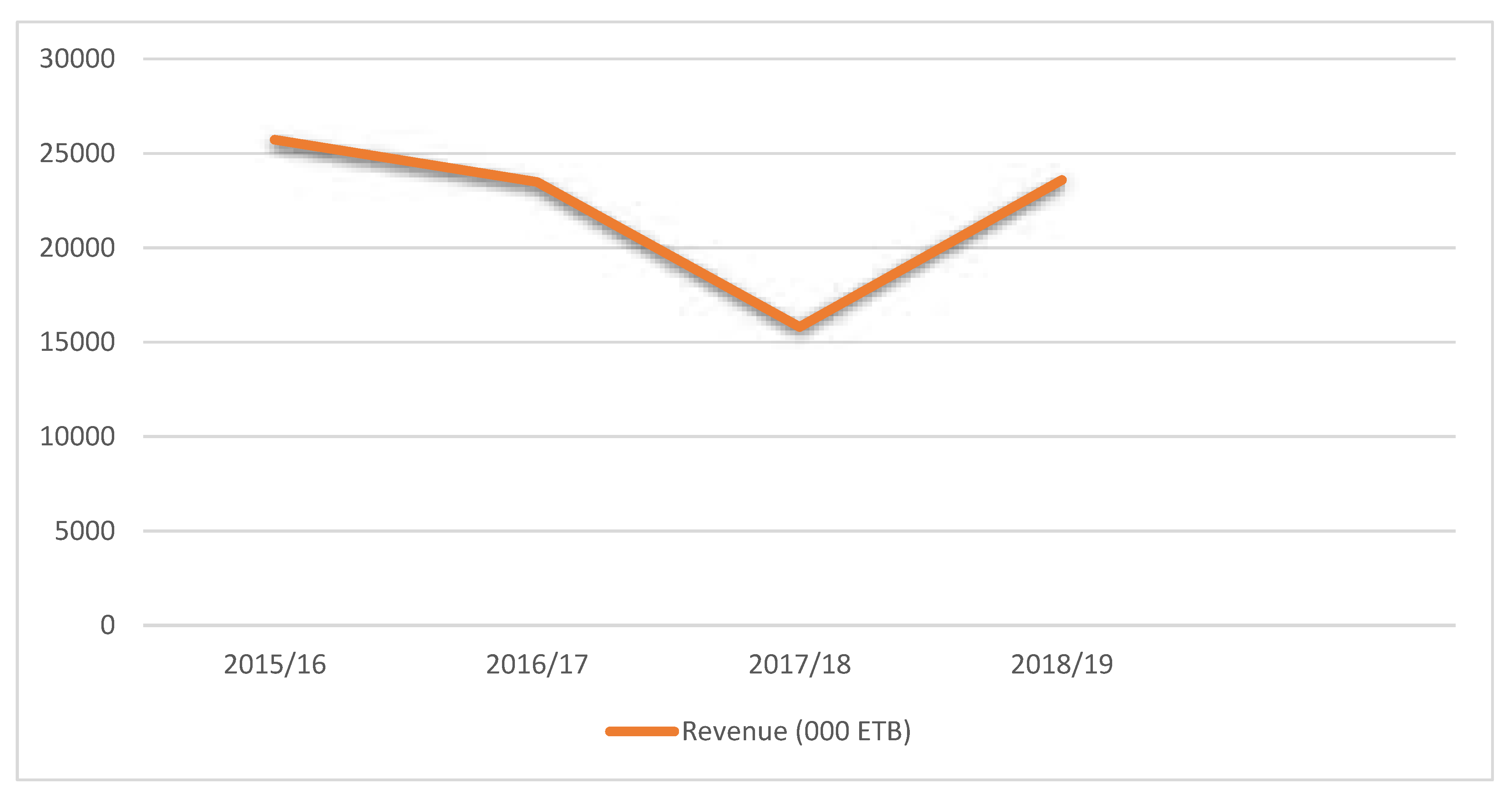
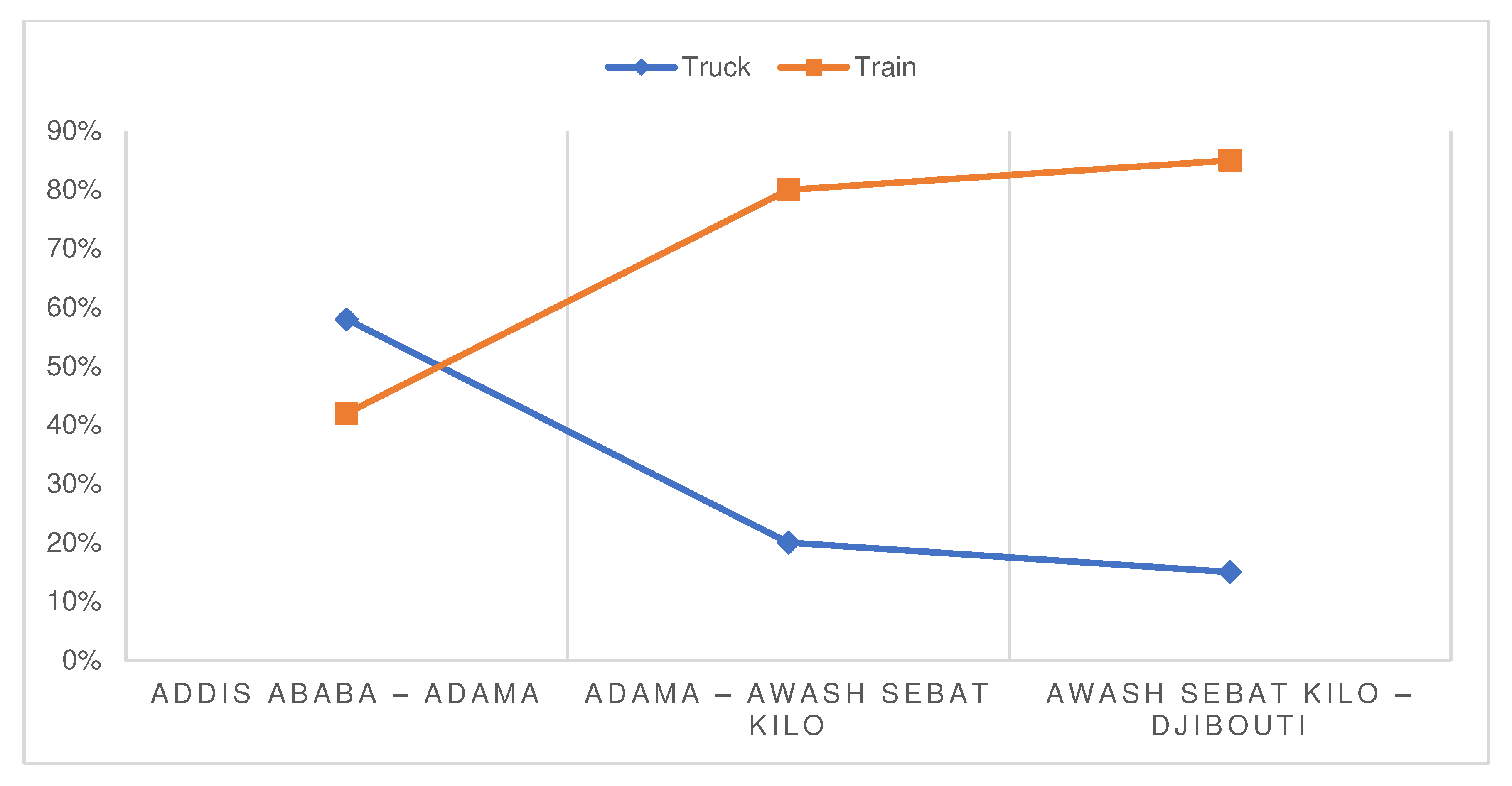
Figure 10.
Revenue performance of the New Standard Gauge Ethio-Djibouti Railway Corridor.
Figure 11.
Modal Share of Truck and Train On the Eastern Economic Corridor.
- (C) Regional Integration
Taking the current state structure, both the old and new standard gauge railway lines pass through four regional states and two city administrations. Namely: Oromia, Amhara, Afar and Somali regional States, and Addis Ababa and Dire Dawa City Administrations. (See Figure 11)
From the intermediate cities’ perspective, majority (6 or 75%) of the cities are located in Oromia regional state and three of them (Bishoftu, Mojo and Adama) are located within 100km radius from the metropolitan city of Addis Ababa. The remaining two are existed one i.e., Awash Sebat Kilo in Afar regional state and one in Dire Dawa city administration.
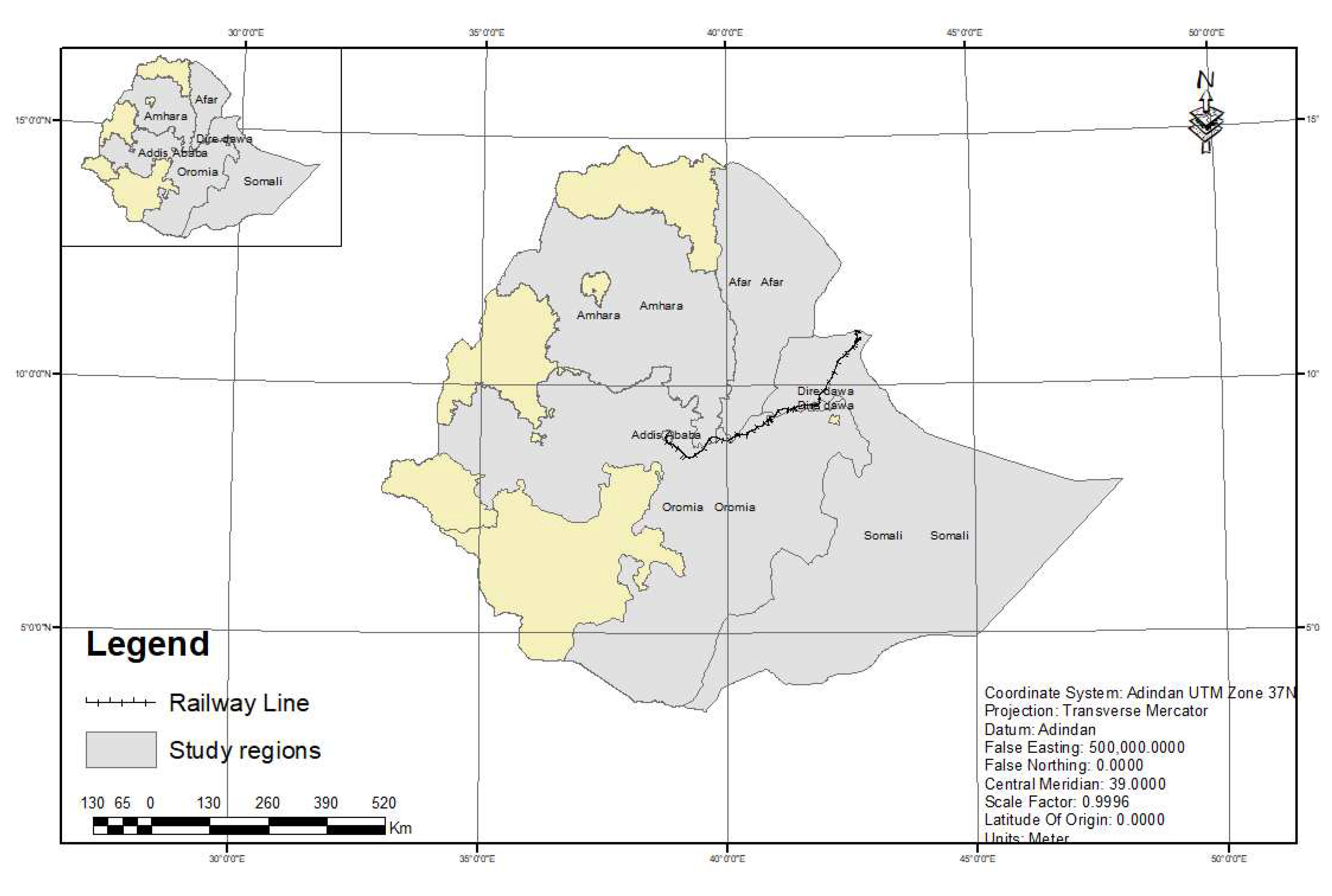
Figure 12.
The Eastern Trans-Regional Railway Corridor.
4. Measures to Optimize the Positives Impacts of Railway Corridor
In the academia world, there are different regional development theoretical paradigms; of which functional and territorial integration development approaches are the two dominant ones [41]. The former used top-down development approach, which aims at efficiency and modernization using principles, means and practice of national economic planning, free trade, entrepreneurship and innovations as the driving forces for industrialization, comparative advantage principle and central government intervention [41]. Often the functionalist employed growth center and rural service center strategies for regional development planning [41]. On the other hand, territorialism followed ‘bottom up’ development approach, in which a change of development should based on economic criteria, competitive behavior, external motivation and large-scale redistributive mechanisms to a new model of development incorporating broader societal goals, collaborative behaviour and endogenous motivation [41].
As Ethiopia followed Federal state structure the power to develop, administer and regulate railway lines linking two or more regional states is given to the Federal government [42]. As the railway infrastructure is one of the enter-regional development, ERC designed, constructed, and administer the new electrified Ethio-Djibouti standard gauge railway line. However, this railway corridor has the following drawback:
- (a)
- Inadequate normative farmwork which makes institutional linkage to create sound interaction among federal, regional and city administrations; because of this limitation, almost all of the station towns do not have functional and territorial integration with the railway station.
- (b)
- Both the old and new stations had/have limited functions most of them were/are providing limited commuter related services like sealing tickets.
- (c)
- The old railway stations were constructed in the vicinity of water body without taking into account its potential to become future urban centers.
To overcome these problems and optimize the yield railway corridor benefits for urbanization, industrialization and regional integration the government should follow:
- (a)
- Hybrid regional development policy that obtains both functional and territorial integration on the corridor;
- (b)
- Sould station development approach preferably Transit Oriented Development (TOD), this will help planners to incorporate the station and its courtyards into urban strategies; they reinforce its role as a mobility hub and public place for people to meet and work.
- (c)
- The government should develop regulatory framework that promotes cooperation and collaboration in economic, social and environmental growth dynamics between ERC and station based urban center authorities.
- (d)
- Work with the private sector using PPP approach. This will help to preserve old railway station buildings as a historical building and serve as a gallery for the railway historical events as well as an economically vibrant retail area; and station courtyard with 800m radius will also serve as a mixed-use real estate area.
Conclusions
In Ethiopia railway corridor development was started in the beginning of the 20th century. The advent of railway corridor development caused for the flourishing of station based monocentric linear urban centers. Although, this eastern railway infrastructure-based railway corridor has more than 34 railway stations and greater than 20 station based linear urban centers, only eight reached the statues of intermediate cities with having 20,000 inhabitants. With regards to the overall population growth rate (1984-2022), only Meiso (6.54), Adama (4.91) and Awash Sebat Kilo (4.19) intermediate cities demonstrates above the national urban average growth rate i.e., 3.7.
Morphologically, all stations are located at the ground level, using ‘way-side’ station approach. Initially, all the locomotives were steam engines; thus, with the exception of Welenchiti all stations were constructed near to water bodies. The old railway stations served as a nucleus for the formation of urban centers. However, the new standard gauge railway stations used a peripheral approach, which located far from the centers ranging from 1 km to 11 km.
The advent of the old railway corridor also plays an indispensable role for clustering of industries and trade centers, and the new railway corridor also attracts SEZ in the form of IPs. The railway corridor demonstrated RUC, specifically the ribbon development and polycentric urban centers formed by multiple monocentric cities.
From the regional integration vantage point, the railway corridor passes through Oromia, Amhara, Afar and Somali regional States, and Addis Ababa and Dire Dawa City Administrations. Of this majority (6 or 75%) of the intermediate cities are located in Oromia regional state and three of them (Bishoftu, Mojo and Adama) are located within 100km radius from the metropolitan city of Addis Ababa.
The government followed functional integration, which used top-down railway corridor development approach. This makes lacuna on normative farmwork and institutional linkages to create sound integration among federal, regional and city administrations. The stations provide limited functions and the old railway stations were constructed without considering future potential of becoming urban center. To overcome these problems and maximize the benefits of corridor for urbanization, the government should follow hybrid regional development policy; sound station development approach mainly TOD; promulgate regulatory framework that regulate cooperation and collaboration among main stakeholders; and work with the private sector through PPP to make the station yards economically vibrant retail area.
References
- A. Woodlief, "The path-dependent city," Urban affairs review, vol. 3, no. 33, pp. 405-437, 1998. [CrossRef]
- S. J. &. F. T. (. Salm, African urban spaces in historical perspective, University Rochester Press, 2005.
- Z. Beharu, A History of Modern Ethiopia: 1855 - 1991, Addis Ababa: Addis Ababa University Press, 2002.
- R. Pankurust, "Menelik and the Utilization of foreign skills in Ethiopia," Journal of Ethiopian Studies Vol. V, No. 1 , January 1967.
- M. S. Bharti, "The sustainable development and economic impact of China’s belt and road initiative in Ethiopia," East Asia, no. 40(2), pp. 175-194, 2023. [CrossRef]
- M. Kozicki, "The history of railway in Ethiopia and its role in the economic and social development of this country," Studies in African Languages and Cultures, no. 49, pp. 143-170, 2015. [CrossRef]
- Y. Chen, Laying the tracks: The political economy of railway development in Ethiopia's railway sector and implications for technology transfer, 2021.
- UN, "United Nation Department of Economic and Social Affers Population Devesion," 19 June 2023. [Online]. Available: https://population.un.org/wpp/.
- GIH, "Global Infrastructure Hub," Connectivity Across Borders: Global Practice for Cross-Border Infrastructure Project: Case Study Addis Ababa-Djibouti Railway, 30 November 2020. [Online]. Available: https://www.gihub.org/connectivity-across-borders/case-studies/addis-ababa-djibouti-railway/. [Accessed 06 June 2023].
- D. E. Gray, Doing Research in the Real World, London : SAGE Publications, 2004.
- C. Kothari, Research Methodology: methodes and techniques, New Delhi: New Age International Publishers , 2004.
- J. Breuste, P. S., D. Haase and M. Sauerwein, Urban Ecosystems: Function, Management and Development, Berlin: Springer , 2021.
- FDRE-HOPR, Urban Landholding Registration Proclamation No. 818/2014, Addis Ababa : FDRE Birhanina Selam , 2014.
- FDRE-HOPR, Urban Planning Proclamation No. 574/2008, Addis Ababa : Federal Negarit Gazeta, Birhan Ena Selam , 2008.
- J. M. L. Torne and S. H. de Duque, Intermediary Cities: Planning and Management of Sustainable Urban Development, United Cities and Local Governments, 2016.
- Cities Alliance , The Dynamics of Systems of Secondary Cities in Africa: Urbanization, Migration and Development, Brussels : Cities Alliances and African Development Bank , 2022.
- MoUDH, Urban Plan Preparation and Implementation Strategy, Addis Ababa : Ministry of Urban Development and Housing , 2016.
- Merriam-Webster , "Corridor," Merriam-Webster Dictionary, 22 March 2023. [Online]. Available: https://www.merriam-webster.com/dictionary/corridor. [Accessed 31 March 2023].
- D. &. F. B. Furundzic, "Infrastructure Corridor as Linear City," in International Conference on Architecture and Urban Design, 2013, June.
- C. F. Whebell, "Corridors: A theory of urban systems," Annals of the association of American geographers, no. 59 (1), pp. 1-26, 1969.
- H. &. Z. W. Priemus, "What are corridors and what are the issues? Introduction to special issue: the governance of corridors," Journal of transport geography, no. 11 (3), pp. 167-177, 2003. [CrossRef]
- G. Chen and e. S. J. d. Abreu, The Regional Impacts of High Speed Rail: A Review of Methods and Models, Lisbon : Association For European Transport and Contributors , 2011. [CrossRef]
- Z. Bahru, A History of Modern Ethiopia: 1855 - 1991, Addis Ababa: Addis Ababa University Press, 2002.
- FDRE-COM, Ethiopian Railway Corporation Establishment Councel of Ministers Regulation No. 141/2007, Addis Ababa : Federal Negarit Gazeta, Birhan Ena Selam , 2007.
- ERC, "New Standard Gauge Railway Ethiopia/Sebeta-Djibouti/Nagad Railway Feasibility Study Part I: General Specification," Ethiopian Railways Corporation , Addis Ababa , September 2012.
- WFP Logistics Cluster , "Export Preview | Digital Logistics Capacity Assessments," Ethiopia Railway Network , 2022. [Online]. Available: https://dlca.logcluster.org/print-preview/2138. [Accessed 29 June 2023].
- ERC, "Railway Station," Ethiopian Railway Corporation , [Online]. Available: https://www.erc.gov.et/project/the-ethiopian-djibouti-railway/. [Accessed 29 June 2023].
- A. Aggarwal, "Economic Coridor," MPRA, 2020 April 6. [Online]. Available: https://mpra.ub.uni-muenchen.de/110706/. [Accessed 2023 March 1].
- P. Hall and M. Tewdwr-Jones, Urban and Regional Planning (6th edt), New York : Routledge Taylor & Francis Group, 2020.
- G. Collins, "Linear Planning," Forum xx, pp. 1-26, 5 March 1968.
- H. Sap, "Corridors and/or linear cities; a historic contribution to the contemporary discussion on corridor development," Faculty of Building and Architecture: Urban Design Group, Netherlands: Eindhoven University of Technology, pp. 1-15, 2007.
- H. Sap, Corridors and/or Linear Cities: a Historic Contribution to the Contemporary Discussion on Corridor Development, Eindhoven: Eindhoven University of Technology, PhD Thesis 2005, 2005.
- MoUDC, Urban Development and Construction Sector Ten Years Prespective Plan (2021-2030), Addis Ababa : Ministry of Urban Development and Consttruction, June 2020.
- Britannica, T. Editors of Encyclopaedia , "industrialization," Encyclopedia Britannica, 12 May 2023. [Online]. Available: https://www.britannica.com/science/sustainability. [Accessed 20 June 2023].
- Fundan SIRPA, "Fundan SIRPA, "Development and Industrialization in Ethiopia: Reflections from China's Experience," Fundan University School of International Relations and Public Affairs , November, 2017and Industrialization in Ethiopia: Reflections from China's Experience," Fundan University School of International Relations and Public Affairs, November, 2017.
- UCLG, Co-creating the Urban Future: The Agenda of Metropopises, Cities and Territories, Barcelona: United Cities and Local Governments, 2016.
- D. T. Mengistu, E. Gebremariam, X. Wang and S. & Zhao, "Pandemic-Resilient Urban Centers: A New Way of Thinking for Industrial-Oriented Urbanization in Ethiopia," Urban Science, no. 6 (2), pp. 1-26, 2022. [CrossRef]
- F. Söderbaum, "Comparative regional integration and regionalism," The Sage handbook of comparative politics, pp. 477-496, 2006. [CrossRef]
- AU; ADBG; UNECA, "Africa Regional Integration Index (ARII)," AU, 2019.
- R. (. Brears, The Palgrave Encyclopedia of Urban and Regional Futures, New Zealand : Springer , 2022.
- T. G. Egziabher, "Regional development planning in Ethiopia: past experience, current initiatives and future prospects," Eastern Africa Social Science Research Review, no. 16(1), 2000.
- FDRE-HoPR, The Federal Democratic Republic of Ethiopian Constitution Proclamation No. 1, Addis Ababa : Birhan Ena Selam-Federal Negarit Gazeta , 1995.
- CSA, "Population Projections for Ethiopia 2007 - 2037," Central Statistical Agency, Addis Ababa , 2013.
- J. P. Rodrigue, "Freight, Gateways And Mega-Urban Regions: The Logistical Integration Of The Bostwash Corridor 1," Tijdschrift voor economische en sociale geografie, no. 95(2), pp. 147-161, 2004. [CrossRef]
- M. B. T. M. M. &. X. Y. Roberts, Transport corridors and their wider economic benefits: A critical review of the literature, World Bank Policy Research Working Paper, 2018.
- M. &. V. E. Emerson, Optimisation of Central Asian and Eurasian trans-continental land transport corridors, 2009.
- S. H. K. S. &. B. H. P. Rahman, Regional integration and economic development in South Asia, Edward Elgar Publishing, 2012.
- H. &. Z. W. (. Priemus, "What are corridors and what are the issues? Introduction to special issue: the governance of corridors," Journal of transport geography, no. 11 (3), pp. 167-177, 2003.
- L. Mumford, " The city in history: Its origins, its transformations, and its prospects," Houghton Mifflin Harcourt, vol. 67, 1961.
- K. Lynch, "The form of cities," Scientific American, no. 190 (4), pp. 54-63, 1954.
- L. Mumford, "What Is a City?(1938)," Historic Cities: Issues in Urban Conservation, no. 8, 49, 2019.
- V. Olivera, Urban Morphology: An Introduction to the Study of Physical Form of Cities, AG Switzerland: Springer International Publishing , 2016.
- K. Kumar, "modernization," Encyclopedia Britannica, 15 June 2023 . [Online]. Available: https://www.britannica.com/topic/modernization. [Accessed 20 June 2023].
- MoUDC, Urban Centers Category and Administration Hierarchy Directive, Addis Ababa : Ministry of Urban Development and Construction , 2013.
- UCLG, "UCLG Frame Document for Intermediary Cities: Planning and management of sustainabe urban development," United Cities and Local Governments.
- MoUCH, Urban Planning and Implementation Manual, n.b.
Disclaimer/Publisher’s Note: The statements, opinions and data contained in all publications are solely those of the individual author(s) and contributor(s) and not of MDPI and/or the editor(s). MDPI and/or the editor(s) disclaim responsibility for any injury to people or property resulting from any ideas, methods, instructions or products referred to in the content. |
© 2023 by the authors. Licensee MDPI, Basel, Switzerland. This article is an open access article distributed under the terms and conditions of the Creative Commons Attribution (CC BY) license (http://creativecommons.org/licenses/by/4.0/).
Copyright: This open access article is published under a Creative Commons CC BY 4.0 license, which permit the free download, distribution, and reuse, provided that the author and preprint are cited in any reuse.


