
Submitted:
11 August 2023
Posted:
15 August 2023
You are already at the latest version
Abstract
The origin and dynamics of a- 2010 pluvial flood in the valley of a large European river are described. In order to study how local people perceive this catastrophic event a small administrative unit (rural municipality) within Holocene floodplain (thus flooded to 90%) was chosen. Using a questionnaire a human-research survey was performed in the field among 287 people living on flood-prone area. Almost half of the interviewees feel safe and do not expect a flood recurrence (interpreted as a levee effect). 17% believe the levee was intentionally breached due to political issues. 6% of interviewees link the breach with small mammals using leeves as a habitat, eg. beavers, moles, foxes. Spatial distribution of the survey results are analyzed. Maps presenting: inundation height, economic loss, attitude to geohazards and perception of possible flood recurrence were drawn. Causes of the flood as viewed by local inhabitants and in the context of the riverine geological setting and its processes are discussed. Particular attention is paid to processes linking the levee breach location with specific geomorpic features of the Holocene floodplain. A wide perspective of fluvial geomorphology where erosive landforms of crevasse channels (and associated depositional crevasse splays) are indicators of geohazards was adopted. This distinct geomorphological imprint left by overbank flow is considered as natural flood marks. Such an approach is completely neglected by interviewees who overestimate a role of hydraulic structures.
Keywords:
sense of place
; dyke
; flood protection embankment
; flood collective memory
; suballuvial bedrock protrussion
1. Introduction
The most significant urban civilizations of the ancient period of history developed their splendid cultures on the alluvial plains, eg.: the Sumer in southern Mesopotamia (from Greek: “between rivers”) covering the Tigris and Euphrates floodplains [1,2], Ancient Egypt upon the Nile River [3,4], the Harappan in the Indo-Gangetic Plain – with the valleys of the Indus and Upper Ganges Rivers [5,6].The highly developed cultures in more distant (from a European perspective) locations on the Earth were associated with alluvial plains as well, eg.: the Longshan and the Erlitou in China – in the valley bottoms of Yellow River and its tributaries, the Fen and the Qin Rivers [7,8]; the Mayan Lowlands on the Yucatán Peninsula in present day S Mexico (Usumacinta River floodplain - [9])and Belize [10]; and the Olmec heartland of San Lorenzo on the interfluve plains of the Tatagapa and Chiquito Rivers in the Veracruz state of Mexico [11,12].
The main reason for floodplain reclamation is a flat landscape and fertile soils which attract people to develop agriculture there in spite of inundation hazard [13,14,15]. In the extremely arid environment of northern Chile the flood pulse is driven by El Niño – Southern Oscillation (ENSO) episodes [16,17], which reveal a regularity in occurrence [18,19] and therefore an awareness of the existence of a flood-prone area in such locations. This recognition is higher among residents living in non-protected areas versus those living on an embanked floodplain – “levee effect” [20,21].
The Netherlands is one of the countries most susceptible to flooding on Earth, but a flood defense system which is based on dykes (artificial levees) works so well there that a flood has not occurred for decades [22]. As a result the Dutch floodplain residents perceive flood risk in their collective memory mostly on the basis of evacuation as precaution during near flood episodes rather than real flooding events [23].
The flood collective memory is usually not very long [24], especially in areas where the riverscape was transformed into cityscape [25], but the floodplain remains a flood-prone area, even if it was embanked and became densely populated [26,27,28,29]. Landscape of rural areas mostly enables easier identification of flood remnants than in the case of urban areas. Additionally, residents of rural areas usually are more connected with their land and its geographical settings than those living in large city agglomerations, Thus community sense of place on a floodplain located in the countryside should be more strongly aware of the river than an urban area on a floodplain. [30].
The aim of our work is to: (1) study the reaction to a flood through the perspective of rural community which has significantly suffered due to a levee breach during the 2010 flood event, and (2) (on the basis of previously published works) link the local perspective with its regional geomorphological setting.
2. Study Area, Methods and Outline of the 2010 Flood
2.1. The Study Area
The study area covers Wilków municipality in Opole county in Lublin Province (in Polish: gmina Wilków, powiat opolski, województwo lubelskie) (Figure 1). It is one of the 2 477 principal units of the administrative division in Poland (gmina) and one of 1 537 rural municipalities (gmina wiejska) of Polish countryside.
The Wilków municipality lies in the middle reach of the Vistula River which is one of the largest rivers of Central and Western Europe: the 4th longest one with the 2nd largest catchment and the 5th highest discharge. Length of the Vistula River measured from the spring in the Carpathian Mountains down to the study area is 450 km. The catchment area computed down to the study reach is 55 000 km2. Mean discharge is 450 m3·s-1 and the river longitudinal slope is 0.00025(-) ˗ 0.25‰. The river channel type is braided. The Middle Vistula River begins on the outlet of the San River, right tributary (Figure 1). The Vistula River waterway kilometre markers begin (km 0) on the outlet of the Biała Przemsza River – small, left tributary located ca. 80 km upstream from Kraków (Figure 1). The waterway kilometre markers increase downstream and they are commonly used in Poland for location on the river, thus we drew them on the maps (Figure 1 and maps presenting the results).
Floods occurred usually in the spring (March-April) as a result of snowmelt [31], especially snowmelt in the headwaters of the Vistula River in the Carpathian Mountains. Less frequent are summer (May-June) pluvial floods[32]. Winter floods (ice-jams in January to March and freeze-up jams in December to January) are rare in the last decades [33].
A transition from the Polish Uplands to Central European Lowland characterises the physical location of the study area which is named (physico-geographical mesoregion) as “Małopolska Gap of the Vistula River” – [34]. The name is derived from a landform of the water gap [35]. The gap dimensions defined by the Vistula River valley widths are getting significantly narrower in the study area from 12 km on the south of the gmina Wilków down to 3 km in the northern margin of the municipality (Figure 1). As the river valley narrows in the study reach, the suballuvial bedrock creates a protrusion under the river channel [36,37,38,39]. The protrusions are resistant to erosion and impact the spatial pattern of the scour process in the river channel during a flood. This interaction, induces a concentrated overbank flow in the specific locations on the floodplainie in crevasse channels [37]. A crevasse channel is therefore an indicator of a possible levee breach location, which is driven by geology controlling river behaviour. and was confirmed in study area [36] and in another reach of the Vistula River located downstream from the Warsaw [37,40].
We have chosen this area for our study not only due to the specific geomorpholological setting. Gmina Wilków is an unique (in a scale of the state) example of a local municipality located almost entirely (more than 90% of its area) on the Holocene floodplain, thus being especially susceptible for present day flooding.
2.2. Methods
Our study is based on a human-research survey. Using a questionnaire (Figure 2), which was developed for the semi-structured interview [41], we surveyed 287 interviewees (who live in ca. 30% of the total farmhouses in the gmina Wilków) in order to study the following issues: (i) how floodplain residents perceive the flood which they have survived, (ii) how they perceive the flood risk collectively and (iii) what is their sense of place [23].
The survey was conducted in the 2022 summer from July to September by face to face interview. The results are presented on the maps drawn in QGIS software. On the maps we visualise the landscape by Digital Elevation Model (DEM) derived from ALS (Airborne Laser Scanning) in ISOK project [42].
Additionally we searched for geomorphological remnants of levee breaches in the study area and in another locations of levee breaches reported in the literature in the last three decades, but our research attempt is limited to the regional scale covering similar geographical settings, i.e., valleys of the Middle- and the Upper Vistula River and its largest tributaries. We used Google Earth Pro for basic remote sensing analysis on satellite orthoimages taken after the 1997 flood, the 1998 flood and the 2010 flood. This part of our study is an additional issue, thus we comment on the results in the discussion section only.
2.3. The origin of the 2010 pluvial flood.
In March and April 2010 a stratovolcano in Iceland (Eyjafjallajőkull) erupted and threw up in the air 140 million m3 of tephra, mostly (94%) dust particles smaller than 1000 μm [43]. Some part of the ash from the volcanic eruption reached continental Europe and possibly induced formation of extremely high rainfall in May in middle Europe [43], however the direct cause of the rainfall was a quasi-stationary low pressure area (upper-air low) which transported subtropical warm air from North Africa and the eastern Mediterranean to Poland, Czechia, Slovakia and Hungary [44].
We describe the spatial pattern of this extraordinary rainfall below on the basis of meteorological data from IMGW-PIB – Institute of Meteorology and Water Management – National Research Institute in Warsaw, Poland [40,45]. In the first half of May 2010 the- rainfall in the western part of headwaters of the Vistula River reached almost 200mm. After May 15th the tropical air masses from the Atlantic Ocean associated with the stationary low pressure structure in western Ukraine brought to Poland a 4-day rainfall event whose total exceeded 300 mm in the Western Carpathian Mountains: 339 mm in the Bielsko-Biała city and 376 mm in Ustroń-Równica (Beskid Śląski Mts). Thus 100 hours rainfall was three times higher than the mean precipitation total for the entire month according to the climatological data for May during the 1971-2000 period. After May 20th the next portion of rainfall occurred with intensitie up to 40 mm/ day. Total rainfall for May 2010 was the highest in: Straconka (Beskid Mały Mts) - 593.5 mm, Ustroń-Równica - 591 mm and in the Tatra Mts (Dolina Pięciu Stawów Polskich) - 522 mm [34]. In the first days of June two low pressures systems formed above Hungary and western Ukraine that induced heavy rainfall in eastern parts of the Vistula headwater. The highest totals were recorded in the catchments of the Dunajec, Wisłoka, Wisłok and San Rivers. [36,45]
The floodwave was formed in the Carpathians and went downstream to the Upper Vistula River. the first floodwave occurred in May and the second in June.
2.4. The 2010 flood dynamics in the Middle Vistula River
The first floodwave crest was noticed in the Middle Vistula River on May 18th (Figure 3) and the first levee breach appeared in Popów - 90 km upstream from the study area. Three days after, exactly on May 21st at noon, the levee was breached in the study area (Figure 1, Figure 3) resulting in inundation of the Wilków village(Figure 4, Figure 5 and Figure 6) and 90% of the gmina Wilków. The initiation of the overbank flow through the levee breach was clearly recorded on the stage hydrograph (Figure 3). The discharge was then 5 400 m3·s-1. The next day’s floodwave crest passed through Warsaw the capital city of Poland, reaching a discharge 5 990 m3·s−1 .[26,36,46].
The second floodwave hit the Middle Vistula River on June 3rd. (Figure 3) The temporary cofferdam around the breach in Popów was overtopped then. On June 6th shortly after midnight the temporary cofferdam around the breach in the study area was overcome too. It, resulted in flooding of the gmina Wilków. The discharge observed during the floodwave crest, which was passing by during June 7th, reached 6 000m3·s−1. That day another breach occurred a few kilometres downstream on the opposite bank of the Vistula River channel in Janowiec [37]. This breach in Janowiec is recorded on the stage hydrograph (Figure 3).
The total time of overbank flow passing through the levee breach in the study area was nine days during the first floodwave and seven days during the second floodwave. The statistical return period of both floodwaves was ca. 15-20 years (Q6%) [37].
3. Results
3.1. Population of the interviewees
We estimate that ca. 30% of the country estates (farms) in the study area were abandoned in the last two decades. Half of the residents refused to respond our questionnaire and those who have agreed to take part in the survey are presented on an age-sex pyramid – Figure 7. Among the interviewees 138 are females and 149 are males. There are more women in the group of young interviewees representing the age interval 20 - 34 years (the age is calculated back to AD 2010 when the flood occurred) and more men in the interviewee group age 55-59 years.
3.2. Collective flood memory after 12 years
3.2.1. Inundation height
According to the results of the interviews (Figure 2, question 4) the highest flooding level occurred at a distance less than 1km from the breach and it was 4 - 5 m above the floodplain level (Figure 8). The flooding level gradually decreased to 3-4 m when the distance from the breach reached 2 km. At a distance exceeding 3 km from the breach most of the gathered data indicates that the inundation level was below 2 m above ground (Figure 16). The most distant locations were flooded less than 1m.
3.2.2. Economic losses
All the interviewees confirmed that they suffered losses due to the flood (Figure 2, question 3). All the 287 interviewees have received support from state or local government after the flood (Figure 2, question 7).
On the basis of very detailed description of losses (Figure 2, question 6; Floodplain residents mentioned therein what they lost during the flood and we estimated these losses in Polish currency at going prices and then we converted the currency into euros.), the total loss for every farm was calculated and presented on the map (Figure 9).
The highest losses were from 64 000 to 80 000 euro and the lowest ones were – less than 16 000 euro. The losses in distant locations are generally lower than those located next to the levee breach. We present a statistical analysis of value of the economic losses and the distance from the levee breach in Figure 10. The correlation is very weak.
3.2.3. Sense of place on the flood-prone area: flood risk and recurrence of a flood.
According to the answers to questions related to “sense of place” (Figure 2, question 8) half of the interviewees (51%) feel like their home is located in a dangerous place. 46% of interviewees feel safe living on a floodplain. Geographical distribution of both answers (Figure 11) slightly indicates that sense of living in a safe place is a little bit higher in distant locations from the breach.
Possible recurrence of a flood (Figure 2, question 9) is expected by 70% of the interviewees. The minority (22%) thinks that a flood will never recur to their homes. The spatial relation of both answers also shows that most of those who reject a flood recurrence live farther away from the levee breach (Figure 12).
If we take into account both questions (Figure 2, questions 8-9), we can ascertain that 24% of interviewees feel safe in spite of having in mind that a flood may come in the future. 5% of interviewees stated, they do not feel safe yet do not expect a recurrence of the flood. 44% of interviewees think their home is not located in a safe place and expect a recurrence of a flood only (Figure 13 – group A).
3.2.4. Collective memory of the flood’s causes.
A potential cause of the 2010 flooding in the study area (Figure 2, question 5) was the last issue analysed in our study. Most of the interviewees (Figure 14) felt embankment instability was a direct factor that triggered the levee breach (39%).
The second issue indicated by the floodplain residents is politics – 17% of the people impacted by the flood think that the levee was intenionally breached to flood them [22]. The intenional breaching of the levee was indicated more often by females. Women were 57% of the interviewees who mentioned this cause, but females are only 48 % of total interviewees. Young women especially think that the levee was breached intentionally. Young women (ages 15 - 29 years old; (the interviewees’ age during the flood) are only 17 % of total females, but the percentage of young women in the group of females who blame someone for an intentional levee breach is two time higher, – 36%.
We have found a clear correlation between the interviewees’ age and the assumption of an intentional levee breach also in the group of men at the age 55-59 group. Men at this age are 17% of the total male interviewees, but among males who blame somebody for an intentional levee breach percentage of this age class is two times higher – 33%. Among men who were a little bit older during the flood none (0%) indicates an intenional levee breach. However, men in this age category are 9% of the total male interviewees.
A lack of proper flood management was mentioned by 14% of interviewees as the cause of the 2010 flood. 10% of the people blamed a heavy rainfall for the flood and 6% accused animals for the levee breach. Animals are indicated as a cause of the flood more often by men. 67% of interviewees who think that the levee was breached by animals are males, but the total percentage of male interviewees is only 52%.
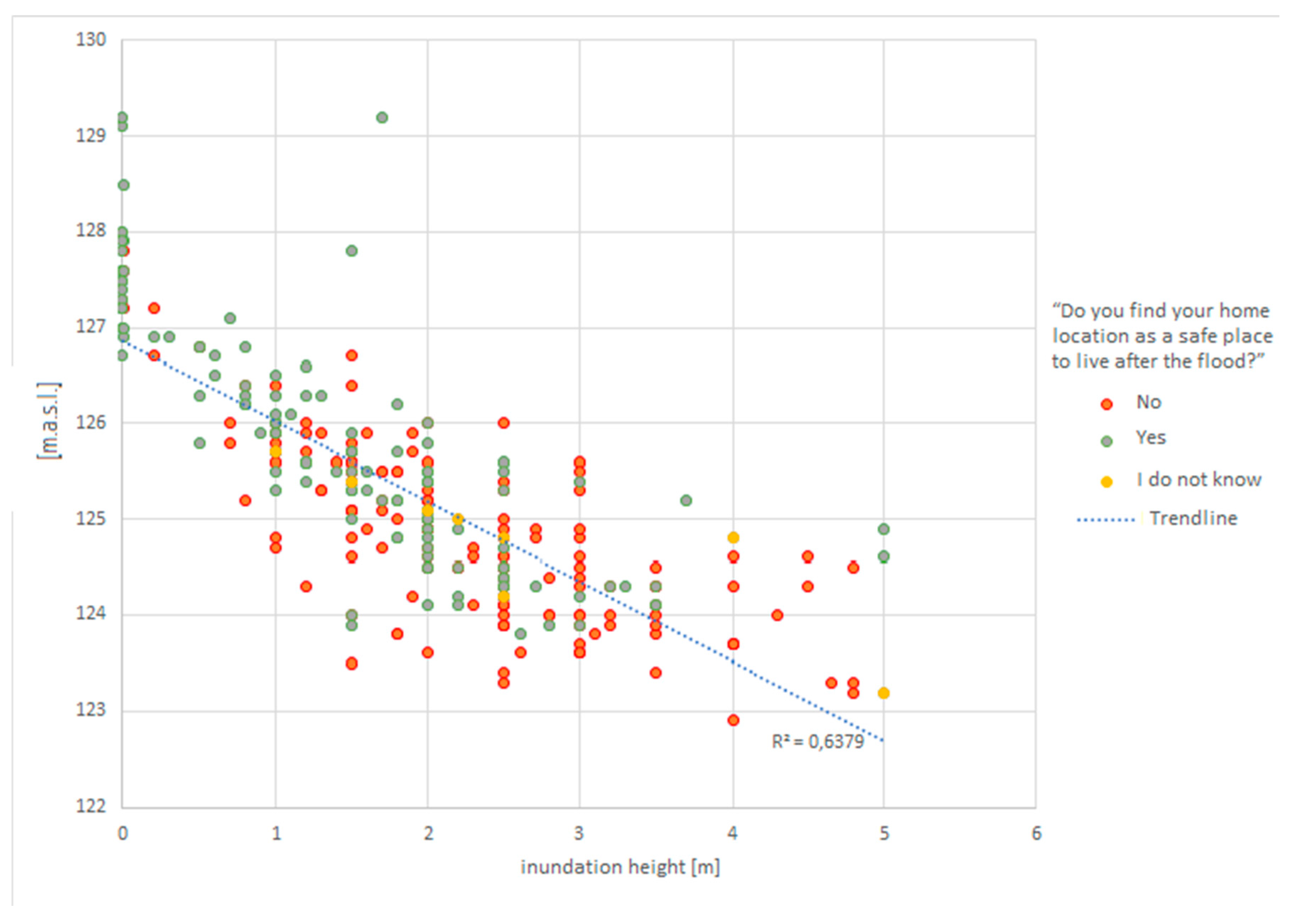
3.2.5. Correlation between floodplain height, inundation height and perception of safety
We juxtapose answers to question Nos 4 and 8 (Figure 2), presented above on the maps (Figure 8, Figure 11), with the elevation data from the DEM and present all these data on one graph (Figure 15). The values of higher inundation height (>2 m) clearly correspond with lower floodplain heights (<126 m a.s.l.) and these locations usually are perceived as not safe by people who live there. Locations above 126 m a.s.l. were inundated less than 2 m (according to the survey) and people consider these locations as safe places to live.
4. Discussion
The results of inundation height estimation (Figure 8, Figure 15) seem very reliable and can be verified by modelling, cf. [47]. From these results we can conclude that the 2010 flood is -still perceived as a very important event in the collective memory of the people living on the floodplain despite the twelve years that have passed since the flood happened. Less than half of interviewees (Figure 13 – group A) regard their home location as dangerous and susceptible to future flooding, which can be, interpreted as a “levee effect”, cf. Introduction. If the artificial levee were removed or not rebuilt in the breached section after the 2010 flood, the floodplain residents would be then more aware of the flood risk, we suppose. Risk denial would be then significantly lower, but the floodplain in the study reach is quite densely populated and reclaimed for agriculture, thus such consideration is theoretical only, because the study floodplain has to be embanked.
The calculation of economic losses includes livestock, crops and agricultural machinery only, because the study area is a type of rural community. We based the calculations on the data received from interviewees and on the prices from the 2010 year. As a result our calculation is possibly underestimated, especially if we take into account inflation which became significantly high in Poland in recent times [48,49].
The weak correlation between a value of flood loss and a distance from the breach is probably the result of large differences between the affected farms in livestock, crop area and agricultural machinery. Small, traditional farms dominated the Polish countryside, but since the EU accession a type of large farms has developed with specialization on agricultural production. We think that such a type of large farm is less resilient from flood and other geohazards.
An issue which might be very interesting for flood management authorities and researchers dealing with geohazards is the local perception of causes for the flooding. In our study (Figure 14) no one has indicated location on a floodplain in flood-prone area as a basic factor responsible for flooding. Most people who suffered from flooding (39%) overestimate the possible instability of artificial levees [22] and they completely neglect the regional geological setting, which we discuss at the end.
14 % of interviewees think that a better flood management system will protect their estates from flooding. This group can be regarded together with those above, however, because “flood management” is usually perceived by people living on the Polish riverine floodplains as river training works (controlling the flow in river by hydraulic structures), channel dredging and riparian vegetation clearance. We think that such attempts cannot diminish flood risk in the Vistula River valley.
A relatively high percentage of floodplain residents (17%) blamed state government or regional authorities for intentional breaching the levee. We found this 17% as a high percentage because this type of answer as the explanation of the levee breach can be regarded as a conspiracy theory. Interviewees usually linked the assumption of an intentional breach with political issues. Injecting politics into different regional or local problems is a feature of Polish society which distrusts governmental authority. It can be interpreted as an effect of historical experiences when Poland was divided in Russian, Prussian and Austrian partitions before WW1 or occupied and governed by Nazi Germany and Soviet Russia during WW2 and after. Government was perceived then as an alien force which aimed to exploit or even destroy the country[50].
We have identified two groups which tend to believe in an intentional levee breach: females ages 27 to 41 years old and males ages 67 to 71 years old (the age during the 2022 survey; in the results section the age was during the 2010 flood). We speculate that these two groups have experienced significant changes in their lives in recent times, which may have affected their flood collective memory.
Most of these women probably have had babies in the last decade. Mothers care for their children and expect safe conditions for their child to grown. In the collective perception of young mothers the 2010 flood can therefore be such a dramatic event that it must have been human caused.
Males in the 67-71 years age group have already reached retirement typical in rural Poland. This retirement is usually associated with the end of responsibility for the farmstead. It means that after the 2010 flood these men met several difficulties because their farmsteads were destroyed by the inundation and they were faced with post-flood recovery at an age of diminished capabilities. Our assumption can be confirmed by the fact that in the group of older men (i.e., 60-64 years old during the 2010 flood; they had retired shortly after the flood) no one linked the flood cause with an intentional levee breach.
A minority (10% only) thought that the high precipitation was as a cause of the 2010 flood. However the flood was induced by rainfall in distant headwaters of the Vistula River in the Carpathian Mountains. The Polish Lowlands and Upland (including the study area) did receive abnormal portions of rainfall as well before the flood.
The role of animals as a main cause of the levee breach is espoused by 6% of interviewees. They blamed beavers (Castor fiber), moles (Talpa europaea) or even foxes (Vulpes vulpes) and other creatures for flooding. Thirteen species of small mammals are reported to use sandy deposits of artificial levees in Poland as a habitat [51]. Male interviewees more often than females believe that the levee breach was induced by animals. It can be explained by the respondents more frequent outdoor activities of the men (than women) due to their job and recreation (most of the interviewees are farmers who performed field work and spend their free time outdoor, eg. fishing, that involves crossing the levees). Thus males have more opportunities to notice wild animals and holes made by these animals in the body of a levee.
These hydrotechnical structures can be weakened by small mammals, but they were in reality breached due to piping (suffosion) driven by high hydraulic gradient through an embankment [26,52,53]. The locations of levee breaches indicates that during a flood there is a natural tendency for the river to flow through crevasse channels associated with bedrock protrussions in the main river channel, widely documented in large Polish rivers [37,38,39,54,55,56,57,58].
On the basis of a simple remote sensing analysis we have ascertained that the geomorphological imprint of the 2010 levee breach in the study area is not visible in the field anymore. Similar traces of levee breaches (crevasse splays) formed during the previous catastrophic floods [[59] and [60]] cannot be found in the upper reaches of the Vistula River. Nevertheless the remnant landform of crevasse splay from the 2010 levee breach still exists in the Lower Vistula River [[29,45]] and appears to have remained almost unchanged since its deposition during the 2010 flood. We perceive such a landform as a natural flood mark which additionally denotes a levee breach location and permits us to envision the geomorphological aspect of the overbank flow.
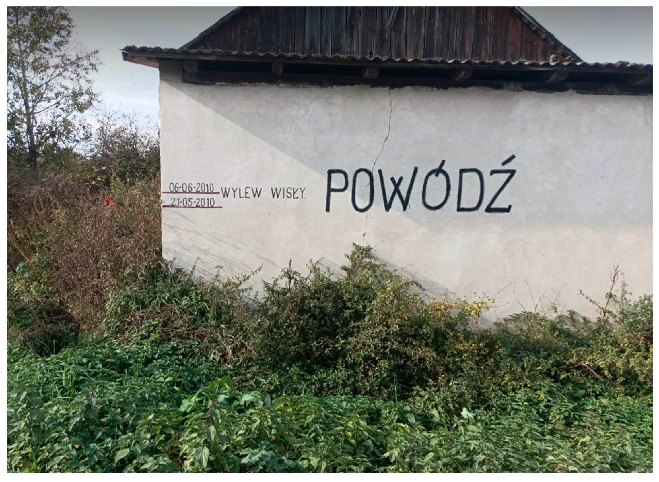
Flood marks, similarly to benchmarks in geodesy, are usually constructed to mark a point or a line which is referenced to the inundation level [61,62,63]. It is an important aspect of culture, because it enables one to hypothesize the flood extent and serves as a reminder that a flood may recur [22,64,65]. There was a flood mark on the church building in Wilków, which documents the 1833 flood [66,67].. A new flood mark from the 2010 flood was painted on the private house (Figure 16) and its date is stored in the flood marks data base – cf. [60].
Figure 16.
Flood mark on a private house in the Kłodnica settlement. Photo: Daria Krasiewicz, October 2022. In Polish: wylew Wisły - inundation from the Vistula River; powódź – flood. Location available at: http://openhydrology.org/maps/flood_mark/?zoom=17&lat=51.233081&lon=21.876681, cf. [68].
Figure 16.
Flood mark on a private house in the Kłodnica settlement. Photo: Daria Krasiewicz, October 2022. In Polish: wylew Wisły - inundation from the Vistula River; powódź – flood. Location available at: http://openhydrology.org/maps/flood_mark/?zoom=17&lat=51.233081&lon=21.876681, cf. [68].
Our study is limited by the fact that a half of the floodplain residents were suspicious and refused to take part in the survey. The loss estimation can be biased by several micro- and macro-economic factors.
5. Conclusions
Twelve years have passed since the flood and levee breach occurred in the study area, but these events are present in the area’s collective memory. The flood memory therefore cannot be regarded as short- lived for the people living on the inundated floodplain. However, among these people only 45% find their home location as unsafe and think that a flood may recur. This percentage should be higher. Its low value is associated with the “levee effect”.
A correlation between inundation height and floodplain height (elevation) exists and it slightly affects a sense of place (feeling of living in a safe place), because every floodplain is not a homogenous, flat surface. Some floodplain locations are less susceptible to flooding due to the non-fluvial origin (eg. remnant dunes). However, inundation of the floodplain through a levee breach usually is so dynamic and high that these differences do not play an important role for the inundation pattern.
None of the 287 interviewees indicates a geological or geomorphological cause of the flood even though they are common in the study area and have been discussed in many scientific papers. Scientific communication is removed from most of the residents as are flood experts. In the era of social media new ways of communication with society are easily available for academia, but few researchers can use these tools efficiently and even fewer promote their published papers. Thus, meaningful social impact of the scientific papers (measured by altmetrics) is still very low.
An intentional levee breach due to political issues was indicated by 49 interviewees, placing it as the second most popular cause of the levee breach in the collective flood memory of its residents. It can be viewed as an indicator that people distrust state authorities or that the flood was exploited by politicians.
On the basis of the study results and geomorphological literature about the study area, a final conclusion can be drawn: an explanation of the flood as an natural event that is scientifically valid and credible to the public needs more public outreach. To this end, the most challenging goal for flood science is an efficient communication of sophisticated knowledge to people who live in the flood-prone areas. How can we share our findings with the floodplain residents? The question remains open.
In the case of our study area we recommend educational action at a very local scale of the rural municipality (i.e., in Polish: gmina wiejska) or even more local – in the selected subdivisions of the gmina (in Polish: sołectwo).
Author Contributions
“Conceptualization, GW&DK; methodology, GW.&DK; software, DK&GW; validation, GW; formal analysis, GW; investigation, DK; resources, DK&GW; data curation, GW&DK.; writing—original draft preparation, GW&DK.; writing—review and editing, GW&DK.; visualization, DK&GW; supervision, GW; project administration, GW; funding acquisition, GW All authors have read and agreed to the published version of the manuscript.”
Funding
No external funding.
Data Availability Statement
The human research data cannot be published in full extent due to EU Regulation 2016/679 of the European Parliament and of the Council of 27 April 2016 on the protection of natural persons with regard to the processing of personal data and on the free movement of such data, and repealing Directive 95/46/EC (General Data Protection Regulation).
Acknowledgments
Philip Marshall (Fairbanks, Alaska) corrected the English in the revised version of the manuscript. 1st author acknowledges technical support in GIS analysis from Ignacy Kardel and Piotr Bartold. Grzegorz Wierzbicki is grateful to Tomasz Falkowski and Filip Bujakowski, who inspired the 2nd author to study the fluvial geomorphology of the Middle Vistula River and to visit the gmina Wilków a few months after the 2010 flood. People of the Wilków municipality shared photographs (Figure 4-6) of the flood. Marcin Górka suggested to the 2nd author to reference in the introduction the ancient civilizations which developed their cultures on floodplains. An Academic Editor and the Special Issue Editor gave some valuable comments and suggestions. We thank the Editors for efficient communication. We acknowledge remarks and suggestions received from three anonymous Reviewers.
Conflicts of Interest
“The authors declare no conflict of interest.”
References
- Jotheri, J.; Altaweel, M.; Tuji, A.; Anma, R.; Pennington, B.; Rost, S.; Watanabe, C. Holocene fluvial and anthropogenic processes in the region of Uruk in southern Mesopotamia. Quat. Int. 2018, 483, 57–69. [Google Scholar] [CrossRef]
- Forti, L.; Romano, L.; Celant, A.; D'Agostino, F.; Di Rita, F.; Jotheri, J.; Magri, D.; Mazzini, I.; Tentori, D.; Milli, S. The paleoenvironment and depositional context of the Sumerian site of Abu Tbeirah (Nasiriyah, southern Mesopotamia, Iraq). Quat. Res. 2022, 110, 165–183. [Google Scholar] [CrossRef]
- Malykhina, I.V. On the influence of geography on the development of accounting operations in Ancient Egypt. Vestnik Tomsk. Gos. Univ. Istor. 2015, 36, 59–62. [Google Scholar] [CrossRef]
- Toonen, W.H.J.; Cortebeeck, K.; Hendrickx, S.; Bader, B.; Peeters, J.; Willems, H. The hydro-geomorphological setting of the Old Kingdom town of al-Ashmūnayn in the Egyptian Nile Valley. Geoarchaeology 2021, 37, 267–283. [Google Scholar] [CrossRef]
- Giosan, L.; Clift, P.D.; Macklin, M.G.; Fuller, D.Q.; Constantinescu, S.; Durcan, J.A.; Stevens, T.; Duller, G.A.T.; Tabrez, A.R.; Gangal, K.; et al. Fluvial landscapes of the Harappan civilization. Proc. Natl. Acad. Sci. 2012, 109, 1688–1694. [Google Scholar] [CrossRef]
- Chaudhri, A.R.; Chopra, S.; Kumar, P.; Ranga, R.; Singh, Y.; Rajput, S.; Sharma, V.; Verma, V.K.; Sharma, R. Saraswati River in northern India (Haryana) and its role in populating the Harappan civilization sites—A study based on remote sensing, sedimentology, and strata chronology. Archaeol. Prospect. 2021, 28, 565–582. [Google Scholar] [CrossRef]
- Li, K.; Gao, W.; Wu, L.; Hu, H.; Gong, P.; Li, S.; Jin, R.; Si, Y. Spatial Expansion of Human Settlement during the Longshan Period (~4.5–~3.9 ka BP) and Its Hydroclimatic Contexts in the Lower Yellow River Floodplain, Eastern China. Land 2021, 10, 712. [Google Scholar] [CrossRef]
- Gao, W.; Hu, H.; Hou, W.; Zhang, P.; Gong, P.; Jia, W.; Liu, X.; Li, K. The Spatiotemporal Patterns of Human Settlement during the Longshan and Erlitou Periods in Relation to Extreme Floods and Subsistence Strategy in the Upper and Middle Qin River Reaches, Central China. Land 2022, 11, 1088. [Google Scholar] [CrossRef]
- B. Solís-Castillo, M. Arturo Ortiz-Pérez, and E. Solleiro-Rebolledo, “Unidades geomorfológico-ambientales de las Tierras Bajas Mayas deTabasco-Chiapas en el río Usumacinta: Un registro de los procesosaluviales y pedológicos durante el Cuaternario,” 2014.
- Luzzadder-Beach, S.; Beach, T. Arising from the Wetlands: Mechanisms and Chronology of Landscape Aggradation in the Northern Coastal Plain of Belize. Ann. Assoc. Am. Geogr. 2009, 99, 1–26. [Google Scholar] [CrossRef]
- Ramírez-Núñez, C.; Cyphers, A.; Parrot, J.-F.; Höfle, B. MULTIDIRECTIONAL INTERPOLATION OF LIDAR DATA FROM SOUTHERN VERACRUZ, MEXICO: IMPLICATIONS FOR EARLY OLMEC SUBSISTENCE. Anc. Mesoam. 2019, 30, 385–398. [Google Scholar] [CrossRef]
- Stoner, W.D.; Stark, B.L. Distributed Urban Networks in the Gulf Lowlands of Veracruz. J. Archaeol. Res. 2022, 31, 449–501. [Google Scholar] [CrossRef]
- Wotchoko, P.; Bardintzeff, J.-M.; Itiga, Z.; Nkouathio, D.G.; Guedjeo, C.S.; Ngnoupeck, G.; Dongmo, A.K.; Wandji, P. Geohazards (floods and landslides) in the Ndop plain, Cameroon volcanic line. Open Geosci. 2016, 8, 429–449. [Google Scholar] [CrossRef]
- Buchenrieder, G.; Brandl, J.; Balgah, A.R. The Perception of Flood Risks: A Case Study of Babessi in Rural Cameroon. Int. J. Disaster Risk Sci. 2021, 12, 1–21. [Google Scholar] [CrossRef]
- Li, W.-J.; Yu, S.-Y.; Pan, J.; Cao, X.; Chen, Y.; Wang, Y. A 2000-year documentary record of levee breaches on the lower Yellow River and their relationship with climate changes and human activities. Holocene 2020, 31, 333–345. [Google Scholar] [CrossRef]
- Araya, K.; Muñoz, P.; Dezileau, L.; Maldonado, A.; Campos-Caba, R.; Rebolledo, L.; Cardenas, P.; Salamanca, M. Extreme Sea Surges, Tsunamis and Pluvial Flooding Events during the Last ~1000 Years in the Semi-Arid Wetland, Coquimbo Chile. Geosciences 2021, 12, 135. [Google Scholar] [CrossRef]
- Alcayaga, H.; Soto-Alvarez, M.; Laronne, J.B.; Caamaño, D.; Mao, L.; Urrutia, R. Runoff volume and sediment yield from an endorheic watershed generated by rare rainfall events in the Atacama Desert. Geomorphology 2022, 400, 108107. [Google Scholar] [CrossRef]
- Bach, E.; Mote, S.; Krishnamurthy, V.; Sharma, A.S.; Ghil, M.; Kalnay, E. Ensemble Oscillation Correction (EnOC): Leveraging oscillatory modes to improve forecasts of chaotic systems. J. Clim. 2021, 34, 5673–5686. [Google Scholar] [CrossRef]
- Ray, A.; Rakshit, S.; Basak, G.K.; Dana, S.K.; Ghosh, D. Understanding the origin of extreme events in El Niño southern oscillation. Phys. Rev. E 2020, 101, 062210. [Google Scholar] [CrossRef]
- Chang, H.-S.; Su, Q.; Jheng, D.-C. Comparing the spatial patterns of flooding and individual risk perception: A case study of Yunlin, Taiwan. Urban Clim. 2022, 45. [Google Scholar] [CrossRef]
- Mazzoleni, M.; Brandimarte, L. Modelling flood awareness in floodplain dynamics. Hydrol. Sci. J. 2023, 68, 604–613. [Google Scholar] [CrossRef]
- Ridolfi, E.; Mondino, E.; Di Baldassarre, G. Hydrological risk: modeling flood memory and human proximity to rivers. Hydrol. Res. 2020, 52, 241–252. [Google Scholar] [CrossRef]
- van Heel, B.F.; Born, R.J.v.D. Studying residents’ flood risk perceptions and sense of place to inform public participation in a Dutch river restoration project. J. Integr. Environ. Sci. 2020, 17, 35–55. [Google Scholar] [CrossRef]
- Fanta, V.; Šálek, M.; Sklenicka, P. How long do floods throughout the millennium remain in the collective memory? Nat. Commun. 2019, 10, 1105. [Google Scholar] [CrossRef] [PubMed]
- Brandolini, P.; Del Monte, M.; Faccini, F.; Cattoor, B.; Zwoliński, Z.; Smith, M. Geomorphological mapping in urban areas. J. Maps 2021, 17, 1–5. [Google Scholar] [CrossRef]
- Wierzbicki, G.; Ostrowski, P.; Bartold, P.; Bujakowski, F.; Falkowski, T.; Osiński, P. Urban geomorphology of the Vistula River valley in Warsaw. J. Maps 2021, 17, 170–185. [Google Scholar] [CrossRef]
- Forno, M.G.; Gianotti, F. The Turin fluvial terraces as evidence of the new Holocene setting of the Po River. J. Maps 2020, 17, 75–85. [Google Scholar] [CrossRef]
- Łajczak, A.; Zarychta, R.; Wałek, G. Changes in the topography of Krakow city centre, Poland, during the last millennium. J. Maps 2020, 17, 186–193. [Google Scholar] [CrossRef]
- Zwoliński, Z.; Jasiewicz, J.; Mazurek, M.; Hildebrandt-Radke, I.; Makohonienko, M. Geohazards and Geomorphological Setting in Poznań Urban Area, Poland. J. Maps 2021, 17, 202–214. [Google Scholar] [CrossRef]
- E. P. Anderson et al., “Understanding rivers and their social relations: A critical step to advance environmental water management,” Wiley Interdisciplinary Reviews: Water, vol. 6, no. 6. John Wiley and Sons Inc, Nov. 01, 2019. doi: 10.1002/WAT2.1381. [CrossRef]
- Blöschl, G.; Hall, J.; Parajka, J.; Perdigão, R.A.P.; Merz, B.; Arheimer, B.; Aronica, G.T.; Bilibashi, A.; Bonacci, O.; Borga, M.; et al. Changing climate shifts timing of European floods. Science 2017, 357, 588–590. [Google Scholar] [CrossRef]
- Venegas-Cordero, N.; Kundzewicz, Z.W.; Jamro, S.; Piniewski, M. Detection of trends in observed river floods in Poland. J. Hydrol. Reg. Stud. 2022, 41, 101098. [Google Scholar] [CrossRef]
- Lindenschmidt, K.-E. RIVICE—A Non-Proprietary, Open-Source, One-Dimensional River-Ice Model. Water 2017, 9, 314. [Google Scholar] [CrossRef]
- Solon, J.; Borzyszkowski, J.; Bidłasik, M.; Richling, A.; Badora, K.; Balon, J.; Brzezińska-Wójcik, T.; Chabudziński, Ł.; Dobrowolski, R.; Grzegorczyk, I.; et al. Physico-geographical mesoregions of Poland: Verification and adjustment of boundaries on the basis of contemporary spatial data. Geogr. Pol. 2018, 91, 143–170. [Google Scholar] [CrossRef]
- Goudie A, “ALPHABETICAL GLOSSARY OF GEOMORPHOLOGY,” Int. Assoc. Geomorphol., no. 1, pp. 1–84, Jul. 2014.
- Wierzbicki G., Ostrowski P., Samulski M., and Bujakowski F., “The impact of geological setting into a dynamics of extreme floods – a case study of the 2010 flood event in the vistula valley ,” Infrastruct. Ecol. Rural areas, pp. 27–41, 2012.
- Wierzbicki, G.; Ostrowski, P.; Falkowski, T.; Mazgajski, M. Geological setting control of flood dynamics in lowland rivers (Poland). Sci. Total. Environ. 2018, 636, 367–382. [Google Scholar] [CrossRef] [PubMed]
- Falkowski T., “Alluvial bottom geology inferred as a factor controlling channel flow along the Middle Vistula River, Poland.,” Geol. Q., vol. 51, no. 1, pp. 91–102, 2007.
- Falkowski T., “Factors of Natural Stability of theMiddle Vistula River Channel Zones,” SGGW Warszawa, 2006.
- Wierzbicki, G.; Ostrowski, P.; Mazgajski, M.; Bujakowski, F. Using VHR multispectral remote sensing and LIDAR data to determine the geomorphological effects of overbank flow on a floodplain (the Vistula River, Poland). Geomorphology 2013, 183, 73–81. [Google Scholar] [CrossRef]
- Kallio, H.; Pietilä, A.-M.; Johnson, M.; Kangasniemi, M. Systematic methodological review: developing a framework for a qualitative semi-structured interview guide. J. Adv. Nurs. 2016, 72, 2954–2965. [Google Scholar] [CrossRef] [PubMed]
- Kurczyński Z. and Bakuła K., “Generowanie referencyjnego numerycznego modelu terenu o zasięgu krajowym w oparciu o lotnicze skanowanie laserowe w projekcie ISOK,” Arch. Fotogram. Kartogr. i Teledetekcji , pp. 59–68, 2013.
- Gałaś, A. Impact of volcanic eruptions on the environment and climatic conditions in the area of Poland (Central Europe). Earth-Science Rev. 2016, 162, 58–64. [Google Scholar] [CrossRef]
- Bissolli, P.; Friedrich, K.; Rapp, J.; Ziese, M. Flooding in eastern central Europe in May 2010 - reasons, evolution and climatological assessment. Weather 2011, 66, 147–153. [Google Scholar] [CrossRef]
- Cebulak E., Kilar P., Milanówka D., Mizera M., and Pyrc R., “Wysokość, natężenie i przestrzenny rozkład opadów atmosferycznych [W:] Dorzecze Wisły. Monografia powodzi maj-czerwiec 2010. Red. M. Maciejewski, M.S. Ostojski, T. Walczykiewicz.,” IMGW-PIB Warszawa, pp. 27–41, 2011.
- Magnuszewski, A.; Gutry-Korycka, M.; Mikulski, Z. Historyczne i współczesne warunki przepływu wód wielkich Wisły w Warszawie. Część I. Gospod. Wodna 2012, 1, 9–18. [Google Scholar]
- Rizzo, C.; Maranzoni, A.; D’oria, M. Probabilistic mapping and sensitivity assessment of dam-break flood hazard. Hydrol. Sci. J. 2023, 68, 1–19. [Google Scholar] [CrossRef]
- Macias, P.; Stelmasiak, D.; Szafranek, K. Nowcasting food inflation with a massive amount of online prices. Int. J. Forecast. 2023, 39, 809–826. [Google Scholar] [CrossRef]
- Wolski, R. Residential Real Estate as a Potential Hedge of Capital Against Inflation. Real Estate Manag. Valuat. 2023, 31, 36–42. [Google Scholar] [CrossRef]
- Chodakiewicz Marek Jan, Intermarium. The Land between the Black and Baltic Seas Transaction Publishers, vol. 22. 2012.
- Pawlat H., Adamczewska-Andrzejewska K., Mackin-Rogalska R., and Nabaglo L., “Przeciwdziałanie występowaniu i zwalczanie drobnych ssaków zasiedlających wały przeciwpowodziowe,” Wiadomości Inst. Melior. i Użytków Zielonych, vol. 17, no. 1, 1992.
- Bujakowski, F.; Falkowski, T. Hydrogeological Analysis Supported by Remote Sensing Methods as A Tool for Assessing the Safety of Embankments (Case Study from Vistula River Valley, Poland). Water 2019, 11, 266. [Google Scholar] [CrossRef]
- Bujakowski, F.; Falkowski, T.; Podlasek, A.; Ostrowski, P. Real-Time Groundwater Dynamics Verification in the Embankment’s Substrate during the Transition of a Flood Wave. Water 2022, 14, 3986. [Google Scholar] [CrossRef]
- Falkowski T. and Popek Z., “Zones of the ice-jam formation on the Middle Vistula River reach in relation to variable of river valley morphology,” Ann. Warsaw Univ. Life Sci. – SGGW L. Reclamation., vol. 30, pp. 77–90, 2000.
- Falkowski T., “The application of geomorphological analysis of the Vistula River, Poland in the evaluation of the safety of regulation structures,” ACTA Geol. Pol., vol. 57, no. 3, pp. 377–389, 2007.
- Falkowski, T. Basement of the alluvia influence on the channel pattern in example of selected reach of the Pilica River. Ann. Wars. Univ. Life Sci. - SGGW. Land Reclam. 2010, 42, 93–104. [Google Scholar] [CrossRef]
- Ostrowski, P.; Falkowski, T. Application of Remote Sensing Methods to Study the Relief of Lowland River Valleys with a Complex Geological Structure—A Case Study of the Bug River. Water 2020, 12, 487. [Google Scholar] [CrossRef]
- Ostrowski, P.; Falkowski, T.; Utratna-Żukowska, M. The effect of geological channel structures on floodplain morphodynamics of lowland rivers: A case study from the Bug River, Poland. CATENA 2021, 202, 105209. [Google Scholar] [CrossRef]
- P. Gębica and T. Sokołowski, “SEDIMENTOLOGICAL INTERPRETATION OF CREVASSE SPLAYS FORMED DURING THE EXTREME 1997 FLOOD IN THE UPPER VISTULA RIVER VALLEY (SOUTH POLAND),” 2001.
- Gębica P. and Sokołowski T., “CREVASSING OF AN INLAND DUNE DURING THE 1998 FLOOD IN THE UPPER VISTULA RIVER VALLEY (SOUTH POLAND),” 2002.
- Deschaux, J. Flood-related Impacts on Cultural Heritage. In Floods; Elsevier: Amsterdam, The Netherlands, 2017; pp. 53–72. [Google Scholar] [CrossRef]
- Song, S.; Wang, S.; Fu, B.; Dong, Y.; Liu, Y.; Chen, H.; Wang, Y. Improving representation of collective memory in socio-hydrological models and new insights into flood risk management. J. Flood Risk Manag. 2020, 14. [Google Scholar] [CrossRef]
- Garde-Hansen, J.; McEwen, L.; Holmes, A.; Jones, O. Sustainable flood memory: Remembering as resilience. Mem. Stud. 2017, 10, 384–405. [Google Scholar] [CrossRef]
- Cruz-Bello, G.M.; Alfie-Cohen, M. Capturing flood community perceptions for social vulnerability reduction and risk management planning. Environ. Sci. Policy 2022, 132, 190–197. [Google Scholar] [CrossRef]
- Szczepanek, R.; Toś, C.; Bodziony, M. Temporary flood marks proposal: What we learned after losing the baroque artifact from Cracow, Poland. Int. J. Disaster Risk Reduct. 2022, 74, 102942. [Google Scholar] [CrossRef]
- Małgorzata Dziechciarz, “Historyczne powodzie na Wiśle Lubelskiej w świetle znaków i tablic wielkich wód,” 2010.
- Szczepanek, R. A Deep Learning Model of Spatial Distance and Named Entity Recognition (SD-NER) for Flood Mark Text Classification. Water 2023, 15, 1197. [Google Scholar] [CrossRef]
- Szczepanek R, “‘Flood marks’. [OpenHydrology]. http://openhydrology.org/maps/flood_mark/?zoom=17&lat=51.233081&lon=21.876681 (dostęp 5 cze 2023).,” 2023.
Figure 1.
Location of the study area (gmina Wilków) on the ALS DEM. On the upper map: yellow colour indicates upland higher than 300 m a.s.l.; red colour indicates mountains higher than 600 m a.s.l. up to 2.500 m a.s.l.
Figure 1.
Location of the study area (gmina Wilków) on the ALS DEM. On the upper map: yellow colour indicates upland higher than 300 m a.s.l.; red colour indicates mountains higher than 600 m a.s.l. up to 2.500 m a.s.l.
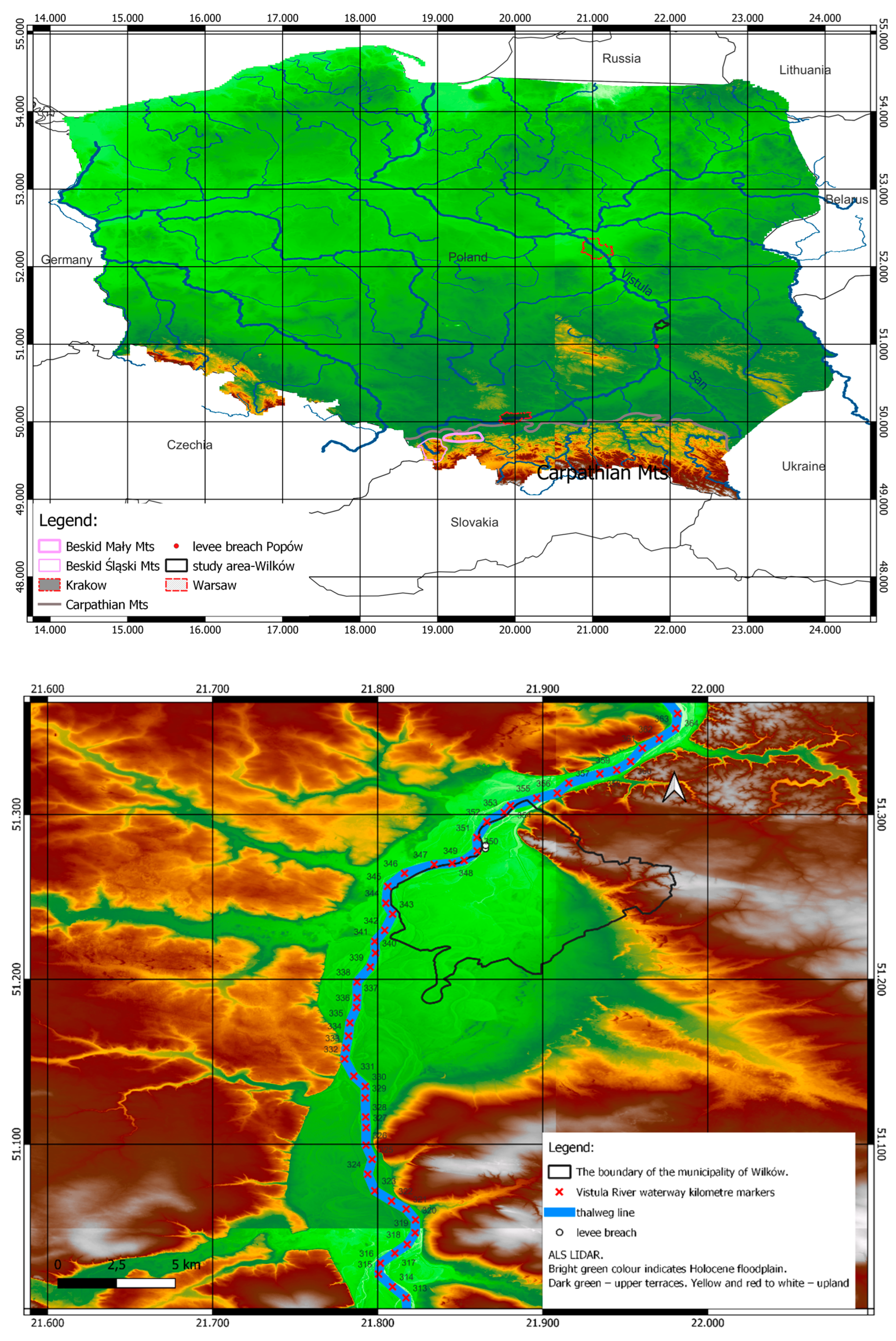
Figure 2.
The questionnaire used for the semi-structured interviews. The Polish version only was used in the field as all the interviewees were Poles.
Figure 2.
The questionnaire used for the semi-structured interviews. The Polish version only was used in the field as all the interviewees were Poles.
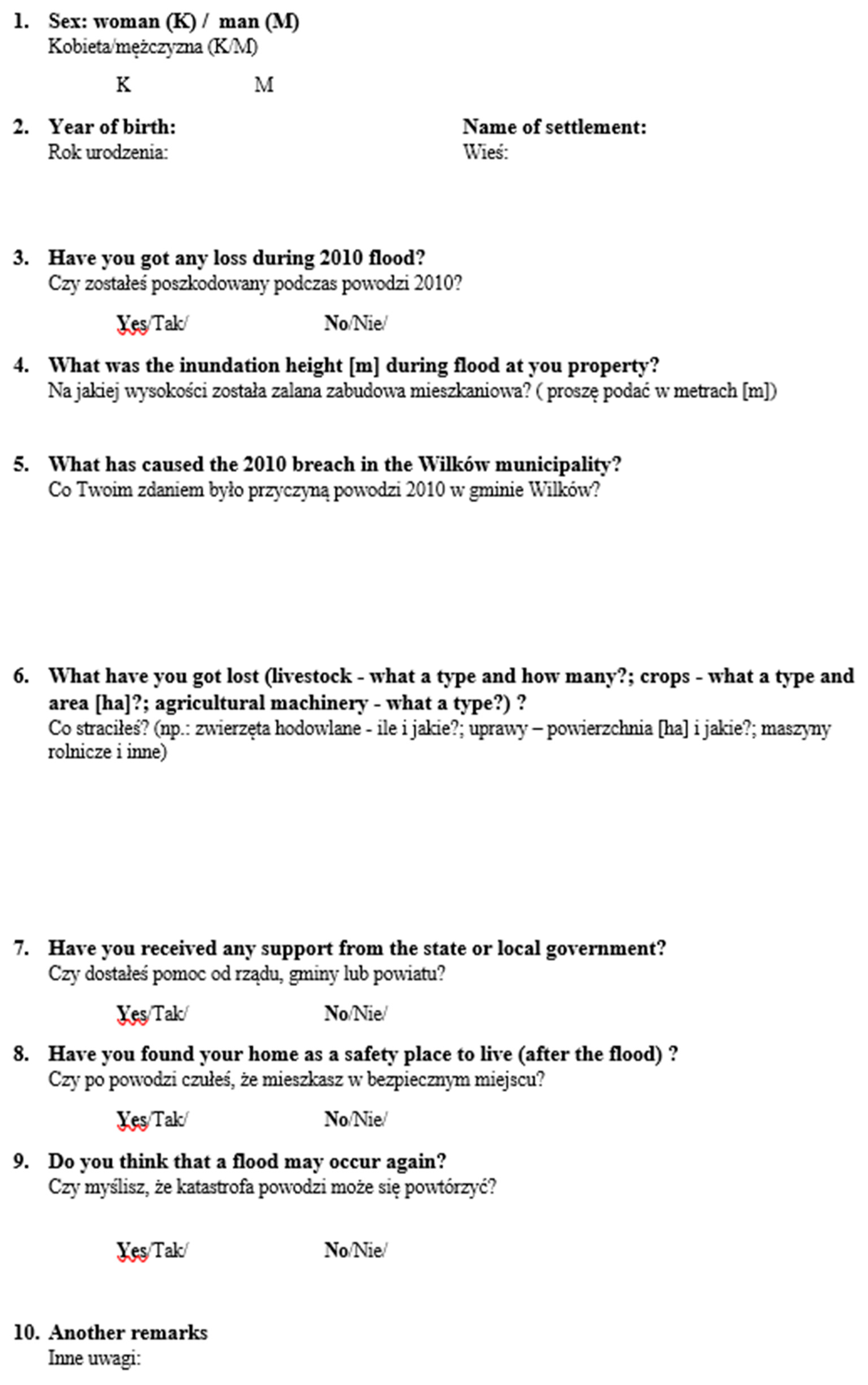
Figure 3.
Stage hydrograph from the Puławy-Azoty gauging station with telemetric system. Location 25 km downstream from the study area. Data source: IMGW-PIB (Institute of Meteorology and Water Management) & Wierzbicki et al. 2018. Orange line – warning stage. Grey line- alert stage. Dots – levee breaches.
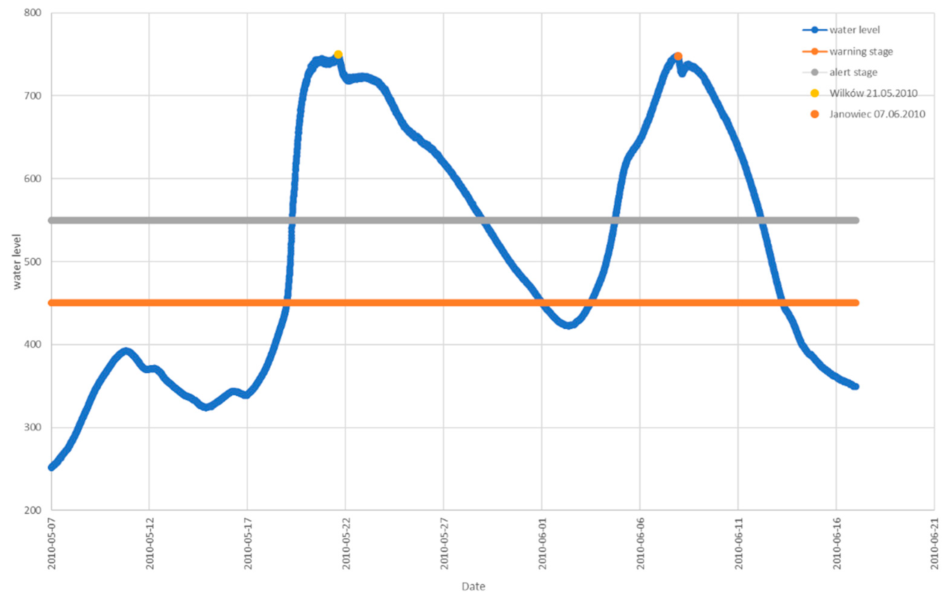
Figure 4.
Church in the Wilków settlement during 1st floodwave. Photo: Wilków anonymous inhabitant, May 2010.
Figure 4.
Church in the Wilków settlement during 1st floodwave. Photo: Wilków anonymous inhabitant, May 2010.
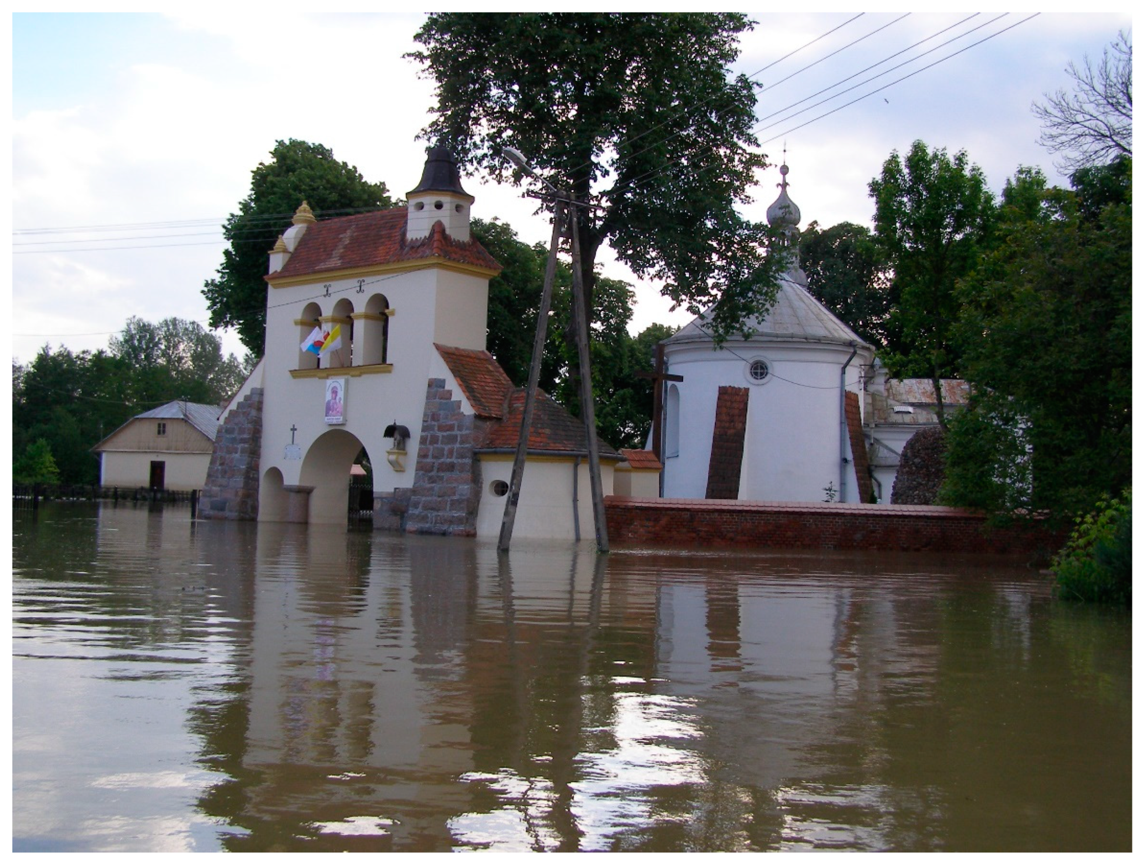
Figure 5.
Main street in the Wilków village during 1st floodwave. Photo: the Wilków anonymous inhabitant, May 2010.
Figure 5.
Main street in the Wilków village during 1st floodwave. Photo: the Wilków anonymous inhabitant, May 2010.
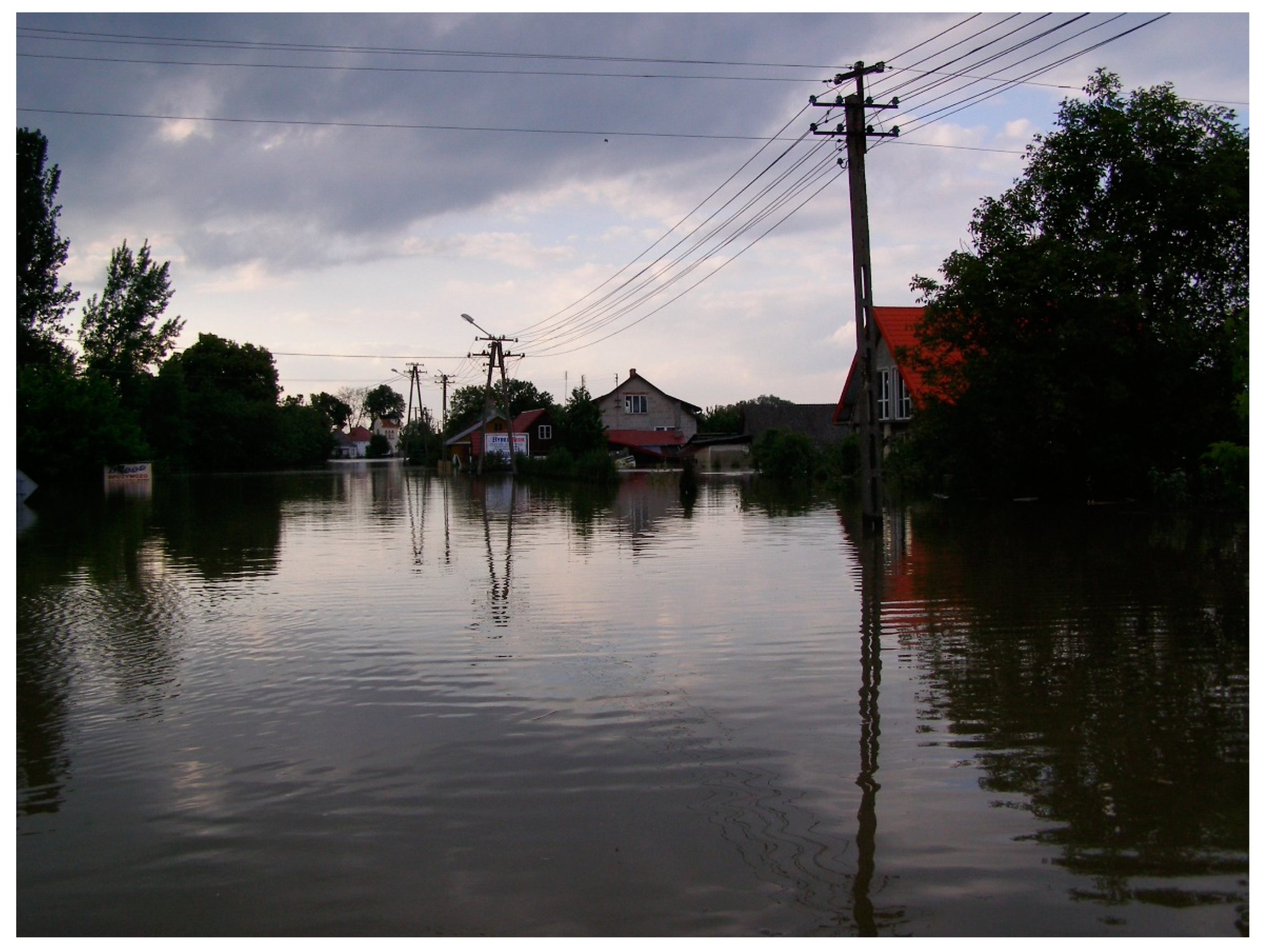
Figure 6.
Main road to the Wilków settlement during 1st floodwave. Photo: the Wilków anonymous inhabitant, May 2010.
Figure 6.
Main road to the Wilków settlement during 1st floodwave. Photo: the Wilków anonymous inhabitant, May 2010.
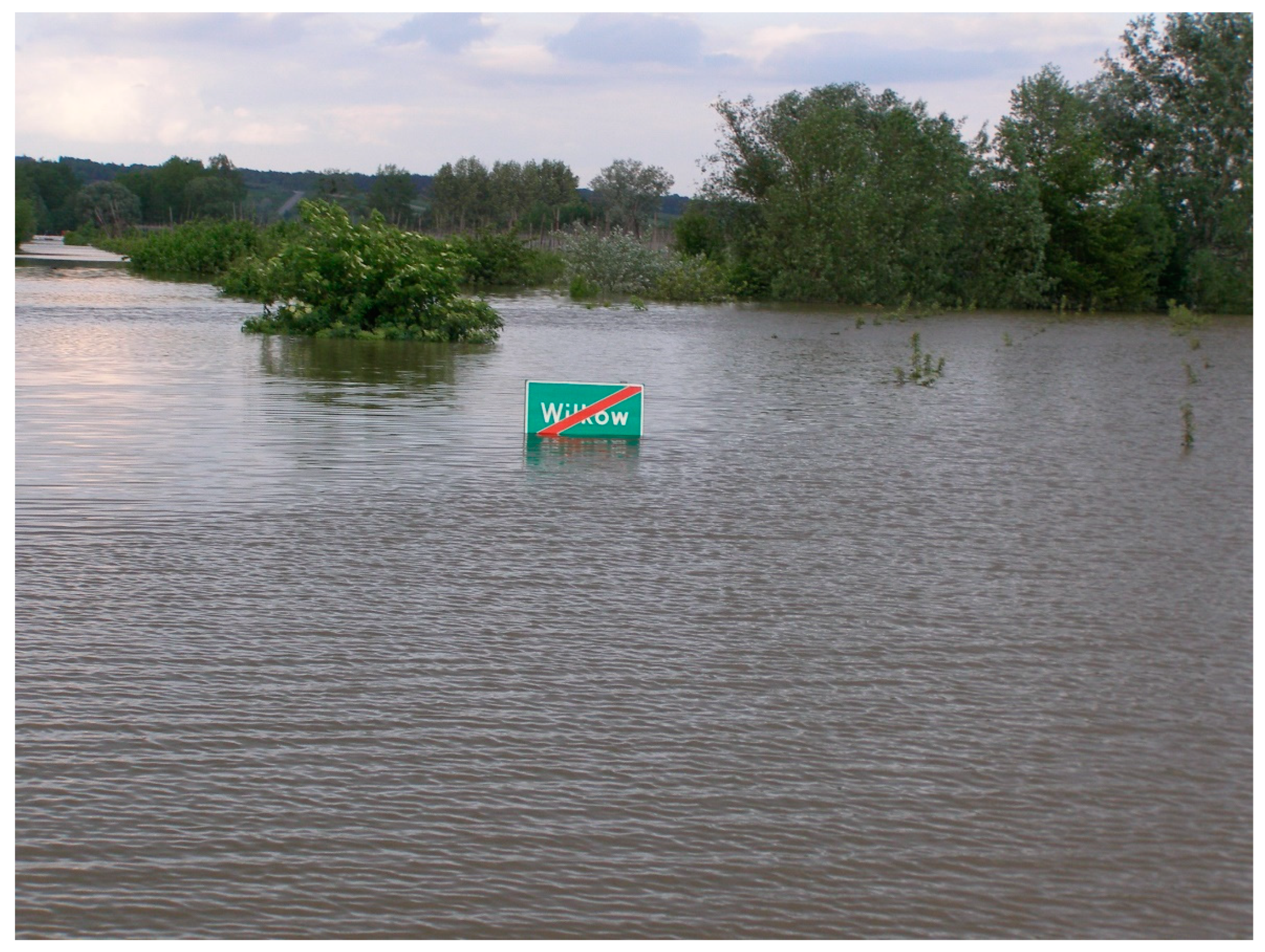
Figure 7.
Population pyramid of the interviewees. The age is given for the year when the flood occurs – AD 2010.
Figure 7.
Population pyramid of the interviewees. The age is given for the year when the flood occurs – AD 2010.
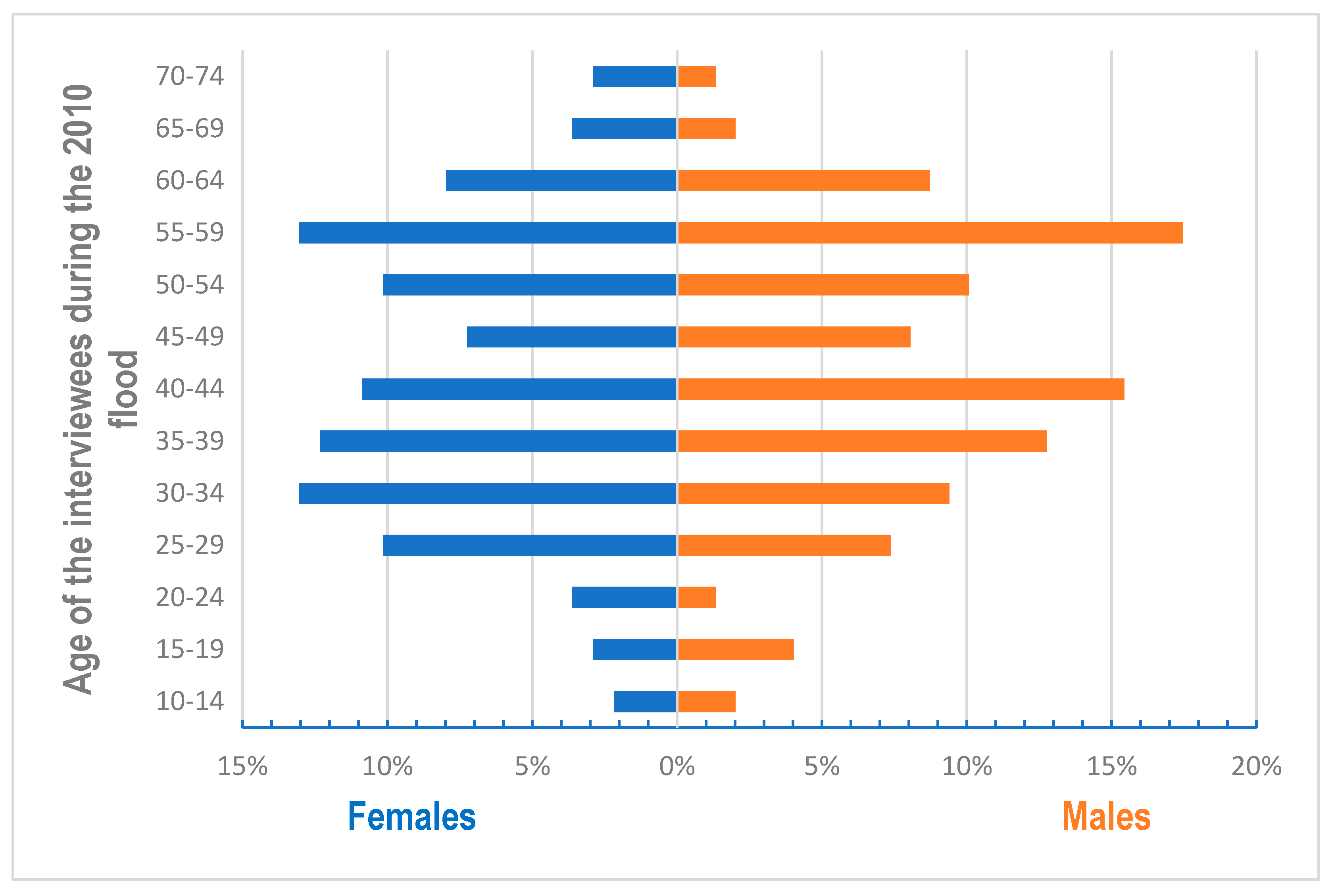
Figure 8.
Inundation height according to the interviewees.
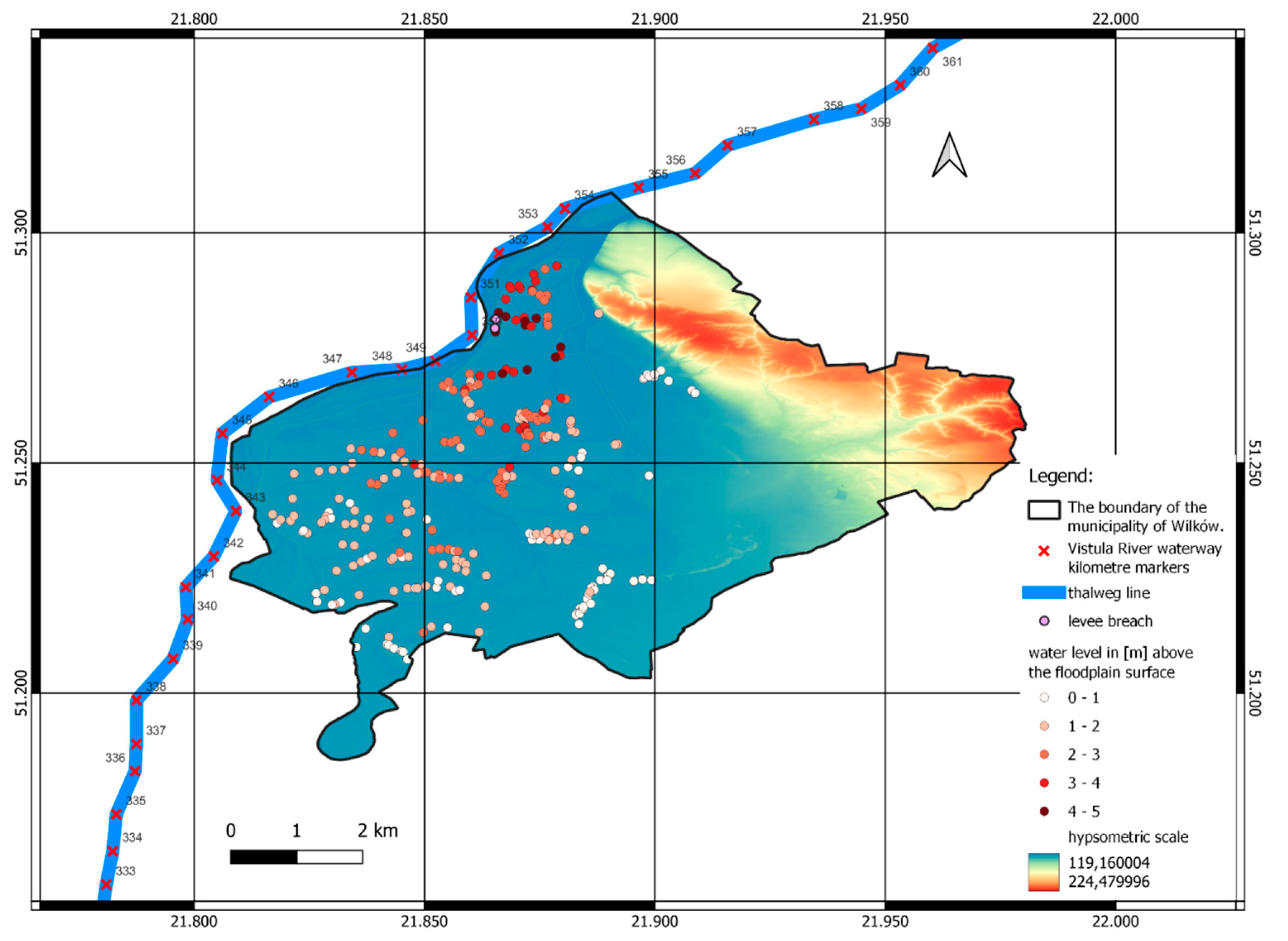
Figure 9.
Economic losses according to the interviewees.
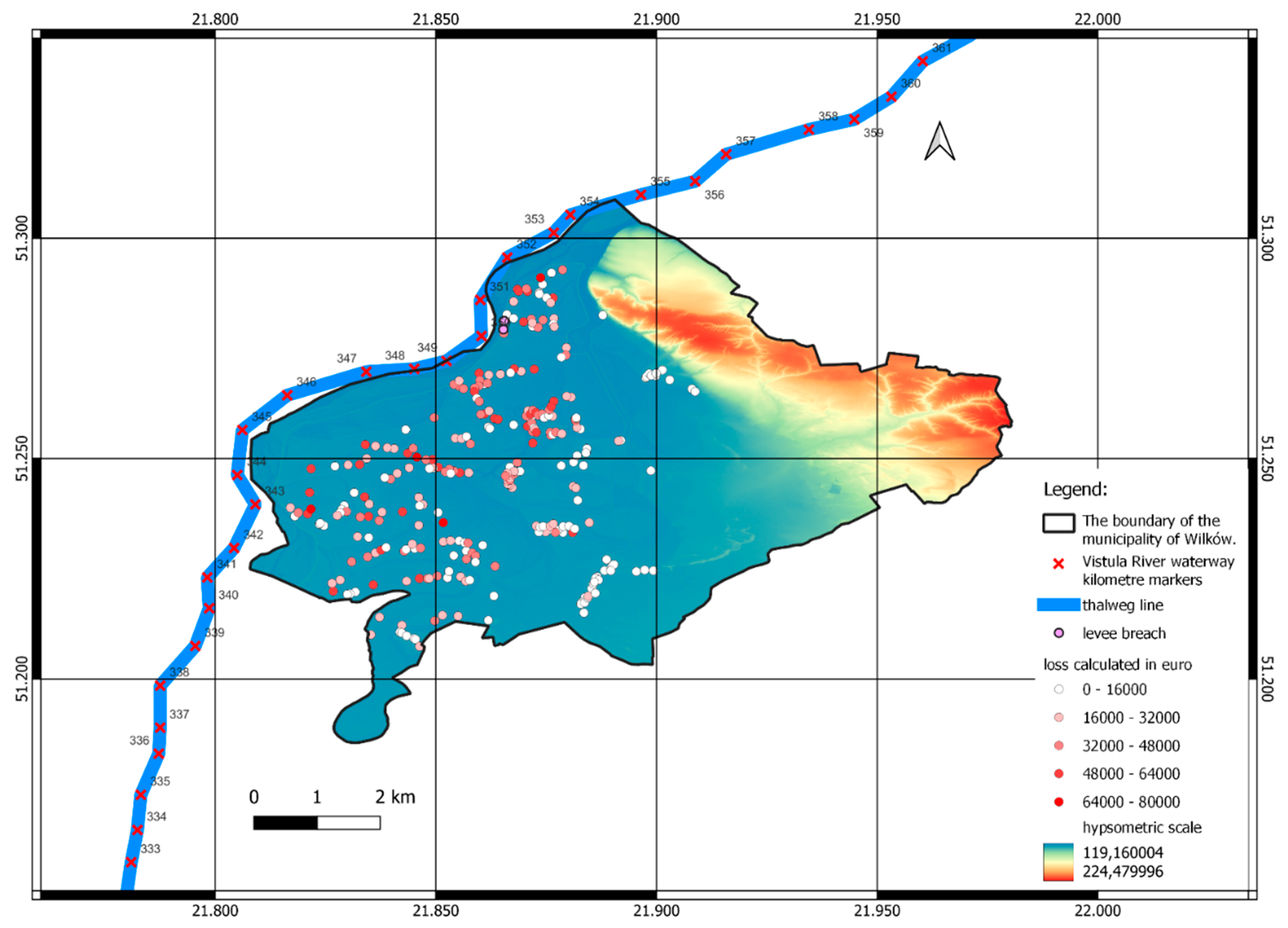
Figure 10.
Correlation between the economic losses due to the 2010 flood and the distance from the levee breach.
Figure 10.
Correlation between the economic losses due to the 2010 flood and the distance from the levee breach.
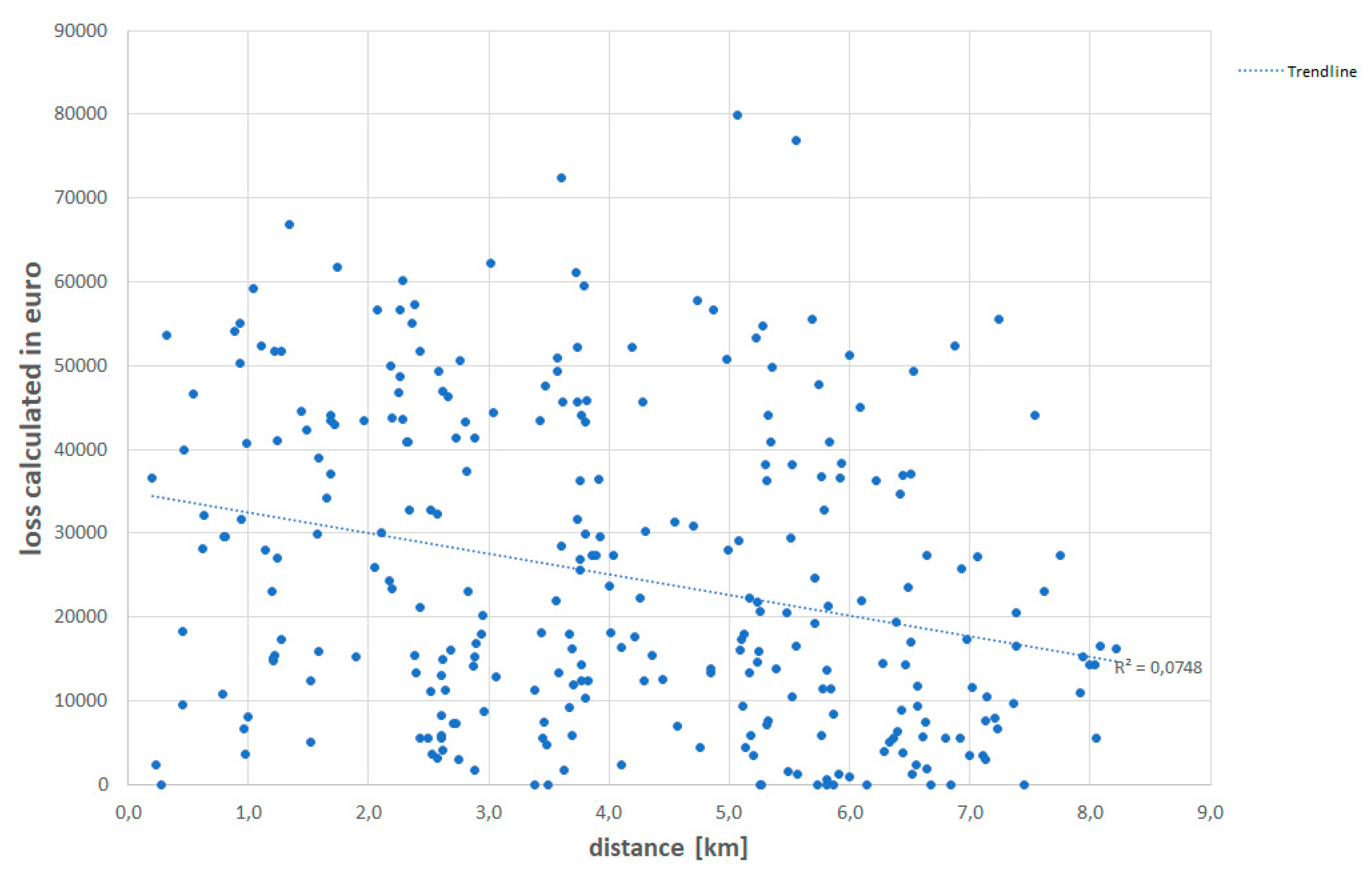
Figure 11.
Sense of place as answers to the question: Do you find your home location as a safe place to live after the flood?
Figure 11.
Sense of place as answers to the question: Do you find your home location as a safe place to live after the flood?
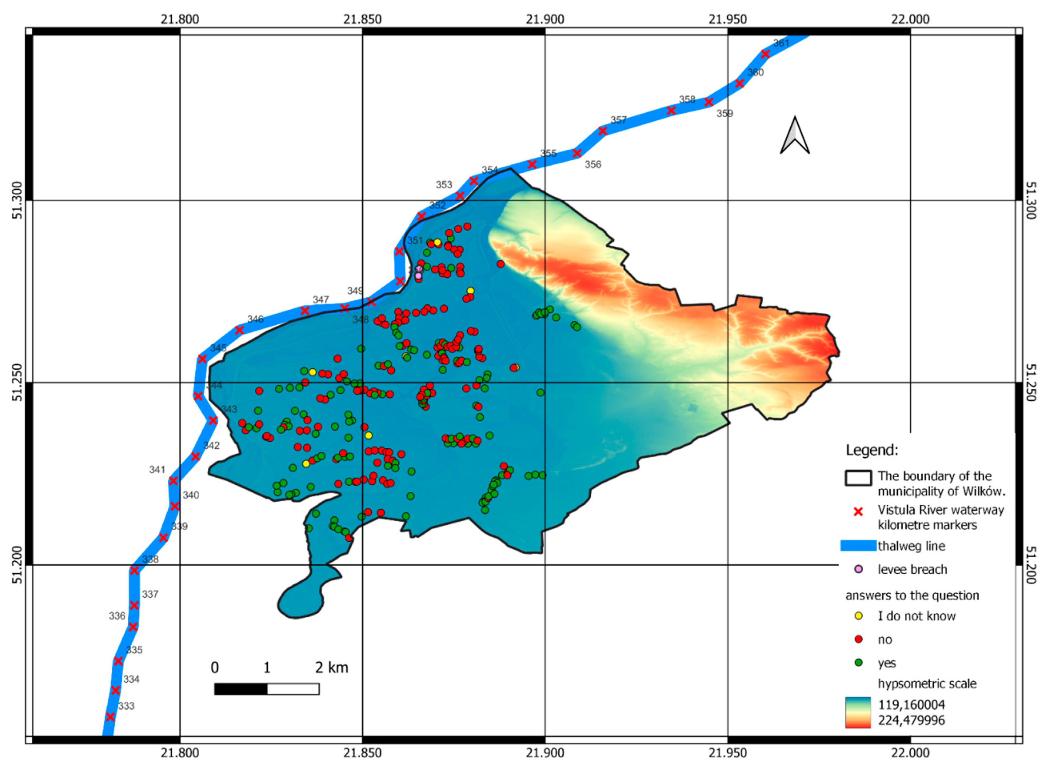
Figure 12.
Flood risk perception as answers to the question: Will a flood recur?
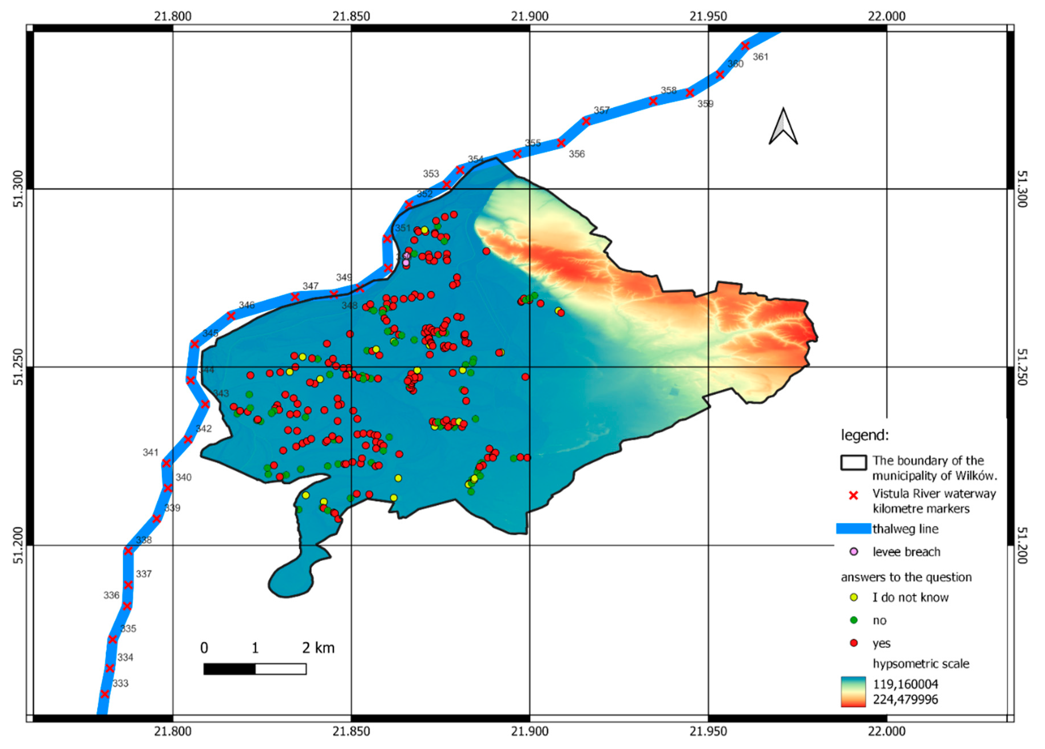
Figure 13.
– Group A. Interviewees (127) expecting flood recurrence and finding location of their home as unsafe place to live. Group B. Other interviewees who feel safe living on floodplain (69), or not expecting flood recurrence (65), or without clear answer (they do not know) (26).
Figure 13.
– Group A. Interviewees (127) expecting flood recurrence and finding location of their home as unsafe place to live. Group B. Other interviewees who feel safe living on floodplain (69), or not expecting flood recurrence (65), or without clear answer (they do not know) (26).
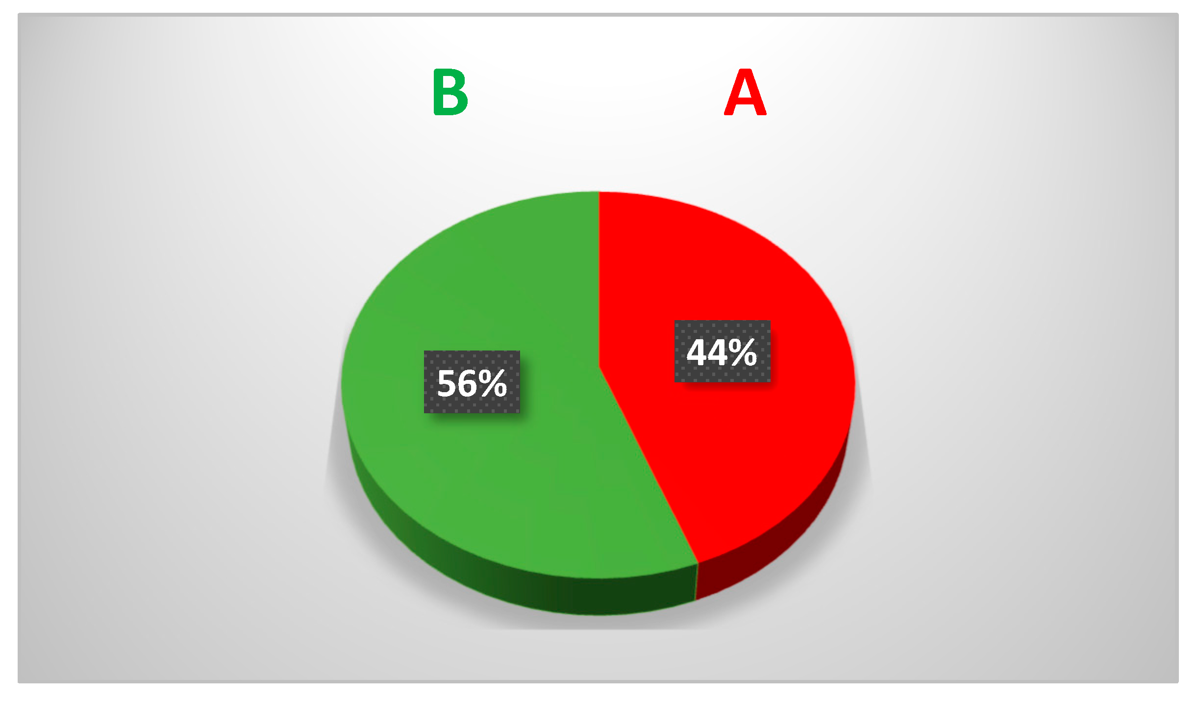
Figure 14.
Causes of the 2010 flood in the study area according to the interviewees.
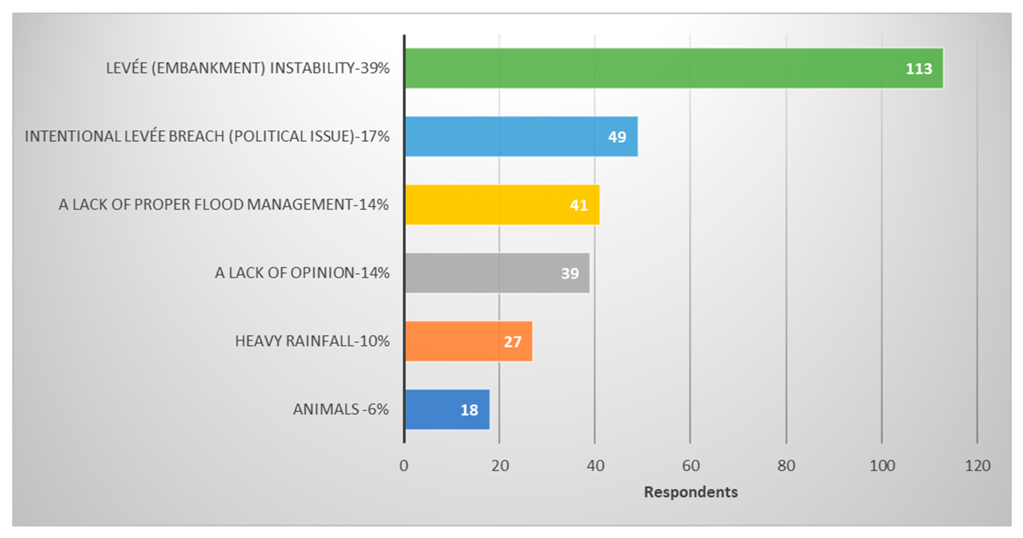
Figure 15.
Correlation between inundation height [m] (a value given by the interviewees and floodplain elevation read from the DEM [m a.s.l.]. Additionally answer to the question from Figure 11 is presented: “Do you find your home location as a safe place to live after the flood”?
Figure 15.
Correlation between inundation height [m] (a value given by the interviewees and floodplain elevation read from the DEM [m a.s.l.]. Additionally answer to the question from Figure 11 is presented: “Do you find your home location as a safe place to live after the flood”?
Disclaimer/Publisher’s Note: The statements, opinions and data contained in all publications are solely those of the individual author(s) and contributor(s) and not of MDPI and/or the editor(s). MDPI and/or the editor(s) disclaim responsibility for any injury to people or property resulting from any ideas, methods, instructions or products referred to in the content. |
© 2023 by the authors. Licensee MDPI, Basel, Switzerland. This article is an open access article distributed under the terms and conditions of the Creative Commons Attribution (CC BY) license (http://creativecommons.org/licenses/by/4.0/).
Copyright: This open access article is published under a Creative Commons CC BY 4.0 license, which permit the free download, distribution, and reuse, provided that the author and preprint are cited in any reuse.


