
Submitted:
29 June 2023
Posted:
03 July 2023
You are already at the latest version
Abstract
Background. Green spaces contribute to a significant life quality and maintain the sustainability of cities. In Benin, despite the political greening willingness, municipalities are experiencing technical issues in finding suitable spaces to achieve this goal. This study should serve many other towns. It aims at identifying suitable areas for green spaces to integrate landscaping into urban planning in Abomey-Calavi district. Methods. The multi-criteria analysis combining GIS and the hierarchical classification approach were performed. Six factors (land use, altitude, slope, distance from main roads, proximity to urban centres and distance from flood zones, water bodies) were combined using the ArcGIS "Spatial Analysis" extension to generate a map of green space suitability. Results. large areas of land, of which 23.27% are very suitable and 26.06% are suitable for landscaping in this municipality. The ranking of the factors revealed altitude, proximity to road networks, large conurbations and distance from wetlands accounting for 18%, compared with 14% for the other factors regarding the study environment. However, the use of these results must take into account the existing inhabited areas for a good site selection. Conclusion. These outputs guidance to decision-makers in choosing suitable sites for green spaces there and integrating them into sustainable development.
Keywords:
Abomey-Calavi
; GIS
; Green spaces
; Multicriteria analysis
; Suitable site
; Urbanisation
Introduction
Green spaces are known today as infrastructures that contribute significantly to the well-being of urban populations and to maintaining the sustainable development of cities [1]. Nowadays, green spaces are urban planning instruments aiming to beautify the city and improve people's quality of life [2]. They are therefore developed and managed with the aim of providing urban and peri-urban populations with local places for relaxation and recreation, comfort, enjoyment and psychological support [3]. At the same time, they help maintain ecosystem functions such as the sequestration of carbon from the atmosphere by the various tree organs [4]. The renewal of oxygen in the air and the regulation of humidity [5], the control of soil water erosion [6] and the enhancement of thermal comfort [7] are other environmental functions that are recognised in green spaces. Regarding the diversity of services provided by plants, especially in urban and peri-urban environments, the Food and Agriculture Organisation of the United Nations recommends a minimum of 10 m² of green space per inhabitant, and recommends going beyond this in sustainable development programmes [8]. Aware of this challenge, which guarantees a balance between nature and people, many countries are developing strategies and making sufficient efforts to green their cities [9]. This is the case in developed countries, where urban forestry is integrated into land-use planning as a priority [10]. On the other hand, this conventional standard of 10 m² of green space per inhabitant is far from being achieved and receives little attention in the urban planning of some areas, particularly in developing countries [11].
This is the case in the municipality of Abomey-Calavi in southern Benin, which, despite being a fully-developed town with special status for more than a decade, is struggling to provide the green spaces needed to create an ideal living conditions and environment for its inhabitants. In its current state, the population of Abomey-Calavi district is constantly growing as a result of the rurbanisation created by the city of Cotonou on the western coast of Benin [12]. With an intercensal growth rate of 6.93% between 2002 and 2013, the municipality of Abomey-Calavi has a demographic weight of 46.9% in the Atlantique department [13], and is one of the most densely populated towns in Benin [14]. Despite this demographic feature and the existence of an urbanisation plan, this area has only four (04) public green spaces, with a surface area of approximately 8.08 ha, representing 0.015% of the city’s surface area, for a ratio of 0.06 m2 of green space per inhabitant [15]. These alarming socio-environmental disparities, which are linked to both land availability and the district urbanisation and sustainable development policy [11], are likely to worsen in the absence of scientific attention.
Appropriate spatial planning and environmental management tools therefore need to be considered in order to guarantee conditions of well-being for the city's populations. To this end, multi-criteria analysis based on GIS appears to be a relevant approach for identifying suitable sites for the installation of green spaces [16]. This approach is used to solve the problem of choosing the right sites for the installation of socio-cultural and environmental infrastructures [17,18]. More specifically, in the field of sustainable green space planning and development, the combination of GIS and hierarchical multicriteria analysis has proved very effective [19,20,21], and sometimes for ecological monitoring of green spaces [22]. It is clear from this work that several investigations have been carried out into the use of GIS and hierarchical multicriteria analysis to propose sites suitable for the installation of green spaces in urbanised areas. However, no specific study using this same approach has yet been carried out to identify a soil suitability map for the sustainable development of green spaces in the commune of Abomey-Calavi.
It was to fill this gap and to provide a technical and scientific basis that could be used by many cities that this study was initiated, with the aim of identifying areas suitable for the installation of green spaces with a view to integrating landscaping into urban planning in the municipality of Abomey-Calavi in Benin. As a town with special status, Abomey-Calavi will benefit greatly from the results of this study, which will serve as a basis for reflection for decision-makers and communities involved in the local development of this commune and other towns that have already been subdivided and even those in the process of being subdivided, in the context of Benin's land policy, which is focused on the subdivision of all the country's districts.
Materials and Methods
Study Area
The district of Abomey-Calavi is located in the Atlantique department of Benin Republic in the West African region. It lies between 6°22' and 6°30' north latitude and between 2°15' and 2°22' east longitude (Figure 1). It is bounded to the north by the commune of Zè, to the south by the sea, to the east by the districts of Cotonou and So-Ava and to the west by the cities of Ouidah and Tori-Bossito. It covers an area of 539 km2. The population is estimated at 656,358, including 332,784 women [13]. It comprises nine (09) subdistrcts: Abomey-Calavi , Akassato , Godomey , Golo-Djigbé , Hèvié, Kpanroun, Ouèdo, Togba and Zinvié. Abomey-Calavi district has a sub-equatorial climate, with four seasons: a long rainy season (April to July); a short rainy season (September to November); a long dry season (December to March); and a short dry season (August to September). The relief is relatively flat, consisting of sandy plains and bar soil plateaus, interspersed with depressions and swamps [23]. The dominant social groups in the commune are Aïzo and Fon. However, the Goun, Nago, Toffin, Yoruba and others are also found. The main economic activities are agriculture, fishing, processing of agricultural products, livestock farming, industry, trade, crafts and tourism.
Data Collection Dealing with the Identification of Appropriate Green Space Areas
Several sources of information were used to determine the environmental and social factors favourable to the installation and sustainability of green spaces in the municipality of Abomey-Calavi. This information is divided into two categories:
- -
- Standards related to the installation of green spaces to optimise their ecosystem services and minimise their negative impacts on the environment [24]. This information was obtained from the literature review and refers to spatial data.
- -
- Public opinion in terms of accessibility to green spaces [21], which was obtained through discussion with a focus group. This focus group served as a panel which served to obtain from the inhabitants their understanding of the conditions leading green spaces installation for potential use. To obtain relevant information during these types of discussions, it is recommended that the number of participants vary between 4 and 12 [25]. In this study, two (02) residents who use green spaces, two (02) leaders of environmental protection NGOs, and two (02) representatives of development associations were chosen for the focus group. This represents six (06) people selected per subdistrict, i.e. 54 people for the 09 districts. They were selected on the basis of their experience in promoting and managing green spaces and their analytical skills.
This approach made possible to collect data suitable for determining the sites suitable for the installation of green spaces according to the socio-environmental context of the district of Abomey-Calavi. They are presented in Table 1 below.
Data Processing and Analysis
There are several methods of suitability analysis (suitability analyst) in planning and based on Geographic Information Systems. Overlay by summing spatial layers according to weights is the most widely used [26]. The main steps followed for its implementation are:
- -
- Definition of the objective for the sustainability of the system under study,
- -
- Identification and description of suitable factors in the environment whose combination enables the objective to be met effectively,
- -
- Superimposing the maps according to the weight of their factors to obtain a new suitability map,
- -
- Evaluation of the weight of each factor using the AHP method,
- -
- Drawing up and analysing the suitability map for use in planning decisions.
Definition of the Objective for the Sustainability of the Studied System
The studied system was the sustainable development of green spaces. The aim of the study was to identify suitable areas for the installation of green spaces, with a perspective of integrating landscaping into urban planning of the town of Abomey-Calavi in Benin.
Identification and Description of Suitable Factors of Which Combination Effectively Meets the Objective
Various studies have been carried out on identifying suitable sites for green spaces, combining environmental and social factors in the hierarchical multi-criteria analysis process [21,24,27]. In such an approach, the number of factors and the resulting criteria vary according to the theme and the study area [28]. In the field of planning, certain factors are very specifically determined in relation to the geographical position and spatial organisation of the area that is predisposed to hosting green spaces [21]. Consequently, more than a dozen factors have been listed and used differently in previous studies in the field [24,27].
Within the framework of this study, scientific standards from the literature, combined with the opinion of the local population, made it possible to select six (6) of these factors for the commune of Abomey-Calavi. These were land use, altitude, slope, distance from main roads, distance from flood zones and swamps, and proximity to built-up areas or urban centres.
From the point of view of the description of these factors, it has been shown that in the hierarchisation of the criteria of the land use factor, it is the areas of settlements and spaces that shelter vegetation cover that are the sites that are favourable for the installation of spaces, while marshy areas and bodies of water are not appropriate [29,30]. In terms of geomorphology, low-slope areas have been indicated as suitable for the installation of green spaces [31,32]. But low slopes will need to be on higher ground [30,33,34]. As for the accessibility of green spaces, roads play a decisive role, which means that they have to be taken into account in the analysis criteria. In fact, numerous studies have shown that the further one moves away from main roads, the less accessible green spaces become [35,36,37]. The same applies to urban centres, which have a real need for green spaces to ensure the well-being of the city dwellers. The opposite assessment is made when it comes to prioritising flood-prone or marshy areas. The works of [31] and [38] had shown that flood zones and marshlands are less suitable for the installation of green spaces. However, as one gradually moves away from them, the land may be suitable for hosting sustainable green spaces.
Overlapping of Maps According to the Weight of Their Factors to Obtain a New Suitability Map
GIS was used to produce the suitability maps and the multi-criteria analysis was performed to identify sites suitable for the installation of green spaces. In order to draw up the various criteria maps, it was necessary to standardise the data on the factors selected to bring them in line with assessment standards. Each factor was therefore broken down according to the ability and constraint criteria used to assess them. According to the [39], five classes of assessment criteria are recommended for environmental factors related to land use. There are very suitable, suitable, not very suitable, not very suitable and not suitable. All vector data was converted into raster, reclassified and coded from 1 to 5. A value of 5 represents a high rating, while a value of 1 indicates a low rating.
Assessment of the Weight of Each Factor Using the Analytic Hierarchy Process (AHP)
Given that not all factors have the same importance [40], the factors were weighted using the analytic hierarchy process (AHP) defined by [41]. This consists of comparing the criteria two by two in terms of relative importance in relation to the defined objective using a scale developed by [42]. The weight resulting from the comparison of each pair of factors was then determined in order to test the consistency of the importance attributed to each factor.
To achieve this, a binary comparison matrix was drawn up between drivers for which a weight was assigned according to their importance. The weights attributed to the factors are based on a good knowledge of the field and the standards for installing sustainable green spaces.
The consistency index (CI) is defined by the equation
With λ max: maximum eigenvalue of each factor in the matrix array and n the size of the matrix
Then, the consistency ratio (CR), which represents the ratio between the consistency index (CI) and a random consistency index (RI), is calculated to indicate the reliability of the matrix's judgements. Its value must be less than 0.1 to confirm the consistency of the matrix [42]. The consistency ratio (CR) is defined by the equation :
Processing of Suitability Map for Planning Decisions
The suitability map for the installation of green spaces in the municipality of Abomey-Calavi was generated using the algebraic function "Spatial Analysis Tool", developed as an extension to ArcMap. This is a general modelling method based on the suitability map equation [21,43]. We computed the total suitability as follow:
where S = Tatal suitability score for green space installation ; Wi = Weight of the selected suitability criteria layer ; Xi = assigned sub criteria score of suitability criteria layer i ;
Results
This section presents the selection and prioritisation of green space installation criteria. Then, the weighting and aggregation of the criteria are presented, and finally the suitability map for the installation of green spaces in the municipality of Abomey-Calavi is presented and analysed.
Selection of Factors and Ranking of Criteria for the Installation of Green Spaces
On the basis of descriptions in the literature and the realities of the study area, in particular the opinion of the local population, six (06) factors were selected in the municipality of Abomey-Calavi, the combination of which makes it possible to generate an aptitude map of sites suitable for the installation of green spaces. The ranking criteria for each of these factors are presented in Table 2.
Criteria Dealing with Land Use in the Municipality of Abomey-Calavi
The suitability of land use for green spaces is shown in figure 2, which presents the land use map (a) and the suitability map (b) of each land use unit for green spaces in the municipality of Abomey-Calavi. It can be seen that bodies of water and marshy areas are unsuitable for green spaces, while cultivated areas are moderately suitable. The most suitable sites for this initiative are inhabited areas or built-up areas and areas with plant formations.
Criteria Relating to Elevation in the Commune of Abomey-Calavi
Elevation in the commune of Abomey-Calavi vary from -32 m to 72 m (Figure 3a) and make it possible to distinguish several types of relief. Zones at elevations between 0 and 20 m are made up of marshy depressions and bodies of water, while zones at elevation of between 20 and 42 m are the most densely populated. As for the areas above 42 m, they are elevated, inhabited and mostly covered in vegetation. According to field observations, confirmed by the literature, the land is flat or not very uneven in the inhabited areas and offers the possibility of human settlements, and is therefore favourable to the development of green spaces. From figure 3b, we can deduce that the altitudes favourable to the installation of green spaces in the municipality of Abomey-Calavi are between 15 and 50 m, while above 50 m, the space shows strong suitability if the land does not present slopes.
Slope-Related Criteria in the Abomey-Calavi Commune
The slope factor, which sometimes depends on the altitude in a region, is a determining factor in ensuring the stability of infrastructure. In the commune of Abomey-Calavi, although slopes vary from 0 to 89%, most of the land is flat. Areas of low slope are located in marshy depressions, while steep slopes are found to the east of the municipality, on the banks of Lake Nokoué (Figure 4a). The slope suitability map (figure 4b) shows two main categories of slope: areas of low slope (0 to 5%) which occupy almost all of the commune's territory, while areas of low slope (greater than 5%) are minimal.
Criteria Related to Distance from Flood-Prone Areas in the District of Abomey-Calavi
Figure 5a shows the distribution of flood-prone areas and water bodies in the commune of Abomey-Calavi. On the whole, a few permanent bodies of water are visible and located to the east and south of the commune. Flood-prone areas, on the other hand, are numerous and fairly well distributed throughout the municipality, and are more concentrated in the centre, south-west and north-west. They often result from the accumulation of surface water directed by the slopes from high to low altitudes. The suitability map linked to distance from flood zones (figure 5b) shows that the further away you are from these zones, the more favourable the terrain becomes for the installation of green spaces, especially from 750 m upwards.
Criteria Related to Proximity to Roads in the District of Abomey-Calavi
The road network is an important factor in the accessibility of socio-community infrastructures in general and green spaces in particular. In the commune of Abomey-Calavi, the roads are divided into main and secondary roads (Figure 6a). According to the local population, the closer the green spaces are to the roads, the more people will use them. The suitability map in Figure 6b shows that green spaces located within 300, 600 and 900 m of roads will be the most popular, while those located beyond this distance will be less popular.
Criteria Related to Proximity to Built-Up Areas in the District of Abomey-Calavi
According to informants, facilities that are far from urban centres or conurbations are seldom used, or are used only when necessary. So, their motivation to use public green spaces depends on their proximity if they are within a radius of 500 m. As this distance increases, the motivation to use them diminishes and disappears beyond 2000 m (Figure 7b)
Weighting of Criteria according to the Analytic Hierarchy Process
The weighting by binary comparison of the judgements made by the experts on the factors for the installation of green spaces in the municipality of Abomey-Calavi (Table 3) made it possible to determine the value or weight associated with each factor. It can be seen that the factors of altitude, distance from wetlands, proximity to roads and proximity to built-up areas each contribute an equal 18%, while the factors of land use and slope contribute 14%. The resulting consistency index is of the order of 0.03. This is lower than the reference index of 0.1. As a result, the logic of the judgements is consistent and acceptable.
As a result, all the sites with these factors and the resulting optimum criteria are better suited to hosting sustainable green space developments.
Suitability Map Analysis for Planning Decisions
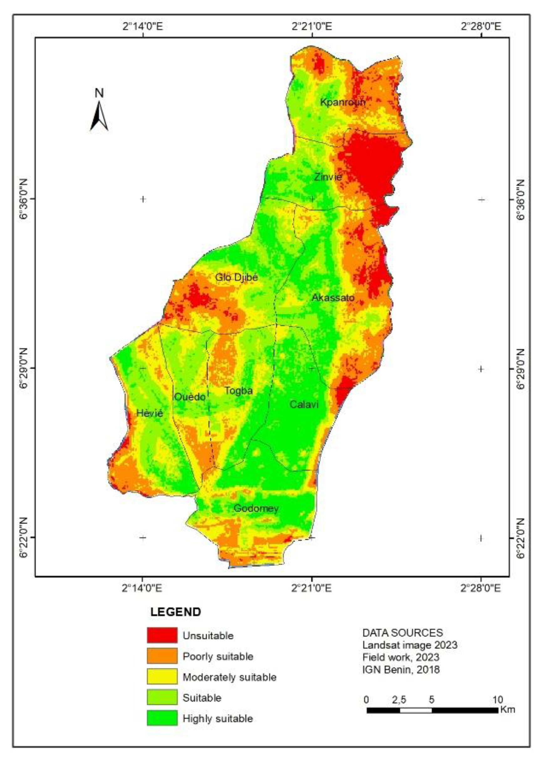
Overall, the city of Abomey-Calavi is well suited to the installation of public green spaces. According to the criteria defined, 23.27% of the surface area of this municipality is very suitable and located in densely populated areas at medium altitudes. The next most suitable areas cover 26.06% of the area. The majority of these areas are located in the centre and are distributed in a linear fashion from the south to the north-west and then to the west of the municipality. Unsuitable areas account for 21.92% of the land area, most of which is located on the slopes and depressions. Apart from these exploitable sites, the rest of the area, i.e. 21.11% of the commune, is only slightly suitable and 7.62% is unsuitable.
Figure 8.
Suitable areas map for urban green spaces in Abomey-Calavi district.
Discussion
Using Geographic Information System (GIS) and a multi-criteria hierarchical approach, this study identified the main factors for drawing up a suitability map for the installation of green spaces in the municipality of Abomey-Calavi, a town that has already been almost entirely developed. The method is based on the superposition by summation of spatial layers according to their weights [26]. The weight of each factor is determined by a binary comparison of the criteria for prioritising the factors on the basis of a prioritisation scale [41]. It has been used successfully in various fields [17,44], and more specifically in the field of green space management [21]. Indeed, it takes into account the weight of each factor on the judgements of actors or stakeholders, evaluating and minimising the inconsistencies linked to their choice [45]. In the context of this study, the approach made it possible to minimise the subjectivity of the weighting of factors [46] and to realise the need to take them into account as a stakeholder requirement for the use of green spaces. This confirms the recommendations of [24] on the importance of seeking consistency in the criteria for selecting sites for green spaces. From the point of view of implications, the method used, although hybrid [18], has both a robustness and a flexibility [47] that allow it to be tested in another socio-environmental context and on larger territories to objectively identify suitable spaces for the implementation of urbanisation, tourism and sustainable development projects.
In terms of results, the suitability map obtained indicates that the sites suitable for the installation of green spaces are located on inhabited land and at altitude, covering approximately 49.33% of the surface area of the municipality. This demonstrates the strength of the approach used to identify suitable sites for the sustainable installation of green spaces [24]. However, for good decision-making, other development parameters such as the allotment plan and the availability of land and administrative reserves must be taken into account [48], which could help refine site choices. Although large areas have been shown to be suitable for the installation of sustainable green spaces, very few green spaces exist in this commune. This is indicative of the low priority given to green infrastructure by decision-makers [11]. Given that green infrastructure has been recognised as an essential component in the well-being of city dwellers [10], it would be important to take account of the results of this study in the city's spatial planning. However, it is necessary to fall back on spaces available in the public domain in order to limit the relocation of populations. Similar to our GIS-based approach, [49] identified green spaces in the city of Cukurova in Turkey that facilitate recreation, picnics and rest areas for the populations of the city and the surrounding area. In the same country, and more specifically in the town of Kutahya, [16] used GIS analysis, while [27] looked at the town of Pendik, using the same methodological approach to identify areas suitable for the creation of green spaces accessible to citizens. These various examples demonstrate the importance of considering cities separately within the same nation when identifying areas suitable for the establishment of green spaces.
The current distribution of sites suitable for green spaces has been guided by the weight given to each factor. Thus, the eigenvectors resulting from the binary comparison of the weights of the priority factors in the analysis are 18%, while the other factors have a weight of 14%. This means that some factors are more important than others according to the stakeholders [50]. However, the implementation of any management plan based on these results must take account of inhabited areas to avoid affecting people, but also and above all the choice of species with carbon sequestration potential such as Terminalia superba (Combretaceae), which creates quite remarkable shade through its tiered crown and is used in many other African countries for this purpose (https://uses.plantnet-project.org/e/index.php?title=Terminalia_superba_(PROTA)&mobileaction=toggle_view_desktop). Many other criteria relating to the choice of species should be taken into consideration.
Conclusions
This study used GIS and the AHP approach to determine the spatial distribution of sites conducive to the installation of green spaces in the municipality of Abomey Calavi. The results obtained indicate that there is a strong dependence between the sites suitable for the installation of sustainable green spaces and environmental factors. The combination of these factors made it possible to identify large areas of land (around 49.33%) that are very suitable or suitable for landscaping in this city. Some of these factors, such as altitude, proximity to road networks and larges conurbations, and distance from wetlands, appear to be priorities in terms of the study area. These results highlight the importance of the role of spatial components and socio-cultural considerations in the development of sustainable urban systems. In addition, the study revealed how the combination of two approaches can contribute to making coherent choices for sound territorial and municipal decisions. In view of Benin's land policy, which focuses on the subdivision of various communes and sustainable tourism development, and with a view to greening large-scale areas, a hierarchy of factors based on the typology of green spaces can be envisaged in the identification of suitable sites. The authors hope that these results will be of use not only to Abomey-Calavi town council but also to the Ministry of Decentralisation of the Republic of Benin in general, in order to provide better guidance to the various towns on the importance of conducting such studies for sustainable green development. The ecological monitoring and conservation of green spaces after their installation are required to achieve such a sustainability.
Author Contributions
Conceptualization, data collection, data analysis, article writing and its correction, A.A.O. ; H.O.D.Y. and G.H.F.G.; Supervision, editing and validation before submission, B.S.
Funding
No funding was received in the framework of this research.
Data Availability Statement
Data supporting the writing of this article are shown throughout tables and figures and are also available with authors.
Acknowledgments
Authors are grateful to informants who took part in this research project. They are also thankful to reviewers whose comments helped improved this paper.
Conflicts of Interest
Authors declare no conflict of interest dealing with this research article.
References
- Calaza, P.; Cariñanos, P.; Escobedo, F.J.; Schwab, J.; Tovar, G. Bâtir une infrastructure verte et des paysages urbains.; FAO: Unasylva, 2018; Vol. 69 :;
- Girma, Y.; Terefe, H.; Pauleit, S.; Kindu, M. Urban green infrastructure planning in Ethiopia: The case of emerging towns of Oromia special zone surrounding Finfinne. J. Urban Manag. 2019, 8, 75–88. [CrossRef]
- Barthel, S.; Folke, C.; Colding, J. Social–ecological memory in urban gardens—Retaining the capacity for management of ecosystem services. Glob. Environ. Change 2010, 20, 255–265. [CrossRef]
- Kouadio, Y.J.C.; Vroh, B.T.A.; Bi, Z.B.G.; Yao, C.Y.A.; N’guessan, K.E. Évaluation de la diversité et estimation de la biomasse des arbres d’alignement des communes du Plateau et de Cocody (Abidjan - Côte d’Ivoire). J. Appl. Biosci. 2016, 97, 9141–9151. [CrossRef]
- Kenney, W.A.; Wassenaer, P.J.E. van; Satel, A.L. Criteria and Indicators for Strategic Urban Forest Planning and Management. Arboric. Urban For. AUF 2011, 37, 108–117. [CrossRef]
- Fuwape, J.A.; Onyekwelu, J.C. Urban Forest Development in West Africa: Benefits and Challenges. J. Biodivers. Ecol. Sci. 2011, 1, 77.
- Livesley, S.J.; McPherson, G.M.; Calfapietra, C. The Urban Forest and Ecosystem Services: Impacts on Urban Water, Heat, and Pollution Cycles at the Tree, Street, and City Scale. J. Environ. Qual. 2016, 45, 119–124. [CrossRef]
- Salbitano, F.; Borelli, S.; Conigliaro, M.; Chen, Y. Directives sur la foresterie urbaine et périurbaine; Étude FAO: Forêts; FAO: Rome, 2017; ISBN 978-92-5-130074-9.
- Cilliers, S.; Cilliers, J.; Lubbe, R.; Siebert, S. Ecosystem services of urban green spaces in African countries—perspectives and challenges. Urban Ecosyst. 2013, 16, 681–702. [CrossRef]
- Mili, M.; Boutabba, H.; Boutabba, S.-D. La nature urbaine: dégradation quantitative et qualitative des espaces verts urbains, cas de la ville steppique de M’Sila, Algérie. Urbe Rev. Bras. Gest. Urbana 2019. [CrossRef]
- Sehoun, L.C.; Osseni, A.A.; Orounladji, M.; Lougbegnon, T.O.; Codjia, J.C.T. Diversité floristique des formations végétales urbaines au Sud du Bénin (Afrique de l’Ouest). Rev. Marocaine Sci. Agron. Vét. 2021, 9.
- Dossou, O.V. Contribution de l’évaluation environnementale stratégique a l’aménagement du territoire : cas du plan directeur d’aménagement du plateau d’abomey-calavi (république du bénin). Thèse de Doctorat Unique, Université d’Abomey-Calavi: Abomey-Calavi, 2005.
- INSAE Effectifs de la population des villages et quartiers de ville du Bénin (RGPH-4, 2013).; Institut national de la statistique et de l’analyse economique (INSAE), 2016;
- Dossou-Yovo, H.O.; Vodouhè, F.G.; Kaplan, A.; Sinsin, B. Application of Ethnobotanical Indices in the Utilization of Five Medicinal Herbaceous Plant Species in Benin, West Africa. Diversity 2022, 14, 612. [CrossRef]
- Amontcha, A.M.; Djego, J.G.; Imorou, I.T.; Sinsin, B.A. Phyto-diversite et utilisations des espaces verts prives dans les villes du grand Nokoue (Sud-Benin). J. Rech. Sci. L’Université Lomé 2017, 19, 117–139. [CrossRef]
- Cetin, M. Using GIS analysis to assess urban green space in terms of accessibility: case study in Kutahya. Int. J. Sustain. Dev. World Ecol. 2015, 22, 420–424. [CrossRef]
- Olayiwola, A.; Suleiman, U. Site Suitability Analysis for Landfill in an Industrial Area in Nigeria. J. Environ. Geogr. 2022, 15, 1–10. [CrossRef]
- Ozsahin, E.; Ozdes, M.; Smith, A.C.; Yang, D. Remote Sensing and GIS-Based Suitability Mapping of Termite Habitat in the African Savanna: A Case Study of the Lowveld in Kruger National Park. Land 2022, 11, 803. [CrossRef]
- Abebe, W.T.; Endalie, D. Artificial intelligence models for prediction of monthly rainfall without climatic data for meteorological stations in Ethiopia. J. Big Data 2023, 10, 1–15. [CrossRef]
- Cakir, S.; Hecht, R.; Krellenberg, K. Sensitivity analysis in multi-criteria evaluation of the suitability of urban green spaces for recreational activities. AGILE GIScience Ser. 2021, 2, 1–8. [CrossRef]
- Linh, N.H.K.; Tung, P.G.; Chuong, H.V.; Ngoc, N.B.; Phuong, T.T. The Application of Geographical Information Systems and the Analytic Hierarchy Process in Selecting Sustainable Areas for Urban Green Spaces: A Case Study in Hue City, Vietnam. Climate 2022, 10, 82. [CrossRef]
- Lotfata, A. Using Remote Sensing in Monitoring the Urban Green Spaces: A Case Study in Qorveh, Iran. Eur. J. Environ. Earth Sci. 2021, 2, 11–15. [CrossRef]
- PDC-Abomey-Calavi Mairie d’Abomey-Calavi. Plan de Développement Communal troisième génération de la Commune d’Abomey-Calavi PDC3 2018-2022, Consultant : Groupement ECOPLAN/Triomphe Afrique Group; 2017;
- Gelan, E. GIS-based multi-criteria analysis for sustainable urban green spaces planning in emerging towns of Ethiopia: the case of Sululta town. Environ. Syst. Res. 2021, 10, 13. [CrossRef]
- Stalmeijer, R.E.; Mcnaughton, N.; Van Mook, W.N.K.A. Using focus groups in medical education research: AMEE Guide No. 91. Med. Teach. 2014, 36, 923–939. [CrossRef]
- Kacem, L.; Agoussine, M.; Igmoullan, M.; Amar, H.; Mockhtari, S.; Ait Brahim, Y. Application de la méthode d’analyse multicritère hiérarchique pour la quantification de perte en sol dans un sous-bassin montagnard -haute vallée de Tifnoute (Haut Atlas marocain). ., 41, 3, n.s. : 493-502. Geo-Eco-Trop 2017, 41, 493–502.
- Ustaoglu, E.; Aydınoglu, A.C. Site suitability analysis for green space development of Pendik district (Turkey). Urban For. Urban Green. 2020, 47, 126542. [CrossRef]
- Nguyen, T.T.M.; Nguyen, H.T.T.; Doan, T.; Tri, D.Q. Application Analytic Hierarchical Process (AHP) in Setting up Local Community Urban Environmental Quality of Life Index in a Developed Metropolitan Area in Ho Chi Minh City, Vietnam. Curr. Urban Stud. 2021, 9, 376–391. [CrossRef]
- Dağıstanlı, C.; Turan, İ.D.; Dengiz, O. Evaluation of the suitability of sites for outdoor recreation using a multi-criteria assessment model. Arab. J. Geosci. 2018, 11, 492. [CrossRef]
- Li, Z.; Fan, Z.; Shen, S. Urban Green Space Suitability Evaluation Based on the AHP-CV Combined Weight Method: A Case Study of Fuping County, China. Sustainability 2018, 10, 2656. [CrossRef]
- Piran, H.; Maleknia, R.; Akbari, H.; Soosani, J.; Karami, O. Site selection for local forest park using analytic hierarchy process and geographic information system ( case study : Badreh County ).; 2013.
- Mahdavi, A.; Niknejad, M. Site suitability evaluation for ecotourism using MCDM methods and GIS: case study - Lorestan province, Iran. J. Biodivers. Environ. Sci. JBES 2014, 4, 425–437.
- Shahabi, H.; Hashim, M. Landslide susceptibility mapping using GIS-based statistical models and Remote sensing data in tropical environment. Sci. Rep. 2015, 5, 9899. [CrossRef]
- Mahmoud, A.H.A.; El-Sayed, M.A. Development of sustainable urban green areas in Egyptian new cities: The case of El-Sadat City. Landsc. Urban Plan. 2011, 101, 157–170. [CrossRef]
- Bunruamkaew, K.; Murayam, Y. Site Suitability Evaluation for Ecotourism Using GIS & AHP: A Case Study of Surat Thani Province, Thailand. Procedia - Soc. Behav. Sci. 2011, 21, 269–278. [CrossRef]
- Kienast, F.; Degenhardt, B.; Weilenmann, B.; Wäger, Y.; Buchecker, M. GIS-assisted mapping of landscape suitability for nearby recreation. Landsc. Urban Plan. 2012, 105, 385–399. [CrossRef]
- Morckel, V. Using suitability analysis to select and prioritize naturalization efforts in legacy cities: an example from Flint, Michigan. Urban For. Amp Urban Green. 2017, 27, 343–351. [CrossRef]
- Peng, J.; Ma, J.; Du, Y.; Zhang, L.; Hu, X. Ecological suitability evaluation for mountainous area development based on conceptual model of landscape structure, function, and dynamics. Ecol. Indic. 2016, 61, 500–511. [CrossRef]
- Jahn, R.; Blume, H.P.; Asio, V.; Spaargaren, O.; Schád, P. FAO Guidelines for Soil Description; 2006;
- Adimi, O.S.C.; Oloukoi, J.; Tohozin, C.A.B. Analyse spatiale multicritère et identification des sols propices à la production du maïs à Ouessè au Bénin. VertigO - Rev. Électronique En Sci. Environ. 2018. [CrossRef]
- Saaty, T.L. Decision making with the analytic hierarchy process. Int. J. Serv. Sci. 2008, 1, 83–98. [CrossRef]
- Saaty, T.L. A scaling method for priorities in hierarchical structures. J. Math. Psychol. 1977, 15, 234–281. [CrossRef]
- Malczewski, J.; Rinner, C. Exploring multicriteria decision strategies in GIS with linguistic quantifiers: A case study of residential quality evaluation. J. Geogr. Syst. 2005, 7, 249–268. [CrossRef]
- Ramos, A.; Cunha, L.; Cunha, P. Application de la Méthode de l’Analyse Multicritère Hiérarchique à l’étude des glissements de terrain dans la région littorale du centre du Portugal : Figueira da Foz – Nazaré. Geo-Eco-Trop 2014, 38, 33–44.
- El Jazouli, A.; Barakat, A.; Khellouk, R. GIS-multicriteria evaluation using AHP for landslide susceptibility mapping in Oum Er Rbia high basin (Morocco). Geoenvironmental Disasters 2019, 6, 3. [CrossRef]
- Zhou, S.; Chen, G.; Fang, L.; Nie, Y. GIS-Based Integration of Subjective and Objective Weighting Methods for Regional Landslides Susceptibility Mapping. Sustainability 2016, 8, 334. [CrossRef]
- Yan, F.; Zhang, Q.; Ye, S.; Ren, B. A novel hybrid approach for landslide susceptibility mapping integrating analytical hierarchy process and normalized frequency ratio methods with the cloud model. Geomorphology 2019, 327, 170–187. [CrossRef]
- Zannou, S.; Fangnon, B.; Doussou-Guedegbe, O. Urbanisation et problématique de gestion de l’espace dans l’arrondissement de Dangbo au Bénin. In Mélange en l’hommage au Professeur Emérite N’BESSA D. Bénoît; 2018; pp. 7–23 ISBN 978-99919-79-99-1.
- Adigüzel, F.; Doğan, M. Analysis of Sufficiency and Accessibility of Active Green Areas in Cukurova. Kastamonu Univ. J. Eng. Sci. 2020, 6, 95–106.
- Toro, J.; Duarte, O.; Requena, I.; Zamorano, M. Determining Vulnerability Importance in Environmental Impact Assessment: The case of Colombia. Environ. Impact Assess. Rev. 2012, 32, 107–117. [CrossRef]
Figure 1.
Location of Benin in West Africa and Abomey-Calavi district in Benin.
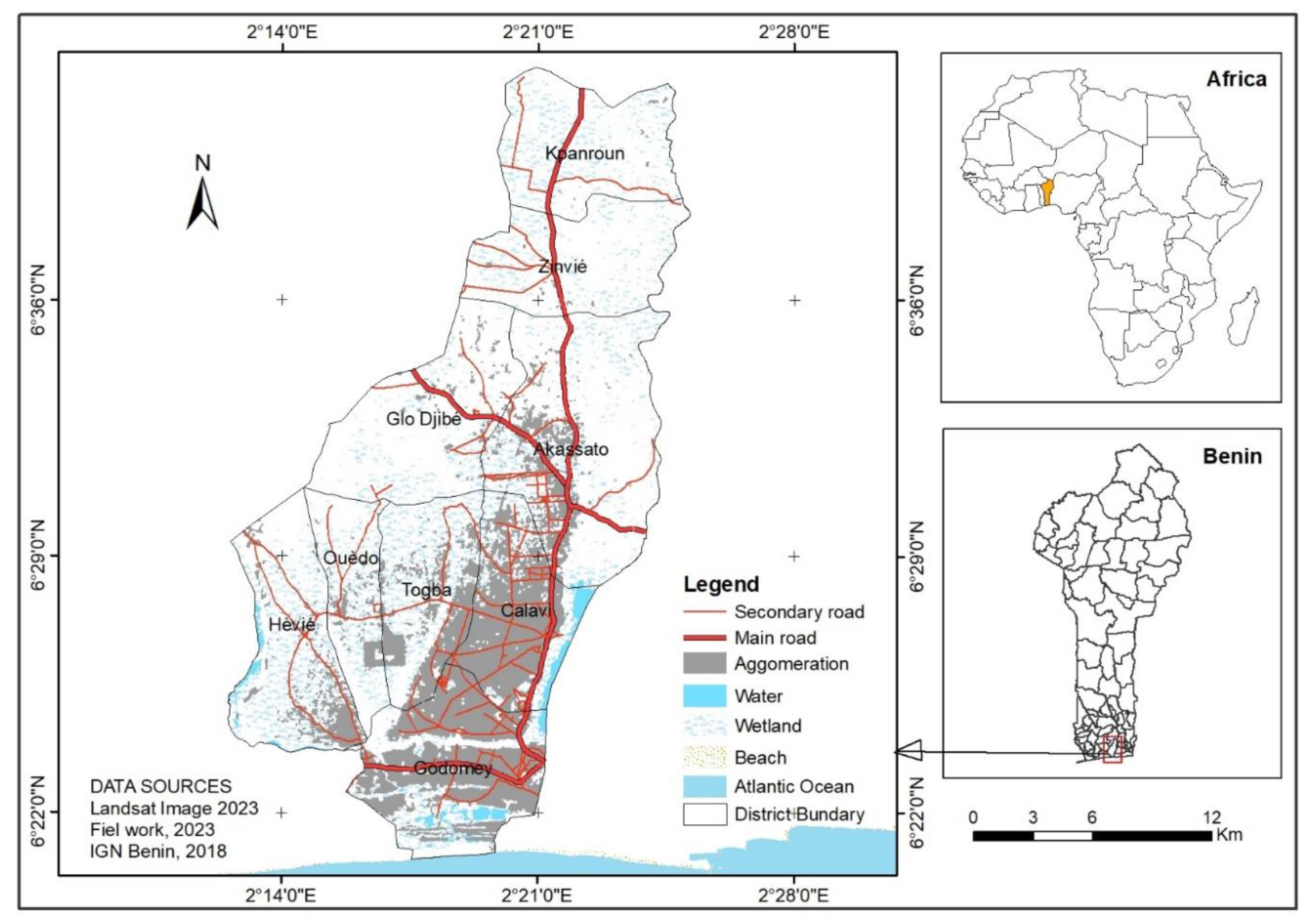
Figure 2.
Land use map (a) and it reclassification (b).
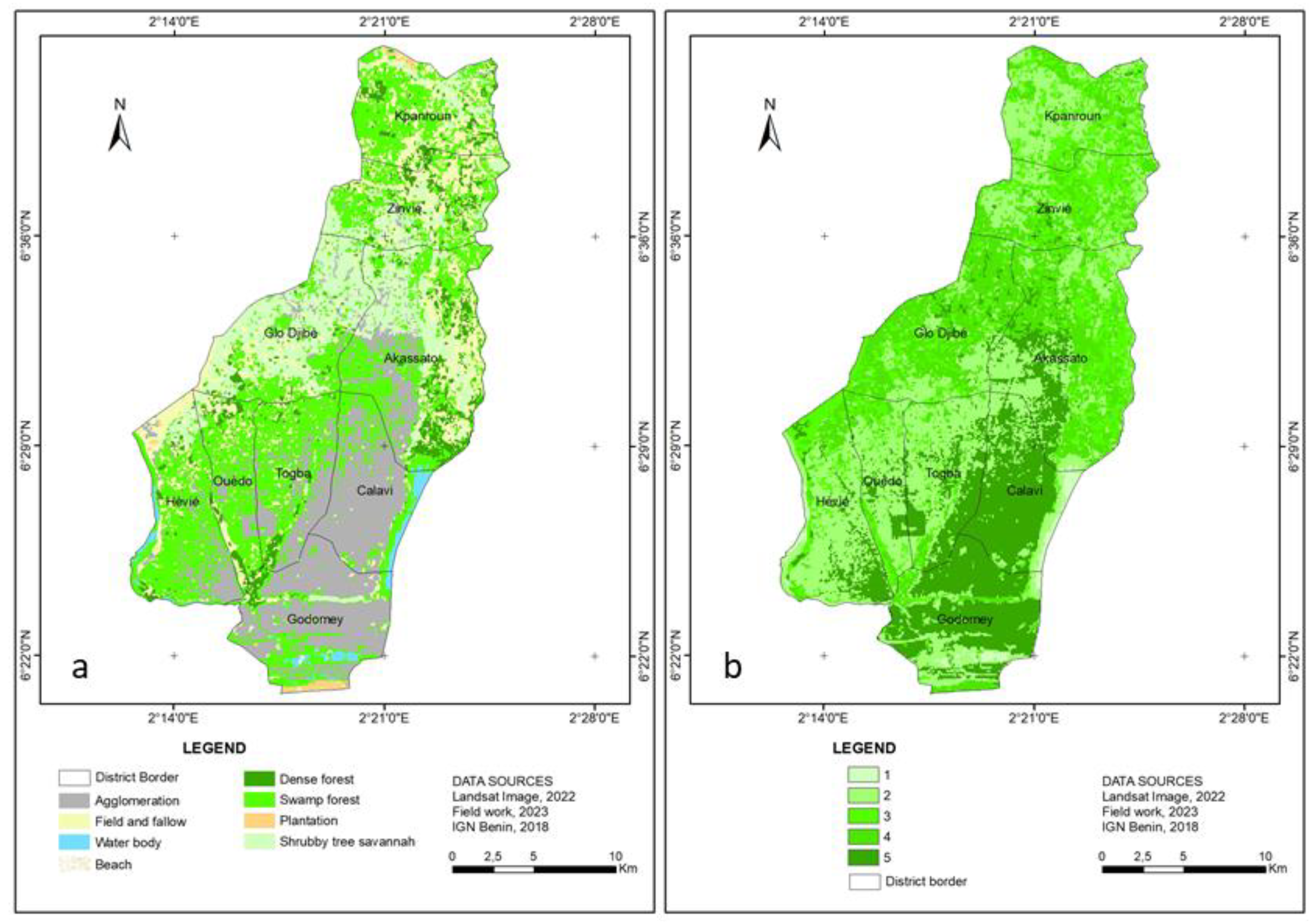
Figure 3.
Elevation map (a) and it reclassification (b).
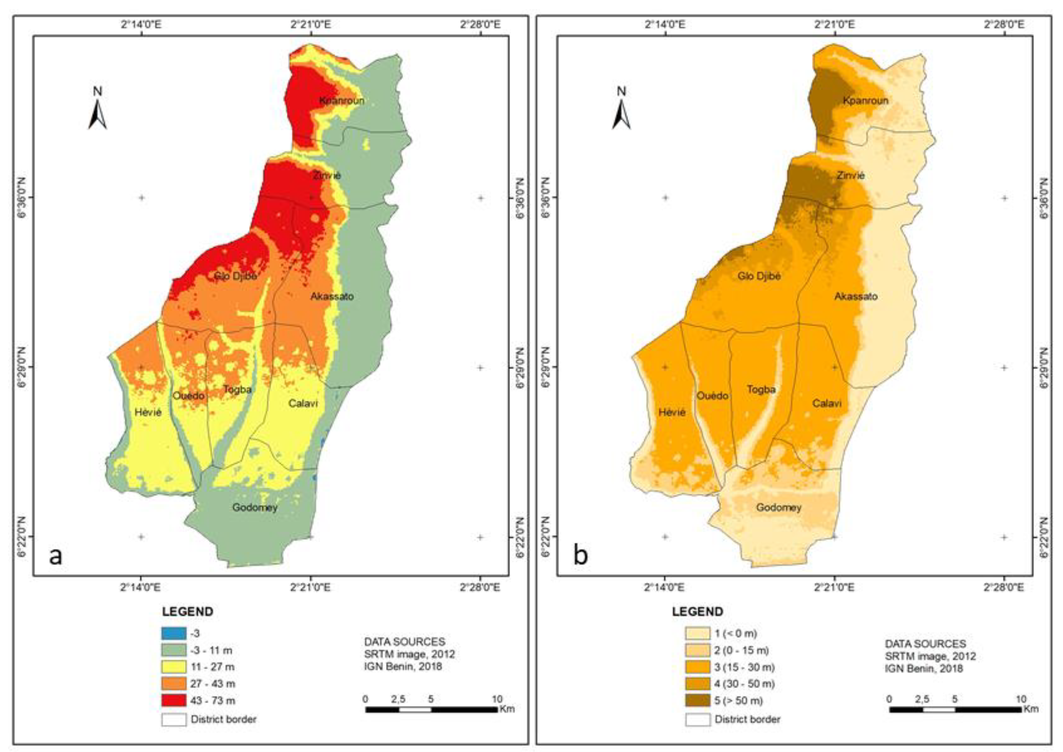
Figure 4.
Slope map (a) and it reclassification (b).
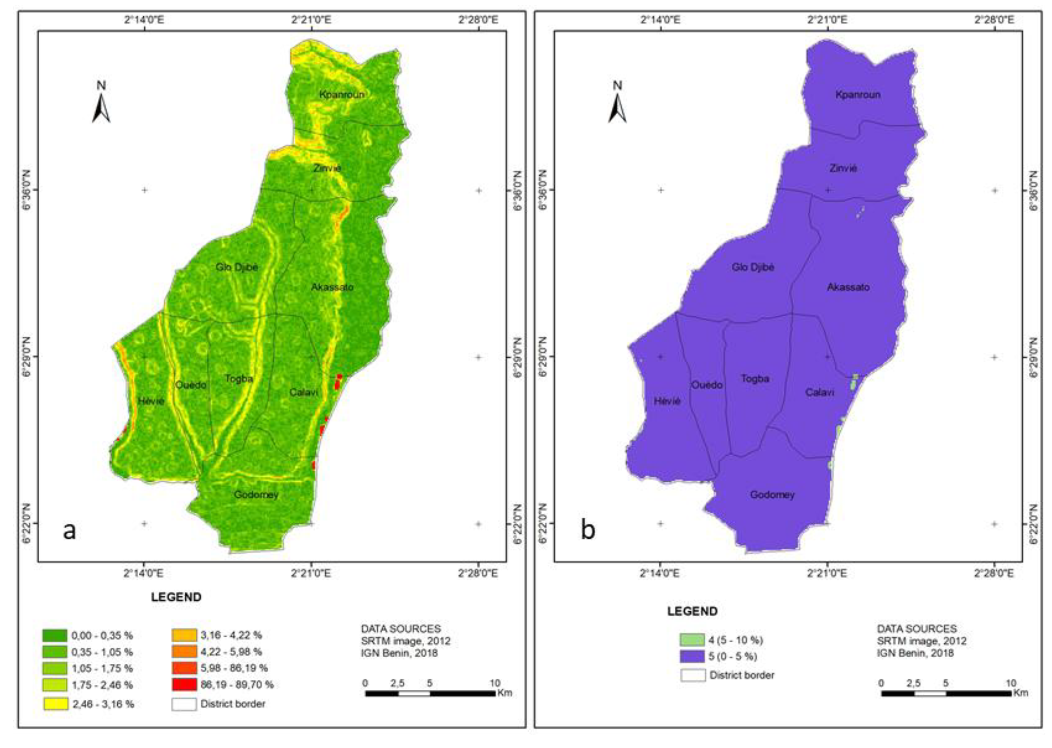
Figure 5.
Flood-prone map (a) and it reclassification (b).
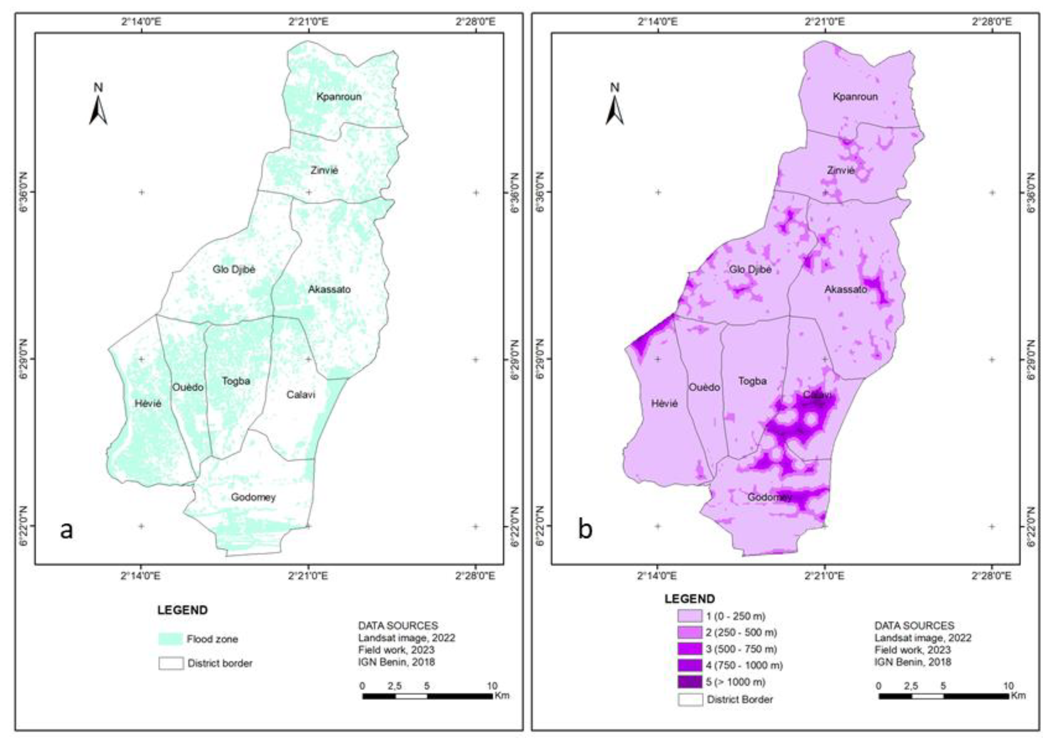
Figure 6.
Road map (a) and it reclassification (b).
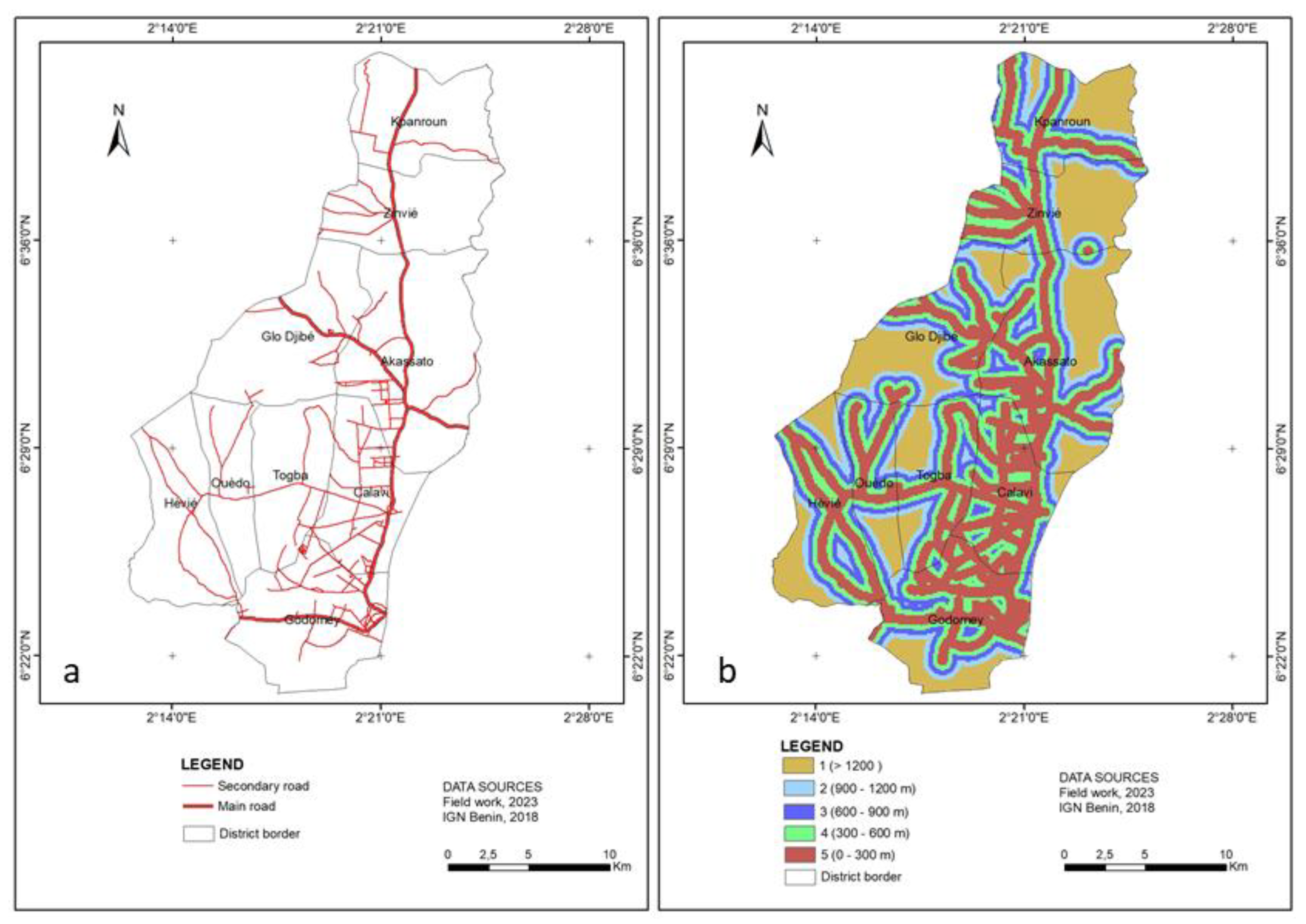
Figure 7.
Built-up map (a) and it reclassification (b).
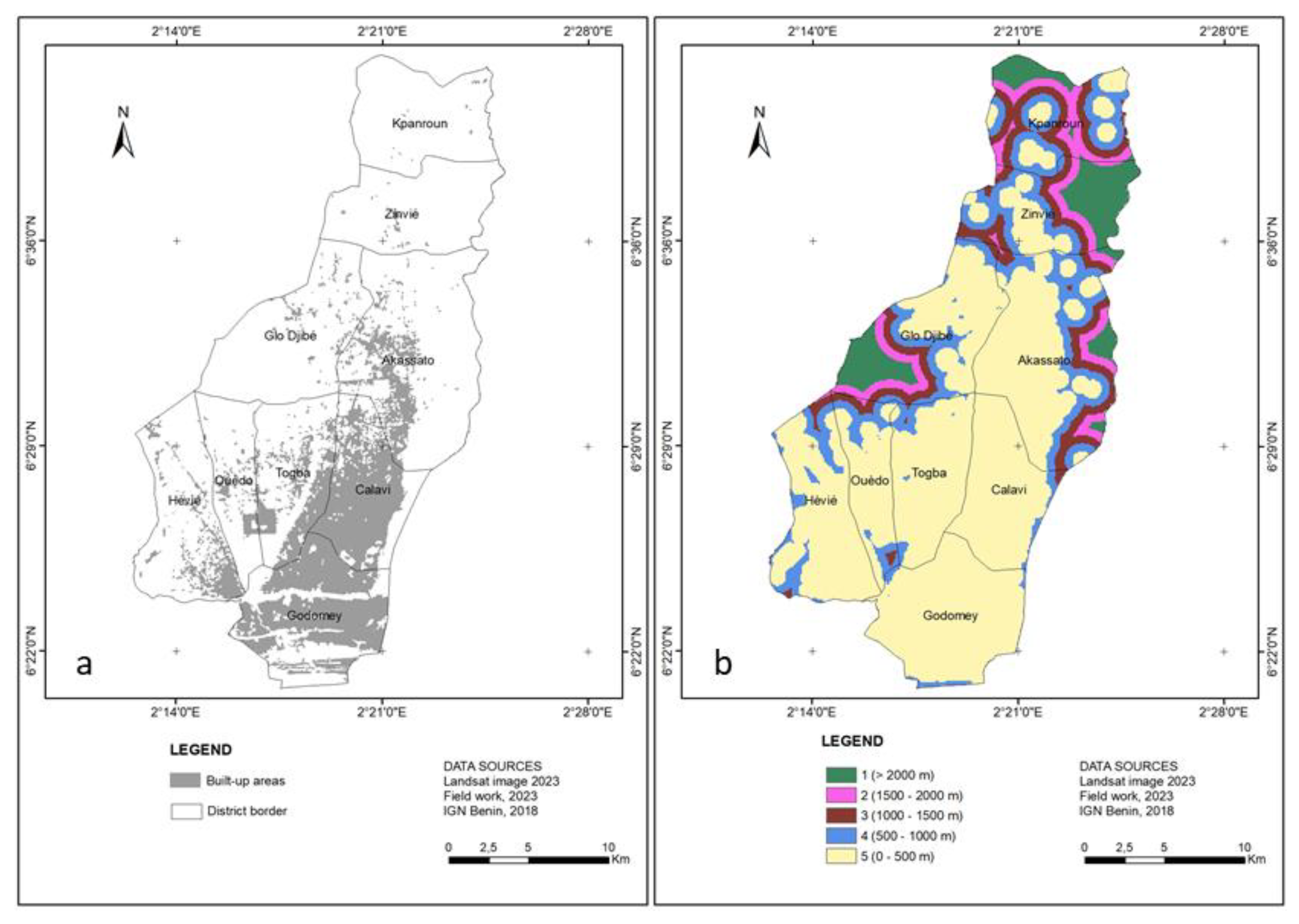

Table 1.
Types of data, sources and usefulness for identifying suitable sites.
| Type of Data | Sources | Utility |
|---|---|---|
| Landsat Image OLI, 2023 | United States Geological Studies (USGS) https://earthexplorer.usgs.gov/ |
Land cover/ Land use, Distance from flood-prone, Proximity to roads and built-up |
| Digital Elevation Model SRTM : Shutle Radar Topography Mission, 2000 | USGS : https://earthexplorer.usgs.gov/ | Elevation and slope |
| Roads network | Topographic Map, Benin Survey (IGN Bénin), 2018 | Distance to main roads |
| Population and experts opinions | Field work (Focus group), Avril 2023 | Identification of local populations’ expectations of green spaces and ranking of important criteria |
| Technical and scientific reports | Appropriate websites | Literature review on indicators and experts opinions according to suitable areas of green spaces |
Source : Data collection work, 2023.
Table 2.
Prioritisation of analysis criteria for suitable green space factors in Abomey-Calavi district.
Table 2.
Prioritisation of analysis criteria for suitable green space factors in Abomey-Calavi district.
| Factors | Description of Criteria | Prioritisation | Assessment |
|---|---|---|---|
| Land use | Agglomeration | 5 | Highly suitable |
| Vegetation | 4 | Suitable | |
| Field and fallow | 3 | Moderately suitable | |
| Flood-prone area | 2 | Poorly suitable | |
| Water body | 1 | Unsuitable | |
| Elevation | < 0 m | 1 | Unsuitable |
| 0 - 15 m | 2 | Poorly suitable | |
| 15 - 30 m | 3 | Moderately suitable | |
| 30 - 50 m | 4 | Suitable | |
| > 50 m | 5 | Highly suitable | |
| Slope | 0 - 5 % | 5 | Highly suitable |
| 5 - 10 % | 4 | Suitable | |
| 10 - 15 % | 3 | Moderately suitable | |
| 15 - 20 % | 2 | Poorly suitable | |
| > 20 % | 1 | Unsuitable | |
| Distance from flood-prone | 0 - 250 m | 1 | Unsuitable |
| 250 - 500 m | 2 | Poorly suitable | |
| 500 - 750 m | 3 | Moderately suitable | |
| 750 - 1000 m | 4 | Suitable | |
| > 1000 m | 5 | Highly suitable | |
| Proximity to roads | 0 - 300 m | 5 | Highly suitable |
| 300 - 600 m | 4 | Suitable | |
| 600 - 900 m | 3 | Moderately suitable | |
| 900 - 1200 m | 2 | Poorly suitable | |
| > 1200 | 1 | Unsuitable | |
| Proximity to built-up | 0 - 500 m | 5 | Highly suitable |
| 500 - 1000 m | 4 | Suitable | |
| 1000 - 1500 m | 3 | Moderately suitable | |
| 1500 - 2000 m | 2 | Poorly suitable | |
| > 2000 m | 1 | Unsuitable |
Source : Field work, 2023.
Table 3.
Binary comparison and eigenvectors of the factors used to analyse the identification of sites suitable for green spaces in the municipality of Abomey-Calavi.
Table 3.
Binary comparison and eigenvectors of the factors used to analyse the identification of sites suitable for green spaces in the municipality of Abomey-Calavi.
| Criterion | Land Use | Elevation | Slope | Distance from Flood-Prone | Proximity to Roads | Proximity to Built-Up |
|---|---|---|---|---|---|---|
| Land use | 0.14 | 0.14 | 0.14 | 0.14 | 0.14 | 0.14 |
| Elevation | 0.18 | 0.18 | 0.18 | 0.18 | 0.18 | 0.18 |
| Slope | 0.14 | 0.14 | 0.14 | 0.14 | 0.14 | 0.14 |
| Distance from flood-prone | 0.18 | 0.18 | 0.18 | 0,18 | 0,18 | 0.18 |
| Proximity to roads | 0.18 | 0.18 | 0.18 | 0.18 | 0.18 | 0.18 |
| Proximity to built-up | 0.18 | 0.18 | 0.18 | 0.18 | 0.18 | 0.18 |
| Eigenvectors (%) | 14 % | 18 % | 14 % | 18 % | 18 % | 18 % |
Source : Field works, 2023.
Disclaimer/Publisher’s Note: The statements, opinions and data contained in all publications are solely those of the individual author(s) and contributor(s) and not of MDPI and/or the editor(s). MDPI and/or the editor(s) disclaim responsibility for any injury to people or property resulting from any ideas, methods, instructions or products referred to in the content. |
© 2023 by the authors. Licensee MDPI, Basel, Switzerland. This article is an open access article distributed under the terms and conditions of the Creative Commons Attribution (CC BY) license (http://creativecommons.org/licenses/by/4.0/).
Copyright: This open access article is published under a Creative Commons CC BY 4.0 license, which permit the free download, distribution, and reuse, provided that the author and preprint are cited in any reuse.


