
Submitted:
05 November 2024
Posted:
05 November 2024
You are already at the latest version
Abstract
Accurate information on ecotourism site suitability is crucial for effective planning, aiding in ecological conservation and local economic uplift. This study addresses the lack of documented ecotourism site suitability in the Lake Tana watershed of Ethiopia by evaluating factors such as elevation, slope, vegetation density, and proximity to water and infrastructure using Geographical Information System (GIS) and multi-criteria evaluation methods. The Analytical Hierarchy Process (AHP) combined with GIS was used to create a resource inventory and establish sustainable tourism criteria. A suitability map was developed based on weights from pair-wise comparisons of the selected criteria. Results show that 20% of the area, particularly near Lake Tana and water bodies, is highly suitable for ecotourism. Additionally, 50% is moderately suitable, 3.1% is marginally suitable, and 26% is unsuitable for development. These findings can guide resilient policies for ecotourism initiatives and help assess sustainable tourism in other regions. Regional tourism offices, Non-governmental Organizations, and policymakers can use this data to evaluate natural resource suitability for ecotourism, providing a foundation for further research in the field.
Keywords:
Ecotourism initiatives
; ecotourism state suitability
; establish sustainable tourism criteria
; evaluate natural resource availability
; guide resilient policies
; sustainable tourism
1. Introduction
Ecotourism, often referred to as “ecological tourism” is a multidimensional economic activity that is centered on the conservation of natural and cultural resources ( Stronza et al., 2019; Beall et al., 2021; Angessa, 2022). The primary goal of ecotourism is to promote economic and social development without compromising the state of biodiversity and natural ecosystem. As Santarém et al. (2020) stated ecotourism has the potential to be an economically, socially, and environmentally sound strategy for promoting sustainable development.
Over the past 20 years, the global ecotourism industry has experienced rapid growth (Kiper, 2013; Aryal et al., 2019; Cavalcante et al., 2021). However, the development of ecotourism also faces environmental, economic and social challenges (Xu et al., 2022). These challenges are urgent problems to be solved through the sustainable development of ecotourism (Mallick et al., 2020). The rapid rise in tourism and the increasing number of visitors are endangering wildlife and the preservation of endangered ecosystems (Goodwin, 1996; Fletcher, 2019). In line with this, Buckley (2009) reported that rapid and uncontrolled ecotourism development in sensitive natural areas can have a significant detrimental effect on the environment.
Ethiopia is home to abundant natural, historical, and archaeological resources that are ideal for the growth of sustainable ecotourism ventures (Zegeye, 2016; Tesfaye, 2017). The country is blessed with natural tourist sites like mountains, valleys, rivers, lakes, deep gorges. However, in terms of tourism revenue, Ethiopia is among the lowest sub-Saharan Africa (Nigatu, 2016; Estifanos et al., 2021). The main challenges facing the ecotourism sector in Ethiopia include a lack of tourism infrastructure, financial support, and effective promotions.
The Lake Tana watershed in Ethiopia is endowed with various potential resources for ecotourism development. Based on filed observation and key informant interviews, the watershed is blessed with natural wonders such as Lake Tana basin, ancient monasteries, rivers, mountains, valleys, and a wealth of unique flora and fauna. Despite the basin’s high potential for ecotourism, these resources have not been well-explored or developed to their full potential. The main obstacles hindering the fulfilment of the basin’s ecotourism potential are the lack of tourism planning and suitability analysis. It is crucial to identify areas with characteristics that appeal to tourists. However, the selection of ecotourism sites is controlled by various factors including socio cultural, environmental, physical, and socioeconomic considerations, which vary from place to place (Işik & Demir, 2017; Deribew et al., 2022). In ecotourism site selection, natural resources are more preferred than cultural resources (Taye et al., 2019; Angessa et al., 2022). Factors such as land scape condition, accessibility, and topography area the main considerations affecting ecotourism site development.
Recently, researchers have attempted to assesses the potential for ecotourism site suitability in different parts of Ethiopia using Geospatial and qualitative approaches (Nigatu, 2016; Tesema & Berhan, 2019; Taye et al., 2019; Ambecha et al., 2020). As Guan et al. (2011) stated accurate information on ecotourism site suitability is crucial for ecotourism planning, as it supports through the conservation and preservation of the area’s ecological diversity, as well as the economic development of local communities However, there is a lack of well-documented information on ecotourism site suitability in Lack Tana watershed. This study aims to evaluate the suitability of ecotourism sites in the Lake Tana watershed using GIS and multi criteria evaluation methods. The findings of this study provide a significant opportunity to inform policy makers, planners, and practitioners on the novel application of GIS-based multi-criteria evaluation for ecotourism planning in the region.
2. Materials and Methods
2.1. Description of Study Area
The study was conducted in Lake Tana watershed from, which is located in north western Ethiopia. The total area of the watershed, including the lake water body, is around 11495.7 km2. Geographically, the study area extends from 11o 00’ to 12o45’ N latitude, and 36o 50’to 38o 20’ E longitude (Figure 1). The physiography of study area is characterized by diverse topographic conditions (valley, plains, undulating hills, and mountains) with the elevations ranges from 1,676 to 4,104 meter above sea level (m asl.). The watershed has an average air temperature and annual precipitation of 20oC and1280 mm, respectively.
The watershed has four major tributaries s: Gilgel Abay, Gumara, Rib and Megech. Blue Nile (also named as River Abbay) is the river that flows 35 km from Lake Tana a before it forms a wonderful tourist attraction site known as Tis Issat Falls. Lake Tana has a variety of ecosystems, and ancient monasteries that had been built in the 14 century. The watershed is known to hold 437 bird species Aynalem (2017), and a total of 37 islands. In the basin many kinds of ecosystems including wetlands, afro-alpine, evergreen montane forests, scrubs and grasslands together with altitude range makes the area rich in biodiversity and attractive places (Worku, 2017; Woldu, 2018).
The study area within the Lake Tana watershed in Ethiopia can be classified into three distinct agro-climatic zones based on the traditional climate classification system, which is primarily based on altitude: alpine (3300-4104 m asl), temperate (2300-3300 m asl) and sub-tropical (1676-2300 m asl) (Figure1). Most of the population inhabits in sub-tropical and temperate agro-climatic zones. Rain-fed agriculture is the main livelihood of the people and the dominant soil types are Alisols, Leptosols, Nitosoils, Vertisols and Cambisols.
2.2. Data Sources
Data on the ecotourism potential of the study area were collected from various sources between February 2021 and February 2022 (Table 1). Vegetation data were extracted from the Moderate Resolution Imaging Spectro-radiometer (MODIS) Terra satellite’s MOD13Q1 NDVI (Normalized Difference Vegetation Index) product, which has a spatial resolution of 250 meters. The NDVI data used were for the year 2022. Elevation and slope information were obtained from the Shuttle Radar Topography Mission (SRTM) digital elevation model (DEM) with a 30-meter spatial resolution. The spatial data, including information on roads, rivers, and towns, were retrieved from the Digital Maps and Geospatial Data repository hosted by Princeton University (https://maps.princeton.edu/). These data layers were then analyzed using spatial data analysis tools to derive the distance from roads, rivers, and towns. All the geospatial data used in this analysis were obtained from reputable online data archives, such as the Earth Explorer portal (https://earthexplorer.usgs.gov/), which is maintained by the United States Geological Survey (USGS).
Key informant interviews and field observation were conducted to gather all relevant information available on the ground. Additionally, an intensive document review was carried out to diagnose any information gaps and complement the findings. All criteria were identified and selected based on expert opinion, field observation, and an intensive literature review.
2.3. Data Analysis and Processing
The methodology combines GIS techniques with the framework of Multi-criteria Decision-Making (MCDM) for suitability evaluation. Specifically, the Analytical Hierarchy Process (AHP) which, is an MCDM procedure, was utilized. AHP is an objective mathematical technique that considers human and mathematical choices by expressing the pairwise comparison between different parameters based on the proposed 1-9 scientific ratio (Saaty, 1990) (Table 2). AHP has a potential for solving conflicts and analyzing judgments through the process of determining the relative importance of identified criteria by pairwise comparison on a 9 point scale (Beynon, 2002; Albayrak & Erensal, 2004). The hierarchal structure is developed by applying a weight for each individual criterion in the entire decision process. The assigned value reflects the importance of each criterion by considering a pairwise comparison matrix of all identified criteria, by taking two criteria at a time (Mansour et al., 2020). To determine the relative importance of each criterion, expert opinion in the form of key informant interview, field observation and informal interview were conducted to compare the criteria on pairwise basis. The matrix format in pairwise comparisons is expressed as which is written as (Equetion1).
The overall matrix has the properties of reciprocity and is expressed as mathematically (Equation2)
Technically there are three steps followed while considering AHP decision making methods i.e. 1) Decomposition: - developing structural hierarchical process which includes goals and subordinate features. 2) Evaluation:- setting a pair wise comparative judgments between identified criteria at each level and 3) normalization:- it was performed in the pairwise comparison matrix and computed by dividing each criteria’s value from the column with the sum of the corresponding column and weight determination (Rohandi et al., 2018; Sahani, 2020; Chaudhary et al., 2022). AHP have an advantage for calculating the consistency ratio at each steps(equation 3 and 4), making this methods more robust than other multi-criteria decision-making (MCDM) techniques (Zandebasiri & Pourhashemi, 2016; Raha & Gayen, 2022).
where, ∂max is the principal eigenvalue and n is the number of factors depending on the order of the matrix. C.I denotes the degree of consistency or in consistency (Scholl et al., 2005; Mansour et al., 2020). If the consistency ratio is below 0.1 the pairwise consistency is fairly acceptable (Saaty, 1990). While if the consistency ration is more than 0.1 it is inconsistences in the evaluation and hence the original weights should be recalculated.
In our study the results of consistency ratio is 0.079 which are acceptable or consistent, and the estimated criteria weights are used for ecotourism site suitability evaluation (Table 2). Identified criteria were reclassified and their suitability was assigned in the standard format. The normal weight of each criterion was calculated based on assigned values when evaluating each parameter in matrix. Weighting overlay analysis was applied to produce a composite ecotourism suitability map. Accordingly the weight obtained after pairwise comparison and consistency ratio was assigned to each criterion, and the final overlay map with four suitability classes was generated. Figure 2 illustrates the general framework used to create a site suitability map for ecotourism development. All data preprocessing and preparation steps were performed using ArcGIS 10.4.
2.4. Validation Using ROC-AUC Method
In this study, the model’s performance was evaluated using the area under the receiver operating characteristic (ROC) curve (AUC) (Amare et al., 2021; Bradley, 1997)). AUC is a widely used metric for assessing classifier performance, as it remains unaffected by threshold settings. The ROC curve is generated by plotting the true positive rate (TPR) against the false positive rate at various thresholds (Amare et al., 2021; Bradley, 1997). To assess the suitability of ecotourism sites, ground truth points were collected using GPS and high-resolution images from Google Earth. The AUC value ranges from 0.5 to 1; a value near 1 indicates strong model performance, while a value close to 0.5 suggests poor performance. Generally, an AUC value greater than 0.7 is considered indicative of good accuracy (Amare et al., 2021; Bradley, 1997)Tsangaratos et al. 2017).
3. Results and Discussion
3.1. Selected Factors for Ecotourism Site Suitability Criteria
Ecotourism suitability has been evaluated by considering six potential factors: slope, elevation, proximity to rivers, proximity to roads, land use/land cover, and proximity to towns, along with information from local communities. Weights and scores were assigned to each criterion and attribute range based on the results of an expert questionnaire survey. These weights and scores determine the spatial distribution of suitability classes for each criterion and factor.
To generate the ecotourism suitability for each criterion, paired comparison matrices were utilized. The study also allows for further in-depth investigation into the ecotourism potential in areas with similar physical and socioeconomic characteristics. The findings indicate that vegetation cover (22%), elevation (21%), and proximity to towns, roads, and rivers are the most critical criteria with the greatest influence. Expert opinions and field observations confirm that the slope of the area has minimal impact on the suitability for developing ecotourism sites (Table 3). The computed consistency ratio is 0.079, which is less than 0.1, indicating that the weight values derived from the AHP pair-wise comparison matrix are reliable and acceptable for overlay analysis to produce meaningful results.
3.1.1. Proximity to Roads and Vegetation Densities
Accessibility of ecotourism site is highly affected by road networks. The types of road and its distance from preferred ecotourism site determine tourist destination and their brand. As Taye et al., (2019) stated good road network connectivity with proximity to scenic beauty like river and other natural resource provides fast and easy movement is high suitable.as confirmed from field observation and information from local communities tourists prefers to visit the area with good road networks and accessibility. In this study for the identification of ecotourism sites development four buffer zones from existing road network have been created. The analyses showed that the area within or less than two km buffer of the roads are ranked as high potential for ecotourism development; the areas within two to five km buffer zone of the roads were ranked as moderately suitable; the area within five to 10km and >10 km buffer from roads was ranked as marginally and not suitable for ecotourism development (Figure 3).
Vegetation density has a positive influence on ecotourism site suitability. Vegetation cover increases landscape attractiveness (Vannoppen et al., 2021). As Berta et al. (2022) stated forest and other vegetation species accelerate the value of ecotourism potentiality due to existent of wild life that attracts visitors. Forest and bush lands are highly important for ecotourism and environmental sustainability while bare land is less or not important for ecotourism development (Taye et al., 2019). The Zegie forest found in Zegie peninsula, Tana monasteries, Abuneyosef forest, Guna, Gassaye community based conservation area, Alemsaga protected forest, Tarma Berr, Gorgora, and Taragedam protected forest area are known sites for wildlife and tourist attraction sites. MODIS NDVI March 2022 product was used to quantify the greenness of vegetation. According to Aneseyee et al., (2022) report NDVI efficiently differentiate an area where there is high vegetation cover or not. The highest and lowest NDVI value of Lake Tana basin were -0.2 and 0.89, respectively. The higher NDVI values are concentrated in forest and bush lands while lowest was distributed in water bodies and bare lands. The normalized vegetation index was classified in to four suitability classes. The higher the NDVI values indicated, the regions have higher suitability for ecotourism development and vice versa. In this regard we can say that the Lake Tana watershed is high in terms of ecotourism site development suitability. It has 2.2% proportion, where as 1.8% not suitable while the major portion of the basin, which covers 57% is moderately suitable for ecotourism site development (Figure 3).
3.1.2. Slope and Elevation
The slope of a land and elevation of a certain area is one of the most important factor to be considered for ecotourism site selection. The study area slopes have zero to 176 slope range. The higher the slope value is the lesser possibilities for ecotourism site development. Therefore, for developing the area for ecotourism, the lower the slope value is the more preferred one (Ambecha et al., 2020; Raha et al., 2021). And hence, the gentler the slope is the higher for the safety factor and vice versa. As depicted earlier the slope layer classification, the four suitability classes are: highly suitable, moderately suitable, marginally suitable and not suitable. The result suggested that 11.2% of the study area are highly suitable while 10.5% and 11% are marginally and “not suitable” for ecotourism development, respectively. The majority of the study areas, which were 67% proportion of the total watershed that distributed in the middle parts of the region were moderately suitable for ecotourism development (Figure 4).
The topographic condition of the study area enables the recognition of patterns and shapes of other types of landforms, land cover conditions, temperature and precipitation. It also determines the distribution of flora and fauna, the socioeconomic activity of the society, and also appeal for significant tourism features.as confirmed from field observation and key informant interview. Some eco-tourists have preferred to do a journey in viewing the highland areas. Similarly, Abrehe et al., (2021) and Çetinkaya et al., (2018) stated that topography is the most attractive aspect of scenic beauty potential, and also is considered for ecotourism site selections. The Lake Tana watershed reaches 1,676 m to 4,104 m asl, which has made the area rich in biodiversity. In this study, the elevations are reclassified in to four classes, which is based on ecotourism suitability. Areas that have >2,000 m asl are categorized as ‘highly suitable’, 1.800 – 2,000 m asl as ‘moderately suitable’, 1,700 – 1,800 m asl as ‘Marginally suitable’ and areas that have <1,700 m asl are ‘not suitable’. And hence, 50% of the study areas are highly suitable, and 42% and 9 % are moderately and marginally suitable, respectively for ecotourism development (Figure 4).
3.1.3. Proximity to Rivers and Towns
Water bodies are the preferred natural resource ecotourism attractive areas. These areas have high potential for natural habitat, and wildlife which provides access for tourists to enjoy the quality of experience (Asyraf et al., 2013). Water bodies such as rivers, lakes, wetlands and springs are the main attraction of most ecotourism spots. Availability of water sources like rivers and lakes serve as water supply for drinking, sanitation and cooking. In the study area, the major rivers like Megech, Gilgel Abay, Ribb, and Gumara are located in the Lake Tana watershed. Thus, distances of these major river location to the Lake Tana were taken as one factor to evaluate the suitability of the rivers for ecotourism. As informed from experts and also from filed observation, water bodies are becoming more favorable for ecotourism; since great attention is being given by the local governments in infrastructure development services such as swimming, boating, canoeing. Hence, ecotourism suitability development was proposed by creating four buffer zones from the existing water bodies’ suitability. The result showed that 36% of study areas are highly suitable for ecotourism development (Figure 5).
Areas close to towns have also been given a high priority area for ecotourism development. For this analysis four buffer zones of towns such as 0-10km, 10-20, 20-30, and >30km have been created as shown in table 3 earlier. Based on ecotourism suitability, town buffer zone have been reclassified as highly suitable, moderately suitable, marginally suitable and not suitable. Areas close to towns were given a high priority for ecotourism potential site selection but it decreases as it is located far away (Figure 5).
3.2. Ecotourism Potential Zones
According to the FAO land evaluation framework, ecotourism site suitability is categorized into four levels: highly suitable, moderately suitable, marginally suitable, and not suitable (Bunruamkaew & Murayam, 2011). In this study, the suitability of ecotourism sites varied across different parts of the watershed due to differences in topography, accessibility, and natural landscape conditions. The findings reveal that 20% of the study area, primarily in higher elevations around Lake Tana and other water bodies such as rivers, is highly suitable for ecotourism development. As shown in Figure 6, these areas are characterized by forests, shrubs, and water bodies, and are located near roads, rivers, and towns. Regions around Gorgora, Delgie, Qunizla, Gish Abbay, and Bahir Dar, known for their unique natural beauty and diverse attractions, were classified as highly suitable for ecotourism.
However, these areas are also among the most sensitive and threatened natural environments due to the expansion of settlements, agricultural land, and pollution. The highest percentage of moderately suitable land for ecotourism development (50%) is distributed across various parts of the study region (Table 5). These areas require infrastructure development to enhance their suitability for ecotourism. A small portion of the study area (3.5%), located in the eastern and southern regions, is classified as marginally suitable.
Areas that are far from rivers, towns, and roads, as well as degraded areas in steep slopes and low elevations, are deemed unsuitable for ecotourism development. The southern region and some areas in the northern part are identified as not suitable for ecotourism. This suggests that factors such as distance to roads, rivers, and towns significantly influence ecotourism development. Figure 6 illustrates the overall suitability map of the Lake Tana watershed combining GIS and multi-criteria evaluation methods.
The sustainable growth of ecotourism in the Lake Tana watershed offers several potential advantages, including financial gains for both domestic and foreign tourists, which could ultimately enhance earnings across the nation.
In this study, the Analytic Hierarchy Process (AHP) and Geographic Information Systems (GIS) were effectively utilized to assess the potential of sites for ecotourism services. Six variables were selected for analysis: elevation, slope, distance to rivers, vegetation density and coverage, distance to towns, and distance to roads. These variables have been identified as crucial for determining optimal ecotourism destinations in numerous studies (Asyraf et al., 2013; Ambecha et al., 2020; Raha et al., 2021; Vannoppen et al., 2021). AHP was employed to establish weights for each factor, and a weighted overlay analysis was conducted to evaluate the land’s suitability as a potential ecotourism location. Searchable maps were created using ArcMap. The integrated application of AHP and GIS helped to overcome challenges related to ambiguities, subjectivities, and the hierarchical nature of traditional suitability assessments.
In this study, weights were appropriately assigned to the six criteria, and consistency ratios were calculated using the AHP method. This approach demonstrates AHP’s capacity to logically and rationally integrate diverse data. The findings align with those of several other researchers (Zabihi et al., 2020; Deribew et al., 2022). In the Lake Tana watershed natural features such as vegetation and proximity to water significantly contribute to ecotourism development.
The study revealed that vegetation and elevation were the most important factors in calculating the suitability index for mapping ecotourism potential, followed by distance from highways and rivers. These results are consistent with previous research (Çetinkaya et al., 2018; Vannoppen et al., 2021; Abrehe et al., 2021; Aneseyee et al., 2022). The developed map categorized suitability into four levels: extremely suitable, moderately acceptable, slightly suitable, and not suitable. The suitability map generated through the AHP method combined with GIS indicated that many areas in the Lake Tana sub-basin—specifically in the northern and northwestern sections along the water, Meshenti, Durbete, near Bahir Dar, and along the coast of the Fogera plain—are excellent candidates for ecotourism development.
3.3. Validating the Suitability Index
To ensure the accuracy and scientific value of the findings, validating the ecotourism model is essential (Dashti et al., 2013; Saha & Roy, 2021). After creating a potential ecotourism map for the Lake Tana watershed, it was crucial to verify the accuracy of the AHP model used. The validation process involves assessing the model’s purpose, its adequacy in representing the system under investigation, and comparing the anticipated results with real-world data. The map generated by the AHP model was validated against the ecotourism suitability map.
While previous studies have employed various techniques to verify their findings, the Receiver Operating Characteristic (ROC) curve is the most commonly used method. This curve depicts the relationship between false positive values (Y-axis) and false negative values (X-axis) (Dashti et al., 2013; Pramanik et al., 2021; Pathmanandakumar et al., 2023). Using data from 125 randomly selected points from current ecotourism suitability sites, the ROC curve (Figure 7) was established and compared to the generated suitability map. To evaluate the 125 ecotourism locations identified in the study area, we employed the area under the curve (AUC) and ROC methods. Thirty percent of these sites were used for validation, while seventy percent were used for training. Using both training and validation data, we produced success rate and prediction rate curves and calculated the AUC for each curve. The accuracy of the predictions was assessed using the ROC curve and AUC. The ROC curve was created by plotting the cumulative percentage of the potential map against the cumulative percentage of suitable areas.
Out of the 38 training sample points, 28 locations accurately matched the predicted suitability classes. The prediction accuracy was evaluated using the ROC curve, with the AUC indicating the presence or absence of specified events (Dashti et al., 2013; Pramanik et al., 2021; Pathmanandakumar et al., 2023). The prediction accuracy of the ROC is categorized into five groups: poor (0.5–0.6), average (0.6–0.7), good (0.7–0.8), very good (0.8–0.9), and excellent (0.9–1) (Pourghasemi et al., 2014; Meliho et al., 2018). To validate the findings and observations, a random error matrix was generated using the sample points and their corresponding ground truth locations (Pathmanandakumar, 2021; Pathmanandakumar et al., 2023). As shown in Figure 6, the ROC curve demonstrates an average AUC value of 0.731, indicating a prediction accuracy of 73.1%. Overall, the AUC confirms that integrating multi-criteria evaluation with geospatial techniques is effective in predicting ecotourism site suitability in the Lake Tana watershedEthiopia. This result suggests the model’s feasibility for further application.
4. Conclusions and Recommendations
The Lake Tana watershed possesses significant potential as an ecotourism destination. The Analytic Hierarchy Process (AHP) has proven effective in assessing the suitability for developing ecotourism activities in this area. AHP facilitates the integration of multiple criteria, such as scenic interest, landscape diversity, geological value, wildlife diversity, and the availability of water surfaces, making it a valuable tool for analyzing the region. Additionally, AHP is well-suited for determining the relative weights of these criteria. However, a limitation of this method is its inherent subjectivity in assigning preference values between criteria, as well as the complexity involved in computing these weights.
While the results of this study may be applicable in other contexts, they are particularly relevant to the ecotourism potential of the Lake Tana watershed. Analyzing site suitability for ecotourism development is valuable for planners and policymakers. This study aimed to assess ecotourism site suitability using GIS and multi-criteria methods, focusing on factors such as topography (elevation and slope), accessibility (proximity to towns, rivers, and roads), and landscape conditions (vegetation cover). The findings revealed that vegetation cover and elevation were the most significant factors influencing ecotourism suitability, followed by distance to towns, roads, rivers, and slopes. The study indicated that 20% of the area was highly suitable for ecotourism development, while 27% was unsuitable. Approximately 50% (5,740.7 km²) of the study area was classified as moderately suitable for ecotourism development.
Future research should incorporate high-resolution satellite data, the socioeconomic activities of local communities, and additional physical factors such as climate, soil, and geology. The results of this study can serve as a foundation for local tourism offices, government and non-government planners, visitors, and researchers in developing ecotourism sites in the Lake Tana basin, Ethiopia.
This study was limited by time and resource constraints, focusing on a specific area. However, identifying tourism potential is essential, as it can significantly benefit the economy of the Amhara region and Ethiopia as a whole. Future studies should explore the potential for ecotourism in areas with similar physical and socioeconomic characteristics, utilizing more comprehensive criteria and factors. Additionally, future research should address subjectivity issues, such as bias in the assignment of weights and the selection of criteria, to enhance the impartiality and consistency of findings.
Geographic and socioeconomic variations across different areas pose challenges in generalizing the findings of this index to diverse spatial contexts. Therefore, researchers should carefully select criteria that account for the unique characteristics of each study area. Future investigations should also consider exploring other models proposed in different spatial contexts (Bunruamkaew & Murayama, 2012). As GIS is primarily used as an initial tool for evaluating potential ecotourism development sites, further research could integrate additional data sources. Moreover, it is recommended to enhance future studies by incorporating economic evaluations and environmental impact assessments alongside GIS analysis, as factors beyond spatial analysis also influence land use decisions.
Statement of Data Availability
The corresponding author will provide data upon request.
Consent for Publication
Not applicable.
Acknowledgments
This study was supported by a grant from the Vice President’s Office for Research and Community Service at Bahir Dar University. The authors express their gratitude to the College of Agriculture and Environmental Sciences for the timely disbursement of funds under project reference number ROS/230/03/13. We also appreciate the assistance provided by the finance office and the transportation unit in ensuring the project’s timely completion. Additionally, we acknowledge the support of local communities, guides, and villagers who contributed to the successful and peaceful completion of our research.
References
- Abrehe, S.; Girma, A.; Nigusse, A.G. Potential ecotourism site suitability evaluation for sustainable natural resource management in Kafta Sheraro National Park (KSNP), north-western Tigray, Ethiopia. Journal of Ecotourism 2021. [Google Scholar] [CrossRef]
- Albayrak, E.; Erensal, Y.C. Using analytic hierarchy process (AHP) to improve human performance: An application of multiple criteria decision making problem. Journal of Intelligent Manufacturing 2004. [Google Scholar] [CrossRef]
- Amare, S.; Langendoen, E.; Keesstra, S.; van der Ploeg, M.; Gelagay, H.; Lemma, H.; van der Zee, S.E.A.T.M. Susceptibility to gully erosion: Applying random forest (RF) and frequency ratio (FR) approaches to a small catchment in Ethiopia. Water (Switzerland) 2021. [Google Scholar] [CrossRef]
- Ambecha, A.B.; Melka, G.A.; Gemeda, D.O. Ecotourism site suitability evaluation using geospatial technologies: a case of Andiracha district, Ethiopia. Spatial Information Research 2020. [Google Scholar] [CrossRef]
- Aneseyee, A.B.; Abebaw, A.; Haile, B.T. Identification of suitable sites for the community-based ecotourism developments in Abijiata-Shalla Lakes National Park, Ethiopia. Remote Sensing Applications: Society and Environment 2022, 26, 100750. [Google Scholar] [CrossRef]
- Angessa, A.T. Land-use planning for community-based ecotourism potentials in the central highlands of Ethiopia 2022, 1–25. [CrossRef]
- Angessa, A.T.; Lemma, B.; Yeshitela, K.; Endrias, M. Community perceptions towards the impacts of ecotourism development in the central highlands of Ethiopia: the case of Lake Wanchi and its adjacent landscapes. Heliyon 2022. [Google Scholar] [CrossRef]
- Aryal, C.; Ghimire, B.; Niraula, N. Tourism in Protected Areas and Appraisal of Ecotourism in Nepalese Policies. Journal of Tourism and Hospitality Education 2019. [Google Scholar] [CrossRef]
- Asyraf MK, K.M.; Nor ’aini, Y.; Suraiyati, R.; Yusof, N.; Rahman, S. Rivers, Lakes, and Swamps: Sustainable Approach towards Ecotourism. Academia.Edu 2013, 29–31. [Google Scholar]
- Beall, J.M.; Boley, B.B.; Landon, A.C.; Woosnam, K.M. What drives ecotourism: environmental values or symbolic conspicuous consumption? Journal of Sustainable Tourism 2021. [Google Scholar] [CrossRef]
- Berta, A.; Abebaw, A.; Tesfaye, B. Identification of suitable sites for the community-based ecotourism developments in Abijiata-Shalla Lakes National Park, Ethiopia Remote Sensing Applications: Society and Environment Identification of suitable sites for the community-based ecotourism de. Remote Sensing Applications: Society and Environment 2022, 26, 100750. [Google Scholar] [CrossRef]
- Beynon, M. An analysis of distributions of priority values from alternative comparison scales within AHP. European Journal of Operational Research 2002. [Google Scholar] [CrossRef]
- Bradley, A.P. The use of the area under the ROC curve in the evaluation of machine learning algorithms. Pattern Recognition 1997, 30, 1145–1159. [Google Scholar] [CrossRef]
- Buckley, R. Evaluating the net effects of ecotourism on the environment: A framework, first assessment and future research. Journal of Sustainable Tourism 2009. [Google Scholar] [CrossRef]
- Cavalcante WQ de, F.; Coelho, A.; Bairrada, C.M. Sustainability and tourism marketing: A bibliometric analysis of publications between 1997 and 2020 using vosviewer software. Sustainability (Switzerland) 2021. [Google Scholar] [CrossRef]
- Çetinkaya, C.; Kabak, M.; Erbaş, M; Özceylan, E. Evaluation of ecotourism sites: a GIS-based multi-criteria decision analysis. Kybernetes 2018. [Google Scholar] [CrossRef]
- Chaudhary, S.; Kumar, A.; Pramanik, M.; Negi, M.S. Land evaluation and sustainable development of ecotourism in the Garhwal Himalayan region using geospatial technology and analytical hierarchy process. Environment, Development and Sustainability 2022. [Google Scholar] [CrossRef]
- Deribew, K.T.; Mihretu, Y.; Abreha, G.; Gemeda, D.O. Spatial analysis of potential ecological sites in the northeastern parts of Ethiopia using multi-criteria decision-making models. In Asia-Pacific Journal of Regional Science (Vol. 6, Issue 3); Springer Nature Singapore, 2022. [Google Scholar] [CrossRef]
- Estifanos, T.; Polyakov, M.; Pandit, R.; Hailu, A.; Burton, M. What are tourists willing to pay for securing the survival of a flagship species? The case of protection of the Ethiopian wolf. Tourism Economics 2021. [Google Scholar] [CrossRef]
- Fletcher, R. Ecotourism after nature: Anthropocene tourism as a new capitalist “fix.”. Journal of Sustainable Tourism 2019. [Google Scholar] [CrossRef]
- Fonseca, F.G. Challenges and Opportunities in the World of Tourism From the Point of View of Ecotourism. Higher Learning Research Communications 2012. [Google Scholar]
- Goodwin, H. In pursuit of ecotourism. Biodiversity and Conservation 1996. [Google Scholar] [CrossRef]
- Guan, H.L.; Wu, L.Q.; Luo, Y.P. A GIS-based approach for information management in ecotourism region. Procedia Engineering 2011. [Google Scholar] [CrossRef]
- Humeniuk, T.; Perchuk, O.; Petko, S.; Turchynova, G.; Tytova, N.; Babiy, S. Sustainable development of ecotourism in international entrepreneurship coordinates. International Journal of Entrepreneurship 2020. [Google Scholar]
- Işik B, Ö.; Demir, S. Integrated multi-criteria decision-making methods for the sustainability of historical-cultural structures on the Trabzon coastline. Sustainability (Switzerland) 2017. [Google Scholar] [CrossRef]
- Issues in sustainable tourism. In Sustainable Tourism; 2006. [CrossRef]
- Kiper, T. Role of Ecotourism in Sustainable Development. In Advances in Landscape Architecture; 2013. [Google Scholar] [CrossRef]
- Mallick, S.K.; Rudra, S.; Samanta, R. Sustainable ecotourism development using SWOT and QSPM approach: A study on Rameswaram, Tamil Nadu. International Journal of Geoheritage and Parks 2020. [Google Scholar] [CrossRef]
- Mansour, S.; Al-Awhadi, T.; Al-Hatrushi, S. Geospatial based multi-criteria analysis for ecotourism land suitability using GIS & AHP: a case study of Masirah Island, Oman. Journal of Ecotourism 2020. [Google Scholar] [CrossRef]
- Nigatu, T.F. POTENTIALITY ASSESSMENT FOR ECOTOURISM DEVELOPMENT IN DIDA HARA CONSERVATION SITE OF BORENA NATIONAL PARK, ETHIOPIA. International Journal of Tourism & Hospitality Reviews 2016. [Google Scholar] [CrossRef]
- Nor Aini, Y.; Faiz, A.R. Tourists ’ Perceptions of Service Quality in a Lake-Based Tourism Area. 2011 International Conference on Business and Economics Research 2011. [Google Scholar]
- Raha, S.; Gayen, S.K. Application of Analytic Hierarchy Process and weighted sum techniques for green tourism potential mapping in the Gangetic West Bengal, India. GeoJournal 2022. [Google Scholar] [CrossRef]
- Raha, S.; Mondal, M.; Gayen, S.K. Ecotourism Potential Zone Mapping by Using Analytic Hierarchy Process (AHP) and Weighted Linear Algorithm: A Study on West Bengal, India. Journal of Geographical Studies 2021. [Google Scholar] [CrossRef]
- Rohandi, M.; Tuloli, M.Y.; Jassin, R.T. Priority Determination of Underwater Tourism Site Development in Gorontalo Province using Analytical Hierarchy Process (AHP). IOP Conference Series: Materials Science and Engineering 2018. [Google Scholar] [CrossRef]
- Saaty, T.L. How To Make A Decision: The Analytic Hierarchy Process; 1988. [Google Scholar] [CrossRef]
- Saaty, T.L. How to make a decision: The analytic hierarchy process. European Journal of Operational Research 1990. [Google Scholar] [CrossRef]
- Sahani, N. Application of analytical hierarchy process and GIS for ecotourism potentiality mapping in Kullu District, Himachal Pradesh, India. Environment, Development and Sustainability 2020. [Google Scholar] [CrossRef]
- Santarém, F.; Saarinen, J.; Brito, J.C. Desert conservation and management: Ecotourism. In Encyclopedia of the World’s Biomes; 2020. [Google Scholar] [CrossRef]
- Scholl, A.; Manthey, L.; Helm, R.; Steiner, M. Solving multiattribute design problems with analytic hierarchy process and conjoint analysis: An empirical comparison. European Journal of Operational Research 2005. [Google Scholar] [CrossRef]
- Stronza, A.L.; Hunt, C.A.; Fitzgerald, L.A. Ecotourism for Conservation? In Annual Review of Environment and Resources. 2019. [Google Scholar] [CrossRef]
- Taye, B.; Gebre, S.L.; Gemeda, D.O.; Getahun, K. Using Geospatial Techniques in the Selection of Potential Ecotourism Sites in Menz-geramidir District, Ethiopia. Ghana Journal of Geography 2019, 11, 201–227. [Google Scholar]
- Taye, B.; Gebre, S.L.; Getahun, K.; Gemeda, D.O. Using Geospatial Techniques in the Selection of Potential Ecotourism. GeoJournal of Tourism and Geosites 2019, 11, 201–227. [Google Scholar]
- TESEMA, A.D.; BERHAN, G. Assessment of biodiversity conservation in Entoto Natural Park, Ethiopia for ecotourism development. Asian Journal of Ethnobiology 2019. [Google Scholar] [CrossRef]
- Tesfaye, S. Challenges and opportunities for community based ecotourism development in Ethiopia. African Journal of Hospitality, Tourism and Leisure 2017. [Google Scholar]
- Vannoppen, A.; Degerickx, J.; Gobin, A. Evaluating landscape attractiveness with geospatial data, a case study in flanders, belgium. Land 2021. [Google Scholar] [CrossRef]
- Woldu, M.G. Community based tourism in Lake Tana growth corridor of the Amhara region of Ethiopia: The missing link among stakeholders and implications to tourism industry. Cogent Social Sciences 2018. [Google Scholar] [CrossRef]
- Worku, M. Ecosystem Services and Tourism Potential in Lake Tana Peninsula: Ethiopia Review. Journal of Tourism & Hospitality 2017. [Google Scholar] [CrossRef]
- Xu, L.; Ao, C.; Liu, B.; Cai, Z. Ecotourism and sustainable development: a scientometric review of global research trends. In Environment, Development and Sustainability. 2022. [Google Scholar] [CrossRef]
- Zandebasiri, M.; Pourhashemi, M. The Place of AHP Method among the Multi-criteria Decision Making Methods in Forest Management. International Journal of Applied Operational Research 2016, 6, 75–89. [Google Scholar]
- Zegeye, H. Roles of Tourism/Ecotourism in Conservation and Development in Ethiopia. An International Peer-Reviewed Journal 2016. [Google Scholar]
Figure 1.
Map of the study area, at Lake Tana watershed.
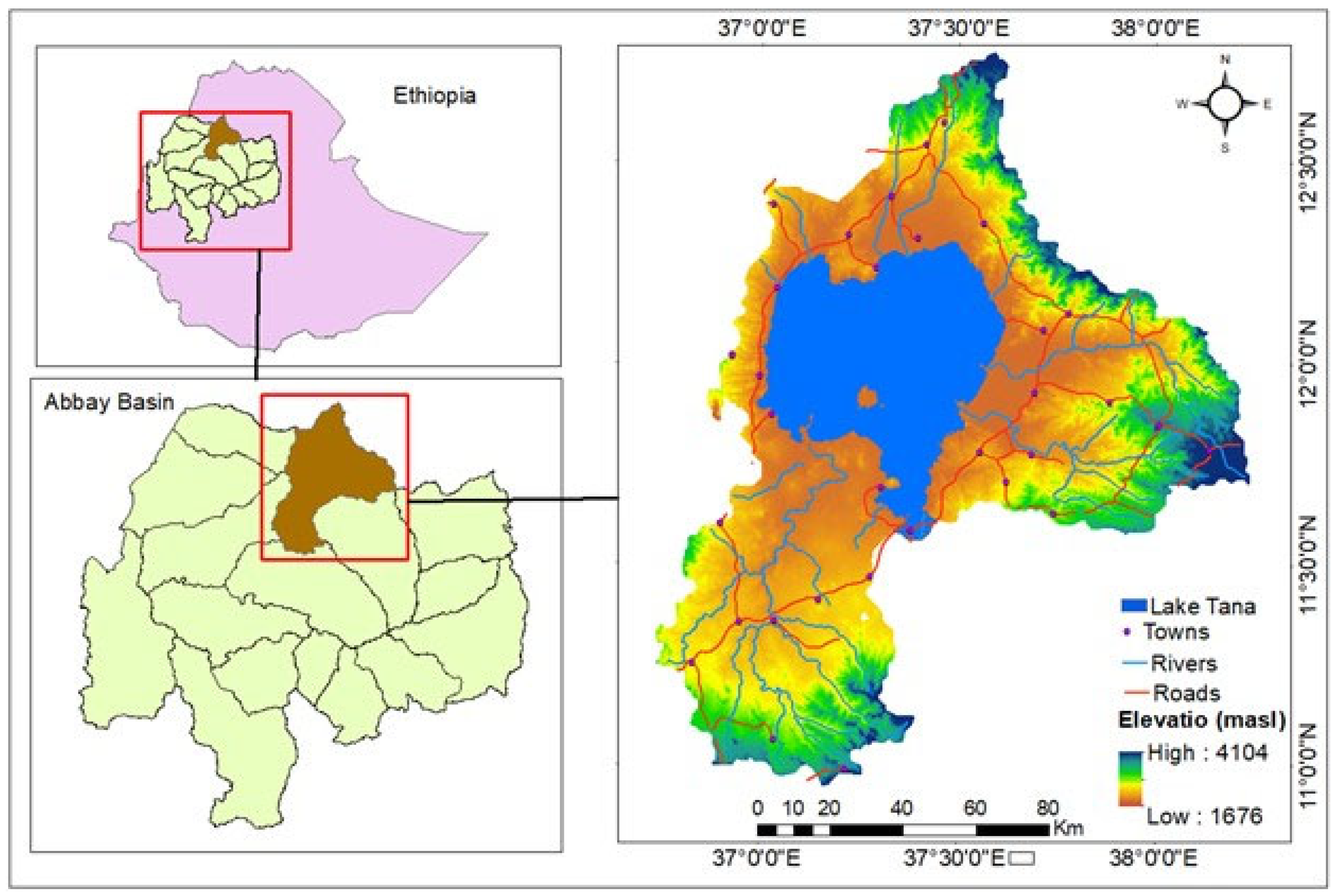
Figure 2.
The general methodology followed to produce ecotourism site suability map.
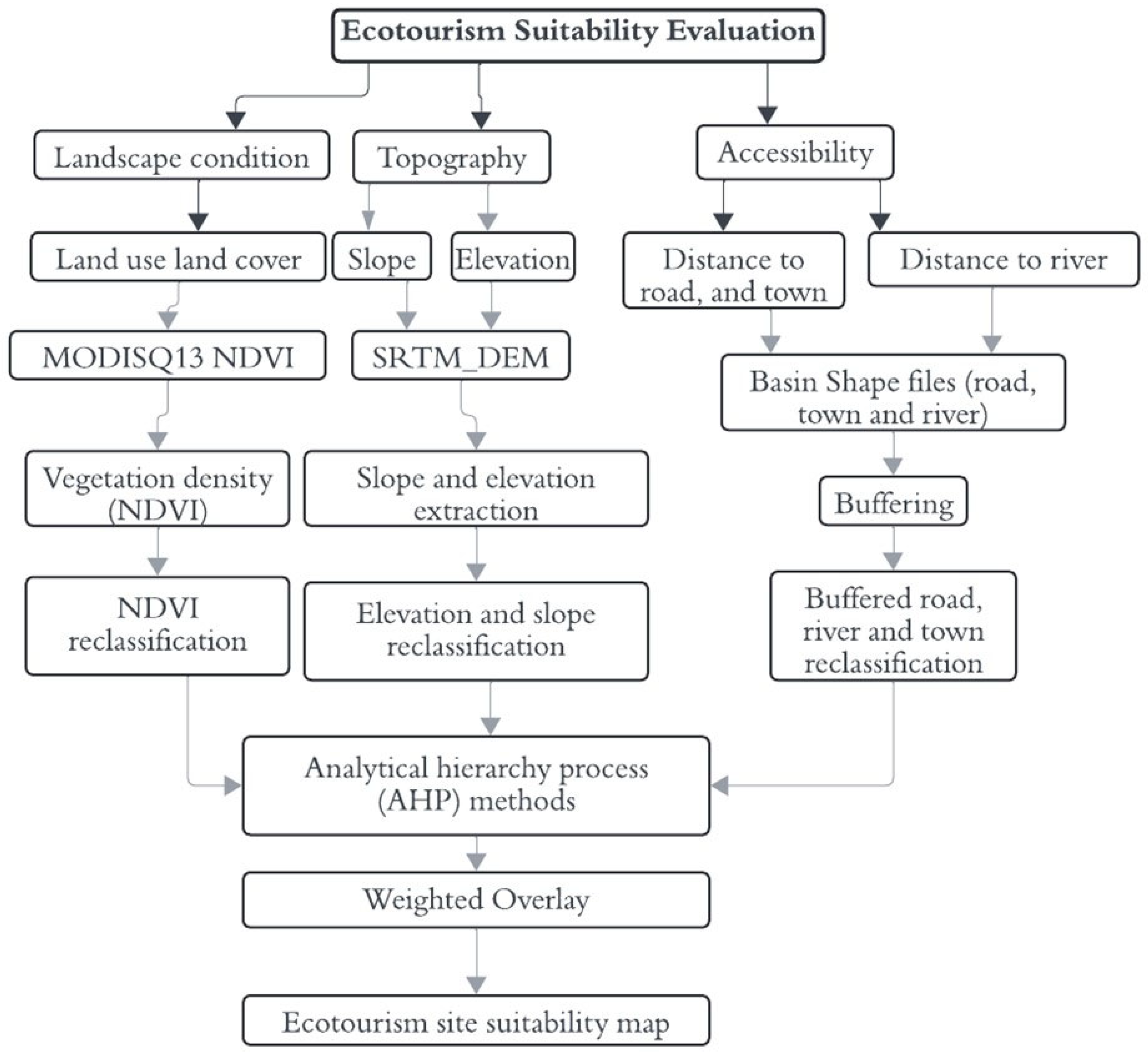
Figure 3.
Spatial distribution of ecotourism site suitability proximity to roads and vegetation density (NDVI).
Figure 3.
Spatial distribution of ecotourism site suitability proximity to roads and vegetation density (NDVI).
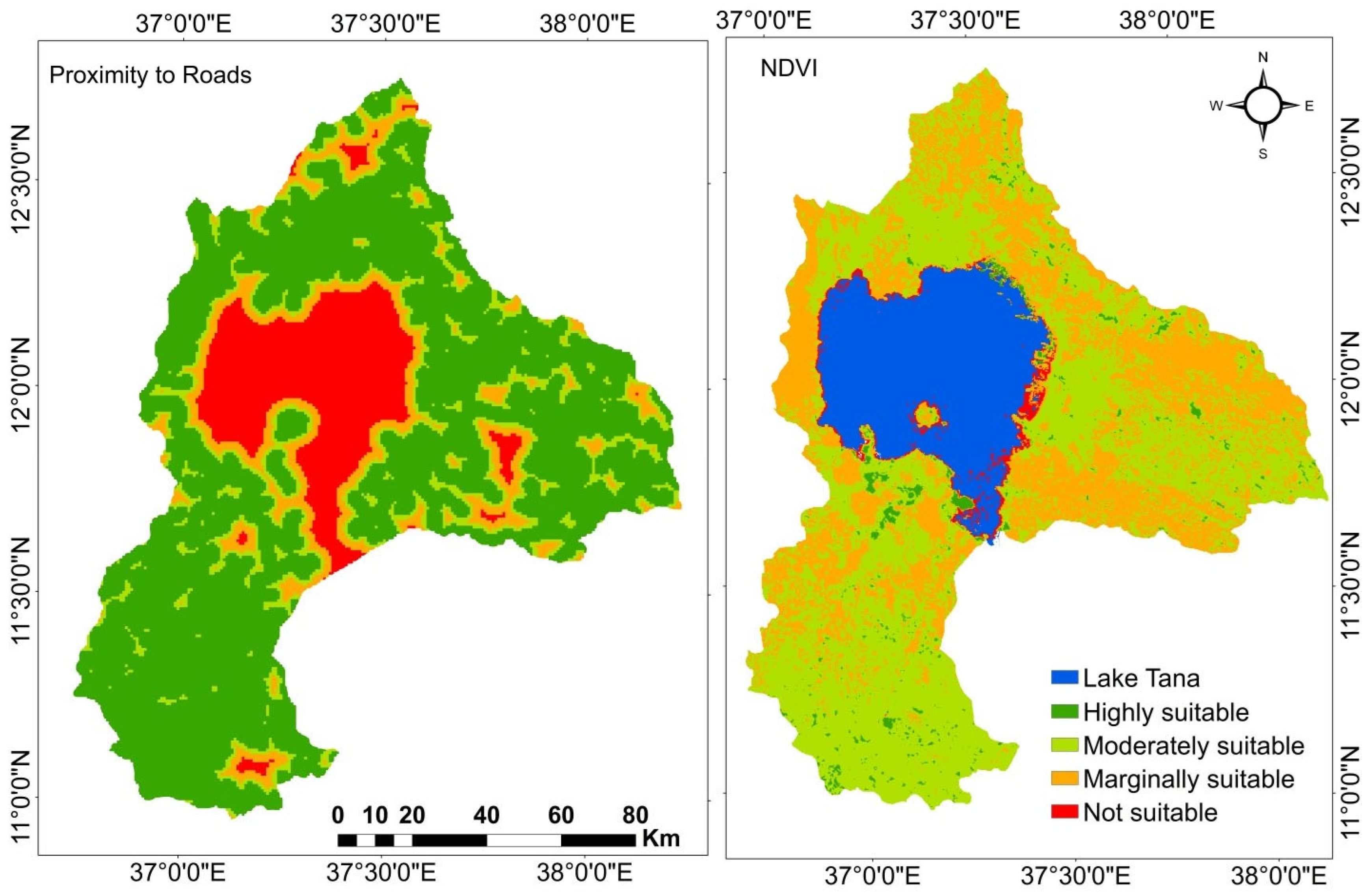
Figure 4.
Spatial distribution of ecotourism site suitability slope, elevation.
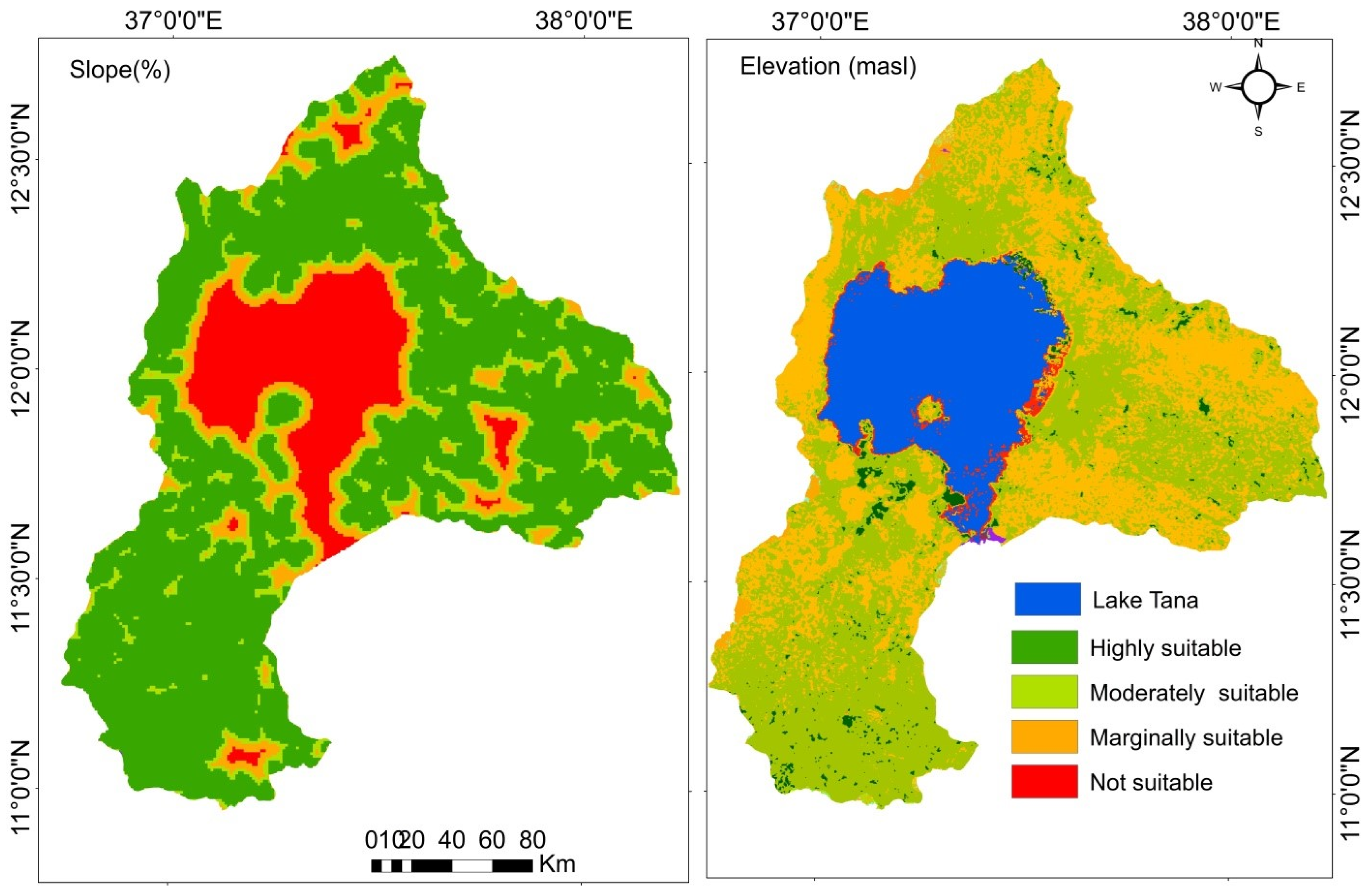
Figure 5.
Spatial distribution of ecotourism site suitability proximity to rivers and town.
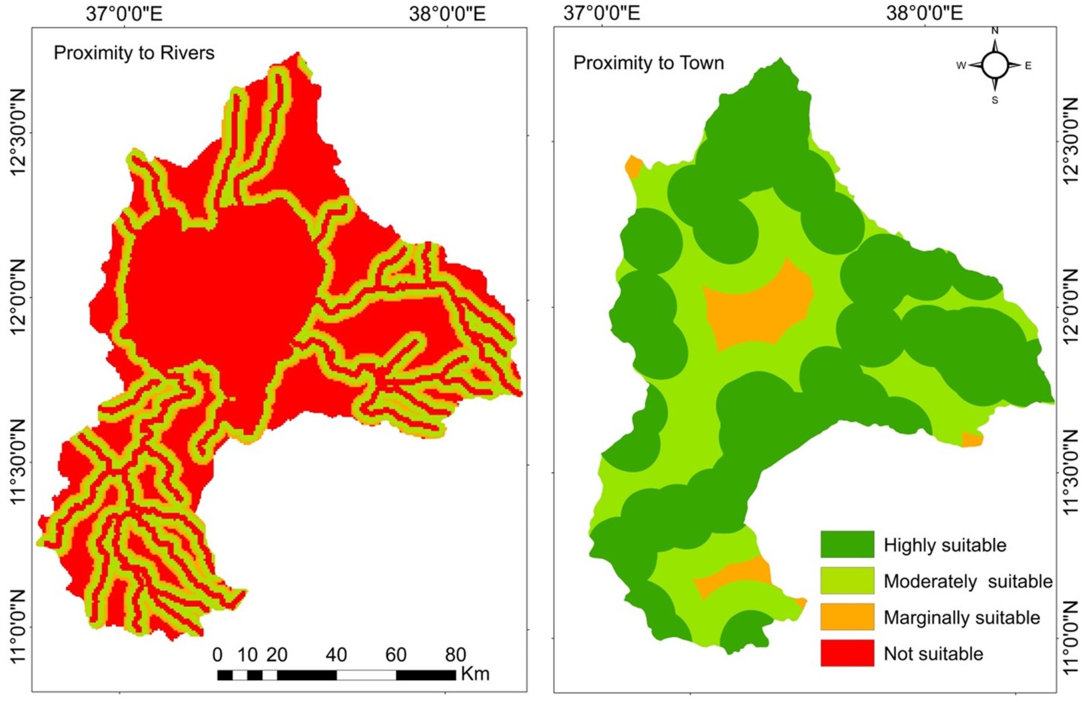
Figure 6.
Ecotourism site suitability map.
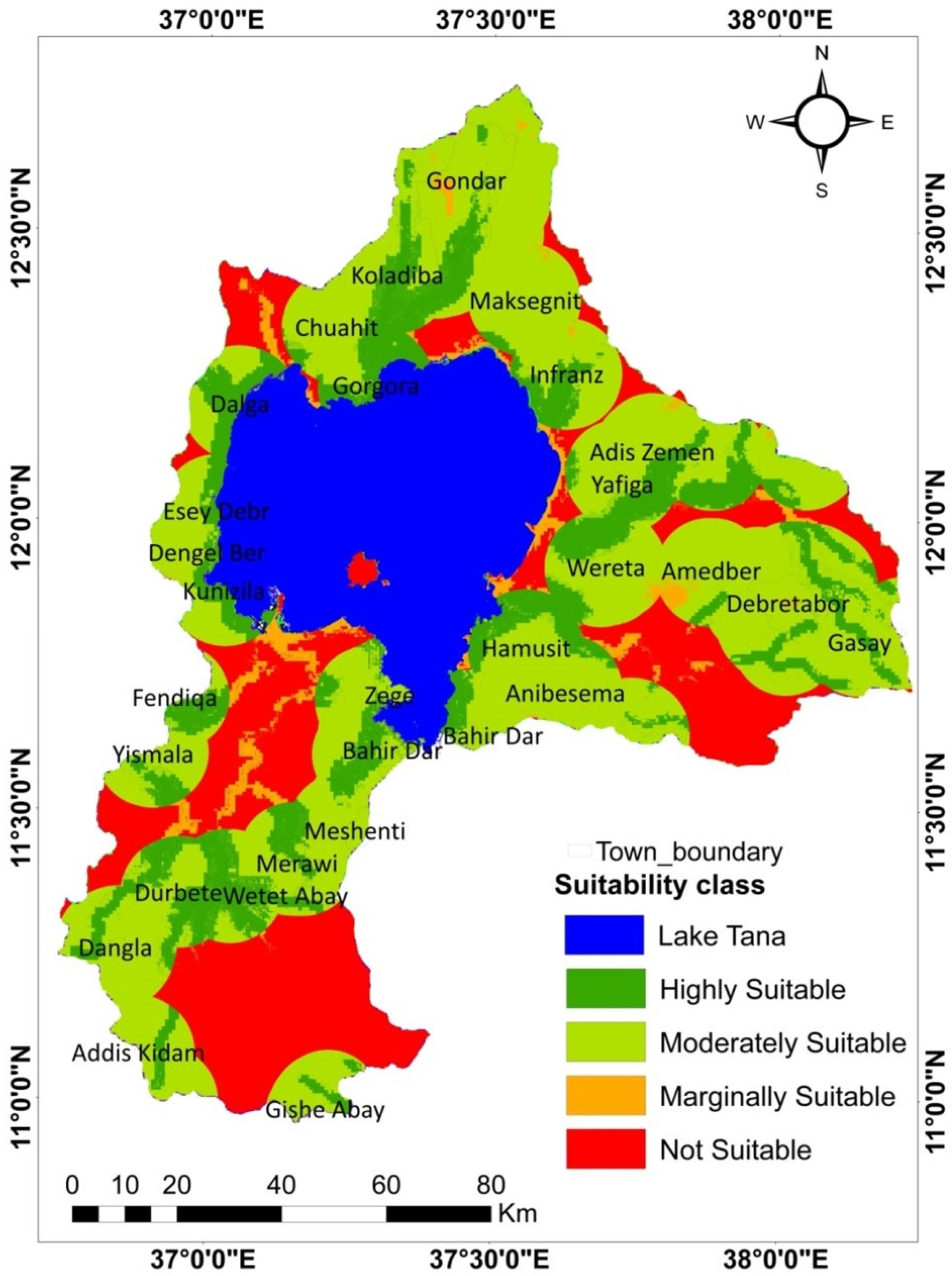
Figure 7.
Prediction rate curve for the suitability map of ecotourism sites.
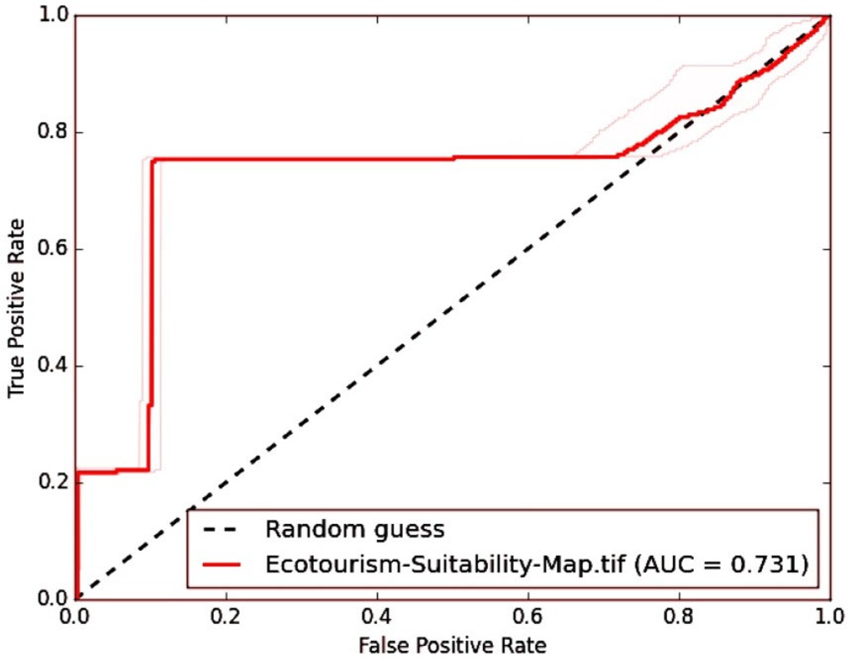

Table 1.
List of data types and their source.
| Data type | Sources |
|---|---|
| Elevation | SRTEM DEM(https://earthexplorer.usgs.gov) |
| Slope | SRTEM DEM(https://earthexplorer.usgs.gov) |
| Distance from Roads | World Digital map and geospatial library (https://maps.princeton.edu) |
| Distance from rivers | World Digital map and geospatial library (https://maps.princeton.edu) |
| Distance from towns | World Digital map and geospatial library (https://maps.princeton.edu) |
| Vegetation cover | MOD13Q1)NDVI(https://earthexplorer.usgs.gov) |
| Local community Perceptions | Interview, field observation and ground control points(GCP) |
Table 2.
Scale value of AHP (source: Saaty 1988).
| Scale | Degree | Interpretation |
|---|---|---|
| 1 | Equally important | The contributions of two factors are equally important |
| 2 | Weak or slight | An intermediate value between adjacent judgment |
| 3 | Moderate importance | Experiences and judgment slightly tend to a certain factor |
| 4 | Moderate plus | An intermediate value between adjacent judgment |
| 5 | Strong importance | Experiences and judgment strongly tend to a certain factor |
| 6 | Strong plus | An intermediate value between adjacent judgment |
| 7 | Very strong importance | Experiences and judgment tend to certain factors with extremely strong |
| 8 | Very, very strong | An intermediate value between adjacent judgment |
| 9 | Extreme importance | There is sufficient evidence for absolutely tending to a certain factor |
| Reciprocals | Opposites | Used for inverse comparison |
Table 3.
Pair wise comparison matrix of factor layers.
| Identified factors | Slope | Proximity to roads | Proximity to town | Proximity to river | Elevation | Vegetation cover (NDVI) | Weight |
|---|---|---|---|---|---|---|---|
| Slope (%) | 1.0 | 0.3 | 0.4 | 0.5 | 0.5 | 0.33 | 6.9 |
| Proximity to road | 3.3 | 1.0 | 0.7 | 2.0 | 0.33 | 0.7 | 16.0 |
| Proximity to town | 2.5 | 1.43 | 1.0 | 0.7 | 2.0 | 0.5 | 19.0 |
| Proximity to river | 2 | 0.5 | 1.43 | 1.0 | 0.8 | 0.6 | 14.5 |
| Elevation | 2.0 | 3.0 | 0.5 | 1.25 | 1.0 | 1.25 | 21.4 |
| Vegetation cover (NDVI) | 5.0 | 1.43 | 2.0 | 1.67 | 0.8 | 1.0 | 22.3 |
| Consistency Ratio (C.R) = 0.079 | |||||||
Table 4.
Identified factors and their suitability classes for ecotourism suitability.
| Variable | Range | Suitability | Area (%) | References |
|---|---|---|---|---|
| Elevation (m asl) | >2000 | Highly suitable | 49.58 | Deribew et al., (2022) |
| 1800-2000 | Moderately suitable | 41.83 | ||
| 1700-1800 | Marginally suitable | 8.59 | ||
| <1700 | Not suitable | 0.00 | ||
| Slope (%) | 0-5 | Highly suitable | 11.19 | |
| 5-25 | Moderately suitable | 66.94 | ||
| 25-35 | Marginally suitable | 10.51 | ||
| >35 | Not suitable | 11.35 | ||
| Distance from Roads(km) | 0-2 | Highly suitable | 68.26 | |
| 2-5 | Moderately suitable | 11.81 | ||
| 5-10 | Marginally suitable | 10.17 | ||
| >10 | Not suitable | 9.75 | ||
| Distance from rivers(km) | 0-1 | Highly suitable | 35.96 | |
| 1-3 | Moderately suitable | 25.89 | ||
| 3-4 | Marginally suitable | 9.99 | ||
| >4 | Not suitable | 28.16 | ||
| Distance from town(Km) | 0-10 | Highly suitable | 62.40 | |
| 10-20 | Moderately suitable | 31.82 | ||
| 20-30 | Marginally suitable | 5.78 | ||
| >30 | Not suitable | 0.00 | ||
| Vegetation cover(NDVI) | 0.61-1 | Highly suitable | 2.23 | Angessa, (2022) |
| 0.31-0.6 | Moderately suitable | 56.64 | ||
| 0.01-3 | Marginally suitable | 39.30 | ||
| -1-0.00 | Not suitable | 1.83 |
Table 5.
Area coverage of ecotourism site suitability classes.
| Class of Suitability | Area in Km2 | Area in % |
|---|---|---|
| Highly suitable | 2326.0 | 20.2 |
| Moderately suitable | 5740.7 | 49.9 |
| Marginally suitable | 400.9 | 3.5 |
| Not suitable | 3028.1 | 26.3 |
Disclaimer/Publisher’s Note: The statements, opinions and data contained in all publications are solely those of the individual author(s) and contributor(s) and not of MDPI and/or the editor(s). MDPI and/or the editor(s) disclaim responsibility for any injury to people or property resulting from any ideas, methods, instructions or products referred to in the content. |
© 2024 by the authors. Licensee MDPI, Basel, Switzerland. This article is an open access article distributed under the terms and conditions of the Creative Commons Attribution (CC BY) license (http://creativecommons.org/licenses/by/4.0/).
Copyright: This open access article is published under a Creative Commons CC BY 4.0 license, which permit the free download, distribution, and reuse, provided that the author and preprint are cited in any reuse.


