
Submitted:
10 May 2023
Posted:
11 May 2023
You are already at the latest version
Abstract
Peri-urban forests often have extensive networks of greenways that allow for outdoor recreation. However, information associated with these greenways often does not include their degree of naturalness, which is usually reduced to descriptions of flora and fauna and often overlook the factors that reduce naturalness. Therefore, in some cases, the naturalness of these greenways is not as high as expected. Having a quantification of their naturalness would be useful, especially for hikers interested in appreciating and enjoying nature. Additionally, this information would help outdoor recreation managers to design trails or decide which ones to promote as "greenways". The objectives of this study are (1) to design a method to calculate and map the naturalness of greenways using two approaches, one based on perceptual fieldwork and the other on Geographic Information Systems (GIS); (2) to apply the designed method to a specific greenway; and (3) to compare both methodological approaches. The results show that, for the greenway studied, the naturalness scores obtained are low in all three types of analyses used. Around 70% of the greenway sections in the GIS visibility analysis and 80% in the GIS proximity analysis have a low naturalness index, while this value is reduced to 40% with the fieldwork analysis. Although the results of the GIS approach (proximity and visibility) generate naturalness indices and spatial patterns that are very similar, they differ significantly from those derived from the fieldwork analysis. The discussion of the results suggests that the three methodologies used are valid for analysing the degree of naturalness of the trails, but if used together, it would be possible to add flexibility to the type of variables incorporated in the analysis.
Keywords:
naturalness
; greenway
; trail assessment
; peri-urban forests
; GIS
; fieldwork
1. Introduction
In the present day, urban populations are subjected, on the one hand, to an overload of work motivated by their work or academic activity, and on the other hand, to living in a degraded environment resulting, among other factors, from pollution. The confluence of these two situations can cause negative impacts on people's health: higher levels of physiological and psychological stress and a higher risk of chronic pathologies, including cardiovascular diseases and mental health problems [1].
In order to counteract these negative effects on health, the World Health Organization (WHO) recommends regular physical activity as it is beneficial for preventing and treating non-communicable diseases (such as cardiovascular diseases) and for mental health [2]. Additionally, according to Kerr et al. [3], the amount of time spent outdoors is related directly to the improvement of the physical and emotional state of individuals. The combination of these two elements, physical activity and outdoor exposure, gives rise to outdoor recreation; an activity that provides psychological, sociological, educational and physical benefits to people's health [4].
When physical activity is performed outdoors in natural environments, it is generally referred to as "green exercise". Several authors [1,5,6,7] consider that "green exercise", when carried out in pleasant natural environments, may have a greater positive effect on mental health and blood pressure, an important indicator of cardiovascular health. In addition, "green exercise" carried out in natural green spaces may have advantages over that carried out in urban green spaces, especially with regard to mental health [1,8]. This may be because natural vegetation provides a sense of privacy and encourages personal relationships and physical exercise, and allows one to distance oneself from routines, which implies isolating oneself from sources of stress [9,10]. The COVID-19 pandemic has encouraged outdoor activities, and therefore the use of hiking trails has increased. Obradović and Tešin's work [11] states that, as a result of the pandemic, there was an increase in the number of people who practiced hiking, that people became more involved in this activity, but perhaps this situation was motivated because other types of activities could not be carried out. Despite this, a large percentage of those surveyed stated that they would continue to practice outdoor hiking when the situation normalised.
Peri-urban forests often feature extensive networks of greenways, paths or trails that offer a unique opportunity to escape the stress of urban life through sport and recreation [12,13,14,15,16]. It has also been found that the availability and accessibility of trails promote an active lifestyle, which in turn increases the likelihood that users will meet physical activity recommendations prescribed by experts [17,18,19,20,21,22,23,24]. Moreover, from a semi-rural or peri-urban location perspective, trails allow for interaction with the natural environment, which, along with the benefits of physical activity, can improve the quality of life for its users [18,21,25].
The satisfying experience of a hike is conditioned by whether the trail's characteristics align with the user's motivations or preferences [11]. If a trail features elements preferred by the user, such as a pleasant landscape, their motivation to walk the trail will increase [8]. Several authors [13,18] establish that trails are mainly used for physical activity. However, in addition to physical exercise, there are other motivations such as cultural, heritage, contact with nature, etc., that drive physical activity on trails [18,22,26,27,28,29,30]. For example, Farías-Torbidoni [26] analyzes the motivations of hikers in natural areas and concludes that the main reason for walking the trail is related directly to nature (connecting with nature, relaxing and disconnecting, and enjoying the landscape). A similar result is obtained by Cordeiro and Alves [31] by establishing that the most important motivating factors for hikers are relaxation and rest, in the first place, and exploration of nature in the second place. In the study by Mayer and Lukács [32], the desire to escape from everyday life and be in a natural environment were revealed as the main motivational factors for hiking trails. The results of Keith et al. [13] establish that, after physical activity, relaxing and escaping from city life, spending time with friends or family, and discovering and experiencing nature are the main motivations for using a trail. Thus, contact with nature is one of the recurring motivations for trail use. Therefore, hiking in forests or natural environments is one of the most sought-after hiking experiences [33]. As shown, several studies confirm a high level of preference for environments with abundant natural vegetation, with natural beauty and contact with nature being one of the main reasons why people use trails [31,33,34,35]. Therefore, evaluating the degree of naturalness or natural interest of the trails would allow potential users to plan their open-air activities based on their main motivation. This way, their level of satisfaction would increase since the experience along the path would adjust to their expectations.
Traditional methodologies that study the characteristics of trails use a series of factors such as the attractiveness of the environment, the type of ground, the conditions of the trail itself, or the natural monuments and attractions present [36]. This method is in line with those applied by hiking federations, such as the European Rambler's Association that issues trail quality seals, such as the "Leading Quality Trails - Best of Europe," and that, to certify them, relies on the quality seal acquisition guide proposed by "Deutsche Wanderverband Service". The collection and evaluation of these factors have traditionally been based on fieldwork, relying mainly on observation and perception, but in recent decades, these methods have been supplanted by GIS [37,38,39,40,41].
In summary, not all hikers have the same interests and motivations, with some prioritising the athletic aspect, others the ecological and naturalistic aspect, and others the recreational and cultural motivation [29,42]. Additionally, user experience improves if the trail characteristics align with their preferences, so evaluating and communicating the degree of naturalness of the trails is a priority for users motivated by contact with nature. Thus, a detailed understanding of the relationships between motivation and trail characteristics can contribute to the design of strategies that increase user satisfaction and provide greater health benefits [27,42]. However, in the process of analysing and evaluating trails, the traditional method of fieldwork has been substituted using GIS tools. The research question posed by this article is whether GIS effectively replace traditional fieldwork methods or whether they are complementary.
This study aims to calculate the naturalness of a greenway, that is, its affinity for the "nature-minded hiker" profile [26], whose main motivation is to appreciate, enjoy and have direct contact with nature. The objectives of the study are: (1) to design a method that allows the calculation and mapping of the naturalness of greenways based on two approaches, one based on fieldwork and the other on GIS; (2) to apply the designed method to the selected greenway and assess its degree of naturalness; and (3) to compare both methodological approaches to contrast the different results, highlighting their respective strengths and weaknesses.
The study is applied to a local and circular greenway called Anella Verda ("Green Ring"), which is 34 km long and mainly runs through the peri-urban forests of the city of Tarragona (Spain). Its choice is due to the fact that it is one of the most used greenways in the area [43] and because the responsible administration (Tarragona city council) promotes it as "green", meaning that it has a strong ecological and naturalness component.
2. Materials and Methods
The methodology is divided into 4 steps (Figure 1). The first step of this methodology consists of selecting a greenway and defining its sections to facilitate the analysis of its degree of naturalness. The second step is to determine a list of factors that influence the naturalness of the selected greenway, either positively or negatively. The third step refers to the collection of data on the selected factors, and in this phase, two different approaches are proposed: through GIS and through perceptual fieldwork. In turn, the GIS method is subdivided into two approaches: proximity analysis and visibility analysis. It is considered that a certain factor, although not directly visible from the greenway, may be nearby and impact the user's perception in some way. For example, there may be no direct visual contact between a greenway user and a nearby wastewater treatment plant. However, this element will potentially produce a different negative impact (acoustic and/or odoriferous) that will be perceived equally by the user, compromising the degree of naturalness of the greenway. Therefore, in this study, it is believed to be appropriate to use both proximity and visibility analyses referring to the GIS method. Finally, the fourth and last methodological step consists of calculating the naturalness index of each section of the greenway according to the three approaches and mapping it.
The segmentation of the greenway into sections (step 1 of the methodology) and its reference length, as well as the selection of most factors that influence the naturalness of a greenway (step 2 of the methodology) are based on the Qualitätsweg Wanderbares (Quality Hiking Trail) guide promoted by the Deutscher Wanderverband (German Hiking Association, DWV - https://www.wanderbares-deutschland.de/service/qualitaetsinitiativen/qualitaetswege). This guide details the requirements that a trail in Germany must meet to be certified as Qualitätsweg Wanderbares Deutschland (Quality Hiking Trail of Wanderbares Deutschland). To achieve this, different parameters of the trail are measured (materials, location, capacity to be enjoyed), the development of the trail as a means of communication, signage, the landscape and natural environment, cultural aspects, and the humanization of the route, among others. This guide is widely recognised and used by prestigious outdoor recreation associations such as the European Ramblers Association (ERA), which awards a seal called Leading Quality Trails - Best of Europe (LQT-BE - https://www.era-ewv-ferp.org/lqt/) to the highest quality trails in Europe with the support of this guide.
2.1. Trail selection and segmentation
The Anella Verda ("Green Ring") runs through the peri-urban area of Tarragona (Catalonia, Spain). This space is a highly fragmented traditional agricultural landscape due to the proliferation of industrial, logistical, commercial, and leisure areas along with the presence of a dense network of infrastructures. The environment of this greenway is considered a chaotic area with many interstitial spaces, although with great potential for outdoor recreation, as it has an extensive network of trails [44].
The selected greenway connects, through two variants, the two rivers that flow into the province of Tarragona (the Francolí and the Gaià), resulting in a great excursion of 34 km in length. Its interior variant mostly runs through peri-urban forests, while the other variant runs along the coastline (Figure 2). The route shows a large part of the extensive historical and cultural heritage of the municipality, passing through a Roman aqueduct, medieval farmhouses, defense towers, Roman quarries, orchards, river mouths, villages of interest, and coves of high natural value.
The greenway layer has been downloaded from the website of the Tarragona City Council in GPX format and has been subdivided into different sections in order to operationalize data collection. For this purpose, the greenway has been segmented using satellite images through photointerpretation based on two criteria. The first (1) considers the morphology of the path and is based on detecting sudden changes, for example, when its width or type of pavement is radically modified. The second (2) establishes a travel distance of around 4 km, following the Qualitätsweg Wanderbares guide.
2.2. Factors selection and sources
For analysing the naturalness of the sections of the Anella Verda, a set of factors has been selected that are mainly based on the Qualitätsweg Wanderbares guide and other studies that evaluate naturalness using multicriteria analysis techniques integrated into a GIS, such as those by Vías and Ocaña [41] and Khazaee Fadafan et al. [38]. The selected factors are grouped into two sets (Table 1), similar to the approach used by Khazaee Fadafan et al. [38]. On the one hand, there are factors related to intensive use of space that may reduce naturalness of the greenway, which could be considered negative factors. On the other hand, there are factors that add naturalness, i.e., those that shape natural landscapes and their figures of protection that determine their relevance from a natural perspective, and all of them are positive factors.
Although there are a large number of factors to use in the analysis, for this study only those present in the study area have been considered. Specifically, through a previous exploration of the cartography associated with the Landscape Catalog of Camp de Tarragona from the Landscape Observatory of Catalonia [45], only the factors within a 500 m influence area from the greenway are included. Those that cannot be measured by the three approaches (GIS visibility, GIS proximity, and fieldwork) at the same time are excluded. In the case of approaches that require the use of GIS (proximity and visibility), the corresponding layers in ESRI Shapefile format have been obtained from the different official organizations detailed in Table 1.
2.3. Factors data collection
The fieldwork has been entirely perceptual or experiential. That is, for each section, the presence of each factor has been analysed, considering a single scale of values from 1 to 5, indicating 1 very little presence and 5 the opposite situation. The fieldwork was carried out in July 2021 by two of the authors of this article, having printed support cartography of all factors to be assessed. During data collection, weather conditions were favorable, i.e., no episodes of wind or rain were experienced. The collected data were entered on analog fieldwork sheets by both operators independently and then the simple average of the evaluations made by each of them was calculated.
In the case of the GIS-based approaches, the analysis has been restricted to an influence area of 500 m. According to Booth et al. [46], landscape characteristics can be separated into two categories based on their proximity to the viewer: aesthetic of view and aesthetic of landscape. The former is determined by the perceived characteristics at great distances, while the latter is limited to the perceived characteristics within a much closer range, typically by viewers within a natural area looking at a patch of landscape around them. Their landscape aesthetic model is limited to evaluating the characteristics of the 1000 m around the observer, based on their professional judgment and knowledge of the study area, although they argue the possibility of adapting this distance to the characteristics of the analysed zone. Following the same criteria and taking into account the characteristics of the study area, this work considers it appropriate to restrict both GIS analyses to the 500 m around each section of the greenway.
For the visibility analysis, visual basins have been calculated using the "visibility analysis" plugin, accessible from the free and open-source software QGIS 3. As a previous step, a layer of viewpoints or observers has been created for each of the greenway sections. To do this, the line layer, which represents the different sections, is transformed into a point layer based on its vertices, which has generated 3716 observation points distributed, according to the section, as shown in Table 2. Attributes related to the observer's height (in this work, the standard value of 1.65 meters for the inhabitants of the study area has been used) and visibility radius (which is 500 m) are associated with this point layer.
After configuring the observation points, the visual basins have been calculated for each section, using the default program values for the sphericity of the Earth and atmospheric refraction index. In this study, due to its advantages in terms of precision and accuracy in modeling the terrain [47,48,49], a Digital Surface Model (DSM) has been used for calculating the visual basins, as they integrate the height of trees and buildings in the visibility calculations. This DSM has been downloaded from the website of the Spanish National Geographic Institute.
This calculation process has been performed 10 times, that is, one for each set of points representing a section of the greenway. The resulting values are transformed into binary values: 0 (not visible) and 1 (visible). Then, the visible surface area in square meters is calculated for each of the 10 sections of the greenway. The visible surface area is the result of multiplying the number of pixels with a value of 1 by the surface area of each pixel, which in this study has been 100 square meters. Finally, to determine the percentage of visible surface area of each factor, its surface area has been calculated by overlaying the layers representing the factors and the visual basin from each section.
In the case of the proximity analysis, the percentage of surface area of each factor within a 500 m buffer around each section was calculated. For this, the "buffer" algorithm of QGIS 3 was used to calculate the 10 buffers, one for each section of the greenway. Next, all layers related to the different factors were clipped using each buffer as the clipping entity. Once the factors were clipped, they were overlaid with the buffers of each section to calculate the proportion of surface area of each factor relative to the total surface area of each buffer. However, for factor "F4b_transport," the percentage of distance of each section that directly intersects with the layer of noise from interurban roads and railways was calculated. Therefore, unlike in the visibility analysis, proximity to the communication routes themselves is not measured, but rather to the noise they generate, one of the negative impacts that these infrastructures can cause [50].
2.4. Naturalness index calculation and mapping
To calculate the naturalness index, the ideal point method is used, adapted from Malczewski [51] and expressed by the following equation:
where xi is the value of factor n in section i; p is the ideal point; a is the anti-ideal point (opposite to the ideal) and N is the total number of factors.
The ideal point method reflects the statistical distance of each case from the ideal situation and is used in this study because, like in Vías and Ocaña [41], it is more appropriate than a mere linear aggregation, since the compensation derived from the use of the arithmetic mean balances situations with different dissimilarity values.
In the analyses derived from the GIS method, the value considered as the ideal point for all factors is 100%, while for the data collected in the fieldwork, this value is 5. As a preliminary step to calculating the formula, the values of the factors belonging to group 1 (intensive use - negative factors) are inverted since, being factors that harm naturalness, the lower the original value collected, the closer they will be to the ideal point of naturalness. For example, if the original value of factor 1 (F1_Industry) was 4.52%, it is inverted and becomes 95.48%, considering 100% as the ideal point.
Considered as a measure of similarity, the result of calculating the part of the formula included in the parentheses means that the value 0 is the ideal point, while 1 is its antithesis. However, following the study by Vías and Ocaña [41] and in order to maintain a logical order of scores (0 indicating lower degree of naturalness and 1 indicating higher degree of naturalness), the value resulting from calculating the parentheses is inverted.
Once the naturalness index of each section has been calculated, they have been mapped using an equal interval classification to be comparable: low naturalness degree (from 0 to 0.33), medium naturalness degree (greater than 0.33 to 0.66), and high naturalness degree (greater than 0.66 to 1).
3. Results
3.1. Trail sections characteristics
The segments that make up the analysed greenway can be classified into three main groups: those that run along the river courses and are located at the eastern and western ends (S1, S2, and partially S6); those in the interior (S3, S4, S5, and partially S6); and finally, the coastal ones (S7, S8, S9, and S10) (Figure 3). In the first group, the presence of the river is the main factor shaping the characteristics, although there are some differences: S1 is a completely urban section that has been configured as a river park and is equipped with urban furniture (fountains, benches, trash cans, etc.) and roads with different characteristics in relation to pavement (artificial, dirt, etc.) or users (bike lane or pedestrian lane); the S2 section corresponds to a wide riverbed, with little riparian vegetation and multiple trail and path options; while the second part of S6 coincides with the final stretch of the Gaià river and has a dense and well-preserved riparian vegetation since it is included in the Protected Natural Space of the Mouth of the Gaià River.
The interior sections offer differences in land use, the presence of unique cultural elements, and distance to fast traffic routes. Thus, in S3, there is the Roman aqueduct of Ferreres, and in the first part of S6, the Roman quarry of Mèdol, both of which are first-rate historical and cultural attractions. In addition, throughout the set of interior sections, examples of scattered traditional architecture (farmhouses) appear. S3 runs mostly through wooded areas and is located away from fast traffic routes, while in S4 and S5, and the first part of S6, there is a mosaic of forests, abandoned or non-abandoned agricultural areas, and low-intensity residential areas. Finally, it is noteworthy that the entirety of S4 runs parallel and adjacent to fast traffic routes.
The coastal sections are arranged from east (S7) to west (S10) and are characterised by a greater or lesser degree of urbanization in their immediate hinterland and by the distance to the railway line. Thus, S7 starts at the Castle of Tamarit and corresponds to a beach surrounded by low-density urbanization. S8 runs through the protected natural space of the Bosc de la Marquesa, which has been preserved thanks to the railway line acting as a barrier to urbanization. S9 and S10 correspond to beaches with the railway line parallel to the coast and very close, with an urban or practically urban hinterland.
3.2. Factors mapping
Figure 4a shows the factors used to assess the naturalness of the greenway, which are described previously. The factors that detract from the naturalness of the extensive surface landscape have a differentiated behavior. Industry (F1_industry) is concentrated in the western sector, while urban areas (F5_urban) have a large surface area corresponding to the city of Tarragona adjacent to the industry, and a series of randomly distributed patches in the entire study area (low-density residential area). The linear factors (F2_voltage, F4_transport in both variants) cross the territory horizontally, from east to west, although the network of communication routes is denser in the western sector. It should be noted that the transportation factor used in the proximity analysis (F4b_transport) corresponds to a polygon that, in its western section, occupies a good part of the territory. The factors that add naturalness to the landscape are mostly superficial in nature, from F6 to F9, with a greater profusion in the eastern sector of the study area, most of them located in the interior zone, except for the aesthetic coastal landscape located on the coast, also in the east. Finally, it should be noted that in the river factor (F10_rivers), they are located at the ends and have a vertical (N-S) disposition.
Since the GIS analysis is carried out from two approaches, visibility and proximity, a visual basin has been generated for the first case (Figure 4b) that covers an area of 17.53 km2, and an influence area or buffer for the second case that delimits a polygon equidistant to 500 meters from the Anella Verda and has an area of 37.98 km2 (Figure 4c).
3.3. Trail naturalness assessment
The results of the naturalness index calculated for each section are different for the three methodological approaches proposed (Figure 5). First, according to the GIS visibility analysis, 70% of the sections have a naturalness score of less than 0.33 and the remaining 30% (S7, S8 and S9) have an intermediate naturalness. No section with a high naturalness index is identified. Spatially, the three sections that have an intermediate level of naturalness are contiguous and entirely on the coastal axis of the greenway.
Secondly, the results of the proximity GIS analysis follow a very similar pattern to the previous one, with 80% of the sections having a low degree of naturalness. The remaining 20% (S7 and S8) do not exceed a score of 0.66, placing them in an intermediate level of naturalness. With this analysis, no sections appear to have a naturalness index higher than 0.66. The spatial pattern is identical to the previous one, except for S9, which, with a score of 0.32, is located at a low level of naturalness.
Thirdly, in the fieldwork, greater variability is observed, both in the scores of the sections and in their spatial pattern. Specifically, less than half of the sections (40%) obtain a low naturalness score, half obtain an intermediate level of naturalness, and the remaining section (S8) is the only one that obtains a high naturalness score (0.70). From the spatial pattern, it can be deduced that the coastal sections have a higher naturalness index than the rest, with S8 standing out where several positive factors (F6_forest, F7_n2000, F8_coast, F9_faunaflora, and F11_sea) coincide spatially while lacking negative factors that reduce naturalness.
3.4. Method comparison
The results obtained through the three methodological approaches to the naturalness of the sections of the greenway show, in general, low values of naturalness, which are consistent with the degree of human intervention in this territory. This area is located near the city of Tarragona, with many urbanised areas and occupied by various human activities.
Out of the 10 sections analysed, in half of them (S1, S2, S4, S5, and S7), the three methodological approaches coincide in the naturalness class (Figure 6), while in the other half of the sections (S3, S6, S8, S9, and S10) at least two methodological approaches coincide. No section was found where the three approaches offered a different naturalness class in each one. In all sections, at least 2 approaches coincide.
The sections S1, S2, S4, and S5 have the same value of naturalness, which is low, meaning they have little naturalness. The main feature that identifies them is the high presence of low-density residential areas, except in S2 where the low naturalness is due to the existence of industrial areas and power lines.
In section S7, the three methodological approaches also agree, but this time the naturalness increases to the medium class due to the lower residential urbanization and the increase of positive elements such as the presence of forests, protected areas, coastal landscape, and relevant species of flora and fauna.
The coincidence of the degree of naturalness, according to the three approaches, has been observed mostly in the eastern area (highly urbanised), northern area, and one section in the southern area. On the other hand, the southern area is the most heterogeneous in terms of naturalness results, as of the four sections, only one is coincident in the three approaches, while the other three (S8, S9, and S10) only coincide in two. S10 and S8 are coincident in the methodological approaches with GIS (proximity and visibility) in which the values of natural landscapes and water landscapes are dominant. In contrast, in S9, the presence of the sea is very important, and this is where the results of visibility and fieldwork coincide.
4. Discussion
The information associated with an official trail usually does not provide an indicator that quantifies its degree of naturalness; the signs, brochures, and other available documentation typically only describe the characteristics of the fauna and flora of the greenway in question [52]. The availability of information on the degree of naturalness of a trail at the time of choosing a greenway or a section of it to travel would be very useful for users, but especially for the profile of hiker interested in appreciating and enjoying nature. Despite the advantages that knowledge of the degree of naturalness of a trail could provide to its users, there is a limited number of studies that address this topic (e.g. [39,41,50,53,54,55]).
This study demonstrates that, although the administration promotes the analysed greenway as "green" and "natural", it does not have the degree of naturalness that a nature-minded hiker would likely expect to find. In this regard, similarities have been found with the study by Vías and Ocaña [41], in which a multi-criteria evaluation model integrated into a GIS was used to assess the suitability of a network of trails for hiking. One of the criteria included in the generated model was natural interest, and as a result of this criterion, they found that more than three-quarters of the analysed sections had a natural interest below average, which can be considered a low value in the context of that study area (the Sierra de las Nieves natural protected area in southern Spain). Similarly, in the work by Pavão et al. [39], the hypothesis was made that natural forest could have a relevant role as a tourist attraction for the trails in the Azores (Portugal). To demonstrate this hypothesis, a quantitative analysis based on GIS was applied to determine the predominant types of covers found along these trails. They concluded that the predominant ground covers along the routes in this nature tourism destination correspond to anthropogenic landscapes of low naturalness (e.g., reforested forests, artificial pastures, or invasive forests).
Table 3 summarizes the applied methodologies in this study. In terms of analysis speed, establishing the perception of naturalness through fieldwork is considered the slowest method. On the other hand, the fastest method is proximity to the trail using GIS tools. For the visibility analysis (the third method used), more layers are needed, and the calculation of visual basins requires more processing time. The cost behavior also shows differences between fieldwork and GIS methods. The former requires a high and continuous budget for personnel to carry out data collection campaigns, while in GIS, the investment is initial and dedicated to the purchase of hardware since free GIS software can be used, and the necessary information layers are usually available free of charge from institutions responsible for cartography. This cost difference is accentuated if we consider that, although computer equipment is not necessary during the collection of information in perceptual fieldwork, it is used in the subsequent treatment of the data.
One important aspect to consider is the selection of factors that will be part of the analysis model for the degree of naturalness. In the case of perceptual fieldwork, the limitations in selecting factors are very low since, based on perception, any factor can be collected, such as bad smells or presence of garbage. The only limitation detected is based on the time dedicated to this task, which is very demanding. In the case of GIS, the selection of factors is based on technical criteria considering the availability and scale of cartography, which for some factors are difficult to find or due to the absence of information or not at an appropriate scale. Furthermore, in visibility analysis with GIS, these limitations are increased since, in addition to obtaining information layers, an additional layer, the Digital Surface Model (DSM), is required to calculate visual basins. In the selection of factors, it is considered that fieldwork is more versatile since it can incorporate factors easily since it is only based on perception. Due to the characteristics of perception-based fieldwork, the risk of variations in the assessment of factors is very high since, despite having detailed descriptors for each category of the range, external factors such as weather conditions or the experience and judgment of technicians performing the assessment can be different. This situation is diametrically opposed to the use of GIS, which, by applying the same parameters, obtains equivalent results for any section and situation.
Regarding the initial research question, it has been found that the results obtained from the comparison of methods show that, if a quick analysis is required, the best option is to use proximity analysis based on GIS. However, if time and budget are available, the fieldwork technique can be used, which also provides greater flexibility when selecting factors.
According to the results obtained from this study, it is not possible to affirm that GIS completely substitutes fieldwork, but rather that both methodologies are complementary. It is considered that the three methods applied are valid independently when measuring the degree of naturalness of a trail. However, in an integrated methodology, GIS would provide a quick and objective analysis, while fieldwork could introduce, on the one hand, factors that are not usually available in cartographic layers such as the presence of trash or bad odors and, on the other hand, information related to the user's emotions or experiences, such as the attractiveness of a picturesque place or the tranquility of a forest. This complementarity between GIS and fieldwork has already been used by other authors in other contexts, leading to satisfactory results (e.g. [56,57,58]).
In any case, it is considered that the administration should expand the available information on the degree of naturalness of the trails with the intention that when the user makes their choice, it fits their motivations and preferences to increase their level of satisfaction [11]. In addition to increasing the level of satisfaction, having this information can encourage outdoor recreational and sports activities with the potential positive effects on the health and well-being of people.
The main methodological limitations of this study are related to the segmentation of the original greenway into sections and the area of influence used. In this work, criteria related to the longitudinal homogeneity of the sections and their own characteristics are used to segment the trail. Other works, such as that of Vías and Ocaña [41], use intersections with other trails to establish the different section breakpoints. Therefore, depending on how the criterion is established to locate these section breakpoints, the segmentation of the itinerary can directly influence the final calculations of naturalness for each section. Additionally, in the specific case of the GIS approach, the determination of the area of influence (both for visibility analysis and proximity analysis), which in this study was 500 m, can also affect the results.
Additionally, it is important to consider that the replicability of this method is limited by the adaptation of the factors to each specific case study. That is, depending on the characteristics of the analysed greenway and the study area in which it is located, the factors to include, both for GIS analysis and fieldwork analysis, may vary. This makes it difficult to replicate the method in another study area without first conducting a diagnosis of the present factors to customize the selection. For example, the same factors cannot be used to measure the degree of naturalness of a path that runs through a desert area or a forest, or an inland area versus a coastal area.
5. Conclusions
The three analyses applied in this study (two through GIS and the other with fieldwork) are shown to be valid for calculating the degree of naturalness of a greenway. However, from the discussion of the results, it is concluded that the integration of both techniques (GIS and fieldwork) can lead to more precise and detailed results in trail naturalness assessment.
For this case study, the two GIS analyses obtain similar naturalness indices, although the values are always lower compared to those derived from the fieldwork analysis. Additionally, although the greenway analysed in this study is promoted as "green," the resulting naturalness indices are generally low in all three methods used. This suggests that this type of itinerary or trail does not always meet expectations, meaning it does not have the degree of naturalness that users would expect to find.
The results obtained from both the analysed greenway and the replication of this methodology in other study areas could be of great use for land and outdoor recreation managers. On the one hand, it could help them design trails by selecting those segments with the highest naturalness, and on the other hand, it could help them promote these trails. For hikers, it means having more and higher quality information about the naturalness of greenways in the decision-making process prior to using a particular greenway or section thereof.
Author Contributions
All authors (A.A.C., Y.P.-A. and J.V.M.) contributed equally to conceptualizing, writing and reviewing this work. All authors have read and agreed to the published version of the manuscript.
Funding
This research was funded by MCIN/AEI/ 10.13039/501100011033, grant number PID2020-114363GB-I00.
Data Availability Statement
Not applicable.
Acknowledgments
This article has been possible with the support of the grant PRE2018-084802 funded by MCIN/AEI/ 10.13039/501100011033 and by “ESF Investing in your future”.
Conflicts of Interest
The authors declare no conflict of interest. The funders had no role in the design of the study; in the collection, analyses, or interpretation of data; in the writing of the manuscript; or in the decision to publish the results.
References
- Li, H.; Zhang, X.; Bi, S.; Cao, Y.; Zhang, G. Psychological Benefits of Green Exercise in Wild or Urban Greenspaces: A Meta-Analysis of Controlled Trials. Urban For. Urban Green. 2022, 68. [Google Scholar] [CrossRef]
- WHO. Guidelines on Physical Activity and Sedentary Behaviour. Geneva World Heal. Organ. 2020, 1–582. [Google Scholar]
- Kerr, J.; Marshall, S.; Godbole, S.; Neukam, S.; Crist, K.; Wasilenko, K.; Golshan, S.; Buchner, D. The Relationship between Outdoor Activity and Health in Older Adults Using GPS. Int. J. Environ. Res. Public Health 2012, 9, 4615–4625. [Google Scholar] [CrossRef] [PubMed]
- Breitenstein, D.; Ewert, A. Health Benefits of Outdoor Recreation: Implications for Health Education. Health Educ. 1990, 21, 16–21. [Google Scholar] [CrossRef]
- Barton, J.; Pretty, J. The Beneficial Effects of Green Exercise on Health. In Forest Medicine; Nova Science Publishers, Inc., 2013; pp. 201–219 ISBN 9781626184626 (ISBN).
- Calogiuri, G.; Elliott, L.R. Why Do People Exercise in Natural Environments? Norwegian Adults’ Motives for Nature-, Gym-, and Sports-Based Exercise. Int. J. Environ. Res. Public Health 2017, 14. [Google Scholar] [CrossRef] [PubMed]
- Hill, E.; Gómez, E. Perceived Health Outcomes of Mountain Bikers: A National Demographic Inquiry. J. Park Recreat. Admi. 2020, 38, 1–16. [Google Scholar] [CrossRef]
- Davies, N.J.; Lumsdon, L.M.; Weston, R. Developing Recreational Trails: Motivations for Recreational Walking. Tour. Plan. Dev. 2012, 9, 77–88. [Google Scholar] [CrossRef]
- Fumagalli, N.; Maccarini, M.; Rovelli, R.; Berto, R.; Senes, G. An Exploratory Study of Users’ Preference for Different Planting Combinations along Rural Greenways. Sustain. 2020, 12. [Google Scholar] [CrossRef]
- Senes, G.; Rovelli, R.; Bertoni, D.; Arata, L.; Fumagalli, N.; Toccolini, A. Factors Influencing Greenways Use: Definition of a Method for Estimation in the Italian Context. J. Transp. Geogr. 2017, 65, 175–187. [Google Scholar] [CrossRef]
- Obradović, S.; Tešin, A. Hiking in the COVID-19 Era: Motivation and Post-Outbreak Intentions. J. Sport Tour. 2022, 26, 147–164. [Google Scholar] [CrossRef]
- Chen, X.; de Vries, S.; Assmuth, T.; Dick, J.; Hermans, T.; Hertel, O.; Jensen, A.; Jones, L.; Kabisch, S.; Lanki, T.; et al. Research Challenges for Cultural Ecosystem Services and Public Health in (Peri-)Urban Environments. Sci. Total Environ. 2019, 651, 2118–2129. [Google Scholar] [CrossRef] [PubMed]
- Keith, S.J.; Larson, L.R.; Shafer, C.S.; Hallo, J.C.; Fernandez, M. Greenway Use and Preferences in Diverse Urban Communities: Implications for Trail Design and Management. Landsc. Urban Plan. 2018, 172, 47–59. [Google Scholar] [CrossRef]
- Komossa, F.; Wartmann, F.M.; Kienast, F.; Verburg, P.H. Comparing Outdoor Recreation Preferences in Peri-Urban Landscapes Using Different Data Gathering Methods. Landsc. Urban Plan. 2020, 199. [Google Scholar] [CrossRef]
- Komossa, F.; van der Zanden, E.H.; Verburg, P.H. Characterizing Outdoor Recreation User Groups: A Typology of Peri-Urban Recreationists in the Kromme Rijn Area, the Netherlands. Land use policy 2019, 80, 246–258. [Google Scholar] [CrossRef]
- Žlender, V.; Ward Thompson, C. Accessibility and Use of Peri-Urban Green Space for Inner-City Dwellers: A Comparative Study. Landsc. Urban Plan. 2017, 165, 193–205. [Google Scholar] [CrossRef]
- Brownson, R.C.; Housemann, R.A.; Brown, D.R.; Jackson-Thompson, J.; King, A.C.; Malone, B.R.; Sallis, J.F. Promoting Physical Activity in Rural Communities: Walking Trail Access, Use, and Effects. Am. J. Prev. Med. 2000, 18, 235–241. [Google Scholar] [CrossRef] [PubMed]
- Corning, S.E.; Mowatt, R.A.; Chancellor, H.C. Multiuse Trails: Benefits and Concerns of Residents and Property Owners. J. Urban Plan. Dev. 2012, 138, 277–285. [Google Scholar] [CrossRef]
- Evenson, K.R.; Herring, A.H.; Huston, S.L. Evaluating Change in Physical Activity with the Building of a Multi-Use Trail. Am. J. Prev. Med. 2005, 28, 177–185. [Google Scholar] [CrossRef]
- Neff, L.J.; Ainsworth, B.E.; Wheeler, F.C.; Krumwiede, S.E.; Trepal, A.J. Assessment of Trail Use in a Community Park. Fam. Community Heal. 2000, 23, 76–84. [Google Scholar] [CrossRef]
- Schasberger, M.G.; Hussa, C.S.; Polgar, M.F.; McMonagle, J.A.; Burke, S.J.; Gegaris Jr., A.J. Promoting and Developing a Trail Network across Suburban, Rural, and Urban Communities. Am. J. Prev. Med. 2009, 37, S336–S344. [Google Scholar] [CrossRef]
- Wan Omar, W.R.; Patterson, I.; Pegg, S. A Green Pathway for Future Tourism Success: Walking Trails in Kuala Lumpur. Tour. Plan. Dev. 2012, 9, 57–76. [Google Scholar] [CrossRef]
- Wang, G.; Macera, C.A.; Scudder-Soucie, B.; Schmid, T.; Pratt, M.; Buchner, D. Cost Effectiveness of a Bicycle/Pedestrian Trail Development in Health Promotion. Prev. Med. (Baltim). 2004, 38, 237–242. [Google Scholar] [CrossRef] [PubMed]
- Xie, B.; Lu, Y.; Zheng, Y. Casual Evaluation of the Effects of a Large-Scale Greenway Intervention on Physical and Mental Health: A Natural Experimental Study in China. Urban For. Urban Green. 2022, 67. [Google Scholar] [CrossRef]
- Park, T.; Eyler, A.A.; Tabak, R.G.; Valko, C.; Brownson, R.C. Opportunities for Promoting Physical Activity in Rural Communities by Understanding the Interests and Values of Community Members. J. Environ. Public Health 2017, 2017. [Google Scholar] [CrossRef]
- Farías-Torbidoni, E.I. Managing for Recreational Experience Opportunities: The Case of Hikers in Protected Areas in Catalonia, Spain. Environ. Manage. 2011, 47, 482–496. [Google Scholar] [CrossRef] [PubMed]
- Farías-Torbidoni, E.I.; Grau, R.; Camps, A. Trail Preferences and Visitor Characteristics in Aigüestortes i Estany de Sant Maurici National Park, Spain. Mt. Res. Dev. 2005, 25, 51–59. [Google Scholar] [CrossRef]
- Farías-Torbidoni, E.I.; Mas-Alòs, S.; Gil-Moreno-de-Mora, G.; Lavega-Burgués, P.; Castañer, M.; Lorente-Catalán, E.; Seguí-Urbaneja, J.; Lacasa-Claver, E. Health and Well-Being in Protected Natural Areas—Visitors’ Satisfaction in Three Different Protected Natural Area Categories in Catalonia, Spain. Int. J. Environ. Res. Public Health. 2020, 17. [Google Scholar] [CrossRef]
- Vías, J.; Rolland, J.; Castillo, S.; del Campo-Ávila, J.; Luque, A. Creación de Rutas Senderistas Mediante Análisis de Redes y Algoritmo Multicriterio. Aplicación En El Parque Natural Sierra de Las Nieves. XVI Congr. Nac. Tecnol. la Inf. Geográfica. 2014, 947–953. [Google Scholar]
- Watts, G.; Bauer, J. Tranquillity Trails–Design, Implementation and Benefits for Healthy Leisure. World Leis. J. 2021. [Google Scholar] [CrossRef]
- Cordeiro, B.; Alves, L. Protected Areas, Tourism and Hiking Trails. The Hiker’s Profile in Serra Da Lousã (Portugal). PASOS Rev. Tur. y Patrim. Cult. 2022, 20, 939–949. [Google Scholar] [CrossRef]
- Mayer, K.; Lukács, A. Motivation and Mental Well-Being of Long-Distance Hikers: A Quantitative and Qualitative Approach. Heliyon 2021, 7. [Google Scholar] [CrossRef] [PubMed]
- Saayman, M.; Viljoen, A. Who Are Wild Enough to Hike a Wilderness Trail? J. Outdoor Recreat. Tour. 2016, 14, 41–51. [Google Scholar] [CrossRef]
- Gaffar, V.; Yuniawati, Y.; Ridwanudin, O. A STUDY OF OUTDOOR RECREATION MOTIVATION AND ACTIVITY PREFERENCES. Xinan Jiaotong Daxue Xuebao/Journal Southwest Jiaotong Univ. 2019, 54. [Google Scholar] [CrossRef]
- Lee, J.; Lee, H.-S.; Jeong, D.; Shafer, C.S.; Chon, J. The Relationship between User Perception and Preference of Greenway Trail Characteristics in Urban Areas. Sustain. 2019, 11. [Google Scholar] [CrossRef]
- Molokáč, M.; Hlaváčová, J.; Tometzová, D.; Liptáková, E. The Preference Analysis for Hikers’ Choice of Hiking Trail. Sustain. 2022, 14. [Google Scholar] [CrossRef]
- Beeco, J.A.; Hallo, J.C.; Brownlee, M.T.J. GPS Visitor Tracking and Recreation Suitability Mapping: Tools for Understanding and Managing Visitor Use. Landsc. Urban Plan. 2014, 127, 136–145. [Google Scholar] [CrossRef]
- Khazaee Fadafan, F.; Soffianian, A.; Pourmanafi, S.; Morgan, M. Assessing Ecotourism in a Mountainous Landscape Using GIS – MCDA Approaches. Appl. Geogr. 2022, 147. [Google Scholar] [CrossRef]
- Pavão, D.C.; Porteiro, J.; Ventura, M.A.; Borges Silva, L.; Medeiros, A.; Moniz, A.; Moura, M.; Moreira, F.; Silva, L. Land Cover along Hiking Trails in a Nature Tourism Destination: The Azores as a Case Study. Environ. Dev. Sustain. 2021, 23, 16504–16528. [Google Scholar] [CrossRef]
- Peterson, B.A.; Brownlee, M.T.J.; Marion, J.L. Mapping the Relationships between Trail Conditions and Experiential Elements of Long-Distance Hiking. Landsc. Urban Plan. 2018, 180, 60–75. [Google Scholar] [CrossRef]
- Vías, J.; Ocaña, C. Multicriteria Evaluation by GIS to Determine Trail Hiking Suitability in a Natural Park. Bol. la Asoc. Geogr. Esp. 2014, 323–339. [Google Scholar]
- Vías, J.; Rolland, J.; Gómez, M.L.; Ocaña, C.; Luque, A. Recommendation System to Determine Suitable and Viable Hiking Routes: A Prototype Application in Sierra de Las Nieves Nature Reserve (Southern Spain). J. Geogr. Syst. 2018, 20, 275–294. [Google Scholar] [CrossRef]
- Àvila Callau, A. El Análisis de Los Servicios Ecosistémicos Culturales a Partir de Información Geográfica Voluntaria. El Caso Del Periurbano de Tarragona, Universitat Rovira i Virgili, Tarragona, 2022.
- Àvila Callau, A.; Pérez-Albert, Y.; Serrano Giné, D. Quality of GNSS Traces from VGI: A Data Cleaning Method Based on Activity Type and User Experience. ISPRS Int. J. Geo-Information. 2020, 9. [Google Scholar] [CrossRef]
- Observatori del Paisatge. Catàleg de Paisatge Del Camp de Tarragona; 2010.
- Booth, P.N.; Law, S.A.; Ma, J.; Buonagurio, J.; Boyd, J.; Turnley, J. Modeling Aesthetics to Support an Ecosystem Services Approach for Natural Resource Management Decision Making. Integr. Environ. Assess. Manag. 2017, 13, 926–938. [Google Scholar] [CrossRef] [PubMed]
- Klouček, T.; Lagner, O.; Šímová, P. How Does Data Accuracy Influence the Reliability of Digital Viewshed Models? A Case Study with Wind Turbines. Appl. Geogr. 2015, 64, 46–54. [Google Scholar] [CrossRef]
- Noblejas, H.C.; Martínez, J. V; Rodríguez, M.F.M. Relation between the Views and the Real Estate Application to a Mediterranean Coastal Area. ISPRS Int. J. Geo-Information 2022, 11. [Google Scholar] [CrossRef]
- Pellicer, I.; Estornell, J.; Martí, J. Application of Airborne LiDA R Data in Viewshed Analysis. Rev. Teledetec. 2014, 9–18. [Google Scholar] [CrossRef]
- Malec, M.; Kędzior, R.; Ziernicka-Wojtaszek, A. The Method of Soundscape Naturalness Curves in the Evaluation of Mountain Trails of Diversified Anthropopressure—Case Study of Korona Beskidów Polskich. Sustain. 2023, 15. [Google Scholar] [CrossRef]
- Malczewski, J. GIS and Multicriteria Decision Analysis; John Wiley & Sons: New York, 1999; ISBN 0471329444. [Google Scholar]
- Weis, K.; Hronček, P.; Tometzová, D.; Gregorová, B.; Přibil, M.; Jesenský, M.; Čech, V. Analysis of Notice Boards (Panels) as General Information Media in the Outdoor Mining Tourism. Acta Montan. Slovaca 2019, 24, 269–283. [Google Scholar]
- Chon, J.; Shafer, C.S. Aesthetic Responses to Urban Greenway Trail Environments. Landsc. Res. 2009, 34, 83–104. [Google Scholar] [CrossRef]
- Getzner, M.; Meyerhoff, J. The Benefits of Local Forest Recreation in Austria and Its Dependence on Naturalness and Quietude. Forests 2020, 11. [Google Scholar] [CrossRef]
- Oishi, Y. Toward the Improvement of Trail Classification in National Parks Using the Recreation Opportunity Spectrum Approach. Environ. Manage. 2013, 51, 1126–1136. [Google Scholar] [CrossRef] [PubMed]
- Babaie-Kafaky, S.; Mataji, A.; Sani, N.A. Ecological Capability Assessment for Multiple-Use in Forest Areas Using GIS- Based Multiple Criteria Decision Making Approach. Am. J. Environ. Sci. 2009, 5, 714–721. [Google Scholar] [CrossRef]
- Duran-Llacer, I.; Arumí, J.L.; Arriagada, L.; Aguayo, M.; Rojas, O.; González-Rodríguez, L.; Rodríguez-López, L.; Martínez-Retureta, R.; Oyarzún, R.; Singh, S.K. A New Method to Map Groundwater-Dependent Ecosystem Zones in Semi-Arid Environments: A Case Study in Chile. Sci. Total Environ. 2022, 816. [Google Scholar] [CrossRef] [PubMed]
- Gupta, M.; Srivastava, P.K. Integrating GIS and Remote Sensing for Identification of Groundwater Potential Zones in the Hilly Terrain of Pavagarh, Gujarat, India. Water Int. 2010, 35, 233–245. [Google Scholar] [CrossRef]
Figure 1.
Outline of the methodological steps.
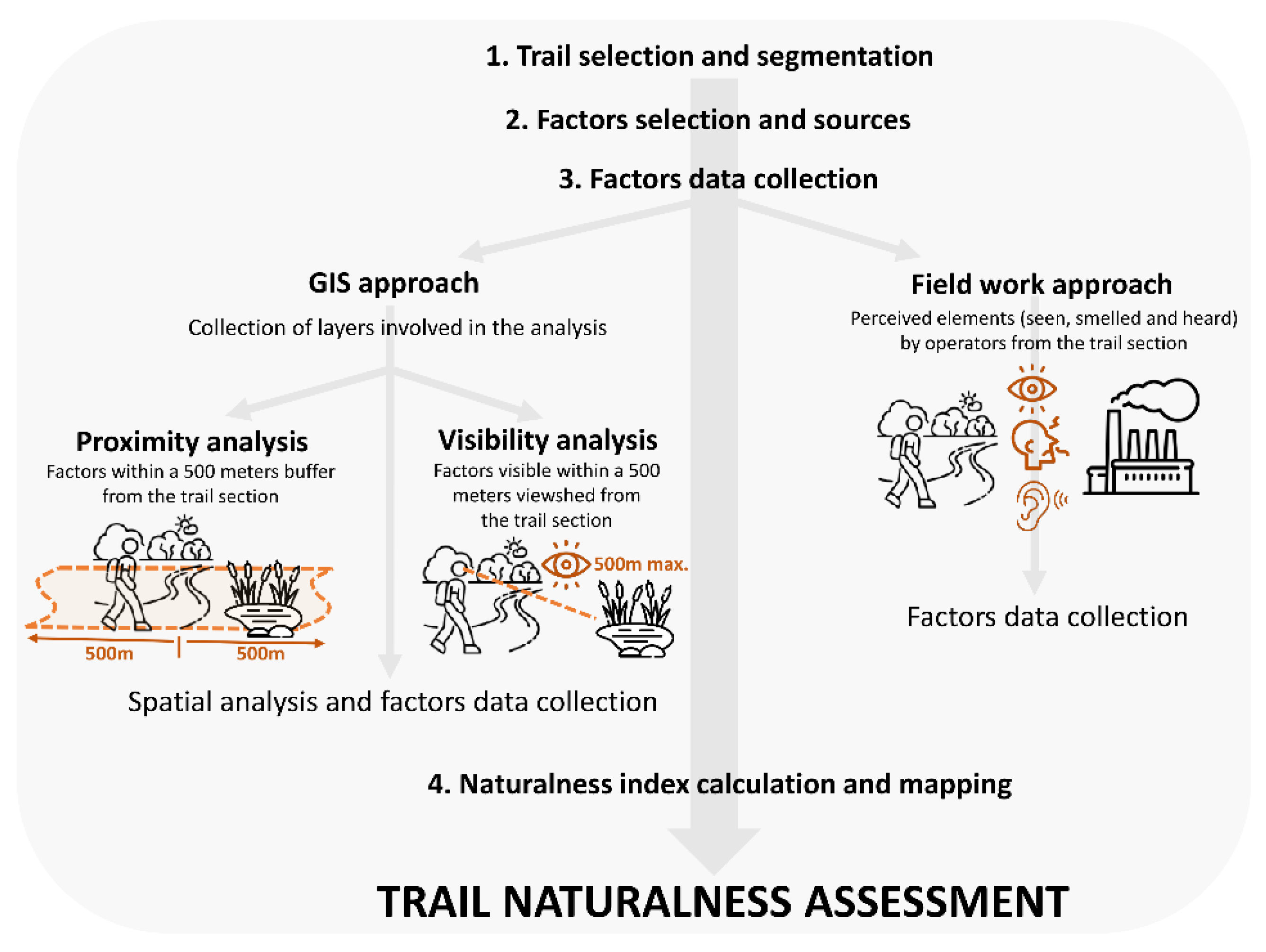
Figure 2.
Study area with the representation of the analysed greenway.
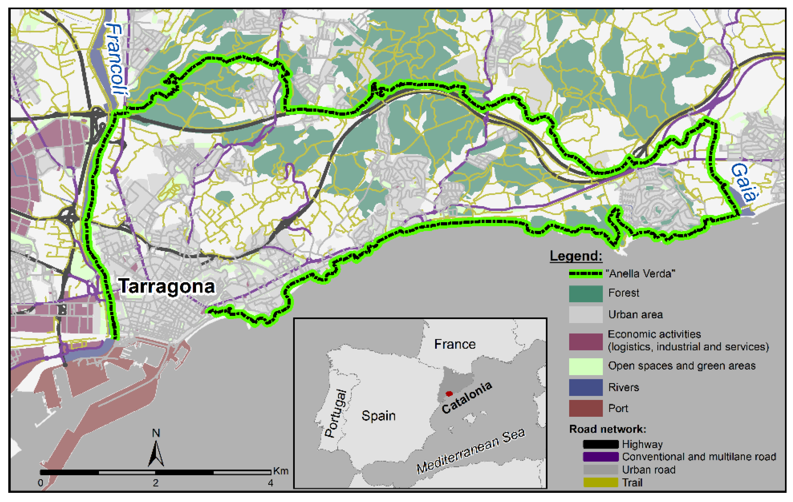
Figure 3.
Mapping of the sections of the greenway along with some representative photographs (own elaboration) of each one.
Figure 3.
Mapping of the sections of the greenway along with some representative photographs (own elaboration) of each one.
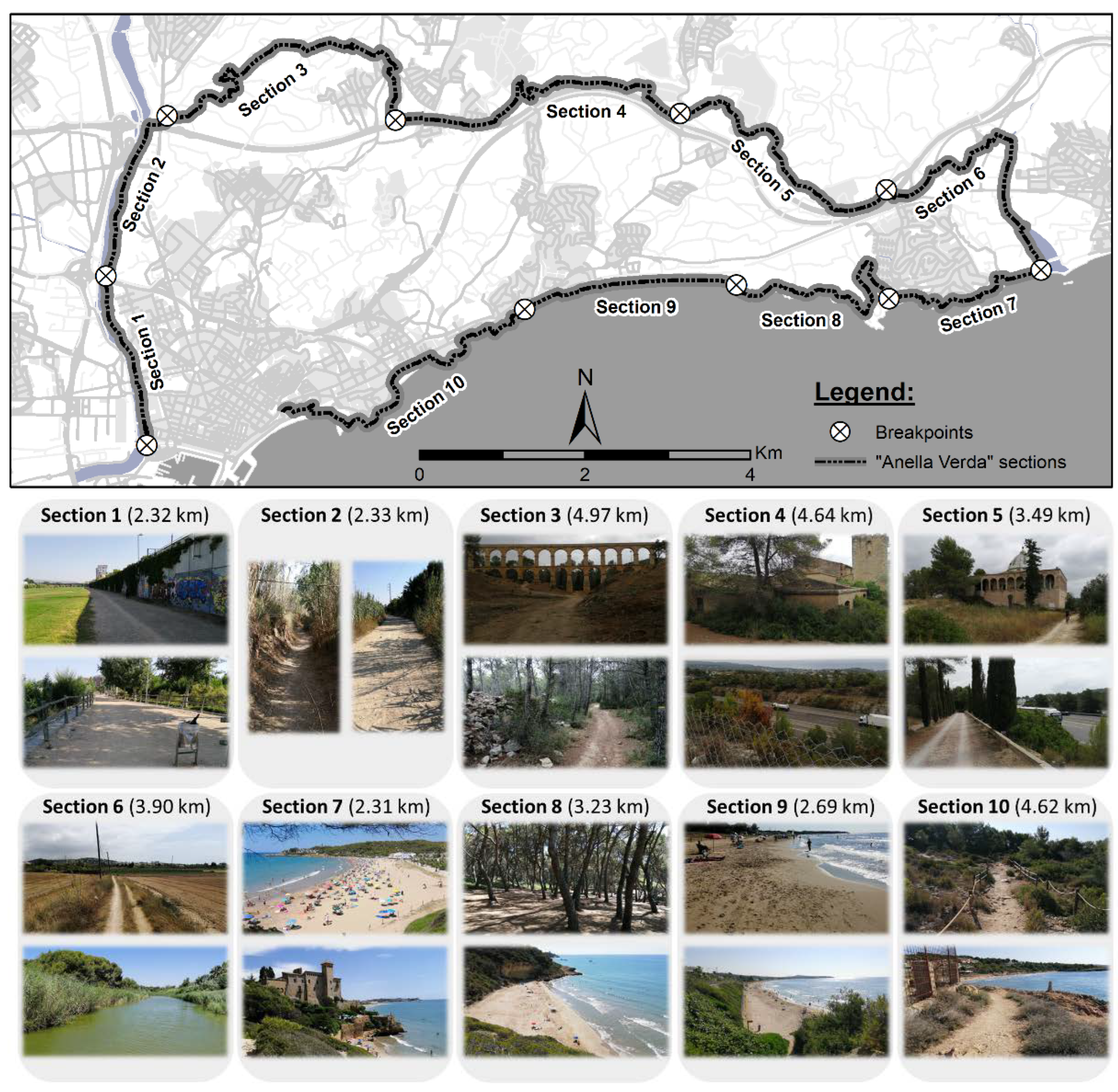
Figure 4.
Mapping of the factors used (a), visual basin (b) and buffer (c) of all sections.
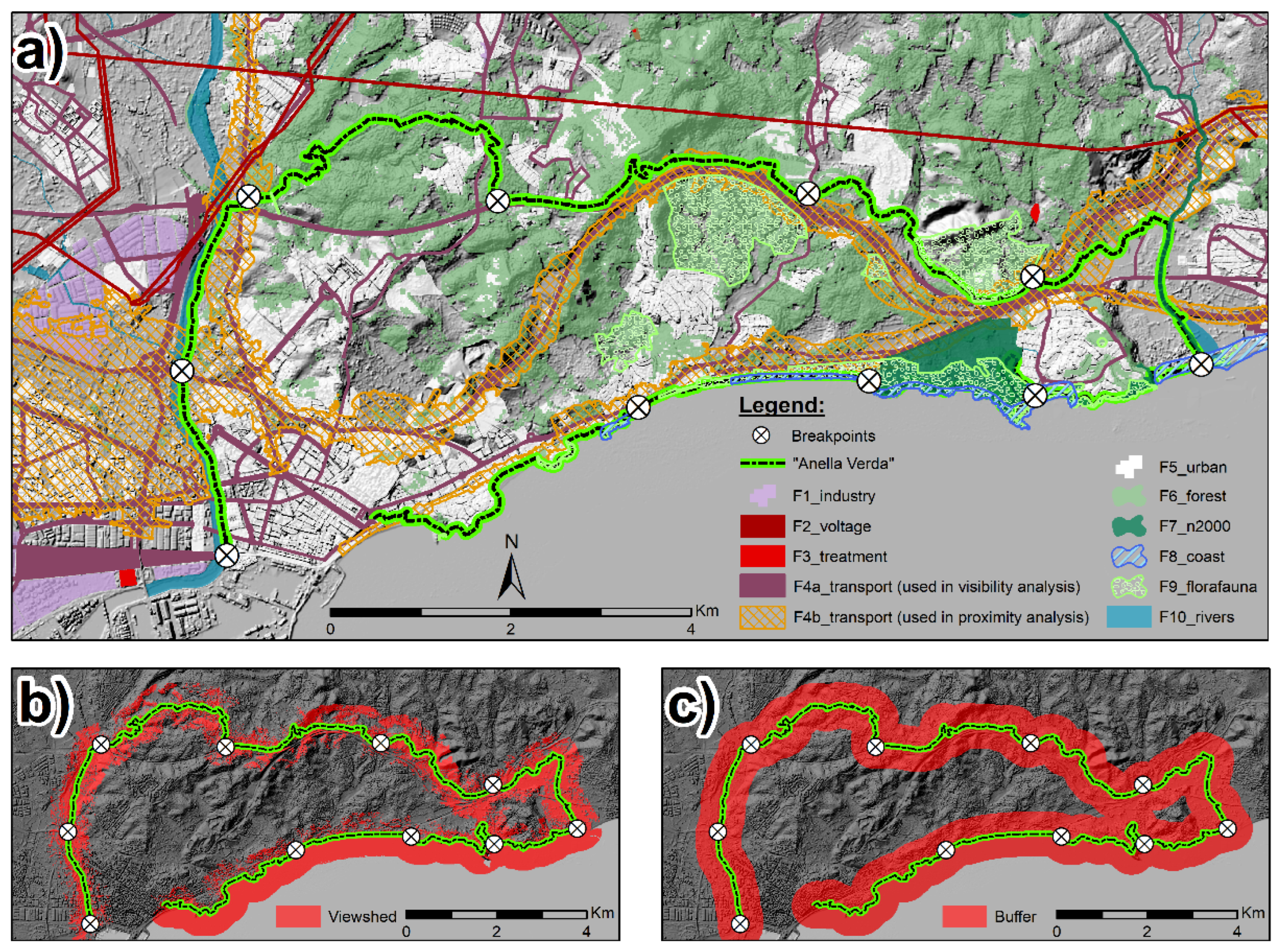
Figure 5.
The naturalness index (NI) obtained for each section (S) according to the three methodological approaches used.
Figure 5.
The naturalness index (NI) obtained for each section (S) according to the three methodological approaches used.
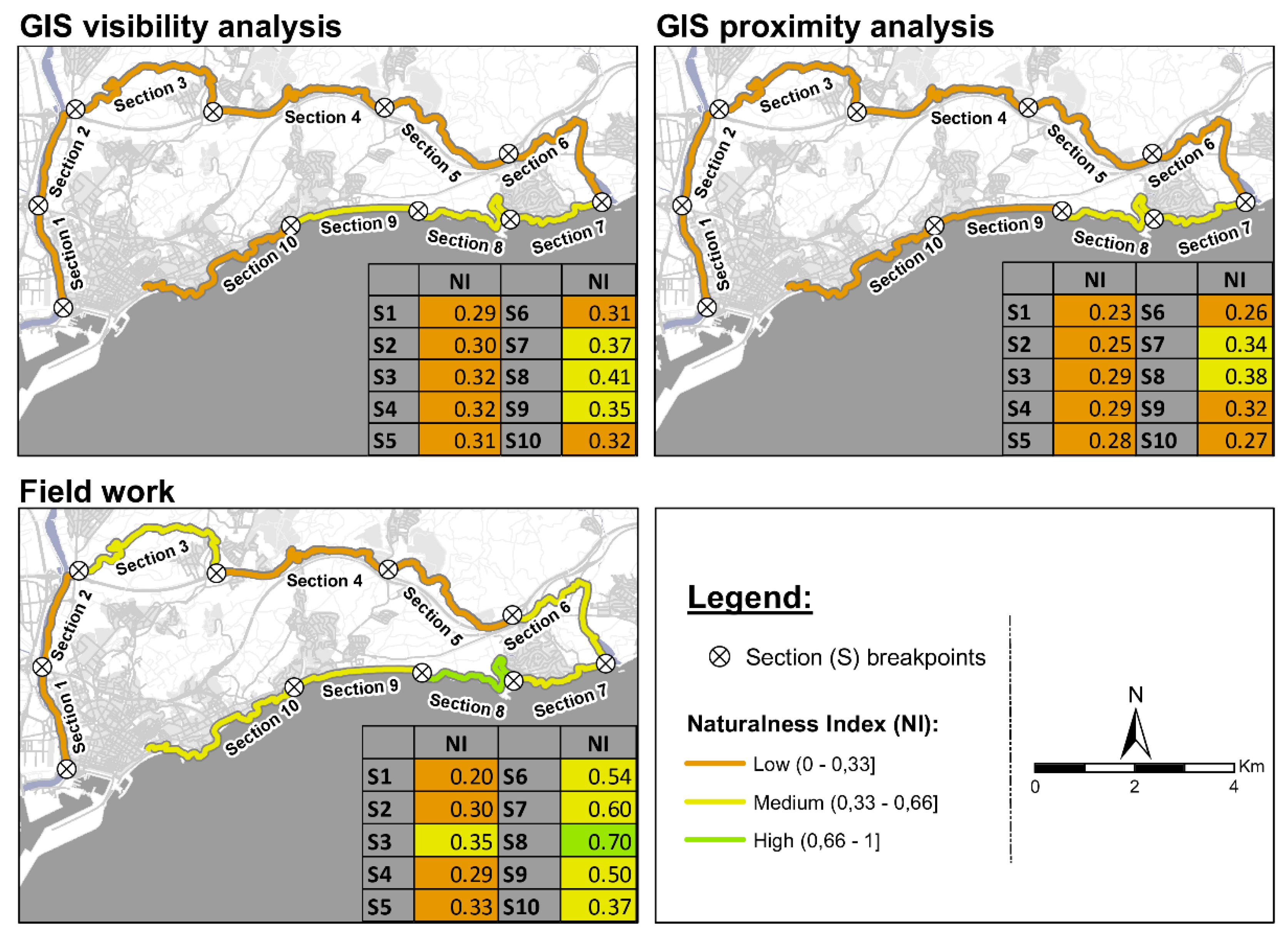
Figure 6.
Coincidence in naturalness class of the sections according to the different methodological approaches used.
Figure 6.
Coincidence in naturalness class of the sections according to the different methodological approaches used.
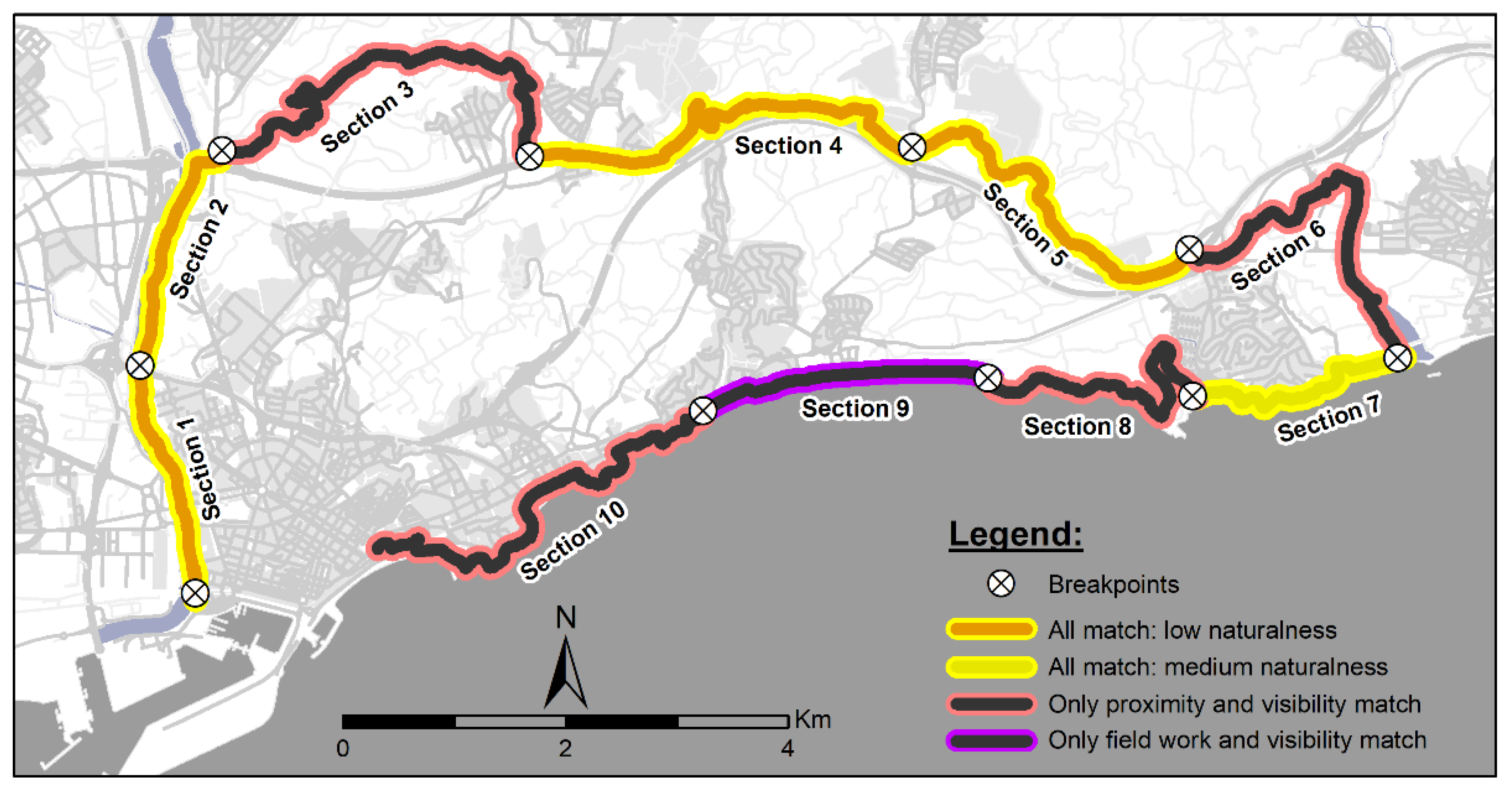

Table 1.
Factors included in the analysis.
| Group | Factors | Description | Source (GIS) |
|---|---|---|---|
| Group 1: intensive use (negative factors) |
F1_industry | Industrial areas | Urbanistic Map of Catalonia (MUC) |
| F2_voltage | High voltage towers and lines | Topographic Map (IGN) | |
| F3_treatment | Water treatment plants | Hypermap (Generalitat de Catalunya) | |
| F4a_transport | Roadways and railways | Urbanistic Map of Catalonia (MUC) | |
| F4b_transport* | Acoustic pollution from roads and railway | Noise Pollution Information System (SICA) | |
| F5_urban | Urban centres | Urbanistic Map of Catalonia (MUC) | |
| Group 2: natural landscapes (positive factors) | F6_forest | Woodland and forest | Hypermap (Generalitat de Catalunya) |
| F7_n2000 | Protected natural areas (Natura 2000 network) | Hypermap (Generalitat de Catalunya) | |
| F8_coast | Scenic coastal landscapes | Landscape catalogue of the Camp de Tarragona (Landscape Observatory of Catalonia) | |
| F9_faunaflora | Areas of faunal and floral interest | Hypermap (Generalitat de Catalunya) | |
| F10_rivers | Water courses (rivers, torrents, etc.) | Urbanistic Map of Catalonia (MUC) | |
| F11_sea | Sea | Hypermap (Generalitat de Catalunya) |
*For the analysis of the transportation factor, with proximity analysis (F4b_transport), the layer indicating the influence area of noise from interurban roads and railway lines has been used (Ldia: Average noise level during the day from 7 a.m. to 7 p.m.).
Table 2.
Number of observation points for each section (S).
| Sections | S1 | S2 | S3 | S4 | S5 | S6 | S7 | S8 | S9 | S10 |
|---|---|---|---|---|---|---|---|---|---|---|
| Number of vertices | 209 | 201 | 790 | 509 | 517 | 444 | 196 | 270 | 144 | 436 |
Table 3.
Comparison of the three analyses used.
| Perceptual fieldwork | GIS visibility | GIS proximity | |
|---|---|---|---|
| Implementation speed | Slow | Moderate | Fast |
| Costs | High and continuous | Medium and initial | Medium and initial |
| Conditioning factors in the selection of factors | Low | High | Medium |
| Risk of variation in the evaluation of the factors | High | Low | Low |
Disclaimer/Publisher’s Note: The statements, opinions and data contained in all publications are solely those of the individual author(s) and contributor(s) and not of MDPI and/or the editor(s). MDPI and/or the editor(s) disclaim responsibility for any injury to people or property resulting from any ideas, methods, instructions or products referred to in the content. |
© 2023 by the authors. Licensee MDPI, Basel, Switzerland. This article is an open access article distributed under the terms and conditions of the Creative Commons Attribution (CC BY) license (http://creativecommons.org/licenses/by/4.0/).
Copyright: This open access article is published under a Creative Commons CC BY 4.0 license, which permit the free download, distribution, and reuse, provided that the author and preprint are cited in any reuse.


