
Submitted:
14 March 2022
Posted:
17 March 2022
You are already at the latest version
Abstract
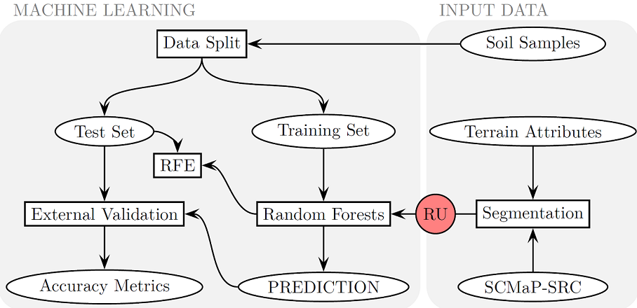
There is a growing need for an area-wide knowledge of SOC contents in agricultural soils at field scale for food security, monitoring long-term changes related to soil health and climate change. In Germany, large-scale SOC maps are mostly available with a spatial resolution of 250 m to 1 km2. The nationwide availability of both digital elevation models at various spatial resolutions and multi-temporal satellite imagery enables the derivation of multi-scale terrain attributes and Landsat-based multi-temporal soil reflectance composites (SRC) as explanatory variables. On the example of an Bavarian test of about 8000 km2, the scale-specific dependencies between the representativeness of 220 soil samples and different aggregation levels of the explanatory variables were analyzed for their scale-specific predictive power. The aggregation levels were generated by applying a region-growing segmentation procedure, the SOC content prediction was realized by the Random Forest algorithm. In doing so, established approaches of (geographic) object-based image analysis (GEOBIA) and machine learning were combined. The modeling results revealed scale-specific differences. Compared to terrain attributes, the use of SRC parameters lead to a significant model improvement at large field-related scale levels. The joint use of both terrain attributes and SRC parameters resulted in further model improvements. The best modeling variant is characterized by an accuracy of R2=0.84 and RMSE=1.99.
Keywords:
soil reflectance composites
; digital soil modeling
; soil organic carbon
; GEOBIA
; Landsat
; terrain analysis
Copyright: This open access article is published under a Creative Commons CC BY 4.0 license, which permit the free download, distribution, and reuse, provided that the author and preprint are cited in any reuse.


