Submitted:
14 December 2020
Posted:
15 December 2020
Read the latest preprint version here
Abstract
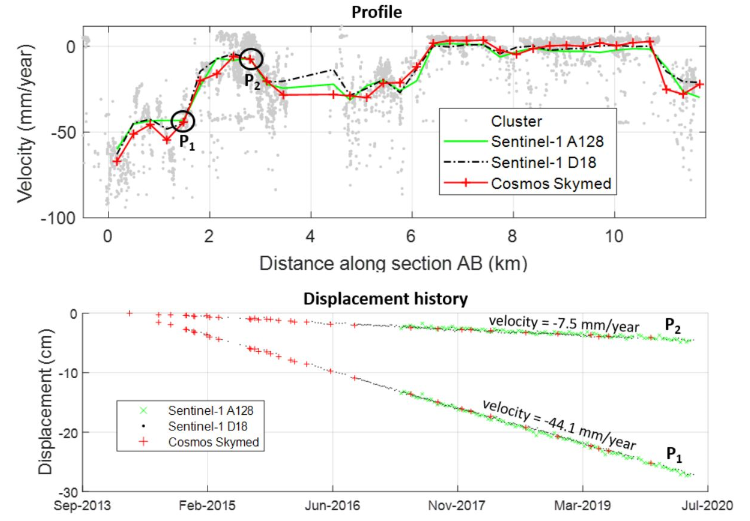
Ho Chi Minh City (HCMC), the most populous city and the economic center of Viet Nam, has faced ground subsidence in recent decades. This work aims at providing an unprecedented spatial extent coverage of the subsidence in HCMC in both horizontal and vertical components using Interferometric Synthetic Aperture Radar (InSAR) time series. For this purpose, an advanced InSAR technique PSDS (Permanent Scatterers and Distributed Scatterers) was applied to two big European Space Agency (ESA) Sentinel-1 datasets composed of 96 ascending and 202 descending images, acquired from 2014 to 2020 over HCMC area. A time series of 33 Cosmos SkyMED images was also used for comparison purpose. The combination of ascending and descending satellite passes allows the decomposition of the light of sight velocities into horizontal East-west and vertical components. By taking into account the presence of the horizontal East-west movement, our finding indicates that the precision of the decomposed vertical velocity can be improved up to 3 mm/year for Sentinel-1 data. The obtained results revealed that subsidence is most severe in areas along the Sai Gon river in the northwest-southeast axis and the southwest of the city with the maximum value up to 80 mm/year, consistent with findings in the literature. The magnitude of horizontal East-West velocities is relatively small and a large-scale westward motion can be observed in the northwest of the city at a rate of 2-5 mm/year. Together, these results reinforced the remarkable suitability of ESA's Sentinel-1 SAR for subsidence applications even for non-Europe countries such as Vietnam and Southeast Asia.
Keywords:
Horizontal East-west velocity
; LOS
; vertical velocity
; InSAR time series
; Big Data
; PSDS
; TomoSAR platform
; Sentinel-1
; Ho Chi Minh City
Copyright: This open access article is published under a Creative Commons CC BY 4.0 license, which permit the free download, distribution, and reuse, provided that the author and preprint are cited in any reuse.


