Submitted:
23 August 2019
Posted:
26 August 2019
You are already at the latest version
Abstract
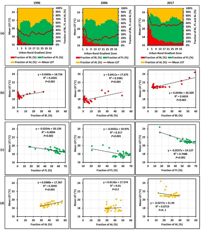
Although urbanization has contributed to improving living conditions, it has had negative impacts on the natural environment in the urbanized areas. Urbanization has changed the urban landscape and resulted in increasing land surface temperature (LST). Thus, studies related to LST in various urban environments have become a popular research topic. However, few LST studies focusing on the mountain landscapes (i.e. hill stations) have been carried out. The primary objective of this study is to investigate changes in the landscape and their impacts on LST intensity (LSTI) in the tropical mountain city of Nuwara Eliya, Sri Lanka. The study utilized annual median temperatures extracted from Landsat data collected from 1996 to 2017 based on the Google Earth Engine (GEE) interface. The fractions of built-up (BL), forest (FL), and agricultural (AL) land were calculated using land use and cover maps based on the urban-rural zone (URZ) analysis. The urban-rural margin was demarcated based on the fraction of BL (<10%) and LSTI was measured using the mean LST difference in the urban-rural zone. In addition, the mixture of land use types was calculated using the AL/FL and BL/FL fraction ratios, and grid-based density analysis. The result shows that the BL in all URZ rapidly developed, while AL decreased during the period 1996 to 2017. There was minimal change in the forest area of the Nuwara Eliya owing to the government forest preservation policies. The fraction of the BL increased from 32.4% in 1996 to 58.7% in 2017 in the city center zone (URZ1) resulting in increased mean LST by 4.7 °C. Furthermore, the increase of the BL/FL fraction ratio and the decrease of the AL/FL fraction ratio were positively correlated with the mean LST. Grid-based analysis showed an increasing positive relationship between mean LST and density of BL. This indicated that BL density has been a crucial element in increasing LST in the study area. The results of this study will be a useful indicator to introduce improved landscape and urban planning in the future to minimize the negative impact of LST on urban sustainability.
Keywords:
land use and cover
; land surface temperature
; built-up land
; agricultural land
; gradient analysis
; Nuwara Eliya
; Sri Lanka
Copyright: This open access article is published under a Creative Commons CC BY 4.0 license, which permit the free download, distribution, and reuse, provided that the author and preprint are cited in any reuse.


