
Submitted:
27 December 2018
Posted:
31 December 2018
You are already at the latest version
Abstract
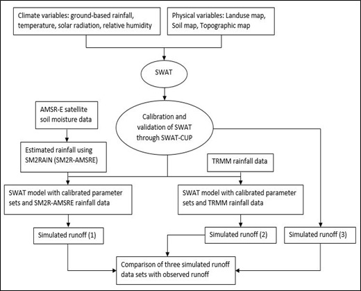
Hydrological models have been widely used for many purposes in water sector projects, including streamflow prediction and flood risk assessment. Among the input data used in such hydrological models, the spatial-temporal variability of rainfall datasets has a significant role on the final discharge estimation. Therefore, accurate measurements of rainfall are vital. On the other hand, ground-based measurement networks, mainly in developing countries, are either nonexistent or too sparse to capture rainfall accurately. In addition to in-situ rainfall datasets, satellite-derived rainfall products are nowadays available globally with high spatial and temporal resolution. An innovative approach called SM2RAIN that estimates rainfall from soil moisture data has been applied successfully to various regions. In this study, firstly soil moisture content derived from the Advanced Microwave Scanning Radiometer for the Earth observing system (AMSR-E) is used as input into the SM2RAIN algorithm to estimate daily rainfall, SM2R-AMSRE, at different sites in the Karkheh river basin (KRB), southwest Iran. Secondly, the SWAT (Soil and Water Assessment Tool) hydrological model is applied to simulate runoff using both ground-based observed rainfall and SM2R-AMSRE rainfall as input. The results reveal that the SM2R-AMSRE rainfall data are, in most cases, in good agreement with ground-based rainfall, with correlations R ranging between 0.58 and 0.88, though there is some underestimation of the observed rainfall, due to soil moisture saturation, not accounted for in the SM2RAIN equation. The subsequent SM2R-AMSRE- SWAT- simulated monthly runoff reproduces well the observations at the 6 gauging stations (with coefficient of determination, R² > 0.72), though with slightly worse performances in terms of bias (Bias) and root-mean-square error (RMSE) and, again, some systematic flow underestimation than the SWAT model with ground-based rainfall input. Furthermore, rainfall estimations of two satellite products of the Tropical Rainfall Measuring Mission (TRMM), 3B42 and 3B42RT, are used in the calibrated SWAT- model. The monthly runoff obtained with 3B42- rainfall have 0.39< R2 < 0.70 and are slightly better than those obtained with 3B42RT- rainfall, but not as good as the SM2R-AMSRE- SWAT- simulated runoff above. Therefore, in spite of the afore-mentioned limitations, using SM2R-AMSRE rainfall data in a hydrological model like SWAT, appears to be a viable approach in basins with limited ground-based rainfall data.
Keywords:
AMSR-E
; soil moisture product
; SM2RAIN
; SWAT hydrological model
; Karkheh river basin
Copyright: This open access article is published under a Creative Commons CC BY 4.0 license, which permit the free download, distribution, and reuse, provided that the author and preprint are cited in any reuse.


