
Submitted:
05 August 2016
Posted:
06 August 2016
You are already at the latest version
Abstract
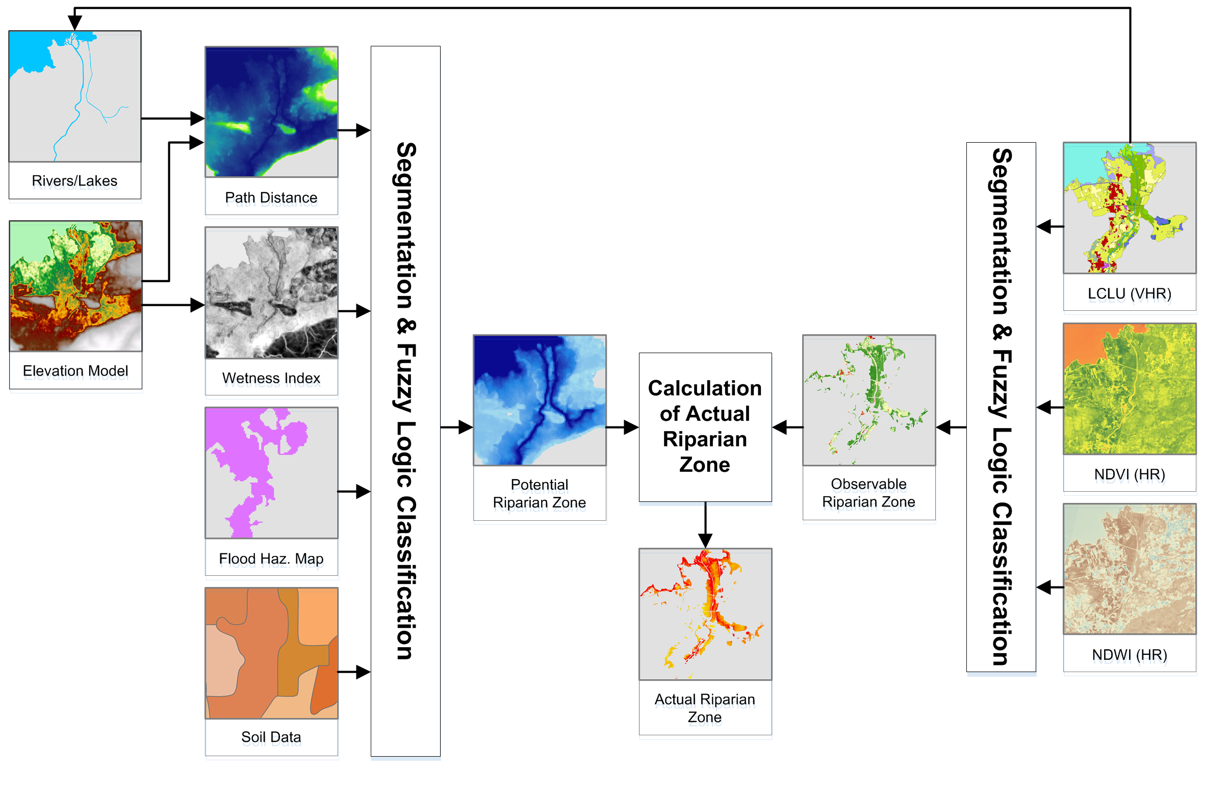
Riparian zones represent ecotones between terrestrial and aquatic ecosystems and are of utmost importance to biodiversity and ecosystem functions. Modelling/mapping of these valuable and fragile areas is needed for an improved ecosystem management, based on an accounting of changes and on monitoring of their functioning in time. In Europe, the main legislative driver behind this goal is the European Commission’s Biodiversity Strategy to 2020, on one hand aiming at reducing biodiversity loss, on the other hand enhancing ecosystem services by 2020, and restoring them as far as feasible. A model, based on Earth Observation data, including Digital Elevation Models, hydrological, soil, land cover/land use data, and vegetation indices is employed in a multi-modular and stratified approach, based on fuzzy logic and object based image analysis, to delineate potential, observed and actual riparian zones. The approach is designed in an open modular way, allowing future modifications and repeatability. The results represent a first step of a future monitoring and assessment campaign for European riparian zones and their implications on biodiversity and on ecosystem functions and services. Considering the complexity and the enormous extent of the area, covering 39 European countries, including Turkey, the level of detail is unprecedented. Depending on the accounting modus, 0.95%–1.19% of the study area can be attributed as actual riparian area (considering Strahler’s stream orders 3-8, based on the Copernicus EU-Hydro dataset), corresponding to 55,558–69.128 km2. Similarly depending on the accounting approach, the potential riparian zones are accounted for about 3-5 times larger. Land cover/land use in detected riparian areas was mainly of semi-natural characteristics, while the potential riparian areas are predominately covered by agriculture, followed by semi-natural and urban areas.
Keywords:
riparian zone
; transitional environment
; riparian forest buffer
; spatial modelling
; mapping
; spatial ecology
; ecosystem functions
Copyright: This open access article is published under a Creative Commons CC BY 4.0 license, which permit the free download, distribution, and reuse, provided that the author and preprint are cited in any reuse.


