

Submitted:
24 August 2026
Posted:
25 August 2026
You are already at the latest version
Abstract
Deploying macro-scale Digital Twins (DT) in the AECOO sector requires bridging micro-level engineering precision (BIM) with macro-scale geospatial dynamics (GIS). This review investigates the technological evolution of GeoBIM integration as a foundation for macro-scale DTs based on 2024–2026 developments. Evaluating the idealized paradigm of fully bidirectional DTs, the paper categorizes digital maturity levels (Digital Models, Digital Shadows, and true Digital Twins) across major infrastructure cases, including smartBRIDGE Hamburg, the M-30 Highway, the Zurich City Twin, and Virtual Singapore. Furthermore, university campuses are evaluated as multi-scale urban living labs. An empirical case study of the 72-hectare Warsaw University of Life Sciences (SGGW) campus demonstrates how integrating GIS spatial analyses with parametric BIM models enables diagnostic accessibility modeling, universal design, and urban resilience planning for vulnerable populations. To overcome cross-lifecycle data fragmentation, the DOLCE-grounded BIM-Phase ontology is highlighted for preserving physical element identity across temporal states via OWL 2 DL. Finally, the study outlines technical barriers and development trajectories toward Cognitive Digital Twins (CDT) augmented with Artificial Intelligence and Large Language Models.
Keywords:
GeoBIM
; digital twin
; BIM
; GIS
; BIM-Phase ontology
; asset management
; cognitive digital twin
; AI
; urban planning
; accessibility modeling
1. Introduction
The Architecture, Engineering, Construction, Owner, and Operator (AECOO) sector is undergoing a dynamic digital transformation. Traditional, static methods of documentation and information management are giving way to dynamic, integrated database environments [1]. In this context, the concept of the Digital Twin (DT) has risen to the status of a idealized paradigm in modern engineering and construction digitization. It promises the creation of a living, continuously updated real-time virtual representation of physical assets, capable of autonomously controlling operational processes, optimizing energy consumption, and predicting structural failures before they occur.
The development of the Digital Twin paradigm in the AECOO sector is closely linked to the evolution of knowledge management systems and artificial intelligence algorithms. Although revolutionary during the design and construction phases, traditional BIM models exhibit the characteristics of static data repositories, representing a building as a snapshot of its state at a given moment. The technological breakthrough of 2024–2026 defined a new class of solutions: Cognitive Digital Twins (CDT), which extend classic DT architecture with a layer of semantic reasoning, machine learning, and interfaces based on Large Language Models (LLMs). The implementation of CDTs enables the automatic interpretation of unstructured sensor data, the identification of structural anomalies using neural networks (e.g., Transformer and LSTM architectures), and the generation of predictive decision scenarios for infrastructure managers without requiring manual expert analysis. However, a key challenge in this domain remains the construction of unified Knowledge Graphs capable of merging heterogeneous data streams originating from building automation systems, Internet of Things (IoT) sensors, and macro-scale GIS databases.
Despite the widespread presence of this term in both marketing and scientific discourse, the actual implementation of complete, bidirectional, and autonomous digital twins in construction still faces severe barriers. Most existing systems worldwide declared as digital twins actually represent a lower level of digital maturity—they are so-called Digital Shadows. This stems from the fact that the flow of information in these systems typically occurs unidirectionally: from sensors embedded on the physical asset to the virtual model, without the capability for a feedback, automated control action from the model back onto the physical structure.
Deploying digital twins on a macro scale (encompassing entire cities, transport corridors, or river systems) requires the integration of data with dual characteristics. On the one hand, micro-scale geometric and engineering precision concerning specific built structures is indispensable, which is the domain of Building Information Modeling/Management (BIM). On the other hand, it is necessary to embed this data within the broader macro-scale context of the spatial, natural, legal, and social environment, which is realized by Geographic Information Systems (GIS) [2]. The combination of these two distinct technological domains is referred to as GeoBIM. This integration constitutes the foundation without which the construction of dynamic, macro-scale twin models is impossible.
2. Materials and Methods
The deployment of macro-scale Digital Twins in infrastructure and civil engineering faces severe technical, organizational, and semantic bottlenecks [3,4]. Although the concept promises autonomous, real-time control loops, real-world implementations struggle to bridge the gap between static building documentation and dynamic urban-scale data processing [3,5].
A primary problem lies in data fragmentation across the asset lifecycle. During the transition from design to operation, up to 30% of critical engineering context is lost due to incompatible software formats and missing semantic relationships [6,7]. Standard Building Information Modeling (BIM) schemas, such as Industry Foundation Classes (IFC), are optimized for micro-scale geometric representations of single facilities [8]. However, when scaled to regional networks or smart cities, IFC schemas generate excessive computational overhead and lack direct compatibility with Geographic Information Systems (GIS) operating on global cartographic projections [7,9].
Furthermore, integrating continuous real-time IoT sensor streams into spatial environments presents major architectural challenges [4,5,10,11]. Traditional relational databases are ill-equipped to handle high-frequency time-series data while maintaining dynamic topology links with 3D physical elements [5,12]. As highlighted by recent studies in system innovation and smart infrastructure [13,14], achieving true bidirectional interaction (Level 3 DT) requires resolving severe latency issues in cloud-edge computing pipelines and mitigating cybersecurity vulnerabilities in automated control networks [3,10]. Without formal semantic frameworks capable of unifying spatial micro-details, macro-environments, and temporal events, most infrastructure representations remain constrained to passive Digital Shadows [6,12].
In order to investigate development trends and reliably verify the state of Digital Twin technology implementation worldwide, a systematic literature review covering the period 2024–2026 was conducted in this study. The analysis encompassed leading international databases, including Google Scholar, ResearchGate, and Web of Science. During the source selection process, particular attention was paid to publications characterized by high recency and representativeness regarding the examined issues. A key point of reference was the research work of Prof. Andrzej Szymon Borkowski from Warsaw University of Technology, whose holistic approach to BIM implementation, BIM–GIS interoperability, and ontological modeling constitutes a significant contribution to the development of national and international engineering thought. The research process employed methods of source criticism, abstraction, and conceptual analysis, enabling the formulation of conclusions that extend beyond a simple synthesis of literature data.
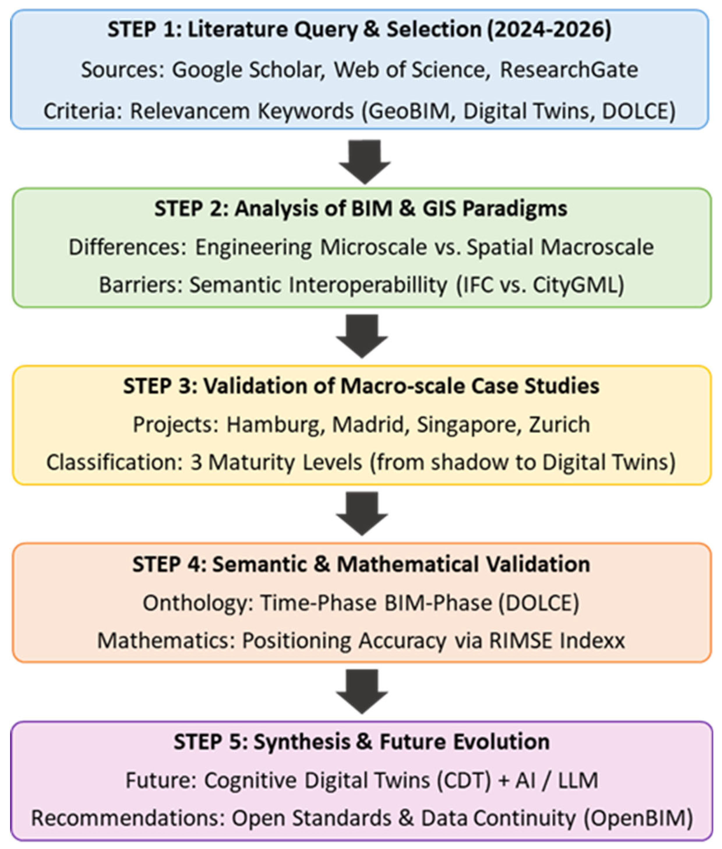
Figure 1.
Research methodology of the article.
Although crucial, the integration of BIM and GIS technologies involves profound paradigmatic discrepancies, which have been described in detail in the works of Gabriela Buniewicz and Andrzej Szymon Borkowski. The fundamental differences between BIM and GIS systems are summarized in Table 1.
The profound paradigmatic discrepancies between BIM and GIS, illustrated in Table 1, stem from the differing origins of both technologies. A significant milestone in addressing these challenges was the official approval and implementation of the IFC 4.3 standard by buildingSMART International in 2024, which introduced native support for linear infrastructure assets such as roads, railways, bridges, and ports. Despite this extension, the semantic and syntactic translation of data from the IFC format to OGC standards (such as CityGML or CityJSON) still encounters barriers related to the loss of engineering detail in favor of computational efficiency at the macro scale. This process requires advanced semantic mapping techniques at the XSD schema level as well as geometric transformations, which frequently lead to the degradation of geometric and semantic information during file conversion. An additional complication is the incompatibility of Coordinate Reference Systems (CRS). While BIM models operate on local, orthogonal Cartesian coordinate systems oriented toward a specific project origin point, GIS systems require projecting this data onto global geodetic ellipsoids (e.g., the WGS84 system or national projection systems), which, in the absence of precise georeferencing metadata, generates spatial displacement errors.
As indicated by Buniewicz and Borkowski, the execution of modern construction projects requires a consistent flow of information at every stage of the project lifecycle. One of the most serious technical problems is the correct georeferencing of BIM models within a GIS environment. The Industry Foundation Classes (IFC) standard lacks a fully unified and straightforward mechanism for the automatic mapping of local coordinates to global cartographic reference systems, necessitating the application of advanced transformation algorithms (e.g., the seven-parameter Helmert transformation method) [15].
Experiments conducted by Borkowski and To Duc using Feature Manipulation Engine (FME) software for the conversion and georeferencing of a historical building at Plac Konstytucji in Warsaw demonstrated that while it is possible to precisely embed a BIM model within the GIS geographic coordinate space, the 3D geometry itself loses detail during semantic translation. Converting models from engineering formats to GIS formats (e.g., shapefile) frequently leads to the degradation of geometric and semantic information, which hampers subsequent macro-scale spatial analyses [16].
2.1. Digital Twin in the Light of Facts: Between Shadow and Reality
To precisely answer the question of whether Digital Twin is merely a marketing myth or an existing engineering fact, it is necessary to analyze the maturity classification of digital models presented in Table 2.
An analysis of implementations from 2024–2026 confirms that the majority of systems operating in the construction and infrastructure sectors are, in fact, Digital Shadows. This stems from the fact that built structures possess passive structural characteristics. While in manufacturing plants a robotic arm can be automatically repositioned by a digital twin algorithm, in the case of a bridge or a road, an automated alteration of geometry or physical parameters (e.g., cable prestressing) without human intervention is technically complex or virtually impossible.
However, spectacular macro-scale engineering projects exist worldwide that closely approach the full definition of a Digital Twin by realizing advanced analytical-decision and visualization loops:
- smartBRIDGE Hamburg (Germany): This project encompasses the Köhlbrand Bridge in the Port of Hamburg. A network of over 500 sensors was installed on the structure to monitor its technical condition in real time, including stresses, vibration accelerations, and temperature. These data are dynamically mapped onto a 3D model, enabling an immediate assessment of load-bearing capacity and the planning of predictive maintenance, thereby minimizing the risk of failure and the need for in-person field inspections [17].
- M-30 Highway in Madrid (Spain): A case study described by Jerez Cepa and García Alberti focuses on Madrid’s urban ring road, spanning a total length of over 200 km, with 48 km passing through tunnels. Managing such a complex network asset (over 84 bridges, 200 emergency exits, 900 ventilation fans, and 100,000 meters of firefighting pipelines) was achieved by integrating distributed GIS inventories and point clouds with detailed BIM models at a Level of Detail of LOD 300. The entire ecosystem was linked to an external relational database via unique identifiers, allowing the tracking of over 400 Key Performance Indicators (KPIs) in real time, which yielded tangible economic benefits during the operational phase [18].
- Virtual Singapore: A flagship implementation on a nation-state scale. The Land Transport Authority deployed over 100,000 IoT sensors, creating a dynamic urban model. The application of hybrid LSTM-Transformer artificial intelligence models enabled traffic volume predictions 15 minutes in advance (forecasting error < 8%), reducing the response time of emergency and public services to 90 seconds [19].
- Zurich City Twin (Switzerland): An implementation based on Esri’s ArcGIS GeoBIM platform. It merges lightweight geometric representations of Revit and IFC models with dynamic streaming layers from temperature and motion sensors in buildings. This model served advanced flood simulations for the Sihl River, building carbon footprint evaluations, and urban heat island analyses [20].
An in-depth technical analysis of the smartBRIDGE Hamburg project highlights the deployment of an IoT sensor network dynamically mapped onto the 3D structural model of the Köhlbrand Bridge. Accelerometric and piezoelectric sensors installed on the structure transmit continuous signals monitoring its technical condition—including stresses, vibration accelerations, and temperature—enabling instantaneous load-capacity evaluation. Any deviation from the nominal model (the so-called structural “health signature”) can be automatically identified by integrated diagnostic systems. Via API mechanisms, these data are integrated with external relational databases and Computerized Maintenance Management Systems (CMMS), allowing for predictive maintenance planning and the mitigation of structural failure risks. Conversely, the case of the M-30 highway in Madrid demonstrates that integrating distributed GIS inventories and point clouds with detailed BIM models at LOD 300 enables efficient management of complex network assets comprising bridges, tunnels, and ventilation systems. Linking these data via unique identifiers to facility management databases enables real-time tracking of over 400 KPIs, generating measurable economic benefits in the operational phase [18,21,22].
A summary of the key parameters of the examined macro-scale implementations is presented in Table 3.
In the evolution from static BIM models to dynamic Digital Twins, research on data structure and information semantics plays a crucial role. In a 2024 publication titled “Digital twin conceptual framework for the operation and maintenance phase in the building’s lifecycle”[23], Borkowski proposed an original conceptual framework for the operation and maintenance (O&M) phase of building structures. He highlighted that the construction industry permanently struggles with data loss during the handover of facilities from the construction phase to the operational phase. The proposed solution relies on BIM methodology as a foundation that is “activated” through integration with IoT sensor networks and artificial intelligence algorithms. This framework enables the transformation of facility management from a reactive model (repair after failure) to a proactive and predictive model. Furthermore, the author demonstrated that, with appropriate modifications, this framework can be successfully scaled to infrastructure assets or entire urban fragments at a macro scale.
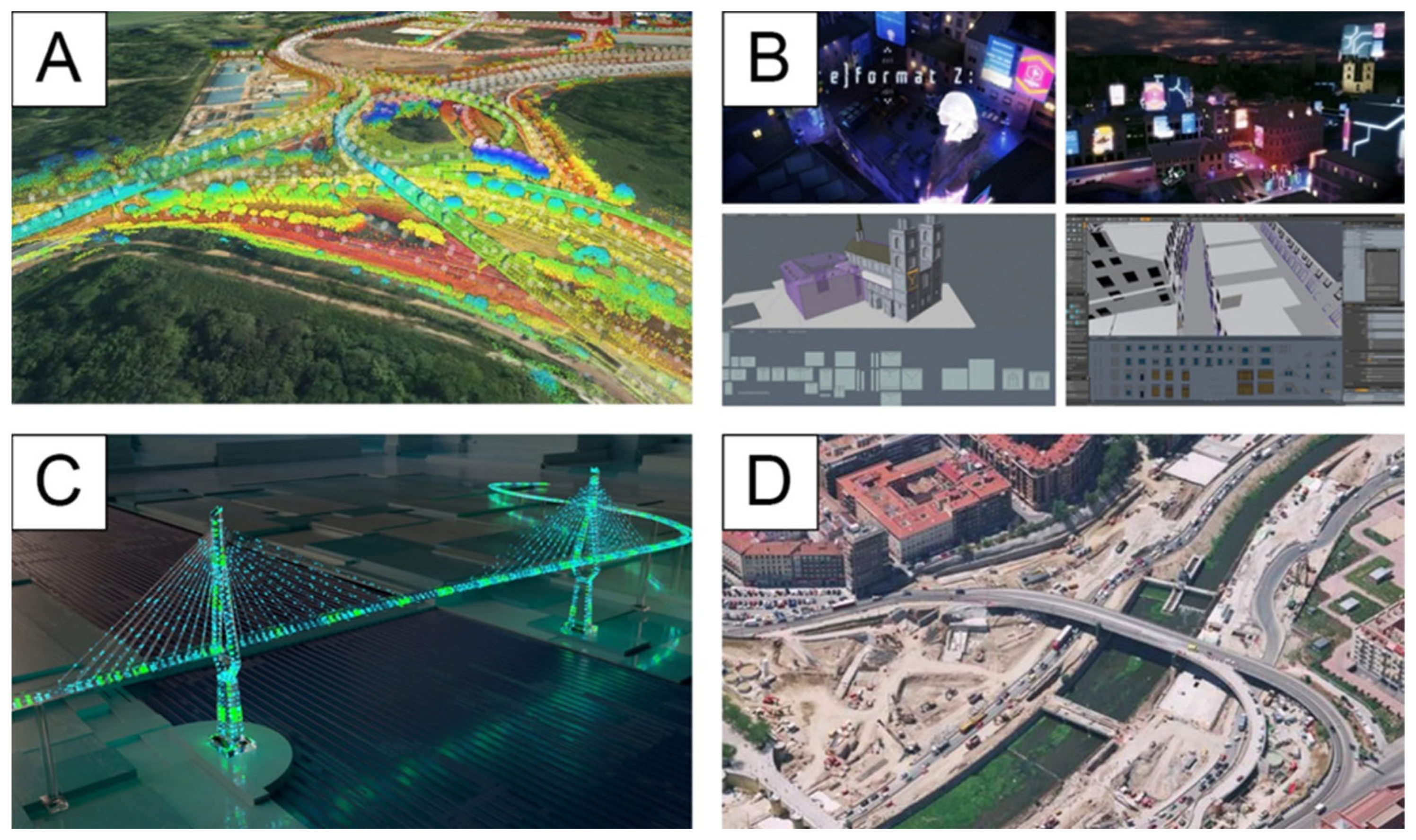
Figure 2.
Discussed macro-scale implementations.Source: A (Virtual Singapore)—https://www.geoweeknews.com/news/singapore-land-authority-digital-twin-bentley-systems-3d-mapping; B (Zurich City Twin)—https://link.springer.com/article/10.1007/s41064-020-00092-2; C (SmartBRIDGE Hamburg)—https://sustainableworldports.org/project/hamburg-port-authority-smartbridge/; D (M-30 Madrid Highway)—https://www.elconfidencial.com/alma-corazon-vida/2020-09-14/origenes-de-la-m30-curiosidades-autopista-salvo-madrid_2739516/.
Figure 2.
Discussed macro-scale implementations.Source: A (Virtual Singapore)—https://www.geoweeknews.com/news/singapore-land-authority-digital-twin-bentley-systems-3d-mapping; B (Zurich City Twin)—https://link.springer.com/article/10.1007/s41064-020-00092-2; C (SmartBRIDGE Hamburg)—https://sustainableworldports.org/project/hamburg-port-authority-smartbridge/; D (M-30 Madrid Highway)—https://www.elconfidencial.com/alma-corazon-vida/2020-09-14/origenes-de-la-m30-curiosidades-autopista-salvo-madrid_2739516/.
Utilizing academic campus areas as testing grounds (living labs) for GeoBIM and Digital Twin technologies demonstrates a direct link to urban planning in times of crisis. Campuses represent unique “urban microcosmos”—characterized by a compact, multifunctional spatial structure, high population density, a building stock of diverse historical ages, and dedicated technical infrastructure. A unified ownership structure and full access to management data enable the safe testing of spatial digital models before scaling them to entire metropolises. In the context of contemporary crises—climatic, energy, or sanitary—the integration of the architectural scale (BIM) with the geospatial scale (GIS) becomes a critical tool supporting urban resilience.
Amid the climate crisis, environmental hazards, and the necessity for energy transition, higher education campuses are no longer analyzed as isolated architectural islands, but rather as complex urban ecosystems with high user density that reflect the challenges of the city’s mesostructural scale. Applying the integration of GIS spatial data with parametric BIM building models enables the analysis of interactions occurring at the intersection of building volumes and the urban fabric, serving as a vital planning tool in the face of rapid socio-economic and environmental shifts.
Implementations across large-scale campuses demonstrate how multi-criteria spatial modeling supports crisis management and sustainable urban development at the spatial planning level. In the NTU EcoCampus project in Singapore, multi-scale microclimate and energy simulations conducted across an area encompassing over 200 buildings proved that digital modeling of spatial relationships enables reductions in energy consumption and carbon emissions district-wide, setting new standards for climate change adaptation [24].
In turn, experiences from Politecnico di Milano highlight the essential role of integrating HBIM and GIS systems in safeguarding the historical urban fabric and preserving the functional continuity of architectural heritage in the face of contemporary anthropogenic pressures [25]. In the context of safety crises and mass evacuation, research conducted at the University of Turin (UniTo) demonstrated the application of GeoBIM platforms and crowd simulation to enhance urban resilience and efficiently manage fire hazard scenarios across a campus with a dispersed urban structure [26].
This approach is complemented by work from Mansoura University, where three-dimensional 3D-GIS modeling using tools such as Esri CityEngine serves evidence-based urban decision-making, enabling dynamic management of traffic, public space organization, and technical infrastructure modifications during operational disruptions [27]. The convergence of these methodologies is further corroborated by the outcomes of the international EuroSDR project, which defined guidelines for mapping and planning authorities regarding the seamless integration of IFC and CityGML standards to enhance urban management quality [28].
A project carried out by the student architectural science club “Archi-Eco-Lab” between 2025 and 2026 at the Warsaw University of Life Sciences (SGGW). The aim of the student project under supervision of authors was to investigate the potential of integrating GIS and BIM tools in diagnosing the needs of users with non-standard requirements (disabilities, neurodiversity, pet owners), as well as to examine the integration of urban planning and landscape architecture rules and standards with principles of pro-ecological design, universal design, inclusive design, and interspecies design. The study covered the separate buildings and 72-hectare area of the SGGW campus located in the Ursynów district of Warsaw (Figure 3a-b).
The core methodology was based on a multi-layered and multifaceted field survey of the SGGW campus alongside student workshops. Spatial analysis made it possible to identify these needs, formulate a catalog of solutions addressing the identified challenges, and enhance the functional comfort for all user groups. The project utilized BIM and GIS tools, enabling the collection, management, analysis, and visualization of geospatial data, as well as parametric design tools that facilitated the conceptualization of preliminary design solutions (Figure 4). The research findings can be applied practically to design an inclusive campus environment at Warsaw University of Life Sciences (SGGW).
Consequently, the integration of GeoBIM at the academic scale provides methodologically mature tools for urban planning, enabling swift responses to the challenges posed by contemporary urban crises (Table 4). The table synthesizes how GeoBIM applications across academic campuses address the core themes of urban planning in a time of crisis. By framing university campuses as compact, high-density living labs, these case studies demonstrate the transition of GeoBIM from isolated architectural modeling to multi-scale urban resilience frameworks. The data highlights how spatial integration addresses environmental crises through district-scale microclimate simulations (NTU), safety emergencies via dynamic crowd evacuation modeling (UniTo), social and ecological equity through inclusive, interspecies spatial design (SGGW), and heritage protection under urban pressure (Politecnico di Milano). Furthermore, projects like Mansoura University and EuroSDR emphasize the governance dimension, showing that seamless interoperability between BIM and GIS standards (IFC and CityGML) provides municipal authorities with evidence-based decision-making tools necessary to adapt public spaces and infrastructure rapidly during operational and spatial disruptions.
2.2. BIM-Phase Ontology
A notable advancement in resolving lifecycle data fragmentation is the development of the formal BIM-Phase ontology [6]. The conventional Building Information Modeling (BIM) approach, primarily based on the Industry Foundation Classes (IFC) schema, represents a facility as a static snapshot of the model’s state at a discrete point in time. Standard IFC specifications lack a formal semantic mechanism to maintain the continuous identity of a physical building component (such as a wall, slab, or column) across successive stages of its lifecycle. Consequently, design, construction, and operational datasets are typically stored in decoupled IFC files, wherein the identical physical element is assigned disparate Globally Unique Identifiers (GUIDs) across phases. This structural discrepancy results in object identity fragmentation, the loss of property alteration histories, and an inability to execute multi-temporal queries across lifecycle stages. To address these limitations, the BIM-Phase ontology was formulated upon the foundational principles of the Descriptive Ontology for Linguistic and Cognitive Engineering (DOLCE) upper-level ontology. The primary methodological innovations of the BIM-Phase ontology include:
- 1)
- Distinction between endurance and event: A division is introduced between the building element as a physical object enduring through time (a so-called endurant) and its lifecycle phases treated as temporal processes (a so-called perdurant). A column or wall preserves its identity as a single endurant object while transitioning through successive temporal states (LifecyclePhase).
- 2)
- Application of the reification pattern: Phase-dependent properties, material composition, and part-whole (mereological) relationships are represented using reified (objectified) classes. This ensures full compatibility with the OWL 2 DL semantic standard and enables query formulation in SPARQL.
- 3)
- Tracking element evolution: Validation of the ontology demonstrated the capability to track physical and structural changes. For example, if during the facility management (FM) phase a reinforced concrete column is strengthened with carbon fiber-reinforced polymer (CFRP) sheets, the BIM-Phase ontology registers this material composition change as a transition linked to a maintenance event (MaintenanceEvent), without destroying the column’s original identity and allowing system queries regarding the historical state of the element prior to strengthening.
Leveraging the fundamentals of formal mathematical logic in describing structural changes, the ontology enables precise tracking of an object’s physical state. For instance, the accuracy of photogrammetric facade reconstruction and geometric defect positioning on building facades using Unmanned Aerial Vehicles (UAVs) and GeoBIM is estimated using the Root Mean Square Error (RMSE). The mathematical formula for RMSE is expressed as:
Where:
Xi,meas—denotes the actual coordinates of the control point on the facade measured in the field;
Xi,model—represents the coordinates generated within the integrated GeoBIM environment.
Achieving sub-meter accuracy (RMSE ≤ 0.15m) in generating three-dimensional macro-scale models allows for the precise localization of structural defects and their automatic insertion as events into the BIM-Phase ontology [29,30]. Prof. Borkowski is also actively developing methods for GeoBIM integration in flood risk management. In a 2025 study titled “Integration of BIM and GIS in Predicting Flood Damage to Historic Buildings: The Case of Auschwitz Death Camp I”[31], the application of combined geometric and spatial models for predicting flood damage to historic structures was presented, serving as an excellent example of practical GeoBIM application in cultural heritage preservation.
3. Results
The systematic evaluation of multi-source spatial data, empirical transformation pipelines, and ontological modeling frameworks reveals distinct quantitative and structural patterns governing the deployment of macro-scale digital representations. The comparative analysis of engineering data structures confirms that semantic degradation during cross-domain transformation remains the primary bottleneck in GeoBIM workflows. Although the formal ratification of the IFC 4.3 standard resolved major schema deficiencies for linear alignments and civil infrastructure, automated translation into spatial OGC schemas (CityGML 3.0 and CityJSON) still induces significant topological disconnections and attribute stripping during ETL processes [32]. Geodetic projection alignment through rigorous seven-parameter Helmert transformation models proved essential to mitigate scale distortion, ensuring that the spatial positioning of structural components aligns with macro-scale cartographic grids within acceptable tolerances. When validating remote sensing datasets and photogrammetric facade point clouds against BIM geometries, the spatial deviation remained strictly bounded by a Root Mean Square Error metric of RMSE ≤ 0.15m, establishing the mathematical threshold necessary for reliable spatial anomaly detection. Evaluating empirical macro-scale infrastructure deployments against the three-tiered maturity classification confirms a significant divergence between theoretical paradigms and operational realities. Macro-scale engineering assets predominantly operate at the Digital Shadow tier (Level 2), where high-frequency telemetry from distributed sensor arrays updates virtual representations unidirectionally to facilitate predictive maintenance, Structural Health Monitoring (SHM), and key performance indicator tracking across extensive networks. Achieving fully autonomous, bidirectional Digital Twins (Level 3) remains restricted to dynamic cyber-physical domains such as metropolitan traffic signal orchestration, where AI-driven predictive control loops directly alter physical network parameters in real time [33]. In passive structural and civil assets, the feedback loop remains supervisory and advisory due to the physical inertia of heavy infrastructure, stringent structural safety protocols, and severe cybersecurity constraints governing critical public assets [34]. The multi-scale campus living lab investigations demonstrated that integrating micro-scale parametric building details with macro-scale spatial analysis provides quantifiable tools for urban resilience and crisis mitigation. Diagnostic accessibility modeling at the neighborhood scale confirmed that high-resolution indoor-outdoor spatial networks allow municipal planners to systematically categorize barrier levels and optimize pedestrian routes for vulnerable populations across diverse environmental constraints. Integrating building energy and microclimate simulations at the district scale directly demonstrates the capacity of GeoBIM ecosystems to model urban heat island mitigation and streamline rapid evacuation during emergency scenarios [35]. At the semantic layer, the validation of the DOLCE-grounded BIM-Phase ontology demonstrated the resolution of object identity fragmentation across construction and operational life cycles. By formally establishing a philosophical distinction between enduring physical entities (endurants) and temporal occurrences (perdurants), the framework preserves permanent object identifiers through successive maintenance and retrofitting transitions. The application of the reification pattern in OWL 2 DL enables querying dynamic material modifications via SPARQL without overwriting original design baselines, ensuring semantic continuity across the asset life cycle and providing the foundational structured data layer required for future Cognitive Digital Twins (CDT) and knowledge graph reasoning [36].
4. Discussion
The conducted analysis of the literature and case studies from 2024–2026 allows for the formulation of explicit scientific and practical conclusions:
- 1)
- Idealized paradigm status: The Digital Twin in its most advanced, autonomous, and bidirectional form (Level 3) remains an ideal pursuit at the macro scale, difficult to fully achieve in classical civil engineering. This stems from the passive physical nature of built structures, high installation costs of dense sensor networks, and cybersecurity concerns related to building automation systems. Most global implementations are highly advanced Digital Shadows (Level 2). The limitations associated with achieving a complete, bidirectional Digital Twin (Level 3) in passive infrastructure arise not only from the physical nature of built structures but also from the constraints of ICT architectures dedicated to real-time data processing. To process millions of sequential messages generated by distributed IoT sensors, modern macro-scale deployments are forced to implement hybrid Event-Driven Architectures utilizing message brokers such as Apache Kafka and lightweight transmission protocols like MQTT. Processing such vast data volumes in a closed feedback loop demands immense cloud computing or edge computing power to minimize transmission latency and effectively feed virtual models with historical and current operational data. Concurrently, a critical aspect raised in the 2025–2026 literature is the cybersecurity of macro-DT systems. Integrating urban traffic control systems or tunnel automation with GeoBIM platforms drastically expands the potential cyber-attack surface. A security incident in a digital twin managing critical urban infrastructure [37] could lead to the paralysis of transportation systems, necessitating the implementation of Zero Trust architectures and advanced cryptographic algorithms to protect sensor data streams [38].
- 2)
- GeoBIM as the Foundation: Building any macro-scale Digital Twin (city, region, railway network) is entirely dependent on the successful integration of BIM and GIS. A standalone BIM model, while engineeringly precise, is blind to spatial constraints, terrain topography, or hydrogeological conditions. Conversely, classical GIS without BIM support does not allow penetrating beneath the geometric structure of assets or managing individual building service or structural elements [9,19,39].
- 3)
- Necessity of Semantics and Temporality: Previous attempts at GeoBIM integration focused primarily on the purely geometric plane or straightforward file translation (e.g., IFC to CityGML). The breakthrough demonstrated in the work of Prof. Andrzej Szymon Borkowski proves that the key to stable digital twins lies in the semantic layer. Ontologies such as BIM-Phase, based on formal DOLCE classes, enable preserving object identity across the full lifecycle. This allows feeding virtual models with historical operational data without risking database consistency loss [6,36].
- 4)
- Evolution Toward Cognitive Digital Twins (CDT): The future development trend involves imbuing twin models with cognitive capabilities (Cognitive Digital Twins – CDT). Through integration with Large Language Models (LLMs), neural networks, and deep learning algorithms, these systems will be able not only to present and analyze data, but also to autonomously reason about structural conditions and propose optimized decision scenarios for infrastructure managers [34,40]. The structural complexity of modern infrastructure twins necessitates a unified, multi-tier integration paradigm, as synthetically illustrated in Figure 5. This architectural schema outlines the multi-l—ayer framework of a macro-scale Cognitive Digital Twin (CDT), depicting the continuous data flow from physical IoT sensing and GIS geospatial layers, through an intermediate semantic mapping engine grounded in the BIM-Phase ontology and OWL 2 DL reasoning, up to the cognitive processing layer powered by Large Language Models (LLMs) and predictive AI algorithms. Incorporating this multi-layered framework transforms passive spatial monitoring into an adaptive, real-time decision-support system capable of autonomous anomaly diagnosis and predictive infrastructure governance [1,36,40].
The transition from traditional CAD/BIM design to mature Digital Twin representations on a macro scale requires redefining the approach to structuring engineering and spatial data. Although fully bidirectional, autonomous models remain rare today, ongoing projects demonstrate that GeoBIM integration generates tangible savings, improves structural safety, and optimizes decision-making processes. It is recommended to implement open standards (openBIM, IFC, CityGML) and utilize advanced semantic structures, such as the BIM-Phase ontology, to secure information continuity throughout the complete lifecycle of built assets [6,41].
5. Conclusions
This review demonstrates that while the autonomous, bidirectional Digital Twin (Level 3) remains an ambitious benchmark for macro-scale civil engineering, modern implementations are successfully maturing through advanced Digital Shadows (Level 2). The research establishes that GeoBIM integration serves as the indispensable technological foundation for macro-scale spatial representations, bridging micro-level engineering precision with macro-level environmental dynamics. The fundamental findings of this paper highlight that technical interoperability cannot rely solely on geometric file translation or standard coordinate transformations. The breakthrough contribution of temporal-semantic modeling—exemplified by the DOLCE-based BIM-Phase ontology—proves essential for maintaining object identity, material evolution, and event history across complex asset lifecycles. Furthermore, the integration of Artificial Intelligence, Large Language Models (LLMs), and Event-Driven Architectures marks the inevitable trajectory toward Cognitive Digital Twins (CDT), capable of proactive structural health monitoring and autonomous predictive analytics [3,5]. To accelerate the implementation of scalable macro-DT ecosystems, future research and industrial efforts must prioritize:
1) The adoption of open semantic standards (openBIM, IFC 4.3, CityGML 3.0) enriched with upper-level ontological frameworks [9,36];
2) The deployment of resilient cloud-edge data streaming pipelines (Apache Kafka, MQTT) capable of handling real-time sensor streams with minimal latency;
Author Contributions
Conceptualization, K.Z. and M.G.; methodology, K.Z. and M.G.; software, K.Z.; validation, M.G., M.D. and J.J.; formal analysis, M.D.; investigation, K.Z. and M.G.; resources, K.Z., M.G., M.D.; data curation, M.G. and J.J.; writing—original draft preparation, K.Z.; writing—review and editing, K.Z. and M.G.; visualization, M.G. and M.D.; supervision, M.D and J.J..; project administration, K.Z. All authors have read and agreed to the published version of the manuscript.
Funding
This research received no external funding.
Data Availability Statement
Data sharing is not applicable to this article as no new empirical datasets were generated or analyzed during the current study. All data, case study parameters, and technological frameworks evaluated in this review are derived from publicly available scientific literature and secondary sources, which are fully cited within the reference list.
Conflicts of Interest
The authors declare no conflicts of interest.
Abbreviations
The following abbreviations are used in this manuscript:
| AECOO | Architecture, Engineering, Construction, Owner, Operator—An integrated sector encompassing the full value chain across the lifecycle of built assets—from architecture, through engineering and construction, to property owners and facility managers. |
| BIM | Building Information Modeling/Management—A methodology and technology involving the generation and multidimensional management of a digital information model of a building or infrastructure asset throughout its entire lifecycle. |
| CDE | Common Data Environment—A centralized digital platform used to collect, manage, and exchange all project and operational information among all participants in the investment process. |
| CityGML / CityJSON | Open, standardized XML/JSON data formats used in GIS to represent, exchange, and store 3D models of cities and infrastructure objects along with their semantics. |
| Cognitive Digital Twin (CDT) | An advanced digital twin architecture augmented with a layer of semantic reasoning, machine learning, and artificial intelligence models to enable autonomous decision-making and predictive analytics. |
| Digital Shadow | A digital representation in which the data flow from the physical asset to the virtual model is automated, but the feedback control loop requires manual human intervention. |
| Digital Twin (DT) | An advanced virtual model of a physical asset characterized by automated, bidirectional, real-time information exchange. |
| DOLCE | Descriptive Ontology for Linguistic and Cognitive Engineering—A foundational, rigorous upper-level ontology used in computer science and knowledge engineering to formally describe basic categories of reality, such as enduring entities (endurants) and temporal processes (perdurants). |
| Endurant (Enduring Entity) | In the DOLCE ontology, a concept denoting a physical or abstract entity that fully exists at any given moment and endures through time without temporal parts (e.g., a wall, bridge, or building). |
| ETL | Extract, Transform, Load—A computational data integration pipeline used to extract raw datasets from disparate sources, transform their schema/syntax into a standardized structure, and load them into a target database or GIS/BIM platform. |
| FME | Feature Manipulation Engine—Specialized spatial data integration, transformation, conversion, and validation software operating across hundreds of CAD, BIM, GIS, and database formats. |
| GeoBIM | A concept describing the full, integrated synergy of geometric-attribute BIM models with Geographic Information Systems (GIS), enabling the embedding of micro-scale building detail into a macro-scale spatial environment. |
| GIS | Geographic Information System—Information systems used to capture, process, analyze, visualize, and model spatial data referenced to the Earth’s surface. |
| GUID | Globally Unique Identifier—A unique global identifier composed of an alphanumeric string used to unambiguously identify every element in a database or BIM model. |
| Helmert Transformation | A geodetic conformal coordinate transformation method using three translation parameters, three rotation angles, and one scale factor to convert spatial coordinates between different geodetic datums. |
| IFC | Industry Foundation Classes—An open, neutral, and vendor-independent data schema standard for BIM data exchange developed by buildingSMART. |
| IoT | Internet of Things—A network of physical objects (“things”) embedded with sensors, software, and other technologies that connect and exchange data with other devices and systems over the internet. |
| LOD | Level of Development—A scale defining the degree of geometric and information detail of a BIM element, indicating the maturity and reliability of data at a given project stage. |
| LSTM | Long Short-Term Memory—A specialized recurrent neural network (RNN) architecture capable of learning long-term dependencies in sequential time-series sensor data and traffic telemetry. |
| OGC | Open Geospatial Consortium—An international standards organization developing open, consensus-based spatial data standards and specifications for geospatial technologies. |
| Ontology BIM-Phase | An original, temporally qualified ontology developed by Prof. Borkowski’s team for tracking evolution, material changes, and identity persistence of building elements across their lifecycle. |
| OWL 2 DL | Web Ontology Language 2 Description Logic—A W3C semantic web language that provides formal semantics and decidable computational logic for expressing complex ontological structures and knowledge graphs. |
| Perdurant | In the DOLCE ontology, a concept denoting an occurrence or state that unfolds over time and consists of temporal parts (e.g., a construction phase, aging process, or maintenance inspection). |
| Reification | A conceptual modeling technique in knowledge representation that models a relationship or property as an independent entity (class), allowing additional metadata (such as duration or change authorship) to be assigned to it. |
| RMSE | Root Mean Square Error—A standard statistical and mathematical metric that measures the average magnitude of error between modeled/predicted spatial coordinates and actual measured control points. |
| SHM | Structural Health Monitoring—The implementation of continuous, automated sensor-based damage detection, stress monitoring, and condition assessment strategies for civil and structural infrastructure. |
| SPARQL | A standardized query language and protocol designed to retrieve and manipulate data stored in RDF/OWL formats within graph databases and semantic ontology systems. |
References
- Zawada, K.; Rybak-Niedziółka, K.; Donderewicz, M.; Starzyk, A. Digitization of AEC Industries Based on BIM and 4.0 Technologies. Buildings 2024, 14, 1350. [Google Scholar] [CrossRef]
- Zawada, K.; Donderewicz, M.; Gertner, A.; Rybak-Niedziółka, K. The Impact of BIM and GIS on the Efficiency of Implementing Construction Projects. Acta Sci. Pol. Archit. 2024, 23, 358–368. [Google Scholar] [CrossRef]
- Zhong, Y.; Zhong, Y.; Zhao, F.; Hu, J.; Zheng, Q.; Li, X.; Liu, C.; He, C. A Comprehensive Review of Digital Twin Applications in Civil Engineering: An Integrated Bibliometric and Content Analysis. Buildings 2026, 16, 2362. [Google Scholar] [CrossRef]
- Fawad, M.; Salamak, M.; Hanif, M.U.; Koris, K.; Ahsan, M.; Rahman, H.; Gerges, M.; Salah, M.M. Integration of Bridge Health Monitoring System With Augmented Reality Application Developed Using 3D Game Engine–Case Study. IEEE Access 2024, 12, 16963–16974. [Google Scholar] [CrossRef]
- Wu, D.; Zheng, A.; Yu, W.; Cao, H.; Ling, Q.; Liu, J.; Zhou, D. Digital Twin Technology in Transportation Infrastructure: A Comprehensive Survey of Current Applications, Challenges, and Future Directions. Appl. Sci. 2025, 15, 1911. [Google Scholar] [CrossRef]
- Borkowski, A.S.; Jarema, P.; Smoliar, A. Temporally-Qualified Building Elements: A DOLCE-Based Ontology for Phase-Dependent Identity and Change Tracking in BIM Models 2026. [CrossRef]
- Liu, L.; Zeng, N.; Liu, Y.; Han, D.; König, M. Multi-Domain Data Integration and Management for Enhancing Service-Oriented Digital Twin for Infrastructure Operation and Maintenance. Dev. Built Environ. 2024, 18, 100475. [Google Scholar] [CrossRef]
- Donderewicz, M.; Rybak-Niedziolka, K.; Marchwinski, J.; Zawada, K.; Starzyk, A.; Milosevic, V. THE PRO-ENVIRONMENTAL CONTEXT OF DEVELOPER-DESIGNED MULTI-FAMILY BUILDINGS IN POLAND—ARCHITECTURAL PERSPECTIVE. Environ. Eng. Manag. J. 2025, 24, 2675–2692. [Google Scholar] [CrossRef]
- Cao, Y.; Liu, X.; Huang, R.; Zhu, M.; Wang, Z.; Xu, P. Research on Road Parametric Modeling and Dynamic Lightweighting Methods Driven by BIM-GIS Integration. PLoS ONE 2026, 21, e0340062. [Google Scholar] [CrossRef]
- Hagen, A.; Andersen, T.M. Asset Management, Condition Monitoring and Digital Twins: Damage Detection and Virtual Inspection on a Reinforced Concrete Bridge. Struct. Infrastruct. Eng. 2024, 20, 1242–1273. [Google Scholar] [CrossRef]
- Donderewicz, M.; Zawada, K. Prospects for Architecture and Urban Planning: Integration of BIM and 4.0 Technology in the Context of Climate Change. Defin. Archit. Space/Definiowanie Przestrz. Archit. 2024, 3, 27. [Google Scholar] [CrossRef]
- Salamak, M.; Łaziński, P.; Piotrowski, D.; Jasiński, M.; Kopeć, B.; Gerges, M. The Role of a Load Test in Creating a Bridge Digital Twin. Transp. Res. Procedia 2026, 93, 847–852. [Google Scholar] [CrossRef]
- Golański, M.; Juchimiuk, J.; Donderewicz, M.; Kwiatkowski, J.; Łacek, P.; Pożarowszczyk-Bieniak, M.; Piętocha, A. The Complex Remodelling of Academic Buildings: The Case Study of the Water Centre at Warsaw University of Life Sciences (SGGW) Campus. Acta. Sci. Pol. Archit. 2025, 24, 462–480. [Google Scholar] [CrossRef]
- Pożarowszczyk-Bieniak, M.; Golański, M.; Kwiatkowski, J.; Juchimiuk, J.; Donderewicz, M.; Piętocha, A.; Łacek, P. Innovative Concept for the Redevelopment of the Aquatic Centre Building of the University of Life Sciences in Warsaw as an Example of Smart Campus Solutions. In Sustainability Transition and Global Citizenship in the Digital Era: Innovations in Universities; Leal Filho, W., Trevisan, L.V., Caeiro, S., Mapar, M., Trindade, J., Eds.; World Sustainability Series; Springer Nature: Cham, Switzerland, 2026; pp. 729–748. ISBN 978-3-032-22075-2. [Google Scholar]
- Buniewicz, G.; Borkowski, A.S. Integracja BIM i GIS—Wyzwania i Ograniczenia. Inżynier Budownictwa 2026, 76–79. [Google Scholar]
- Borkowski, A.S.; To Duc, A. Integration of BIM and GIS Data of a Heritage Building Using FME. Civ. Environ. Eng. Rep. 2024, 34, 204–215. [Google Scholar] [CrossRef]
- Degges, I. Digital Twins Show Great Promise in Civil Engineering. But What’s next? Available online: https://www.asce.org/publications-and-news/civil-engineering-source/article/2025/11/10/digital-twins-show-great-promise-in-civil-engineering-but-whats-next (accessed on 23 August 2026).
- Cepa, J.J.; Alberti, M.G. Developing a BIM–GIS-Based Digital Twin for the Operation and Maintenance of an Urban Ring Road: The M-30 Case Study. Appl. Sci. 2026, 16, 2673. [Google Scholar] [CrossRef]
- Al Kazee, M.F.G.; Sallam, I. BUILDING TO CITY: INTEGRATING BIM INTO CIM FOR A COMPREHENSIVE DIGITAL URBANISM. PM 2026, 24. [Google Scholar] [CrossRef]
- Van Maren, G. Creating the Digital Twin of Zürich, Switzerland. Available online: https://storymaps.arcgis.com/stories/b43b415b07ff4f858f8091e9bbca9810 (accessed on 23 August 2026).
- Lazoglu, A.; Bartels, J.-H.; Stein, R.; Maibaum, M.; Puttkamer, L.; Ulbrich, L. ANYTWIN—Standardizing Monitoring-Based Safety Assessments of Bridges and the Integration into Digital Twins. In Bridge Maintenance, Safety, Management, Digitalization and Sustainability; CRC Press: London, UK, 2024; pp. 808–816. ISBN 978-1-003-48375-5. [Google Scholar]
- Herbrand, Martin; Wenner, Marc; Lazoglu, Alex; Ullerich, Christof; Zehetmaier, Gerhard; Marx, Steffen Evolving Reliability-Based Condition Indicators for Structural Health Monitoring into a Digital Twin of a Cable-Stayed Bridge. [CrossRef]
- Borkowski, A.S. Digital twin conceptual framework for the operation and maintenance phase in the building’s lifecycle. Arch. Civ. Eng. 2024, 139–152. [Google Scholar] [CrossRef]
- McLean, D. Digital Twins for a Sustainable Built Environment. Available online: https://aecmag.com/news/digital-twins-for-a-sustainable-built-environment/ (accessed on 23 August 2026).
- Pozzoni, L.; Barazzetti, L.; Cuca, B.; Oteri, A.M. AN INTEGRATED HBIM-GIS DIGITAL ENVIRONMENT FOR HERITAGE PRESERVATION AND ENHANCEMENT IN THE INNER ITALIAN TERRITORY. Int. Arch. Photogramm. Remote Sens. Spat. Inf. Sci. 2024, XLVIII-2/W4-2024, 357–364. [Google Scholar] [CrossRef]
- Meschini, S.; Accardo, D.; Locatelli, M.; Pellegrini, L.; Tagliabue, L.C.; Di Giuda, G.M. BIM-GIS Integration and Crowd Simulation for Fire Emergency Management in a Large Diffused University; Chennai, India, July 7 2023.
- Akl, M.H.; El Dabosy, M.M.; Samaan, M.M.; El Tantawy, A. 3D-GIS Modeling of Mansoura University Campus for Evidence-Based Urban Decision Making. IREA 2024, 12, 315. [Google Scholar] [CrossRef]
- Ellul, C.; Noardo, F.; Harrie, L.; Stoter, J. THE EUROSDR GEOBIM PROJECT—DEVELOPING CASE STUDIES FOR THE USE OF GEOBIM IN PRACTICE. Int. Arch. Photogramm. Remote Sens. Spat. Inf. Sci. 2020, XLIV-4/W1-2020, 33–40. [Google Scholar] [CrossRef]
- Gong, L.; Ding, M. Urban Traffic Digital Twin System Development in Unity. Sci. Rep. 2025, 15, 40085. [Google Scholar] [CrossRef]
- Zhao, B.; Zhang, J.; Huang, Y.; Chen, X.; Chen, B.M. From Instance Segmentation to Physical Quantification: High-Resolution UAV-Based Dataset for Façade Defect Assessment. Autom. Constr. 2026, 188, 106980. [Google Scholar] [CrossRef]
- Borkowski, A.S.; Kawka, M.; Markowska, K.; Molak, Z. Integration of BIM and GIS in Predicting Flood Damage to Historic Buildings: The Case of Auschwitz Death Camp I. Mod. Eng. 2025, 16–25. [Google Scholar]
- Wang, H.; Liu, L.; Shi, M.; Yang, J.; Song, X.; Zhang, C.; Tao, D. Active Learning Framework for Tunnel Geological Reconstruction Based on TBM Operational Data. Autom. Constr. 2024, 158, 105230. [Google Scholar] [CrossRef]
- Davletshina, D.; Reja, V.K.; Brilakis, I. Automating Construction of Road Digital Twin Geometry Using Context and Location Aware Segmentation. Autom. Constr. 2024, 168, 105795. [Google Scholar] [CrossRef]
- Ghansah, F.A.; Lu, W. Cyber-Physical Systems and Digital Twins for “Cognitive Building” in the Construction Industry. CI 2025, 25, 787–818. [Google Scholar] [CrossRef]
- Guo, H.; Chen, Z.; Chen, X.; Yang, J.; Song, C.; Chen, Y. UAV-BIM-BEM: An Automatic Unmanned Aerial Vehicles-Based Building Energy Model Generation Platform. Energy Build. 2025, 328, 115120. [Google Scholar] [CrossRef]
- Bogdanović, B.; Nikolić, S. From Rule Engines to Ontologies: An OWL 2 DL Approach for Domain-Specific Evaluation Information Systems. Computers 2026, 15, 544. [Google Scholar] [CrossRef]
- Donderewicz, M.; Rybak-Niedziółka, K. Pre-Design Analyses of the Mutual Relationship and Location of Multi-Family Buildings Using the Example of the Architectural and Spatial Concept at Długosza 22a in Warsaw. Acta. Sci. Pol. Archit. 2024, 23, 44–55. [Google Scholar] [CrossRef]
- Qureshi, A.R.; Asensio, A.; Imran, M.; Garcia, J.; Masip-Bruin, X. A Survey on Security Enhancing Digital Twins: Models, Applications and Tools. Comput. Commun. 2025, 238, 108158. [Google Scholar] [CrossRef]
- Liu, L.; Zeng, N.; Liu, Y.; Han, D.; König, M. Multi-Domain Data Integration and Management for Enhancing Service-Oriented Digital Twin for Infrastructure Operation and Maintenance. Dev. Built Environ. 2024, 18, 100475. [Google Scholar] [CrossRef]
- Arslan, M.; Munawar, S. Large Language Models in Building Energy Applications: A Survey. Energy Build. 2026, 352, 116800. [Google Scholar] [CrossRef]
- Zawada, K. BIM W CENTRALNYM PORCIE KOMUNIKACYJNYM: CYFROWA TERAŹNIEJSZOŚĆ W PROJEKTOWANIU I ZARZĄDZANIU OBIEKTAMI INFRASTRUKTURALNYMI; Oficyna Wydawnicza Politechniki Warszawskiej: Warszawa, 2025; pp. 797–807. [Google Scholar]
- Hamad, M.; Finkenzeller, A.; Kühr, M.; Roberts, A.; Maennel, O.; Prevelakis, V.; Steinhorst, S. REACT: Autonomous Intrusion Response System for Intelligent Vehicles. Comput. Secur. 2024, 145, 104008. [Google Scholar] [CrossRef]
Figure 3a-b.
Warsaw University of Life Sciences campus, location of B33 building.
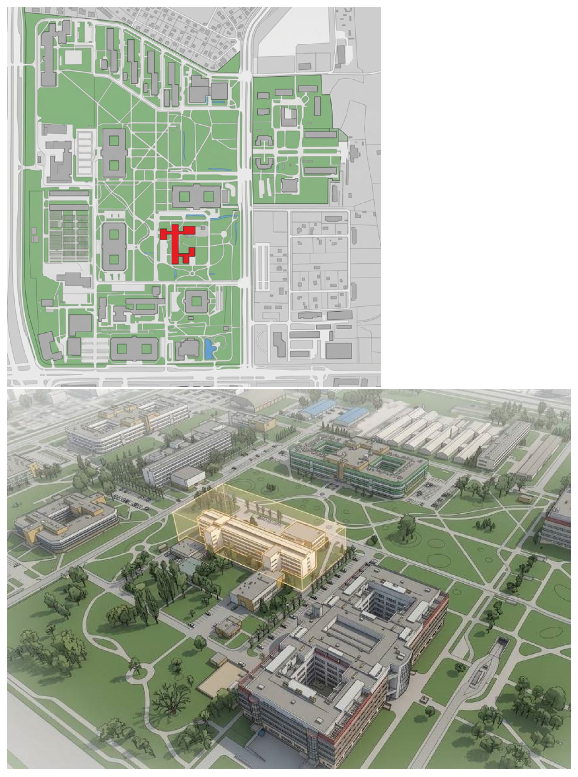
Figure 4.
Accessibility for people with mobility and visual impairments in B33 building, Warsaw University of Life Sciences campus.
Figure 4.
Accessibility for people with mobility and visual impairments in B33 building, Warsaw University of Life Sciences campus.
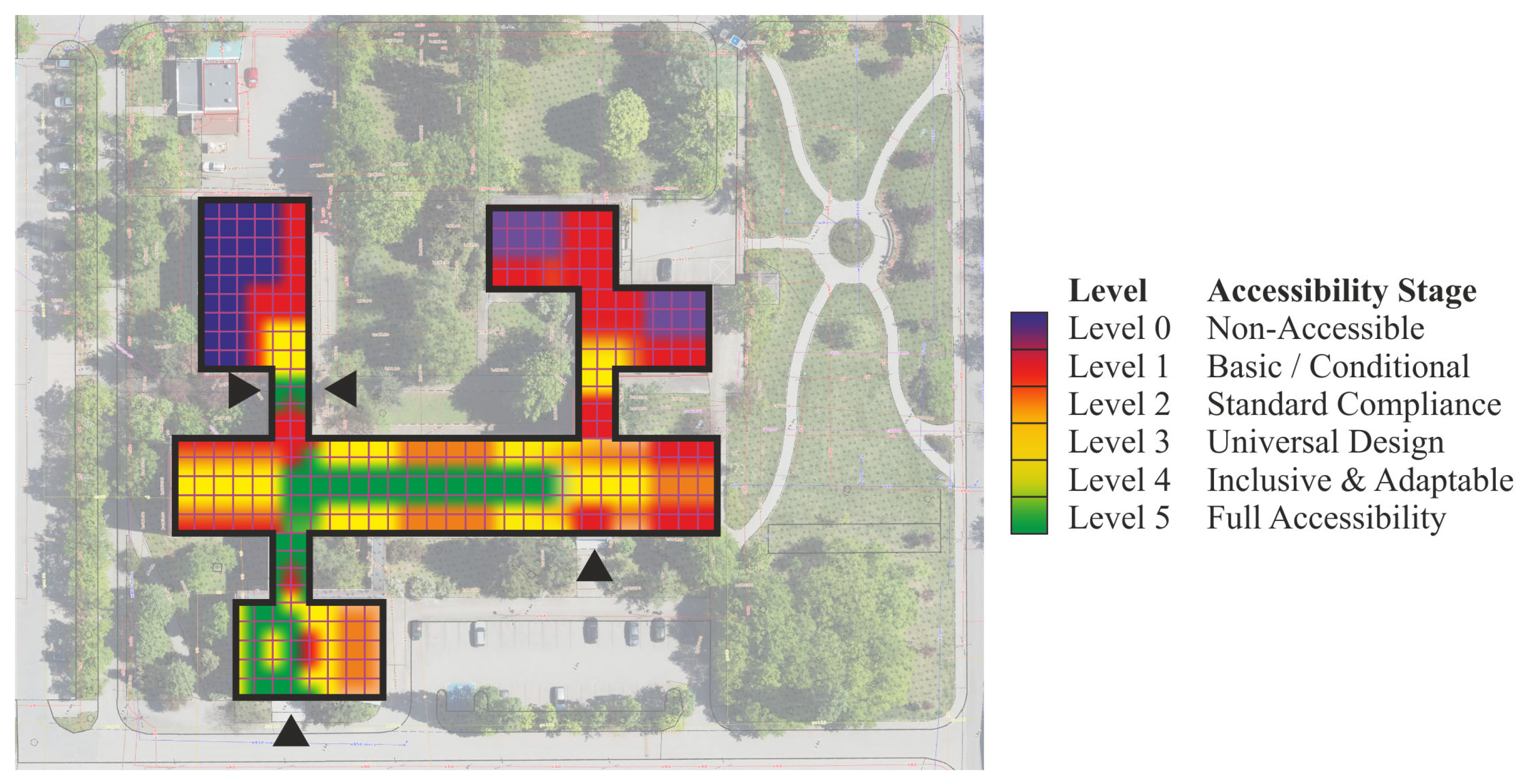
Figure 5.
Multi-layer architecture of a cognitive digital twin (CDT) on a macro scale.
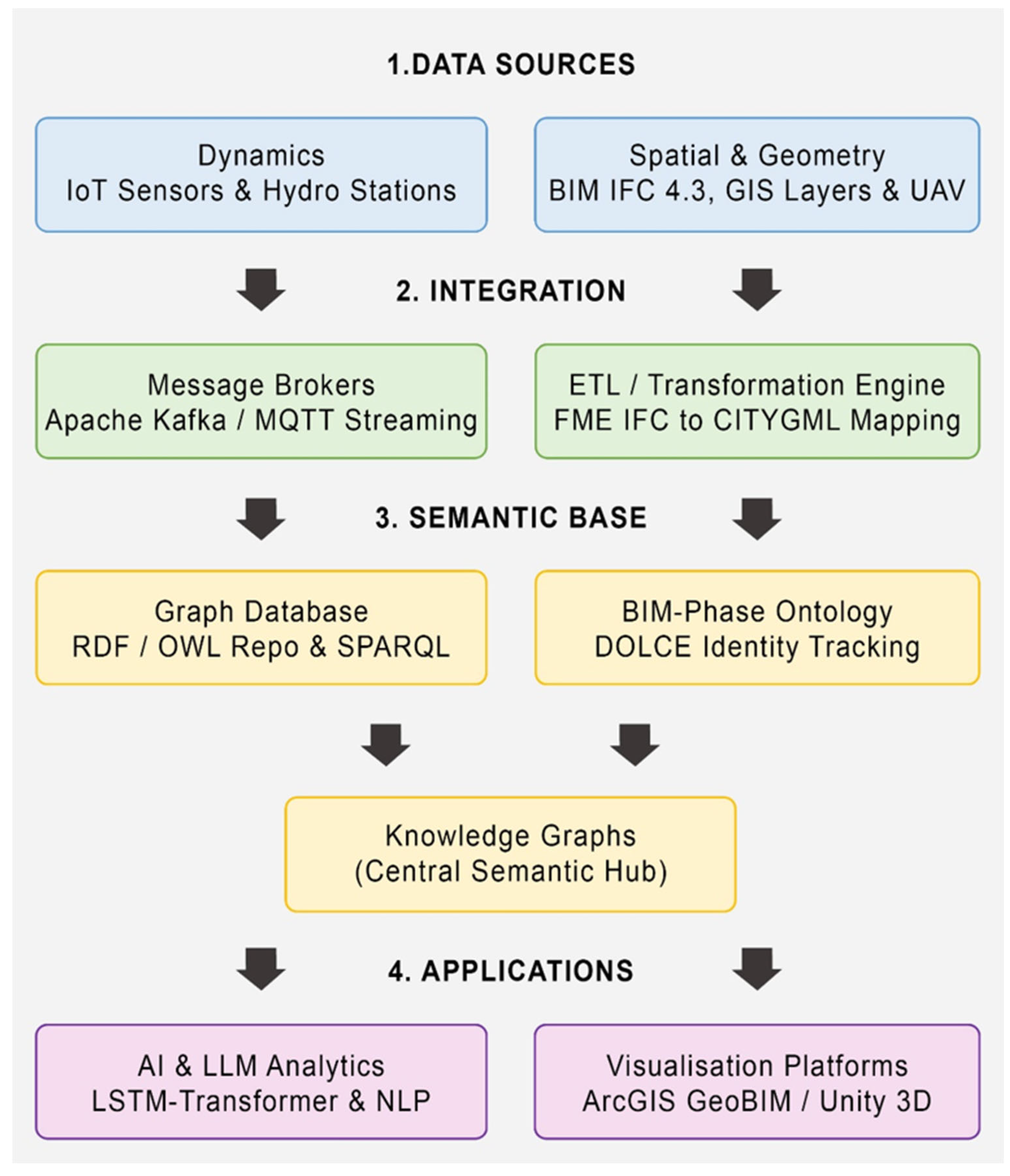

Table 1.
Comparison of BIM and GIS technological paradigms. Source: Own elaboration based on the article “Integracja BIM i GIS—Wyzwania i Ograniczenia.”[15].
Table 1.
Comparison of BIM and GIS technological paradigms. Source: Own elaboration based on the article “Integracja BIM i GIS—Wyzwania i Ograniczenia.”[15].
| Feature / Paradigm | BIM Technology | GIS Technology |
|---|---|---|
| Primary operational scale | Micro-scale (single object, component, engineering detail) | Macro-scale (spatial surroundings, terrain topography, urban network) |
| Database structure | Object-oriented, encapsulation, polymorphism, inheritance, instantiation | Primarily relational database, multidimensional tables, spatial attributes |
| Coordinate systems | Local coordinate systems (Cartesian, project origin point) | Global coordinate systems (geographic, projected, ellipsoidal) |
| Data format standard | Open standards (e.g., IFC) and proprietary formats (e.g., RVT) | OGC standards (e.g., CityGML, CityJSON), Shapefile formats, GeoJSON |
| Time management | Project phases, schedules (4D), asset lifecycle | Spatiotemporal analyses, dynamic streaming of sensor data |
Table 2.
Maturity levels of digital representations.
| Maturity Level | Representation Name | Data Flow Characteristics | Integration Depth |
|---|---|---|---|
| Level 1 | Digital Model | Manual data exchange between the physical object and the virtual model. Lack of automatic coupling. | Lowest. A change in the physical world does not automatically affect the virtual model and vice versa. |
| Level 2 | Digital Shadow | Automatic unidirectional data flow: from the physical object (IoT sensors) to the digital model. | Medium. The digital model dynamically reflects the actual state, enabling passive monitoring, visualization, and analysis. |
| Level 3 | Digital Twin | Fully automated, bidirectional data flow. Closed-loop feedback system. | Highest. The virtual model analyzes data using AI, simulates scenarios, and sends control commands back to the physical object. |
Table 3.
Analysis of macro-scale case studies of digital representations.
| Project Name and Location |
Scale and Infrastructure Type | Applied Integration Technologies | Main Functionalities and Applications | Maturity Level (2026) |
|---|---|---|---|---|
| smartBRIDGE Hamburg (Germany) | Local scale / Köhlbrand suspension bridge | Over 500 IoT sensors, integration with 3D structural model | Structural Health Monitoring (SHM), predictive maintenance, load-bearing capacity analysis | Advanced Digital Shadow with automated diagnostics elements |
| M-30 Highway Madrid (Spain) | Regional scale / 200 km of expressways, 48 km of tunnels, bridges | BIM (LOD 300) + GIS + Relational Database integration, point clouds | Monitoring over 400 KPIs, facility management, maintenance management monitoring, visualization, and analysis. | Digital Shadow integrated with CMMS systems and inventory databases |
| Virtual Singapore (Singapore) | Macro scale / Entire urban agglomeration | Over 100,000 sensors, AI LSTM-Transformer models, GIS | Traffic simulations, spatial planning, flow prediction | Digital Twin (bidirectional traffic management via urban signaling) |
| Zürich City Twin (Switzerland) | Macro scale / Metropolitan area | ArcGIS GeoBIM, ArcGIS Velocity, Revit/IFC, IoT sensors | Sihl River flood simulations, climate analyses, building evacuation monitoring | Advanced Digital Shadow integrated with hydrodynamic models |
Table 4.
Analysis of macro-scale case studies of digital representations.
| Research Project | Primary Urban Design & Resilience Focus | Crisis Domain Alignment | GeoBIM Technology Integration |
|---|---|---|---|
| NTU EcoCampus, Singapore | District-scale microclimate simulation, solar exposure analysis, and urban heat island mitigation across 200+ structures. | Decarbonization, urban climate adaptation, and resource optimization at the neighborhood scale. | 3D GeoBIM + Physical energy engines (IES-VE) |
| University of Turin, Italy | Pedestrian flow analysis, evacuation routing, and spatial bottleneck identification across a dispersed urban campus. | Mass evacuation, fire emergency management, and rapid spatial response in high-density areas. | BIM-GIS integration + Agent-based crowd simulation |
|
Mansoura University, Egypt |
Dynamic traffic movement, public realm reorganization, and evidence-based spatial decision-making during maintenance. | Maintaining spatial continuity and public space functionality during urban infrastructure disruptions. | 3D-GIS (Esri CityEngine) + Web-Scene portal + VR |
| Politecnico di Milano, Italy | Historical urban fabric protection, heritage conservation, and adaptive reuse under environmental pressures. | Preserving architectural identity, heritage integrity, and functional continuity under anthropogenic stress. | HBIM + GIS + Environmental BMS sensors |
| Warsaw University of Life Sciences, Poland | Interspecies spatial design, accessibility mapping, neurodiversity accommodations, and multi-user comfort on a 72-ha site. | Addressing spatial segregation, vulnerable population needs, and biodiversity loss in urban environments. | Parametric BIM + GIS spatial analysis + Field survey data |
Disclaimer/Publisher’s Note: The statements, opinions and data contained in all publications are solely those of the individual author(s) and contributor(s) and not of MDPI and/or the editor(s). MDPI and/or the editor(s) disclaim responsibility for any injury to people or property resulting from any ideas, methods, instructions or products referred to in the content. |
© 2026 by the authors. Licensee MDPI, Basel, Switzerland. This article is an open access article distributed under the terms and conditions of the Creative Commons Attribution (CC BY) license (http://creativecommons.org/licenses/by/4.0/).
Copyright: This open access article is published under a Creative Commons CC BY 4.0 license, which permit the free download, distribution, and reuse, provided that the author and preprint are cited in any reuse.