

Submitted:
05 August 2026
Posted:
06 August 2026
You are already at the latest version
Abstract
Geospatial Artificial Intelligence (GeoAI) is increasingly used to integrate remote sensing, geographic information systems, machine learning, Internet of Things sensing, weather information, soil data, and farm-management records for precision agriculture. This systematic review examines how GeoAI supports crop monitoring, yield forecasting, pest and disease detection, soil-property mapping, irrigation and nutrient management, climate adaptation, and decision support. Recent literature published between 2019 and 2026 was synthesized to characterize application domains, data sources, model families, multimodal integration approaches, cloud–edge processing pathways, deployment models, benefits, and barriers. The review shows that GeoAI is most useful when heterogeneous observations are combined into field-validated, interpretable, and timely decision-support products rather than used only for isolated mapping or retrospective prediction. Mature applications include yield estimation, crop monitoring, disease detection, and soil-property prediction, while emerging directions include digital twins, explainable AI, uncertainty-aware recommendations, edge analytics, and privacy-preserving data sharing. Reported benefits include improved prediction accuracy, earlier stress detection, more targeted input use, and potential environmental gains, but outcomes remain context-dependent. Wider adoption is constrained by data quality, interoperability, model generalization, computation, connectivity, privacy, affordability, digital literacy, and institutional support. Future work should prioritize trustworthy models, standardized data ecosystems, operational validation, affordable tools, clear governance, and inclusive co-design.
Keywords:
precision agriculture
; geospatial science
; artificial intelligence
; remote sensing
; agronomy
; data science
1. Introduction
Precision agriculture is increasingly influenced by the convergence of geospatial technologies and artificial intelligence (AI) [1], increasingly described as Geospatial Artificial Intelligence (GeoAI) [2]. GeoAI combines geographic information systems (GIS) [3], remote sensing [4], machine learning and deep learning [5], spatial statistics, and decision analytics to convert spatially explicit agricultural observations into operational knowledge [2]. In precision agriculture, this convergence is particularly important because crop performance, soil fertility, pest pressure, water availability, and management responses vary strongly across space and time [3]. By linking AI models with georeferenced satellite data [6], unmanned aerial vehicle (UAV) imagery [7], Internet of Things (IoT) sensing [8], weather observations [9], soil information [10], and farm-management data [11], GeoAI can support more spatially explicit monitoring, prediction, and intervention than conventional field-scale management approaches [12].
Figure 1 is organized from left to right to distinguish observation from interpretation and action. The source layer contains satellite and UAV imagery, proximal and IoT sensors, weather and climate data, and soil and farm records. These streams converge in spatial-temporal data integration before entering cloud or edge data services and GeoAI analytical techniques. The validated decision-support stage then produces crop-health and yield forecasts, pest and disease scouting priorities, prescription maps, and irrigation, soil, and climate advisories. This structure reflects the article’s emphasis on multimodal fusion, scale alignment, validation, and actionable outputs.
The architecture shown in Figure 1 illustrates a representative information flow for a GeoAI-enabled precision agriculture system [2]. Earth observation often begins with satellites that acquire multispectral, hyperspectral, thermal, or radar imagery over agricultural landscapes [4,6]. These observations support regional-scale applications such as vegetation health assessment [6], land-cover monitoring [13], crop classification [3], drought assessment [14], and the derivation of vegetation indices including NDVI, EVI, and LAI [15]. Satellite observations can provide repeated temporal coverage for long-term monitoring of crop development and environmental change [6].
Satellite data are transmitted to ground station antennas, which receive, decode, and distribute Earth observation products to cloud computing platforms [16]. The cloud storage component represents scalable computational infrastructures where satellite imagery [6], UAV observations [7], weather data [9], historical records, and field measurements [17] can be stored, synchronized, and processed. Cloud environments can also provide computational resources for executing machine learning algorithms [5], managing large geospatial datasets [16], and disseminating analytical products to multiple users [18].
Complementing satellite observations, unmanned aerial vehicles (UAVs) or drones acquire very high spatial resolution imagery for field-scale analysis [7]. Equipped with RGB, multispectral, hyperspectral, thermal, or LiDAR sensors, drones can capture detailed information on crop vigor [7], canopy structure [7], pest infestations [19], disease symptoms [20], nutrient deficiencies [21], irrigation performance [22], and plant stress [20] that may not always be resolved by satellite imagery. High-resolution aerial images can therefore complement satellite observations by providing localized assessments for precision interventions [7].
The field layer of the ecosystem consists of interconnected Internet of Things (IoT) devices and proximal sensing technologies that can monitor environmental and agronomic conditions at high temporal frequency [8,23]. GPS-enabled equipment can provide precise geolocation of agricultural machinery, livestock, and field operations, enabling site-specific management and the generation of spatially referenced datasets [3,24]. Soil moisture sensors can measure water availability within the root zone to support irrigation scheduling [22,25], while soil temperature sensors can monitor thermal conditions that influence seed germination, crop growth, and microbial activity [10]. Soil pH sensors can provide estimates of soil acidity and alkalinity, supporting nutrient management and variable-rate fertilizer application [21,26]. Additional IoT sensors may monitor atmospheric conditions [9], solar radiation, rainfall [9], or equipment status [24], providing real-time contextual information for predictive models [23].
Communication infrastructures connect these distributed sensing platforms with cloud-based GeoAI services [16]. Data originating from satellites [6], drones [7], field sensors [23], weather stations [9], and agricultural machinery [24] can be transmitted through wireless communication networks, allowing observations collected at different temporal frequencies and spatial resolutions to be integrated into a common geospatial database [27]. This interoperability supports the fusion of heterogeneous datasets, one of the defining characteristics of GeoAI systems [12].
Within the cloud environment, artificial intelligence, machine learning, deep learning, and spatial analytics can transform these multimodal observations into actionable information [2,5]. Typical analytical outputs include crop health monitoring [20], yield prediction [28], irrigation recommendations [22], soil property mapping [29], pest and disease detection [30], nutrient management [21], anomaly detection [31], and environmental risk assessment [32]. The resulting products can be delivered to farmers, agronomists, consultants, and policymakers through dashboards [18], geographic information systems [3], farm management platforms [11], mobile applications [33], or automated machinery [24], enabling timely and spatially explicit decision-making [34].
The growing interest in GeoAI reflects broader changes in agricultural data ecosystems [16]. Modern farms and research programs can generate high-volume and heterogeneous data streams from Earth observation platforms [13], proximal sensors [10], machinery telemetry [24], mobile devices, and field measurements [17]. These data sources provide potentially complementary information: satellite imagery supports regional and repeated crop monitoring [6], UAV imagery can capture fine-scale canopy and stress patterns [7], IoT and soil sensors can provide near-real-time field conditions [23], and weather and climate datasets contextualize crop development and risk [9]. Machine learning and deep learning techniques are often used to integrate these data streams [35], identify nonlinear relationships [5], and generate predictions for yield [28], crop health [20], soil properties [26], resource demand [36], and management timing [34].
Applications of GeoAI in precision agriculture are reported across multiple domains [37]. Yield estimation studies increasingly combine remote sensing [6], weather observations [9], soil information [10], and temporal deep learning [28] with the aim of improving prediction accuracy and supporting risk-aware management [2]. Pest and disease detection has been investigated using convolutional neural networks (CNNs) [30], Vision Transformers [38], hybrid CNN–Transformer architectures [39], object detection [19], and segmentation models applied to UAV, satellite, and field imagery [20]. Soil parameter mapping has similarly been supported by multimodal learning [40], satellite-image fusion [41], Random Forest models [26], and deep learning approaches that link remote sensing products with field and proximal soil observations [29]. These developments suggest that GeoAI is better understood not as a single method but as a methodological framework for integrating spatial data, AI models, and agronomic knowledge [2].
Beyond prediction, GeoAI is increasingly discussed as a decision-support layer for agricultural management [34]. Data fusion [12], explainable AI [42], digital twins [43], dashboards [18], and real-time processing pipelines [31] can help translate complex spatial information into actionable recommendations for irrigation scheduling [22], fertilization [21], pesticide use [44], crop scouting [20], and site-specific management [3]. These capabilities are relevant to productivity [36] and sustainability objectives [45]: precision technologies may improve input-use efficiency [21], reduce waste [46], support environmental monitoring [32], and contribute to resilience planning for drought [14], climate variability [47], and degraded production conditions [48].
Despite these opportunities, the literature remains fragmented across application domains [37], sensing platforms [20], analytical methods [49], crops, regions, and implementation contexts [50]. Many studies report promising model performance, yet persistent barriers may limit the translation of GeoAI from research prototypes to reliable operational systems [51]. These barriers include data quality and metadata gaps [52], interoperability limitations [27], weak cross-regional model generalization [53], insufficient validation [51], limited rural connectivity [54], computational scalability [16], high adoption costs [55], digital literacy constraints [33], privacy concerns [56], unclear data ownership [57], and the need for trustworthy and explainable AI governance [58]. Such challenges are especially important for smallholder and resource-limited farming systems, where infrastructure [55], affordability [59], training [33], and institutional support [60] may influence whether GeoAI contributes to inclusive agricultural development.
Given this rapidly evolving and multidisciplinary landscape, a systematic synthesis can help clarify what GeoAI currently contributes to precision agriculture [2], which methods and data sources are most commonly used [49], what evidence exists for agronomic and environmental benefits [45], and which barriers continue to constrain adoption [50]. This review addresses that need by examining recent literature on GeoAI-enabled precision agriculture, with emphasis on application domains [37], multimodal data integration [12], machine learning and deep learning methods [5], decision-support systems [34], reported impacts [36], implementation challenges [51], and future research directions [61]. By consolidating evidence across these themes, the review aims to provide researchers, practitioners, and policymakers with a synthesized understanding of the current state of GeoAI and the priorities for developing reliable [51], explainable [42], scalable [16], and equitable intelligent agricultural systems [60].
2. Review Methodology
This review follows a structured systematic-review protocol inspired by PRISMA-style reporting and adapted to the interdisciplinary scope of GeoAI-enabled precision agriculture. The methodology was designed to identify, screen, classify, and synthesize peer-reviewed literature addressing the use of geospatial data, artificial intelligence, machine learning, remote sensing, IoT sensing, and decision-support systems in agricultural management. The review emphasizes conceptual coverage, methodological trends, data sources, reported outcomes, and adoption barriers rather than a formal meta-analysis, because the reviewed studies differ substantially in crops, regions, sensors, algorithms, evaluation metrics, and deployment contexts.
2.1. Scope, Research Questions, and Terminology
The scope of the review is limited to studies in which geospatial information and AI-based analytical methods are explicitly connected to precision agriculture or smart farming. In this article, GeoAI refers to the integration of geographic information systems (GIS), remote sensing, spatial analytics, machine learning, deep learning, and georeferenced agricultural data for monitoring, prediction, optimization, and decision support. Precision agriculture is used to describe site-specific and data-driven management practices that seek to improve productivity, input-use efficiency, environmental sustainability, and operational decision-making.
The review is organized around five guiding research questions:
- RQ1.
- What are the current application domains of GeoAI in precision agriculture, and how have these applications evolved in recent years?
- RQ2.
- Which GeoAI techniques, machine learning algorithms, and geospatial data sources are most frequently employed, and how are they integrated to support agricultural decision-making?
- RQ3.
- What evidence exists regarding the effectiveness of GeoAI in improving agricultural productivity, resource-use efficiency, environmental sustainability, and operational decision-making?
- RQ4.
- What technical, operational, socio-economic, and governance challenges limit the implementation and large-scale adoption of GeoAI in precision agriculture?
- RQ5.
- What research gaps and emerging directions should guide the next generation of GeoAI-enabled precision agriculture systems?
These questions were complemented by cross-cutting coding questions concerning the agricultural problem addressed, crop or production system, country or region, sensing platform, data modality, algorithmic approach, evaluation metrics, reported benefits, and stated limitations.
2.2. Literature Search Strategy
The literature search was designed to capture the diversity of terminology used across precision agriculture, remote sensing, GIScience, agricultural engineering, data science, and AI. Searches were oriented toward peer-reviewed studies published from 2019 to 2026, reflecting the recent acceleration of deep learning, transformer architectures, multimodal data fusion, IoT-enabled sensing, and decision-support systems in agriculture. Foundational or highly relevant earlier studies were retained when they provided conceptual, methodological, or benchmarking context.
Bibliographic searches were conducted primarily in Scopus and the Web of Science Core Collection. Additional backward and forward snowballing was used to identify relevant studies cited by review papers, methodological articles, and highly cited empirical studies. Search results were limited to English-language journal articles, conference papers, reviews, and book chapters with sufficient methodological detail.
Search string structure
The database queries combined four groups of terms: (i) GeoAI and geospatial technologies, (ii) AI and machine learning methods, (iii) precision-agriculture application domains, and (iv) sensing and data sources. Boolean operators were adapted to each database syntax. A representative search structure is shown in Table 1.
The keyword groups used to refine and validate the search strategy were:
- GeoAI and geospatial terms:GeoAI, geospatial artificial intelligence, GIS, spatial analytics, remote sensing, satellite imagery, UAV, drone, geospatial data fusion, spatial prediction, digital twin.
- AI and modelling terms:machine learning, deep learning, random forest, XGBoost, CNN, RNN, LSTM, GRU, transformer, vision transformer, YOLO, object detection, segmentation, graph neural network, explainable AI, uncertainty quantification.
- Agricultural application terms:precision agriculture, smart farming, digital agriculture, crop yield, yield prediction, crop monitoring, pest detection, disease detection, soil mapping, soil moisture, irrigation scheduling, fertilizer recommendation, variable-rate application, decision support system.
- Data-source terms:IoT, sensor network, proximal sensing, field sensor, weather data, climate data, vegetation index, NDVI, EVI, LAI, multispectral, hyperspectral, LiDAR.
2.3. Eligibility Criteria
The following inclusion and exclusion criteria were applied during screening.
Inclusion criteria
- Peer-reviewed journal articles, review papers, book chapters, or full conference papers addressing GeoAI, AI, machine learning, deep learning, remote sensing, GIS, or spatial analytics in precision agriculture.
- Studies focused on at least one precision-agriculture task, including crop yield estimation, crop monitoring, pest or disease detection, soil property mapping, irrigation, fertilization, variable-rate input management, climate adaptation, agricultural robotics, or decision support.
- Studies using geospatial or spatially referenced data, such as satellite imagery, UAV imagery, IoT sensors, weather observations, soil measurements, field data, farm-management data, or derived vegetation indices.
- Studies reporting sufficient information to identify the agricultural application, data sources, modelling approach, and either quantitative performance metrics or qualitative implementation insights.
Exclusion criteria
- Studies unrelated to agriculture, crop production, smart farming, or agricultural decision-making.
- Studies using AI or machine learning without any geospatial, remote-sensing, field-scale, or spatially referenced agricultural component.
- Purely theoretical AI papers without agricultural application or papers focused only on hardware without analytical or decision-support relevance.
- Short abstracts, posters, editorials, opinion pieces, non-English publications, duplicate records, and records without accessible bibliographic or methodological information.
2.4. Screening and Study Selection
All retrieved records were imported into a reference-management workflow and de-duplicated. Screening was conducted in two stages. First, titles and abstracts were reviewed to remove records outside the GeoAI, precision-agriculture, remote-sensing, or smart-farming scope. Second, full texts were examined to confirm eligibility, extract methodological details, and identify whether each study contributed to one or more research questions. When relevance was ambiguous, priority was given to studies that combined spatially referenced agricultural data with AI-based modelling or decision-support methods.
The screening process was organized to support PRISMA-style reporting, including the number of records identified, screened, excluded, and retained for synthesis. Exclusion reasons included wrong domain, no geospatial component, no AI or machine learning component, insufficient methodological information, duplicate record, and inaccessible full text.
2.5. Data Extraction and Coding
For each eligible study, information was extracted and coded into a structured matrix. The main coding categories were: publication year; study type; crop or agricultural system; country or region; application domain; sensing platform; data source; spatial and temporal scale; algorithm or modelling approach; evaluation metric; reported outcome; implementation barrier; and stated future research need. Application domains were grouped into crop yield estimation, pest and disease detection, soil parameter mapping, resource optimization, climate adaptation, and decision support systems.
Methods were coded into broader analytical families, including traditional machine learning, deep learning, transformer-based models, object detection and segmentation, multimodal data fusion, GIS-based spatial analysis, explainable AI, uncertainty quantification, digital twins, and dashboard-based decision support. Data sources were coded as satellite, UAV, IoT/proximal sensor, weather or climate, soil measurement, field image, farm-management record, or derived index.
Figure 2 shows the complete PRISMA diagram with the literature review search.
2.6. Synthesis Approach and Limitations
The evidence was synthesized narratively and thematically rather than through statistical meta-analysis. This choice reflects the heterogeneity of the literature: studies differ in crops, regions, sensors, spatial resolution, model architectures, validation designs, and reported metrics. The synthesis therefore emphasizes patterns across application domains, recurring methodological choices, common data sources, reported benefits, and barriers to implementation.
The review has several limitations. First, restricting the search primarily to Scopus and Web of Science may omit relevant grey literature, technical reports, proprietary deployments, or regional publications. Second, English-language screening may underrepresent research from some agricultural regions. Third, rapid development in GeoAI means that very recent models and platforms may not yet be fully represented in peer-reviewed literature. Finally, because many studies evaluate models in controlled or region-specific settings, reported performance and sustainability benefits should be interpreted with caution when generalizing across crops, climates, farming systems, and socio-economic contexts.
3. Current Application Domains of GeoAI in Precision Agriculture
The reviewed literature suggests that GeoAI is moving from isolated remote-sensing applications [13] and GIS-based workflows [3] toward integrated, AI-enabled agricultural intelligence systems [2]. Across the studies examined, six application domains are prominent in the reviewed studies: crop yield estimation [28], pest and disease detection [20], soil parameter mapping [26], resource optimization [36], climate adaptation [62], and decision support systems [34]. These domains often share a methodological pattern: heterogeneous geospatial observations are fused [12] with machine learning or deep learning models [5] to generate spatially explicit predictions [6], classifications [30], recommendations [18], or management zones [10].
A recurring trend is the increasing use of multimodal data integration [12]. Satellite imagery can provide broad spatial and temporal coverage [6], UAV imagery can offer field-scale detail [7], IoT and proximal sensors can support near-real-time monitoring [23], and weather [9], soil [10], and farm-management records [11] can provide agronomic context. GeoAI methods are often more useful when they combine these sources rather than relying on a single data stream [31]. This integration is especially visible in yield forecasting [6], soil mapping [26], irrigation scheduling [63], and decision-support systems [34], where predictive performance may depend on capturing interactions among crop condition [7], soil variability [10], weather [9], and management practices [51].
The reviewed literature indicates that GeoAI applications span a wide range of agricultural production systems, although certain crops appear to have received considerably more attention due to their economic importance, global distribution, and availability of remote sensing and field datasets. As shown in Table 2, the choice of crop can strongly influence the analytical objectives, sensing platforms, and artificial intelligence methods employed. Cereal crops such as wheat, maize, and rice are prominent in studies on yield forecasting and resource optimization, whereas high-value horticultural and perennial crops are more frequently associated with disease detection, canopy characterization, and high-resolution UAV-based monitoring. This diversity suggests the adaptability of GeoAI methodologies across different agricultural environments while highlighting a growing trend toward crop-specific intelligent management systems.
Table 2 suggests that GeoAI applications are closely associated with crop characteristics, production systems, and management objectives [2,51]. Cereals, particularly wheat [6], maize [10,64], and rice [29,66], are prominent in the literature partly because of their global economic importance and the availability of extensive satellite time-series [6] and field observations suitable for large-scale predictive modeling [17]. These crops are frequently investigated for yield forecasting [28], resource optimization [36], and climate adaptation [62].
Conversely, horticultural crops such as potato [7], and perennial crops such as vineyards [68] and fruit trees [62], often require higher spatial resolution observations obtained from UAVs [7] or proximal sensing platforms [10]. GeoAI studies involving these crops often emphasize disease detection [20], canopy analysis [7], fruit monitoring [19], and precision management at the individual plant or row level [68]. Across all crop groups, recent research indicates a growing reliance on multimodal data fusion [12], combining satellite imagery [6], UAV observations [7], IoT measurements [23], weather information [9], and soil data [10] with machine learning and deep learning algorithms [5] to support more accurate and operationally relevant decision-support products [34]. The table therefore suggests that GeoAI methodologies are adaptable [2], while the selection of sensing platforms, analytical techniques, and computational models remains dependent on the agronomic characteristics and management requirements of each crop system [51].
The application domains also appear to differ in maturity. Yield estimation [28], crop monitoring [49], and pest or disease detection [20] are comparatively mature in the reviewed literature because they often benefit from abundant imagery and well-established evaluation metrics. Soil mapping [26] and resource optimization [36] are expanding but remain more dependent on field calibration [17], local agronomic knowledge [70], and sensor availability [71]. Climate adaptation [62] and decision-support systems [34] are discussed as integrative domains that require not only accurate models but also explainability [42], uncertainty communication [11], operational usability [18], and trust among end users [56].
Table 3 summarizes principal application domains identified in the reviewed studies, highlighting representative GeoAI approaches, data sources, and reported outcomes.
Overall, the strongest evidence base in this review appears to concern predictive applications, particularly yield estimation [28], and diagnostic applications, especially pest or disease detection [20]. However, an important opportunity lies in connecting these predictive models to operational decision support [34], where GeoAI may help close the loop between sensing [31], interpretation [42], recommendation [18], and action [77]. Supporting this transition requires interoperable data systems [27], explainable models [42], robust validation across regions [51], and interfaces that can be used by farmers, agronomists, and advisors under real management constraints [77].
3.1. Evolution of GeoAI Applications
The evolution of GeoAI in precision agriculture can be interpreted in this review as a shift from task-specific prediction [28] toward integrated sensing–modelling–decision workflows [2]. Earlier applications were often organized around remote-sensing classification [3], yield prediction [6], and soil mapping [26], often using conventional machine learning models trained on single data sources [40]. More recent work often combines satellite imagery [6], UAV observations [7], IoT and proximal sensors [23], weather data [9], soil measurements [10], and farm-management records [11] to improve spatial coverage [4], temporal continuity [15], and operational relevance [31].
This transition is particularly visible in image-intensive tasks. CNNs [30], Vision Transformers [38], hybrid CNN–Transformer models [39], object-detection frameworks [19], and segmentation methods [39] are increasingly used for crop monitoring [49], pest and disease detection [20], canopy assessment [7], and field-scale object recognition [19]. These methods can improve feature extraction from high-resolution imagery [30], but they also create a need for large annotated datasets [49], transferability assessment [78], and explainable outputs that can be trusted by agronomists and farmers [42].
A second trend is the reported move toward real-time and near-real-time analytics [79]. Cloud platforms [16], edge computing [80], AIoT systems [23], and daily ground–satellite fusion [15] can enable faster detection of crop stress [7], irrigation needs [22], disease pressure [20], and operational anomalies [73]. However, this evolution also exposes practical constraints: data latency [79], sensor calibration [71], connectivity gaps [54], interoperability [27], and model validation [51] remain critical barriers to field deployment.
Overall, GeoAI can be viewed as evolving from a collection of analytical tools [2] into a broader decision-support framework [34]. Its future value is likely to depend less on isolated model accuracy [51] and more on whether models can be integrated into trustworthy [58], explainable [42], scalable [16], and context-aware farm-management systems [18].
Although the GeoAI ecosystem describes major sources of agricultural information, an operational decision-support system also often requires a structured computational workflow that transforms raw geospatial observations into actionable knowledge. Beyond the analytical methods themselves, modern GeoAI platforms often rely on cloud-native infrastructures capable of ingesting, storing, processing, and disseminating large volumes of heterogeneous agricultural data. Figure 3 presents a generalized end-to-end processing architecture inspired by operational GeoAI systems commonly used in precision agriculture. The workflow illustrates how satellite observations, cloud computing services, machine learning platforms, databases, and user-facing applications can be integrated into a scalable decision-support framework.
It is relevant to separate the data-processing stages from the service layer and uses explicit directional to highlight the relationship between ingestion, harmonization, analytics, validation, storage, and delivery. The service examples are multisource: object storage, compute, ML training, workflow orchestration, geospatial databases, APIs, and user interfaces may be supplied by AWS, Microsoft Azure, Google Cloud Platform, or interoperable on-premise infrastructure.
Figure 3 separates the logical pipeline from the technologies that can implement it. The top row shows the ordered transformation of observations into decisions: ingestion, harmonization, analysis, validation and serving, and decision or field action. The lower service layer shows how storage, compute, ML training and inference, workflow orchestration, geospatial databases, APIs, map services, and dashboards support those stages. The arrows therefore represent data and control dependencies rather than a single vendor-specific architecture.
As illustrated in Figure 3, the workflow begins with the acquisition of satellite imagery for a selected region of interest through a ground station or data provider [4,6]. Incoming imagery is transferred to cloud infrastructure [16], where storage services such as Amazon S3 act as centralized repositories for raw and processed geospatial datasets, while data-streaming services (e.g., Amazon Kinesis) can enable continuous ingestion of imagery and sensor observations from multiple sources [23,31].
The preprocessing stage performs radiometric normalization, spatial resampling, pixel scaling, cloud masking, and image harmonization to generate analysis-ready data [13,52]. Computational resources such as Amazon EC2 can provide scalable virtual machines for executing computationally intensive preprocessing tasks [16], whereas interactive environments such as Jupyter Notebook can allow researchers and analysts to develop, validate, and prototype GeoAI algorithms using Python-based geospatial libraries before operational deployment [49,51].
The analytical stage combines conventional geospatial processing with machine learning and deep learning models [2,5]. Amazon SageMaker is illustrated as a platform that can support training predictive models, performing hyperparameter optimization, and deploying trained models as real-time inference endpoints [16,79]. These models may estimate vegetation indices [15], crop yield [28], crop health [20], soil properties [29], irrigation requirements [22], or detect pests and diseases [30] from multisource geospatial data [12]. The figure also represents predictive models executing regression analyses [26], time-series forecasting [28], feature extraction [49], and deep learning inference [5] to convert raw imagery into agronomically meaningful information [2].
Model predictions are subsequently orchestrated through serverless computing services such as AWS Lambda, which can execute processing functions without requiring dedicated server management [80]. Lambda functions can coordinate workflow automation [31], invoke trained SageMaker endpoints [79], perform spatial post-processing [3], and prepare results for dissemination [18]. Intermediate and final outputs are stored in operational databases, represented by Amazon RDS or DynamoDB, which can manage structured geospatial metadata [52], prediction results [28], historical observations [17], and user requests required by operational decision-support systems [34].
Following analytical processing, spatial products undergo post-processing operations including zonal statistics [3], spatial aggregation [2], uncertainty estimation [11], and the generation of standard geospatial services such as Web Map Services (WMS) and Web Feature Services (WFS) [27]. These interoperable services can facilitate integration with Geographic Information Systems (GIS) [3], farm management platforms [11], and external decision-support tools [34].
Finally, the processed products are published through cloud-hosted web applications, represented by AWS Amplify, which can provide a framework for developing interactive web portals and dashboards [18]. Farmers, agronomists, consultants, and policymakers may access vegetation maps [15], prescription maps [34], irrigation recommendations [22], yield forecasts [28], soil assessments [29], and other GeoAI products through intuitive graphical interfaces that support operational decision-making [18]. Although Figure 3 depicts an implementation based on Amazon Web Services, similar architectural principles may be applicable to other cloud computing ecosystems, including Microsoft Azure, Google Cloud Platform, or on-premise geospatial processing infrastructures [16,80]. The figure therefore represents a generalized cloud-native GeoAI architecture illustrating how Earth observation data are transformed into scalable, operational intelligence for precision agriculture [2,34].
An important transition identified across the reviewed literature is the evolution from algorithm-centric studies toward ecosystem-oriented GeoAI architectures [82,83]. Earlier research frequently evaluated individual machine learning algorithms for specific agricultural tasks, such as crop classification or yield prediction, whereas recent studies increasingly integrate sensing platforms, cloud infrastructures, spatial databases, real-time communication networks, explainable models, and decision-support interfaces into unified operational systems [81,84]. This evolution reflects a broader shift in digital agriculture, where the principal scientific challenge is no longer maximizing predictive accuracy alone but coordinating heterogeneous data streams, computational resources, and human decision-making processes [83]. Consequently, future GeoAI research is likely to be evaluated according to system robustness, interoperability, scalability, and operational impact rather than isolated algorithmic performance [82,84].
3.2. GeoAI Techniques, Machine Learning Algorithms, and Geospatial Data Sources
Modern GeoAI systems often combine three interdependent components: analytical techniques [2], machine learning algorithms [5], and geospatial data infrastructures [4]. GeoAI techniques such as multimodal data fusion [12], GIS-based spatial analysis [3], uncertainty quantification [11], explainable AI [42], digital twins [43], and near-real-time processing [79] can provide the workflow-level structure. Machine learning and deep learning algorithms can provide predictive or diagnostic capability [5]. Geospatial data sources can provide the spatial, temporal, and agronomic context needed to make predictions actionable [4].
The reviewed literature suggests that no single algorithmic family dominates all precision-agriculture problems [37]. Random Forest and other ensemble methods are often useful for tabular, soil, and moderate-size remote-sensing datasets because of their robustness and interpretability [26]. CNNs and object-detection models are commonly suited to image-based diagnosis and segmentation [30]. Recurrent networks and temporal deep learning methods can support yield forecasting and time-series modelling [6]. Transformer-based approaches [39] and graph-based approaches [26] are increasingly explored when spatial context, long-range dependencies, or multimodal representation learning are important [40].
Data-source selection is also important [12]. Satellite imagery supports regional-scale monitoring [6], UAV imagery supports high-resolution field diagnosis [7], IoT and proximal sensors provide local and near-real-time measurements [8], and weather and climate data support temporal interpretation [9]. Vegetation indices are derived products, usually calculated from satellite or UAV spectral bands, and summarize crop condition for integration into models [15]. Stronger GeoAI applications often combine complementary data streams [35] and explicitly address scale mismatch [12], missing observations [85], calibration [17], and validation [51].
Table 4 summarizes the principal categories of GeoAI techniques, machine learning algorithms, and geospatial data sources identified in the reviewed studies.
Taken together, these methods suggest that GeoAI performance depends on the alignment between agricultural task [50], data scale [12], model structure [5], and decision context [77]. Promising systems are not necessarily those using the most complex algorithms, but those that combine suitable data sources [35], validated models [51], interpretable outputs [42], and workflows that fit real farm operations [77].
Spatial scale represents one of the defining characteristics of GeoAI in agricultural applications. Satellite imagery, UAV observations, proximal sensing, machinery telemetry, and soil sampling each describe agricultural processes at different spatial supports and temporal frequencies. Integrating these heterogeneous observations therefore requires careful consideration of scale compatibility, spatial aggregation, temporal synchronization, and uncertainty propagation. Failure to address these differences may reduce predictive performance or generate recommendations that are inconsistent with field conditions. Consequently, effective GeoAI systems increasingly incorporate multiscale representations that connect regional monitoring with field-level management while preserving spatial consistency throughout the analytical workflow.
3.3. Integration of GeoAI Components for Decision-Making
Table 5 consolidates principal terms used across GeoAI-enabled precision agriculture studies. The table is organized by conceptual layer: the GeoAI framework layer describes system-level ideas such as multimodal fusion, explainability, and digital twins; the machine learning and deep learning layers summarize the most common predictive methods used in agricultural applications; the geospatial data layer lists the principal sensing and contextual data streams; and the evaluation layer highlights the metrics most frequently used to judge predictive performance.
The reviewed studies suggest that GeoAI decision-making is usefully understood as a sensing–modelling–recommendation chain [34] rather than as a set of isolated predictive models [2]. In this chain, satellite imagery supplies repeated regional observations [4], UAV imagery captures field-scale canopy and stress patterns [7], IoT and proximal sensors provide local and near-real-time measurements [8], and weather [9], soil [10], and farm-management records [11] add agronomic context. The value of GeoAI can therefore emerge from aligning these complementary data streams across spatial resolution [12], temporal frequency [15], sensor uncertainty [17], and management scale [35].
Once harmonized, these data are transformed into decision variables for yield forecasting [28], soil-property mapping [26], disease and pest detection [20], irrigation scheduling [22], variable-rate input application [21], and climate-risk assessment [47]. Strong workflows often combine multimodal fusion [12] with models that are matched to the task: temporal deep learning for crop-growth trajectories [6], CNNs and Transformer-based models for imagery [30], ensemble methods for tabular soil and weather covariates [26], and cloud–edge architectures for latency-sensitive monitoring [80].
A recurring insight across the literature is that decision quality may depend not only on predictive accuracy [51] but also on trust [56], timeliness [79], and interpretability [42]. Uncertainty quantification can help distinguish confident prescriptions from predictions requiring field verification [89], while explainable AI methods help relate model outputs to vegetation indices [15], soil properties [29], water status [25], disease symptoms [30], or weather anomalies [9]. These features are especially important when recommendations affect irrigation volumes [22], pesticide application [44], fertilizer rates [21], or harvest planning [28].
GeoAI is also being discussed in relation to closed-loop decision support in which sensing [31], analytics [2], prescription maps [34], alerts [18], and machinery or advisory actions [24] are connected through dashboards [18], digital twins [43], cloud platforms [16], and edge devices [90]. This transition may shift the emphasis from producing maps [3] to producing actionable, auditable recommendations that fit farm operations [77] and can be updated as new observations arrive [31].
Another emerging research direction involves the incorporation of foundation models and large multimodal models into GeoAI workflows [4,85]. Recent advances in vision-language models, geospatial foundation models, and large language models suggest opportunities for integrating remote sensing imagery, textual agronomic knowledge, weather forecasts, historical farm records, and farmer interactions within unified reasoning frameworks [12,85]. Such systems may facilitate automated report generation, conversational decision support, semantic retrieval of historical observations, and cross-modal interpretation of heterogeneous agricultural data [85,111,112]. Nevertheless, questions regarding spatial reasoning, hallucination, explainability, computational cost, and domain adaptation remain largely unresolved, indicating that foundation models should currently complement rather than replace specialized geospatial analytical methods [11,85,88].
3.4. Effectiveness of GeoAI for Agricultural Outcomes
The evidence base suggests that GeoAI is most consistently useful when it improves the specificity of agricultural decisions: where to scout [20], when to irrigate [22], how much input to apply [21], which fields are at risk [9], and how yield expectations are changing [28]. Yield prediction studies can benefit from fusing remote sensing [6], weather [9], soil [10], and temporal information [28]; crop-monitoring studies can benefit from high-resolution imagery [7] and segmentation [39]; and soil-mapping studies can benefit from combining field observations [26] with environmental covariates [29] and satellite-derived indicators [41].
Resource-use efficiency is another important outcome area. Precision irrigation [36], variable-rate fertilization [21], optical sensing [70], and sensor-based management [71] may reduce unnecessary water [22], nutrient [91], pesticide [44], fuel, and labor use [92] by replacing uniform field treatment with spatially differentiated management [3]. However, these gains depend on calibration quality [17], agronomic thresholds [70], farmer usability [18], and whether recommendations are operationally feasible under local constraints [93].
Environmental benefits appear promising but more conditional than productivity or efficiency gains [45]. Reduced fertilizer and pesticide use may lower runoff [46], contamination [32], and emissions [65], while improved water management may support drought resilience [14] and climate adaptation [47]. At the same time, life-cycle evidence [32] and review evidence [94] caution that digital agriculture may shift impacts to energy use [95], device production [96], data infrastructure [16], or poorly adapted interventions if deployment is not context-sensitive [62].
Operationally, GeoAI can strengthen decision-making by converting heterogeneous observations [12] into timely recommendations [34], prescription maps [34], risk alerts [18], and interpretable indicators [42]. More mature systems appear to be those that combine validated models [51] with farmer-facing interfaces [18], advisory workflows [33], and feedback loops from field observations [17]. In this sense, GeoAI should therefore be evaluated not only by model metrics such as accuracy or F1-score [67], but also by adoption readiness [97], decision latency [79], economic value [77], robustness across seasons [98], and accountability of recommendations [58].
Table 6 summarizes main outcome pathways identified in the reviewed literature.
Overall, GeoAI appears most effective as a decision layer [34] and optimization layer [36] for precision agriculture. Its most consistently reported benefits include support for improved prediction [28], earlier detection [20], targeted management [3], and reduced resource waste [21]; its environmental benefits [45] and socio-economic benefits [55] may be substantial but depend on implementation quality [51], governance [58], affordability [59], and local institutional capacity [60].
Beyond prediction accuracy, uncertainty estimation is emerging as a fundamental component of operational GeoAI [11]. Agricultural management decisions frequently involve irreversible actions, including irrigation, pesticide application, fertilization, and harvest scheduling, where incorrect recommendations may generate substantial economic or environmental consequences [34]. Consequently, uncertainty-aware GeoAI frameworks that quantify prediction confidence can improve risk communication and support adaptive decision-making [89]. Rather than providing deterministic recommendations, future operational systems may increasingly combine predictive outputs with confidence intervals, probability maps, or uncertainty surfaces, allowing farmers and advisors to prioritize field inspections where model confidence is low [11,89].
4. Application-to-Deployment Synthesis of GeoAI in Precision Agriculture
The reviewed literature suggests that GeoAI applications are converging around a common deployment logic: converting spatially explicit observations [2] into crop intelligence [28], soil intelligence [26], water intelligence [22], and risk intelligence [9] that can support field-level decisions [34]. Rather than treating yield prediction [6], disease detection [20], irrigation [36], and sustainability assessment [45] as separate domains, recent studies increasingly connect them through shared data infrastructures [16], multimodal fusion [12], model interpretability [42], and decision-support interfaces [18].
4.1. Yield Forecasting and Crop Health
Yield estimation appears to be one of the more mature GeoAI applications because it directly links remote sensing [6], weather variability [9], soil information [10], crop phenology [28], and management zones [10] to agronomic planning. Studies using county-level corn data [2], wheat and maize time series [6], UAV-derived potato indicators [7], and site-specific corn management zones [10] suggest that model performance can improve when satellite imagery [6] is complemented by proximal sensing [10], cultivar information [7], soil covariates [10], and temporal learning [28] rather than relying on vegetation indices alone [15].
Crop-health monitoring has been advanced through UAV imagery [19], satellite imagery [20], CNNs [30], Vision Transformers [38], object detectors [19], and segmentation models [39] that identify canopy stress [7], disease symptoms [30], pests [20], and within-field anomalies [73]. An important insight is that visual accuracy in controlled image datasets [100] may not be sufficient for operational disease management: models need to remain reliable under variable illumination [100], crop stage [49], background complexity [19], disease severity [39], and regional management practices [101]. Transfer learning [78], segmentation-enabled workflows [101], and field-scale validation [20] are therefore important for moving from image classification to actionable scouting and treatment decisions [19].
4.2. Resource Optimization, Soil Intelligence, and Climate Adaptation
GeoAI can support resource optimization by transforming heterogeneous data [12] into spatial prescriptions for irrigation [22], fertilization [21], pesticide use [44], and machinery operations [24]. Precision irrigation studies illustrate how satellite data [6], UAV data [7], IoT data [8], soil-moisture measurements [25], and weather data [9] can be combined to estimate crop water status and schedule water application [22], while variable-rate fertilization [21] and optical sensing [70] studies indicate the value of matching nutrient inputs to spatially variable soil and crop demand.
Soil-related applications are important because soil variability mediates both productivity [10] and environmental outcomes [45]. GeoAI models have been used to map soil properties [26], fertility [55], total nitrogen [29], soil moisture [25], and soil quality [102] by combining field sampling [26], proximal sensing [10], environmental covariates [29], and satellite observations [41]. These applications suggest a broader methodological lesson: remote sensing becomes more agronomically useful when it is anchored to ground truth [17] and interpreted through soil–crop–climate relationships [103] rather than treated as a purely spectral prediction problem [41].
Climate adaptation is discussed as an emerging cross-cutting application [62]. GeoAI may support drought-risk monitoring [14], climate-smart advisories [47], regional crop zoning [104], greenhouse-gas benchmarking [65], and resilience planning [105] by integrating remote sensing [4] with weather [9], soil [10], management [11], and socio-economic data [106]. However, climate-oriented GeoAI should account for local vulnerability [107], smallholder constraints [55], and low-connectivity environments [54]; otherwise, technically sophisticated tools may be less likely to support the farms most exposed to climate risk [108].
4.3. Data Systems, Explainability, and Secure Decision Support
The reviewed studies indicate that deployment readiness can depend on the data system [16] as much as on the model [51]. Robust GeoAI pipelines often require harmonized satellite [6], UAV [7], IoT [8], weather [9], soil [10], and farm-management data [11]; quality-control procedures for missing values [85], noise [17], and metadata [52]; and scalable cloud–edge infrastructures [80] that can support near-real-time analytics [79] without excluding farms with limited connectivity [54].
Explainability [42], uncertainty [11], privacy [109], and security [110] are recurring requirements for trustworthy decision support. XAI methods such as SHAP [42], LIME [42], Grad-CAM [30], surrogate models [111], and attention visualization [39] can help users understand why a system recommends irrigation [22], scouting [20], fertilization [21], or crop selection [111]. At the same time, uncertainty estimates can help flag recommendations that should be verified in the field [89]. Privacy [56] and cybersecurity safeguards [110] are also important because geospatial agricultural data may reveal sensitive information about farm size [109], production [109], finances [109], practices [57], and market position [105].
4.4. Reported Outcomes and Implementation Conditions
Reported outcomes are often positive for productivity [36], input efficiency [21], and decision timeliness [18], but they are not automatic [45]. Precision irrigation studies report water-saving potential [22], variable-rate management may reduce fertilizer use [21], automation may lower labor requirements [92], and integrated decision-support systems may improve water-use efficiency and soil sustainability [69]. Nevertheless, outcomes vary across crop type [67], region [9], technology maturity [51], calibration quality [17], farmer skill [33], and institutional support [112].
Environmental evidence is similarly promising but context-dependent [45]. Reduced water use [22], fertilizer use [21], pesticide use [44], fuel use [32], and energy use [95] may lower runoff [46], emissions [65], and contamination [32]; however, life-cycle assessments show that digital agriculture can also shift impacts through equipment manufacturing [96], electricity demand [95], data infrastructure [16], or poorly targeted interventions [94]. This suggests GeoAI should be assessed through whole-system indicators, including yield stability [28], resource productivity [36], emissions [65], toxicity [94], cost [32], labor [92], and farmer acceptance [99].
Table 7 summarizes the main application domains, enabling data and methods, and implementation conditions identified in the reviewed studies.
Reproducibility remains an important challenge across the GeoAI literature [51,53]. Many published studies report model architectures and evaluation metrics while providing limited access to training datasets, preprocessing workflows, hyperparameter configurations, or implementation code [49,52]. This limits independent validation and complicates comparisons among competing approaches [51]. Greater adoption of open datasets, standardized benchmarks, FAIR data principles, reproducible computational workflows, and publicly available software repositories would substantially strengthen scientific rigor and accelerate methodological progress within precision agriculture [53,61].
Technical performance alone is unlikely to determine the success of GeoAI in agricultural practice [51,97]. Adoption depends on whether intelligent recommendations generate measurable economic value while fitting existing management routines, regulatory requirements, and available infrastructure [34,112]. Initial investment costs, subscription models, connectivity, equipment compatibility, technical support, and user training remain significant determinants of adoption, particularly for small and medium-sized farms [33,54,55]. Future evaluations should therefore integrate economic indicators such as return on investment, implementation costs, labor savings, and operational resilience alongside conventional predictive metrics [32,34].
The evidence suggests that GeoAI may contribute most when it is embedded in operational decision workflows [114] rather than used only for retrospective mapping or isolated prediction [76]. The next stage of progress is likely to depend on interoperable data ecosystems [16], field-validated and explainable models [76], affordable edge-capable tools [55], privacy-preserving governance [114], and participatory design with farmers, agronomists, extension services, and technology providers [33,99,112].
5. Is GeoAI Truly Geospatial? A Critical Perspective
The rapid adoption of the term GeoAI has created an important conceptual tension [115,116]. GeoAI is often used to describe any application in which artificial intelligence is applied to remotely sensed imagery, GIS, or georeferenced observations [2,5]. This broad usage reflects the growing convergence between machine learning, big spatial data, and GIScience [115,116], but it can also obscure a more demanding question: does the presence of spatial data make an AI workflow genuinely geospatial, or does it merely make the workflow geographically referenced [115,116]?
From a GIScience and spatial-statistical perspective, the distinction is substantive [115,116,117]. Coordinates, satellite pixels, field boundaries, or drone images provide spatial context, but they do not guarantee that a model accounts for the spatial processes that generated the observations [117,118]. Spatial data commonly violate the independent and identically distributed assumptions that underlie many conventional machine learning workflows because nearby observations often share environmental, biological, and management conditions [117,118]. This principle is classically expressed by Tobler’s First Law of Geography, which states that near things tend to be more related than distant things [118]. Spatial statistics has long treated such dependence as a central modeling feature rather than a nuisance, emphasizing spatial autocorrelation, covariance structure, support, scale, and regional heterogeneity [117].
A stronger definition of GeoAI should therefore require more than the use of georeferenced inputs [115,116]. A genuinely geospatial AI workflow should incorporate spatial reasoning into at least one core stage of the analytical pipeline: problem formulation, sampling design, feature construction, model architecture, validation, uncertainty estimation, interpretation, or decision delivery [115,116,117]. In practical terms, this may involve measuring spatial autocorrelation, defining neighborhoods or adjacency structures, modeling spatial covariance, representing geographically varying relationships, using geostatistical interpolation, adopting spatially explicit Bayesian or Gaussian-process models, or designing graph-based and spatially encoded neural architectures [117,119,124,126]. Data-fusion studies in remote sensing demonstrate that spatial and temporal dependence can be modeled directly when integrating large heterogeneous datasets [119], while recent GeoAI discussions argue that geographic knowledge should shape model design rather than appear only during visualization [115,116].
This distinction is especially important in precision agriculture because agronomic variables are rarely spatially random [120,132]. Soil texture, organic matter, moisture, nutrient availability, crop vigor, pest pressure, irrigation response, and yield are structured by terrain, hydrology, management history, weather gradients, image texture, and biological processes operating across multiple spatial scales [124,126,139]. Precision-farming research has long recognized that site-specific management depends on linking sensing, spatial variability, and decision support [120,132]. Change-of-support issues further complicate this task because satellite pixels, UAV imagery, soil samples, yield-monitor points, management zones, and field-level recommendations often describe the same process at different spatial resolutions or areal supports [122,123,129,130,131]. In agricultural applications, explicitly addressing support mismatch can improve the integration of heterogeneous spatial information for field partitioning, management-zone delineation, sensor-data fusion, and within-field modeling [121,125,127,128].
Validation is one of the clearest places where the difference between geographically referenced AI and spatially informed GeoAI becomes visible [115,116]. Random train–test splits can place neighboring observations in both training and testing sets, allowing spatial leakage and producing optimistic estimates of generalization [117,118]. This risk is acute when crop, soil, or disease observations are spatially clustered within the same field, farm, season, or region [120,132]. Spatially blocked cross-validation, leave-location-out testing, cross-region validation, and temporal holdout designs provide more realistic evidence of transferability [78,89]. This concern is consistent with broader work showing that transfer learning and model generalization remain challenging in environmental remote sensing [78], with soil-classification studies using transfer learning [133], and with agricultural studies that explicitly quantify uncertainty in remote-sensing-based yield prediction [89].
The increasing use of deep learning does not automatically solve these issues [53,88]. Convolutional neural networks can capture local texture and neighborhood patterns within images, including soil-image classification tasks [133,136,138], but their learned filters do not necessarily represent geographic dependence among fields, farms, watersheds, or regions [117,118]. Transformer models can learn contextual relationships, but they require spatially meaningful positional encodings or geographic constraints if they are expected to reason about distance, adjacency, anisotropy, or scale [53,88]. Similarly, high predictive accuracy from a black-box model does not by itself demonstrate spatial understanding [88]. The challenges of data-driven geospatial modeling include scale dependence, distribution shift, sampling bias, and limited interpretability [53]; explainable GeoAI must therefore clarify not only which variables matter, but also where, at what scale, and under which spatial conditions they matter [88].
A deeper GeoAI agenda for precision agriculture should integrate GIScience concepts throughout the full decision-support workflow [115,116,120]. Data infrastructures need interoperable metadata, spatial reference consistency, and clear links among sensor observations, field operations, and management decisions [16,27,134,135,137]. Modeling workflows should report spatial sampling design, spatial dependence diagnostics, validation geography, uncertainty surfaces, scale effects, and the spatial support of predictions [89,117,122,123,131]. Decision tools should communicate uncertainty and local applicability rather than presenting maps as uniformly reliable products [88,89]. These practices would help distinguish analytical products that are merely mapped from products that are spatially reasoned, validated, and interpretable [115,116].
Rather than treating GeoAI as a synonym for applying AI to spatial datasets, a more rigorous interpretation defines GeoAI as the integration of artificial intelligence with the theories, analytical methods, and computational principles of geographic information science [115,116]. Under this interpretation, the geospatial component is not limited to data acquisition, mapping, or visualization; it becomes part of model design, validation, uncertainty quantification, explanation, and operational decision-making [88,115,116]. As GeoAI matures in precision agriculture, distinguishing geographically referenced AI from genuinely spatially informed AI will be essential for building systems that are robust across fields and regions, interpretable for agronomic decision-making, and scientifically grounded in the spatial processes that shape agricultural landscapes [89,120,132].
6. Future Directions
Multimodal AI fusion is likely to become a central direction for operational GeoAI because precision agriculture decisions increasingly require the joint interpretation of satellite imagery, UAV imagery, proximal sensing, IoT streams, weather data, soil measurements, crop models, and management records [12,35,121]. Future systems should move beyond simple feature concatenation toward architectures that explicitly handle different spatial supports, temporal frequencies, uncertainty levels, and sensor failure modes [119,122,123]. Stronger fusion pipelines should also link biological signals with spatial context so that disease, pest, water-stress, soil, and yield indicators can be interpreted together rather than as isolated model outputs [20,29,140].
Generative AI for synthetic data augmentation offers another promising but sensitive research direction [143,144,148]. Generative adversarial networks and diffusion models provide general-purpose mechanisms for producing realistic synthetic samples, while agricultural object-detection work has shown that generate–paste–blend strategies can expand training datasets for domain-specific detection tasks [143,144,148]. In precision agriculture, these approaches could help address rare pest events, imbalanced disease classes, underrepresented crop stages, and limited labeled imagery, but synthetic data should be validated carefully to avoid amplifying dataset bias or creating unrealistic spatial and biological patterns [140,141]. Future studies should report how synthetic samples affect spatial generalization, calibration, uncertainty, and field transfer rather than evaluating augmentation only through aggregate accuracy [53,78,89].
Explainable AI remains essential for translating high-performing GeoAI models into agronomic decisions that users can understand and contest [42,88,142]. Future XAI methods should explain not only which variables or pixels influenced a prediction, but also where the explanation is valid, which spatial scale it represents, and how uncertainty affects the recommendation [42,88,111]. Attention-based explanation methods for convolutional networks and vision transformers provide useful methodological directions, but agricultural deployment will require explanations that are stable across fields, seasons, sensors, and crop varieties [39,140,142]. A practical objective is to connect XAI outputs with agronomic reasoning, such as disease symptoms, soil constraints, irrigation deficits, or management history, so that explanations support action rather than merely visualize model saliency [42,88].
Edge AI for real-time processing will become increasingly important as farms deploy UAVs, robots, smart traps, irrigation controllers, and dense IoT sensor networks [23,79,80]. Cloud–edge–device architectures can reduce latency, bandwidth dependence, and connectivity barriers by processing imagery and sensor streams close to the field [79,80,90]. Future work should prioritize lightweight models, model compression, sensor-level quality control, and robust fallback behavior when connectivity or power is limited [23,54,55]. Real-time edge analytics will be most valuable when coupled with decision thresholds, uncertainty estimates, and human oversight for time-sensitive operations such as pest scouting, irrigation scheduling, machinery guidance, and anomaly detection [19,22,24].
Data privacy and farmer adoption should be treated as core design requirements rather than downstream implementation concerns [56,57,109]. Precision agriculture data can reveal sensitive information about land productivity, input use, business practices, and location-specific vulnerabilities, making governance, consent, confidentiality, and geoprivacy central to trustworthy GeoAI [56,57,109]. Adoption also depends on affordability, digital literacy, technical support, perceived usefulness, compatibility with existing workflows, and evidence that recommendations generate economic value [33,54,99]. Future GeoAI systems should therefore be co-designed with farmers, agronomists, advisors, cooperatives, and platform providers so that data-sharing models, dashboards, and recommendations align with local constraints and incentives [34,77,112].
Regulatory frameworks for AI in agriculture will need to address accountability, safety, transparency, data rights, liability, and environmental claims [51,53,58]. As GeoAI systems begin to influence irrigation, fertilization, pesticide application, credit, insurance, and sustainability reporting, errors or biased recommendations may have economic, environmental, and social consequences [32,56,58]. Future governance should define minimum expectations for documentation, validation geography, auditability, uncertainty communication, privacy protection, and human oversight, especially when AI-generated recommendations affect resource allocation or regulatory compliance [11,51,53]. These frameworks should also distinguish experimental decision-support tools from operational systems that require stronger evidence of robustness, safety, and local applicability [51,76].
Foundational models for agriculture may reshape GeoAI by enabling reusable representations across crops, regions, sensors, and tasks [145,146,147]. Large language models have demonstrated few-shot learning capabilities, while self-supervised vision models such as DINOv2 and DINOv3 illustrate how general visual features can be learned without task-specific labels [145,146,147]. In agriculture, foundation models could support crop classification, disease detection, yield estimation, field delineation, soil inference, multimodal retrieval, and natural-language decision support when adapted to agronomic and geospatial contexts [5,61,140]. However, agricultural foundation models should be evaluated for spatial transfer, phenological robustness, sensor compatibility, bias, explainability, and uncertainty before being treated as general-purpose solutions [53,78,141].
7. Conclusion
This review suggests that GeoAI is moving from isolated mapping and prediction tasks toward an integrated decision-support paradigm for precision agriculture. Across the reviewed literature, satellite observations, UAV imagery, IoT sensors, weather data, soil information, and farm-management records are increasingly combined with machine learning, deep learning, spatial analytics, and data-fusion methods to estimate yield, detect pests and diseases, map soil properties, guide irrigation and fertilization, and support site-specific management. These applications indicate the value of GeoAI for translating heterogeneous geospatial data into timely, spatially explicit, and agronomically meaningful information.
The synthesis also indicates that the practical contribution of GeoAI depends not only on model accuracy but also on how well analytical outputs are embedded in operational workflows. Explainable AI, uncertainty quantification, digital twins, dashboards, edge computing, and privacy-preserving data infrastructures are becoming central to making GeoAI systems more transparent, scalable, and actionable. At the same time, evidence of productivity, resource-efficiency, and environmental benefits remains context-dependent, varying with crop type, region, sensor availability, calibration quality, management objectives, and farmer capacity.
More broadly, GeoAI should be viewed as an emerging scientific paradigm at the intersection of GIScience, remote sensing, artificial intelligence, and agronomy rather than as a collection of isolated computational techniques. Its long-term contribution will depend on successfully integrating spatial theory, trustworthy AI, interoperable data infrastructures, and operational decision support into coherent systems capable of addressing the increasing complexity of agricultural production under climate change. Advancing this interdisciplinary perspective may ultimately determine whether GeoAI evolves from a promising research field into a mature technological foundation for sustainable precision agriculture.
Persistent barriers continue to limit wider adoption. Data interoperability, metadata quality, cross-regional model generalization, computational demands, connectivity gaps, ownership and privacy concerns, affordability, digital literacy, and institutional support remain critical constraints, particularly for smallholder and resource-limited farming systems. Future research should therefore prioritize trustworthy and explainable GeoAI, standardized and interoperable data ecosystems, field-validated models, affordable edge-enabled tools, participatory design, and governance frameworks that clarify data rights and responsibilities. Addressing these priorities will likely be important for increasing the likelihood that GeoAI contributes not only to more precise agricultural management but also to more resilient, sustainable, and inclusive food-production systems.
Author Contributions
C.O.F.S.: Conceptualization, Data curation, Formal Analysis, Methodology, Investigation, Validation, Visualization, Writing – original draft.
Funding
This research received no external funding.
Data Availability Statement
The data and material are available from the corresponding author under reasonable request.
Acknowledgments
During the preparation of this manuscript/study, the author used ChatGPT 5.4 for the purposes of text revision, Latex code fixing and optimization. The author reviewed and edited the output and takes full responsibility for the content of this publication.
Conflicts of Interest
The author declares no conflicts of interest.
Abbreviations
The following abbreviations are used in this manuscript:
| AI | Artificial intelligence |
| AWS | Amazon Web Services |
| CD | Coefficient of Determination |
| CNN | Convolutional neural network |
| DL | Deep learning |
| DNN | Deep Neural Network |
| EC2 | Elastic Compute Cloud |
| EVI | Enhanced Vegetation Index |
| F1 | F1-score |
| GIS | Geographic information system |
| GeoAI | Geospatial Artificial Intelligence |
| GPS | Global Positioning System |
| GRU | Gated recurrent unit |
| IoT | Internet of Things |
| LAI | Leaf Area Index |
| LiDAR | Light Detection and Ranging |
| LIME | Local Interpretable Model-agnostic Explanations |
| LSTM | Long short-term memory |
| MAE | Mean Absolute Error |
| MAPE | Mean Absolute Percentage Error |
| MDPI | Multidisciplinary Digital Publishing Institute |
| ML | Machine learning |
| MSE | Mean Squared Error |
| NDVI | Normalized Difference Vegetation Index |
| PRISMA | Preferred Reporting Items for Systematic Reviews and Meta-Analyses |
| RDS | Relational Database Service |
| RF | Random Forest |
| RGB | Red–green–blue |
| RMSE | Root Mean Squared Error |
| RNN | Recurrent neural network |
| RQ | Research question |
| S3 | Simple Storage Service |
| SHAP | SHapley Additive exPlanations |
| SVM | Support Vector Machine |
| TITLE-ABS-KEY | Scopus title, abstract, and keyword search field |
| TS | Web of Science topic search field |
| UAV | Unmanned aerial vehicle |
| WFS | Web Feature Service |
| WMS | Web Map Service |
| XAI | Explainable artificial intelligence |
| YOLO | You Only Look Once |
| Grad-CAM | Gradient-weighted Class Activation Mapping |
References
- Castillo, V.S. Analysis of the scientific production on the implementation of artificial intelligence in precision agriculture. LatIA 2023, 1, 1. [Google Scholar] [CrossRef]
- Zhang, C.; Diao, C.; Guo, T. GeoAI for Agriculture. In Handbook of Geospatial Artificial Intelligence; CRC Press, 2023; pp. 330–350. [Google Scholar] [CrossRef]
- Khan, M.R.; Crabbe, R.A.; Malik, N.A.; O’Meara, L. Applications of geospatial technologies for precision agriculture. In Precision Agriculture; Elsevier, 2023; pp. 71–83. [Google Scholar] [CrossRef]
- Dritsas, E.; Trigka, M. Advances in geospatial artificial intelligence for remote sensing applications. Comput. Sci. Rev. 2026, 60, 100913. [Google Scholar] [CrossRef]
- Radočaj, D.; Jurišić, M.; Plaščak, I.; Galić, L. A Bibliometric Analysis of Machine and Deep Learning in Remote Sensing for Precision Agriculture. Agronomy 2026, 16, 807. [Google Scholar] [CrossRef]
- Boukhris, A.; Jilali, A.; Sadiq, A. Satellite imagery, big data, IoT and deep learning techniques for wheat yield prediction in Morocco. Results Control Optim. 2024, 17, 100489. [Google Scholar] [CrossRef]
- Li, D.; Miao, Y.; Gupta, S.K.; Wang, L.; Huang, Y. Improving potato yield prediction by combining cultivar information and uav remote sensing data using machine learning. Remote Sens. 2021, 13, 3322. [Google Scholar] [CrossRef]
- Gowda, V.D.; Kavitha, B.; Suneel, S.; Suganthi, N.; Jagtap, M.M.M. Future Trends in IoT, Control Systems, and Remote Sensing Integration for Precision Agriculture. In Integrating Intelligent Control Systems With Sensor Technologies; IGI Global Scientific Publishing, 2025; pp. 1–28. [Google Scholar] [CrossRef]
- Lee, D.; Davenport, F.; Shukla, S.; Husak, G.; Funk, C.; Verdin, J. Contrasting performance of panel and time-series data models for subnational crop forecasting in Sub-Saharan Africa. Agric. For. Meteorol. 2024, 359, 110213. [Google Scholar] [CrossRef]
- Bantchina, B.B.; Qaswar, M.; Arslan, S.; Tekin, Y.; Mouazen, A.M. Corn yield prediction in site-specific management zones using proximal soil sensing, remote sensing, and machine learning approach. Comput. Electron. Agric. 2024, 225, 109329. [Google Scholar] [CrossRef]
- Yang, H.L.; Dias, P.A.; Arndt, J.; Wohlgemuth, J.; Potnis, A.; Lunga, D. Benchmarking and end-to-end considerations for GeoAI-enabled decision-making. In Advances in Machine Learning and Image Analysis for GeoAI; Elsevier, 2024; pp. 93–114. [Google Scholar] [CrossRef]
- Rana, N.; Dahiya, P.; Mehta, S.; Ladohia, S.; et al. Introduction to Multimodal Data Analysis in Precision Farming: Challenges, Techniques and Applications. In Multimodal Artificial Intelligence in Precision Agriculture; CRC Press, 2026; pp. 3–24. [Google Scholar] [CrossRef]
- Wang, X.; Zeng, H.; Yang, X.; Khalil, I.; Zomaya, A.Y. Remote sensing revolutionizing agriculture: Toward a new frontier. Future Gener. Comput. Syst. 2025, 166, 107691. [Google Scholar] [CrossRef]
- Vesterdal, M.S.; Gislum, R.; Dalgaard, T. Current remote sensing applications for sustainable agricultural transitions and nature-based solutions. J. Environ. Manag. 2026, 397, 128263. [Google Scholar] [CrossRef] [PubMed]
- Li, W.; Weiss, M.; Buis, S.; Verger, A.; Jay, S.; Ren, Z.; Wu, W.; Jiang, J.; Comar, A.; De Solan, B. NRT-GSF: A novel near-real-time ground-satellite fusion algorithm to retrieve daily green area index at field scale. Remote Sens. Environ. 2026, 333, 115160. [Google Scholar] [CrossRef]
- Roukh, A.; Mahmoudi, S. Leveraging big data and cloud technology for scalable and interoperable smart farming. Future Gener. Comput. Syst. 2026, 179, 108324. [Google Scholar] [CrossRef]
- You, L.; Sun, Z. Mapping global cropping system: Challenges, opportunities, and future perspectives. Crop Environ. 2022, 1, 68–73. [Google Scholar] [CrossRef]
- Kheir, A.M.; Kolluru, V.; Adli, G.; Ali, M.G.; Ding, Z.; Koubaa, A.; Feike, T. Reinforcement learning guided active crop localization with CNN detectors and an interactive decision dashboard for precision agriculture. Inf. Process. Agric. 2026; (In Press). [CrossRef]
- Solanki, B.; Sharma, A.; Lakkamraju, V.; Maurya, S.; Srivastava, S.; Bhutia, R. Deep Learning-Driven Early Pest and Disease Identification Using High-Resolution UAV Imagery and Object Detection Models. In Proceedings of the 2025 Modern Electronics Devices and Intelligent Communication Systems (MEDCOM); IEEE, 2025; pp. 1157–1162. [Google Scholar] [CrossRef]
- Valdiviezo, J.; Turpo, E.; Gutierrez, R.R.; Jaramillo-Carrión, M.; Aguilar-Lome, J.; Ruiz, L.A.; Ramos-Fernández, L. Remote sensing and artificial intelligence for crop pest and disease monitoring: A systematic review of sensing technologies, AI approaches, and barriers to field adoption. Smart Agric. Technol. 2026, 14, 102279. [Google Scholar] [CrossRef]
- Howari, F.M. AI–Remote Sensing for Soil Variability Mapping and Precision Agrochemical Management: A Comprehensive Review of Methods, Limitations, and Climate-Smart Applications. Agrochemicals 2026, 50, 1. [Google Scholar] [CrossRef]
- Oğuztürk, G.E. AI-driven irrigation systems for sustainable water management: A systematic review and meta-analytical insights. Smart Agric. Technol. 2025, 11, 100982. [Google Scholar] [CrossRef]
- Bayar, J.; Ali, N.; Cao, Z.; Ren, Y.; Dong, Y. Artificial intelligence of things (AIoT) for precision agriculture: applications in smart irrigation, nutrient and disease management. Smart Agric. Technol. 2025, 12, 101629. [Google Scholar] [CrossRef]
- Lokavarapu, N.T.; Sun, X. Integrated digital twins for agricultural machinery and robotics: A systematic review of architectures, quantified impacts, and deployment gaps. J. Agric. Food Res. 2026, 29, 103051. [Google Scholar] [CrossRef]
- Harani, P.; Gautam, S.; Joshi, S.K.; Godson Asirvatham, L.G.; Rakshith, B.L. Advancements in soil moisture estimation through integration of remote sensing and artificial intelligence techniques. Sci. Total Environ. 2025, 1001, 180503. [Google Scholar] [CrossRef] [PubMed]
- Yang, L.; Li, X. Digital soil mapping in the era of big data and artificial Intelligence. Ann. GIS 2026, 1–25. [Google Scholar] [CrossRef]
- Urdu, D.; Berre, A.J.; Sundmaeker, H.; Faraldi, M.; Wolfert, S. Aligning interoperability architectures for digital agri-food platforms. Comput. Electron. Agric. 2024, 224, 109194. [Google Scholar] [CrossRef]
- Choi, J.W.; Hidayat, M.S.; Cho, S.B.; Hwang, W.H.; Lee, H.; Cho, B.K.; Kim, M.S.; Baek, I.; Kim, G. Recent trends in machine learning, deep learning, ensemble learning, and explainable artificial intelligence techniques for evaluating crop yields under abnormal climate conditions. Plants 2025, 14, 2841. [Google Scholar] [CrossRef] [PubMed]
- Prasetya, N.R.; Putra, A.N.; Rayes, M.L.; Utami, S.R. Enhancing soil total nitrogen prediction in rice fields using advanced Geo-AI integration of remote sensing data and environmental covariates. Smart Agric. Technol. 2025, 10, 100741. [Google Scholar] [CrossRef]
- Gülmez, B. Advancements in maize disease detection: A comprehensive review of convolutional neural networks. Comput. Biol. Med. 2024, 183, 109222. [Google Scholar] [CrossRef] [PubMed]
- Sinha, S.; Prakash, O.; Biswas, U. AI-Powered Analytics and HCI Methods for Multimodal Data Fusion in Precision Agriculture. In Multimodal Artificial Intelligence in Precision Agriculture; CRC Press, 2026; pp. 25–49. [Google Scholar] [CrossRef]
- Bahmutsky, S.; Grassauer, F.; Arulnathan, V.; Pelletier, N. A review of life cycle impacts and costs of precision agriculture for cultivation of field crops. Sustain. Prod. Consum. 2024, 52, 347–362. [Google Scholar] [CrossRef]
- Shitaye, Z.; Embyale, M.A.; Nega, T.A.; Gidelew, G.E.; Mohammed, M. Artificial Intelligence in East African Agriculture: A Systematic Review of Applications, Adoption, and Implications for Smallholder Farmers. Sci. World J. 2026, 1, 5128133. [Google Scholar] [CrossRef] [PubMed]
- Etezadi, H.; Adamchuk, V.; Bouroubi, Y.; Leduc, M.; Gasser, M. Modular framework for a real-time decision support system for economic optimization of site-specific fertilization. Smart Agric. Technol. 2026, 14, 102126. [Google Scholar] [CrossRef]
- Katharria, A.; Pant, M.; Velásquez, J.D.; Rajwar, K.; Deep, K. Information fusion in smart agriculture: machine learning applications and future research directions. Inf. Fusion 2026, 129, 104040. [Google Scholar] [CrossRef]
- Sarker, M.R.; Abdolrasol, M.; Mohamad Hanif Md, S.; Nazir Ahmad, M.N.; Olazagoitia, J.L. Advancing Agriculture Automation Systems: Technological Innovations, Possible Applications, Challenges, and Recommendations. Adv. Agric. 2025, 2025, 5518653. [Google Scholar] [CrossRef]
- Pasha Mohammed, S.; Deepika, J.; Sritharan, N.; Ravichandran, V.; Prasanthrajan, M.; Kannan, P. A systematic literature review on artificial intelligence in transforming precision agriculture for sustainable farming: Current status and future directions. Plant Sci. Today 2025, 12, 1–13. [Google Scholar] [CrossRef]
- Mandipudi, R.; Reddy, A.B.; Sumalatha, K.; Tangudu, N.; Gudavalli, M.; Kumar, K.M. BEiT-Based Deep Model for Agricultural Pest Detection. In Proceedings of the International Conference on Innovations in Bio-Inspired Computing and Applications, 2023; pp. 266–274. [Google Scholar] [CrossRef]
- Alzahrani, A.S.; Iqbal, A.; Zafar, W.; Husnain, G. Swin-YOLO-SAM: a hybrid Transformer-based framework integrating Swin Transformer, YOLOv12, and SAM-2.1 for automated identification and segmentation of date palm leaf diseases. Front. Plant Sci. 2025, 16, 1666374. [Google Scholar] [CrossRef] [PubMed]
- Lin, Y.; Chen, T.; Brungard, C.; Grunwald, S.; Ives, S.; Macander, M.; Nawrocki, T.; Chiang, Y.Y.; Jelinski, N. Fine-Scale Soil Mapping in Alaska with Multimodal Machine Learning. In Proceedings of the Proceedings of the 33rd ACM International Conference on Advances in Geographic Information Systems, 2025; pp. 995–1007. [Google Scholar] [CrossRef]
- Hosseini, F.S.; Seo, M.; Razavi-Termeh, S.V.; Jamshidi, M.H.; Choi, S.m. Geospatial Artificial Intelligence (GeoAI) and Satellite Imagery Fusion for Soil Physical Property Predicting. Sustainability 2023, 15, 14125. [Google Scholar] [CrossRef]
- Pai, D.G.; Balachandra, M.; Kamath, R. Explainable AI in agriculture: Review of applications, methodologies, and future directions. Eng. Res. Express 2025, 7, 032202. [Google Scholar] [CrossRef]
- Albayrak, A. A multi-layered digital twin framework for smart agriculture and livestock: System architecture and implementation challenges. Inf. Softw. Technol. 2026, 195, 108139. [Google Scholar] [CrossRef]
- Ali, A.; Jabeen, N.; Farruhbek, R.; Chachar, Z.; Laghari, A.A.; Chachar, S.; Ahmed, N.; Ahmed, S.; Yang, Z. Enhancing nitrogen use efficiency in agriculture by integrating agronomic practices and genetic advances. Front. Plant Sci. 2025, 16, 1543714. [Google Scholar] [CrossRef] [PubMed]
- Ruder, S.L.; Faxon, H.O.; Orzel, E.C.; Devkota, R.; Bronson, K. Reviewing the evidence on precision agriculture and environmental sustainability. npj Sustain. Agric. 2026, 4, 9. [Google Scholar] [CrossRef]
- Getahun, S.; Kefale, H.; Gelaye, Y. Application of precision agriculture technologies for sustainable crop production and environmental sustainability: A systematic review. Sci. World J. 2024, 2024, 2126734. [Google Scholar] [CrossRef] [PubMed]
- Mmbando, G.S. Harnessing artificial intelligence and remote sensing in climate-smart agriculture: the current strategies needed for enhancing global food security. Cogent Food Agric. 2025, 11, 1. [Google Scholar] [CrossRef]
- Haruna, S.I.; Haque, M.A.; Ku, S.; Charles, A.P.R.; Hambaryan, M.; Philllips, N.; Cui, S.; Amon, K.K.; Razzak, M.A. Challenges and Opportunities of AI Adoption for Agri-Food System Sustainability: Environmental Footprint Reduction. Farming Syst. 2026, 100244. [Google Scholar] [CrossRef]
- Zhang, R.; Wu, X.; Li, J.; Zhao, P.; Zhang, Q.; Wuri, L.; Zhang, D.; Zhang, Z.; Yang, L. A bibliometric review of deep learning in crop monitoring: trends, challenges, and future perspectives. Front. Artif. Intell. 2025, 8, 1636898. [Google Scholar] [CrossRef] [PubMed]
- Kumar, R.; Farooq, M.; Qureshi, M. Advancing precision agriculture through artificial intelligence: Exploring the future of cultivation. In A Biologist s Guide to Artificial Intelligence; 2024; pp. 151–165. [Google Scholar] [CrossRef]
- Arzuaga-Ochoa, M.E.; Acosta-Coll, M.; Barrios-Barrios, M.A. The Validation–Deployment Gap in Agricultural Information Systems: A Systematic Technology Readiness Assessment. Informatics 2026, 13, 14. [Google Scholar] [CrossRef]
- Berisha, F.; da Silva, L.; Tegolo, E.; Pourzolfaghar, Z.; Helfert, M. An AI-Driven Framework for Agricultural Data Interoperability Informed by Literature and Stakeholder Insights. 2025 International Conference on Cybersecurity and AI-Based Systems, Cyber-AI 2025, 2025; pp. 308–316. [Google Scholar] [CrossRef]
- Koldasbayeva, D.; Tregubova, P.N.; Gasanov, M.E.; Petrovskaia, A.; Burnaev, E.V. Challenges in data-driven geospatial modeling for environmental research and practice. Nat. Commun. 2024, 15, 10700. [Google Scholar] [CrossRef] [PubMed]
- Ishaque, H.; Sanguinetti, V.M.; Nelson, F.; Ganshorn, H.; Lhermie, G. Digital transformation in Canadian crop production: A scoping review of technologies, adoption drivers, and systemic barriers. Smart Agric. Technol. 2026, 13, 101820. [Google Scholar] [CrossRef]
- Gashu, G.; Njoroge, R.; Otinga, A.N.; Magiroi, K.; Kambale, M. Digital technologies for soil fertility evaluation and prediction in Africa: A review of application, adoption and challenges. Geoderma Reg. 2026, 45, e01085. [Google Scholar] [CrossRef]
- Kaur, J.; Hazrati Fard, S.M.; Amiri-Zarandi, M.; Dara, R.A. Protecting farmers’ data privacy and confidentiality: Recommendations and considerations. Front. Sustain. Food Syst. 2022, 6, 903230. [Google Scholar] [CrossRef]
- Idowu, A.R.; Wachenheim, C.J.; Hanson, E.D.; Sickler, A. The disposition of data from precision agricultural technologies: What do young agriculturalists think? Technol. Soc. 2023, 75, 102389. [Google Scholar] [CrossRef]
- Bogucki, A. Applied Trustworthy Data and Artificial Intelligence Governance in Precision Agriculture. In Engineering and Value Change; Springer, 2025; pp. 101–124. [Google Scholar] [CrossRef]
- Vijayakumar, S.; Murugaiyan, V.; Ilakkiya, S.; Kumar, V.; Sundaram, R.M.; Kumar, R.M. Opportunities, challenges, and interventions for agriculture 4.0 adoption. Discov. Food 2025, 5, 265. [Google Scholar] [CrossRef]
- Huda, S.S.; Akhtar, A.; Ahmed, E.; Samiul Hoq, K.M.; Islam, M.N. Artificial intelligence in agriculture across south Asia: Technology adoption, improvements, and sustainability outcomes. Sustain. Futur. 2026, 11, 101620. [Google Scholar] [CrossRef]
- Mai, G.; Xie, Y.; Jia, X.; Chiang, Y.; Jiao, J. Towards the next generation of Geospatial Artificial Intelligence. Int. J. Appl. Earth Obs. Geoinf. 2025, 136, 104368. [Google Scholar] [CrossRef]
- Nikhitha, K.K.; Prasanth, A.P. Artificial intelligence for climate-adaptive agriculture: supporting locavore principles and small-scale farmers. J. Enabling Technol. 2026, 20, 11–26. [Google Scholar] [CrossRef]
- Sreeram, R.; Adithya Krishna, S.B.; Kumar, A.S.; Remya, S.; Cho, Y. Soil moisture monitoring technologies in smart agriculture: A comprehensive review. Farming Syst. 2026, 4, 100189. [Google Scholar] [CrossRef]
- Fankhauser, K.; Thomas, E.; Brook, C.; Gatera, A.; Mehrabi, Z. High-resolution wall-to-wall time series of seasonal maize area and yield for Rwanda over 2019–2023. Environ. Res. Food Syst. 2025, 2, 045003. [Google Scholar] [CrossRef]
- Prajesh, P.J.; Ragunath, K.P.; Neethirajan, S.R. Satellite remote sensing and artificial intelligence for livestock greenhouse gas benchmarking: measurement, attribution, and verification challenges. Environ. Sci. Adv. 2026, 5, 941–965. [Google Scholar] [CrossRef]
- Alfred, R.; Obit, J.H.; Chin, C.P.Y.; Haviluddin, H.; Lim, Y. Towards paddy rice smart farming: A review on big data, machine learning, and rice production tasks. IEEE Access 2021, 9, 50358–50380. [Google Scholar] [CrossRef]
- Mucsi, L.; Litkey-Kovács, D.; Bonus, K.; Aji, L.; Sóti, M. Assessment of the Effectiveness of Spectral Indices Derived from EnMAP Hyperspectral Imageries Using Machine Learning and Deep Learning Models for Winter Wheat Yield Prediction. Remote Sens. 2025, 17, 3426. [Google Scholar] [CrossRef]
- Belcore, E.; Angeli, S.; Colucci, E.; Musci, M.A.; Aicardi, I. Precision agriculture workflow, from data collection to data management using FOSS tools: An application in Northern Italy vineyard. ISPRS Int. J. Geo-Inf. 2021, 10, 236. [Google Scholar] [CrossRef]
- Emara, E.I.; Al-Saeed, A.M.; Hamed, L.M. AI-driven decision support system enhances productivity, water use efficiency, and soil sustainability of strategic crops in sandy soils. Agric. Water Manag. 2026, 325, 110198. [Google Scholar] [CrossRef]
- Raun, W.R.; Solie, J.B.; Johnson, G.V.; Thomason, W.E.; Lukina, E.V. Improving nitrogen use efficiency in cereal grain production with optical sensing and variable rate application. Agron. J. 2002, 94, 815–820. [Google Scholar] [CrossRef]
- Abdanan Mehdizadeh, S.; Mohammadi Moalezadeh, J.; Nasr Esfahani, M.; Ampatzidis, Y.G. Development and field evaluation of an IoT-based multi sensor monitoring system for large-scale sugarcane cultivation. Smart Agric. Technol. 2026, 14, 102290. [Google Scholar] [CrossRef]
- Liang, M.; Nan, L.; Peng, B.; Bo, G. Economic Returns From AI-Driven Precision Agriculture in Degraded Ecosystems: Productivity Effects Measured Using UAV Remote Sensing. Land Degrad. Dev. 2026, 1–25. [Google Scholar] [CrossRef]
- Vélez, S.; Ariza-Sentís, M.; Panić, M.; Ivošević, B.; Stefanović, D.; Kaivosoja, J.; Valente, J. Speeding up UAV-based crop variability assessment through a data fusion approach using spatial interpolation for site-specific management. Smart Agric. Technol. 2024, 8, 100488. [Google Scholar] [CrossRef]
- Fatnassi, H.; Zaaboul, R.; El Battay, A.; Molina-Aiz, F.; Gruda, N. Transforming agriculture for a changing climate: harnessing precision technologies in controlled environment agriculture systems to enhance food security in arid and semi-arid zones. In Proceedings of the International Symposium on New Technologies for Sustainable Greenhouse Systems: GreenSys2023 1426; 2023; pp. 381–388. [Google Scholar] [CrossRef]
- Jeppesen, J.H.; Ebeid, E.S.M.; Jacobsen, R.H.; Toftegaard, T.S. Open geospatial infrastructure for data management and analytics in interdisciplinary research. Comput. Electron. Agric. 2018, 145, 130–141. [Google Scholar] [CrossRef]
- Syrigos, I.; Kyriakou, K.; Moutsinas, I.; Tzimotoudis, P.; Korakis, T. DigiAgro DS: An IDSA-aligned agricultural data space for sovereign data sharing in precision agriculture. Smart Agric. Technol. 2026, 14, 102247. [Google Scholar] [CrossRef]
- Gardezi, M.; Dharmasiri, I.P.; Zia, A.; Clay, D.E.; McMaine, J.T. A socio-technical framework for analyzing crop advisors’ preferences for AI-based decision support systems. Technol. Forecast. Soc. Change 2026, 226, 124601. [Google Scholar] [CrossRef]
- Ma, Y.; Chen, S.; Ermon, S.; Lobell, D.B. Transfer learning in environmental remote sensing. Remote Sens. Environ. 2024, 301, 113924. [Google Scholar] [CrossRef]
- Hoque, A.; Padhiary, M.; Prasad, G.; Kumar, K. Real-time data processing in agricultural robotics. In Computer Vision Techniques for Agricultural Advancements; IGI Global Scientific Publishing, 2025; pp. 431–468. [Google Scholar] [CrossRef]
- Yu, P.; Teng, F.; Zhu, W.; Shen, C.; Chen, Z.; Song, J. Cloud–edge–device collaborative computing in smart agriculture: architectures, applications, and future perspectives. Front. Plant Sci. 2025, 16, 1668545. [Google Scholar] [CrossRef] [PubMed]
- Adli, H.K.; Remli, M.A.; Wong, K.N.S.W.S.; Ismail, N.A.; González-Briones, A.; Corchado, J.M.; Mohamad, M.S. Recent advancements and challenges of AIoT application in smart agriculture: A review. Sensors 2023, 23, 3752. [Google Scholar] [CrossRef] [PubMed]
- Muhammed, D.; Ahvar, E.; Ahvar, S.; Trocan, M.; Montpetit, M.J.; Ehsani, R. Artificial Intelligence of Things (AIoT) for smart agriculture: A review of architectures, technologies and solutions. J. Netw. Comput. Appl. 2024, 228, 103905. [Google Scholar] [CrossRef]
- Urdu, D.; Berre, A.J.; Sundmaeker, H.; Rilling, S.; Roussaki, I.; Marguglio, A.; Doolin, K.; Zaborowski, P.; Atkinson, R.; Palma, R.; Faraldi, M.; Wolfert, S. Aligning interoperability architectures for digital agri-food platforms. Comput. Electron. Agric. 2024, 224, 109194. [Google Scholar] [CrossRef]
- Bayar, J.; Ali, N.; Cao, Z.; Ren, Y.; Dong, Y. Artificial intelligence of things (AIoT) for precision agriculture: applications in smart irrigation, nutrient and disease management. Smart Agric. Technol. 2025, 12, 101629. [Google Scholar] [CrossRef]
- Ren, Y.; Qu, Y.; Gao, R. Data quality challenges of AIGC application in smart agriculture. Front. Artif. Intell. 2025, 8, 1640805. [Google Scholar] [CrossRef] [PubMed]
- PS Chauhan, L.; Shekhar, S. GeoAI–accelerating a virtuous cycle between AI and Geo. In Proceedings of the Proceedings of the 2021 Thirteenth International Conference on Contemporary Computing, 2021; pp. 355–370. [Google Scholar] [CrossRef]
- Dixon, B. GeoAI, and Geospatial Framework for Integrated Place-Based Approach. In Interdisciplinary Environmental Solutions: Using Geospatial Technologies for Bridging Disciplines, Scale and Data; Springer, 2025; pp. 445–486. [Google Scholar] [CrossRef]
- Xing, J.; Sieber, R.E. The challenges of integrating explainable artificial intelligence into GeoAI. Trans. GIS 2023, 27, 626–645. [Google Scholar] [CrossRef]
- Ma, Y.; Zhang, Z.; Kang, Y.; Özdoǧan, M. Corn yield prediction and uncertainty analysis based on remotely sensed variables using a Bayesian neural network approach. Remote Sens. Environ. 2021, 259, 112408. [Google Scholar] [CrossRef]
- Jin, P.; Du, W.; Jin, W. Efficient productivity prediction model based on edge data compression in smart farms. Smart Agric. Technol. 2025, 12, 101242. [Google Scholar] [CrossRef]
- Kumar, S.; Sharma, P. Harnessing Big Data for Precision Agriculture: Improving Crop Yields and Resource Management. In Proceedings of the 2025 International Conference on Automation and Computation (AUTOCOM); IEEE, 2025; pp. 1196–1201. [Google Scholar] [CrossRef]
- Ugwu, O.P.C.; Ogenyi, F.C.; Alum, E.U.; Eze, V.H.U.; Basajja, M.; Ugwu, J.N.; Ugwu, C.N.; Ejemot-Nwadiaro, R.I.; Okon, M.B.; Egba, S.I.; et al. Implementing artificial intelligence and machine learning algorithms for optimized crop management: a systematic review on data-driven approach to enhancing resource use and agricultural sustainability. Cogent Food Agric. 2025, 11, 2569982. [Google Scholar] [CrossRef]
- Mishra, S.; Biswal, S.; Biswas, A.; Chakraborty, A.; Mishra, S. Predictive irrigation: current practice and future prospects. In Hyperautomation in Precision Agriculture; 2025; pp. 259–276. [Google Scholar] [CrossRef]
- Huck, C.; Gobrecht, A.; Bellon-Maurel, V.; Valloo, Y.; Loiseau, E. Unravelling the environmental impacts of digital agriculture: early findings from three contrasting life cycle assessment case studies. Int. J. Life Cycle Assess. 2025, 30, 2849–2866. [Google Scholar] [CrossRef]
- Huck, C.; Gobrecht, A.; Salou, T.; Bellon-Maurel, V.; Loiseau, E. Environmental assessment of digitalisation in agriculture: A systematic review. J. Clean. Prod. 2024, 472, 143369. [Google Scholar] [CrossRef]
- Medel-Jiménez, F.J.; Krexner, T.; Gronauer, A.; Kral, I. Life cycle assessment of four different precision agriculture technologies and comparison with a conventional scheme. J. Clean. Prod. 2024, 434, 140198. [Google Scholar] [CrossRef]
- Mallinger, K.; Corpaci, L.; Goldenits, G.; Tikasz, I.E.; Banhazi, T.M. Using machine learning techniques to assess the technology adoption readiness levels of livestock producers. Agron. Res. 2025, 23, 2. [Google Scholar] [CrossRef]
- Barbedo, J.G. Transferability and Robustness in Proximal and UAV Crop Imaging. Agronomy 2026, 16, 364. [Google Scholar] [CrossRef]
- Wang, T.; Jin, H.; Sieverding, H.L. Factors affecting farmer perceived challenges towards precision agriculture. Precis. Agric. 2023, 24, 2456–2478. [Google Scholar] [CrossRef]
- Mohanty, S.P.; Hughes, D.P.; Salathé, M. Using deep learning for image-based plant disease detection. Front. Plant Sci. 2016, 7, 01419. [Google Scholar] [CrossRef] [PubMed]
- Wang, C.; Ge, X.; Zhao, Y.; Fang, K.; Gadekallu, T.R. A comprehensive survey on segmentation-enabled precision agriculture: Methodologies, applications, and the road to agriculture 5.0. Comput. Electron. Agric. 2026, 251, 111986. [Google Scholar] [CrossRef]
- Mateen, A.; Sebihi, A.; Ateeq, K.; Bani-Doumi, M.; Ahmed, G. Soil Quality Analysis for Smart Farming. In 2025 International Conference on Business Intelligence for Technology Innovation, ICBITI 2025; 2025; pp. 1–8. [Google Scholar] [CrossRef]
- Zhang, X.; Wei, L.; Yang, C.; Li, T.; Zhou, Q. Coupling process-based models with machine learning for the prediction of soil carbon and nitrogen cycling. Environ. Model. Softw. 2026, 204, 107089. [Google Scholar] [CrossRef]
- Akpoti, K.; Kabo-bah, A.T.; Zwart, S.J. Agricultural land suitability analysis: State-of-the-art and outlooks for integration of climate change analysis. Agric. Syst. 2019, 173, 172–208. [Google Scholar] [CrossRef]
- Mba, P.C.; Njoku, J.N.; Uyeh, D.D. Enhancing resilience in specialty crop production in a changing climate through smart systems adoption. Smart Agric. Technol. 2025, 11, 100897. [Google Scholar] [CrossRef]
- Haworth, B.T.; Biggs, E.M.; Duncan, J.M.; Boruff, B.J.; Bruce, E.M. Geographic information and communication technologies for supporting smallholder agriculture and climate resilience. Climate 2018, 60, 97. [Google Scholar] [CrossRef]
- Zerssa, G.W.; Feyssa, D.H.; Kim, D.; Eichler-Löbermann, B. Challenges of smallholder farming in Ethiopia and opportunities by adopting climate-smart agriculture. Agriculture 2021, 11, 192. [Google Scholar] [CrossRef]
- Fentie, A.Y.; Mengistu, D.A. Emerging technologies to multiscale drought risk assesment and modeling in the era of Big Earth Data and GeoAI. Discov. Sustain. 2026, 7, 942. [Google Scholar] [CrossRef]
- Nowbakht, P.; O’Sullivan, L.; Wall, D.P.; Holloway, P. Maintaining environmental context and geoprivacy protection in agriculture. Inf. Process. Agric. 2025, 12, 209–220. [Google Scholar] [CrossRef]
- Mohapatra, A.G.; Mohanty, A.; Mohanty, S.K.; Mahalik, N.P.; Nayak, S.; Samantaray, S.; Patoshi, R.K. Harmonizing nature and technology: The synergy of digital twin-enabled smart farming. In Digital Twins for Smart Cities and Villages; 2025; pp. 407–442. [Google Scholar] [CrossRef]
- Srinivasu, P.N.; Ijaz, M.F.; Woźniak, M. XAI-driven model for crop recommender system for use in precision agriculture. Comput. Intell. 2024, 40, e12629. [Google Scholar] [CrossRef]
- Okot, T.; Pérez, E. The role of artificial intelligence in sustainable agriculture in Costa Rica: An integrated evaluation using structural equation modeling, text mining, and scenario analysis. Sci. Agropecu. 2025, 16, 469–480. [Google Scholar] [CrossRef]
- Eishoeei, E.; Miryaghoubzadeh, M.H.; Erfanian, M.; Mahboobi Esfanjani, R.; Mancini, M. Soil moisture measurements: a review. Comput. Electron. Agric. 2026, 243, 111379. [Google Scholar] [CrossRef]
- Wambugu, N.; Wang, R.; Shi, T.; Chan, T.N.; Fei, J.; Zhang, Y.; Zhou, J.; Jia, Z.; Guo, B. Leveraging multisource data in GeoAI frameworks for urban analysis. Challenges, opportunities, and future directions. ISPRS Open J. Photogramm. Remote Sens. 2026, 21, 100128. [Google Scholar] [CrossRef]
- Li, W. GeoAI: Where machine learning and big data converge in GIScience. J. Spat. Inf. Sci. 2020, 20, 71–77. [Google Scholar] [CrossRef]
- Janowicz, K.; Gao, S.; McKenzie, G.; Hu, Y.; Bhaduri, B. GeoAI: spatially explicit artificial intelligence techniques for geographic knowledge discovery and beyond. Int. J. Geogr. Inf. Sci. 2020, 34, 625–636. [Google Scholar] [CrossRef]
- Cressie, N. Statistics for Spatial Data; John Wiley & Sons: New Jersey, NY, 2015. [Google Scholar]
- Tobler, W.R. A computer movie simulating urban growth in the Detroit region. Econ. Geogr. 1970, 46, 234–240. [Google Scholar] [CrossRef] [PubMed]
- Nguyen, H.; Katzfuss, M.; Cressie, N.; Braverman, A. Spatio-temporal data fusion for very large remote sensing datasets. Technometrics 2014, 56, 174–185. [Google Scholar] [CrossRef]
- Castrignanò, A.; Khosla, R.; Moshou, D.; Buttafuoco, G.; Mouazen, A.M.; Naud, O. Agricultural Internet of Things and Decision Support for Precision Smart Farming; Academic Press: Nova York, 2020. [Google Scholar]
- Riefolo, C.; Belmonte, A.; Quarto, R.; Quarto, F.; Ruggieri, S.; Castrignanò, A. Potential of GPR data fusion with hyperspectral data for precision agriculture of the future. Comput. Electron. Agric. 2022, 199, 107109. [Google Scholar] [CrossRef]
- Castrignanò, A.; Belmonte, A.; Romano, N. The issue of scale and change of support in the spatial analysis of environmental data. In Encyclopedia of Soils in the Environment; Elsevier: Amsterdam, The Netherlands, 2023; pp. 521–534. [Google Scholar] [CrossRef]
- Wu, H.; Li, Z.-L. Scale issues in remote sensing: A review on analysis, processing and modeling. Sensors 2009, 9, 1768–1793. [Google Scholar] [CrossRef] [PubMed]
- Buttafuoco, G.; Riefolo, C.; Conforti, M.; Castrignanò, A. Improving digital soil organic carbon mapping using continuum-removal spectral indices and multivariate geostatistics. Soil Syst. 2026, 10, 29. [Google Scholar] [CrossRef]
- Pasquel, D.; Cammarano, D.; Roux, S.; Castrignanò, A.; Tisseyre, B.; Rinaldi, M.; Troccoli, A.; Taylor, J.A. Downscaling the APSIM crop model for simulation at the within-field scale. Agric. Syst. 2023, 212, 103773. [Google Scholar] [CrossRef]
- Heydari, L.; Bayat, H.; Castrignanò, A. Scale-dependent geostatistical modelling of crop-soil relationships in view of precision agriculture. Precis. Agric. 2023, 24, 1261–1287. [Google Scholar] [CrossRef]
- Castrignanò, A.; Heydari, L.; Bayat, H. Scale-dependent field partition based on water retention functional data. Land 2023, 12, 1106. [Google Scholar] [CrossRef]
- Buttafuoco, G.; Quarto, R.; Quarto, F.; Conforti, M.; Venezia, A.; Vitti, C.; Castrignanò, A. Taking into account change of support when merging heterogeneous spatial data for field partition. Precis. Agric. 2021, 22, 586–607. [Google Scholar] [CrossRef]
- Gelfand, A.E.; Zhu, L.; Carlin, B.P. On the change of support problem for spatio-temporal data. Biostatistics 2001, 2, 31–45. [Google Scholar] [CrossRef] [PubMed]
- Emery, X. On some consistency conditions for geostatistical change-of-support models. Math. Geol. 2007, 39, 205–223. [Google Scholar] [CrossRef]
- Cressie, N.A. Change of support and the modifiable areal unit problem. 1996. Available online: https://ro.uow.edu.au/infopapers/2392/.
- Silva, C.d.O.F.; Manzione, R.L.; Oliveira, S.R.d.M. Exploring 20-year applications of geostatistics in precision agriculture in Brazil: what’s next? Precis. Agric. 2023, 24, 2293–2326. [Google Scholar] [CrossRef]
- Banoth, R.K.; Murthy, B.V.R. Soil image classification using transfer learning approach: MobileNetV2 with CNN. SN Comput. Sci. 2024, 5, 199. [Google Scholar] [CrossRef]
- Subeesh, A.; Mehta, C.R. Automation and digitization of agriculture using artificial intelligence and internet of things. Artif. Intell. Agric. 2021, 5, 278–291. [Google Scholar] [CrossRef]
- Goel, R.K.; Yadav, C.S.; Vishnoi, S.; Rastogi, R. Smart agriculture–Urgent need of the day in developing countries. Sustain. Comput. Inform. Syst. 2021, 30, 100512. [Google Scholar] [CrossRef]
- Lanjewar, M.G.; Gurav, O.L. Convolutional Neural Networks based classifications of soil images. Multimed. Tools Appl. 2022, 81, 10313–10336. [Google Scholar] [CrossRef]
- Javaid, M.; Haleem, A.; Singh, R.P.; Suman, R. Enhancing smart farming through the applications of Agriculture 4.0 technologies. Int. J. Intell. Netw. 2022, 3, 150–164. [Google Scholar] [CrossRef]
- Padmapriya, J.; Sasilatha, T. Deep learning based multi-labelled soil classification and empirical estimation toward sustainable agriculture. Eng. Appl. Artif. Intell. 2023, 119, 105690. [Google Scholar] [CrossRef]
- Duan, M.; Zhang, X. Using remote sensing to identify soil types based on multiscale image texture features. Comput. Electron. Agric. 2021, 187, 106272. [Google Scholar] [CrossRef]
- Giakoumoglou, N.; Kapetas, D.; Papadopoulos, K.M.; Christakakis, P.; Stathaki, T.; Pechlivani, E.M. A review on artificial intelligence methods for plant disease and pest detection. AI Precis. Agric. 2026, 1, 2. [Google Scholar] [CrossRef]
- Torralba, A.; Efros, A.A. Unbiased look at dataset bias. In Proceedings of the CVPR 2011; IEEE, 2011; pp. 1521–1528. [Google Scholar] [CrossRef]
- Ntrougkas, M.V.; Gkalelis, N.; Mezaris, V. T-TAME: trainable attention mechanism for explaining convolutional networks and vision transformers. IEEE Access 2024, 12, 76880–76900. [Google Scholar] [CrossRef]
- Ho, J.; Jain, A.; Abbeel, P. Denoising diffusion probabilistic models. Adv. Neural Inf. Process. Syst. 2020, 33, 6840–6851. [Google Scholar]
- Goodfellow, I.J.; Pouget-Abadie, J.; Mirza, M.; Xu, B.; Warde-Farley, D.; Ozair, S.; Courville, A.; Bengio, Y. Generative adversarial nets. Adv. Neural Inf. Process. Syst. 2014, 27. [Google Scholar]
- Siméoni, O.; Vo, H.V.; Seitzer, M.; Baldassarre, F.; Oquab, M.; Jose, C.; Khalidov, V.; Szafraniec, M.; Yi, S.; Ramamonjisoa, M.; et al. DINOv3. arXiv 2025, arXiv:2508.10104. [Google Scholar]
- Oquab, M.; Darcet, T.; Moutakanni, T.; Vo, H.; Szafraniec, M.; Khalidov, V.; Fernandez, P.; Haziza, D.; Massa, F.; El-Nouby, A.; et al. DINOv2: Learning robust visual features without supervision. arXiv 2023, arXiv:2304.07193. [Google Scholar]
- Brown, T.; Mann, B.; Ryder, N.; Subbiah, M.; Kaplan, J.D.; Dhariwal, P.; Neelakantan, A.; Shyam, P.; Sastry, G.; Askell, A.; et al. Language models are few-shot learners. Adv. Neural Inf. Process. Syst. 2020, 33, 1877–1901. [Google Scholar]
- Giakoumoglou, N.; Pechlivani, E.M.; Tzovaras, D. Generate-Paste-Blend-Detect: Synthetic dataset for object detection in the agriculture domain. Smart Agric. Technol. 2023, 5, 100258. [Google Scholar] [CrossRef]
Figure 1.
Conceptual GeoAI ecosystem for precision agriculture. Multimodal observations from satellites, UAVs, proximal and IoT sensors, weather and climate records, soil measurements, and farm-management systems are harmonized through spatial and temporal data integration, analyzed with GeoAI analytical techniques, and converted into validated decision-support products and management actions.
Figure 1.
Conceptual GeoAI ecosystem for precision agriculture. Multimodal observations from satellites, UAVs, proximal and IoT sensors, weather and climate records, soil measurements, and farm-management systems are harmonized through spatial and temporal data integration, analyzed with GeoAI analytical techniques, and converted into validated decision-support products and management actions.
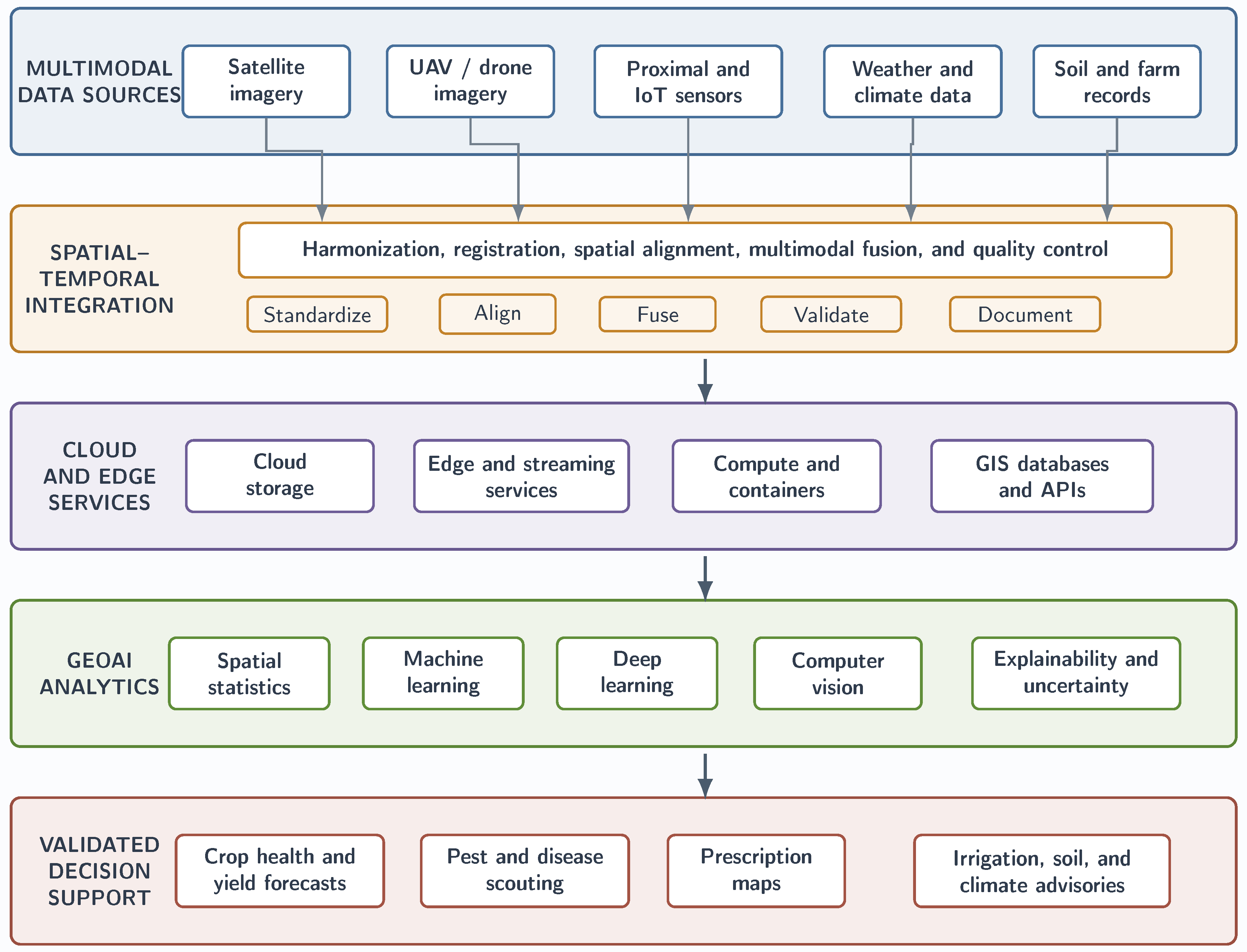
Figure 2.
Screening approach for the selection of literature (PRISMA diagram)
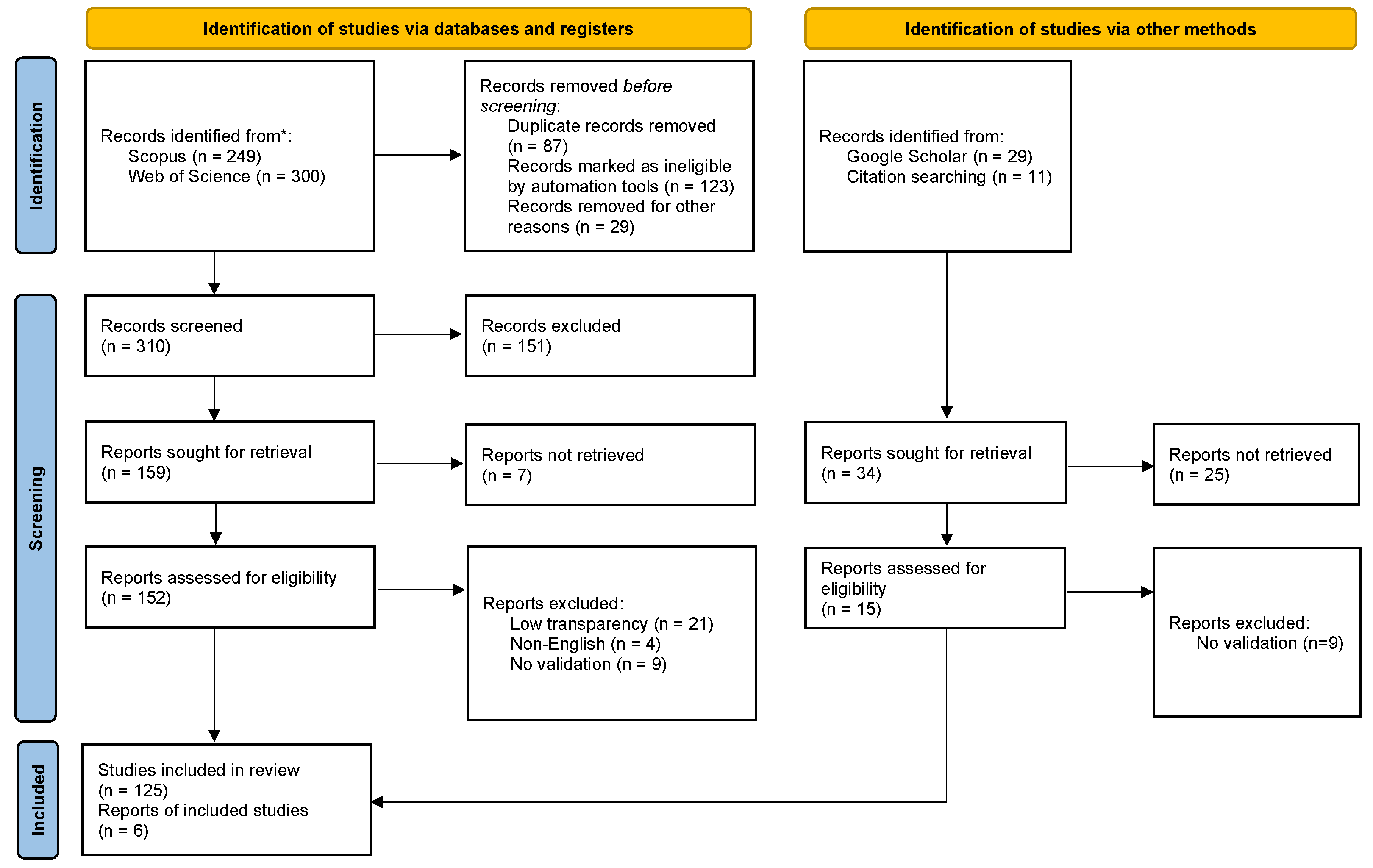
Figure 3.
Generalized multisource, cloud-native GeoAI processing pipeline for precision agriculture. Satellite and UAV imagery, proximal and IoT sensors, weather and climate records, soil measurements, and farm-management data are ingested, harmonized, analyzed, validated, and delivered as decision-support products. AWS, Azure, Google Cloud, open-source, hybrid, and on-premise services can implement the functional stages shown.
Figure 3.
Generalized multisource, cloud-native GeoAI processing pipeline for precision agriculture. Satellite and UAV imagery, proximal and IoT sensors, weather and climate records, soil measurements, and farm-management data are ingested, harmonized, analyzed, validated, and delivered as decision-support products. AWS, Azure, Google Cloud, open-source, hybrid, and on-premise services can implement the functional stages shown.
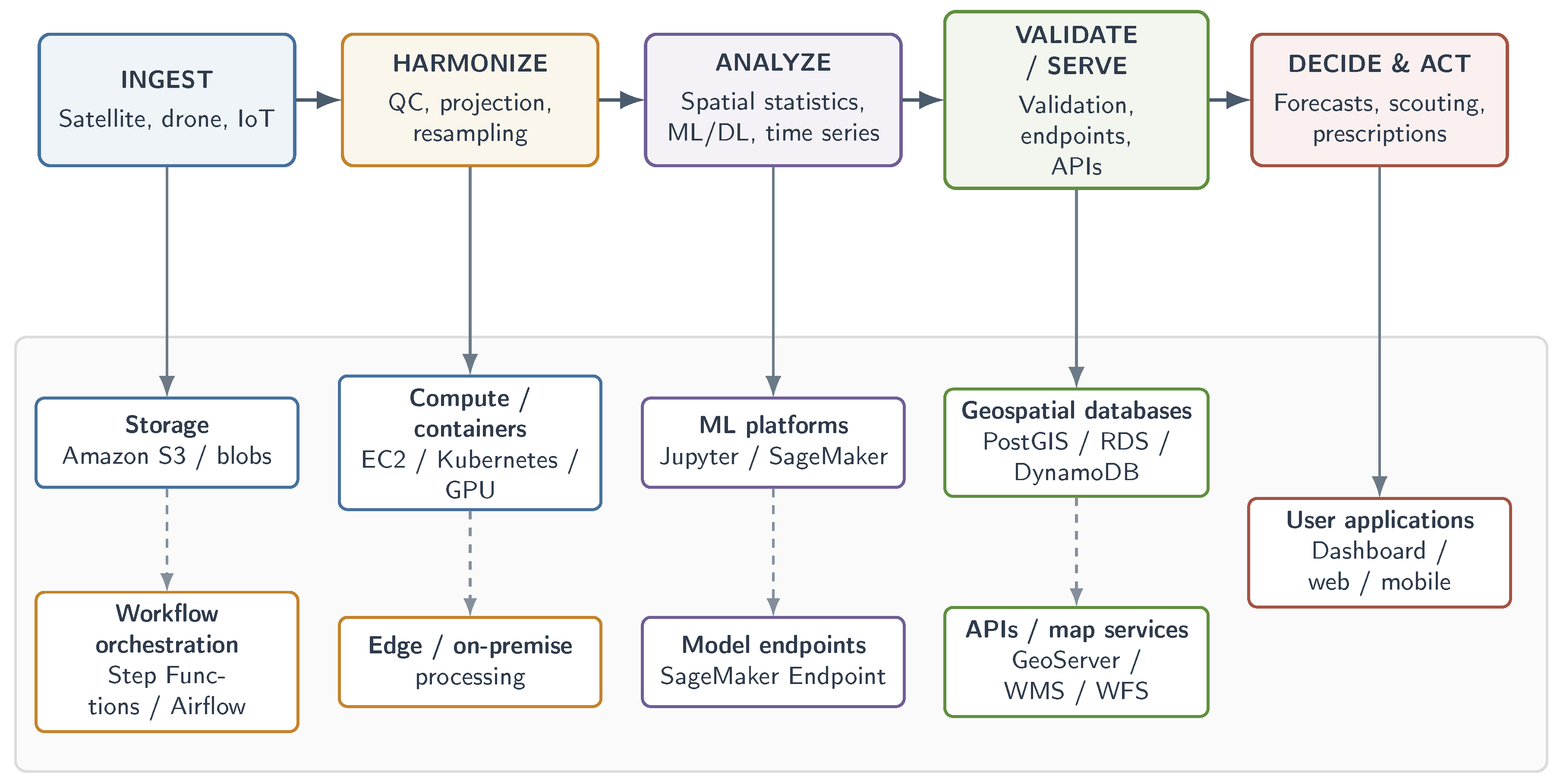

Table 1.
Representative search strings adapted to the GeoAI and precision-agriculture scope of this review.
Table 1.
Representative search strings adapted to the GeoAI and precision-agriculture scope of this review.
| Database | Representative Search String |
|---|---|
| Scopus | TITLE-ABS-KEY(("GeoAI" OR "geospatial artificial intelligence" OR GIS OR "remote sensing" OR satellite OR UAV OR drone OR IoT) AND ("precision agriculture" OR "smart farming" OR "digital agriculture" OR "site-specific management") AND ("machine learning" OR "deep learning" OR CNN OR LSTM OR GRU OR transformer OR "random forest" OR YOLO OR "explainable AI") AND (yield OR crop OR pest OR disease OR soil OR irrigation OR fertilizer OR "decision support")) |
| Web of Science | TS=(("GeoAI" OR "geospatial artificial intelligence" OR GIS OR "remote sensing" OR satellite OR UAV OR drone OR IoT) AND ("precision agriculture" OR "smart farming" OR "digital agriculture" OR "site-specific management") AND ("machine learning" OR "deep learning" OR CNN OR LSTM OR GRU OR transformer OR "random forest" OR YOLO OR "explainable AI") AND (yield OR crop OR pest OR disease OR soil OR irrigation OR fertilizer OR "decision support")) |
Table 2.
Representative crop groups investigated in GeoAI-enabled precision agriculture, highlighting typical applications, principal geospatial data sources, and predominant AI approaches.
Table 2.
Representative crop groups investigated in GeoAI-enabled precision agriculture, highlighting typical applications, principal geospatial data sources, and predominant AI approaches.
| Crop Group | Typical GeoAI Applications | Predominant Geospatial Data and AI Methods |
|---|---|---|
| Wheat [6] | Yield forecasting [6], crop growth monitoring, drought assessment, and climate-sensitive production analysis [28]. | Satellite imagery [6], weather observations, vegetation indices, IoT sensing, temporal deep learning (LSTM/GRU), and ensemble machine learning [28]. |
| Maize (Corn) [64] | Yield estimation [10,65], disease detection [30], management-zone delineation [10], nutrient assessment, and seasonal crop mapping [64]. | Satellite and UAV imagery [64], proximal soil sensing [10], time-series analysis [64], Bayesian neural networks [65], CNNs [30], and Random Forest models [10]. |
| Rice [66] | Crop monitoring [66], soil nutrient prediction [29], irrigation management, smart farming [66], and production forecasting. | Multispectral remote sensing [29], environmental covariates [29], GIS, machine learning [66], and GeoAI-based soil analysis [29]. |
| Potato [7] | Yield prediction [7], cultivar monitoring [7], canopy characterization, quality assessment [67], and harvest planning. | High-resolution UAV imagery [7], multispectral sensing [7], deep learning [67], and image-based feature extraction [67]. |
| Fruit trees and specialty crops [62] | Disease diagnosis [39], canopy segmentation [39], fruit detection, stress monitoring, and climate-resilient management [62]. | CNNs, Vision Transformers, YOLO object detection, semantic segmentation [39], UAV imagery, and smart farming systems [62]. |
| Vineyards and perennial crops [68] | Canopy monitoring [7], spatial variability analysis [68], precision irrigation, and digital farm management [68]. | GIS [68], UAV surveys [7], field observations [68], geospatial databases [68], and cloud-based GeoAI workflows. |
| Mixed cropping systems [69] | Resource optimization [36], irrigation scheduling [69], variable-rate management [36], sustainability assessment, and decision support [59]. | Satellite imagery, IoT sensor networks, soil measurements, weather data [69], multimodal data fusion [36], and AI-driven decision-support systems [59]. |
Table 3.
Principal application domains of GeoAI in precision agriculture, including predominant techniques, data sources, and reported outcomes.
Table 3.
Principal application domains of GeoAI in precision agriculture, including predominant techniques, data sources, and reported outcomes.
| Application Domain | Predominant GeoAI Analytical Techniques | Primary Data Sources | Reported Outcomes |
|---|---|---|---|
| Crop yield estimation [28] | Machine learning and ensemble learning [28], temporal deep learning with GRU and LSTM models [6], CNN-based feature extraction [7], and uncertainty-aware crop forecasting [9] | Satellite imagery and IoT observations [6], UAV imagery [7], proximal soil sensing [10], weather observations [9], vegetation indices [15], and management-zone data [10] | Reported improvement in yield prediction accuracy [28], spatial yield variability assessment [10], early risk identification [9], and risk-aware management decisions [72] |
| Pest and disease detection [20] | CNNs [30], Vision Transformers [38], hybrid CNN–Transformer models [39], YOLO and object detection [19], semantic segmentation [39], and severity classification [20] | UAV imagery [19], satellite imagery [20], RGB field images [30], multispectral imagery [20], and crop-monitoring image datasets [49] | Earlier pest and disease detection in reported studies [19], severity estimation [39], spatial outbreak mapping [20], targeted scouting [20], and reduced response time [19] |
| Soil parameter mapping [26] | Random Forest models [26], CNNs [29], Graph Neural Networks (GNNs) [26], satellite-image fusion [41], multimodal learning [40], and environmental-covariate modelling [29] | Remote sensing products [41], field soil measurements [26], proximal sensors [10], terrain attributes [40], environmental covariates [29], and management-zone information [10] | High-resolution soil property mapping in reported studies [40], improved spatial prediction of soil physical properties [41], improved prediction of soil chemical characteristics [29], and support for site-specific soil management [21] |
| Resource optimization [36] | Multimodal data fusion [12], machine learning [37], GIS-based analytics [3], predictive modelling [34], AIoT-enabled management [23], and modular decision-support optimization [34] | Satellite observations [73], UAV imagery [73], IoT devices [8], weather stations [8], soil sensors [71], moisture monitoring systems [63], and multi-sensor field platforms [8] | Optimized irrigation scheduling in reported studies [69], fertilizer recommendation [21], pesticide management [44], reduced input waste [34], and improved water-, nutrient-, and energy-use efficiency [69] |
| Climate adaptation [62] | Localized GeoAI [62], context-aware machine learning [74], geospatial modelling [4], climate-adaptive AI frameworks [62], and remote-sensing-based sustainability assessment [14] | Regional climate datasets [14], soil information [4], crop monitoring data [49], drought indicators [14], remote sensing products [4], and environmental data streams [14] | Improved water-use efficiency in reported studies [69], drought monitoring [14], climate resilience [62], site-specific adaptation [48], and better alignment between precision agriculture and sustainability goals [45] |
| Decision support systems [34] | Multimodal data fusion [12], Explainable AI (XAI) [42], decision-support frameworks [11], digital twins [43], real-time dashboards [31], and interactive recommendation systems [18] | Integrated satellite data [31], UAV data [31], IoT data [31], weather and soil data [11], farm-management data [75], machinery data [11], and sovereign operational datasets [76] | Actionable recommendations in decision-support studies [34], interpretable predictions [42], real-time operational decision support [18], economic optimization [77], and improved transparency for farmer-facing tools [42] |
Table 4.
Frequently employed GeoAI techniques, algorithms, and geospatial data sources in precision agriculture.
Table 4.
Frequently employed GeoAI techniques, algorithms, and geospatial data sources in precision agriculture.
| Category | Most Common Methods or Sources | Typical Role in Precision Agriculture |
|---|---|---|
| Predominant GeoAI Analytical Techniques [2,11,12,86] | Multimodal data fusion [12,31], GIS-based spatial analysis [3,87], real-time and near-real-time processing [15,79], Explainable AI (XAI) [42,88], uncertainty quantification [11,28], and digital twins [43] | Integrating heterogeneous datasets, identifying spatial variability, supporting trustworthy predictions, communicating uncertainty, and enabling timely site-specific recommendations [12,34,52,58] |
| Machine learning and deep learning algorithms [5,37,49] | Random Forest and ensemble models [26,40], CNNs [30,49], RNNs, LSTMs, and GRUs [6,28], Vision Transformers and hybrid CNN–Transformer models [38,39], YOLO/object detection [19,39], and graph-based models [26] | Yield prediction, pest and disease detection, soil mapping, crop classification, canopy and stress monitoring, image segmentation, object detection, and spatial representation learning [18,20,28,41] |
| Geospatial data sources [3,4,12] | Satellite imagery [6,41], UAV imagery [7,19], IoT and proximal sensor networks [8,23], weather and climate observations [6,28], soil measurements [10,26], vegetation indices (NDVI, EVI, LAI) [7,15], and farm-management data [11] | Providing spatial, temporal, and field-scale information for model training, validation, monitoring, forecasting, prescription mapping, and decision support [10,34,40,49] |
Table 5.
Key terminologies and overview of GeoAI-related concepts in precision agriculture.
| Category | Key Term | Specific Techniques | Overview and Role in Precision Agriculture |
|---|---|---|---|
| GeoAI framework | GeoAI framework | Multimodal fusion, GIS, spatial analytics, AI, and decision support | Integration of geospatial data, remote sensing, GIS, and AI methods to transform agricultural observations into spatially explicit predictions, prescriptions, and decision support [2,61,115,116]. |
| Multimodal data fusion | Early, intermediate, and late fusion; feature alignment; spatiotemporal fusion | Combining satellite, UAV, IoT, soil, weather, and management data to improve model robustness and capture complementary spatial and temporal signals [12,35,119,121]. | |
| Explainable AI (XAI) | SHAP, LIME, Grad-CAM, surrogate models, and attention visualization | Methods that make model outputs interpretable for agronomists and farmers, improving trust in recommendations for irrigation, fertilization, scouting, and risk assessment [42,88,111]. | |
| Digital twins | Data assimilation, simulation, scenario analysis, and virtual field models | Virtual representations of agricultural systems that mirror field conditions and support simulation, forecasting, and management testing before action in the field [24,43,110]. | |
| Uncertainty quantification | Prediction intervals, Bayesian models, ensembles, and uncertainty maps | Estimation of predictive uncertainty so that recommendations can be prioritized, verified, or withheld when confidence is low [11,28,89]. | |
| ML methods | Random Forest (RF) | Bootstrap aggregation, random feature subspaces, and ensemble voting | Ensemble learning method widely used for soil mapping, yield prediction, and tabular agronomic data because it is robust and relatively interpretable [26,29,41]. |
| Support Vector Machine (SVM) | Kernel functions, maximum-margin classification, and epsilon-regression | Supervised method that separates classes or fits regression functions; often used for crop classification, disease detection, and moderate-size remote-sensing tasks [3,30,49]. | |
| Gradient Boosting / XGBoost | Sequential boosted trees, shrinkage, and regularization | Boosted tree methods that improve prediction by correcting errors iteratively; useful for yield estimation, soil property prediction, and decision support [5,10,28]. | |
| k-Nearest Neighbors (kNN) | Distance metrics, neighborhood voting, and local regression | Instance-based method that predicts from nearby samples in feature space; useful for simple baseline models and local pattern matching [5,49]. | |
| Linear and Logistic Regression | Linear predictors, regularization, and logit link | Statistical models used for yield estimation, trend analysis, and binary classification when interpretability is preferred over complex nonlinear structure [9,28]. | |
| Decision Trees | Recursive partitioning, impurity reduction, and rule extraction | Rule-based models that split data into branches; useful for transparent decision logic and as building blocks for ensemble methods [5,28]. | |
| DL methods | CNN | Convolution, pooling, spatial feature maps, and transfer learning | Deep learning architecture that extracts spatial features from imagery; central for crop health monitoring, pest detection, segmentation, and canopy analysis [30,100,101]. |
| RNN, LSTM, GRU | Recurrence, gated memory, and sequence encoding | Sequence models that capture temporal dependence in weather, crop growth, and yield forecasting tasks [9,28,66]. | |
| Vision Transformer | Self-attention, patch embeddings, and positional encoding | Attention-based image model increasingly used for high-resolution agricultural imagery and multimodal representation learning [38,39,49]. | |
| YOLO / Object Detection | Bounding boxes, anchor-free detection, and non-maximum suppression | Real-time object detection family used for identifying pests, weeds, fruits, plants, or field anomalies in drone and field imagery [19,30,39]. | |
| Deep Neural Networks (DNN) | Dense layers, nonlinear activations, and backpropagation | Multi-layer neural models used when the agricultural signal is nonlinear and feature-rich, especially in combined sensing pipelines [5,35,49]. | |
| Data sources | Satellite imagery | Multispectral, hyperspectral, thermal, SAR, and time series | Provides regional and repeated coverage for monitoring crop vigor, drought, land cover, and seasonal change [4,6,13]. |
| UAV imagery | RGB, multispectral, hyperspectral, thermal, and LiDAR | Offers very high spatial resolution for field-level diagnosis, localized stress detection, and scouting support [7,19,73]. | |
| IoT and proximal sensors | Soil moisture, temperature, pH, weather stations, and machinery telemetry | Deliver near-real-time measurements of soil moisture, temperature, pH, and other field conditions needed for precision management [8,23,25,113]. | |
| Weather and climate data | Rainfall, temperature, radiation, forecasts, and drought indices | Provide temporal context for crop growth, water demand, pest pressure, and stress forecasting [9,14,28]. | |
| Vegetation indices (NDVI, EVI, LAI) | Satellite- or UAV-derived spectral ratios and biophysical indices | Derived indicators that summarize canopy condition and are frequently used as model inputs or monitoring outputs [6,15,67]. | |
| Farm-management data | Planting, irrigation, fertilization, harvest, and machinery logs | Operational records such as planting, irrigation, fertilization, and machinery logs that improve contextual modeling and prescription design [11,27,34]. |
Table 6.
Evidence pathways linking GeoAI capabilities to agricultural outcomes.
| Outcome Area | GeoAI Contribution | Interpretive Insight |
|---|---|---|
| Productivity and forecasting [28] | Multisource yield prediction [28], crop-growth monitoring [7], early stress detection [9], and spatial prioritization of scouting and intervention [10]. | Benefits may be strongest when temporal remote sensing [6] is combined with weather [9], soil [10], and management covariates [7] rather than treated as a stand-alone image-classification task [51]. |
| Input and water efficiency [36] | Precision irrigation [22], variable-rate fertilization [21], optical sensing [70], and targeted pesticide or nutrient application [91]. | Efficiency gains can depend on translating model outputs into implementable prescriptions [34] that account for equipment constraints [93], agronomic thresholds [21], and farmer risk tolerance [99]. |
| Environmental sustainability [45] | Reduced over-application [46], improved water stewardship [22], lower runoff risks [32], and more spatially explicit monitoring of environmental pressure [45]. | Sustainability gains are not automatic; they require life-cycle awareness [32], locally adapted recommendations [62], and safeguards against rebound effects [94] or poorly calibrated interventions [95]. |
| Decision support and adoption readiness [34] | Dashboards [18], digital twins [43], alert systems [31], prescription maps [34], explainable indicators [42], and cloud–edge workflows for timely management [80]. | Operational value can depend on trust [56], latency [79], usability [18], validation [51], and integration with existing advisory and machinery systems [24]. |
Table 7.
Application-to-deployment synthesis of GeoAI in precision agriculture.
| Domain | GeoAI Contribution | Deployment Insight |
|---|---|---|
| Yield and crop monitoring [2] | Fusion of satellite data [6], UAV observations [7], weather information [9], soil covariates [10], cultivar data [7], and management-zone information [10] for yield forecasting, stress detection, and crop monitoring [28]. | Performance may improve when temporal dynamics [6] and ground observations [89] are included, especially for risk-aware planning [28] and within-field management [51]. |
| Pest and disease detection [20] | CNN models [30], Transformer architectures [39], object-detection workflows [19], and segmentation models [39] for symptom identification, severity assessment, and scouting prioritization [20]. | Operational reliability typically requires field validation [20], transferability testing [78], and robustness to lighting [100], phenology [49], cultivar differences [101], and background variation [19]. |
| Water, nutrients, and soil [36] | Irrigation scheduling [22], variable-rate inputs [21], soil-property mapping [29], soil-moisture estimation [25], and fertility assessment using multimodal sensing [26]. | Recommendations may be most useful when calibrated to agronomic thresholds [70], equipment constraints [93], soil heterogeneity [113], and farmer risk tolerance [99]. |
| Soil intelligence [26] | Fusion of field samples, proximal soil sensing, terrain attributes, satellite imagery, and environmental covariates for soil-property and soil-quality mapping [29,41]. | Transfer to new fields requires ground calibration, spatially blocked validation, uncertainty estimates, and management interpretations that agronomists can use [51,89]. |
| Climate adaptation [62] | Integration of weather and climate projections, drought indicators, soil and crop observations, and socio-economic context for risk monitoring, crop zoning, and climate-smart advisories [14,47]. | Operational value depends on local vulnerability, seasonal updating, connectivity, affordability, and explicit evaluation of resilience outcomes [54,108]. |
| Decision support and governance [34] | Dashboards [18], digital twins [43], prescription maps [34], cloud–edge processing [80], XAI [42], uncertainty estimates [11], and secure data-sharing mechanisms [109]. | Adoption can depend on usability [18], latency [79], privacy [56], ownership clarity [57], cybersecurity [110], extension support [33], and demonstrated economic value [112]. |
Disclaimer/Publisher’s Note: The statements, opinions and data contained in all publications are solely those of the individual author(s) and contributor(s) and not of MDPI and/or the editor(s). MDPI and/or the editor(s) disclaim responsibility for any injury to people or property resulting from any ideas, methods, instructions or products referred to in the content. |
© 2026 by the authors. Licensee MDPI, Basel, Switzerland. This article is an open access article distributed under the terms and conditions of the Creative Commons Attribution (CC BY) license (http://creativecommons.org/licenses/by/4.0/).
Copyright: This open access article is published under a Creative Commons CC BY 4.0 license, which permit the free download, distribution, and reuse, provided that the author and preprint are cited in any reuse.