
Submitted:
25 June 2026
Posted:
29 June 2026
You are already at the latest version
Abstract
(1) Background: As a critical landscape node in urban roads, the pedestrian refuge island is a key challenge for plant configuration; (2) Methods: This study investigated plant applications on pedestrian refuge islands in spring and winter, using the NCS color system and diversity indices to analyze the spatiotemporal characteristics of their plant communities; (3) Results: A survey of 17 traffic islands identified 53 plant species, comprising 27 in the herb layer, 15 shrubs, 8 trees, and 3 vines. For color diversity, the respective layers had 41, 29, 14, and 6 standard colors. Leaf color values showed seasonal variation: warm-toned in spring and cool-toned in winter. Quantitative characteristics and α-diversity indices of the plant community decreased progressively from the herb layer through the shrub layer to the arbor layer. The community’s Whittaker index (6.527) was lower than the mean species richness (7.71), while the Jaccard similarity coefficient decreased as the distance between quadrats increased; (4) Conclusions: Urban pedestrian refuge islands formed a vegetation landscape characterized by vibrant coloration and distinct seasonal dynamics by enhancing horticultural plant diversity. These patterns of diversity were significantly shaped by human disturbance and urbanization.
Keywords:
pedestrian refuge islands
; NCS color value
; quantitative characteristics
; alpha diversity index
; beta diversity index
; seasonal phase color
1. Introduction
As urbanization intensifies, roadside green spaces are becoming increasingly vital for conserving urban biodiversity, enhancing ecosystem services, and elevating urban landscape aesthetics [1]. Pedestrian refuge islands lie at road intersections where pedestrians and vehicles converge, functioning as landscape nodes within road ecological corridors and integrating traffic guidance with flower border aesthetic appreciation [2]. Plant communities, key components of pedestrian refuge island landscapes, not only reduce intersection accident risks by calming traffic and lowering vehicle speeds [3], but also boost biodiversity in roadside greenery [4,5], ultimately allowing these islands to stand as distinctive punctuation marks in the broader linear landscape. In the analysis of plant community diversity, α-diversity primarily focuses on within-community species diversity, while β-diversity quantifies differences in species composition between communities. Together, these two metrics constitute overall diversity and reflect the biological heterogeneity of a given area [6].
Unlike continuous and dynamic road greening landscapes, pedestrian refuge islands are well-designed flower border green areas where pedestrians can pause briefly to rest and admire the scenery [7]. As the most critical influencing factor in the visual environment, plant color constitutes their most direct ornamental feature [8], while plant seasonal variations further confer temporal color characteristics to the landscape [9,10]. Previous studies have indicated that urban road greening, through the combination of flowering, fruit-bearing, or colored-leaf plants with evergreen species, forms green-dominated flower border plant communities featuring distinct color gradations and rich seasonal variations, such communities mark functional zone boundaries and assist with road traffic guidance [2,4,11]. However, the aforementioned studies remain are limited to qualitative color descriptions, and no relevant research has yet addressed the quantitative analysis of plant color in pedestrian refuge islands.
Therefore, focusing on the green spaces of pedestrian refuge islands in Xinyang City, this study integrated field investigations and photographic documentation to analyze the quantitative characteristics of plant communities, diversity indices, and NCS (Natural Color System) color values. It further investigated the spatiotemporal gradients in plant diversity across these refuge islands, with the aim of providing practical references for the greening design of urban pedestrian refuge islands.
2. Materials and Methods
2.1. Urban Overview
Nestled at 31.85°N and 114.08°E, Xinyang straddles China’s North-South geographical boundary and lies within the transitional climatic zone between the Northern Subtropics and Warm Temperate Zone. As a cultural confluence of Chu culture and Central Plains culture, it is acclaimed as “Northern Jiangnan, Southern Northland”. Leveraging its unique geographical advantages and high-quality living environment, Xinyang City earned prestigious national titles, including “China’s only permanently livable city,” “National Excellent Tourist City,” “National Garden City,” and “China’s Most Beautiful City” [12].
2.2. Methods
This study focused on the main urban area of Xinyang City and conducted a field survey of 17 vegetated pedestrian refuge islands at all traffic intersections across Shihe District, Pingqiao District, Yangshan New Area, and Xinyang High-tech Development Zone. Most of these islands were distributed along two urban arterial roads in Yangshan New Area—New 24th Street and New 7th Avenue—and were characterized by a four-plate five-belt configuration (Figure 1). In contrast, Shihe District primarily uses pavement markings rather than raised islands due to the narrowness of its roads.
Considering seasonal phenological variations and color stratification differences of landscape plants, field surveys were primarily conducted in winter (December 2024–January 2025) and spring (April–May 2025). For each pedestrian refuge island, key metrics were documented, including the scientific and common names, species, abundance, coverage, and phenological stages of arbors, shrubs, herbs, and vines. Simultaneously, the spatial configuration, green space area, and vegetation structure of each refuge island were recorded, and photographic documentation of plant foliage, flower, and fruit colors was conducted during both seasons.
2.3. Data Statistical Analysis
2.3.1. Plant Community Quantitative Traits
The importance value (IVi) denotes a comprehensive index reflecting a species’ status and role within a community [6,13], and is calculated using the following formula:
where: RDi: relative density; RCi: relative coverage; RFi: relative frequency; ni: number of individuals of a given plant species; N: total number of individuals across all species; Ci: coverage of the given species; C: total coverage across all species; Fi: frequency of the given species; F: sum of frequencies across all species; mi: number of plots containing the given species; M: total number of plots.
IVi = (RDi+RCi+RFi)/3
RDi(%) = ni/N×100
RCi=Ci/C×100%
RFi=Fi/F×100%
Fi=mi/M×100%
2.3.2. Plant Community Biodiversity Indices
Based on the survey data, six biodiversity indices were calculated: Margalef richness index (DM), Shannon-Wiener diversity index (H), Simpson dominance index (D), Pielou evenness index (J), Whittaker index (βw), and Jaccard similarity coefficient (Cj). The first four indices represent α-diversity [14], while the latter two denote β-diversity [6]. Corresponding calculation formulas are provided below:
where: S is number of plant species; N is total number of individuals across all quadrats; Pi is proportion of the i-th species; ni is abundance of the i-th species; mα is mean number of species per quadrat; j is number of shared plant species between the two green spaces; and a, b are number of plant species in each of the two green spaces, respectively.
DM=(S-1)/lnN
H=-∑i=1s(PilnPi)
D=1-{∑i=1s[ni (ni-1)]}/(N(N-1))
J=H/lnS
βw=S/mα-1
Cj=j/(a+b-j)
2.3.3. Quantitative Analysis of Seasonal Phase Color of Plant Landscape Units
2.3.4. Data Analysis
Microsoft Excel 2021 and Origin 2021 were utilized to plot and analyze the results, while image processing software (e.g., Photoshop) was employed to process and merge color blocks.
3. Results
3.1. Plant Species Composition and NCS Color Attributes of Pedestrian Refuge Islands
3.1.1. Herbaceous Layer
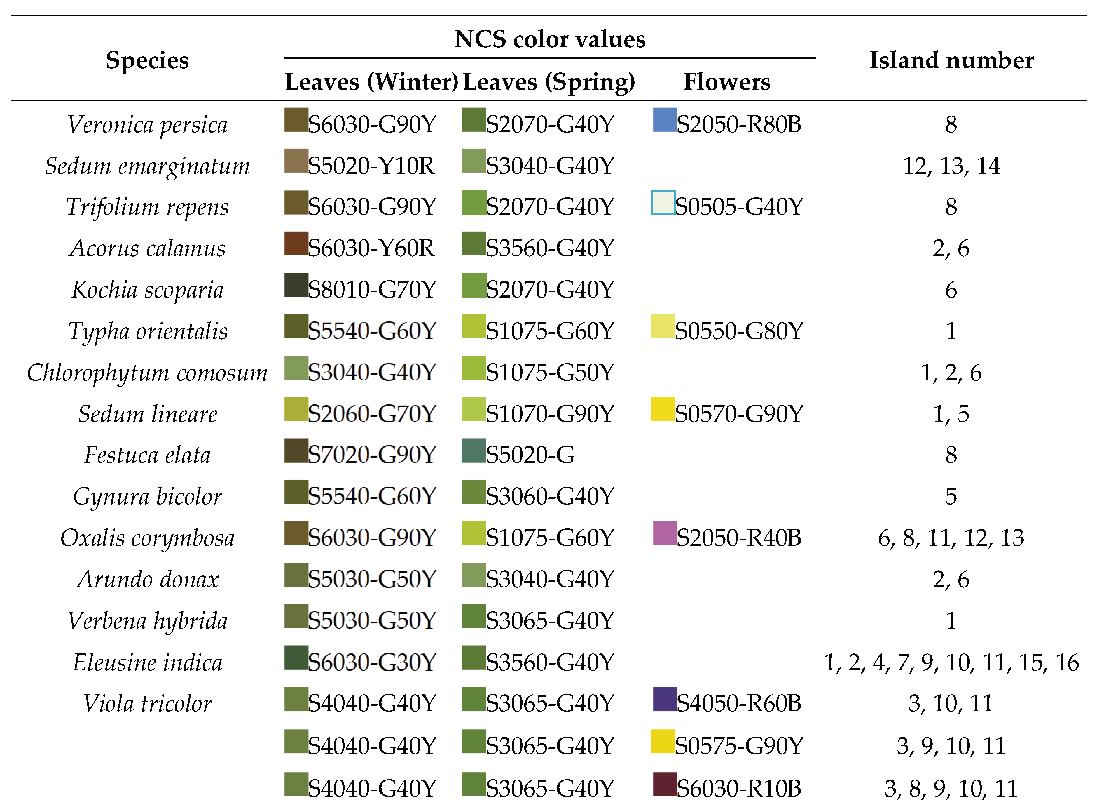
A total of 28 herbaceous species belonging to 27 genera and 22 families were recorded across the 17 pedestrian refuge islands surveyed. Species with an occurrence frequency exceeding 23.5% included Eleusine indica (L.) Gaertn., Dianthus chinensis L., Oxalis corymbosa DC., Viola tricolor L. (Purple morph), Phlox paniculata L., Viola tricolor L. (Yellow morph), Ophiopogon japonicus (L.f.) Ker-Gawl., and Hosta plantaginea (Lam.) Aschers. All these species were perennial herbs except for Eleusine indica, with Liliaceae and Poaceae were identified as the most species-rich families (Table 1).
During the growing season, the leaf color range of the herbaceous layer spanned from S1070-G90Y to S8010-G70Y, encompassing 31 standard colors. Specifically, 17 and 16 standard leaf colors were identified in winter and spring, respectively. Spring leaf colors were dominated by warm-toned greens, whereas winter leaf colors were primarily composed of cool-toned browns. With the exception of Dianthus chinensis and Phlox paniculata, all other herbaceous species exhibited distinct seasonal leaf color dynamics. Regarding flower colors during the growing season, tthe color range extended from S0505-G40Y to S6030-R10B, covering 10 standard colors: 4 yellow, 2 pink, and 1 each of blue, white, purple, and brown. No fruit color values were recorded for the herbaceous layer (Table 1).
3.1.2. Shrub, Tree, and Liana Stratum Vegetation
The shrub layer comprised 15 species belonging to 14 genera within 12 families, all of which were color-leaved plants. Rosaceae was the family with the highest number of species. Species with frequency greater than 23.5% included Loropetalum chinense var. rubrum, Ligustrum × vicaryi, Berberis thunbergia and Nandina domestica (Table 2). During the growing season, the leaf color range of the shrub layer spanned from S1060-G50Y to S7020-G90Y, encompassing 24 standard colors, whereas 13 and 11 standard leaf colors were recorded in winter and spring, respectively. Spring foliage exhibited warm-toned color values, including yellow-based greens, peachy pinks, and orange-red series. while winter foliage displayed cool-toned color values, such as a shift toward desaturated grays, cool-toned browns (e.g., taupe or espresso), and deep, blue-based reds. The flower color range of the shrub layer extended from S0505-G40Y to S3555-R60B, covering 5 standard colors. Fruit color was represented by a single standard color, S8010-R50B (Table 2).
Eight plant species were identified in the arbor layer, and Podocarpus macrophyllus exhibited the highest utilization frequency at 17.7%. During the arbor layer’s growing season, its leaf color ranged from S2070-G40Y to S6520-G, covering 13 standard color specifications. Notably, the number of leaf color values in spring (7) exceeded that in winter (6). Flower color was solely restricted to the specification S1030-R10B, while no fruit color values were documented (Table 2).
The vine layer comprised three plant species. During the vine layer’s growing season, its leaf color ranged from S3020-G30Y to S7010-G30Y, including six standard colors, with green-series color values predominant. Flower color was restricted to a single standard color (S3555-R60B), while no fruit color values were recorded (Table 2).
3.1.3. Quantitative Evaluation of Seasonal Phase Colors in Landscape Units
Overall, 114 and 165 color types were identified in pedestrian refuge islands during winter and spring, respectively. Across vertical strata (arbor: shrub: herb), color richness exhibited ratios of 2:53:59 (winter) and 2:71:92 (spring), with chromatic diversity predominating in the lower vegetation layers in both seasons (Figure 2). Seasonal vertical variations in color richness were assessed across all pedestrian refuge islands. Islands 9, 12, and 13 exhibited high color richness in the herb layer, with 12, 10, and 14 color taxa in spring, respectively, declining to 9, 8, and 10 color taxa in winter. In contrast, Islands 7, 8, and 10 displayed greater color richness in the shrub layer than the herb layer, with shrub-to-herb color richness ratios of 6:1, 6:1, and 11:5 in spring, and 4:1, 4:1, and 8:4 in winter. Additionally, Islands 1, 3, 4, and 5 showed substantial seasonal fluctuations, with winter color taxa declining by more than 56% relative to spring values. Notably, Island 5 exhibited the most pronounced seasonal variation, with color types decreasing from 4 in spring to 1 in winter.
3.2. Quantitative Characteristics
Plant community abundance surveys indicated that, with the exception of Island 17 (shrub layer only), the remaining 16 pedestrian refuge islands were dominated by herbaceous plants, which accounted for more than 86.37% of the relative density. The shrub layer’s relative density ranged from 0.06% to 7.06%, whereas that of the arbor layer consistently remained below 0.49% (Figure 3a). In the herb-shrub bilayer structure, Islands 1, 3, 9, 12, and 13 exhibited higher relative coverage in the herb layer than in the shrub layer, whereas the opposite pattern was observed for Islands 7 and 8. In the three-tier tree–shrub–herb structure, four of the five islands (Islands 2, 14, 15, 16; excluding Island 11) exhibited relative cover among strata in the order: herbaceous layer > arbor layer > shrub layer (Figure 3b). Summing plant relative frequencies across all islands revealed that the ranges of the herbaceous, shrub, and arbor layers were 6.38%–28.37%, 1.42%–12.77%, and 0.71%–3.55%, respectively (Figure 3c). IVi analysis across all plots revealed that, except for Island 17, the other 16 islands followed the hierarchy: herbaceous layer > arbor layer > shrub layer > vine layer. Notably, Dianthus chinensis in Island 16 exhibited the highest IVi value, reaching 54.67% (Figure 3d).
3.3. α Diversity
Centered on the municipal government, a radial gradient survey of the surrounding areas revealed that the DM of pedestrian refuge islands had increased. All islands incorporated in this study exhibiting a DM greater than 1 were distributed along 24th New Main Street (Figure 4a, b).
The maximum values of the H, DM, and D among plant communities on pedestrian refuge islands in Xinyang City were 2.12, 1.81, and 0.74, respectively, all occurring at the intersection of New 24th Main Street and North Ring Road (National Highway 312). In addition, Islands 9, 12, 14, and 15 exhibited favorable α diversity, with H and DM exceeding 1.00 and D above 0.50 (Figure 4a, c, e), and additionally displayed high herbaceous plant diversity, species richness, and dominance (Figure 4b, d, f). Although Island 2 exhibited a tree-shrub-herb multi-layered community configuration, each layer contained only a single plant species. Consequently, its H, DM, and D all reached their minimum values (Figure 4a, c). Notably, despite featuring single-layer herbaceous or shrubby configurations, Islands 5, 6, and 17 exhibited DM < 0.30, H > 0.73, and D > 0.50. In contrast, Island 10, a multi-layered community consisting of trees, shrubs, herbs, and vines, exhibited a high DM of 1.97 yet had H and D below the mean values. According to the J, Island 5 (single-layer herbaceous configuration) exhibited the highest value of 0.998, whereas Island 2 showed the lowest value of merely 0.03 (Figure 4g). Analysis of J across community strata revealed that all pedestrian refuge islands exhibited a consistent hierarchy: herbaceous layer > shrub layer > arbor layer (Figure 4h). J values ranged from 0.998 (Island 5) to 0.22 (Island 10) for the herbaceous layer, 0.67 (Island 17, a single-layer shrub configuration) to 0.02 (Island 16) for the shrub layer, and 0.05 (Island 10) to 0.01 (Island 16) for the arbor layer.
3.4. β Diversity
3.4.1. Whittaker Diversity
Based on the βw formula, βw for plant communities in this study ranged from 0 to 16, with a value of 6.527 (Table 3) — indicating a moderate level. Notably, βw was lower than the average number of species per island (7.71), which reflects a relatively high number of common species among islands. Meanwhile, βw for each community layer decreased sequentially in the order of herbaceous layer > shrub layer > arbor layer, with all these indices exceeding the mean number of species for their respective layers across all islands.
3.4.2. Jaccard Similarity Coefficient
Among the 17 surveyed pedestrian refuge islands, most pairwise Cj values ranged from 0 to 0.2. The Cj values decreased with increasing inter-island distance, though marked regional similarity was noted (Table 4). Specifically, Islands 7-8 and 14-15 exhibited 100% Cj (complete similarity). All pairwise combinations of Islands 3-6, as well as Islands 14-16 and 15-16, demonstrated high similarity (≥0.50). For the island pairs 12-13 and 14-17, the Cj values were 0.33 and 0.30, respectively, indicating moderate similarity. Furthermore, Islands 5 and 17 shared no common species with the other surveyed islands, resulting in a Cj of 0 in all pairwise comparisons involving these two islands.
4. Discussion
4.1. Pedestrian Refuge Islands Enhance Urban Landscape Species Diversity
Fifty-three plant species (51 genera, 42 families) were utilized in 17 pedestrian refuge island plots within Xinyang’s urban core (Table 1 and Table 2). This exceeded the 39 species documented in 20 such islands in Zhengzhou City [4] yet fell slightly short of the 71 species recorded in 31 islands in Guangzhou City [7]. Additionally, the Whittaker index (Table 3) indicated a high degree of species overlap among islands, suggesting that while Xinyang’s pedestrian refuge island vegetation exhibits relatively high diversity, it also reflects constraints on and preferences in plant selection. Herbaceous plants accounted for 53.4% of all species (Table 1) and dominated most islands in terms of quantitative traits (Figure 1) and α-diversity (Figure 2)—a proportional representation that far exceeds the proportion of herbaceous species in Xinyang’s common urban landscape flora [12]. This plant arrangement accentuated the linearity of the outer edges of pedestrian refuge islands, creating a spatial pattern characterized by smooth lines, spaciousness, and staggered distribution, thus eliminating “sight distance blind zones” for both pedestrians and drivers [2]. However, compared with the abundant wild herbaceous plants [13] and woody climbers [16] native to Xinyang region, pedestrian refuge island planting schemes rely excessively on exotic species; spontaneously occurring species within these islands were likely removed as “weeds”. This obscures regional characteristics and compromises the biodiversity and sustainability of refuge island landscapes [17,18]. Although only 8 arbor species were utilized (Table 2), most were formatively trained via binding, shaping, and pruning. When integrated with vines, these plants form a three-dimensional, spatially well- distributed, and staggered landscape—alleviating the issue of “uniform streetscapes” and enhancing Xinyang’s previously monotonous road greening [2]. In addition, pedestrian refuge islands were managed with greater refinement than other urban green space areas, providing natural habitats for the propagation of local endangered species (e.g., Shaniodendron subaequale and Emmenopterys henryi).
4.2. Plant Communities on Pedestrian Refuges Foster Distinctly Colored Seasonal Landscapes
Seasonal plant color constitutes the most dynamic ornamental element in urban landscape architecture [19]. The spring and winter plant landscapes of the 17 pedestrian refuge islands surveyed in this study were dominated by green hues, with a relatively limited range of color categories and a notable lack of blue-purple and orange tones (Table 1 and Table 2). This was also a prevalent predicament in landscape color application across numerous northern cities [9,10]. Although a single hue can generate a diverse yet cohesive plant color landscape through variations in shade and light intensity, alleviating visual fatigue [8,15], pedestrian refuge islands- as a unique landscape type- should incorporate plants with striking color contrasts to differentiate themselves from adjacent roadways, thereby fulfilling warning and directional guidance functions [20]. In both spring and winter, vertical color richness exhibited the following sequence: herbaceous layer > shrub layer > arboreal layer (Table 1 and Table 2; Figure 2). This indicated that lower-layer herbaceous plants function as the color palette that shapes the seasonal dynamics of pedestrian refuge island landscapes. However, it is important to note that the frequency of the same ornamental herbaceous species within a single pedestrian refuge island should be reduced to avoid a drastic decline in winter color richness (Figure 2). While woody plants primarily fulfill a structural role, they mitigate seasonal fluctuations in chromatic richness. To address the demand for specific color categories in pedestrian refuge island plantings, efforts should therefore be intensified to explore and promote native wild ornamental grass resources [13]. Furthermore, seasonal variations in landscape color stem primarily from the seasonal growth characteristics of plants’ ornamental traits—i.e., leaf, flower, and fruit coloration [10,11]. For the winter leaf coloration of pedestrian refuge islands, the standard color S6030-G90Y predominated, whereas S2070-G40Y was most frequently used in spring (Table 1 and Table 2; Figure 2). Specifically, the warm seasonal hues of spring plants’ new foliage and blooms enable pedestrian refuge islands’ spring landscapes to evoke positive emotions and enhance aesthetic satisfaction [21].
4.3. Distinct Spatial Characteristics in Plant Community Diversity on Pedestrian Refuge Islands
Since pedestrian refuge island greening occupies road right-of-way, such islands are typically situated in suburban areas with light traffic and wide roadways [20]. However, municipal roads in Xinyang’s old town are narrow and feature pre-existing greenery, and no additional land for greening is available outside the road right-of-way at intersections. Consequently, all pedestrian refuge islands in this study were located in Xinyang’s new urban district (Figure 1). Notably, all high α-diversity plant communities on the study’s pedestrian refuge islands were concentrated along Xinyang’s 24th New Main Street—a new urban development axis and landscape avenue (Figure 4a, c, e). This indicates that designers intentionally configured greater plant species diversity for islands along this avenue, which results in superior plant stratification, species richness, configuration effectiveness, and overall diversity compared to other roads [22]. In particular, the α diversity index of Island 13 at the intersection of National Highway 312 and 24th Avenue was the highest among the 12 pedestrian refuge islands (Figure 4a, c, e), thus serving as a critical platform for showcasing the new urban transportation image and distinct cultural features. Although Island 2 adopted a multi-layered configuration, its α diversity indices were the lowest (Figure 4). This indicates that despite the complex hierarchical structure of its plant community, a relatively simple species composition confers the weakest resistance to external environmental perturbations and the lowest ecological stability [23]. In contrast, Islands 4, 5, 6, and 17 had single-layer herbaceous or shrubby configurations (Table 1 and Table 2), which were characterized by low richness indices (Figure 4a, b) and weak layering. Nevertheless, their composition of multicolored herbs and shrubs with diverse leaf shapes and hues resulted in diversity and dominance indices above the overall average (Figure 4a, c, e), maintaining considerable combinatorial diversity and effective landscape effects. The Jaccard similarity coefficient revealed that plant configuration similarity decreases with increasing distance between islands, with distinct regional high-similarity clusters (Table 4). In practice, heterogeneity often increased with increasing distance [14]. Regionally highly homogeneous islands were primarily located at intersections far from the municipal core (Table 4). This indicates that landscape planting plans for such low-pedestrian-traffic intersection islands are insufficient for conserving human and material resources, resulting in severe homogenization in plant species selection.
5. Conclusions
In Xinyang, the plant communities on urban pedestrian refuge islands demonstrate quantitative stratification, with the herbaceous layer predominating over the shrub and arbor layers. This arrangement creates a vertical landscape where low-growing herbs form the foundational matrix, while shrubs and arbors appear as distinct patches. The representation of native plants is both low proportionally and quantitatively, leading to a lack of distinct regional characteristics. Notably, the pedestrian refuge islands along New 24th Street exhibit exceptional plant α-diversity, exemplifying the city’s evolving transportation landscape. Among these islands, there is a large number of shared species, with those situated farther from the municipal government displaying significant similarity in plant composition. The diversity patterns of these plant communities are predominantly influenced by human disturbance and urbanization. Regarding landscape coloration, green tones dominate in spring and winter; winter colors are subdued, whereas spring colors are vibrant. During the growing season, the foliar and floral colors of the herbaceous layer serve as the primary ornamental features.
Author Contributions
Conceptualization, N.D. and T.M.; Methodology, N.D.; Investigation, F.Z., M.T. and Y.H.; data curation, F.Z., J.L. and S.W,; writing—original draft preparation, N.D.; writing—review and editing, T.M. All authors have read and agreed to the published version of the manuscript.” Please turn to the.
Funding
This research was funded by National Key Protected Wildlife and Plants Conservation Project (Yucai Huanzi [2024] No. 153), and Henan Provincial Science and Technology Key Project (No. 252102110188, No. 252102110327).
Data Availability Statement
The datasets used or analyzed during the current study are available from the corresponding author upon reasonable request.
Conflicts of Interest
The authors declare no competing interests.
References
- Vakhlamova T.; Rusterholz H.P.; Kanibolotskaya Y.; Baur, B. Effects of road type and urbanization on the diversity and abundance of alien species in roadside verges in Western Siberia. Plant Ecol. 2016, 217, 241-252.
- Hu, J.; Chai, H.L.; Zeng, R.J.; Zhao, L.M. Application analysis on urban traffic island flower border. J Heilongjiang Agric Sci. 2018, 28, 85-89.
- An, Z H.; Xie, B.; Liu, Q.Y. No street is an island: Street network morphologies and traffic safety. Transp Policy. 2023, 141: 167-181.
- Wu, D.; Yang, Q.S. Investigation on plant species abundance and landscape architecture analysis of traffic island green space in Zhengzhou city. J Tianjin Agric Sci. 2018, 24, 82-85.
- Molnár, V.A.; Siffer, S.; Molnár, H.A.; Fekete R. Occurrence of the rare plant Sternbergia colchiciflora in an urban environment. Biol Futura. 2020, p. 3.
- Begon, M.; Townsend, C.R.; Harper, J.L. Ecology: From individuals to ecosystems (fourth edition). Hoboken, New Jersey: John Wiley and Sons Ltd. 2021.
- He, X.H.; Weng, S.F.; Feng, Z.J.; Xie, Z.S. The analysis of urban road safety island greening for the Tianhe district of Guangzhou. Guangdong Landsc Arch. 2017, 39, 73-77.
- 8 Shen, S.; Yao, Y.; Li, C. Quantitative study on landscape colors of plant communities in urban parks based on natural color system and M-S theory in Nanjing, China. Color Res Appl. 2021, 47, 152-163.
- Chen, J.J.; Liu, B.G.; Li, R.; Liu, Y.; Li, Y.H. Research on plant configuration based on quantitative analysis of plant community color composition. J Henan Agric Univ. 2019, 53, 550-556.
- Wang, D.Y. Seasonal phase color matching method of ornamental plants in urban landscape construction. Open Geosci. 2021, 13, 594-605.
- Yi, P.R.; Yan, L.J.; Yan, S.X. Resource status and ornamental characteristics of flowering and ornamental fruit plants in Zhengzhou City. J Henan Agric Univ. 2017, 51, 705-710.
- Xiao, J.H. Analysis and development countermeasures of Xinyang city investigation of garden plant species. J Henan For Sci Technol. 2015, 35, 27-30.
- Wu, H.; Wu, Y.P.; Dong, S.J.; Yuan, M.L. Classification, ordination and species diversity of grass community in Lianghekou national wetland park. J Henan Agric Univ. 2020, 54, 499-505+550.
- Qi, R.; Zhou, X.Y.; Li, Z.H.; Ye, Y.Z.; Yuan, Z.L.; Liu, F.Q.; Shao, Y.Z.; Wei DW.; Chen Y. Plant diversity distribution along an urbanization gradient and relationships with environmental factors in urban agglomerations of Henan Province, China. Diversity. 2024, 16, 53.
- Xing, X.; Hao, P.; Dong, L. Color characteristics of Beijing’s regional woody vegetation based on natural color system. Color Res Appl. 2019, 44, 595-612.
- Shi, S.L.; Yan, S.X.; Kong, D.Z.; Wang X. Studies on the wild woody climber resources in Jigongshan National Nature Reserve and their utilization. J Henan Agric Univ. 2001, 38, 360-363.
- Bonthoux, S.; Voisin, L.; Bouché-Pillon, S.; Chollet S. More than weeds: Spontaneous vegetation in streets as a neglected element of urban biodiversity. Landsc Urban Plan. 2019, 185, 163-172.
- Yue, L. The role of native plant diversity and characteristics in the formation of landscape architecture. Mol Plant Breed. 2023, 21, 5183-5186.
- Zhuang, J.W.; Qiao, L.; Zhang, X.; Su, Y.; Xia, Y.P. Effects of visual attributes of flower borders in urban vegetation landscapes on aesthetic preference and emotional perception. Int J Environ Res Public Health. 2021, 18, 9318.
- Xie, Y. Improvement of road traffic function by greening landscape of municipal road node. For Inv Plann. 2019, 44, 217-221.
- Jiang, L.X.; Chen, D.M.; Wei, W.; Lawson, G. Seasonal phase color dynamics and visual aesthetic perception in subtropical wetland parks: A climate-adaptive design framework. Sustainability. 2025, 18, 386.
- Yin, L.F.; Li, W.; Ren, B.B. Plant diversity and its community characteristics of urban greenways of Beijing. J West China For Sci. 2021, 50, 28-34.
- Savard, J.P.L.; Clergeau, P. ; Mennechez G. Biodiversity concepts and urban ecosystems. Landsc Urban Plan. 2000, 48, 131-142.
Figure 1.
Schematic of quadrats’ locations.
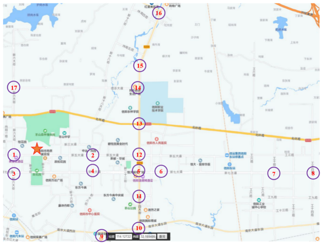
Figure 2.
Seasonal vertical variation of vegetation in pedestrian refuge islands.
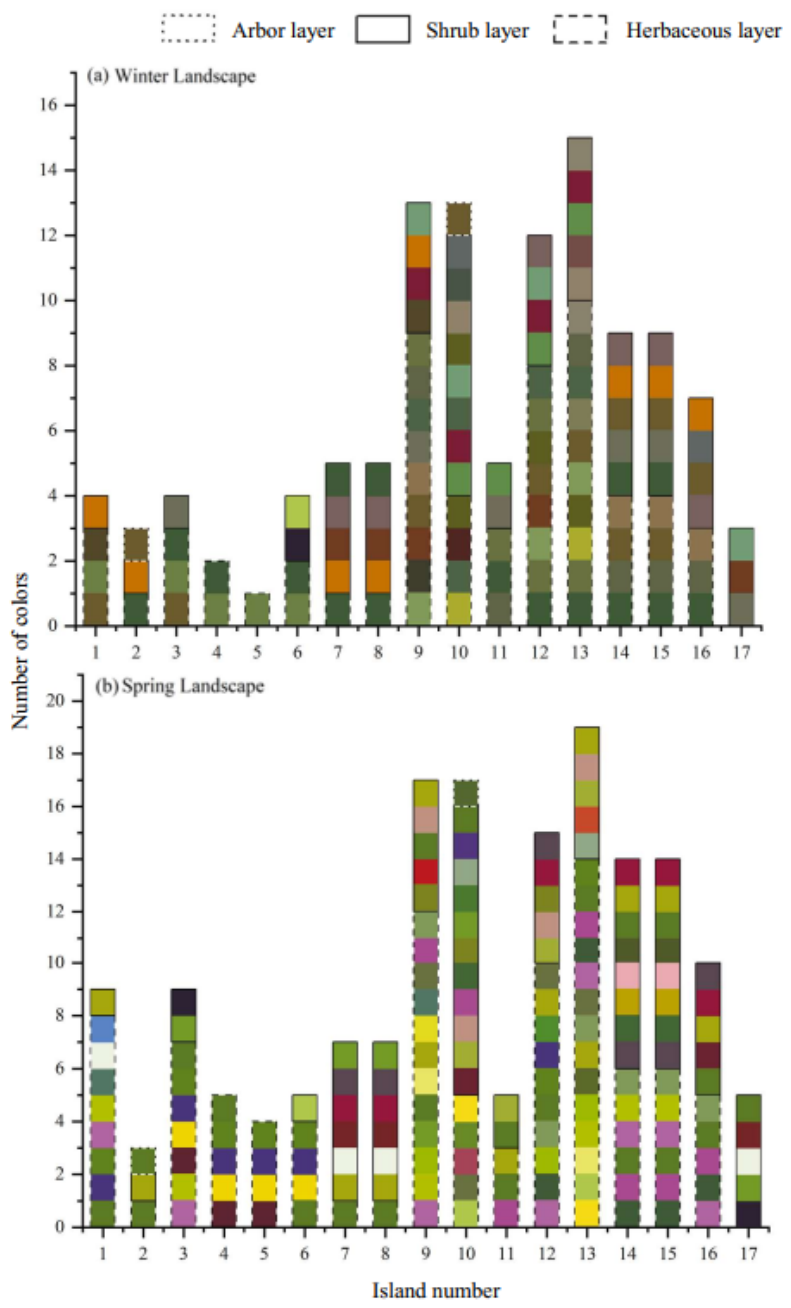
Figure 3.
Quantitative characteristics of different vegetation layers in pedestrian refuge islands.
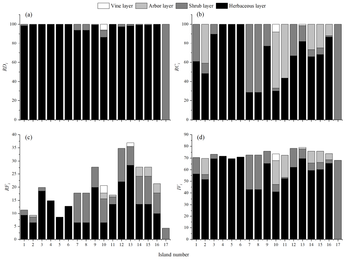
Figure 4.
α-diversity of plants in pedestrian refuge islands.
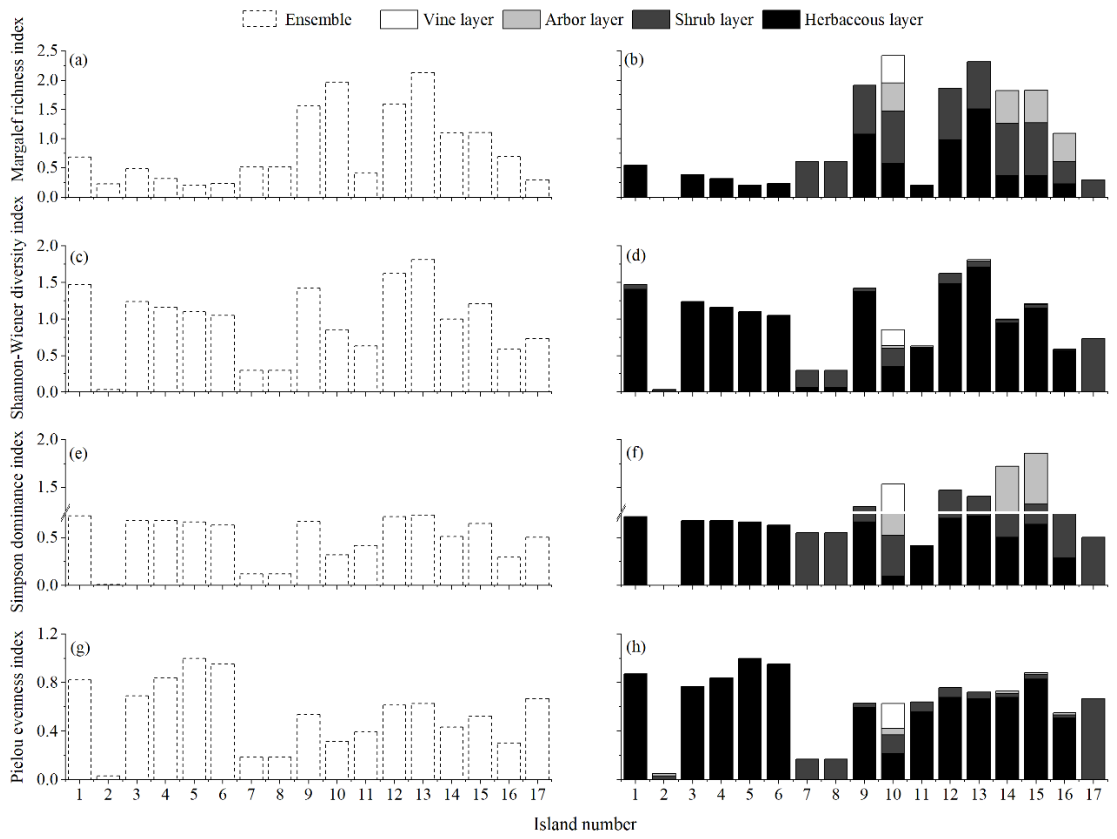

Table 1.
Distribution and NCS color values of ornamental traits of herbaceous plants in pedestrian refuge islands.
Table 1.
Distribution and NCS color values of ornamental traits of herbaceous plants in pedestrian refuge islands.
 |
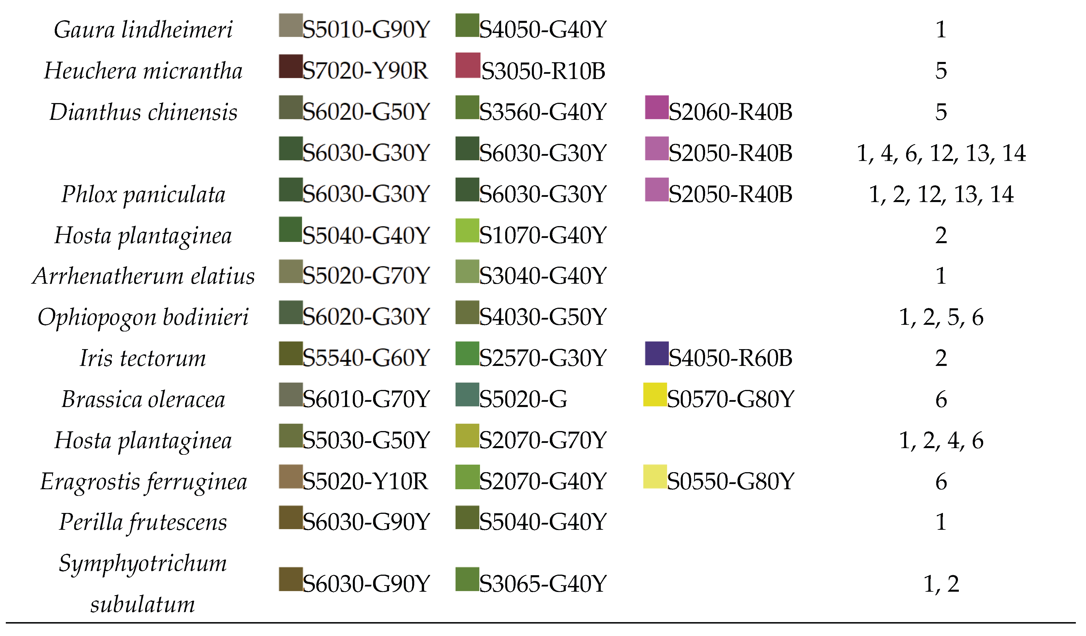 |
Table 2.
Distribution and ornamental trait NCS color values of shrubs, arbors, and vines in pedestrian refuge islands.
Table 2.
Distribution and ornamental trait NCS color values of shrubs, arbors, and vines in pedestrian refuge islands.
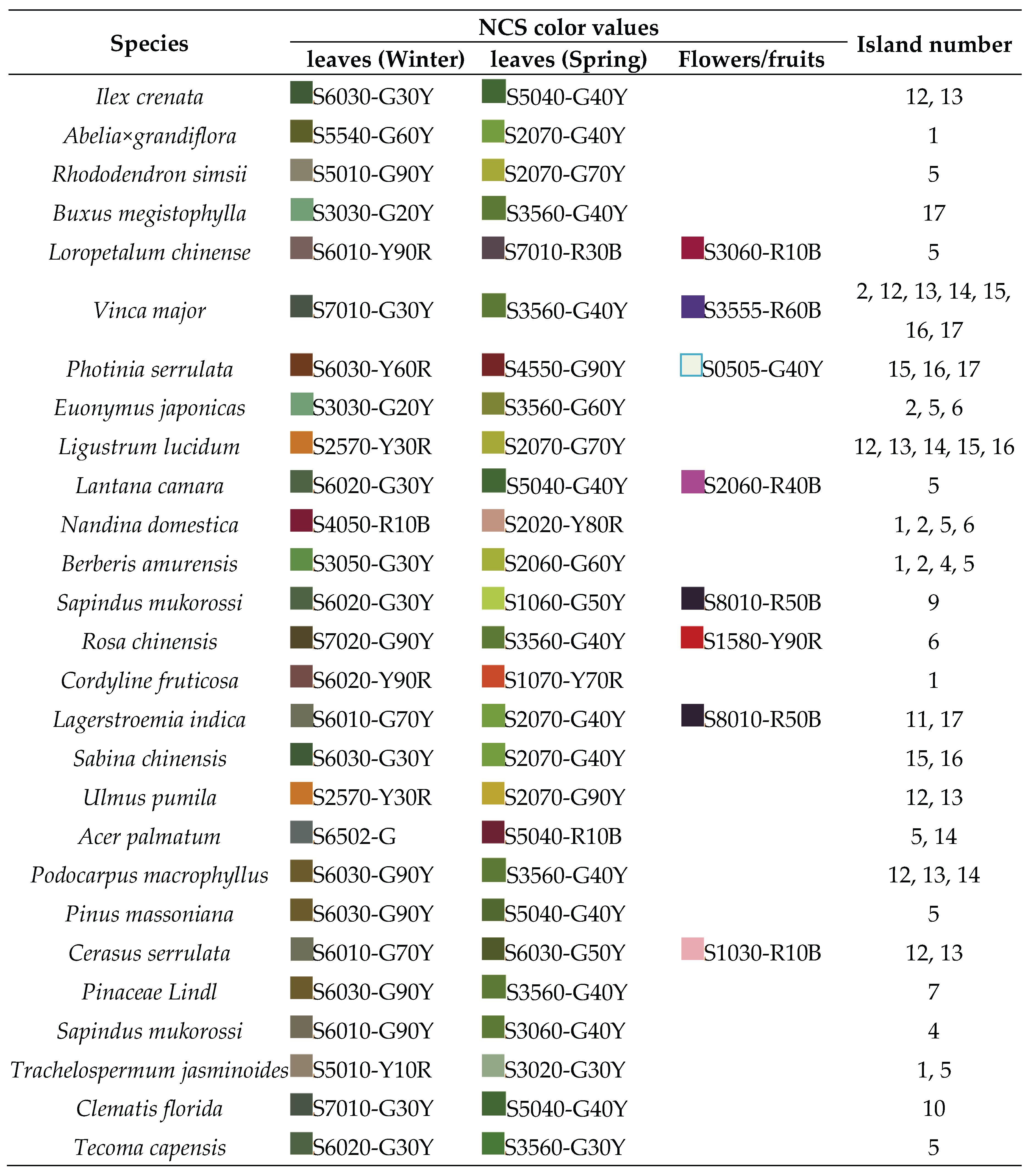 |
Table 3.
Whittaker index of plant communities on pedestrian refuge islands.
| Vertical structure | Average number of species | Number of species | Whittaker index |
| Herbaceous layer | 4.63 | 31 | 5.703 |
| Shrub layer | 3.07 | 18 | 4.861 |
| Arbor layer | 1.67 | 6 | 2.599 |
| Vine layer | 2.00 | 3 | 0.500 |
| Total | 7.71 | 58 | 6.527 |
Table 4.
Jaccard similarity coefficients for plant communities in pedestrian refuge islands.
| Island number | 1 | 2 | 3 | 4 | 5 | 6 | 7 | 8 | 9 | 10 | 11 | 12 | 13 | 14 | 15 | 16 | 17 |
| 1 | 1.00 | 0.13 | 0.20 | 0.11 | 0.13 | 0.13 | 0 | 0 | 0.11 | 0 | 0 | 0 | 0 | 0.07 | 0.07 | 0 | 0 |
| 2 | 1.00 | 0.13 | 0.17 | 0 | 0.20 | 0.14 | 0.14 | 0 | 0 | 0.14 | 0.06 | 0.05 | 0 | 0 | 0 | 0 | |
| 3 | 1.00 | 0.67 | 0.50 | 0.50 | 0.10 | 0.10 | 0.05 | 0 | 0.10 | 0.05 | 0.04 | 0.07 | 0.07 | 0 | 0.13 | ||
| 4 | 1.00 | 0.75 | 0.75 | 0.13 | 0.13 | 0 | 0 | 0 | 0.06 | 0.05 | 0 | 0 | 0 | 0 | |||
| 5 | 1.00 | 0.50 | 0 | 0 | 0 | 0 | 0 | 0 | 0 | 0 | 0 | 0 | 0 | ||||
| 6 | 1.00 | 0.14 | 0.14 | 0 | 0 | 0 | 0.06 | 0.05 | 0 | 0 | 0 | 0 | |||||
| 7 | 1.00 | 1.00 | 0 | 0 | 0 | 0.12 | 0.05 | 0.15 | 0.15 | 0.20 | 0.14 | ||||||
| 8 | 1.00 | 0 | 0 | 0 | 0.12 | 0.05 | 0.15 | 0.15 | 0.20 | 0.14 | |||||||
| 9 | 1.00 | 0.12 | 0.12 | 0.27 | 0.19 | 0.09 | 0.09 | 0.05 | 0 | ||||||||
| 10 | 1.00 | 0.05 | 0.16 | 0.18 | 0 | 0 | 0.05 | 0 | |||||||||
| 11 | 1.00 | 0.19 | 0.21 | 0.07 | 0.07 | 0.09 | 0 | ||||||||||
| 12 | 1.00 | 0.33 | 0.09 | 0.09 | 0.11 | 0 | |||||||||||
| 13 | 1.00 | 0.08 | 0.08 | 0.09 | 0 | ||||||||||||
| 14 | 1.00 | 1.00 | 0.70 | 0.30 | |||||||||||||
| 15 | 1.00 | 0.55 | 0 | ||||||||||||||
| 16 | 1.00 | 0 | |||||||||||||||
| 17 | 1.00 |
Disclaimer/Publisher’s Note: The statements, opinions and data contained in all publications are solely those of the individual author(s) and contributor(s) and not of MDPI and/or the editor(s). MDPI and/or the editor(s) disclaim responsibility for any injury to people or property resulting from any ideas, methods, instructions or products referred to in the content. |
© 2026 by the authors. Licensee MDPI, Basel, Switzerland. This article is an open access article distributed under the terms and conditions of the Creative Commons Attribution (CC BY) license (http://creativecommons.org/licenses/by/4.0/).
Copyright: This open access article is published under a Creative Commons CC BY 4.0 license, which permit the free download, distribution, and reuse, provided that the author and preprint are cited in any reuse.


