Submitted:
05 April 2026
Posted:
07 April 2026
You are already at the latest version
Abstract
Coastal socio‑ecological systems are increasingly exposed to the combined pressures of climate change, land‑use intensification, hydrological alterations and expanding infrastructure networks. These pressures interact across the land–catchment–lagoon–sea continuum, generating complex feedbacks that challenge traditional planning instruments, which remain sectoral and fragmented. The Mar Menor (SE Spain), a semi‑enclosed Mediterranean lagoon affected by intensive agriculture, urbanisation, hydrological modifications and recurrent extreme climatic events, exemplifies this systemic vulnerability. Existing planning frameworks—local urban plans, regional territorial plans, river basin management plans, maritime spatial plans and lagoon‑specific strategies—operate independently, each addressing only a fragment of the system and none integrating climate change as a structuring axis. This article introduces Integrated Spatial Planning (ISP) as a novel territorial–climatic framework designed to overcome these limitations. ISP integrates climate forcing, land uses, catchment processes, lagoon dynamics, marine conditions, critical infrastructures, intermodal and energy corridors and multilevel governance into a single analytical structure. A central component of the methodology is a four‑zone multilevel zoning system that connects municipal, regional, basin, marine and EEZ planning domains within a unified territorial–climatic logic. The ISP matrix is applied to the Mar Menor to produce the first holistic diagnosis of the system. Results reveal strong land–sea–catchment interactions, high climatic exposure, vulnerable infrastructures and structural governance fragmentation. The matrix exposes systemic incompatibilities and vulnerabilities that remain invisible in sectoral planning instruments. The discussion demonstrates how ISP clarifies the roles and responsibilities of each governance level, supports multilevel coherence and integrates critical infrastructures and intermodal corridors into climate‑resilient planning. ISP reframes climate change as the organising principle of territorial planning and provides a replicable, scalable methodology for coastal socio‑ecological systems facing accelerating climate pressures. The Mar Menor case illustrates the urgent need for integrated territorial–climatic governance and positions ISP as a scientifically robust and operationally viable pathway for long‑term adaptation and resilience.
Keywords:
integrated spatial planning (ISP)
; ISP matrix
; marine spatial planning (MSP)
; terrestrial spatial planning (TSP)
; territorial–climatic governance
; climate change adaptation
; land–sea interactions
; coastal socio-ecological systems
; multilevel zoning
; critical infrastructures
; intermodal corridors
; Mar Menor
1. Introduction
Coastal socio-ecological systems are undergoing rapid and profound transformations driven by the combined effects of climate change, land-use intensification, hydrological alterations, demographic pressures and expanding infrastructure networks. These systems are exposed to multiple climatic stressors—sea-level rise, storm surge, extreme precipitation, marine heatwaves and shifts in sediment dynamics—that interact across spatial and temporal scales, producing complex feedbacks and cascading impacts. The accelerating pace of these changes is challenging the capacity of existing planning frameworks to anticipate, manage and mitigate risks in an integrated and coherent manner.
The oceans cover more than 70 percent of the Earth’s surface [1] and provide essential resources and services that sustain human societies and global economies. Ensuring their long-term sustainability requires spatial planning approaches capable of balancing environmental protection with growing social and economic demands. Marine Spatial Planning (MSP) [2] has emerged as a key policy instrument to organise uses of marine space, reduce conflicts and support sustainable development objectives. Promoted internationally by IOC-UNESCO [3] and DG MARE [4], MSP is closely aligned with the Sustainable Development Goals [5] and reinforced by global initiatives such as the UN Decade of Ocean Science [6] and the High-Level Panel for a Sustainable Ocean Economy [7,8]. Through an ecosystem-based approach, MSP addresses fisheries, aquaculture, marine protected areas, renewable energy, climate change adaptation and activities beyond national jurisdiction [9].
Coastal zones represent a critical interface between land and sea, concentrating nearly half of the world’s population [10,11] and a large share of economic activity. These areas are among the most vulnerable to climate-change impacts such as sea-level rise, extreme weather events, flooding and ecosystem degradation. Despite this vulnerability, terrestrial spatial planning frameworks often treat the sea as an external or marginal domain, limiting coordination to the public maritime domain or narrow coastal strips. As a consequence, MSP and Terrestrial Spatial Planning (TSP) have evolved largely as parallel systems, leading to fragmented governance, inconsistent policy objectives and weak integration of climate-adaptation measures across the land–sea system.
These challenges are particularly evident in the Mediterranean region, where national maritime zoning practices vary widely due to diverse legal traditions, administrative structures and planning cultures. This heterogeneity complicates coordination between marine and terrestrial competences and highlights structural gaps in multilevel governance. Existing frameworks such as Integrated Coastal Zone Management (ICZM) [12] and national climate-adaptation strategies have improved coordination in specific contexts, but they remain spatially limited, sector-specific or strongly dependent on national policy settings. They do not fully resolve the need for a coherent planning framework that integrates marine and terrestrial systems across administrative levels and jurisdictional boundaries.
Several studies have attempted to bridge marine and terrestrial planning through integrated coastal governance, land–sea interaction frameworks and cross-boundary spatial analysis. Recent contributions highlight the need to align MSP and TSP through shared data infrastructures, coordinated zoning and climate-informed land–sea governance mechanisms [13,14,15,16,17,18]. These works demonstrate the relevance of integrated approaches but remain either sector-specific, limited to coastal strips, or dependent on national administrative settings. None provide a unified territorial–climatic methodology capable of integrating climate forcing, critical infrastructures, intermodal corridors and multilevel governance across the entire land–catchment–lagoon–sea continuum, which is the gap addressed by the ISP framework proposed in this study.
The novelty of this study lies in the development of Integrated Spatial Planning (ISP) as a unified territorial–climatic framework, together with the ISP matrix as an original analytical tool capable of systematically diagnosing interactions, compatibilities, vulnerabilities and governance fragmentation across the entire land–catchment–lagoon–sea continuum.
At the same time, coastal territories have become increasingly dependent on critical infrastructures and intermodal networks that are themselves vulnerable to climate extremes. Transport corridors, ports, airports, electricity transmission lines, gas pipelines, water transfers and offshore energy infrastructures form the backbone of modern territorial systems, yet they remain largely absent from climate-informed planning. Their exposure to extreme events—flooding, erosion, storm surge, heat stress—creates vulnerabilities that propagate across sectors and governance levels, amplifying systemic risk.
The Mar Menor, located in the Region of Murcia (SE Spain), is a paradigmatic example of this systemic fragmentation. It is a semi-enclosed coastal lagoon influenced by intensive agriculture, urbanisation, hydrological modifications, limited water exchange with the Mediterranean and recurrent extreme climatic events. Over the past decade, the lagoon has experienced severe ecological degradation, including eutrophication, phytoplankton blooms, hypoxia, loss of seagrass meadows and sediment accumulation. These impacts are not isolated phenomena but the result of territorial–climatic interactions that transcend administrative boundaries and sectoral competences. Yet the planning instruments governing the system—PGOU, POTRM, PH Segura, POEM and the Mar Menor Plan—operate independently, each addressing only a fragment of the problem and none integrating climate change as a structuring axis.
In addition, the Mar Menor is embedded within a broader network of strategic infrastructures and intermodal corridors, including the TEN-T Mediterranean Corridor, state road networks, the Port of Cartagena, electricity transmission lines, gas pipelines, water transfers and emerging offshore energy corridors. These infrastructures shape territorial dynamics, influence emissions, condition hydrological behaviour and determine the resilience of the system under climate stress. However, they remain largely absent from existing planning frameworks, which treat them as sectoral assets rather than as integral components of territorial–climatic systems.
In this context, there is a clear need for a spatial-planning methodology capable of overcoming the traditional separation between land and sea, incorporating climate and environmental dynamics and supporting coherent decision-making from local to international scales. This article introduces Integrated Spatial Planning (ISP) as a unified framework designed to address this gap. ISP connects marine areas defined under the United Nations Convention on the Law of the Sea [19] with equivalent terrestrial planning units through a multilevel zoning logic that spans from municipal waters to the EEZ and international domain. The novelty of the approach lies in its explicit integration of climate-change adaptation into spatial-planning instruments, its capacity to align marine and terrestrial policies within a single transferable methodology and its ability to incorporate critical infrastructures and intermodal corridors into territorial–climatic analysis.
By applying ISP to the Mar Menor, this study provides the first holistic territorial–climatic diagnosis of the system and demonstrates the need for integrated governance capable of addressing cross-scale interactions and systemic vulnerabilities. The objectives of the article are therefore threefold: (1) to develop and present the ISP framework as an integrated territorial–climatic methodology; (2) to apply the ISP matrix to the Mar Menor and produce a comprehensive diagnosis of the system; and (3) to discuss the implications of ISP for multilevel governance, climate adaptation and strategic territorial planning.
Figure 1.
United Nations Sustainable Development Goals (SDGs) of the 2030 Agenda. Visual representation of the 17 SDGs that frame the global strategy for environmental, social, and economic sustainability. These goals provide a transversal reference for the integration of marine and terrestrial spatial planning (MSP–TSP), particularly in contexts of urban adaptation to climate change and coastal governance.

2. Materials and Methods
This section reviews the conceptual and policy foundations that support the methodological approach of this study. By examining the evolution of Marine Spatial Planning (MSP) and Terrestrial Spatial Planning (TSP), it clarifies the institutional, legal, and governance frameworks that shape current land–sea planning practices. This background is essential to understand why Integrated Spatial Planning (ISP) is proposed as a unified framework capable of addressing the climate, environmental, and socio-economic dynamics described in the methodology.
2.1. State of the Art of Marine Spatial Planning
Marine Spatial Planning (MSP) has evolved from sectoral ocean management to an ecosystem-based and increasingly climate-informed planning instrument. International organizations such as IOC-UNESCO, the High Level Panel for a Sustainable Ocean Economy, and the Global Partnership for Oceans have been central in promoting sustainable ocean governance, scientific cooperation and policy coherence to address overfishing, pollution, habitat degradation and climate impacts [20,21,22,23,24].
Figure 2.
Legal Boundaries of the Oceans and Airspace [29]. Diagram illustrating the maritime zones defined by the United Nations Convention on the Law of the Sea (UNCLOS), including internal waters, territorial sea, contiguous zone, exclusive economic zone (EEZ), continental shelf, and international waters. These spatial boundaries establish the legal framework for coastal state jurisdiction and are essential for understanding the regulatory scope of marine spatial planning (MSP) in relation to terrestrial planning (TSP) and climate adaptation strategies. Definitions of MSP.

IOC-UNESCO conceives MSP as an integrative framework for ocean governance, understood as the way ocean affairs are managed by governments, communities and stakeholders through law, customs and institutions [25,26]. Key concepts include the coastal zone, the ocean domain, and maritime boundaries (internal waters, territorial sea, EEZ, continental shelf, ABNJ), defined under UNCLOS and related agreements [19,27,28]. These legal spaces delimit the jurisdictional scope of MSP and its relationship with terrestrial planning.
IOC-UNESCO and MSPglobal have also documented the global expansion of MSP processes and plans. Their assessments show a growing number of countries engaged in MSP and an increasing number of approved marine spatial plans at national, subnational and local levels, reflecting the consolidation of MSP as a key governance tool.
Figure 3.
IOC-UNESCO assessments about marine spatial planning status around the world: a. Number of countries/territories engaged in MSP; and b. Number of countries/territories with approved marine spatial plans at national, subnational and/or local level. Source: IOC-UNESCO.
Figure 3.
IOC-UNESCO assessments about marine spatial planning status around the world: a. Number of countries/territories engaged in MSP; and b. Number of countries/territories with approved marine spatial plans at national, subnational and/or local level. Source: IOC-UNESCO.

Multiple definitions of MSP coexist. IOC-UNESCO (2009) defines MSP as a public process for allocating human activities in marine areas to achieve ecological, economic and social objectives; the U.S. National Ocean Council (2013) emphasises science-based planning for multiple uses [30]; and Directive 2014/89/EU establishes a binding framework for EU Member States to organise maritime activities for sustainable development [31]. All stress governance, participation and the balance between growth and conservation, but differ in scope and legal force (global/voluntary vs. domestic vs. binding EU law).
Related concepts include:
Blue economy: the distinction between unsustainable “brown” growth and sustainable “blue” development, with MSP as a key enabler [32].
Ocean multi-use: intentional sharing of space and resources through polyvalent, symbiotic, co-located or sequential uses.
Marine management: sectoral regulation of activities at sea (quotas, technical rules, transport regulations, environmental protection).
IOC-UNESCO’s notion of Sustainable Ocean Planning (SOP) frames MSP within a broader strategic approach that is inclusive, integrated, adaptive, ecosystem-based and knowledge-supported [33]. The SOP Programme under the UN Ocean Decade seeks to achieve 100% sustainable ocean planning, particularly supporting SIDS and LDCs through tools, capacity and a global community of practice [34].
MSP is increasingly recognised as a climate-smart framework, capable of integrating strategic climate objectives into marine sustainable development and environmental policies [35,36,37]. Climate-smart MSP requires robust data, climate literacy and inclusive governance, and can strengthen adaptive capacity by linking marine planning with terrestrial measures for flooding, erosion and extreme events.
Figure 4.
Climate projections for 2100 under +1.5 o C and 2.0 o C scenarios. This figure highlights key oceanic and coastal impacts of global warming, including oxygen loss, acidification, and sea level rise. It identifies vulnerable island states and megacities, reinforcing the need for Integrated Spatial Planning (ISP) to address land–sea interactions and enhance climate resilience. Source: IPCC Special Report on the Ocean and Cryosphere.

Challenges in Incorporating Climate Change Impacts into MSP
Climate Despite significant progress, several structural challenges still limit the full integration of climate change into Marine Spatial Planning (MSP). Climate change affects marine and coastal systems through multiple interacting processes that complicate long-term planning and reduce the effectiveness of MSP as a governance instrument. The literature identifies three main barriers:
Variable impacts: climate change affects sectors, geographies and spatial scales differently, with cumulative effects from human activities [38].
Knowledge gaps and uncertainties: despite efforts to incorporate climate change into spatial scenarios, uncertainties persist due to complex biophysical processes [39], requiring explicit integration of temporal evolution and climate projections [40].
Uneven national responses: adaptation capacities differ widely between developed and developing countries, creating asymmetries in implementation and resilience.
These limitations highlight the need for planning frameworks capable of integrating climate projections, land–sea interactions and multilevel governance structures—elements that are central to the ISP approach developed in this study.
Climate-Smart MSP and Adaptive Capacity
MSP is increasingly recognized as a climate-smart framework capable of embedding climate objectives into marine sustainable development and environmental policies [37]. A climate-smart MSP requires robust data on ecosystem impacts and human uses, climate literacy, and stakeholder knowledge, supported by inclusive design approaches that enable adaptive and dynamic governance.
Crucially, integrated MSP–TSP planning strengthens adaptive capacity by linking land and sea management [41]:
Flooding: joint zoning of terrestrial and marine areas enables coordinated defenses (wetlands, dunes, breakwaters) that reduce flood risks.
Coastal erosion: integrated planning aligns terrestrial land-use restrictions with marine ecosystem restoration, preventing maladaptive urban expansion.
Extreme events: shared governance frameworks improve early warning systems and evacuation routes by connecting terrestrial infrastructure with marine hazard monitoring.
Knowledge-oriented actions (expanding evidence on vulnerable uses, integrating relocation scenarios into MSP) and policy-oriented actions (embedding climate objectives into sustainable development policies through climate-smart MSP and interdisciplinary networks) are essential to operationalize this potential.
Policy Actions in Europe and Spain
At the policy level, the European Union has consolidated MSP as a strategic tool for climate-resilient ocean governance. Directive 2014/89/EU [42] established a framework for maritime spatial planning, transposed in Spain via Royal Decree 363/2017 [43] under Law 41/2010 [44]. This decree approved five maritime spatial plans aligned with the European Green Deal [45], the Paris Agreement [46], the EU Climate Change Adaptation Strategy [47] and the EU Biodiversity Strategy to 2030 [48], developed through inter-administrative coordination and stakeholder participation.
Spain further strengthened MSP with Royal Decree 150/2023 [49], covering five marine regions (North Atlantic, South Atlantic, Strait and Alboran, Levantine-Balearic, Canary Islands) as defined in Law 41/2010 [50]. These frameworks ensure the sustainability of human activities at sea while directly supporting climate adaptation and risk reduction, and provide the institutional basis upon which ISP extends MSP logic toward integrated land–sea climate governance.
Figure 5.
The five marine regions defined by Spain’s Maritime Spatial Planning Plans (POEM). Spatial delineation of the five marine regions established under the POEM framework: Noratlántica, Sudatlántica, Canaria, Levantino-Balear, and Estrecho-Alborán. These regions reflect ecological, socio-economic, and administrative criteria, and serve as the operational basis for implementing MSP in Spain. Their definition is critical for coordinating marine and terrestrial planning processes in the context of climate adaptation and integrated coastal governance. Source: Executive Summary of the POEM. Ministry for the Ecological Transition and the Demographic Challenge.

2.2. State of the Art of Land Planning
Terrestrial Spatial Planning (TSP) is structured through legal and governance systems that organize land uses at national, regional and local levels. Unlike marine space—predominantly public domain—land is largely private, especially in urban areas, while public land is reserved for infrastructures and essential services. Territory is therefore conceived as a resource whose use must be programmed and regulated under legal supervision [51,52,53,54] with planning shaped by legal, political, economic and social criteria.
At the European level, the European Charter for Territorial Planning (1983) and subsequent instruments (European Territorial Strategy, Guiding Principles for Sustainable Development) established principles of balanced regional development, quality of life, responsible resource management and rational land use. Land use planning is conceived as an integrative, interdisciplinary and holistic approach that addresses environmental, social, economic, infrastructural and service-related issues, ensuring legal security, sustainability and territorial balance.

Table 1.
Land Planning. Scope and Approach in Europe. Overview of the hierarchical distribution of land planning responsibilities across governance levels in the European context. The table highlights the macro-level guidelines set by the European Union, the sectoral and infrastructural criteria defined by Member States, and the operational planning frameworks implemented by Autonomous Communities and Local Entities. This structure is essential for understanding the vertical coordination required in terrestrial spatial planning (TSP) and its integration with marine spatial planning (MSP). Source: [55].
| SCOPE | APPROACH |
|---|---|
| European Union | Macro land planning: General criteria and guidelines |
| Member State | Regional policy: Infrastructure of general interest, sectorial criteria |
| Autonomous Community | Land Planning |
| Local Entities | Urbanism (Subject to approval by Autonomous Communities) |
European land-use planning models reflect diverse political and administrative structures but share common principles. Examples include [56]:
- United Kingdom: unitary state with planning responsibilities divided among central government, counties and municipalities; since 1990, emphasis on territorial balance and sustainability.
- France: unitary republic with decentralised powers; regions, departments and municipalities share responsibilities, with local urban planning integrated into broader frameworks [57].
- Germany: federal state where territorial planning is conducted at federal level, implemented by Länder and supported by municipalities and districts; active in European territorial policy [58].
- Spain: decentralised state with 17 Autonomous Communities; the State retains authority over national laws and major infrastructures, while regions and municipalities manage planning; coastal responsibilities are increasingly transferred to autonomous communities.
- Italy: unitary republic with strong regional decentralisation; regions hold exclusive competencies in land and urban planning, while the State retains authority over infrastructures of general interest, cultural heritage and environment [58].
The EU complements these systems through financial and policy instruments such as the European Regional Development Fund (ERDF) [59,60,61,62], aimed at reducing regional disparities and strengthening territorial cohesion and competitiveness.
Land-use planning is implemented through a hierarchy of instruments operating at different levels (state, regional, municipal) [63], including:
- Territorial development plans (regional/municipal strategies),
- Coordination programmes (alignment of public actions with territorial impact),
- Natural and rural land-use plans (protection and enhancement of ecological, agricultural and landscape areas, including specific coastal land-use plans),
- Regional interest actions (exceptional instruments for urgent or strategic development),
- Municipal land-use plans (general urban plans and their development instruments: partial plans, special plans, detail studies, urbanisation projects).
Sectoral legislation (coasts, water, forests, protected areas, roads, railways, airports, energy transport) has hierarchical precedence over urban planning laws and must be integrated into territorial planning [51]. This multi-layered system ensures that territorial organisation balances strategic development with ecological, social and infrastructural considerations, but also contributes to the institutional and legal complexity that ISP must bridge when integrating TSP and MSP into a unified land–sea framework.
Despite significant advances, TSP remains predominantly land-centric and only partially coordinated with marine governance. Existing integrative frameworks such as Integrated Coastal Zone Management (ICZM) [64,65] and Land–Sea Interaction (LSI) [66] approaches have improved coordination at the land–sea interface, but they remain spatially limited, sector-specific or strongly dependent on national administrative settings. They do not fully incorporate climate forcing, catchment-to-coast processes or multilevel governance structures.
This fragmentation—exposed and amplified by climate change—provides the rationale for Integrated Spatial Planning (ISP), a unified territorial-climatic framework that extends the strengths of MSP and TSP while addressing their structural blind spots across the entire land–catchment–lagoon–sea continuum.
2.3. Methodology
2.3.1. Rationale for Integrated Spatial Planning (ISP)
Marine Spatial Planning (MSP) and Terrestrial Spatial Planning (TSP) provide essential but incomplete perspectives for understanding and managing coastal socio-ecological systems. MSP is internationally recognised as a public, science-based process for allocating marine space to achieve ecological, economic and social objectives, operating within the legal boundaries established by UNCLOS, which define internal waters, territorial seas, contiguous zones, exclusive economic zones and international waters [19]. TSP, in parallel, regulates land uses, urban development, infrastructure and environmental protection through legally binding instruments at national, regional and municipal levels [45,46,51,52].
However, as shown in the state-of-the-art review, MSP and TSP continue to function as parallel systems, each constrained by sectoral mandates, fragmented governance and limited integration of climate change. This fragmentation has been widely documented in the literature, which highlights the persistent disconnection between terrestrial and marine planning [67], the need to integrate land–sea interactions (LSI) into MSP [68,69], and the institutional and methodological challenges that hinder coherent land–sea governance [70].
Climate-smart MSP has advanced the incorporation of climate projections, ecosystem vulnerability and socio-economic exposure into marine planning [30,31,32,33,34], but integration remains uneven due to uncertainties, data limitations and institutional disparities. TSP, despite its maturity, rarely incorporates marine dynamics, catchment processes or climate-driven land–sea interactions.
These limitations are particularly evident in coastal areas, where environmental processes such as sediment transport, runoff, erosion, flooding and nutrient exchanges operate across administrative boundaries, and where socio-economic activities such as ports, tourism, fisheries, aquaculture and coastal infrastructure require coordinated land–sea planning. International initiatives—including the MSPglobal Programme [71], PAP/RAC frameworks [72], ESPON territorial analyses [73], UNEP assessments on water quality and catchment pressures [74,75], and regional LSI programmes [76,77]—have contributed to improving coordination, but integration remains partial and strongly dependent on national administrative settings.
Existing approaches, including Integrated Coastal Zone Management (ICZM), have improved coordination but often lack statutory integration with binding planning instruments [65,66,67,68].
To address these gaps, this study adopts Integrated Spatial Planning (ISP) as a unified territorial–climatic framework capable of integrating land, catchments, lagoons, marine waters and the Exclusive Economic Zone (EEZ) under a single methodological structure. ISP builds upon MSP and TSP but incorporates climate forcing, critical infrastructures, intermodal and energy corridors, catchment–lagoon–sea interactions and multilevel governance. This approach aligns with the EU MSP Directive (2014/89/EU), the Water Framework Directive (2000/60/EC), the Floods Directive (2007/60/EC), the EU Strategy on Adaptation to Climate Change and the Spanish National Climate Change Adaptation Plan (ENACC).
Figure 6.
The Cerdá Plan in Barcelona. Historical map of Barcelona and its surroundings, illustrating the urban layout proposed by Ildefonso Cerdà in the mid-19th century. Despite his background as a Civil, Canal and Port Engineer, Cerdà’s visionary plan for the city was conceived with limited integration of the coastal interface, reflecting a historical disconnection between urban development and maritime spatial considerations. Source: City History Museum, Barcelona.

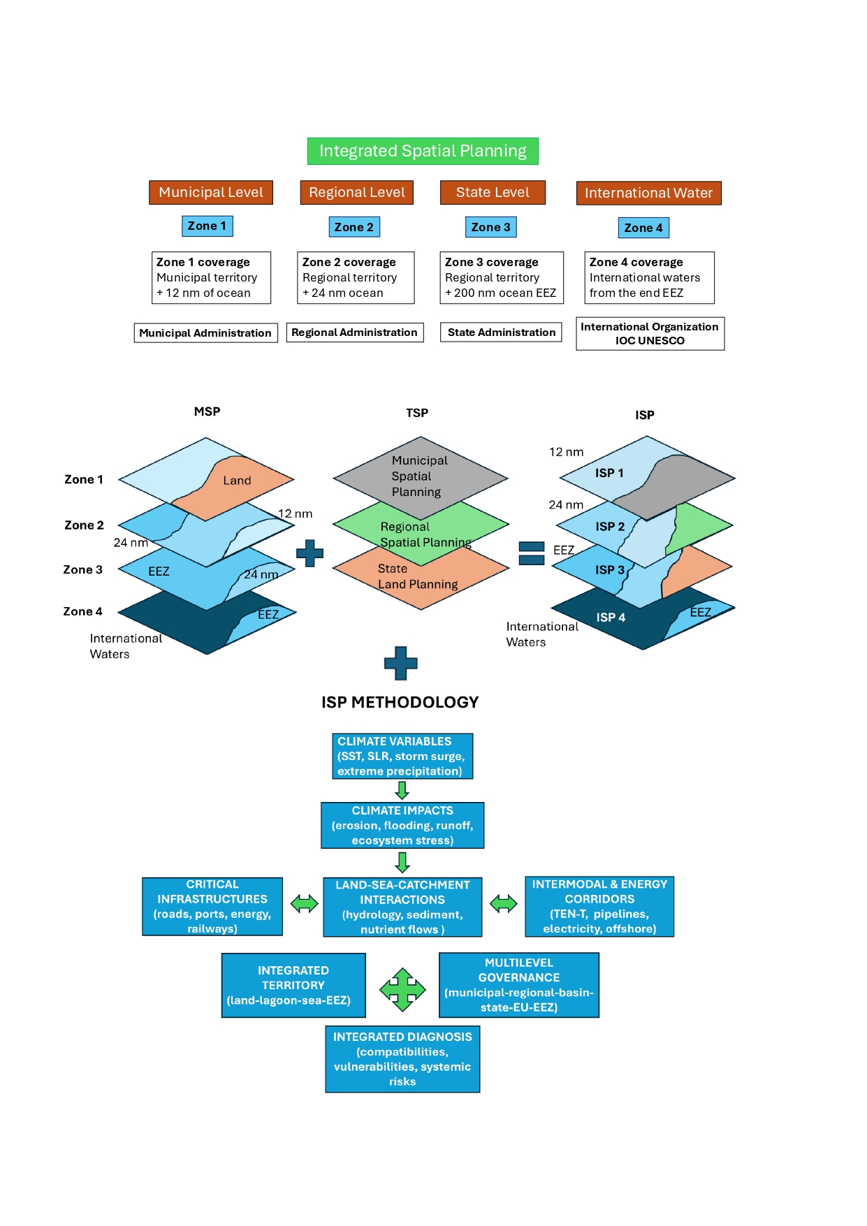
A synthetic representation of the ISP analytical structure is provided in Figure 7, which organizes the methodology into eight interconnected blocks: climate variables, climate impacts, critical infrastructures, integrated territory, land–sea–catchment interactions, intermodal and energy corridors, multilevel governance and integrated diagnosis.
Figure 7.
Integrated Spatial Planning (ISP) analytical structure. Synthetic representation of the ISP framework showing how climate variables, climate impacts, land–sea–catchment interactions, critical infrastructures, intermodal and energy corridors, integrated territory and multilevel governance converge into a unified territorial–climatic diagnosis.

2.3.2. Study Area: The Mar Menor Socio-Ecological System
The Mar Menor is a semi-enclosed coastal lagoon located in the Region of Murcia (SE Spain), connected to the Mediterranean Sea through three inlets. It is influenced by an intensively cultivated coastal plain, a semi-arid climate with extreme precipitation events (DANAs), urban and touristic development, hydrological contributions from the Segura River Basin and limited water exchange with the Mediterranean. This configuration makes the Mar Menor an ideal case study for ISP, as it requires the integration of land, catchment, lagoon, marine and infrastructural processes under climate change.
2.3.3. Documentary Framework for ISP Analysis
ISP does not replace existing planning instruments; instead, it systematically integrates them into a unified territorial–climatic matrix. The following documents constitute the mandatory reference framework for the Mar Menor case:
Municipal Level: PGOU (Cartagena and Surrounding Municipalities)
Provides land-use zoning, urban growth patterns, risk areas, drainage systems, coastal setbacks and local infrastructure networks [78]. Limitations include the absence of climate change integration, catchment processes and marine dynamics.
Regional Level: Territorial Spatial Plan (POTRM)
Catchment Level: Segura River Basin Management Plan (PH Segura)
Includes hydrological resources, runoff, flood risk (PGRI), nutrient loads and catchment pressures [82]. Limitations include the absence of marine dynamics, lagoon processes and coastal climate impacts.
Marine Level: POEM Levantino–Balear
Provides marine zoning, uses (navigation, fishing, conservation, offshore energy) and compatibility rules [83]. Limitations include the lack of integration of catchment inputs, lagoon dynamics, intermodal transport and offshore energy corridors under climate change.
Lagoon Level: Specific Plan for the Mar Menor
Addresses ecological status, nutrient inputs, sedimentation and environmental measures [84]. Limitations include the absence of integration with the full Segura Basin, marine climate, offshore energy and strategic infrastructures.
State Level: Strategic Infrastructure, Energy and Intermodal Planning
Includes the National Road Network, ADIF rail corridors (including the TEN-T Mediterranean Corridor), Ports of the State (Cartagena), AENA airports, REE electricity transmission network, PNIEC, gas pipelines, hydroducts, inter-basin transfers (e.g., Tajo–Segura) and offshore energy and submarine cable corridors. These infrastructures determine territorial structure, emissions, resilience, intermodal connectivity and climate vulnerability [85].
European and International Framework
2.3.4. Construction of the ISP Matrix
The ISP matrix integrates all documentary sources into eight analytical blocks:
- Climate variables (sea-level rise, storm surge, precipitation, runoff, SST, wind, wave climate).
- Climate impacts (coastal flooding, fluvial flooding, erosion, salinisation, ecological degradation).
- Critical infrastructures (transport, energy, water, ports, airports, offshore assets).
- Integrated territory (land uses, marine uses, catchment, lagoon, EEZ).
- Land–sea–catchment interactions (hydrological, sedimentary, ecological, urban, climatic).
- Intermodal and energy corridors (TEN-T, port–rail–road interfaces, offshore energy corridors).
- Multilevel governance (municipal, regional, basin, state, EU, international).
- Integrated diagnosis (compatibilities, conflicts, vulnerabilities, opportunities).
2.3.5. Application of the ISP Matrix to the Mar Menor
The matrix is filled using climate datasets (AEMET [94], Puertos del Estado [93], Copernicus [92]), hydrological data (CHS [82]), ecological data (regional monitoring programmes), land-use and urban planning data (PGOU [78], POTRM [79,80,81]), marine uses (POEM [83]), infrastructure datasets (MITMA [95], ADIF [96], REE [97], Puertos del Estado [93]) and lagoon-specific studies. This produces a territorial–climatic integrated diagnosis of the Mar Menor system.
2.3.6. Multilevel Governance Interpretation
The ISP matrix is then used to determine the responsibilities of each governance level:
- Municipal level: adjust land-use zoning, drainage and coastal risk management.
- Regional level: coordinate land uses, agriculture, ecological corridors and climate adaptation.
- Catchment authority: integrate runoff, nutrients and flood risk with lagoon and marine processes.
- State level: integrate intermodal transport, energy corridors, ports, offshore infrastructures and climate resilience.
- International level: align EEZ uses with climate and energy transitions.
3. Results
The application of the Integrated Spatial Planning (ISP) framework to the Mar Menor socio-ecological system produces the first comprehensive territorial–climatic diagnosis that simultaneously integrates climate forcing, land uses, catchment processes, lagoon dynamics, marine conditions, critical infrastructures, intermodal corridors and multilevel governance. The results are presented in two complementary formats: (1) the complete ISP matrix and (2) a narrative interpretation of each analytical block. A key outcome of the analysis is the confirmation that the four ISP zones operate as superimposed governance layers, each affecting the entire land–sea continuum and enabling climate-resilient planning across scales.
3.1. ISP Zonification: A Superimposed Territorial–Climatic Structure
The ISP framework is structured through a four-zone system that integrates land, catchment, lagoon, marine waters and the Exclusive Economic Zone (EEZ). These zones do not replace one another; instead, they accumulate and overlap, expanding governance responsibilities and climate-adaptation mandates across the same physical territory.
Zone 1: Municipal scale (0–12 nautical miles)
Corresponds to local land-use planning (PGOU) and adjacent internal waters and territorial sea. Results show that municipal planning must extend into the maritime domain to incorporate coastal flooding, shoreline retreat, storm surge and extreme events. Urban development rights and coastal uses must be conditioned by climate scenarios, requiring adaptive planning models.
Zone 2: Regional scale
Includes supra-municipal land-use structures (POTRM), ecological corridors, coastal plans and sectoral strategies. This zone is critical for coordinating infrastructures, managing cumulative environmental effects and aligning agriculture, industry and tourism with adjacent marine uses. It acts as the hinge between national marine strategies and local land-use regulation.
Zone 3: National scale (EEZ)
Covers the Exclusive Economic Zone, where national administrations integrate Marine Spatial Planning (POEM) with state-level terrestrial planning instruments. National transport corridors, port systems, energy transmission networks, offshore infrastructures and communication systems must be addressed jointly across land and sea. Climate-adaptation methodologies must be applied consistently across both domains.
Zone 4: International scale (international waters)
Corresponds to IOC-UNESCO frameworks and UNCLOS governance. Planning focuses on maritime routes, submarine cables, offshore energy, deep-sea resources and transboundary environmental pressures. International monitoring systems, observation networks and predictive models support cumulative impact assessment.
The zonification results confirm that ISP provides a nested, climate-resilient governance structure, ensuring that local measures remain coherent with regional, national and international strategies.
3.2. ISP Matrix for the Mar Menor
Table 2.
ISP matrix. Presents the full ISP matrix populated with observed data, planning information and climate-related indicators. It synthesizes the interactions between climate, territory, infrastructures and governance, revealing systemic vulnerabilities and opportunities for integrated adaptation.
| 1. Climate forcing (past–present–future) | ||
| Variable | Indicator (Mar Menor) | Notes |
| Sea-level rise | ~3.3 mm/year | Increasing exposure of low-lying areas |
| Storm surge | Episodic, linked to easterly storms | Not integrated in planning |
| Extreme precipitation | DANAs with >100 mm/24h | Main driver of runoff pulses |
| Runoff | High during torrential events | Transports nutrients/sediments |
| Wave climate | Moderate mean Hs, extreme events relevant | Controls inlet dynamics |
| Wind | Dominant easterlies | Drives lagoon circulation |
| 2. Climate impacts | ||
| Impact | Indicator | Notes |
| Fluvial flooding | DANA-driven pulses | Direct nutrient/sediment input |
| Coastal flooding | Los Urrutias, Los Nietos, La Manga | Exacerbated by SLR + surge |
| Coastal erosion | Retreat in La Manga | Loss of natural buffers |
| Salinisation | Coastal aquifers | Linked to over-extraction |
| Ecological degradation | Eutrophication, hypoxia | Systemic collapse |
| Socioeconomic impacts | Tourism, fisheries | Loss of ecosystem services |
| 3 Critical infrastructures and climate vulnerability | ||
| Infrastructure | Vulnerability | Notes |
| Agricultural drainage | High | Main nutrient vector |
| Urban drainage | High | Overflows during DANAs |
| Roads (state + regional) | Medium–high | Flooding + hydrological barriers |
| Rail (TEN-T corridor) | Medium | Exposure to flooding |
| Ports (Cartagena + marinas) | Medium | Sedimentation + water quality |
| Airports (Murcia) | Low–medium | Indirect exposure |
| 4 Integrated territory (land–catchment–lagoon–sea–EEZ) | ||
| Component | State | Notes |
| Land uses | Intensive agriculture + urbanisation | High pressure on lagoon |
| Catchment | High nutrient loads | Main driver of degradation |
| Lagoon | Ecological collapse | Limited renewal |
| Mediterranean | Moderate exchange | Controls flushing |
| EEZ | Strategic uses | Not integrated with lagoon |
| 5 Land-sea-catchment interactions | ||
| Interaction | Description | Notes |
| Hydrological | Catchment → lagoon → sea | Main impact pathway |
| Sedimentary | Erosion → transport → deposition | Lagoon infilling |
| Ecological | Fragmented connectivity | Loss of habitats |
| Urbanistic | Expansion → exposure | Increased runoff |
| Climatic | DANAs → cascading impacts | Systemic vulnerability |
| Energy/intermodal | Ports ↔ rail ↔ road | Not assessed under climate |
| 6 Intermodal and energy corridors | ||
| Corridor | Relevance | Notes |
| TEN-T Mediterranean | High | Strategic freight corridor |
| State road network | High | Controls runoff patterns |
| Port–rail–road interface | High | Logistics + emissions |
| REE high-voltage lines | High | Climate resilience |
| Gas pipelines | Medium | Strategic energy |
| Offshore energy corridors | Emerging | Not integrated in POEM |
| 7 Multilevel governance | ||
| Level | Role | Gaps |
| Municipal (PGOU) | Land use | No climate, no catchment |
| Regional (POTRM) | Territorial structure | No climate, no marine |
| Basin (PH Segura) | Water | No lagoon, no sea |
| State (POEM + infrastructures) | Marine + strategic networks | No catchment, no lagoon |
| EU | Directives | Not integrated |
| International | UNCLOS | EEZ only |
| 8 Integrated ISP diagnosis | ||
| Dimension | Result | |
| Climate | High exposure to extremes | |
| Territory | Fragmented planning | |
| Infrastructures | High vulnerability | |
| Interactions | Strong, unmanaged | |
| Governance | Systemic incoherence | |
| Overall | A climate-sensitive socio-ecological system lacking integrated planning | |
3.3. Interpretation of the ISP Matrix
3.3.1. Climate Forcing and Impacts
The Mar Menor is exposed to Mediterranean climate drivers—sea-level rise, storm surge, extreme precipitation (DANAs), warming SST—that interact non-linearly with land uses and lagoon hydrodynamics. These forcings generate cascading impacts: fluvial and coastal flooding, erosion, salinization, ecological degradation and socioeconomic losses. No existing planning instrument integrates these forcings holistically.
3.3.2. Critical Infrastructures Under Climate Stress
Agricultural drainage, urban drainage, state roads, the TEN-T rail corridor, ports, electricity transmission and water transfers show medium-to-high vulnerability to climate extremes. Offshore infrastructures (cables, pipelines, emerging wind corridors) also face increasing risks. None of these assets are assessed jointly under climate change in current planning instruments.
3.3.3. Integrated Territory and Land–Sea–Catchment Interactions
The Mar Menor functions as a single territorial system where intensive agriculture, urbanization, catchment hydrology, lagoon dynamics, marine processes and strategic infrastructures interact continuously. These interactions are absent from PGOU, POTRM, PH Segura and POEM, confirming the need for ISP.
3.3.4. Intermodal and Energy Corridors [98]
The presence of the TEN-T Mediterranean Corridor, state road networks, the Port of Cartagena, REE high-voltage lines, gas pipelines and emerging offshore energy corridors introduces a strategic territorial dimension not captured by any existing planning instrument. ISP is the first framework to integrate these corridors under climate change.
3.3.5. Multilevel Governance Fragmentation
The matrix reveals systemic incoherence:
- municipalities plan land without climate or catchment,
- the region plans territory without climate or marine integration,
- the basin authority plans water without lagoon or sea,
- the State plans the sea without catchment or lagoon,
- the EU issues directives that do not converge.
ISP exposes this fragmentation and provides a unified analytical structure.
3.4. Synthesis of Results
The ISP matrix demonstrates that the Mar Menor is a climate-sensitive socio-ecological system whose degradation results from:
- strong climatic forcing,
- high territorial pressure,
- vulnerable infrastructures,
- unmanaged land–sea–catchment interactions,
- and fragmented governance.
ISP provides the first holistic, territorial–climatic diagnosis of the system, revealing gaps, conflicts and opportunities that remain invisible to sectoral planning instruments.
These findings constitute the operational output of the ISP matrix. Each block of results derives directly from the systematic coding of planning instruments, climatic drivers, territorial dynamics and governance structures within the matrix. The analysis therefore provides a tangible, structured and reproducible diagnosis of the Mar Menor system, rather than a prospective or hypothetical assessment. The ISP matrix thus functions as the empirical backbone of the results presented in this section.
Figure 8.
Example of the PATRICOVA cartographic viewer [99]. Screenshot of the digital cartography platform developed by Generalitat Valenciana, displaying territorial layers related to urban planning, climate change exposure, and coastal dynamics. In addition to fluvial flood risk, the viewer integrates spatial analysis of extreme maritime storm events and the coastal inundation they produce. This tool exemplifies the use of geospatial platforms to support integrated land planning and climate adaptation strategies in vulnerable coastal zones. Source [https://mediambient.gva.es/es/web/planificacion-territorial-e-infraestructura-verde/cartografia-del-patricova].

4. Discussion
The results of the ISP matrix reveal a highly interconnected socio-ecological system in which climate forcing, land uses, catchment processes, lagoon dynamics, marine conditions, critical infrastructures and intermodal corridors interact continuously across the land–sea continuum. These interactions are not captured by existing planning instruments, which remain sectoral, fragmented and climate-blind. This section discusses the implications of these findings, focusing on: (1) the operational use of the ISP matrix, (2) the role of each governance level, (3) the added value of ISP compared to existing instruments, and (4) the broader implications for territorial–climatic planning in the Spanish Mediterranean, with particular attention to the Region of Murcia.
4.1. Operational Use of the ISP Matrix
The ISP matrix is not only a diagnostic tool; it is a decision-support system that enables administrations to understand, anticipate and manage territorial–climatic dynamics. Its operational value lies in four key functions.
4.1.1. Integration of Heterogeneous Information
The matrix consolidates climate data, land-use planning, hydrological information, marine zoning, infrastructure networks and governance structures into a single analytical framework. This integration allows decision makers to visualize the system as a whole rather than as a set of disconnected sectors, overcoming the fragmentation identified in previous MSP and TSP analyses [70,71,100].
4.1.2. Identification of Conflicts, Incompatibilities and Vulnerabilities
By juxtaposing climate forcing, land uses, infrastructures and governance, the matrix reveals incompatible land–sea–catchment interactions, climate-sensitive infrastructures, governance gaps and systemic vulnerabilities. These conflicts remain invisible in sectoral planning instruments and are central to understanding the degradation of the Mar Menor [101,105].
4.1.3. Multilevel Coherence Assessment
The matrix enables a systematic comparison of PGOU, POTRM, PH Segura, POEM, the Mar Menor Plan and state infrastructure planning. This reveals inconsistencies and misalignments that hinder effective climate adaptation, confirming the governance fragmentation highlighted in recent MSP literature [70,71,100].
4.1.4. Strategic Prioritization
The matrix provides a basis for prioritizing interventions according to climate exposure, ecological sensitivity, infrastructural vulnerability and governance feasibility. ISP therefore becomes a strategic tool for climate-resilient territorial planning.
4.2. Governance Implications: What Each Level Must Do with the ISP Results
The ISP matrix clarifies the responsibilities and opportunities for each governance level. This is one of its most powerful contributions, especially in a context where institutional overlaps and decentralization processes generate inconsistencies across instruments.
4.2.1. Municipal Level (PGOU)
Municipalities must use ISP results to adjust land-use zoning in flood-prone and erosion-prone areas, redesign drainage systems to accommodate extreme rainfall, integrate nature-based solutions and coordinate urban planning with catchment and marine processes. ISP transforms PGOU from land-only planning into territorial–climatic planning.
4.2.2. Regional Level (POTRM)
The Region of Murcia must integrate climate scenarios into territorial structures, align agricultural, urban and ecological policies, coordinate municipalities and incorporate intermodal and energy corridors into climate adaptation. ISP elevates the POTRM from sectoral territorial planning to climate-integrated regional planning.
4.2.3. Basin Authority (PH Segura / CHS)
The basin authority must integrate catchment–lagoon–sea interactions, model runoff and nutrient loads under climate scenarios, coordinate with PGOU, POTRM and POEM, and manage nutrients as a territorial–climatic risk. ISP transforms PH Segura from hydrological planning into territorial–climatic water governance.
4.2.4. State Level (POEM + Strategic Infrastructures)
The State must integrate offshore energy corridors, submarine cables and maritime logistics into climate scenarios, coordinate POEM with PH Segura and POTRM, assess climate vulnerability of ports, railways, roads, electricity networks and water transfers, and incorporate intermodal corridors into climate adaptation. ISP transforms the State from sectoral infrastructure planning into strategic territorial–climatic planning.
4.2.5. European Union
The EU must ensure coherence between MSP, WFD, the Floods Directive and TEN-T, incorporate climate–territory interactions into funding and regulatory frameworks, and promote integrated lagoon–catchment–sea governance. ISP provides the analytical basis for EU-level policy integration.
4.2.6. International Level (UNCLOS)
At the international scale, ISP supports climate-informed EEZ planning, integration of offshore energy and maritime corridors, and alignment with global climate-adaptation frameworks.
4.3. Added Value of ISP Compared to Existing Instruments
The ISP matrix shows that current planning instruments—PGOU, POTRM, PH Segura, POEM and the Mar Menor Plan—operate in a sectoral and fragmented manner, with limited capacity to address climate change or land–sea interactions. ISP provides added value by introducing an integrated, climate-informed and multi-scalar approach that overcomes these structural limitations.
4.3.1. Integrating Climate as the Structuring Axis
Existing planning instruments do not systematically incorporate sea-level rise, storm-surge dynamics, extreme rainfall, sea-surface temperature trends or future climate projections. ISP addresses this gap by placing climate forcing at the core of territorial planning, ensuring that spatial decisions are structured around the expected evolution of climatic conditions. This shift enables administrations to anticipate impacts, reduce exposure and design adaptive territorial configurations.
4.3.2. Connecting Land, Catchment, Lagoon, Sea and EEZ
ISP is the first framework to conceptualize and manage the Mar Menor as a single territorial–climatic system. By linking land, catchment, lagoon, coastal waters and the EEZ within a unified analytical structure, ISP overcomes the land–sea divide that limits both Marine Spatial Planning (MSP) and Terrestrial Spatial Planning (TSP). This integrated perspective is essential for addressing cumulative impacts, cascading risks and cross-boundary processes.
4.3.3. Incorporating Critical Infrastructures and Intermodal Corridors
ISP integrates critical infrastructures and intermodal corridors—TEN-T networks, state roads, ports, airports, electricity transmission lines, gas pipelines, water transfers and emerging offshore energy corridors—into climate-resilient planning. These elements are absent from existing instruments despite their central role in shaping territorial vulnerability and adaptive capacity. ISP demonstrates that infrastructure networks are not peripheral components but key determinants of systemic resilience [101,105].
4.3.4. Providing a Replicable and Scalable Methodology
ISP offers a practical, modular and scalable methodology that can be applied to other coastal lagoons, deltas, estuaries, metropolitan coastal regions and climate-sensitive territories. Its structure allows the incorporation of new datasets, climate scenarios, infrastructure developments and governance reforms, making it a robust framework for long-term adaptation and mitigation strategies.
4.4. Broader Implications for Territorial–Climatic Planning
The ISP results demonstrate that climate change cannot be effectively addressed through sector-based planning approaches. Responding to accelerating climatic pressures requires integrated territorial governance, climate-informed infrastructure planning, coordinated management of intermodal and energy corridors, cross-scale institutional alignment and systemic adaptation strategies. ISP provides the analytical foundation for this transition by offering a unified framework capable of linking land, water, energy, transport and marine planning under a coherent territorial–climatic perspective.
Although the benefits associated with ISP—such as improved ecological coherence, infrastructure resilience and governance alignment—are prospective, they are consistent with outcomes observed in comparable integrated planning initiatives. Examples include the Dutch Delta Programme [106], the Baltic Sea ecosystem-based zoning frameworks [107] and the land–sea coordination mechanisms developed under the EU MSP Directive [86], all of which demonstrate that multi-level integration can produce measurable improvements in resilience and regulatory coherence.
While these initiatives demonstrate the feasibility and value of integrated land–sea governance, none of them provides a unified territorial–climatic methodology capable of simultaneously linking land, catchment, lagoon, coastal waters and the EEZ, nor do they incorporate critical infrastructures and intermodal corridors into a single analytical structure. In this sense, ISP does not replicate existing approaches but rather synthesizes and extends them, offering a comprehensive framework that transcends sectoral or domain-specific integration efforts and enables a fully systemic understanding of territorial–climatic dynamics.
Table 3.
Key differences between traditional planning instruments and the Integrated Spatial Planning (ISP) framework.
Table 3.
Key differences between traditional planning instruments and the Integrated Spatial Planning (ISP) framework.
| Dimension | Traditional Planning Instruments (PGOU, POTRM, PH, POEM, Sectoral Plans) | Marine Spatial |
|---|---|---|
| Spatial logic | Fragmented by domain (land, water, sea, infrastructures) | Land–catchment–lagoon–sea–EEZ continuum |
| Climate integration | Treated as external stressors; partial or absent | Climate-driven, systemic, structuring axis of planning |
| Governance | Disconnected municipal–regional–basin–state–EU competences | Multilevel, cross-sectoral, zone-based governance |
| Infrastructures | Managed sectorally (transport, energy, water) | Integrated as climate-sensitive determinants of vulnerability |
| Territorial scope | Administrative boundaries | Four-zone architecture (Z1–Z4) spanning land to international waters |
| Intermodal corridors | Not integrated with territorial or marine planning | Incorporated as strategic climate-resilience components |
| Risk perspective | Localised hazards | Systemic risks, cascading impacts, territorial–climatic diagnosis |
| Outcome | Partial coherence, overlapping plans | Unified territorial–climatic coherence and adaptation pathway |
5. Conclusions
The application of the Integrated Spatial Planning (ISP) framework to the Mar Menor provides the first comprehensive territorial–climatic diagnosis of one of the most complex socio-ecological systems in the Spanish Mediterranean. The results demonstrate that climate forcing interacts with land uses, catchment processes, lagoon hydrodynamics, marine conditions, critical infrastructures and intermodal corridors in ways that are not captured by existing planning instruments. This confirms that effective climate adaptation requires a systemic, cross-scale and cross-sectoral approach that transcends traditional planning boundaries.
(1) ISP delivers the first fully integrated territorial–climatic assessment of the Mar Menor
By combining climate forcing, hydrological dynamics, land-use patterns, ecological processes, marine conditions, infrastructure networks and governance structures, ISP exposes the mechanisms that drive vulnerability and degradation. The matrix reveals that the Mar Menor is not simply a lagoon affected by nutrient inputs, but a territorial–climatic system shaped by interactions across the entire land–catchment–lagoon–sea–EEZ continuum. This integrated perspective is essential for understanding systemic risks and designing effective adaptation strategies.
(2) ISP exposes structural governance fragmentation and provides a pathway for multilevel coherence
The analysis confirms that municipal, regional, basin, state and EU planning instruments operate in isolation, each addressing only a fragment of the system. PGOU plans land without climate or catchment; POTRM plans territory without marine integration; PH Segura plans water without lagoon or sea; POEM plans the sea without catchment or intermodal infrastructures; and the Mar Menor Plan focuses on ecology without territorial or infrastructural integration. ISP clarifies the responsibilities of each governance level and provides a shared analytical foundation for coordinated action.
(3) ISP integrates critical infrastructures and intermodal corridors into climate-resilient planning
The presence of the TEN-T Mediterranean Corridor, state road networks, the Port of Cartagena, electricity transmission lines, gas pipelines, water transfers and emerging offshore energy corridors introduces a strategic dimension absent from all existing plans. ISP demonstrates that these infrastructures are central determinants of territorial vulnerability and resilience. Their integration into climate-informed planning is essential for long-term adaptation.
(4) ISP reframes climate change as the structuring axis of territorial planning
The results show that climate forcing—sea-level rise, storm surge, extreme precipitation, warming SST—must be treated not as external stressors but as core drivers of territorial organisation. ISP positions climate change at the centre of planning decisions, enabling administrations to anticipate impacts, reduce exposure, manage cascading risks and design adaptive territorial structures.
(5) ISP provides an operational, replicable and scalable methodology
The ISP matrix is not merely a conceptual tool; it is a practical instrument that can be applied to other coastal lagoons, deltas, estuaries, metropolitan coastal regions and climate-sensitive territories. Its modular structure allows the incorporation of new data, climate scenarios, infrastructure developments and governance reforms, making ISP a flexible and robust framework for long-term adaptation and mitigation strategies.
(6) ISP supports the transition towards integrated, climate-resilient governance
The Mar Menor case illustrates the urgent need for planning systems capable of addressing the complexity of climate change. ISP offers a scientifically rigorous and operationally viable pathway for integrating land, water, energy, transport and marine planning under a unified territorial–climatic perspective. Its adoption would strengthen institutional coordination, improve decision-making and enhance the resilience of socio-ecological systems facing accelerating climate pressures.
These conclusions derive directly from the operational application of the ISP matrix to the Mar Menor. The matrix provided a structured and reproducible assessment of climatic forcing, territorial dynamics, infrastructural vulnerabilities and governance fragmentation, generating the empirical basis for the findings summarized above. The results therefore constitute tangible analytical outputs rather than prospective or hypothetical interpretations.
Overall Conclusions
ISP represents a necessary evolution in the management of coastal and marine territories. By treating land and sea as a single, interconnected system, and by structuring planning through a four-zone architecture that spans from municipal waters to the EEZ and international domain, ISP clarifies institutional responsibilities, strengthens adaptive capacity and supports sustainable development under increasing environmental and socio-economic pressure. The Mar Menor case demonstrates that climate adaptation is not a sectoral challenge but a territorial one, and that only through integrated territorial–climatic governance can systemic collapse be prevented and resilient futures be built for Mediterranean coastal regions.
Limitations and Future Research
The study is subject to several limitations inherent to its methodological scope. First, the ISP matrix provides a structural and diagnostic assessment rather than a quantitative modelling exercise and therefore does not incorporate scenario simulations or before–after comparisons. Second, the analysis relies on the official planning instruments and datasets currently available, which vary in scale, temporal resolution and degree of climate integration. Third, the application to the Mar Menor focuses on territorial–climatic coherence rather than on stakeholder processes, which fall outside the objectives of this article.
These limitations do not affect the validity of the findings but indicate areas where future research could expand the operationalisation of ISP through scenario analysis, participatory processes and multi-scale quantitative assessments.
ISP establishes a multiscale territorial-climatic governance framework that integrates climate-driven land–sea interactions and supports the global transition toward coherent, climate-resilient socio-ecological systems.
Author Contributions
Conceptualization, F.J.C.D. and V.N.V.; Methodology, F.J.C.D.; Formal analysis, F.J.C.D.; Investigation, F.J.C.D.; Writing—original draft preparation, F.J.C.D.; Writing—review and editing, V.N.V., G.G.P., J.J.M., and L.J.M.B.; Supervision, V.N.V.
Abbreviations
The following abbreviations are used in this manuscript, in order of appearance:
| MSP | Marine Spatial Planning |
| TSP | Terrestrial Spatial Planning |
| ECOREL | Environment, Coast and Ocean Research Laboratory |
| CASEM | Andalusian Centre for Maritime Studies |
| ISP | Integrated Spatial Planning |
| IOC | Intergovernmental Ocean Commission |
| UNESCO | United Nations Educational, Scientific and Cultural Organization |
| OCEAN PANEL | High-Level Panel for a Sustainable Ocean Economy |
| GPO | Global Partnership for Oceans |
| DG MARE | Directorate-General for Maritime Affairs and Fisheries |
| SDG | Sustainable Development Goals |
| OCEAN DECADE |
United Nations Decade of Ocean Science for Sustainable Development |
| ABNJ | Areas Beyond National Jurisdiction |
| IPCC | Intergovernmental Panel on Climate Change |
| GDP | Gross Development Product |
| SOP | Sustainable Ocean Planning |
| SIDS | Small Island Developing States |
| LCDs | Least Developed Countries |
| BBNJ | Biodiversity in areas Beyond National Jurisdiction |
| UNFCCC | United Nations Framework Convention on Climate Change |
| SOPM | Sustainable Ocean Planning and Management |
| GOOS | Global Ocean Observing System |
| IODE | International Oceanographic Data and Information Exchange |
| EEZ | Exclusive Economic Zones |
| UNEP | United Nations Environmental Program |
| PAP/RAC | Priority Actions Program/ Regional Activity Centre |
| ESPON | European Observation Network for Territorial Development and Cohesion |
| ICZM | Integrated Coastal Zone Management |
| GIS | Geographic Information System |
References
- Corporate author: Ministry for the Ecological Transition and the Demographic Challenge (MITECO), National Center for Environmental Education (CENEAM). ABC del mar – Principle 1. Available at: https://www.miteco.gob.es/es/ceneam/recursos/mini-portales-tematicos/reeducamar/abc-mar-principio1.html. Accessed 25 November 2025.
- Corporate author: Intergovernmental Oceanographic Commission of UNESCO (IOC UNESCO). Marine Spatial Planning. Available at: https://www.ioc.unesco.org/en/marine-spatial-planning. Accessed 25 November 2025.
- Corporate author: Intergovernmental Oceanographic Commission of UNESCO (IOC UNESCO). IOC UNESCO Main Page. Available at: https://www.ioc.unesco.org/en. Accessed 25 November 2025.
- Corporate author: European Commission, Directorate General for Maritime Affairs and Fisheries (DG MARE). Maritime Affairs and Fisheries – Main Page. Available at: https://commission.europa.eu/about/departments-and-executive-agencies/maritime-affairs-and-fisheries_en. Accessed 25 November 2025.
- Corporate author: United Nations. 2030 Agenda for Sustainable Development. Available at: https://sdgs.un.org/2030agenda. Accessed 25 November 2025.
- Corporate author: UNESCO. United Nations Decade of Ocean Science for Sustainable Development (2021–2030). Available at: https://www.unesco.org/en/decades/ocean-decade. Accessed 07 January 2026.
- Corporate author: High Level Panel for a Sustainable Ocean Economy (Ocean Panel). Ocean Panel – Main Page. Available at: https://oceanpanel.org/. Accessed 07 January 2026.
- Corporate author: High Level Panel for a Sustainable Ocean Economy (Ocean Panel). Call to Action. Available at: https://oceanpanel.org/call-to-action/. Accessed 07 January 2026.
- Corporate author: European Commission, Directorate General for Research and Innovation. Restore Our Ocean and Waters by 2030 – Implementation Plan. Available at: https://research-and-innovation.ec.europa.eu/system/files/2021-09/ocean_and_waters_implementation_plan_for_publication.pdf. Accessed 07 January 2026.
- Corporate author: Intergovernmental Panel on Climate Change (IPCC). IPCC – Main Page. Available at: https://www.ipcc.ch. Accessed 07 January 2026.
- Corporate author: Ministry for the Ecological Transition and the Demographic Challenge (MITECO). Executive Summary – Evaluation Report of the Spanish National Climate Change Adaptation Plan (PNACC). Available at: https://www.miteco.gob.es/content/dam/miteco/es/cambio-climatico/temas/impactos-vulnerabilidad-y-adaptacion/executivesummary_informeevaluacionpnacc_tcm30-499189.pdf. Accessed 07 January 2026.
- Corporate author: European Parliament and the Council of the European Union. Recommendation concerning the implementation of Integrated Coastal Zone Management in Europe (2002/413/EC). Official Journal L 148, 6 June 2002, pp. 24–27. Accessed 07 January 2026.
- GEE, K.; KANNEN, A.; ADLAM, R.; BROOKS, C.; CHAPMAN, M.; CORMIER, R.; FISCHER, C.; FLETCHER, S.; GUBBINS, M.; SHUCKSMITH, R.; SHELLOCK, R. Identifying culturally significant areas for marine spatial planning. Ocean Coast. Manag. 2017, 136, 139–147. [CrossRef]
- JANßEN, H.; KIDD, S.; KVINGE, T.; BREEN, P.; ZAUCHA, J.; BUCHANAN, B.; VAN TATENHOVE, J. Maritime spatial planning and the risk of ocean grabbing in the European Union. Mar. Policy 2018, 94, 1–10. [CrossRef]
- KIDD, S.; SHAW, D. The social and political realities of marine spatial planning: Some land-based reflections. ICES J. Mar. Sci. 2014, 71, 153–160. [CrossRef]
- JONES, P.J.S.; LIEBERKNECHT, L.M.; QIU, W. Marine spatial planning in reality: Introduction to case studies and discussion of findings. Mar. Policy 2016, 71, 256–264. [CrossRef]
- ZAUCHA, J.; GEE, K. Maritime Spatial Planning: Past, Present, Future. Mar. Policy 2019, 108, 103–627. [CrossRef]
- PORTMAN, M.E. Marine spatial planning: Achieving and evaluating integration. ICES J. Mar. Sci. 2016, 73, 1419–1428. [CrossRef]
- Corporate author: United Nations. United Nations Convention on the Law of the Sea (UNCLOS). Available at: https://www.un.org/depts/los/convention_agreements/texts/unclos/unclos_e.pdf. Accessed 07 January 2026.
- Corporate author: UNESCO. UNESCO in Brief. Available at: https://www.unesco.org/en/brief. Accessed 07 January 2026.
- Corporate author: Intergovernmental Oceanographic Commission of UNESCO (IOC UNESCO). Statutes of the Intergovernmental Oceanographic Commission. Document code: IOC/INF/1148; SC.2000/WS/57; 2000. Available at: https://unesdoc.unesco.org/ark:/48223/pf0000124367.locale=en. Accessed 07 January 2026.
- Corporate author: Intergovernmental Oceanographic Commission of UNESCO (IOC UNESCO). IOC Brochure 2016/4. Document code: IOC/BRO/2016/4 REV; 2016. Available at: https://unesdoc.unesco.org/ark:/48223/pf0000246085. Accessed 07 January 2026.
- Corporate author: High Level Panel for a Sustainable Ocean Economy (Ocean Panel). The Journey – Progress Report. Available at: https://oceanpanel.org/progress-report/the-journey. Accessed 07 January 2026.
- Corporate author: World Bank. Global Partnership for Oceans (GPO). Available at: http://documents.worldbank.org/curated/en/737341637821958000/Global-Partnership-for-Oceans-GPO. Accessed 07 January 2026.
- BORGESE, ELISABETH MANN. Ocean Governance. Halifax (Canada): International Ocean Institute, 2001.
- Corporate author: Intergovernmental Oceanographic Commission of UNESCO (IOC UNESCO) and Directorate General for Maritime Affairs and Fisheries of the European Commission. MSPglobal International Guide on Marine/Maritime Spatial Planning. IOC Manuals and Guides, 89. Document code: IOC/2021/MG/89. ISBN: 978 84 09 33197 0; 2021. Available at: https://unesdoc.unesco.org/ark:/48223/pf0000379196. Accessed 07 January 2026.
- Corporate author:United Nations. Oceans and the Law of the Sea – Main Page. United Nations Division for Ocean Affairs and the Law of the Sea (DOALOS). Available at: https://www.un.org/depts/los/. Accessed 07 January 2026.
- Corporate author: European Union. Decision (EU) 2024/1830 of 19 July 2024. Official Journal of the European Union, L 1962, pp. 1–45. Available at: https://eur-lex.europa.eu/eli/dec/2024/1830/oj/eng. Accessed 07 January 2026.
- Corporate author: ResearchGate. Governing the Global Commons: Challenges and Opportunities for US–Japan Cooperation – Figure Resource. Available at: https://www.researchgate.net/publication/366986362_Governing_the_Global_Commons_Challenges_and_Opportunities_for_US-Japan_Cooperation/figure. Accessed 07 January 2026.
- Corporate author: Executive Office of the President of the United States. Final Marine Planning Handbook. Available at: https://obamawhitehouse.archives.gov/sites/default/files/microsites/ostp/final_marine_planning_handbook.pdf. Accessed 07 January 2026.
- Corporate author: European Union. Directive 2014/89/EU establishing a framework for maritime spatial planning. Available at: https://eur-lex.europa.eu/eli/dir/2014/89/oj/eng. Accessed 07 January 2026.
- PATIL, P.G.; VIRDIN, J.; DIEZ, S.M.; ROBERTS, J.; SINGH, A. Toward a Blue Economy: A Pathway for Sustainable Growth in the Caribbean. World Bank: Washington, DC, USA, 2018.
- Corporate author: Intergovernmental Oceanographic Commission of UNESCO (IOC UNESCO). Sustainable Ocean Planning. Available at: https://www.ioc.unesco.org/en/sustainable-ocean-planning. Accessed 07 January 2026.
- Corporate author: United Nations Decade of Ocean Science for Sustainable Development. Ocean Decade Programme on Sustainable Ocean Planning. Available at: https://oceandecade.org/actions/ocean-decade-programme-on-sustainable-ocean-planning/. Accessed 07 January 2026.
- VASSILOPOULOU, VASSILIKI. IOC Policy Brief. Licence type: CC BY SA 3.0 IGO; 2021. Available at: https://oceanexpert.org. Accessed 07 January 2026.
- Corporate author: Intergovernmental Oceanographic Commission of UNESCO (IOC UNESCO). Draft IOC Wide Strategy on Sustainable Ocean Planning and Management. Document code: IOC/EC 57/4.3 Doc(1) Rev. Paris, 3 June 2024. Available at: https://unesdoc.unesco.org/ark:/48223/pf0000375721. Accessed 07 January 2026.
- QIANG, H.; SILLIMAN, B. R. Climate Change, Human Impacts, and Coastal Ecosystems in the Anthropocene. Current Biology, Vol. 29, Issue 19, 2019, pp. R1021–R1035. [CrossRef]
- FRAZAO SANTOS, C.; et al. Integrating climate change in ocean planning. Nature Sustainability, 3, 2020, pp. 505–506. [CrossRef]
- RILOV, G.; et al. A fast moving target: achieving marine conservation goals under shifting climate and policies. Ecological Applications, 30(1), 2020. [CrossRef]
- NEGRO, VICENTE; et al. Action Strategy for Studying Marine and Coastal Works with Climate Change on the Horizon. Journal of Coastal Research, Special Issue No. 85, 2018, pp. 506–510. [CrossRef]
- CORDOBA DONADO, F. J.; et al. Integration of Marine Spatial Planning and Terrestrial Spatial Planning and its implementation in Spain. JSM Environmental Science and Ecology, Vol. 12, Issue 2, 2024. SciMedCentral. Available at: https://www.jscimedcentral.com/jounal-article-info/JSM-Environmental-Science-and-Ecology/Integration-of-Marine-Spatial-Planning-and-Terrestrial-Spatial-Planning-and-its-implementation-in-Spain-11855#. Accessed 07 January 2026.
- Corporate author: European Union. Directive 2014/89/EU of the European Parliament and of the Council of 23 July 2014 establishing a framework for maritime spatial planning.
- Corporate author: Government of Spain. Royal Decree 363/2017, of April 8th, which establishes a framework for maritime spatial planning and ordered the approval of five maritime space management plans, one for each of the Spanish marine regions.
- Corporate author: Government of Spain. Law 41/2010, of December 29th, on the protection of the marine environment.
- Corporate author: European Commission. The European Green Deal (EGD), approved in 2020 – policy initiatives to make the European Union climate neutral by 2050.
- Corporate author: United Nations. The Paris Agreement, signed on April 22nd, 2016 – agreement under the UNFCCC to reduce greenhouse gas emissions and limit global temperature increase.
- Corporate author: European Commission. 2050 long term strategy – Striving to become the world’s first climate neutral continent by 2050. Available at: https://climate.ec.europa.eu/eu-action/climate-strategies-targets/2050-long-term-strategy_en. Accessed 07 January 2026.
- Corporate author: European Commission. EU Biodiversity Strategy for 2030. Available at: https://environment.ec.europa.eu/strategy/biodiversity-strategy-2030_en. Accessed 07 January 2026.
- Corporate author: Government of Spain. Royal Decree 150/2023, of February 28th, 2023, approving the maritime spatial management plans of the five Spanish marine regions.
- Corporate author: Ministerio para la Transición Ecológica y el Reto Demográfico (MITECO). Executive Summary of the POEM. Available at: https://www.miteco.gob.es/content/dam/miteco/es/costas/temas/proteccion-medio-marino/4resumenejecutivopoem_tcm30-552786.pdf. Accessed 07 January 2026.
- GARCÍA AYLLÓN VEINTIMILLA, SALVADOR. Urbanismo y ordenación del territorio. Manual de teoría. Escuela Universitaria de Ingenieros de Caminos, Canales y Puertos, Universidad Politécnica de Cartagena, 2014.
- SANÁBRIA PEREZ, SOLEDAD. La ordenación del territorio: origen y significado. Terra Nueva Etapa, Vol. XXX, No. 47, 2014, pp. 13–32. Universidad Central de Venezuela, Caracas. Available at: http://www.redalyc.org/articulo.oa?id=72132516003. Accessed 07 January 2026.
- PALANCAR, M. La Autoridad del Valle de Tennessee. (n.d.).
- BOISIER, S. Postscriptum sobre desarrollo regional: modelos reales y modelos mentales. Revista Anales de Geografía, Vol. 18, 1998, pp. 18–35.
- BENGOETXEA, J. Principios jurídicos para la ordenación del territorio. Azkoaga, Vol. 8, 2000, pp. 79–101.
- SERRANO, A. Hacia un desarrollo territorial más sostenible. ¿Una nueva forma de planificación? Universidad Politécnica de Valencia, Asociación Interprofesional de Ordenación del Territorio, FUNDICOT, Valencia, 2001, pp. 2–11. Available at: http://www.cebem.org/biblioteca/fundicot/serrano.pdf. Accessed 07 January 2026.
- HILDENBRAND, A. Política de ordenación del territorio en Europa. Revista Estudios Regionales, No. 47, 1997, pp. 205–210. Available at: http://www.revistaestudiosregionales.com/pdfs/pdf977.pdf. Accessed 07 January 2026.
- PAREJO, T. La estrategia territorial europea. Doctoral Thesis, Universidad Carlos III de Madrid, 2003. Available at: http://e-archivo.uc3m.es/dspace/handle/10016/562. Accessed 07 January 2026.
- Corporate author: Council of Europe. 6th European Conference of Ministers Responsible for Regional Planning (CEMAT). Available at: https://rm.coe.int/6th-european-conference-of-ministers-responsible-for-regional-planning/168076dd93. Accessed 07 January 2026.
- Corporate author: European Commission. 1999 Strategy Paper. Available at: https://enlargement.ec.europa.eu/strategy-paper-1999_en. Accessed 07 January 2026.
- Corporate author: European Commission. Communication COM (2005) 218 – Cohesion Policy in Support of Growth and Jobs. Available at: https://eur-lex.europa.eu/legal-content/EN/TXT/?uri=celex:52005DC0218. Accessed 07 January 2026.
- Corporate author: European Commission. European Regional Development Fund (ERDF) – Main Page. Available at: https://ec.europa.eu/regional_policy/funding/erdf_en. Accessed 07 January 2026.
- Corporate author: Comunidad de Madrid. Orden 2024/12/27 del Boletín Oficial de la Comunidad de Madrid. Available at: https://www.bocm.es/boletin/CM_Orden_BOCM/2024/12/27/BOCM-20241227-1.PDF. Accessed 07 January 2026.
- Corporate author: European Parliament; Council of the European Union. Recommendation of the European Parliament and of the Council of 30 May 2002 concerning the implementation of Integrated Coastal Zone Management in Europe (2002/413/EC). Off. J. Eur. Communities 2002, L148, 24–27.
- Cicin Sain, B.; Knecht, R.W. Integrated Coastal and Ocean Management: Concepts and Practices; Island Press: Washington, DC, USA, 1998.
- Corporate author: European Commission, Directorate General for Maritime Affairs and Fisheries (DG MARE). Land–Sea Interactions in Maritime Spatial Planning. Publications Office of the European Union: Luxembourg, 2018. ISBN: 978 92 79 79397 8.
- KIDD, S.; ELLIS, G. From the land to sea and back again? Using terrestrial planning to understand the process of marine spatial planning. Journal of Environmental Policy & Planning, Vol. 14, No. 1, 2012, pp. 49–66. [CrossRef]
- MORF, A. (ed.); CEDERGREN, E.; GEE, K.; KULL, M.; ELIASEN, S. Lessons, Stories and Ideas on How to Integrate Land Sea Interactions into MSP. Stockholm, Nordregio, 2019.
- KIDD, S.; GEE, K. Taking account of land sea interactions in marine spatial planning. In: ZAUCHA, J.; GEE, K. (eds.). Marine Spatial Planning: Past, Present, Future. Cham, Palgrave Macmillan, 2019.
- Corporate author: European Commission – Maritime Spatial Planning Platform. Land Sea Interactions Final Report (2018). Available at: https://maritime-spatial-planning.ec.europa.eu/sites/default/files/lsi_final20180417_digital5.pdf. Accessed 07 January 2026.
- Corporate author: MSPglobal Initiative. MSPglobal Flyer – Land Sea Interactions. Available at: https://www.mspglobal2030.org/wp-content/uploads/2020/05/MSPglobal_Flyer_LSI_EN.pdf. Accessed 07 January 2026.
- Corporate author: Priority Actions Programme Regional Activity Centre (PAP/RAC). Main Page. Available at: https://paprac.org/. Accessed 07 January 2026.
- Corporate author: ESPON Programme. Main Page. Available at: https://www.espon.eu/. Accessed 07 January 2026.
- Corporate author: United Nations Environment Programme (UNEP). World Water Quality Assessment Report. Available at: https://wesr.unep.org/media/docs/assessments/unep_wwqa_report_web.pdf. Accessed 07 January 2026.
- Corporate author: United Nations Environment Programme (UNEP). Programme of Work – Draft, 29 September 2015. Available at: http://www.pnuma.org/forodeministros/20-reunion-intersesional/documentos/UNEA2/PoW_draft_29_Sept_2015.pdf. Accessed 07 January 2026.
- Corporate author: Priority Actions Programme Regional Activity Centre (PAP/RAC). Progress Report 2018–2019. Available at: https://paprac.org/storage/app/media/Progress%20Reports/Progress%20Report%202018_2019.pdf. Accessed 07 January 2026.
- Corporate author: ESPON Programme. MSP LSI – Maritime Spatial Planning and Land Sea Interactions Project. Available at: https://www.espon.eu/projects/msp-lsi-maritime-spatial-planning-maritime-spatial-planning-and-land-sea-interactions. Accessed 07 January 2026.
- Corporate author: Ayuntamiento de Cartagena. Plan General de Ordenación Urbana (PGOU). Available at: https://urbanismo.cartagena.es/urbanismo4/aspx/pln/plan.aspx?IDClave=2008-0001. Accessed 07 January 2026.
- Corporate author: Comunidad Autónoma de la Región de Murcia. Ley 13/2015, de 30 de marzo, de ordenación territorial y urbanística de la Región de Murcia. Available at: https://www.boe.es/eli/es-mc/l/2015/03/30/13/con. Accessed 07 January 2026.
- Corporate author: Comunidad Autónoma de la Región de Murcia. Plan Estratégico de la Región de Murcia 2014–2020. Available at: https://transparencia.carm.es/-/plan-estrategico-de-la-region-de-murcia-2014-2020. Accessed 07 January 2026.
- Corporate author: Comunidad Autónoma de la Región de Murcia. Estrategia Regional de Mitigación y Adaptación al Cambio Climático. Available at: https://transparencia.carm.es/-/estrategia-regional-de-mitigacion-y-adaptacion-al-cambio-climatico. Accessed 07 January 2026.
- Corporate author: Confederación Hidrográfica del Segura. Plan Hidrológico de la Cuenca del Río Segura 2022–2027. Available at: https://www.chsegura.es/es/cuenca/planificacion/planificacion-2022-2027/plan-hidrologico-2022-2027. Accessed 07 January 2026.
- Corporate author: Ministerio para la Transición Ecológica y el Reto Demográfico (MITECO). POEM Levantine Balear Marine Spatial Plan. Available at: https://www.miteco.gob.es/es/costas/temas/proteccion-medio-marino/ordenacion-del-espacio-maritimo. Accessed 07 January 2026.
- Corporate author: Ministerio para la Transición Ecológica y el Reto Demográfico (MITECO). Marco de Actuaciones Prioritarias para la Recuperación del Mar Menor. Available at: https://www.miteco.gob.es/es/ministerio/planes-estrategias/mar-menor/marco-actuaciones-prioritarias-2024.html. Accessed 07 January 2026.
- Corporate author: Ministerio para la Transición Ecológica y el Reto Demográfico (MITECO). Estrategia para el Cambio Climático de la Costa Española. Available at: https://www.miteco.gob.es/content/dam/miteco/es/costas/temas/proteccion-costa/estrategiaadaptacionccaprobada_tcm30-420088.pdf. Accessed 07 January 2026.
- Corporate author: European Commission. Report on the Implementation of the Maritime Spatial Planning Directive (2014/89/EU); Directorate General for Maritime Affairs and Fisheries (DG MARE): Brussels, Belgium, 2022.
- Corporate author: European Parliament and the Council of the European Union. Directive 2000/60/EC establishing a framework for Community action in the field of water policy (Water Framework Directive). Official Journal of the European Communities, L 327, 22 December 2000, pp. 1–73. Accessed 07 January 2026.
- Corporate author: European Parliament and the Council of the European Union. Directive 2007/60/EC on the assessment and management of flood risks (Floods Directive). Official Journal of the European Union, L 288, 6 November 2007, pp. 27–34. Accessed 07 January 2026.
- Corporate author: European Parliament and the Council of the European Union. Regulation (EU) No 1315/2013 on Union guidelines for the development of the trans-European transport network (TEN T Regulation). Official Journal of the European Union, L 348, 20 December 2013, pp. 1–128. Accessed 07 January 2026.
- Corporate author: European Commission. Forging a climate resilient Europe – The new EU Strategy on Adaptation to Climate Change. Communication COM(2021) 82 final, 24 February 2021. Available at: https://climate.ec.europa.eu (climate.ec.europa.eu in Bing). Accessed 07 January 2026.
- Corporate author: Intergovernmental Panel on Climate Change (IPCC). Climate Change 2021: The Physical Science Basis. Contribution of Working Group I to the Sixth Assessment Report of the IPCC. Cambridge University Press, 2021. Available at: https://www.ipcc.ch/report/ar6/wg1/ (ipcc.ch in Bing). Accessed 07 January 2026.
- Corporate author: Copernicus Climate Change Service (C3S). Climate Data Store – Main Page. European Centre for Medium-Range Weather Forecasts (ECMWF). Available at: https://cds.climate.copernicus.eu/ (cds.climate.copernicus.eu in Bing). Accessed 07 January 2026.
- Corporate author: Puertos del Estado. Sistema de Información Oceanográfica de Puertos del Estado (SIMAR/WANA/Mareógrafos). Available at: https://www.puertos.es/. Accessed 07 January 2026.
- Corporate author: Agencia Estatal de Meteorología (AEMET). AEMET Open Data – Main Page. Available at: https://opendata.aemet.es/. Accessed 07 January 2026.
- Corporate author: Ministerio de Transportes y Movilidad Sostenible (MITMA). Infraestructuras del Transporte – Main Page. Available at: https://www.mitma.gob.es/. Accessed 07 January 2026.
- Corporate author: ADIF. Red Ferroviaria – Datos y Mapas. Available at: https://www.adif.es/. Accessed 07 January 2026.
- Corporate author: Red Eléctrica de España (REE). Sistema Eléctrico Español – Información y Datos. Available at: https://www.ree.es/. Accessed 07 January 2026.
- Corporate author: TENNET. Stakeholder consultation and nature inclusive design of the offshore grid. 2019. Available at: http://ecoadapt.org/data/documents/EcoAdapt_USFS_SoCal_Webinars_Mar2017_small.pdf. Accessed 07 January 2026.
- Corporate author: Generalitat Valenciana. PATRICOVA Cartographic Viewer – Territorial Action Plan for Flood Risk Prevention in the Valencian Community. Available at: https://mediambient.gva.es/es/web/planificacion-territorial-e-infraestructura-verde/patricova-plan-de-accion-territorial-de-caracter-sectorial-sobre-prevencion-del-riesgo-de-inundacion-en-la-comunitat-valenciana. Accessed 07 January 2026.
- CHALASTANI, V. I.; TSOUKALA, V. K.; COCCOSSIS, H.; DUARTE, C. M. A bibliometric assessment of progress in marine spatial planning. Marine Policy, 127, 2021, 104329. [CrossRef]
- TSAIMOU, C. N.; PAPADIMITRIOU, A.; CHALASTANI, V. I.; SARTAMPAKOS, P.; CHONDROS, M.; TSOUKALA, V. K. Impact of spatial segmentation on the assessment of coastal vulnerability—Insights and practical recommendations. Journal of Marine Science and Engineering, 11(9), 2023, 1675. [CrossRef]
- GÓMEZ PINA, GREGORIO. ¿Qué es un tsunami?: importancia de la educación ciudadana. In: El riesgo de maremotos en la Península Ibérica a la luz de la catástrofe del 1 de noviembre de 1755. IERD, 2015.
- GONZÁLEZ RODRÍGUEZ, MAURICIO. Desarrollo de metodologías para el cálculo del riesgo por tsunami y aplicación para el caso de Cádiz. In: El riesgo de maremotos en la Península Ibérica a la luz de la catástrofe del 1 de noviembre de 1755. IERD, 2015.
- PRIETO, J. M.; ALMORZA, D.; AMOR ESTEBAN, V.; MUÑOZ PÉREZ, J. J.; JIGENA ANTELO, B. Identification of Risk Patterns by Type of Ship Through Correspondence Analysis of Port State Control: A Differentiated Approach to Inspection to Enhance Maritime Safety and Pollution Prevention. Oceans, 6(1), 2025, p. 15. MDPI.
- CRUZ RAMÍREZ, C. J.; CHÁVEZ, V.; SILVA, R.; MUÑOZ PÉREZ, J. J.; RIVERA ARRIAGA, E. Coastal Management: A Review of Key Elements for Vulnerability Assessment. Journal of Marine Science and Engineering, 12, 2024, 386. Available at: https://www.mdpi.com/journal/jmse. Accessed 07 January 2026. [CrossRef]
- Corportate autor: Delta Programme Commissioner. Delta Programme 2024: Continuing the Work on a Safe and Climate Resilient Netherlands. Ministry of Infrastructure and Water Management: The Hague, The Netherlands, 2023.
- HELCOM. Baltic Sea Action Plan 2021. Baltic Marine Environment Protection Commission—Helsinki Commission: Helsinki, Finland, 2021.
Disclaimer/Publisher’s Note: The statements, opinions and data contained in all publications are solely those of the individual author(s) and contributor(s) and not of MDPI and/or the editor(s). MDPI and/or the editor(s) disclaim responsibility for any injury to people or property resulting from any ideas, methods, instructions or products referred to in the content. |
© 2026 by the authors. Licensee MDPI, Basel, Switzerland. This article is an open access article distributed under the terms and conditions of the Creative Commons Attribution (CC BY) license.
Copyright: This open access article is published under a Creative Commons CC BY 4.0 license, which permit the free download, distribution, and reuse, provided that the author and preprint are cited in any reuse.


