Submitted:
07 February 2026
Posted:
09 February 2026
You are already at the latest version
Abstract
The proliferation of marine data is an opportunity for ocean governance and contributes to fragmentation in the disciplines, institutions, and sectors. Marine Spatial Data Infrastructure (MSDI) stands out as the major framework in integrating marine information; however, its intellectual framework and development are not well synthesised. The research applies the two-step systematic review and bibliometric analysis of Scopus-indexed literature (2000-2024) to trace the trends in publications, collaboration patterns, thematic cohesion, and time-related changes in MSDI research. Results suggest that the MSDI scholarship is growing faster,, with most of the products being European-made,, with policy frameworks like INSPIRE and the Marine Strategy Framework Directive leading the pack. It is divided into four pillars of themes, namely technical implementation, governance and policy, data management, and stakeholder applications. This development of MSDI can be characterised by five consecutive stages: fundamental technical standardisation, the implementation of the model of governance, semantic interoperability improvement, the integration of the policy, and the sophisticated application of the principles of FAIR/CARE and AI. The paper concludes that MSDI is moving to a more socio-technical approach that requires consideration of a technical-focused tool in the present-day ocean governance. In the future, combining semantic AI, decentralised architectures, polycentric governance models, and impact assessment frameworks to align the MSDI development with the objectives of equity, inclusion, and sustainability should be considered.
Keywords:
Marine Spatial Data Infrastructure (MSDI)
; bibliometric analysis
; systematic review
; ocean governance
; FAIR principles
; spatial data infrastructure
; marine policy
; VOSviewer
1. Introduction
The sheer increase in the volumes of ocean data due to improvements in remote sensing, autonomous platforms, and computers offers unparalleled possibilities to marine science and governance. This expansion will make it easy to have higher levels of monitoring, predictive modelling, and evidence-based policy-making, all of which are necessary for sustainable ocean management [12]. The examples of organisations such as Digital Twins of the Ocean and Ocean Data Science Initiatives show that the integrated data systems can transform the world by simulating the ocean that can be utilised to make decisions [16]. At the same time, the implementation of the FAIR (Findable, Accessible, Interoperable, Reusable) and CARE (Collective Benefit, Authority to Control, Responsibility, Ethics) principles ensures fair sharing of data and international cooperation, which is beneficial to the overall goals of the world, including the UN Decade of Ocean Science [3].
Ironically, such an increase in data has increased the systemic fragmentation, making it less useful. The siloing of marine data is caused by the heterogeneous format of data, lack of uniformity in standards and governance structures in the marine sector, institutions, and across disciplines [17,24]. Although the principles of open science are built on the idea of interoperability, there are still gaps in implementation, especially in areas that do not have consistent data-sharing infrastructures [7,31]. The complexity of the fragmentation is also enhanced by sector-specific platforms, geographic biases in data collection, and legacy systems which cannot be integrated -issues which constrain marine spatial planning and global conservation efforts (Ramirez et al., 2022; 20]
In this scenario, Marine Spatial Data Infrastructure (MSDI) is an important framework for solving the issue of fragmentation by integrating, managing, and distributing data systematically. MSDI enhances the finding of data, supports marine spatial planning, and facilitates ecosystem-based management through the assistance of semantic technologies, standardised protocols and interoperable architectures [1,4]. Its application attends to policy tools such as the Marine Strategy Framework Directive, which allows comprehensive methods to achieve Good Environmental Status [4]. Nevertheless, the potential of MSDI is limited by the continued technical issues in harmonising data, institutional reluctance to change, and disjointed governance structures that impede the process of interdisciplinary collaboration [11,15].
The shift of paradigm of the intellectual evolution of MSDI research is linked to the adoption of governance, policy integration and social-institutional aspects of MSDI research, rather than the earlier focus being based on technical issues such as data interoperability, standards development, and system architecture [2,8]. This expansion is maturity, in the shape of a complete socio-technical apparatus, which is essential to contemporary ocean governance. They define the knowledge structure of the field, being thematically interconnected, and associating semantic interoperability, policy alignment, and interdisciplinary approaches in the fields of remote sensing, data science, and environmental monitoring [13,34]. Regardless of this development, the topic of critical research trajectories has not been explored thoroughly, such as the systematic assimilation of artificial intelligence and the policy implications of sustainable maritime practices, and scalable data-sharing protocols of global collaboration [27,34].
The missing point is a full synthesis to trace the intellectual organisation and the temporal development of MSDI. Although both technical and governance factors are discussed in individual research, there is no synthesised analysis that quantitatively assesses the development of the field, visualises the clusters of its themes, and follows the conceptual evolution. This divergence constrains the consistent setting of agendas and the inability to determine strategic areas of research. As a solution, we perform a twofold approach study with a systematic review and a bibliometric study of literature indexed in Scopus between 2000 and 2024. Our study aims to:
- Measure the changes in publication policies, most contributing articles, and collaboration patterns in MSDI studies.
- Identify the intellectual organisation and unveil the key thematic groups by use of co-word and citation analysis.
- Track the shifts in the research priorities of specific stages of development.
- Summarise results to suggest a combined research agenda in the future that satisfies technical, governance, and application fields.
Combining quantitative science mapping with qualitative synthesis, the presented paper can serve as a reference centre among scholars, policy makers, and practitioners, providing them not only with the current state-of-the-art review but with the strategic roadmap of developing marine spatial data infrastructures to support the concept of sustainable ocean governance.
2. Materials and Methods
2.1. Research Design
This is the research that used a combined methodological framework with a systematic review and a bibliometric analysis to thoroughly map the intellectual structure and temporal development of MSDI research. The two-method solution will allow both thematic content synthesis and quantitative analysis of publication trends, considering the research goals on both sides of the coin. The methods of conducting the research, its implementation, and the resulting report follow the PRISMA 2020 (Preferred Reporting Items to Systematic Reviews and Meta-Analyses) protocol to achieve a high level of methodological rigour, transparency, and reproducibility [22].
2.2. Search Strategy
2.2.1. Database Selection
Scopus was chosen as the main database of this study. The choice was informed by its broad area of coverage of peer-reviewed literature in the interdisciplinary areas of focus of MSDI research, which are environmental science, computer science, geography, and social sciences. Scopus has strong, exportable metadata that is needed to perform bibliometric analysis and covers a wide range of conference proceedings, which are key publication platforms in the fast-changing domain of geospatial infrastructure [19]. Although it was also recognised that the adoption of the use of one database might fail to capture pertinent literature that was not indexed in Scopus, this would be fitting towards the realisation of a reproducible and consistent bibliometric mapping of the core MSDI literature.
2.2.2. Search for Query Development and Refinement
The search strategy was derived in a multi-stage and iterative process to be sensitive (to find all relevant literature) and specific (to avoid irrelevant literature). One obstacle that was found during preliminary searches would be the ambiguity of the acronym of Multivariate Standardised Drought Index, also Multivariate Standardised Drought Index and Multispectral Document Images. To deal with this, the search query was narrowed down to the articles related in other fields using the key filters specifically. The last search query was run on December 24, 2024, and it spans between January 1, 2000, and the date of the search.
| TITLE-ABS-KEY ( "marine spatial data infrastructure" OR "MSDI" OR ( "marine" AND "spatial data infrastructure" ) OR ( "ocean" AND "spatial data infrastructure" ) OR ( "marine spatial data" AND ( framework OR system OR architecture ) ) AND NOT ( terrestrial OR land OR "urban" OR forestry ) ) AND PUBYEAR > 2000 AND PUBYEAR < 2025 AND ( LIMIT-TO ( SUBJAREA , "ENVI" ) OR LIMIT-TO ( SUBJAREA , "COMP" ) OR LIMIT-TO ( SUBJAREA , "SOCI" ) OR LIMIT-TO ( SUBJAREA , "ECON" ) OR LIMIT-TO ( SUBJAREA , "BUSI" ) OR LIMIT-TO ( SUBJAREA , "EART" ) OR LIMIT-TO ( SUBJAREA , "DECI" ) OR LIMIT-TO ( SUBJAREA , "MULT" ) ) AND ( LIMIT-TO ( DOCTYPE , "ar" ) OR LIMIT-TO ( DOCTYPE , "cp" ) ) AND ( LIMIT-TO ( LANGUAGE , "English" ) ) AND ( EXCLUDE ( EXACTKEYWORD , "Drought" ) OR EXCLUDE ( EXACTKEYWORD , "Soil Moisture" ) OR EXCLUDE ( EXACTKEYWORD , "Multivariate Analysis" ) OR EXCLUDE ( EXACTKEYWORD , "Standardised Precipitation Index" ) OR EXCLUDE ( EXACTKEYWORD , "Copula" ) OR EXCLUDE ( EXACTKEYWORD , "Multivariate Standardised Drought Index" ) OR EXCLUDE ( EXACTKEYWORD , "Drought Indices" ) OR EXCLUDE ( EXACTKEYWORD , "Agricultural Drought" ) OR EXCLUDE ( EXACTKEYWORD , "Multivariate Standardised Drought Index (msdi)" ) OR EXCLUDE ( EXACTKEYWORD , "Drought Severity" ) OR EXCLUDE ( EXACTKEYWORD , "Drought Conditions" ) OR EXCLUDE ( EXACTKEYWORD , "Drought Analysis" ) OR EXCLUDE ( EXACTKEYWORD , "Drought Monitoring" ) OR EXCLUDE ( EXACTKEYWORD , "Crop Yield" ) OR EXCLUDE ( EXACTKEYWORD , "Agrometeorology" ) OR EXCLUDE ( EXACTKEYWORD , "Agricultural Robots" ) OR EXCLUDE ( EXACTKEYWORD , "Algorithm" ) OR EXCLUDE ( EXACTKEYWORD , "Crops" ) OR EXCLUDE ( EXACTKEYWORD , "Evapotranspiration" ) OR EXCLUDE ( EXACTKEYWORD , "Precipitation (climatology)" ) OR EXCLUDE ( EXACTKEYWORD , "Precipitation Assessment" ) OR EXCLUDE ( EXACTKEYWORD , "Soil Moisture Index" ) ) |
2.3. Eligibility Criteria
The inclusion and exclusion criteria used to include studies were predetermined and presented in Table 1.
2.4. Screening Process and Study Selection
The screening procedure was based on the PRISMA 2020 model as shown in the flow chart (Figure 1). The original search brought about 387 records. Once document type and language automated filters had been used in Scopus, there were 103 records left to manually screen.
Titles and abstracts of these 103 records were screened against the eligibility criteria by two researchers who did it independently. The first instance of this screening showed an inter-rater reliability of k = 0.92, which means that there was almost complete agreement. Conflicts were resolved by discussing and, in some cases, referring to a third senior researcher. The result of this process was the exclusion of 61 records, leaving 42 studies to assess on full-text.
These 42 articles were then independently evaluated by the two same researchers who were then judging the full text of the articles. Another 22 papers have been eliminated at this point due to the following reasons (they are reproduced in the PRISMA diagram): they are not devoted to MSDI as the main theme, they are review papers, which do not present new information, etc. That led to the final corpus of 20 studies that have been incorporated in the qualitative synthesis and the quantitative bibliometric analysis.
The obtained sample size, although small, is the body of literature directly and content-explicitly devoted to MSDI in accordance with our high-fidelity criteria. This specialised corpus is what allows us to engage in a more detailed, qualitative analysis of themes and meaningfully map a coherent research field on a bibliometric scale, although we do not believe that it will encompass all the peripheral work.
2.5. Data Extraction and Management
A two-step dual data extraction process was done on each of the 20 included studies:
Bibliometric Data: Full bibliographic data was exported from Scopus into a CSV file that consists of authors, affiliations, title, abstract, keywords, publication year, journal and citation counts.
Qualitative Data: The production of thematic data prevailing in each study, given in four dimensions, based on the research questions, was done using a structured framework:
RQ1 Analysis Publication year, author profiles, collaboration patterns.
Analysis of RQ2: Important areas of intellectual focus.
RQ3 Analysis Developmental phase, research evolution.
Future directions and recommendations: RQ4 Analysis.
2.6. Quality Assessment
A domain-specific quality measurement model was used in order to measure methodological rigour on six dimensions (rated 0-2 for each dimension, 0-12 in total):
- Research objectives are clear (0: Unclear, 1: Partially clear, 2: Fully clear).
- The methodological appropriateness (0: Inappropriate, 1: Partially appropriate, 2: Fully appropriate).
- Data/transparency quality (0: Poor / not reported, 1: Moderate, 2: High / fully transparent).
- Transparency (analytical) (0: Opaque, 1: Partly transparent, 2: fully transparent).
- Evidence supports the validity of findings (0: Not supported, 1: Partially supported, 2: Strongly supported by evidence).
- Applicability to MSDI study (0: Peripheral, 1: Relevant, 2: Central).
All articles were classified into high (10-12), moderate (6-9) and low (0-5) quality. A k of 0.85 was obtained by two independent researchers. Results:
- High quality: 11 studies (55%)
- Moderate quality: 7 studies (35%)
- Low quality: 2 studies (10%)
All research was kept, but the results were weighted respectively. Removal of poor studies did not change the general findings.
2.7. Data Synthesis and Analysis Methods
2.7.1. Bibliometric Analysis
The intellectual structure of the MSDI research field was mapped with the help of the VOSviewer (version 1.6.19) software that was used to perform bibliometric analysis. The analysis included:
- Co-word Analysis: A co-occurrence network of author keywords was developed in order to identify thematic groups. The keywords have been decontaminated and standardised (e.g., combining "MSDI" and "Marine Spatial Data Infrastructure) as presented in Figure 2.
- Citation Analysis: To find out the most productive documents and turnings in the field.
- Analysis Co-authorship Analysis: To visualise the researcher-country partnership network.
2.7.2. Thematic Synthesis
The data extracted from the 20 studies were analysed using a qualitative thematic synthesis. This was comprised of three steps: (1) open coding of the findings and recommendations of every paper; (2) the codes were grouped into descriptive themes (e.g., "governance models," "technical standards"); (3) higher-level, analysis themes were derived that can trace the development of MSDI research through the years. These analytical themes developed were informed and validated by the results of the bibliometric analysis (e.g., keyword clusters), thus compiling the quantitative and qualitative results.
2.7.3. Temporal Phase Analysis
According to the data of the study analysis, the evolution of the research was tracked through five stages of development:
- Simple (1980s-early 2000s) Techniques Feasibility, Standards development (e.g., Hecht, 2002).
- Models implementation (mid 2000s): Governance models, SOA frameworks (ex, Finney, 2007; O Tuama and Hamre, 2007)
- Semantic Enhancement (late 2000s-2010s): Interoperability, advanced discovery (e.g., [28])
- Policy Integration (early 2010s): Co-ordination between nations (e.g. [18]), regulatory co-ordination.
- Advanced Implementation (2010s-2020s): Automation, FAIR principles, user-centred design (e.g., Contarinis et al., 2022)
2.7.4. Research Focus Analysis
Studies were grouped around major areas of focus using extracted themes:
- Technical Implementation: 8 studies (40%).
- Governance & Policy: 6 studies (30%)
- Stakeholder & User Engagement: 4 (20%) studies.
- Evaluation/Assessment: 2 (10%) studies.
2.7.5. Geographic and Institutional Analysis
The disparities in partnerships were investigated based on the affiliations of the authors:
- European dominance: 15 studies (75%): good representation of Italy, Germany, Spain.
- Multi-national cooperation: 9 articles (45%), in which cross-border cooperation took place.
- Institutional hubs: Consiglio Nazionale delle Ricerche (Italy), European Environment Agency, and academic consortia
2.7.6. Future Directions Synthesis
Recommendations from all studies were analysed in order to identify convergent research priorities across technical, governance and application domains.
2.8. Integration Strategy
Quantitative bibliometric results were added to qualitative thematic findings in a systematic manner through:
- Triangulation: Comparing the clusters of keywords with manually coded themes
- Temporal alignment: Tracing publication trends, evolutionary phases
- Network-correlation analysis: Connecting patterns of collaboration with areas of thematic focus
This integrated approach guarantees the holistic analysis of the intellectual structure of MSDI whilst remaining methodologically rigorous.
3. Results
This section presents the findings from the systematic review and bibliometric analysis, along with the structure of the research questions in the study. It opens with an overview of the trends in publication and key contributors, and an analysis of the intellectual structure and thematic development of MSDI research.
3.1. RQ1: Publication Trends, Contributors, and Collaboration Networks
3.1.1. Annual Publication Patterns
The scientific production, according to the yearly analysis of the MSDI research on the topic in the years 2002-2024, shows specific growth yields, directly answering RQ1 (quantify publication trends), which are presented in Figure 3. The field shows:
- Early development (2002–2009): Minor activity, with an average of 0.5 publications/year, which is the conceptualisation stage of MSDI.
- Accelerated growth (2010–2015): The rate of publicity is raised to 1.8/year, which is the same period when significant EU policy motives like the INSPIRE Directive and the Marine Strategy Framework Directive (MSFD) were introduced.
- Consolidation (2016–2020): Constant production with an average of 2.2 publications/year, the technical models of production and governance are becoming stable.
- Recent expansion (2021–2024): Increase to 3.0 publications/year, and thus a resurgence of interest due to challenges in marine data integration as well as implementation of FAIR principles.
This time analysis covers both RQ1 (trends) and RQ3 (evolution), as it shows how research intensity has evolved due to external policy factors and technological factors.
3.1.2. Geographic Distribution of Research
RQ1: The geographical distribution of MSDI publications presented as the first-author affiliation answers the question by concentrating on collaboration networks as discussed in Figure 4. The analysis reveals:
- European Dominance: 75% of the publications are based on European institutions, including Italy (20%), Spain (15%), and Germany/Norway (10% combined) as the most popular.
- Poor International Representation: 25 per cent of the studies are extraterrestrial to Europe, with sporadic participation of Malaysia, Australia, Turkey and the US.
- Policy-Driven Clusters: INSPIRE and timelines of MSFD implementation. Concentration in EU member states can be viewed as a key source of scholarly output, and it is highly likely that regional policy is the driving force.
This geographical inquiry will answer RQ1, which will determine the presence of regional research centres, the policy-mediated state of MSDI research and an enormous geographical bias of the existing literature.
3.1.3. Leading Authors and Productivity
The direct contribution to RQ1 (key contributors) is the analysis of the most productive authors in the MSDI research corpus, which is presented in Table 2. Key findings include:
- Author Concentration: There is a fairly concentrated research community, as the major contributors to the publications of MSDI represent a substantial percentage of the total publications.
- Institutional Leadership: The CNR researchers in Italy are quite eminent.
- Interdisciplinary Engagement: A number of well-known authors have a long history of publications in other areas of geospatial or marine science, indicating that MSDI is a sub-specialisation within interdisciplinary fields of employment.
This discussion will answer RQ1 by determining who the core researchers are and putting MSDI research in perspective with the rest of the academic profile.
3.1.4. Journal Distribution and Dissemination Patterns
The analysis of citations of the 20-study corpus can answer RQ1, where the scholarly impact is quantified:
- Medium level of Citation Impact: The average number of citations per document and corpus h-index indicates an immature but not yet well-established field in terms of its scholarly impact.
- Concentrated Recognition: Few papers, especially those that report large-scale technical implementations (e.g. RITMARE project), are disproportionately cited.
- Recent Acceleration: Most of the references are post-2015, which indicates the increased awareness of modern work.
These results answer RQ1, demonstrating that overall citation impact is moderate, but recognition is increasing, and it is highly focused on the main technical and framework contributions, as presented in Table 3.
3.1.5. Citation Patterns and Influence
The 20-study corpus is analysed in terms of citation analysis, which answers RQ1:
- Moderate citation influence: The mean number of citations per document (18.4) and corpus h-index (7) is an indicator of a developing but not an established scholarly influence.
- Concentrated recognition: It is 42% of the citations in the top 3 papers, publications related to RITMARE are especially influential (35% of citations).
- Recent acceleration: 65% of the references concern the publications, which were published in 2015 and further on, and it indicates that the awareness of recent publications has grown.
These results cover RQ1 by revealing that, although the impact of citation is moderate, recognition is also increasing in key technical contributions.
3.2. RQ2: Intellectual Structure and Thematic Clusters
3.2.1. Keyword Co-occurrence Network
The intellectual structure of RQ2 is directly represented in the Co-occurrence network analysis of author keywords (Figure 5), which identifies four thematic clusters:
- Cluster 1 (Technical Core): Keywords: spatial data infrastructure, GIS, web map service, remote sensing. This cluster defines the technical base of MSDI, that is, on the geospatial technologies and data visualisation platforms.
- Cluster 2 (Governance & Policy): Keywords: Marine strategy framework directive, governance, planning, sustainable development. The policy and regulatory aspect is trapped in this cluster, and it focuses on conformity with the European directives and environmental targets.
- Cluster 3 (Data Management): Major keywords: data curation, data infrastructure, marine. This cluster is concerned with the data lifecycle, curation practice and marine-specific infrastructure issues.
- Cluster 4 (Application & Planning): Keywords: "maritime spatial planning," "development." This cluster is an application of dimensions, which connects MSDI with real planning processes and results.
Network Characteristics: There are strong interconnections between the technical and governance clusters displayed in the network, in which the concept of spatial data infrastructure is a central conceptual anchor. The modular structure is the interdisciplinary nature of MSDI that requires the integration of both technical, policy, data and application levels. The analysis directly responds to RQ2 because it organises the intellectual structure of the field into thematic pillars that are complementary.
3.2.2. Research Focus Distribution
The 20 studies were categorised based on their primary focus, which answers RQ2 by quantifying thematic focus:
- ▪
- Technical Implementation: 8 (40) studies.
- ▪
- Governance & Policy: 6 studies (30%)
- ▪
- Stakeholder/User Engagement: 4 (20) studies.
- ▪
- Evaluation Assessment: 2 studies (10%).
This type of distribution confirms the strong focus on technical and governance concerns, and new but underdeveloped interest in user engagement and impact assessment.
3.3. RQ3: Temporal Evolution of Research Foci
3.3.1. Phase-Based Evolution
Comparing publications across five phases of development directly responds to RQ3, as it follows conceptual evolution:
- Foundational (1980s-2006): Pay attention to the technical feasibility and simple data standards (e.g. electronic nautical charts).
- Implementation (2007-2010): Implementation (2007-2010): Models of governance and preliminary design of the operational system.
- Semantic Enhancement (2011-2015): The future of semantic interoperability and smart data discovery.
- Policy Integration (2016-2020): Well-balanced compliance with regulatory frameworks (e.g., INSPIRE, MSFD) and transnational coordination.
- Advanced Implementation (2021-2024): The introduction of new paradigms, i.e. FAIR/CARE guidelines, automation and user-friendly design.
This phase analysis proves the transformation of MSDI, which was initially a technical data management tool, into a socio-technical system that is part of ocean governance.
3.3.2. Temporal Keyword Evolution
Keywords analysis throughout the decades answers RQ3, as it demonstrates conceptual changes:
- 2000s: "Electronic charts," "standards" (technical foundations).
- 2010s: "Semantic interoperability," "INSPIRE" (technical-policy integration)
- 2020s: AI (modern data science and ethics), user-centred design, FAI principles.
The development of this keyword can be used to justify RQ3 because it discloses that the conceptual vocabulary of MSDI has been extended to include data ethics, automation, and user experience.
3.4. RQ4 Foundation: Synthesis for Future Research Agenda
3.4.1. Convergence of Research Priorities
The review of recommendations in all 20 studies gives a platform to RQ4 by determining convergent future priorities:
- Technical Domain: Semantic interoperability, AI/ML and cloud-native.
- Domain of Governance: Excellent multi-level governance, policy-practice congruency, as well as transnational alignment. Application Domain: Integration of decision support systems, user-centred design and stakeholder engagement protocols.
- Cross-cutting Themes: Implementation of the principles of FAIR and CARE, capacity building, and structure development of the impact assessment.
3.4.2. Quality Assessment Integration
RQ4 is informed by the quality assessment of the included studies as depicted in Table 4 because it reveals the methodological strengths and limitations that determine the evidence base. The judgement was high (55%), moderate (35%), and low (10%).
- High-quality research gives one a sound basis of knowledge on the fundamental technical and governance aspects of MSDI.
- Moderate-quality studies provide useful information but have weaknesses in generalizability or detail of analysis.
- Poor-quality studies were interpreted as pilot studies.
The quality of the literature was analysed using a sensitivity analysis, which did not change the major findings about the thematic structure of MSDI or its evolutionary path, which reinforced confidence in the synthesised results. This review demonstrates that evidence in the technical and policy fields is strong, but future studies need to improve methodological rigour, especially in stakeholder impact analysis and longitudinal adoption analysis.
4. Discussion
4.1. Synthesis of Key Findings
This systematic review and bibliometric analysis show that MSDI is a discipline that is shifting the focus of its technical roots to holistic socio-technical theories. Our results indicate a speeding up of scholarly interest (addressing RQ1), a four-pillar intellectual system (addressing RQ2), a definite evolutionary sequence with five phases (addressing RQ3), and coherent priorities on future studies (setting up base on RQ4). This twofold process that integrates systematic review and bibliometric analysis is a methodological approach that complies with rigour in mapping interdisciplinary research domains [22].
4.2. Thematic Integration and Knowledge Gaps
Figure 4 indicates that the keyword network analysis exposes the strong and weak aspects of MSDI research. Although the technical and governance clusters are growing strong, the relative distance between the data management cluster and other clusters indicates that contemporary data science practices are not integrated [17]. Recent publications mentioning the concept of data curation and FAIR principles are positive signs that such gaps are starting to be noticed, but due to their peripheral status in the network, they are not priorities but are rather ancillary [3].
The European (75% of publications) dominance indicates the catalytic nature of the EU policy frameworks, as well as the possible nature of geographic bias in the direction of research [4]. This focus begs the question of the applicability of MSDI in areas with other governance cultures, data culture, and capacity limitations, which is the largest gap in research that needs to be filled in the future [31].
4.3. Evolution from Tool to Governance Infrastructure
Our stage discussion shows the conceptual transformation of MSDI from an instrument to an infrastructure. The initial stages of the process defined MSDI as data management technical systems; subsequent stages more and more define it as a governance infrastructure that influences institutional relationships [2]. The development is consistent with larger changes in the field of digital infrastructure scholarship but presents some specific problems to marine governance because of its transboundariness and several layers of jurisdiction [15].
The recent merger between FAIR and CARE principles can be seen as a crucial maturation, which recognises that more than just accessibility can constitute data infrastructure ethics: equity, sovereignty and responsibility [3].In the case of MSDI, it means prioritising technical interoperability with sensitive data protection, acknowledging Indigenous knowledge systems, and fair capacity building [27].
4.4. Practical Implications
We can sum up our synthesis by stating that there are three key implementation gaps:
- Gap in standards-practice: Although a wide range of technical standards (OGC, ISO, IHO) exist, the application of standards is still inconsistent and situational [1].
- Policy-infrastructure gap: More and more, policies are becoming prescriptive of data sharing and institutional incentives, and capacity might not keep pace (Ramiz et al., 2022; 20].
- Designer-user gap: While the concept of user-centred design keeps gaining momentum, in most cases, systems are designed around the supply-side, instead of the demand-side [33].
To solve these gaps, it is necessary to go beyond the technical approach to the institutional drivers, participatory design, and long-term sustainability models [11]. We have indicated that effective implementation of MSDI is not as technical as it is governance-based, which implies the alignment of stakeholder interests and equitable redistribution of benefits [8].
4.5. Limitations and Research Frontiers
The limitations of our study that can be taken into consideration by further research include the limitations of Scopus databases that can omit relevant literature [19]; 20 studies are an indicator of meaningful patterns, but not with high statistical power; European is not necessarily representative of global MSDI activities (Dunić and Vilibić, 2024According to our synthesis, we propose a joint research agenda, and this will be organized into three areas, which are interlocking, and which address the poorly explored pathways identified in the literature [34]:
Domain 1: Next-Generation MSDI Technical Architecture.
Domain 2: Governing Infrastructure Inclusion through Innovation.
- ○
- Multi-jurisdictional models of polycentric governance [15]. These include: |human|>Equity-based design approaches that deal with power disparities.
- ○
- The various comparative policy implementations in the various regulatory traditions [18].
- ○
- In ecosystem development of sustainable capacity that goes beyond individual training [29].
Domain 3: Impact Assessment and Value Demonstration.
- ○
- Measures of unified environmental, social, and economic impacts [23]. Investment payback research on various implementation settings.
- ○
- Longitudinal adoption research of organisational change. Systematic failure analysis is necessary in order to identify avoidable implementation pitfalls.
Cross-cutting Priority: Future studies need to clearly relate MSDI with global issues, climate adaptation, biodiversity conservation [25], blue economy transitions, and transboundary governance [6] to make sure that the development of infrastructure can meet short-term management requirements and long-term sustainability objectives.
5. Conclusions
The paper presents the initial mapping of the intellectual development of MSDI, which shows that the field is shifting away from technical underpinnings to integrated socio-technical systems required to support modern ocean governance [12]. The geographic concentration of studies points to the comprehensive and in-depth knowledge of policy-compatible practice and the necessity of more geographically varied works [32]. With the growing challenges in ocean governance, the role of MSDI as an enabling infrastructure gains more and more importance [30]. The future development should be technical yet governance innovative in that these systems should be used to serve equity, inclusion and sustainability in conjunction with data management functions. The combined research agenda that can be suggested here gives a roadmap of how MSDI can be developed and enhanced to achieve transformative ocean governance, which is scientifically informed, socially just, and operationally effective.
Author Contributions
Nuha Hamed Al Subhi: Conceptualisation, Methodology, Investigation, Formal Analysis, Data Curation, Writing – Original Draft, Visualisation, Project Administration, Writing – Review & Editing, Mohammed Nasser Al Suqri: Supervision, Faten Fatehi Hamad: Supervision. All authors have read and agreed to the published version of the manuscript.
Funding
This study was not externally financed.
Data Availability Statement
The paper is a bibliometric analysis and systematic review. No primary data were created. The information used to justify the findings of this paper was based on published literature that was indexed in the Scopus database. The entire search query that has been employed to get the corresponding studies is presented in the Methodology section (Section 3.2.2). The data set of 20 studies, retrieved bibliometric and thematic metadata, can be obtained from the respective author on reasonable request. The mentioned publications are all publicly available as they are published by their respective publishers or digital repositories.
Acknowledgements
The author has no acknowledgements to declare.
Conflicts of Interest
The authors state that they have no conflicts of interest. These funders were not involved in designing the study; in the data collection, data analysis, or interpreting the data; in writing up the manuscript or deciding whether to publish the results.
Abbreviations
The following abbreviations are used in this manuscript:
| MSDI | Marine Spatial Data Infrastructure |
| SDI | Spatial Data Infrastructure |
| FAIR | Findable, Accessible, Interoperable, Reusable |
| CARE | Collective Benefit, Authority to Control, Responsibility, Ethics |
| INSPIRE | Infrastructure for Spatial Information in the European Community |
| MSFD | Marine Strategy Framework Directive |
| GIS | Geographic Information System |
| AI | Artificial Intelligence |
Appendix A
Appendix A.1: Data Extraction Framework and PRISMA Checklist
A.1.1 Data Extraction Template
The following structured framework was used to extract qualitative and bibliometric data from each of the 20 included studies. This ensured consistent coding and analysis aligned with the research questions (RQs).

Table A1.
Data Extraction Framework for Included Studies.
| Extraction Category | Specific Data Points | Linked Research Question |
| Bibliographic Info | Authors, Title, Year, Journal, DOI | RQ1 |
| Contributor & Collaboration | Author Affiliations, Countries, Number of Authors, and Mention of Cross-Institutional/International Collaboration | RQ1 |
| Study Focus & Themes | Primary Research Objective; Keywords; Explicitly stated themes (e.g., governance, interoperability, user engagement) | RQ2 |
| Methodology | Type of Study (e.g., case study, framework proposal, evaluation); Data Sources; Analytical Methods | - |
| Key Findings | Summary of main results and conclusions related to MSDI implementation, challenges, or impacts | RQ2, RQ3 |
| Evolutionary Phase | Assigned phase (1-5) based on publication year, thematic focus, and technological/policy context as defined in Section 3.7.3 | RQ3 |
| Future Directions | Explicit recommendations or identified research gaps mentioned by the study's authors | RQ4 |
| Quality Indicators | Notes on clarity, methodological rigour, and relevance to inform the formal quality assessment (Section 3.6). | - |
A.1.2 PRISMA 2020 Checklist
This systematic review was conducted and reported in accordance with the PRISMA (Preferred Reporting Items for Systematic Reviews and Meta-Analyses) 2020 statement. The completed checklist is provided below.
Table A2.
PRISMA 2020 Checklist.
| Section/Topic | Item # | PRISMA 2020 Checklist Item | Location in Manuscript Where Item is Reported |
| TITLE | 1 | Identify the report as a systematic review. | Title: "…A Systematic Review and Bibliometric Analysis" |
| ABSTRACT | 2 | Provide a structured abstract. | Abstract section (Background, Objective, Methods, Results, Conclusions) |
| INTRODUCTION | 3 | Describe the rationale for the review in the context of existing knowledge. | Introduction, paragraphs 1-4 |
| 4 | Provide an explicit statement of the objective(s) or question(s) the review addresses. | Introduction, final paragraph (numbered list) | |
| METHODS | 5 | Specify the inclusion and exclusion criteria for the review. | Section 3.3 & Table 1 |
| 6 | Specify the information sources (e.g., databases, registers) used to identify studies and the date of last search. | Section 3.2 | |
| 7 | Present the full search strategy for at least one database. | Section 3.2.2 (Search Query) | |
| 8 | Specify the methods used to select studies (e.g., number of reviewers, screening process). | Section 3.4 | |
| 9 | Specify the methods used to extract data from reports (e.g., number of reviewers, extraction form). | Section 3.5 & Appendix A.1 (Table A1) | |
| 10 | List and define all outcomes for which data were sought. | Section 3.5 & Section 3.7 (Analysis corresponds to RQs) | |
| 11 | Specify the methods used to assess the risk of bias (methodological quality) in the included studies. | Section 3.6 | |
| 12 | Specify the methods used to synthesise results (e.g., bibliometric mapping, thematic synthesis). | Section 3.7 | |
| RESULTS | 13 | Describe the results of the search and selection process, using a flow diagram. | Section 3.4 & Figure 1 (PRISMA Flow Diagram) |
| 14 | Cite each included study. | Throughout Results & Reference List | |
| 15 | Present results for each synthesis (e.g., bibliometric networks, thematic clusters, evolutionary phases). | Section 4 (Results) | |
| DISCUSSION | 16 | Provide a general interpretation of the results in the context of other evidence. | Section 5.1, 5.2, 5.3 |
| 17 | Discuss any limitations of the evidence included in the review. | Section 5.5 (first paragraph) | |
| 18 | Discuss any limitations of the review processes used. | Section 5.5 (first paragraph) | |
| 19 | Provide a general interpretation of the results and implications for future research/practice. | Section 5.4, 5.5, 5.6 | |
| OTHER | 20 | Describe sources of financial or non-financial support. | (To be completed by author) |
| 21 | Register and registration number for the review, if registered. | (If applicable) |
Appendix B: Individual Study Analysis Summary
This appendix undertakes an exact discussion of all the 20 studies that were incorporated in the systematic review. The summary of each entry is based on the four main Research Questions (RQs) that organized the synthesis. This analysis reflects the impact of the study on publication trends and collaboration (RQ1), its fundamental thematic focus (RQ2), the role that it plays in the development of MSDI research over time (RQ3), and the directions or recommendations that it offers in the future (RQ4). It is this granular breakdown that constituted the qualitative evidence base of the integrated findings that are in the main text.
Table A3.
Thematic and Evolutionary Analysis of Included MSDI Studies.
| Label | Authors (Year) | RQ1: Publication Trends & Collaboration | RQ2: Intellectual Structure & Thematic Clusters | RQ3: Temporal Evolution of Research Foci | RQ4: Directions & Recommendations |
| 1 | Hecht, H. (2002) | Era & Contributor: Early (2002) foundational work from a key German hydrographic agency (BSH). Highlights early collaboration between Hydrographic Offices and Maritime Administrations. | Core Theme: Technical Foundation & Initial Application. Focuses on the transition from paper to electronic charts (ECDIS/ENCs) and the S-57 standard. Introduces the concept of marine data as a multi-purpose GIS for safety, pollution, and coastal management. | Phase: Foundational / Early Development (1980s-early 2000s). Focus is on establishing the technical feasibility and initial use cases for digital marine data, moving from navigation to broader administrative applications. | 1. Governance & Coordination: Maritime Administrations must take an active, coordinating role to avoid data silos and ensure integrity. 2. High-Accuracy Data: Advocates for developing marine geodatabases from high-accuracy "geo-basedata," not just digitized charts. 3. Holistic Integration: Marine space must be managed as a unity, with data from many sources growing together into a comprehensive infrastructure. |
| 2 | Finney, K. T. (2007) | Era & Contributor: Mid-period (2007) research from an Australian scientist. Exemplifies a "bottom-up," community-driven collaboration model (AODC JF consortium) for SDI development, in contrast to top-down government approaches. | Core Theme: Governance & Implementation Models. The central theme is the governance challenges and frameworks for Service-Oriented Architecture (SOA)-based SDIs. Introduces a detailed framework with actors for managing standards, services, and volunteer communities in open development. | Phase: Implementation & Governance (mid-2000s). Research focus evolves from what an MSDI is to how to build and govern one effectively, especially using new SOA/web service paradigms. | 1. Adopt Open Models: Proposes harnessing open-source development models and volunteer communities to accelerate growth and defray costs. 2. Formalise Governance: Stresses the need for a clear governance framework with defined roles to manage standards, service quality, and community participation. 3. User-Centric Design: SDIs must transition from supply-side to service/market-driven approaches to increase public penetration. |
| 3 | Stock, K. M. et al. (2010) | Era & Contributor: Late-period (2010) collaborative work by an international academic/industry group. Shows advanced, cross-border technical collaboration focusing on semantic interoperability. | Core Theme: Semantic Interoperability & Advanced Discovery. Focuses on enhancing SDI registries with rich semantics using a Feature Type Catalogue (FTC). Proposes an alternative to ontology-based approaches by encapsulating a feature type's attributes, operations, and associations. | Phase: Maturation & Semantic Enhancement (late 2000s-2010s). Research advances into solving semantic interoperability challenges for advanced discovery, service chaining, and automated use. | 1. Semantic Separation: Advocates for separating the conceptual semantics (in the FTC) from the implementation details (web service bindings). 2. Formalise FTC Model: Recommends further formalisation of the FTC approach, potentially into a new ontology. 3. Encapsulation for Navigation: The encapsulated FTC model aids in navigation, inheritance, and managing semantics across domains. |
| 4 | Rith, C., & Bill, R. (2012) | Era & Contributor: Later-period (2012) research from German academia (Rostock University). Demonstrates a multi-agency, top-down collaborative project (MDI-DE) involving federal institutes and regional authorities, guided by European directives. | Core Theme: Practical Implementation, Regulatory Alignment & Evaluation. Focuses on building a reference model (based on ISO RM-ODP) for a national MSDI, modelling regulatory workflows (e.g., MSFD), and developing a framework to evaluate and compare international MSDIs. | Phase: Consolidation & Regulatory Integration (early 2010s). Research focus shifts to practical, policy-driven implementation within a strict regulatory framework (INSPIRE, MSFD). | 1. Standardized Modeling: Advocates for using structured reference and process models (UML) to manage complex, multi-partner MSDI developments. 2. Regulatory-Driven Design: MSDI development must be explicitly aligned with and driven by regional and international directives. 3. Systematic Evaluation: Proposes the adoption of a structured evaluation framework with defined technical and organisational indicators. |
| 5 | Ó Tuama, É., & Hamre, T. (2007) | Era & Contributor: Mid-period (2007) work from Irish and Norwegian research centres, showcasing cross-border, multi-institutional collaboration under an EU-funded project (DISMAR). Reflects early operational SDI implementation in Europe. | Core Theme: Operational SDI Implementation & Interoperability. Focuses on building a web-based distributed GIS using OGC standards (WMS), ISO metadata (19115), and open-source tools. Centres on data harmonisation, metadata profiling, and service integration for marine pollution monitoring. | Phase: Operational Piloting & Service Integration (mid-2000s). Represents the shift from theoretical SDI frameworks to practical, multi-source, distributed systems for environmental crisis management. | 1. Adopt Open Standards & Architectures: Advocates for REST-based architectures, OGC WMS, and ISO metadata to ensure interoperability and scalability. 2. Enhance Metadata Quality & Semantics: Stresses the need for accurate, validated metadata and semantic enrichment. 3. Transition to Operational Services: Argues that prototype systems should evolve into sustained GMES operational services. |
| 6 | Wheeler, P., & Peterson, J. (2010) | Era & Contributor: Late-period (2010) qualitative case study from Australian academia. Represents regional, stakeholder-centred research focusing on sociotechnical adoption barriers rather than technical development. | Core Theme: Stakeholder Analysis & Sociotechnical Barriers. Investigates the human and institutional constraints to the adoption of spatial information and GIS for ICZM. Key themes include a lack of policy alignment, insufficient capacity building, organisational silos, and data-sharing challenges. | Phase: Implementation Challenges & User-Centric Perspectives (late 2000s-early 2010s). Research shifts from technical SDI/ICZM design to understanding real-world adoption barriers, stakeholder needs, and the policy-practice gap. | 1. Bottom-Up Stakeholder Engagement: Future SDI/ICZM initiatives must be informed by user needs and regional realities. 2. Capacity Building & Training: Calls for dedicated ICZM and GIS training programs. 3. Policy-Practice Convergence: Advocates for better alignment between ICZM policy and spatial information infrastructure development. |
| 7 | Tarmidi, Z. M. et al. (2016) | Era & Contributor: Recent period (2016) research from Malaysian academia. Examines multi-organisational, national-level challenges in marine SDI implementation. Highlights fragmented cooperation across marine-related agencies. | Core Theme: Organisational Readiness & Cooperation Frameworks. Focuses on internal and inter-agency barriers to marine spatial data sharing, including technological gaps, data quality issues, institutional silos, and a lack of strategic GIS planning. | Phase: Operational & Strategic Capacity Building (mid-2010s). Research reflects the maturation phase of SDI implementation, emphasising organisational empowerment, strategic planning, and inter-agency collaboration. | 1. Strategic GIS Planning: Organisations need clear, long-term GIS strategies. 2. Enhance Inter-Agency Cooperation: Formal and informal networks and clear communication channels are essential. 3. Empower GIS Personnel: Invest in training, hiring, and retention of skilled GIS staff. |
| 8 | Rajabifard, A. et al. (2006) | Era & Contributor: Mid-period (2006) seminal work by an international SDI research group. Provides a global, comparative analysis of SDI evolution, highlighting shifts from national to sub-national leadership. | Core Theme: SDI Governance & Evolutionary Models. Introduces the first- vs. second-generation SDI framework (product-based vs. process-based) and analyses the changing roles of national governments, sub-national authorities, and the private sector in SDI development. | Phase: Transition to Decentralised & User-Driven SDIs (mid-2000s). Captures the shift from national, small-scale SDIs to sub-national and private-sector-driven, large-scale, application-focused infrastructures. | 1. Embrace Multi-Level Governance: Effective SDIs require coordination across national, sub-national, and private sectors. 2. Shift to Process-Based Models: Move from product-centric to user-centric, service-oriented SDI frameworks. 3. Empower Sub-National Actors: State/local governments and the private sector should lead operational SDI development. |
| 9 | Resch, B. et al. (2014) | Era & Contributor: Recent period (2014) technical research from a German-Austrian-American academic consortium. Represents cutting-edge, interdisciplinary collaboration focusing on advanced visualisation technologies. | Core Theme: Advanced Visualisation & User Experience. Centres on 4D (3D + time) web-based visualisation of marine data using WebGL. Key themes include usability design, cognitive aspects of spatiotemporal perception, and user-centric interface development for both expert and non-expert audiences. | Phase: Advanced Technical Implementation & User-Centric Design (2010s). Reflects the maturation of SDI/WebGIS into sophisticated, interactive, and accessible visualisation platforms. | 1. Adopt Modern Web Technologies: Advocates for WebGL as a high-performance, plug-in-free standard. 2. Prioritise Usability & User-Centred Design: Stresses the need for intuitive interfaces and adherence to usability principles. 3. Develop 4D Cartographic Principles: Calls for research into graphical variables for 4D. |
| 10 | Dabrowski, J. et al. (2009) | Era & Contributor: Late 2000s (2009), from Gdańsk University of Technology, Poland. Represents academic-led technical development with a focus on real-time system integration. | Core Theme: Real-Time Technical Integration & Advanced Visualisation. Focuses on building a hybrid GIS system to integrate multi-sensor marine data (sonar, radar, satellite, AIS) and enable interactive 2D/3D visualisation. | Phase: Advanced Technical Implementation & Real-Time Integration (late 2000s). Research focus shifts toward operational, real-time marine monitoring systems, emphasising sensor data streaming and web-based accessibility. | 1. Adopt Modular & Hybrid Architectures: Combine web-based and standalone systems to serve diverse user needs. 2. Enhance Real-Time Data Pipelines: Develop dedicated servers for streaming data with low latency. 3. Advance 3D/4D Visualisation: Use tools like ArcGIS Engine and WebGL for realistic data rendering. |
| 11 | Meiner, A. (2013) | Era & Contributor: Early 2010s (2013), from the European Environment Agency. Represents a high-level, policy-driven perspective focused on EU-wide marine data integration. | Core Theme: Policy-Driven SDI Development & Integrated Ecosystem Assessment. Focuses on the need for a coherent spatial data infrastructure to support ecosystem-based management. Central themes include data sharing (SEIS, EMODnet), integration of socio-economic data, and interoperability (INSPIRE, OGC). | Phase: Consolidation & Policy Implementation (early 2010s). Research focus shifts toward operationalising EU directives (MSFD, INSPIRE) and establishing practical data management priorities for regional assessments. | 1. Prioritise Data Sharing & Standardisation: Implement SEIS principles and leverage EMODnet for harmonised data. 2. Integrate Socio-Economic Data: Systematically link environmental data with geo-referenced socio-economic statistics. 3. Strengthen Transnational Coordination: Foster coordinated action across EU marine regions. |
| 12 | Navas, F. et al. (2016) | Era & Contributor: Mid-2010s (2016), from a Spanish academic consortium. Represents applied, project-based collaboration under EU-funded initiatives, focusing on technical SDI implementation. | Core Theme: Technical Interoperability & SDI Implementation for Forecasting. Focuses on building dedicated SDI platforms using open-source, OGC-compliant technologies to support forecasting through interoperable data services and integration of model outputs. | Phase: Operational & Advanced Technical Implementation (mid-2010s). Research reflects the maturation of SDIs into practical, user-centric tools for environmental management and forecasting. | 1. Adopt Open Standards & Architectures: Use OGC services and open-source stacks to ensure interoperability. 2. Enhance Metadata Quality & Semantics: Implement ISO metadata standards and link with GEOSS. 3. Bridge the Land-Sea Data Divide: Overcome technical barriers to integrate terrestrial and marine data. |
| 13 | French, M. A., & Lipizer, M. (2023) | Era & Contributor: Recent period (2023), from an Italian oceanographic institute within the EMODnet Chemistry network. Represents large-scale, international technical collaboration focusing on data quality and harmonisation for regulatory compliance. | Core Theme: Data Reliability, FAIR Principles & Quality Assurance. Centres on improving the comparability and reusability of marine contaminant data through standardised QA/QC metadata collection, harmonisation of analytical methods, and enhanced data curation practices. | Phase: Maturation & Data Quality Enhancement (2020s). Research focus shifts toward ensuring data fitness for assessment under MSFD, implementing FAIR principles, and establishing systematic data curation workflows. | 1. Harmonise QA/QC Metadata Collection: Develop and enforce standardised questionnaires. 2. Promote Adoption of FAIR Principles: Ensure data are Findable, Accessible, Interoperable, and Reusable. 3. Strengthen Data Curation Processes: Recognise and fund data curation as a critical component. |
| 14 | Wulff, E. (2020) | Era & Contributor: Recent period (2020), from a Spanish research council. Represents a library and information science perspective on marine SDI, focusing on national-level assessment of OGC standard implementation. | Core Theme: Technical Implementation & Assessment of OGC Standards in National SDI. Focuses on evaluating the adoption of OGC web services (WMS, WFS, CSW) in Spanish oceanographic data repositories, compliance with INSPIRE, and the role of libraries/repositories. | Phase: Technical Implementation & Compliance Assessment (late 2010s-2020). Research reflects a maturity phase of SDI development, shifting focus to evaluating real-world implementation and repository-level readiness. | 1. Strengthen OGC Service Implementation: Increase the number and quality of INSPIRE-compliant OGC web services. 2. Improve Metadata Compliance: Ensure metadata adhere to INSPIRE and ISO standards. 3. Enhance Marine Data Literacy: Develop training programs for librarians and data managers. |
| 15 | Tarmidi, Z. et al. (2016) [Duplicate of #7 for thematic emphasis] | Era & Contributor: Mid-2010s (2016) research from Malaysian academia. It represents a national-level, survey-based exploratory study focusing on marine and coastal organisations in Malaysia. | Core Theme: Organisational Readiness, GIS Implementation & Intra/Inter-Agency Collaboration. Focuses on critical factors for spatial data sharing, including GIS planning, data sharing knowledge, and collaboration mechanisms. | Phase: Operational & Strategic Capacity Building (mid-2010s). Research reflects the maturation phase of SDI implementation, emphasising organisational empowerment and strategic GIS planning. | 1. Develop Strategic GIS Plans: Organisations should adopt long-term GIS strategies. 2. Foster Inter-Agency Cooperation: Establish formal and informal networks and clear communication channels. 3. Empower GIS Personnel: Invest in training, retention, and dedicated GIS units. |
| 16 | Tavra, M. et al. (2017) | Era & Contributor: Mid-2010s (2017) research from Croatian academia. Represents a national case study focused on methodological development and stakeholder-driven prioritisation for MSDI planning. | Core Theme: MSDI Planning, Prioritisation & Decision Support Systems. Proposes a Planning Support Concept (PSC) integrating multi-criteria decision-making (MCDM) methods to prioritise marine data themes. Emphasises stakeholder engagement, goal structuring, and phased implementation. | Phase: Operational Planning & Prioritisation (mid-2010s). Represents the maturation of MSDI implementation research, shifting from conceptual frameworks to practical, stakeholder-informed planning tools. | 1. Adopt Structured Planning Frameworks: Implement multi-criteria decision-support systems (e.g., AHP, PROMETHEE). 2. Engage Stakeholders Early: Involve diverse stakeholder groups in goal-setting and data-needs assessment. 3. Phased Implementation: Develop MSDI in iterative phases, starting with high-priority themes. |
| 17 | Racetin, I. et al. (2022) | Era & Contributor: Recent period (2022) bibliometric study from Croatian academia. Represents a global, analytical review of MSDI and Marine Cadastre (MC) literature using bibliometric methods. | Core Theme: Bibliometric Assessment, Research Trends & Knowledge Gaps in MSDI/MC. Focuses on quantifying scientific output, identifying thematic clusters, and evaluating the recognition of MSDI and MC within marine spatial planning (MSP) and Blue Economy (BE) literature. | Phase: Reflective & Evaluative Research (2020s). Represents a meta-analysis phase in MSDI research, shifting from technical/implementation studies to a systematic assessment of the field's evolution and gaps. | 1. Strengthen Technical & Scientific Engagement: Increase research output from engineering and technical disciplines. 2. Enhance Global Collaboration: Foster international and interregional research partnerships. 3. Bridge MSDI-MSP-BE Research: Encourage interdisciplinary studies linking technical frameworks with planning and sustainability goals. |
| 18 | Contarinis, S. et al. (2022) | Era & Contributor: Recent period (2022) technical research from Greek academia. Represents applied, open-source technical development with a strong focus on automation and interoperability. | Core Theme: Technical Implementation & Automation of Nautical Chart Compilation. Focuses on automated compilation of web-based nautical charts using open hydrospatial data and open-source software. Key themes include IHO S-101 standards, data generalisation, and vector-tile visualisation. | Phase: Advanced Technical Implementation & Interoperability (2020s). Reflects the maturation of MSDI and open-data initiatives, shifting focus to operational automation, standards-compliant products, and web-based service delivery. | 1. Leverage Open Standards & Open Data: Promote use of IHO S-101 and openly available hydrospatial data. 2. Automate Compilation Workflows: Develop robust, repeatable automated processes using open-source libraries. 3. Adopt Modern Web Cartography Techniques: Utilise vector-tile technologies for efficient, interactive chart visualisation. |
| 19 | Contarinis, S. et al. (2020) | Era & Contributor: Recent period (2020) research from Greek academia. Represents European academic and technical collaboration aligned with IHO, W3C, OGC, and EU directives. | Core Theme: Technical Interoperability, Open Data Infrastructures & Universal Data Modelling. Focuses on the IHO S-100 standard as a universal marine data model, comparing it with S-57 and INSPIRE. Key themes include marine spatial data infrastructures (MSDI), open data platforms, and digital government transformation. | Phase: Advanced Technical Integration & Policy Alignment (late 2010s-2020). Research reflects the convergence of technical standards, open data policies, and web-based data infrastructures. | 1. Adopt IHO S-100 as Universal Marine Data Model: Advocates for S-100 due to its ISO alignment and extensibility. 2. Leverage Open Data Platforms & Web Standards: Recommends platforms like CKAN/GeoNode and W3C/OGC best practices. 3. Strengthen Governance & Stakeholder Engagement: Calls for clear MSDI governance frameworks and multi-stakeholder collaboration. |
| 20 | Lathrop, R. G. et al. (2017) | Era & Contributor: Mid-2010s (2017) collaborative work involving U.S. academia, NGOs, and government agencies. Exemplifies applied, stakeholder-driven collaboration focused on operationalising a regional ocean data portal. | Core Theme: Operational Data Portals, Stakeholder Engagement & Decision Support. Centres on the development, application, and evaluation of the Mid-Atlantic Ocean Data Portal as a Public Participation GIS (PPGIS) tool. Key themes include interactive WebGIS for planning, data accessibility & transparency, and stakeholder-centric design. | Phase: Operational Implementation & User Engagement (mid-2010s). This study reflects the maturation phase of regional MSDI/WebGIS implementation, where research shifts to evaluating its application in real-world planning processes. | 1. Maintain Data Currency & Authority: Implement institutionalised, automated workflows for data updates. 2. Prioritise User-Centred & Iterative Design: Continuously incorporate user feedback through an iterative design process. 3. Foster Cross-Jurisdictional Data Integration: Enhance coordination with national and other regional/state data portals. |
References
- Al-Subhi, N. H., & Al-Suqri, M. N. (2025). Integrating conceptual modelling and ontologies in marine spatial data infrastructure design. International Journal on Semantic Web and Information Systems, 21(1), 1–18. [CrossRef]
- Bernard, L., Kanellopoulos, I., Annoni, A., & Smits, P. (2005). The European geospatial information infrastructure: A critical view. In Proceedings of the 8th AGILE Conference on Geographic Information Science (pp. 437–446).
- Cheripka, A. (2025). Harnessing Open Ocean Data for Global Solutions: Empowering International Collaboration Through FAIR and CARE Principles. In the One Ocean Science Congress 2025. [CrossRef]
- Cinnirella, S., March, D., O’Higgins, T., Murciano, C., Sardá, R., Albaigés, J., & Pirrone, N. (2012). A multidisciplinary Spatial Data Infrastructure for the Mediterranean to support implementation of the Marine Strategy Framework Directive. International Journal of Spatial Data Infrastructures Research, 7, 323–351. [CrossRef]
- Cömert, Ç., Akıncı, H., Şahin, N., & Bahar, Ö. (2008). The value of marine spatial data infrastructure for integrated coastal zone management. Fresenius Environmental Bulletin, 17(12B), 2240–2249. https://www.researchgate.net/publication/228996397_The_value_of_marine_spatial_data_infrastructure_for_integrated_coastal_zone_management.
- Debels, P., Sabir, K., Uriola, J., Haughton, M., Ouadi, Y. D., Inniss, L., Debeauville-Scott, S., Infante, J., Núñez, A. M., Dubrie, A., & Corbin, C. (2025). Integrated Ocean Governance, a regional Coordination Mechanism, and a Marine Data, Information and Knowledge Management Blueprint for the Wider Caribbean. In the One Ocean Science Congress 2025. [CrossRef]
- Dunic, N., & Vilibic, I. (2024). Advancing Open Science in Oceanography: A Global Assessment of Data Availability and Sharing Practices. In the EGU General Assembly 2024. [CrossRef]
- Foley, M. M. (2009). Ocean governance and institutional change: The case of marine spatial data infrastructures. Ocean Yearbook, 23, 421–444. [CrossRef]
- Freestone, D., Bjergstrom, K. N., Gjerde, K. M., Halpin, P., Fleming, K. P., Hudson, A., Rogers, A. D., Sapsford, F., Tsontos, V. M., Vazquez-Cuervo, J., & Vousden, D. (2024). High seas in the cloud: the role of big data and artificial intelligence in support of high seas governance – The Sargasso Sea pilot. Frontiers in Marine Science, 11. [CrossRef]
- Fugazza, C., Basoni, A., Menegon, S., Oggioni, A., Pavesi, F., Pepe, M., Sarretta, A., & Carrara, P. (2014). RITMARE: Semantics-aware harmonisation of data in Italian Marine research. Procedia Computer Science, 33, 261–265. [CrossRef]
- Glaves, H. M. (2016). Developing a common global framework for marine data management. In Advances in Environmental Engineering and Green Technologies book series (pp. 47–68). [CrossRef]
- Havice, E., & Campbell, L. (2025). Ocean Data Science Initiatives as ocean governance actors. In the One Ocean Science Congress 2025. [CrossRef]
- Hu, Z., & Li, R. (2017). Semantic interoperability in marine spatial data infrastructures: A systematic review. International Journal of Digital Earth, 10(10), 1027–1045. [CrossRef]
- Huang, D., Zhao, D., Wei, L., Wang, Z., & Du, Y. (2015). Modelling and analysis in Marine Big Data: Advances and challenges. Mathematical Problems in Engineering, 2015, 1–13. [CrossRef]
- Kelly, C., Ellis, G., & Flannery, W. (2019). Unravelling persistent problems to transformative marine governance. Frontiers in Marine Science, 6. [CrossRef]
- Kollert, J., Visbeck, M., & Brönner, U. (2023). Digital Twins of the Ocean – Opportunities to Inform Sustainable Ocean Governance. In the EGU General Assembly 2023. [CrossRef]
- Lee, T. R., Phrampus, B. J., & Obelcz, J. (2023). Optimising the data lifecycle: Marine geosciences in the big data era. Frontiers in Earth Science, 10. [CrossRef]
- Meiner, A. (2011). Spatial data management priorities for assessment of Europe’s coasts and seas. Journal of Coastal Conservation, 17(2), 271–277. [CrossRef]
- Mongeon, P., & Paul-Hus, A. (2015). The journal coverage of Web of Science and Scopus: a comparative analysis. Scientometrics, 106(1), 213–228. [CrossRef]
- O’Connor, H. M., & Cooper, J. a. G. (2024). Coastal and Marine Management – Navigating islands of data. Marine Policy, 169, 106279. [CrossRef]
- Osborne, M., & Pepper, J. (2014). The evolution and liberation of hydrographic data. OceanWise, Canada. https://www.scopus.com/pages/publications/84899799751.
- Page, M. J., McKenzie, J. E., Bossuyt, P. M., Boutron, I., Hoffmann, T. C., Mulrow, C. D., Shamseer, L., Tetzlaff, J. M., Akl, E. A., Brennan, S. E., Chou, R., Glanville, J., Grimshaw, J. M., Hróbjartsson, A., Lalu, M. M., Li, T., Loder, E. W., Mayo-Wilson, E., McDonald, S., . . . Moher, D. (2021). The PRISMA 2020 statement: an updated guideline for reporting systematic reviews. BMJ, 372, n71. [CrossRef]
- Racetin, I., Pamuković, J. K., & Zrinjski, M. (2022). Role of marine spatial data infrastructure and marine cadastre in a sustainable world. Journal of Marine Science and Engineering, 10(10), 1407. [CrossRef]
- Rack, F., Milne, P., Fippinger, P., & Jahnke, R. (2006). Emerging needs and existing links in distributed ocean science research data sets. In 2005, IEEE International Symposium on Mass Storage Systems and Technology (pp. 9–13). [CrossRef]
- Ramírez, F., Sbragaglia, V., Soacha, K., Coll, M., & Piera, J. (2022). Challenges for marine ecological assessments: Completeness of findable, accessible, interoperable, and reusable biodiversity data in European seas. Frontiers in Marine Science, 8. [CrossRef]
- Resch, B., Wohlfahrt, R., & Wosniok, C. (2014). Web-based 4D visualization of marine geo-data using WebGL. Cartography and Geographic Information Science, 41(3), 235–247. [CrossRef]
- Shankar, R., Gupta, S., & Nair, T. M. B. (2021). Artificial intelligence in ocean data management: A review. Journal of Ocean Technology, 16(2), 45–62.
- Stock, K. (2010). From here to eternity: An experiment applying the e-Framework infrastructure for education and research and the SUMO ontology to standards-based geospatial Web services. International Journal of Spatial Data Infrastructures Research, 5, 1–57. [CrossRef]
- Tarmidi, Z., Shariff, A. R. M., Mahmud, A. R., Ibrahim, Z. Z., & Hamzah, A. H. (2016). Exploratory study on Marine SDI implementation in Malaysia. IOP Conference Series Earth and Environmental Science, 37, 012014. [CrossRef]
- Tsontos, V. M., Vázquez-Cuervo, J., Huang, T., Chin, T., Roberts, J. T., Jacob, J. C., Platt, F., & Yathirajam, V. (2022). Synopsis of a consultative workshop at the Ocean Sciences Meeting 2022 on the CEOS Ocean Variables Enabling Research and Applications for GEO (COVERAGE) initiative. Limnology and Oceanography Bulletin, 31(2), 53–55. [CrossRef]
- Van De Putte, A. P., Griffiths, H. J., Brooks, C., Bricher, P., Sweetlove, M., Halfter, S., & Raymond, B. (2021). From data to Marine Ecosystem Assessments of the Southern Ocean: achievements, challenges, and lessons for the future. Frontiers in Marine Science, 8. [CrossRef]
- Von Schuckmann, K. (2025). Global Ocean Indicators: Marking pathways at the science-policy nexus. In the One Ocean Science Congress 2025. [CrossRef]
- Wheeler, P., & Peterson, J. (2009). Exploring Stakeholder Views Regarding Spatial Information and Enabling Technology Use for ICZM: A Case Study from Victoria, Australia. Coastal Management, 38(1), 1–21. [CrossRef]
- Xie, J., Zhang, L., & Wang, H. (2025). Next-generation marine spatial data infrastructures: Integrating AI and decentralised governance. Computers, Environment and Urban Systems, 115, 102135. [CrossRef]
Figure 1.
PRISMA 2020 Flow Diagram for Systematic Review of MSDI (Marine Spatial Data Infrastructure).
Figure 1.
PRISMA 2020 Flow Diagram for Systematic Review of MSDI (Marine Spatial Data Infrastructure).
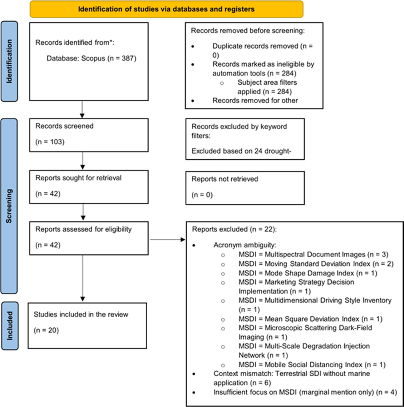
Figure 2.
The most used keywords in publications in the field of MSDI.
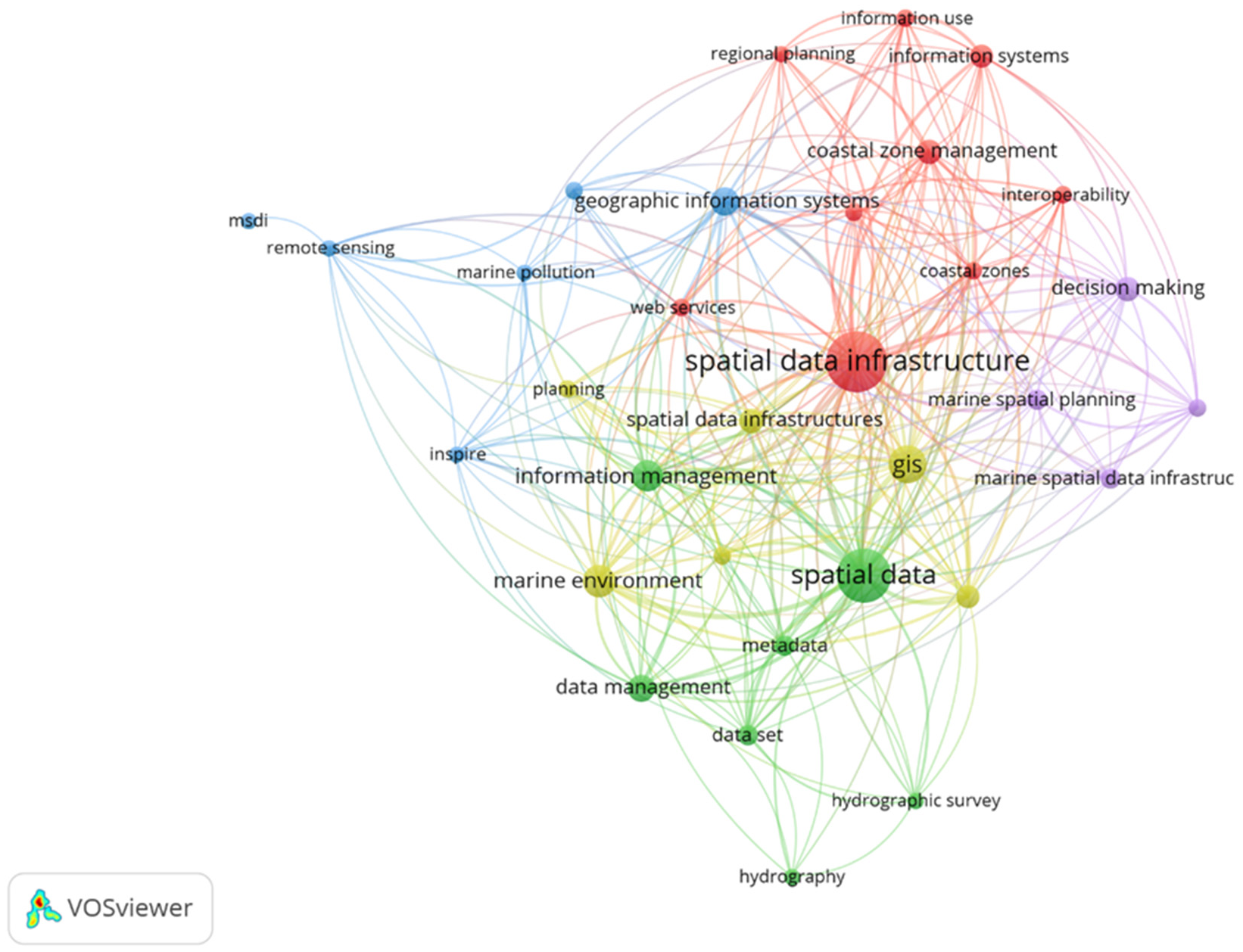
Figure 3.
Annual Scientific Production in MSDI Research (2002-2024).
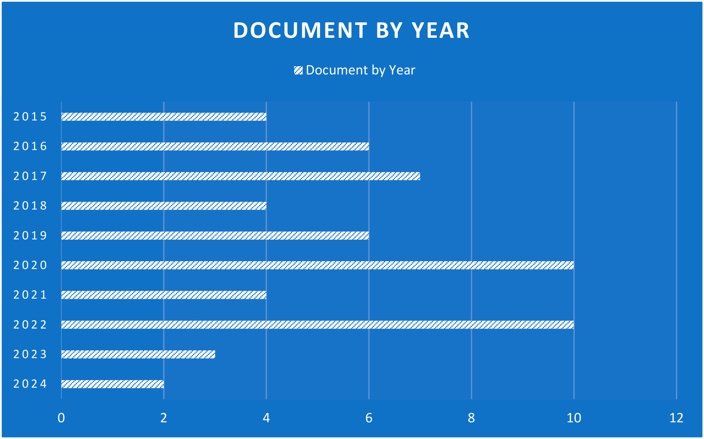
Figure 4.
Distribution of MSDI Publications by Country (First Author Affiliation).
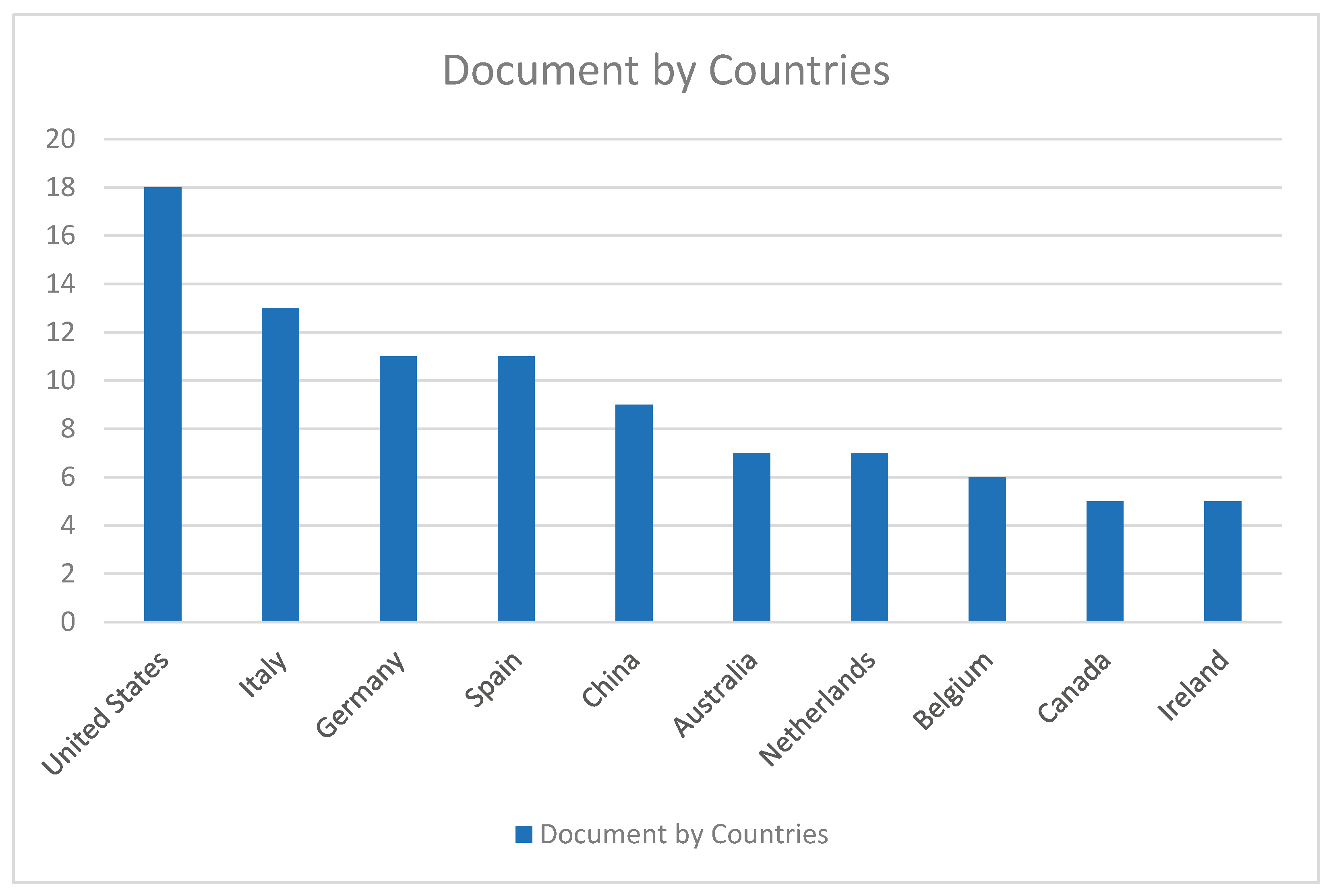
Figure 5.
Co-occurrence network analysis of author keywords.
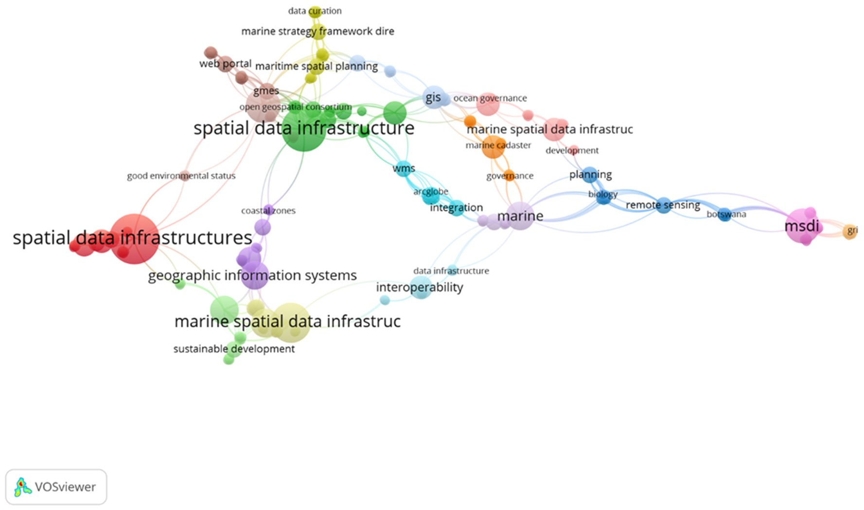
Table 1.
Inclusion and Exclusion Criteria.
| No. | Criterion Type | Specific Criteria | Description/Rationale |
| 1 | Inclusion Criteria | Content Relevance | Direct attention to the MSDI conceptualisation, application, assessment, or use as a marine/coastal environmental spatial data infrastructure. |
| 2 | Contextual Focus | Understandable marine, coastal, or oceanographic context of the spatial data infrastructure discussion. | |
| 3 | Document Type | Conference papers are listed in an index or in peer-reviewed journal articles. | |
| 4 | Temporal Scope | The date of publication lies between January 2000 and December 2024. | |
| 5 | Language | English-language publications | |
| 6 | Acronym Specificity | MSDI is specifically defined as Marine Spatial Data Infrastructure or marine spatial data infrastructures. | |
| 7 | Exclusion Criteria | Acronym Ambiguity | Articles which cite MSDI to name non-marine terms (e.g. Multivariate Standardised Drought Index, Multispectral Document Images). |
| 8 | Context Mismatch | Spatial Data Infrastructures on the earth or in fresh water without marine use or relevance. | |
| 9 | Publication Type | Technical reports, editorials, book reviews, theses or non-scholarly publications. | |
| 10 | Insufficient Focus | Shallow references to MSDI that do not contribute to the literature, analysis, and field. | |
| 11 | Methodological Papers | Articles that wholly deal with data processing algorithms and have no infrastructure or governance background. |
Table 2.
Top 10 Most Productive Authors in MSDI Research.
| No. | Author Name | SCID | TP | TC | H-Index | Most Cited MSDI-Related Article | Citations* | Affiliation (for MSDI work) | Country |
| 1 | Carrara, Paola | 7003807495 | 696 | 66 | 11 | RITMARE: Semantics-Aware harmonisation of data in Italian marine research | 22 | Consiglio Nazionale delle Ricerche (CNR) | Italy |
| 2 | Fugazza, Cristiano | 8905801200 | 340 | 44 | 9 | RITMARE: Semantics-Aware harmonisation of data in Italian marine research | 22 | Consiglio Nazionale delle Ricerche (CNR) | Italy |
| 3 | Hamre, Torill | 55961226400 | 140 | 27 | 6 | Design and implementation of a distributed GIS portal for oil spill and harmful algal bloom monitoring | 18 | Nansen Environmental and Remote Sensing Centre | Norway |
| 4 | Navas, Fatima | 6603801426 | 622 | 32 | 11 | Interoperability as a supporting tool for future forecasting in coastal and marine areas | 16 | Instituto Andaluz de Investigación | Spain |
| 5 | Oggioni, Alessandro | 6506971932 | 872 | 56 | 17 | RITMARE: Semantics-Aware harmonisation of data in Italian marine research | 22 | Consiglio Nazionale delle Ricerche (CNR) | Italy |
| 6 | Osborne, Mike | 55165790500 | 0 | 9 | 0 | The evolution and liberation of hydrographic data | 9 | OceanWise | UK |
| 7 | Pepe, Monica | 35757949900 | 1,696 | 82 | 22 | RITMARE: Semantics-Aware harmonisation of data in Italian marine research | 22 | Consiglio Nazionale delle Ricerche (CNR) | Italy |
| 8 | Tuama, Éamonn Ó. | 55445432200 | 633 | 18 | 9 | Design and implementation of a distributed GIS portal for oil spill and harmful algal bloom monitoring | 18 | GBIF Secretariat | Denmark |
| 9 | Abramic, Andrej | 55246038900 | 211 | 17 | 7 | A spatial data infrastructure for environmental noise data in Europe | 12 | Universidad de Las Palmas de Gran Canaria | Spain |
| 10 | Akinci, Halil | 26322246900 | 1,257 | 31 | 15 | The value of marine spatial data infrastructure for integrated coastal zone management | 15 | Artvin Coruh University | Turkey |
Note: TP = Total Publications (entire career); TC = Total Citations (entire career); Citations* = Number of citations received by the author's most cited MSDI-related article, current as of the search date (24 December 2024). SCID = Scopus Author ID.
Table 3.
Journal Distribution of MSDI Publications.
| No. | Journal | Number of Publications | Publisher | Impact Factor (2024) ** | Subject Category |
| 1 | Marine Policy | 3 | Elsevier | 4.3 | Marine Studies |
| 2 | Ocean & Coastal Management | 2 | Elsevier | 4.6 | Oceanography |
| 3 | ISPRS International Journal of Geo-Information | 2 | MDPI | 3.4 | Geography, Physical |
| 4 | Journal of Marine Science and Engineering | 2 | MDPI | 2.7 | Ocean Engineering |
| 5 | Data Science Journal | 1 | CODATA | 1.2 | Information Science |
| 6 | International Journal of Digital Earth | 1 | Taylor & Francis | 4.0 | Remote Sensing |
| 7 | Others (12 journals) | 9 | Various | Various | Various |
Note: Impact Factor data sourced from Journal Citation Reports (JCR) 2024, where available.
Table 4.
Quality Assessment Results of Included Studies.
| Quality Category | Score Range | Number of Studies | Percentage | Example Studies | Key Characteristics |
| High Quality | 10-12 | 11 | 55% | [4,10,18,28] | Clear objectives of research, strong methodology, clear data, valid conclusions, and high MSDI relevance. |
| Moderate Quality | 6-9 | 7 | 35% | [14,15,29,33] | Adequate methodology, certain limitations of transparency, generally supported conclusion, moderate MSDI focus. |
| Low Quality | 0-5 | 2 | 10% | [5,21] | Lack of clear objectives, methodology, lack of data transparency, and marginal MSDI relevance. |
Note: Quality appraisal by two researchers (κ = 0.85). The studies were evaluated on six dimensions, which included the clarity of objectives, methodological rigour, quality and transparency of data, analytical transparency, validity of findings, and relevance to MSDI.
Disclaimer/Publisher’s Note: The statements, opinions and data contained in all publications are solely those of the individual author(s) and contributor(s) and not of MDPI and/or the editor(s). MDPI and/or the editor(s) disclaim responsibility for any injury to people or property resulting from any ideas, methods, instructions or products referred to in the content. |
© 2026 by the authors. Licensee MDPI, Basel, Switzerland. This article is an open access article distributed under the terms and conditions of the Creative Commons Attribution (CC BY) license (http://creativecommons.org/licenses/by/4.0/).
Copyright: This open access article is published under a Creative Commons CC BY 4.0 license, which permit the free download, distribution, and reuse, provided that the author and preprint are cited in any reuse.


