Submitted:
06 February 2026
Posted:
09 February 2026
You are already at the latest version
Abstract
The increasing availability of high-resolution gridded meteorological data poses significant challenges for efficient storage and rapid data access. This study proposes an adaptive variable-resolution storage (AVRS) strategy for gridded meteorological datasets, in which the spatial resolution of data blocks is dynamically adjusted according to local feature characteristics. Composite radar reflectivity (CREF) data are employed as a representative case to evaluate the performance of the proposed method. The AVRS approach partitions the data into fixed-size spatial blocks and assigns multiple resolution levels based on block-level statistical properties, enabling high-resolution preservation in feature-intensive regions while applying coarser resolution in spatially homogeneous areas. Experimental results indicate that the proposed strategy achieves effective storage reduction, with compression ratios ranging from 11.60% to 14.44% of the original data volume. Despite the substantial reduction in storage size, high reconstruction accuracy is maintained. The MSE ranges from 0.74 to 1.54, with RMSE values between 0.86 and 1.24, while the MAE remains low (0.10–0.22). The PSNR consistently exceeds 34.90 dB, with an average value above 37 dB, demonstrating limited information loss and good structural preservation. In addition, the AVRS strategy significantly improves query efficiency, reducing the average query time from 0.5 s for fixed-resolution storage to 0.2 s. Overall, the proposed method provides a practical and efficient solution for managing large-scale gridded meteorological data in atmospheric research and operational applications.
Keywords:
gridded meteorological data
; weather radar data
; data compression
; adaptive variable-resolution storage
1. Introduction
High-resolution gridded meteorological data have become increasingly important for weather monitoring, nowcasting, and numerical weather prediction [1,2]. Among various observation systems, weather radar provides detailed and high-frequency measurements of atmospheric phenomena, producing large volumes of gridded data such as composite radar reflectivity products, which play a key role in severe weather monitoring and nowcasting [3,4,5]. Continuous improvements in spatial resolution, temporal frequency, and spatial coverage have significantly increased the volume of radar observations, posing substantial challenges for data storage, management, and efficient access[6].
In operational meteorological systems, radar mosaic products are commonly archived and distributed at a fixed spatial resolution [7]. Although high-resolution storage preserves fine-scale meteorological structures, it inevitably introduces considerable data redundancy, particularly in regions characterized by weak spatial variability or meteorologically inactive conditions. Conversely, coarse-resolution storage can effectively reduce data volume but may lead to the loss of critical information in dynamically active regions with strong spatial gradients, such as convective systems [8]. Achieving an appropriate balance between storage efficiency and data fidelity therefore remains a fundamental challenge for gridded meteorological data management.
Existing efforts to alleviate the storage burden of meteorological datasets have primarily focused on data compression techniques, including both lossless and lossy approaches [9]. Although compression methods can substantially reduce file sizes, they are typically applied uniformly across the spatial domain and do not explicitly consider the pronounced spatial heterogeneity of meteorological fields. As a result, compression-based approaches may still retain unnecessary redundancy in homogeneous regions or compromise important meteorological features in highly variable areas.
Recent studies have shown that intelligent reconstruction techniques, such as deep-learning-based recovery of composite radar reflectivity from satellite observations, can effectively preserve convective structures and intensity patterns under limited data conditions, highlighting the importance of feature-aware representations for radar fields[5]. Variable-resolution and multiscale representations offer an alternative perspective by allowing spatial resolution to adapt to data characteristics [10]. Such approaches have been explored in atmospheric modeling, data visualization, and numerical simulations. However, their application to the storage of operational gridded meteorological data—particularly weather radar products, remains relatively limited. Moreover, many existing variable-resolution methods rely on predefined spatial hierarchies or global refinement criteria, which may not adequately capture localized and application-specific variability in radar observations.
From an aviation perspective, meteorological information demand exhibits strong spatial selectivity. Aircraft operations are primarily constrained by predefined air routes and waypoints, and decision-making during flight is mainly influenced by weather conditions in the vicinity of these routes rather than across the entire meteorological domain. Consequently, uniformly storing radar data at the highest spatial resolution may be unnecessary for aviation-oriented applications, while insufficient resolution near air routes could adversely affect flight safety and operational efficiency.
Motivated by this observation, this study proposes an adaptive variable-resolution storage (AVRS) strategy for gridded weather radar data that explicitly incorporates air-route information. By partitioning the spatial domain into fixed-size blocks and assigning storage resolution based on both radar reflectivity characteristics and the density of air-route points, the proposed approach aims to preserve critical meteorological structures in aviation-relevant regions while significantly reducing data redundancy elsewhere. A composite radar reflectivity dataset is used as a case study to evaluate the effectiveness of the proposed strategy in terms of storage efficiency and data fidelity. The rest of this study is organized as follows. Section 2 describes the datasets used and details the methodologies employed. Section 3 presents the results and discusses the findings. Finally, conclusions are draw in Section 4.
2. Materials and Methods
2.1. Weather Radar Data
Composite radar reflectivity (CREF) is adopted in this study as the representative meteorological variable to characterize precipitation intensity and convective activity relevant to aviation operations. The CREF product is generated by mosaicking observations from multiple ground-based weather radars operated by the China Meteorological Administration (CMA), providing spatially continuous radar coverage over a broad regional domain.
The CREF data are provided on a regular latitude–longitude grid with a uniform horizontal resolution of 1 km, allowing direct representation as structured gridded data without additional spatial interpolation. The dataset covers a geographic domain extending from 12.2°N to 54.2°N in latitude and from 73°E to 135°E in longitude[11]. Each CREF mosaic is stored as a two-dimensional array of 4200 × 6200 grid points, resulting in substantial data volume when the native high resolution is retained across the entire domain.
An example of the composite radar reflectivity (CREF) mosaic over East Asia at 06:00 UTC on 1 July 2019, overlaid with representative aviation route waypoints, is shown in Figure 1. High reflectivity values are primarily associated with organized precipitation systems and embedded convective cells, whereas weak or near-zero reflectivity dominates large portions of the domain with little or no precipitation. Overall, the CREF field exhibits pronounced spatial heterogeneity, characterized by localized high-reflectivity regions embedded within extensive areas of relatively homogeneous or weak echoes.
From an aviation perspective, flight operations are strongly constrained to predefined air routes and waypoints, and weather-related hazards are therefore most sensitive to meteorological conditions in the vicinity of these route points rather than across the entire radar coverage area. In particular, regions with high air-route flight traffic, where a large number of flights repeatedly pass through the same waypoints, require detailed and high-resolution meteorological information. Intense precipitation and convective activity occurring near such route-adjacent regions can directly affect flight safety and operational decision-making, whereas large areas far from major air routes generally provide limited practical value for aviation applications, even if meteorological variability exists.
This inherent spatial mismatch between the uniformly high resolution of conventional radar products and the uneven distribution of aviation-relevant regions motivates the adoption of adaptive variable-resolution storage strategies. By jointly considering the intrinsic spatial variability of CREF fields and the spatial distribution and traffic intensity of aviation route waypoints, the dataset shown in Figure 1 provides an appropriate testbed for evaluating storage schemes that preserve fine-scale radar information in meteorologically active and aviation-critical regions while substantially reducing data volume in areas of lower operational relevance.
2.2. Adaptive Variable-Resolution Storage (AVRS)
To efficiently manage large volumes of gridded weather radar data while meeting aviation-oriented application requirements, an adaptive variable-resolution storage strategy is developed. The proposed method partitions the original high-resolution radar field into fixed-size blocks and assigns an appropriate storage resolution to each block by jointly considering radar reflectivity characteristics and air-route information. This design aims to preserve critical meteorological structures in aviation-relevant regions while reducing data redundancy in weak or homogeneous areas.
2.2.1. Block Partitioning and Feature Extraction
Let the original composite radar reflectivity field be denoted as
with a uniform spatial resolution of 1 km. The spatial domain is divided into non-overlapping square blocks of size L * L, denoted as
where Ωk represents the set of grid points belonging to the k-th block.
R(x, y), x = 1,…M, y= 1,…N,
Bk=[Ri, j], (i, j) ∈ Ωk,
For each block, the following radar-based statistical features are computed:
- Number of valid points
- 2.
- Fraction of valid points
which reflects the spatial coverage of radar echoes within the block.
- 3.
- Threshold exceedance count
2.2.2. Resolution Level Definition and Assignment Rules
In addition to radar-derived features, aviation operations impose strong spatial constraints, as aircraft primarily follow predefined air routes and waypoints. Regions intersected by major air routes are therefore of higher operational importance, even under relatively weak meteorological conditions. To incorporate aviation relevance into the adaptive storage strategy, air-route point flight traffic is introduced as an additional block-level feature.
Let denote the longitude and latitude of the p-th air-route point. The air-route flight traffic within block Bk is quantified as
where is the total number of air-route points. denotes the spatial extent of block Bk, and a larger value of indicates that more flights pass through the corresponding region, implying higher aviation operational importance.
Three discrete spatial resolution levels are defined: 1 km, 2 km, and 4 km, corresponding to high-, medium-, and low-resolution storage, respectively. Each block Bk is assigned a storage resolution based on a joint consideration of radar reflectivity characteristics and aviation relevance using threshold-based rules.
- 1.
- High-resolution (1 km)
- 2.
- Medium-resolution (2 km)
These blocks represent regions with moderate meteorological activity or limited aviation relevance, where an intermediate resolution provides a reasonable trade-off between data fidelity and storage efficiency.
- 3.
- Low-resolution (4 km)
All remaining blocks are assigned to low-resolution storage, including those with weak meteorological signals and no air-route traffic (). Such blocks are downsampled by a factor of 4 in both latitude and longitude directions.
After resolution assignment, each block is downsampled according to its resolution level before storage. This joint strategy ensures that fine-resolution data are preserved in meteorologically active or aviation-relevant regions, while coarser resolution is applied elsewhere to reduce storage requirements.
Figure 2.
Workflow of the proposed adaptive variable-resolution storage strategy. The original 1 km radar reflectivity field is partitioned into fixed-size blocks. For each block, radar reflectivity features and air-route point density are jointly evaluated to determine an appropriate storage resolution. Blocks are then downsampled accordingly and stored together with block-level resolution metadata.
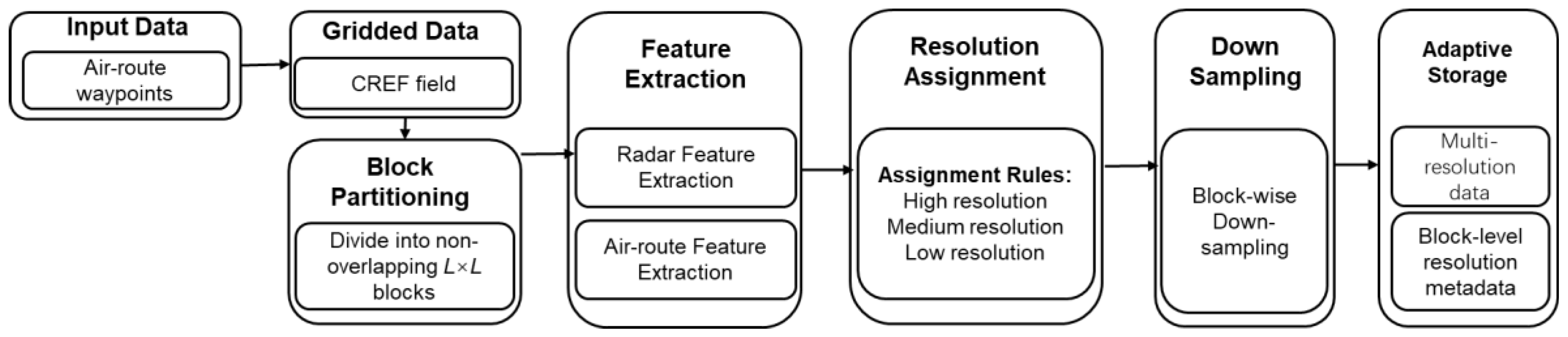
2.2.3. Computational Complexity and Storage Efficiency
Assuming the domain is partitioned into K blocks of size L×L, the extraction of radar-based features requires O(K⋅L2) operations as each grid point is processed once. The computation of air-route point counts involves O(P) operations, where P is the total number of air-route points.
Resolution assignment for each block involves simple threshold comparisons and incurs an additional O(k) computational cost. The storage overhead consists of downsampled radar data and lightweight block-level metadata indicating the assigned resolution. For a block with downsampling factor , the storage requirement is reduced by approximately sk2 relative to full-resolution storage. As high-resolution blocks typically occupy only a small fraction of the domain, substantial storage reduction can be achieved while preserving essential meteorological information for aviation applications. The block-based design also facilitates efficient data access and reconstruction at variable spatial resolutions.
2.3. Evaluation Metrics
The performance of the proposed adaptive variable-resolution storage strategy is evaluated using six complementary metrics: mean squared error (MSE), root mean squared error (RMSE), mean absolute error (MAE) [12], peak signal-to-noise ratio (PSNR) [13,14], space saving ratio (SSR)[14], and query time (QT)[15]. These metrics are designed to evaluate data fidelity, storage efficiency, and query performance from complementary perspectives.
- 1.
- Mean Squared Error (MSE)
- 2.
- Root Mean Squared Error (RMSE)
RMSE providing an interpretable error metric in the same units as reflectivity (dBZ).
- 3.
- Mean Absolute Error (MAE)
MAE measuring the average magnitude of reconstruction errors and less sensitive to extreme outliers.
- 4.
- Peak Signal-to-Noise Ratio (PSNR)
where is the maximum possible reflectivity. PSNR provides a normalized measure of reconstruction quality and is widely used for gridded data and image compression evaluation.
- 5.
- Space saving ratio (SSR)
SSR indicating the reduction in storage requirement achieved by the adaptive-resolution strategy. Higher SSR values correspond to more efficient storage utilization.
- 6.
- Query Time (QT)
QT is defined as the elapsed time between the initiation of a query request and the complete retrieval of the corresponding query results. where is the timestamp when the query is initiated, and is the timestamp when the query result is fully returned. This metric is adopted in database performance evaluation to characterize query execution latency, which is typically measured as the time difference between request issuance and result completion. A lower QT value indicates more efficient query performance compared with that of the original dataset.
3. Results and Discussion
The performance of the proposed route-aware adaptive variable-resolution storage scheme is evaluated from three complementary aspects: reconstruction accuracy, storage efficiency, and query performance. By jointly considering composite radar reflectivity intensity and the spatial distribution of aviation route waypoints, the proposed method aims to preserve high-resolution meteorological information in operationally critical regions while reducing data volume in route-irrelevant areas.
3.1. Reconstruction Accuracy
Table 1 summarizes the statistical characteristics of the reconstruction errors introduced by the adaptive route-aware variable-resolution storage strategy. Overall, the reconstruction errors remain at a relatively low level when compared with the original 1 km resolution CREF data. The mean MSE and RMSE are on the order of unity, while the MAE is approximately 0.16 dBZ, indicating that most grid-point differences are small in magnitude. The PSNR values range between 34.90 and 40.61 dB, with a median value of 38.34 dB, suggesting that the large-scale spatial patterns and dominant reflectivity features of the original radar fields are generally preserved after resolution adaptation. Similar PSNR levels have been reported in previous studies on lossy compression and resolution degradation of radar and NWP fields, where values above 35 dB were found to retain the main mesoscale and convective structures [16,17].
It is noted that higher reconstruction errors tend to occur in blocks stored at coarser resolution, which are mainly associated with weak-echo or meteorologically less active regions. This behavior is consistent with earlier findings that smoothing effects caused by spatial averaging or downscaling primarily affect low-reflectivity and stratiform precipitation areas, while intense convective cores are more robust to moderate resolution reduction [18].
Although some local smoothing effects are introduced in these regions, the overall impact on aviation-relevant reflectivity information is limited, as blocks adjacent to air-route waypoints are preferentially stored at higher spatial resolution. From an operational perspective, accurate depiction of high-reflectivity gradients and convective cells along flight routes is essential for hazard avoidance and tactical decision making. Therefore, prioritizing resolution in route-proximal regions ensures that key meteorological features critical to aviation safety are effectively preserved.
These results indicate that the proposed storage strategy can substantially reduce data volume while maintaining an acceptable level of reconstruction accuracy for route-focused aviation meteorological applications, in line with recent efforts toward scalable, application-aware management of high-resolution radar and atmospheric datasets [19,20].
Although some local smoothing effects are introduced in these regions, the overall impact on aviation-relevant reflectivity information is limited, as blocks adjacent to air-route waypoints are preferentially stored at higher spatial resolution. These results indicate that the proposed storage strategy can reduce data volume while maintaining an acceptable level of reconstruction accuracy for route-focused aviation meteorological applications.
3.2. Spatial Accuracy Along Flight Route Points
While the overall accuracy of the adaptive variable-resolution storage (AVRS) strategy has been quantitatively evaluated in Section 3.1 using global error metrics such as PSNR, RMSE, and MAE, these domain-averaged indicators cannot fully reflect the spatial distribution of reconstruction errors or their relevance to aviation operations. Accurate representation of strong convective reflectivity along flight routes is critical for flight safety, since deep convection and sharp reflectivity gradients are closely associated with turbulence, icing, and hazardous weather conditions [21].
Figure 3 shows the absolute error distributions of AVRS-reconstructed CREF for regions of strong (A), moderate (B), and weak (C) precipitation, with aviation route points overlaid. Across all regions, absolute errors remain below 10 dBZ, and no significant fluctuations are observed among different precipitation intensities. In Region A, intense convective cores are well preserved, with low errors concentrated outside the core areas. Similar robustness of convective structures under moderate resolution degradation has been reported in previous radar and NWP data compression studies, which showed that high-reflectivity cells and mesoscale organization can be retained when PSNR exceeds about 35 dB[16,17]. Region B shows similarly small errors along system edges, maintaining the overall spatial patterns along flight routes. In Region C, weak and scattered precipitation exhibits slightly more dispersed errors due to coarser resolution, but they remain within the 10 dBZ threshold, posing minimal operational impact. This behavior is consistent with earlier findings that resolution coarsening mainly affects low-reflectivity and stratiform regions, while having limited influence on the detection of high-impact convective features [18].
Overall, the AVRS strategy effectively preserves CREF accuracy near aviation routes regardless of precipitation intensity, maintaining key reflectivity structures in high-impact regions while reducing resolution in low-impact areas for storage efficiency. This demonstrates a robust balance between data volume reduction and meteorological reliability, supporting real-time aviation weather applications.
3.3. Storage Space Compression Performance
Figure 4 illustrates the relationship between storage space reduction ratio, reconstruction quality measured by PSNR, and single-point query time under different adaptive variable-resolution configurations. The results indicate that notable storage space savings can be achieved without a pronounced degradation in reconstruction accuracy or query efficiency. From the perspective of reconstruction quality, no clear monotonic relationship is observed between the storage space reduction ratio and the reconstruction error. As the compression ratio increases, the corresponding PSNR values remain relatively stable (Figure 4a), suggesting that higher compression does not necessarily lead to a significant increase in reconstruction error, which is consistent with previous findings that moderate lossy compression or resolution adaptation in atmospheric datasets can preserve key physical structures while substantially reducing data volume [21]. This behavior implies that the adaptive resolution assignment effectively preserves fine-resolution information in meteorologically and operationally important regions, while applying coarser representations primarily in areas with limited impact on overall data fidelity.
In terms of query performance, the single-point query time remains at a consistently low level across different compression settings, with most query times concentrated within a narrow range of approximately 0.2–0.3 s (Figure 4b). This indicates that the proposed storage scheme maintains a relatively high and stable query efficiency, even as the degree of data compression increases. The absence of substantial query-time degradation suggests that the reduction in data volume offsets the potential overhead introduced by variable-resolution indexing and block management.
Overall, these results demonstrate that the proposed adaptive variable-resolution storage strategy provides a balanced trade-off among storage efficiency, reconstruction accuracy, and query performance. Rather than exhibiting a strong compression–error or compression–query trade-off, the method achieves increased storage reduction while maintaining stable error characteristics and consistently efficient point-based query performance. This property is particularly advantageous for aviation-oriented applications, where both data accuracy and rapid access to localized meteorological information are essential.
3.4. Query Performance
Figure 5 compares the query time distributions of the original full-resolution dataset (Original) and the adaptive variable-resolution storage scheme (AVRS). For the original dataset, query times are mainly concentrated in the mid-to-high range, with a pronounced peak around 0.5–0.6 s. This indicates that querying uniformly high-resolution radar data generally incurs higher and more variable access latency, particularly when large data volumes need to be read and reconstructed, which is a common bottleneck in high-resolution radar archives and numerical weather data systems[20].
In contrast, the AVRS approach exhibits a markedly different query time distribution. Most queries are completed within a short time interval, with a dominant peak at approximately 0.2 s, and only a small fraction of queries extending beyond this range. This result demonstrates that the proposed variable-resolution storage significantly improves query efficiency by reducing the amount of data accessed during typical queries. Similar improvements in I/O performance through hierarchical or multiresolution data organization have been reported for radar and NWP datasets in cloud-native and compression-aware storage frameworks [17,22].
Since large portions of the domain are stored at coarser resolution, unnecessary data retrieval from meteorologically weak or aviation-irrelevant regions is effectively avoided. This application-aware data access strategy is consistent with previous studies emphasizing that prioritizing high-resolution storage and fast access in dynamically active or operationally critical regions can substantially enhance system responsiveness for real-time meteorological services [18].
Although a few AVRS queries show slightly longer response times, these cases are primarily associated with blocks stored at high resolution due to strong radar echoes or high aviation route traffic. Such behavior is expected and acceptable, as these regions require finer spatial detail to support aviation-relevant meteorological analysis. Importantly, even in these cases, the query times remain comparable to or lower than those of the original dataset.
Overall, the results indicate that the proposed AVRS method not only achieves substantial storage savings but also maintains high and stable query performance. The reduction in query time variability further suggests improved system responsiveness, making the approach well suited for large-scale gridded meteorological data management and aviation-oriented applications, in agreement with recent developments in scalable radar data archives and real-time weather information systems [20].
5. Conclusions
This study proposed an adaptive variable-resolution storage (AVRS) strategy for large-scale gridded meteorological datasets and evaluated its performance using composite radar reflectivity (CREF) as a representative variable. By dynamically assigning different spatial resolutions to fixed-size blocks according to local statistical characteristics, the method preserves fine-scale structures in regions with strong spatial variability while applying coarser representations in relatively homogeneous areas. This idea is consistent with previous efforts on weather radar data compression and scalable data management, which emphasize the need to balance storage efficiency and information preservation for high-resolution radar observations.
Quantitative experiments demonstrate that the AVRS framework can reduce the data volume to 11.60%–14.44% of the original full-resolution dataset, corresponding to a compression ratio of approximately 7–9. Despite this substantial reduction, high reconstruction fidelity is maintained, with PSNR values consistently exceeding 34.9 dB and an average above 37 dB, as well as low RMSE (0.86–1.24) and MAE (0.10–0.22). These results indicate that the essential spatial patterns and intensity structures of CREF are well preserved, in line with recent findings that moderate lossy compression of meteorological fields can retain key physical features while substantially reducing data volume.
In addition to storage efficiency, the AVRS strategy improves data access performance by reducing the average query time from about 0.5 s to approximately 0.2 s. Such gains are particularly relevant in the context of rapidly growing radar archives and emerging cloud- and edge-based processing frameworks, which require both compact storage and fast data retrieval for real-time or near-real-time applications.
Overall, the proposed AVRS framework provides an effective and scalable solution for managing high-resolution radar and other gridded meteorological datasets. By adaptively allocating spatial resolution according to local data characteristics, it achieves a robust balance between storage compression, reconstruction accuracy, and query efficiency, thereby supporting both atmospheric research and operational applications. Future work will extend this approach to additional meteorological variables and multi-source datasets, and further explore its integration into real-time processing systems and cloud-native data infrastructures, which are increasingly important for next-generation weather analysis and aviation meteorological services.
Author Contributions
Conceptualization, J.L. and Q.H.; methodology, J.L.; software, Q.H. and X.H.; validation, J.L., X.H. and Q.H.; formal analysis, J.L.; investigation, J.L.; resources, X.C.; data curation, X.C.; writing—original draft preparation, J.L., X.H. and Q.H.; writing—review and editing, J.L.; visualization, J.L.; supervision, J.L.; project administration, X.C. and Y.H.; funding acquisition, Y.T. All authors have read and agreed to the published version of the manuscript.
Funding
This research was funded by State key Laboratory of Air Traffic Management System and Technology (Nos. SKLATM202205) and Aeronautical Science Foundation of China (Nos. 20220027052001).
Institutional Review Board Statement
Not applicable.
Informed Consent Statement
Not applicable.
Data Availability Statement
The processed data that support the findings of this study are available from the corresponding author upon reasonable request.
Acknowledgments
During the preparation of this manuscript, the authors used ChatGPT for the purposes of language editing and improving the clarity and readability of the manuscript. The authors have reviewed and edited the output and take full responsibility for the content of this publication.
Conflicts of Interest
The authors declare no conflicts of interest.
References
- Kalnay, E. Atmospheric modeling, data assimilation and predictability; Cambridge university press, 2003. [Google Scholar]
- Bauer, P.; Thorpe, A.; Brunet, G. The quiet revolution of numerical weather prediction. Nature 2015, 525, 47–55. [Google Scholar] [CrossRef] [PubMed]
- Doviak, R.; Zrnic, D. Doppler radar and Weather Observations; Academic Press: Orlando, FL, 1993; Volume 468. [Google Scholar]
- Binetti, M.S.; Campanale, C.; Massarelli, C.; Uricchio, V.F. The use of weather radar data: Possibilities, challenges and advanced applications. Earth 2022, 3, 157–171. [Google Scholar] [CrossRef]
- Zhao, J.; Tan, J.; Chen, S.; Huang, Q.; Gao, L.; Li, Y.; Wei, C. Intelligent reconstruction of radar composite reflectivity based on satellite observations and deep learning. Remote Sensing 2024, 16, 275. [Google Scholar] [CrossRef]
- Stolorz, P.E.; Nakamura, H.; Mesrobian, E.; Muntz, R.R.; Shek, E.C.; Santos, J.R.; Yi, J.; Ng, K.W.; Chien, S.; Mechoso, C.R. Fast Spatio-Temporal Data Mining of Large Geophysical Datasets. In Proceedings of the KDD, 1995; pp. 300–305. [Google Scholar]
- Zhang, J.; Howard, K.; Langston, C.; Kaney, B.; Qi, Y.; Tang, L.; Grams, H.; Wang, Y.; Cocks, S.; Martinaitis, S. Multi-Radar Multi-Sensor (MRMS) quantitative precipitation estimation: Initial operating capabilities. Bulletin of the American Meteorological Society 2016, 97, 621–638. [Google Scholar] [CrossRef]
- Fabry, F. Radar meteorology: principles and practice; Cambridge University Press, 2015. [Google Scholar]
- Di, S.; Liu, J.; Zhao, K.; Liang, X.; Underwood, R.; Zhang, Z.; Shah, M.; Huang, Y.; Huang, J.; Yu, X. A survey on error-bounded lossy compression for scientific datasets. ACM computing surveys 2025, 57, 1–38. [Google Scholar] [CrossRef]
- Ringler, T.; Ju, L.; Gunzburger, M. A multiresolution method for climate system modeling: Application of spherical centroidal Voronoi tessellations. Ocean Dynamics 2008, 58, 475–498. [Google Scholar] [CrossRef]
- Min, C.; Chen, S.; Gourley, J.J.; Chen, H.; Zhang, A.; Huang, Y.; Huang, C. Coverage of China new generation weather radar network. Advances in Meteorology 2019, 2019, 5789358. [Google Scholar] [CrossRef]
- Lakshmanan, V.; Karstens, C.; Krause, J.; Tang, L. Quality control of weather radar data using polarimetric variables. Journal of Atmospheric and Oceanic Technology 2014, 31, 1234–1249. [Google Scholar] [CrossRef]
- Huynh-Thu, Q.; Ghanbari, M. Scope of validity of PSNR in image/video quality assessment. Electronics letters 2008, 44, 800–801. [Google Scholar] [CrossRef]
- Li, Z.; Ramos, A.; Li, Z.; Osborn, M.L.; Li, X.; Li, Y.; Yao, S.; Xu, J. An optimized JPEG-XT-based algorithm for the lossy and lossless compression of 16-bit depth medical image. Biomedical Signal Processing and Control 2021, 64, 102306. [Google Scholar] [CrossRef]
- Currim, S.; Snodgrass, R.T.; Suh, Y.-K.; Zhang, R. DBMS metrology: measuring query time. ACM Transactions on Database Systems (TODS) 2016, 42, 1–42. [Google Scholar] [CrossRef]
- Zeng, Q.; He, J.; Shi, Z.; Li, X. Weather Radar Data Compression Based on Spatial and Temporal Prediction. Atmosphere 2018, 9, 96. [Google Scholar] [CrossRef]
- Tintó Prims, O.; Redl, R.; Rautenhaus, M.; Selz, T.; Matsunobu, T.; Modali, K.R.; Craig, G. The effect of lossy compression of numerical weather prediction data on data analysis: a case study using enstools-compression 2023.11. Geoscientific Model Development 2024, 17, 8909–8925. [Google Scholar] [CrossRef]
- Saltikoff, E.; Friedrich, K.; Soderholm, J.; Lengfeld, K.; Nelson, B.; Becker, A.; Hollmann, R.; Urban, B.; Heistermann, M.; Tassone, C. An overview of using weather radar for climatological studies: Successes, challenges, and potential. Bulletin of the American Meteorological Society 2019, 100, 1739–1752. [Google Scholar] [CrossRef]
- Hu, Z.; Xu, X.; Zhang, Y.; Tang, H.; Cheng, Y.; Qian, C.; Khosravi, M.R. Cloud–edge cooperation for meteorological radar big data: a review of data quality control. Complex & Intelligent Systems 2022, 8, 3789–3803. [Google Scholar] [CrossRef]
- Ladino-Rincon, A.; Nesbitt, S.W. Radar DataTree: A FAIR and Cloud-Native Framework for Scalable Weather Radar Archives. arXiv arXiv:2510.24943.
- Sharman, R.; Trier, S.; Lane, T.; Doyle, J. Sources and dynamics of turbulence in the upper troposphere and lower stratosphere: A review. Geophysical Research Letters 2012, 39. [Google Scholar] [CrossRef]
- Dueben, P.D.; Bauer, P. Challenges and design choices for global weather and climate models based on machine learning. Geoscientific Model Development 2018, 11, 3999–4009. [Google Scholar] [CrossRef]
Figure 1.
Example mosaics of composite radar reflectivity (CREF) at 06:00 UTC on 5 July 2019 used in this study:(a) original CREF at 1 km spatial resolution; (b) CREF overlaid with aviation route points for variable-resolution storage.
Figure 1.
Example mosaics of composite radar reflectivity (CREF) at 06:00 UTC on 5 July 2019 used in this study:(a) original CREF at 1 km spatial resolution; (b) CREF overlaid with aviation route points for variable-resolution storage.
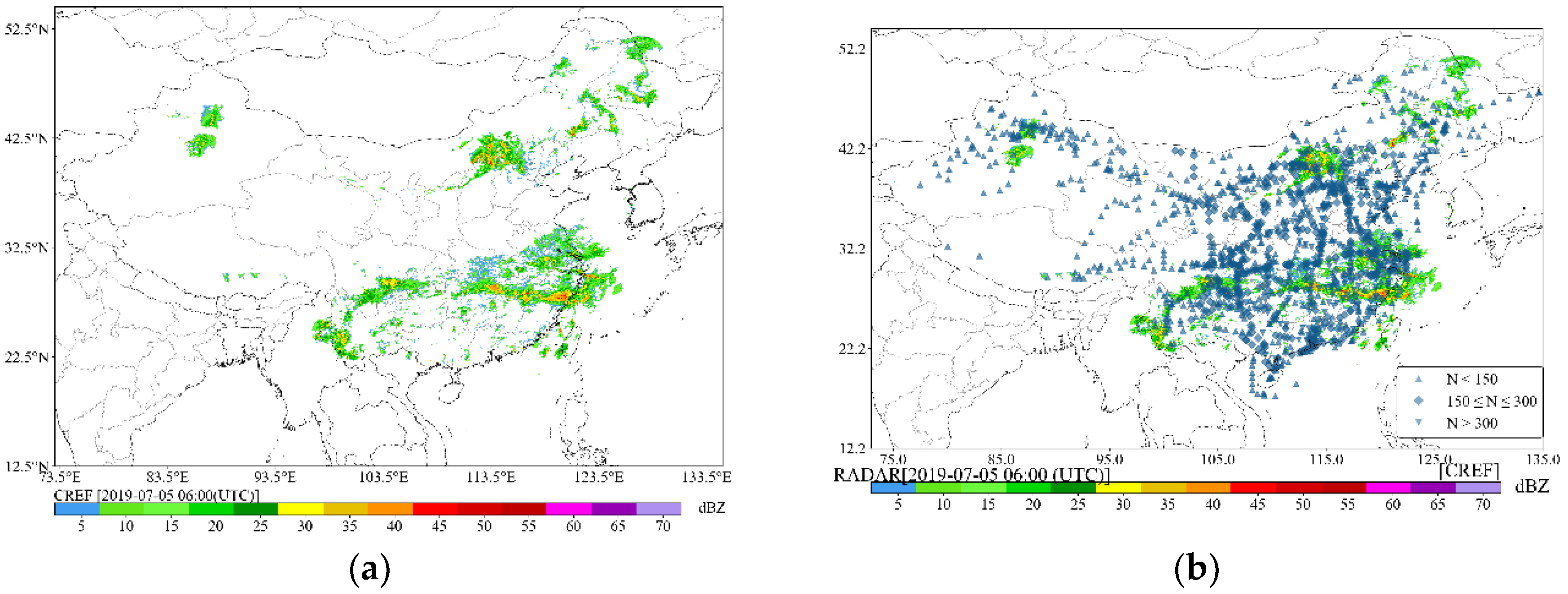
Figure 3.
Comparison between the original-resolution and AVRS composite radar reflectivity (CREF) data and the corresponding error distributions for the case at 18:00 UTC on 15 July 2019: (a) CREF at the original spatial resolution; (b) CREF stored using the variable-resolution strategy; (c) overall error distribution between the two datasets; (d) error distribution in Region A with intense precipitation; (e) error distribution in Region B with moderate precipitation; (f) error distribution in Region C with weak precipitation.
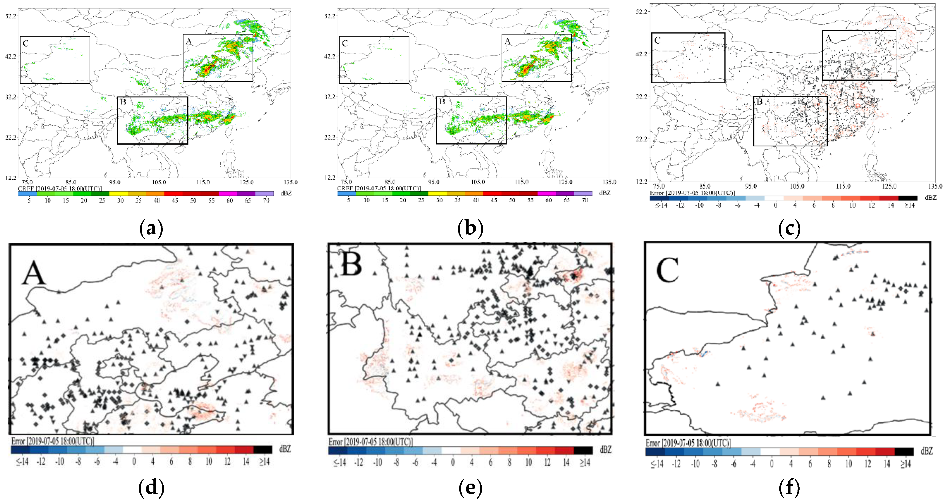
Figure 4.
Relationship between storage space reduction ratio, (a) reconstruction quality (PSNR), and (b) single-point query time for AVRS.
Figure 4.
Relationship between storage space reduction ratio, (a) reconstruction quality (PSNR), and (b) single-point query time for AVRS.
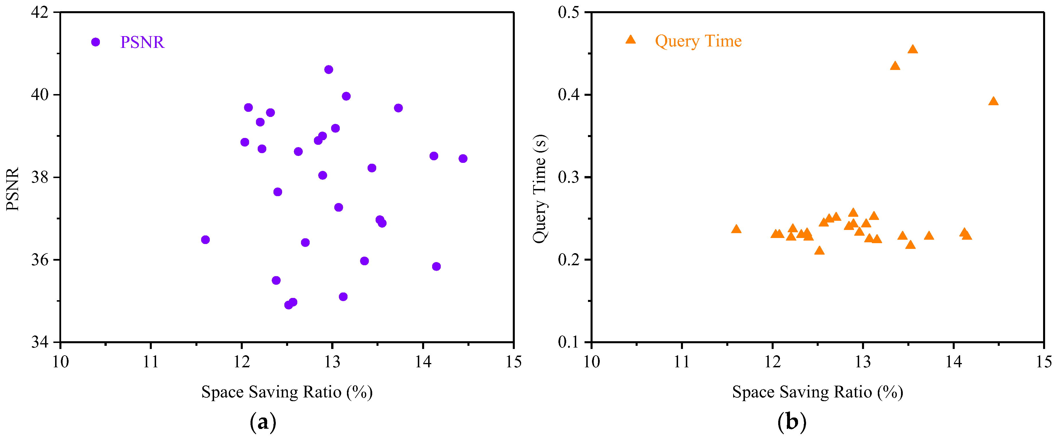
Figure 5.
Query time distribution comparison between the original full-resolution dataset and the adaptive variable-resolution storage (AVRS) scheme.
Figure 5.
Query time distribution comparison between the original full-resolution dataset and the adaptive variable-resolution storage (AVRS) scheme.
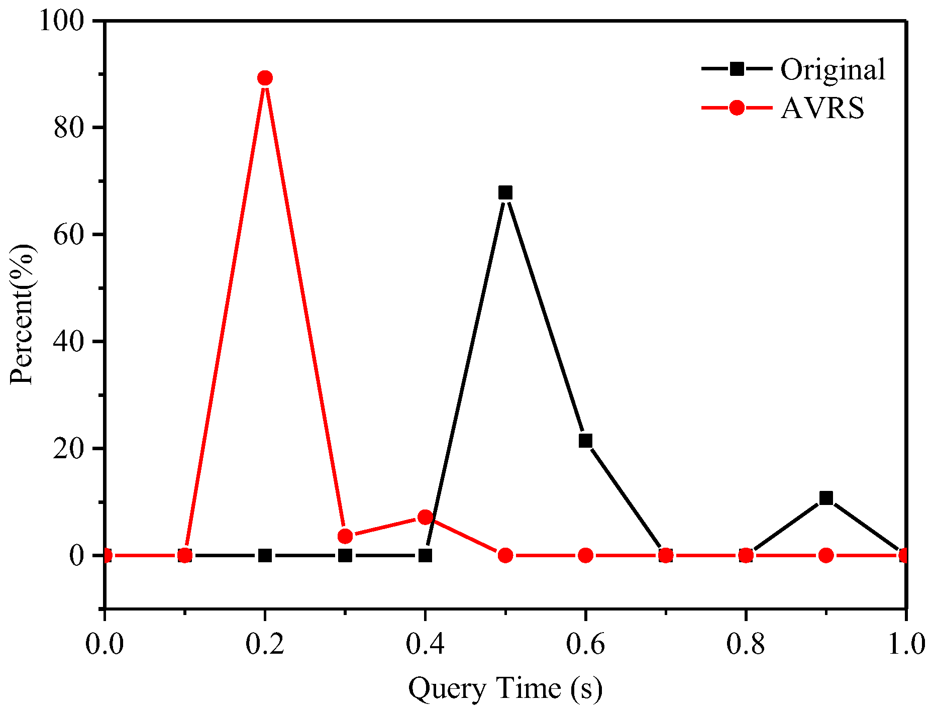

Table 1.
Statistical summary of reconstruction accuracy metrics for the adaptive route-aware variable-resolution CREF storage.
Table 1.
Statistical summary of reconstruction accuracy metrics for the adaptive route-aware variable-resolution CREF storage.
| Metrics | Min. | Average | Median | Max. |
|---|---|---|---|---|
| MSE | 0.74 | 1.15 | 1.16 | 1.54 |
| RMSE | 0.86 | 1.07 | 1.08 | 1.24 |
| MAE | 0.10 | 0.16 | 0.16 | 0.22 |
| PSNR | 34.90 | 37.83 | 38.34 | 40.61 |
Disclaimer/Publisher’s Note: The statements, opinions and data contained in all publications are solely those of the individual author(s) and contributor(s) and not of MDPI and/or the editor(s). MDPI and/or the editor(s) disclaim responsibility for any injury to people or property resulting from any ideas, methods, instructions or products referred to in the content. |
© 2026 by the authors. Licensee MDPI, Basel, Switzerland. This article is an open access article distributed under the terms and conditions of the Creative Commons Attribution (CC BY) license (http://creativecommons.org/licenses/by/4.0/).
Copyright: This open access article is published under a Creative Commons CC BY 4.0 license, which permit the free download, distribution, and reuse, provided that the author and preprint are cited in any reuse.


