
Submitted:
29 January 2026
Posted:
30 January 2026
You are already at the latest version
Abstract
This article develops a typology of U.S. depopulating cities beyond the Rust Belt's iconic industrial cities, which dominate academic literature, to include a wider range of shrinking settlements in the shadows. Using population change from 1990–2020 and three explanatory dimensions—city size, industrial heritage, and peripheral location—the analysis identified 1,082 places that lost at least 10% of their population. Logistic regression showed manufacturing and mining reliance, small size, and remoteness as significant predictors of depopulation. Based on these factors, settlements are divided into seven types, from large urban centers to small peripheral towns with fewer than 5,000 people. The overwhelming predominance of small towns (97%) in the sample highlights their distinct development challenges and questions the narrative of decline focused solely on larger industrial cities. By situating American trajectories within the broader shrinking cities discourse, the findings demonstrate the value of typology as a methodological tool for identifying intra-group heterogeneity, capturing regional differences, and establishing a more reliable basis for comparative urban studies. Ultimately, the study shows that urban decline in the United States is not exclusively a Rust Belt phenomenon, but a multidimensional process encompassing different scales, sectors, and geographies.
Keywords:
post-industrial transition
; population change
; small urban areas
; Rust Belt
; USA
1. Introduction
1.1. The Shrinking Cities Discourse
Scholars widely consider the late 1960s the beginning of a deep urban crisis in the United States and beyond. Mounting racial unrest, fiscal instability, deindustrialization, and suburbanization destabilized the foundations of the postwar urban environment [1,2]. Researchers and policymakers sought new frameworks to narrate the decline of the Fordist city with widening socio-spatial inequalities. As Harvey [3] argued, the city could no longer be viewed merely as a neutral container for growth, but rather as a terrain of political and economic struggle.
It was precisely in this context of disorientation and systemic change that Lefebvre’s findings [4] offered a radical intellectual intervention. Lefebvre introduced the concept of explosion and dismantled the rigid binary of urban and rural, a dichotomy that was not previously called into sufficient question in the analysis of urbanization processes. Explosion describes a situation in which the development of urban capitalism no longer depends on industrialization and intensifies the agglomeration of economic activity to such an extent that entire regions and countries find themselves de facto on the periphery of large urban areas [4,5].
This view of urban development trends served as the basis for Brenner and Schmid’s [6] framework of planetary urbanization, in which they point to the global nature of the trends identified by Lefebvre. In this context, urbanization is understood as a multidimensional spatio-temporal process with internal multi-relativities, encompassing the global landscape. Planetary urbanization leads to the maximization of two processes: growing inequality and the tight-knit interconnectedness between cities of different sizes and a plethora of intermediate forms of what Saskia Sassen refers to as “cityness” [6,7,8,9,10,11,12].
The uneven development and interconnectedness of urban areas in the context of planetary urbanization means that while some cities are growing and thriving, others are shrinking and declining. However, the processes of urban decline do not “mirror” the processes of urban growth, being: 1) uneven among different demographic groups, 2) nonlinear in their dynamics, 3) correlated with depopulation differently than urban growth is correlated with population growth, 4) less controllable than growth processes, 5) decentralized and informal, in contrast to centralized and more formalized growth, 6) causing a conservative reaction among actors planning their future in connection with a degrading city (e.g., among investors) [13].
The mainstream approach to conceptualizing negative trends associated with population decline is to use the urban shrinkage framework. Due to the prevalence of urban decline across regions of the world, the challenges of responding to it, and the threats it poses to the well-being of city dwellers, the body of literature on urban shrinkage has been steadily growing, especially since the 2000s [14,15,16,17]. The discourse on shrinking cities quickly spread beyond Germany and other European nations [18,19], enriched by numerous studies of cities in North America [20,21,22,23,24,25], China [26,27,28], Russia [29,30,31,32], as well as large samples of cities around the world [33].
Despite the evident relevance of research on shrinking cities, this concept is often criticized due to the lack of a consensus definition and the associated difficulties in analysis. Even researchers who use this term often note its shortcomings. Among the most notable critical views is an article by Matthias Bernt, in which he uses a vivid burger metaphor: “…the metaphor which comes to mind is a ‘burger’ ... What defines the shrinking cities burger is population loss as the meat, whereas the two accompanying bits of the bun (causes and impacts) are of minor significance, yet still essential for qualifying the whole meal as a burger. As for the bun, there is some flexibility among gourmets whether wholewheat is preferable to, say, rye, and some would even use a baguette or other sort of bread, and this is also true for the shrinking cities debate which seems to be quite flexible with regard to different causes and impacts, as long as the main component (i.e. population loss) is still in the centre. Political issues such as ‘governance’ then take on the role of French fries–not a necessary component, but helpful in making the meal more substantial” [34; p. 444]. This metaphor is derived from three key aspects: 1) all definitions of shrinking cities focus on population decline, which is easy to quantify, but the thresholds for what constitutes shrinking vary greatly; 2) indicators characterizing the external environment or economic conditions (e.g., macroeconomic trends) are often used as explanatory factors; 3) the typical problems often faced by shrinking cities are often considered to be country-specific, which does not allow for a universal definition [34]. As one of the proposals for strengthening the methodological potential of the shrinking city concept, Bernt suggests focusing on the center-periphery dynamics of power relations, using the idea of peripherization [34,35]. In this context, the city is viewed not as an essence but as a product of asymmetrical relations between the center, with capitalist and political agency, and the periphery, which is subordinated to the center’s decisions.
Although the shrinking cities framework has become the dominant way of theorizing negative urban trajectories, its ambiguity presents both a strength and a weakness. The global debate it generated provides a fertile intellectual landscape, offering conceptual insights into uneven development, governance, and socio-spatial restructuring [18,36,37]. At the same time, as critics note, “urban shrinkage” tends to function as an umbrella term rather than a precise analytical tool, often conflating demographic, economic, and social processes without establishing clear thresholds [34,38].
For the purposes of this paper, we deliberately anchor the review in the shrinkage literature because it remains the most developed and influential body of scholarship on urban decline worldwide. Yet, in empirical analysis, we use the more precise term “urban depopulation”. Unlike “shrinkage,” which foregrounds multi-dimensional processes but risks conceptual vagueness, “depopulation” provides a measurable basis for comparative case analysis. This distinction is especially critical for the U.S. context, where cities and regions face profoundly heterogeneous trajectories of loss depending on size, industrial legacy, and location [21,23,39].
Thus, the goal of this paper is to enrich analytical clarity with conceptual depth: by situating depopulation within the broader shrinkage debate, we aim to develop a typology of depopulating places in the United States, one that moves beyond crisis narratives and instead accounts for the differentiated geographies of population loss. In doing so, the paper contributes both to the literature on shrinking cities and provides a more methodologically robust entry point for comparative urban studies.
1.2. Urban Depopulation in the U.S. Context
In contrast to the European discourse, where population decline was explicitly framed as a distinct urban condition requiring new policies and planning paradigms [14,18], the literature on America’s shrinking cities focused more on multidimensional critique of the status quo in urban areas. Here, depopulation has often been embedded in broader discussions of suburbanization, post-industrial restructuring, and regional inequality [40,41,42]. Together, these strands of research position the U.S. as a critical site for examining urban shrinkage: a country with some of the most dramatic cases of depopulation worldwide, and with the tradition of comprehensive research of the problem.
Post-industrial cities in the United States have provided some of the richest empirical material for understanding the dynamics of urban shrinkage. Classic instances of population loss, such as Flint, Detroit, Cleveland, and St. Louis, have been used as archetypes for global debates about industrial decline, fiscal stress, and racialized patterns of disinvestment [2,43,44]. More recent studies, however, have moved beyond these iconic examples to emphasize the diversity of shrinking cities across metropolitan area cores, medium-sized industrial towns, and peripheral communities [20,21,24]. The geographies of shrinking cities are not limited to the industrial centers of the Rust Belt that have failed to adapt to the shifts in the service economy and the small towns of the American South that suffer from chronic poverty. Shrinkage is also evident in California and along the middle Mississippi River, as well as in multitude of rural communities across the country [23].
In the 2010s, a new term—legacy cities—emerged for those American cities experiencing shrinkage, which in the mid-20th century were important industrial centers until the number of jobs and the volume of economic production led to a deep economic crisis during the post-industrialization period [45,46,47,48]. The use of this term for a specific type of city allows the academic community to develop practical proposals to support such places [49], especially in the physical dimension, taking into account several decades of experience with gentrification, revitalization of abandoned industrial zones, or, in other cases, desertification and total degradation of infrastructure [50,51]. Often, in situations where shrinkage is not the focus of research, legacy cities are also referred to as older industrial cities [45,52].
Studies of shrinking cities in the United States highlight the multifaceted nature of depopulation and socio-economic decline. Franklin [53] demonstrated that between 1980 and 2010, population decline was particularly pronounced in cities in the Rust Belt of the Midwest and Northeast. Medium-sized and small cities were the most vulnerable: they lost population faster than larger centers and had fewer opportunities to adapt. There are also differences between demographic groups: shrinking cities more often saw a loss of population among young people and the working-age population, while the proportion of older people grew. This highlights the global trend of population aging and shrinkage [54], where the demographic structure exacerbates the effects of economic decline.
Danko and Hanink [55] showed that between 1990 and 2010, shrinking cities in the U.S. not only lost population but also faced growing social inequality: poverty and racial segregation increased, while employment opportunities declined. The authors emphasize that the geography of shrinking cities is uneven: they are most concentrated in old industrial regions, while the South and the West show more examples of growing cities.
Ribant and Chen [23] made a significant contribution to understanding the geographical distribution of depopulation in U.S. cities by proposing a detailed methodology for identifying shrinking cities and their spatial typology. The authors used data from population censuses (1790–2010) and the American Community Survey (2011–2015) to form a database of 1,600 cities that had ever reached a population threshold of 25,000. The criterion for shrinking included not only demographic decline, but also economic indicators such as poverty and employment rates. The final list comprised 367 shrinking cities. The authors then used GIS mapping and MSA/MiSA classification to identify groups of central, nearby, and peripheral shrinking cities. This step allowed them to identify spatial patterns: for example, the concentration of small shrinking towns around large core cities.
In the next stage, they applied cluster analysis (the K-means method) to large central shrinking cities. The model included four key indicators: poverty level, its dynamics from 1980 to 2010, changes in employment in basic sectors (agriculture, mining, industry), and the share of foreign-born population. The latter variable was considered a possible factor of demographic stabilization. The final analysis revealed the heterogeneity of shrinking cities: some groups are characterized by deep industrial decline and rising poverty, while others are undergoing milder forms of transformation, mitigated by immigration and diversification.
Thus, typology is not merely a classification tool, but an important method for identifying intra-group differences, recording regional patterns, and highlighting cities that are most vulnerable to structural degradation. In the case of the United States, this approach is particularly valuable because depopulation processes are highly geographical in nature, and typology allows us to link population dynamics to the characteristics of the economic base, social characteristics, and the role of the city in the settlement system.
2. Materials and Methods
The novelty of this paper lies in the construction of a methodology for the research of depopulation trends in different cities of the United States using newer data and the typology method. It is based on an assessment of the cities’ economic structure, position in the urban hierarchy, and spatial distance from principal cities (cores) of the CBSA. The analytical framework focuses on structural and territorial factors contributing to demographic decline and uses publicly available spatial, demographic, and economic data at the census place level as defined by the U.S. Census Bureau.
Population data for 1990 and 2020 were collected from The National Historical Geographic Information System (NHGIS) and further cross-checked with aggregated data from The U.S. Census Bureau to ensure consistency over time and space. Population decline was defined as a binary variable taking a value of 1 if the population of a city decreased by 10% or more between 1990 and 2020, and 0 otherwise. The total sample of shrinking cities consisted of 1,082 places.
As we noted earlier, referring to Bernt [34], one of the main problems with research on depopulating cities in the context of the urban contraction concept is the lack of clear criteria for setting cut-off points. Among the many options, we chose the most inclusive one (10% over 30 years) because choosing a higher cutoff point or a shorter period would narrow our sample almost exclusively to small cities, where population losses of more than 20% are more common than in large cities. We sought to expand the sample size to search for patterns among a greater variety of depopulation trajectories. The choice of 1990 as the starting point for the analysis is related to the fact that: 1) during this period, American cities entered the final phase of the formation of the post-Fordist economic order [56,57], 2) the beginning of the 1990s marked a “comeback” for American cities after decades of decline [1,58], and 3) it was the year of the U.S. census.
To assess the economic structure, data on employment by industry at the settlement level were used, collected from County Business Patterns (CBP). For each settlement, the share of people employed in manufacturing and mining was calculated (E4P002: Mining; E4P004: Manufacturing, nondurable goods; E4P005: Manufacturing, durable goods) based on 1990 data. In the absence of data at the settlement level, the values for the corresponding county were used, adjusted for the city’s share of the county’s population. Places that fell into Q1 (top 25%) in terms of the total share of people employed in these industries were classified as industrial legacy cities. In our sample, the calculated threshold value is 27%.
To determine the hierarchical position of a city, each census place was assigned a size class based on its population in 1990:
- Large cities: more than 100,000 inhabitants.
- Medium-sized cities: 25,000 to 100,000.
- Small towns: less than 25,000.
This classification is widely used in the literature on urbanization and allows us to assess the prevalence of decline among different levels of the urban hierarchy. In particular, this division (with an additional group of 5,000 to 25,000 people) is utilized by González-Val, who investigated the relationship between the population of American cities, size groups, their geographical location, and founding years of the city [59,60,61,62].
To assess the spatial remoteness of settlements, a user database was compiled of the locations of principal cities using the U.S. Census Bureau classification and geocoding. All the data were georeferenced to the 2020 Census place geometry based on TIGER/Line files. Distances from the centers of all settlements to the nearest major cities were calculated using the Haversine Formula method, which was used to identify core and peripheral cities. Peripheral cities were those that fell into Q1 (top 25%) in terms of remoteness (when sorted from greater to lesser distance). In our sample, the threshold value resulting from these calculations is 75 km (46.6 mi).
The typology was constructed after assessing the statistical significance of each indicator based on logistic regression, in which the dependent variable was population decline, and the independent variables were three indicators:
- The share of people employed in manufacturing and mining.
- The size class of the city as an indicator of its position in the settlement hierarchy.
- Distance to the principal city of CBSA as an indicator of the central or peripheral location of the city without reference to administrative boundaries and with the possibility of accounting for inter-state connections.
The model was implemented using the statsmodels library in Python 3.11. The variables were standardized, and multicollinearity was checked using VIF (all values <3). The model showed that dependence on industry, small size, and remoteness from principal cities are associated in a statistically significant way with a higher probability of downsizing (p <0.001). For example, an increase in the share of people employed in industry by 1 standard deviation increased the probability of downsizing by approximately 42% (OR ≈ 1.42); a similar increase in distance from the principal city gave OR ≈ 1.31.
All calculations and data processing operations were executed within the Anaconda distribution (2024 version), using a dedicated Python 3.11 virtual environment with the following libraries:
- geopandas and shapely for working with geodata.
- pandas for tabular calculations.
- numpy for vector operations.
- statsmodels for regression analysis.
- scikit-learn for normalization and clustering.
- pysal for spatial statistics.
Parts of the methodological design and typology construction were supported through iterative collaboration with OpenAI’s ChatGPT (version GPT-4, via ChatGPT Plus, accessed August 2025). The tool was used to assist in code structuring, debugging, and statistical interpretation. Final decisions on all data processing, modeling, and interpretation were made by the authors, as well as writing and editing of the text.
3. Results and Discussion
3.1. The Typology
A total of 1,082 census places that lost 10% or more of their population between 1990 and 2020 were divided into 7 types (see Table 1). The types were not predetermined; they were identified through calculations. We refer to types without industrial specialization as diverse, without delving into the structure of employment in agriculture and services, because previous work on shrinking cities has shown that it is precisely the presence of industry, with its rigid framework of social practices and economic structure, that is fundamental. That is, a particular service sector may prevail in a city, but in this case, the main type of economic actors will be businesses—predominantly small ones—which have much greater opportunities to change the vector of their development than a structure with a high proportion of workers.
Three types are clearly predominant: Small Core Diverse Cities (53.5%), Small Peripheral Diverse Cities (21.9%), and Small Core Legacy Cities (18.4%). The remaining four types together account for only 6.2% of the sample. This plainly indicates that small towns are particularly vulnerable to depopulation. With a less diverse economic base and a less expansive consumer services market, they struggle with low business attractiveness. The strong prevalence of cities that are not mono-specialized in industry and are located near large agglomeration centers is due to constant competition from larger sub-centers of metropolitan areas, as well as commuter flows, which make it easier to access services in the principal city. There are fewer small legacy cities, since a significant part of the sample consists of places where residents are mainly engaged in small businesses in the service sector, alongside agriculture.
Figure 1 shows a map of the types of cities depopulating in 1990-2020.
The border region of the Northeastern and Midwestern states, commonly referred to as the Rust Belt, is characterized by a high density of depopulating cities. A more detailed understanding of the geographic specifics of the location of different types of cities is complicated by the lack of a consensus on the boundaries of the Rust Belt. An additional complication in using this extremely popular term is a geographical paradox: although the word “belt” should denote a continuous area, in practice, as Hobor [63] has shown, researchers most often refer to “Rust Belt cities,” that is, a space of isolated points. Even if we follow the paper and define the Rust Belt as made up of metropolitan areas, lacunae associated with population density heterogeneity, and therefore “disputed territories,” are inevitable. In this light, we organize the descriptive part of the analysis by examining specific types of depopulating cities, as well as CBSA centers, which constitute the only type of large depopulating cities.
3.2. Large Cities
The Large Core Diverse Cities type comprises 10 principal cities within the corresponding CBSAs. To delve deeper into the internal differentiation of these cities’ zones of influence, let us examine maps (Figure 2) showing the location of depopulating principal cities and their suburbs within the respective metropolitan areas (MSAs).
There are three main structural options. The first is represented in Detroit and Cleveland—it is the most complex option and includes both small and medium-sized cities. Most of them directly border the principal city, but there are also settlements closer to the periphery of the MSA. The Detroit metropolitan area is home to the only medium-sized legacy city among the 10 Large Core Diverse Cities’ MSAs, namely St. Clair Shores (whose population declined from 68,000 to less than 60,000 between 1990 and 2020). Two medium-sized cities, Pontiac (decrease from 71,000 to 62,000) and Royal Oak (decrease from 65,000 to 58,000), are classified as Diverse Cities. Among Cleveland’s suburbs, there are two Mid-Sized Diverse Cities: Lakewood (decreased from 70,000 to 60,000) and Cleveland Heights (decreased from 54,000 to 45,000). With some reservations, the Buffalo MSA can also be classified as the first structural variant, with one Mid-Sized Diverse City, Niagara Falls (decrease from 62,000 to 49,000). This trajectory of depopulation can be called the classic one for the Rust Belt, since Detroit, Cleveland, and Buffalo are widely recognized as part of it, and because the older industrial areas of the U.S. are characterized by dense urbanization and strong interdependence between cities at different hierarchical levels.
The second path of depopulation differs fundamentally from the first one. It developed in those agglomerations where the main damage from degradation was borne by the core city, while in the suburbs the picture was not so dramatic. This category includes Toledo, which is experiencing problems with restructuring its economy, previously based on steel production, as well as Baltimore, Birmingham, Cincinnati, and New Orleans, which have demonstrated some of the country’s highest crime rates [64]. All these cities were initially places of active white flight, but in recent decades, a more diverse out-migration process has intensified, including young African Americans with higher education, which researchers cite as an important reason for the reversal of the trend of the two Great African American Migrations of the 20th century [65,66].
Finally, the agglomerations of St. Louis and especially Pittsburgh represent the decline of entire regions tied to these large centers. They are surrounded by dozens of shrinking small towns that have been unable to adapt to the decline of entire industries, as is particularly evident in the peripheral suburbs of Pittsburgh, which have specialized in coal mining. The small town of Centralia can be called the emblem of coal-mining Pennsylvania, having lost 92% of its population between 1990 and 2020 due to an underground man-made fire that has been burning since 1962 [67]. Although there are no such radical examples in the Pittsburgh MSA, many small towns within its boundaries have depopulation rates of 25–35%.
3.3. Mid-Sized Cities
Mid-sized core Diverse Cities are subcenters of CBSAs or principal cities of their own MSAs. They are mainly located in the Midwest, except for Hartford, CT; Camden, NJ; Pine Bluff, AR; Charleston, WV; and Huntington, WV. This set reflects different trends. While Camden suffered from the expansion of the larger New York metropolitan area and the destruction of the urban fabric by highways, the cities of West Virginia and Arkansas became victims of their regions’ peripheral location in relation to capital flows. Interestingly, this type loses slightly fewer people on average than Large Core Diverse and Small Core Diverse cities (20.1%, 22.3%, and 21.4%, respectively). At the same time, the share of people employed in industry is reversed on average for these types: Mid-Sized Core Diverse Cities relied more heavily on industrial employment in 1990 (which is particularly surprising given Hartford’s status as the administrative and financial capital of Connecticut, with a minimal share of people employed in industry). From this, we can conclude that this type is more adaptable to post-industrialization processes.
The Mid-Sized Core Legacy Cities type is limited to only five cases: the above-mentioned St. Clair Shores, as well as Flint, Canton, Warren, and Erie. All these cities are in the Rust Belt, in Michigan, Ohio, and Pennsylvania, near the Great Lakes. They are characterized by a high proportion of people employed in manufacturing and mining: from 27% to 33%. One city of this type is notable for its extreme depopulation: the infamous Flint, which became the archetype of industrial decline after General Motors left. The economic crisis was exacerbated by the complete degradation of public infrastructure (the city has enormous problems with access to clean water) and the rising poverty rate [68,69]. As a result, Flint lost 42% of its population between 1990 and 2020, and depopulation has only accelerated in recent decades. Warren, which has lost 23% of its population, is in the heart of the Mahoning Valley, formerly the main steel-producing region not only of Ohio, but of the entire country and, arguably, the entire Western World. After a significant industrial decline in the US, General Motors and other automotive companies set up factories in Warren and the surrounding area, but the city subsequently suffered a fate like that of Flint, albeit in a less dire form.
3.4. Small Cities
The absolute prevalence of small towns in the sample (1,049 out of 1,082, or 97%) is a clear indication of the problems of sustainable development in this group of settlements. At the same time, some states and regions are characterized by structural and economic problems, others have not recovered from the crises of past decades, and some are doomed by their peripheral location. Figure 3 shows the distribution of the three most numerous types of small cities by state (apart from Small Peripheral Legacy Cities with N=34, which is too small to analyze in such a way).
The largest group of cities across all types is composed mainly of suburbs, which explains the relatively low employment rates in legacy industries. The distribution of values for the Small Core Diverse Cities category is close to normal, with a slight skew towards higher values (the median is 18.9%, while the average is 18.5%). At the same time, in some cities in New England (such as Newport, RI, and Winsted, CT), the indicator is 0.
As we noted in our analysis of the Pittsburgh CBSA, Pennsylvania has by far the most depopulating cities, largely because of the abundance of small ones. The historical specialization of a significant non-metropolitan part of the state in coal mining has resulted in a very dense settlement system, consisting mainly of small towns, with a small proportion of rural settlements. Similar patterns developed in other coal-mining regions of the world, particularly in the Ruhr and Kuzbass [70,71]. Consequently, as the entire industry declined, mining towns shrank uniformly.
When looking at cities with the highest depopulation levels, exceeding 50% in 22 cases, it is possible to identify some other more depressed regions. These include Little Egypt and Metro East, regions of Southern Illinois that had seen better days in the first half of the 20th century and experienced a severe decline, along with the main agglomeration center in the surrounding area, St. Louis. Notable examples are Cairo, the cultural core of Little Egypt, which lost 64% of its population between 1990 and 2020, and East St. Louis (-54%), long referred to by the media as the country’s “murder capital” due to its sky-high violent crime rates [72,73]. Similar patterns can be observed in many places in the suburbs of depopulating MSA centers (Detroit, Cleveland, Baltimore), in Appalachia, Upstate New York, the Ohio Plains, and parts of rural Louisiana, which are often flooded by the Mississippi River.
Small Core Legacy Cities have different allocations. They are also tied to old industrial regions, but as independent production centers, they are located farther from megacities and, on a macro scale, are more common than other types in the historically more rural American South. In 1990, the largest city we classified in this category was Gadsden. In the 19th century, it was second only to Mobile in terms of economic importance in Alabama, and in the 20th century, the city was an important center for the rubber and steel industries. A 20 percent population decline from 1990 to 2020 has left it second in population among cities of its type, behind Spartanburg, South Carolina, which was originally smaller. Small Core Legacy Cities are also common in other Southern states: Virginia, Tennessee, North Carolina, and Mississippi. The case of Indiana is interesting: out of 27 depopulating cities, 23 (85%) fell into this category. By comparison, in neighboring Ohio, which faced similar effects of the Rust Belt decline, the figure is 35% (31 out of 88). This may indicate greater disparities in economic development between larger and smaller cities in Indiana over the past decades.
We have already noted the ambiguity of the possible answer to the question of which factor has a greater impact on depopulation: peripheral geographical location or industrial legacy. This contradiction is well illustrated by comparing the previous type with Small Peripheral Diverse Cities. They include a comparable number of cities (199 and 237, respectively) with unequal populations. Although very small towns predominate in both cases, the total population of Small Core Legacy Cities is 1.26 million, while that of Small Peripheral Diverse Cities is 844,000. The average depopulation also differs significantly: 19.9% and 23%, respectively.
Smaller and more depopulated peripheral cities are located mainly west of the Mississippi River. Most of them are in Texas and Kansas (22 each), and they are also common in Nebraska, the Dakotas, and Oklahoma. However, the Northeast and Midwest also have some of the most characteristic areas with a high concentration of Small Peripheral Diverse Cities, which is especially apparent given the lack of other types of cities nearby. These are the least densely populated parts of the country’s otherwise highly urbanized macro-region, making them somewhat similar to the Corn Belt states. New York’s North Country, Michigan’s Upper Peninsula, Wisconsin’s Northern Highland—all of these are the most peripheral territories of their states, located far from large agglomerations and industrial centers, and close to the border with Canada. Meanwhile, in most Western states, including the Rocky Mountains, as well as in Appalachia, where population density is also low, this type is rare. This demonstrates the peripheralizing function of state borders, an effect noted in studies of Eastern European and Central Asian countries [74,75].
Small Peripheral Legacy Cities are significantly fewer in number than other categories of small cities (34). They are also diverse: 17 states from Maine to Idaho to Mississippi, and none has more than 7 cities—again, Pennsylvania has the most. The places represented in this type are located significantly closer to CBSA centers than those in the Small Peripheral Legacy Cities category: 99 km on average, versus 132 km. Their failure can be explained by an inability to form even a small agglomeration based on industrial ties due to early deindustrialization or the specifics of a given industry. In particular, the two largest cities of this type in 1990, El Dorado, Arkansas, and Berlin, New Hampshire, passed their peak of development even before the active phase of post-industrialization, in the 1930s and 1940s. El Dorado fell victim to the depletion of nearby oil reserves and the closure of chemical plants producing for the defense industry after World War II, while Berlin historically specialized in forestry chemistry and paper production, an industry that concentrated in larger cities and then began to lose its importance as a result of digitalization [76,77].
4. Conclusions
The typology developed in the study confirms that depopulation processes in the United States vary widely by city size, industrial heritage, and geographic location. While earlier studies tended to focus on the classic industrial centers of the Rust Belt as symbols of decline [2,44], the results show that small towns—especially those on the periphery of metropolitan areas—account for the largest share of depopulating areas. This indicates that the phenomenon of population decline has long since spread beyond the centers of industrial heritage and has become a reality of life in small-town America.
Of particular note is that industrial dependence and peripherality manifest themselves as complementary rather than mutually exclusive explanatory factors. Cities that inherited their economic structure from the industrial era, such as Flint or Warren, demonstrate the classic trajectory of deindustrialization: the loss of the manufacturing base leads to economic crisis, mass population outflow, and an increase in social distress. However, equally serious losses are also recorded in small peripheral cities that never had a pronounced industrial specialization. Here, spatial isolation plays a key role: remoteness from large agglomerations limits access to labor markets, infrastructure, and migration flows, which undermines resilience to demographic challenges.
Different types of depopulating cities are vulnerable in different ways. Large industrial centers suffer from structural crises and require large-scale investments and institutional efforts to restart their economies. Small industrial cities face vulnerability when the closure of even a single enterprise leads to a sharp decline in employment and accelerated population outflow. Peripheral cities, on the other hand, are experiencing a slow but steady process of “quiet” decline, in which limited resources and weak integration into broader socio-economic networks play a key role. Thus, typology allows us to view depopulation not as a single process, but as a set of different trajectories. This is important not only for academic analysis but also for the development of differentiated policies: stabilization strategies in an industrial center within a large agglomeration will differ fundamentally from those needed to support small, isolated communities.
Placing this study in the context of an existing body of work, it builds on key areas of discussion. For one, it echoes the American tradition of analyzing “shrinking cities,” which focuses on structural changes and the spatial consequences of deindustrialization [1,42]. At the other, it draws on international debates about the diversity of shrinkage trajectories [18,34,38], adding empirical detail specific to the United States. Finally, the approach presented here is consistent with more recent quantitative studies [23], which focus on spatial typology and economic indicators. Thus, the results contribute to the expansion and deepening of comparative studies of depopulation, demonstrating that the American experience is not unique but part of a global process of urban transformation.
The study confirms that depopulation in the United States is not limited to the decline of industrial cities in the Rust Belt but is a multidimensional and geographically diverse phenomenon. The typology developed allows us to distinguish at least three key scenarios: large industrial centers, small industrial towns, and peripheral towns with declining populations due to spatial isolation. Each of these trajectories is associated with its own set of challenges and requires different political and economic solutions.
It is important to emphasize that typology is a productive tool: it allows us to move beyond simplistic explanations and identify hidden patterns that are not obvious when considering cities individually. Moreover, typologies help compare the American experience with the international one and thus create a more universal framework for analyzing urban crises. The practical relevance of this work is that it provides an analytical framework for developing targeted management strategies. For large industrial centers, economic diversification and job recovery programs become a priority, while for small and peripheral cities, the key areas provide support for basic services, transport accessibility, and the promotion of local forms of employment.
Author Contributions
Conceptualization, INA; methodology, INA; software, INA; validation, INA; formal analysis, INA; investigation, INA; resources, INA, MDP, AMB; data curation, INA; writing—original draft preparation, INA; writing—review and editing, MDP; visualization, INA; supervision, INA, MDP; project administration, INA, MDP; funding acquisition, INA, MDP, AMB. All authors have read and agreed to the published version of the manuscript.
Funding
The research was supported by the Ministry of Science, Technological Development, and Innovation of the Republic of Serbia (Contract no. 451-03-136/2025-03/200172), and by the project No. 060509-0-000 (RUDN University Scientific Projects Grant System).
Data Availability Statement
We encourage all authors of articles published in MDPI journals to share their research data. In this section, please provide details regarding where data supporting reported results can be found, including links to publicly archived datasets analyzed or generated during the study. Where no new data were created, or where data is unavailable due to privacy or ethical restrictions, a statement is still required. Suggested Data Availability Statements are available in the section “MDPI Research Data Policies” at https://www.mdpi.com/ethics.
Conflicts of Interest
The authors declare no conflicts of interest.
References
- Beauregard, R. A. Voices of Decline: The Postwar Fate of U.S. Cities; Routledge, 2003. [Google Scholar]
- Sugrue, T. J. The Origins of the Urban Crisis: Race and Inequality in Postwar Detroit; Princeton University Press: Princeton, NJ, 1996. [Google Scholar]
- Harvey, D. Social justice and the city; Edward Arnold, 1973. [Google Scholar]
- Lefebvre, H. The urban revolution; University of Minnesota Press, 2003 (1970. [Google Scholar]
- Ruddick, S.; Peake, L.; Tanyildiz, G. S.; Patrick, D. Planetary urbanization: An urban theory for our time? Environment and Planning D: Society and Space 2017, Vol. 36(Issue 3), 387–404. [Google Scholar] [CrossRef]
- Brenner, N.; Schmid, C. The urban age in question. In Implosions/Explosions: Towards a study of planetary urbanization; Brenner, N., Ed.; Jovis: Berlin, 2014; pp. P. 310–337. [Google Scholar]
- Brenner, N.; Schmid, C. Planetary urbanization. In Urban constellations; Gandy, M., Ed.; Jovis: Berlin, 2012; pp. P. 10–13. [Google Scholar]
- Brenner, N.; Schmid, C. Towards a new epistemology of the urban? City 2015, Vol. 19(Issues 2–3), 151–182. [Google Scholar] [CrossRef]
- Sassen, S. Buying pieces of cities? In Insurgencies and revolutions; Haas, T., Westlund, H., Eds.; Routledge, 2015; pp. P. 249–260. [Google Scholar]
- Sassen, S. The escalating privatization of urban space meets John Friedmann’s post-urban landscape. In The post-urban world; Rangan, H., Ng, M. K., Porter, L., Chase, J., Eds.; Routledge, 2016; pp. P. 151–162. [Google Scholar]
- Buckley, M.; Strauss, K. With, against and beyond Lefebvre: Planetary urbanization and epistemic plurality. Environment and Planning D: Society and Space 2016, Vol. 34(Issue 4), 617–636. [Google Scholar] [CrossRef]
- Soederberg, S.; Walks, A. Producing and governing inequalities under planetary urbanization: From urban age to urban revolution? Geoforum 2018, Vol. 89, 107–113. [Google Scholar] [CrossRef]
- Galster, G. Why shrinking cities are not mirror images of growing cities: A research agenda of six testable propositions. Urban Affairs Review 2019, Vol. 55(Issue 1), 355–372. [Google Scholar] [CrossRef]
- Shrinking cities. In International research; Oswalt, P., Ed.; Hatje Cantz, 2005; Vol. 1. [Google Scholar]
- Shrinking cities. In Interventions; Oswalt, P., Ed.; Hatje Cantz, 2006; Vol. 2. [Google Scholar]
- Atlas of shrinking cities; Oswalt, P., Rieniets, T., Eds.; Hatje Cantz, 2006. [Google Scholar]
- Khavarian-Garmsir, A. R. A systematic review of shrinking cities literature: Lessons from the past and directions for the future. International Planning Studies 2023, Vol. 28(Issues 3–4), 219–238. [Google Scholar] [CrossRef]
- Haase, A.; Rink, D.; Grossmann, K.; Bernt, M.; Mykhnenko, V. Conceptualizing urban shrinkage. Environment and Planning A: Economy and Space 2014, Vol. 46(Issue 7), 1519–1534. [Google Scholar] [CrossRef]
- Gruber, S.; Đumić, D.-A. What are the key factors influencing household formation and co-residence patterns? Learning from Southeastern Europe. Journal of the Geographical Institute “Jovan Cvijić” SASA 2024, Vol. 74(Issue 3), 383–398. [Google Scholar] [CrossRef]
- Ganning, J. P.; Tighe, J. R. Moving toward a shared understanding of the U.S. shrinking city. Journal of Planning Education and Research 2018, Vol. 41(Issue 2), 188–201. [Google Scholar] [CrossRef]
- Hartt, M. The diversity of North American shrinking cities. Urban Studies 2018, Vol. 55(Issue 13), 2946–2959. [Google Scholar] [CrossRef]
- Heim LaFrombois, M. E.; Park, Y.; Yurcaba, D. How U.S. shrinking cities plan for change: Comparing population projections and planning strategies in depopulating U.S. cities. Journal of Planning Education and Research 2019, Vol. 43(Issue 1), 81–93. [Google Scholar] [CrossRef]
- Ribant, M.; Chen, Y. A Typology of U.S. Shrinking Cities. The Professional Geographer 2019, Vol. 72(Issue 1), P. 1–13. [Google Scholar] [CrossRef]
- Hartt, M.; Hackworth, J. Shrinking cities, shrinking households, or both? International Journal of Urban and Regional Research 2020, Vol. 44(Issue 6), 1083–1095. [Google Scholar] [CrossRef]
- Hartt, M. The elasticity of shrinking cities: An analysis of indicators. The Professional Geographer 2021, Vol. 73(Issue 2), P. 230–239. [Google Scholar] [CrossRef]
- Guan, D.; He, X.; Hu, X. Quantitative identification and evolution trend simulation of shrinking cities at the county scale, China. Sustainable Cities and Society 2021, Vol. 65, 102611. [Google Scholar] [CrossRef]
- Li, T.; Daams, M. D.; Sijtsma, F. J. Shrinking cities in China: A long-term metropolitan perspective. Cities 2025, Vol. 158, 105702. [Google Scholar] [CrossRef]
- Ma, F.; Wan, L.; Piao, Y. Urban shrinkage, spatial growth, and urban innovation and entrepreneurship activities: Evidence from Chinese cities. Cities 2025, Vol. 167. 106400. [Google Scholar] [CrossRef]
- Barasheva, E.; Leng, H.; Barashev, A.; Bukhtoyarov, V. Typology of urban shrinkage in Russia: Trajectories of Russian cities. Journal of Urban Planning and Development 2021, Vol. 147(Issue 4). [Google Scholar] [CrossRef]
- Averkieva, K.; Efremova, V. Urban shrinkage in Russia: Concepts and causes of urban population loss in the post-Soviet period. In Postsocialist shrinking cities; Wu, C.-T., Gunko, M., Stryjakiewicz, T., Zhou, K., Eds.; Routledge, 2022; pp. P. 147–159. [Google Scholar] [CrossRef]
- Antonov, E. V.; Kurichev, N. K.; Treivish, A. I. Shrinking urban system of the largest country: Research progress and unsolved issues. Russian Human Geography of the Early 21st Century: Studying New Processes and Using New Opportunities 2022, Vol. 12. P, 20–35. [Google Scholar] [CrossRef]
- Chernyshev, K. A.; Alov, I. N.; Li, Y.; Gajić, T. How real is migration’s contribution to the population change in major urban agglomerations? Journal of the Geographical Institute “Jovan Cvijić” SASA 2023, Vol. 73(Issue 3), 371–378. [Google Scholar] [CrossRef]
- Sun, Y.; Jiao, L.; Guo, Y.; Xu, Z. Recognizing urban shrinkage and growth patterns from a global perspective. Applied Geography 2024, Vol. 166, 103247. [Google Scholar] [CrossRef]
- Bernt, M. The limits of shrinkage: Conceptual pitfalls and alternatives in the discussion of urban population loss. International Journal of Urban and Regional Research 2016, Vol. 40(Issue 2), 441–450. [Google Scholar] [CrossRef]
- Kühn, M. Peripheralization: Theoretical concepts explaining socio-spatial inequalities. European Planning Studies 2015, Vol. 23(Issue 2), 367–378. [Google Scholar] [CrossRef]
- Hospers, G. J. Policy Responses to Urban Shrinkage: From Growth Thinking to Civic Engagement. European Planning Studies 2013, Vol. 22(Issue 7), P. 1507–1523. [Google Scholar] [CrossRef]
- Martinez-Fernandez, C.; Audirac, I.; Fol, S.; Cunningham-Sabot, E. Shrinking cities: Urban challenges of globalization. International Journal of Urban and Regional Research 2012, Vol. 36(Issue 2), P. 213–225. [Google Scholar] [CrossRef]
- Cocks, M.; Couch, C. The governance of a shrinking city: Housing renewal in the Liverpool Conurbation, UK. International Planning Studies 2012, Vol. 17(Issue 3), 277–301. [Google Scholar] [CrossRef]
- Karp, D. N.; Bagchi-Sen, S.; Rogerson, P. Not all shrinking places are similar: The variegated nature of population decline in the United States. Applied Geography 2022, Vol. 138, 102581. [Google Scholar] [CrossRef]
- Hutson, M. A. Urban communities in the 21st century: From industrialization to sustainability. In University Readers; 2009. [Google Scholar]
- Bontje, M.; Musterd, S. Understanding shrinkage in European regions. Built Environment 2012, Vol. 38(Issue 2), 153–163. [Google Scholar] [CrossRef]
- Hackworth, J. The limits to market-based strategies for addressing land abandonment in shrinking American cities. Progress in Planning 2014, Vol. 90, P. 1–37. [Google Scholar] [CrossRef]
- Ryan, B. D. Design after decline: How America rebuilds shrinking cities; University of Pennsylvania Press, 2012. [Google Scholar]
- The city after abandonment; Dewar, M., Thomas, J. M., Eds.; University of Pennsylvania Press, 2013. [Google Scholar]
- Mallach, A.; Brachman, L. Regenerating America’s legacy cities. In Lincoln Institute of Land Policy; 2013. [Google Scholar]
- Nassauer, J. I.; Raskin, J. Urban vacancy and land use legacies: A frontier for urban ecological research, design, and planning. Landscape and Urban Planning 2014, Vol. 125, P. 245–253. [Google Scholar] [CrossRef]
- Griffin, T. L.; Yang, E.; Flournoy, M.; Bartocci, J. Mapping America’s legacy cities. J. Max Bond Center at the City College of New York 2015. [Google Scholar]
- Legacy cities: Continuity and change amid decline and revival; Tighe, J. R., Ryberg-Webster, S., Eds.; University of Pittsburgh Press, 2019. [Google Scholar]
- Berube, A. Small and midsized legacy communities: Trends, assets, and principles for action. In Brookings Metro; Brookings Institution, 14 November 2019; Available online: https://www.brookings.edu/articles/small-and-midsized-legacy-communities-trends-assets-and-principles-for-action/.
- Grogan, J. America’s legacy cities: Building an equitable renaissance. In Lincoln Institute of Land Policy; 2020. [Google Scholar]
- Van Leuven, A. J.; Hill, E. W. Legacy regions, not legacy cities: Growth and decline in city-centered regional economies. Journal of Urban Affairs 2021, Vol. 45(Issue 10), 1860–1883. [Google Scholar] [CrossRef]
- Swanstrom, T.; Plöger, J. What to make of gentrification in older industrial cities? Comparing St. Louis (USA) and Dortmund (Germany). Urban Affairs Review 2020, Vol. 58(Issue 2), 526–562. [Google Scholar] [CrossRef]
- Franklin, R. S. An Examination of the Geography of Population Composition and Change in the United States. In Population, Space and Place; 2014. [Google Scholar] [CrossRef]
- Jarzebski, M. P.; Elmqvist, T.; Gasparatos, A.; Fukushi, K.; Eckersten, S.; Haase, D.; Goodness, J.; Khoshkar, S.; Saito, O.; Takeuchi, K.; Theorell, T.; Dong, N.; Kasuga, F.; Watanabe, R.; Sioen, G. B.; Yokohari, M.; Pu, J. Ageing and population shrinking: Implications for sustainability in the urban century. npj Urban Sustainability 2021, Vol. 1(Issue 1), P. 17. [Google Scholar] [CrossRef]
- Danko, J. J., III; Hanink, D. M. Beyond the obvious: A comparison of some demographic changes across selected shrinking and growing cities in the United States from 1990 to 2010. Population, Space and Place 2018, Vol. 24, 6. e2136. [Google Scholar] [CrossRef]
- Amin, A. Post-Fordism: models, fantasies and phantoms of transition. In Post-Fordism: A Reader; Amin, A., Ed.; Blackwell: Oxford, 1994; pp. P. 1–39. [Google Scholar]
- Mayer, M. Post-Fordist City Politics. In Post-Fordism: A Reader; Amin, A., Ed.; Blackwell: Oxford, 1994; pp. P. 316–337. [Google Scholar]
- Frey, W. H. The New Urban Revival in the United States. In Urban Studies; 1993; Vol. 30, Issues 4-5, pp. 741–774. [Google Scholar] [CrossRef]
- González-Val, R. The evolution of U.S. city size distribution from a long-term perspective (1900–2000). Journal of Regional Science 2010, Vol. 50(Issue 5), 952–972. [Google Scholar] [CrossRef]
- González-Val, R. The spatial distribution of U.S. cities. University Library of Munich, 2018. Available online: https://mpra.ub.uni-muenchen.de/89586/.
- González-Val, R.; Ramos, A.; Sanz-Gracia, F.; Vera-Cabello, M. Size distributions for all cities: Which one is best? Papers in Regional Science 2015, Vol. 94(Issue 1), 177–196. [Google Scholar] [CrossRef]
- Sánchez-Vidal, M.; González Val, R.; Viladecans-Marsal, E. Sequential city growth in the US: Does age matter? Regional Science and Urban Economics 2013, Vol. 43(Issue 6), 1030–1045. [Google Scholar] [CrossRef]
- Hobor, G. Surviving the Era of Deindustrialization: The New Economic Geography of the Urban Rust Belt. Journal of Urban Affairs 2013, Vol. 35(Issue 4), 417–434. [Google Scholar] [CrossRef]
- Crime Data Explorer. 17 December 2025. Available online: https://cde.ucr.cjis.gov/LATEST/webapp/#/pages/home.
- Tolnay, S. E. The African American “Great Migration” and beyond. Annual Review of Sociology 2003, Vol. 29, P. 209–232. [Google Scholar] [CrossRef]
- Hunt, M. O.; Hunt, L. L.; Falk, W. W. Twenty-first-century trends in Black migration to the U.S. South: Demographic and subjective predictors. Social Science Quarterly 2013, Vol. 94(Issue 5), 1398–1413. [Google Scholar] [CrossRef]
- Mercuri, A.; Couch, S. R.; Drazenovich, C. A tale of two mine fires: Centralia and Tresckow, PA. In Interdisciplinary Environmental Review; 2021; Vol. 21, p. Issues 3-4. P. 173-191. [Google Scholar]
- Pauli, B. J. The Flint water crisis. WIREs Water 2020, Vol. 7(Issue 3), e1420. [Google Scholar] [CrossRef]
- Canfield, C.; Sadler, R. C.; O’Connell, L.; Scott, M.; Kruger, D.; Mendelsohn, A. Spatial analysis of synthetic clusters of risk and resilience in the wake of the Flint water crisis. Local Environment 2025. [Google Scholar] [CrossRef]
- Harris, C. D. The Ruhr Coal-Mining District. Geographical Review 1946, Vol. 36(Issue 2), 194–221. [Google Scholar] [CrossRef]
- Vaynberg, E. I.; Golikova, Ye. S. On the study of settlement systems by mathematical methods. Soviet Geography 1977, Vol. 18(Issue 6), 407–409. [Google Scholar] [CrossRef]
- Lopez, G. P. Economic development in the murder capital of the nation. In Tennessee Law Review; 1992; Vol. 60, p. 685. [Google Scholar]
- Smith, T. A.; Sandoval, J. S. O. A spatial analysis of homicides in Saint Louis: The importance of scale. Spatial Demography 2019, Vol. 7(Issue 1), 57–82. [Google Scholar] [CrossRef]
- Paasi, A. The Social Construction of Peripherality: The Case of Finland and the Finnish-Russian Border Area. In Competitive European Peripheries; Advances in Spatial Science; Eskelinen, H., Snickars, F., Eds.; Springer: Berlin, 1995; pp. P. 235–258. [Google Scholar] [CrossRef]
- Alff, H. Getting stuck within flows: limited interaction and peripheralization at the Kazakhstan–China border. Central Asian Survey 2016, Vol. 35(Issue 3), 369–386. [Google Scholar] [CrossRef]
- Preston, B. Planning with place: Sense of place in Berlin, New Hampshire. The Geographical Bulletin 1992, Vol. 34(Issue 1), Article 2. [Google Scholar]
- Gray, L. “Arkansas’s First Boomtown”: El Dorado and the Emergence of the Poultry Processing Industry. In The Arkansas Historical Quarterly; 2013; Vol. 72, Issue 3, pp. 197–221. [Google Scholar]
Figure 1.
Map of depopulating places in the USA. Compiled by the authors.
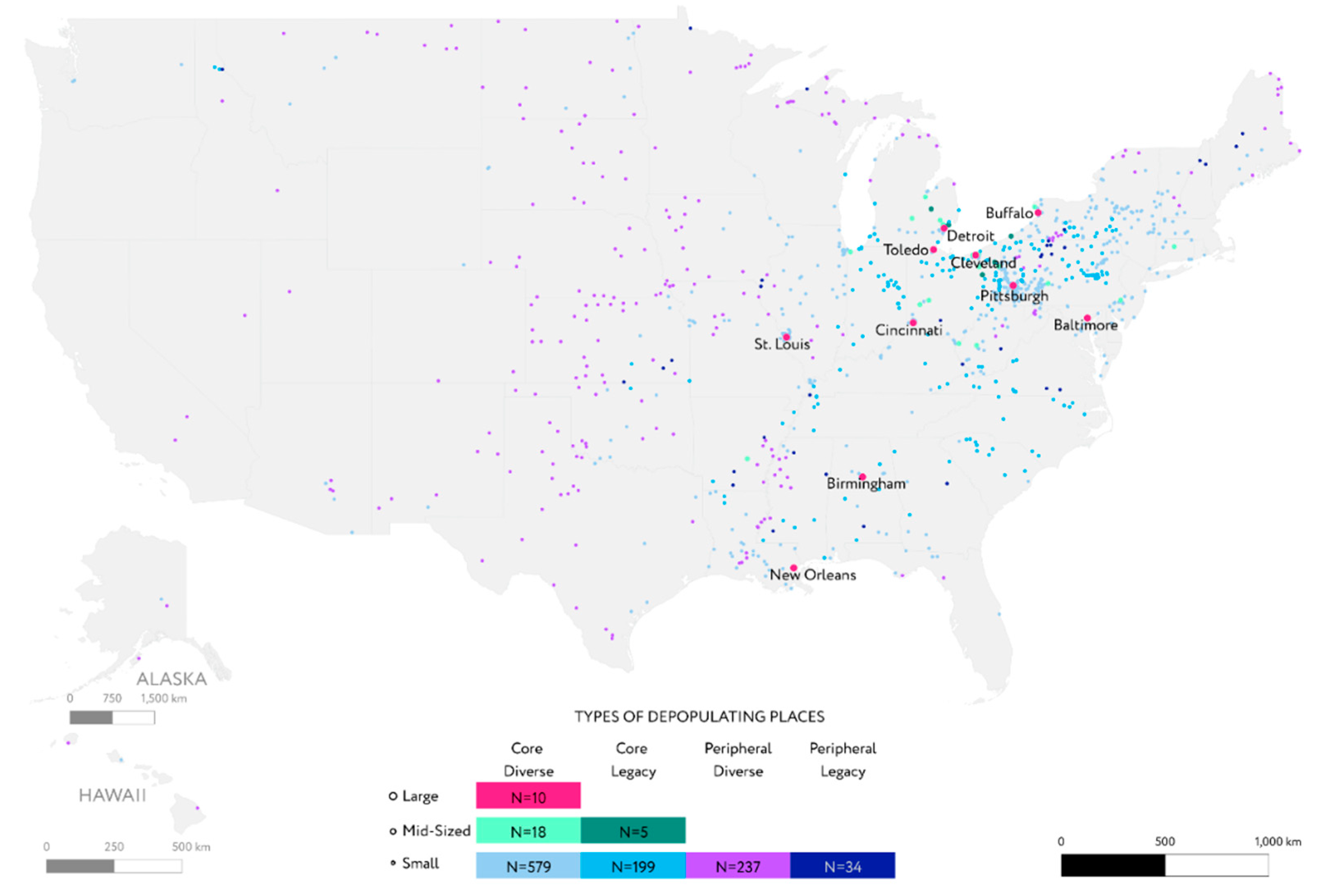
Figure 2.
Maps of depopulating places in the 10 metropolitan areas of Large Core Diverse Cities. Compiled by the authors.
Figure 2.
Maps of depopulating places in the 10 metropolitan areas of Large Core Diverse Cities. Compiled by the authors.
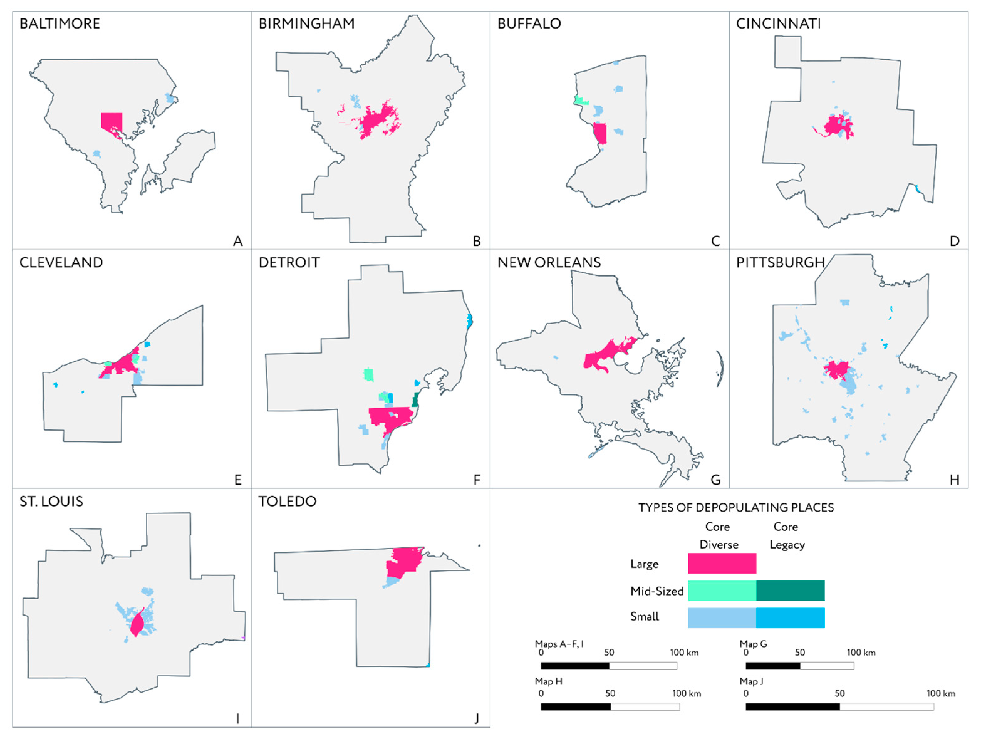
Figure 3.
Share of states in the total number of cities by the three most numerous types, %. Compiled by the authors.
Figure 3.
Share of states in the total number of cities by the three most numerous types, %. Compiled by the authors.
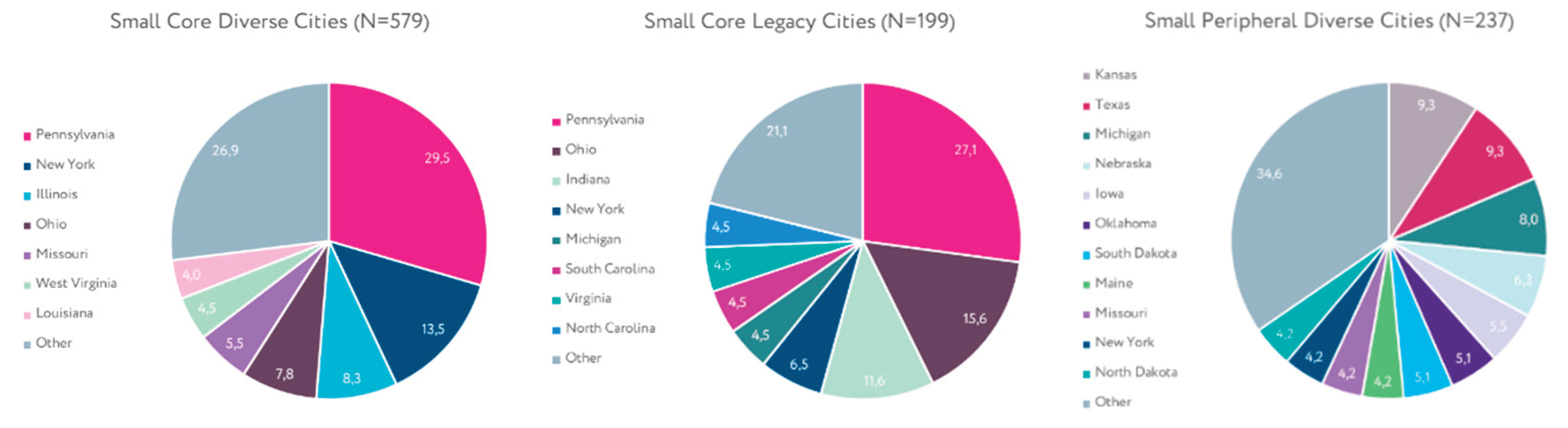

Table 1.
Types of depopulating cities. Compiled by the authors.
| Type | 1990 Population | Distance to the nearest principal city of CBSA | Percentage of residents working in mining and manufacturing in 1990 | N |
| Large Core Diverse Cities | 100,000 and more | Principal city of CBSA | Less than 27% | 10 |
| Mid-Sized Core Diverse Cities | 25,000 to 100,000 | Principal city of MSA/μSA or less than 75 km (46.6 mi) | Less than 27% | 18 |
| Small Core Diverse Cities | 25,000 and less | Principal city of μSA or less than 75 km (46.6 mi) | Less than 27% | 579 |
| Mid-Sized Core Legacy Cities | 25,000 to 100,000 | Principal city of MSA/μSA or less than 75 km (46.6 mi) | 27% and more | 5 |
| Small Core Legacy Cities | 25,000 and less | Principal city of μSA or less than 75 km (46.6 mi) | 27% and more | 199 |
| Small Peripheral Diverse Cities | 25,000 and less | More than 75 km (46.6 mi) | Less than 27% | 237 |
| Small Peripheral Legacy Cities | 25,000 and less | More than 75 km (46.6 mi) | 27% and more | 34 |
Disclaimer/Publisher’s Note: The statements, opinions and data contained in all publications are solely those of the individual author(s) and contributor(s) and not of MDPI and/or the editor(s). MDPI and/or the editor(s) disclaim responsibility for any injury to people or property resulting from any ideas, methods, instructions or products referred to in the content. |
© 2026 by the authors. Licensee MDPI, Basel, Switzerland. This article is an open access article distributed under the terms and conditions of the Creative Commons Attribution (CC BY) license (http://creativecommons.org/licenses/by/4.0/).
Copyright: This open access article is published under a Creative Commons CC BY 4.0 license, which permit the free download, distribution, and reuse, provided that the author and preprint are cited in any reuse.


