Preprint
Article

This version is not peer-reviewed.

Technical Feasibility for Site Selection for Municipal Solid Waste Final Disposal in Chihuahua

Submitted:

27 January 2026

Posted:

27 January 2026

You are already at the latest version

Abstract

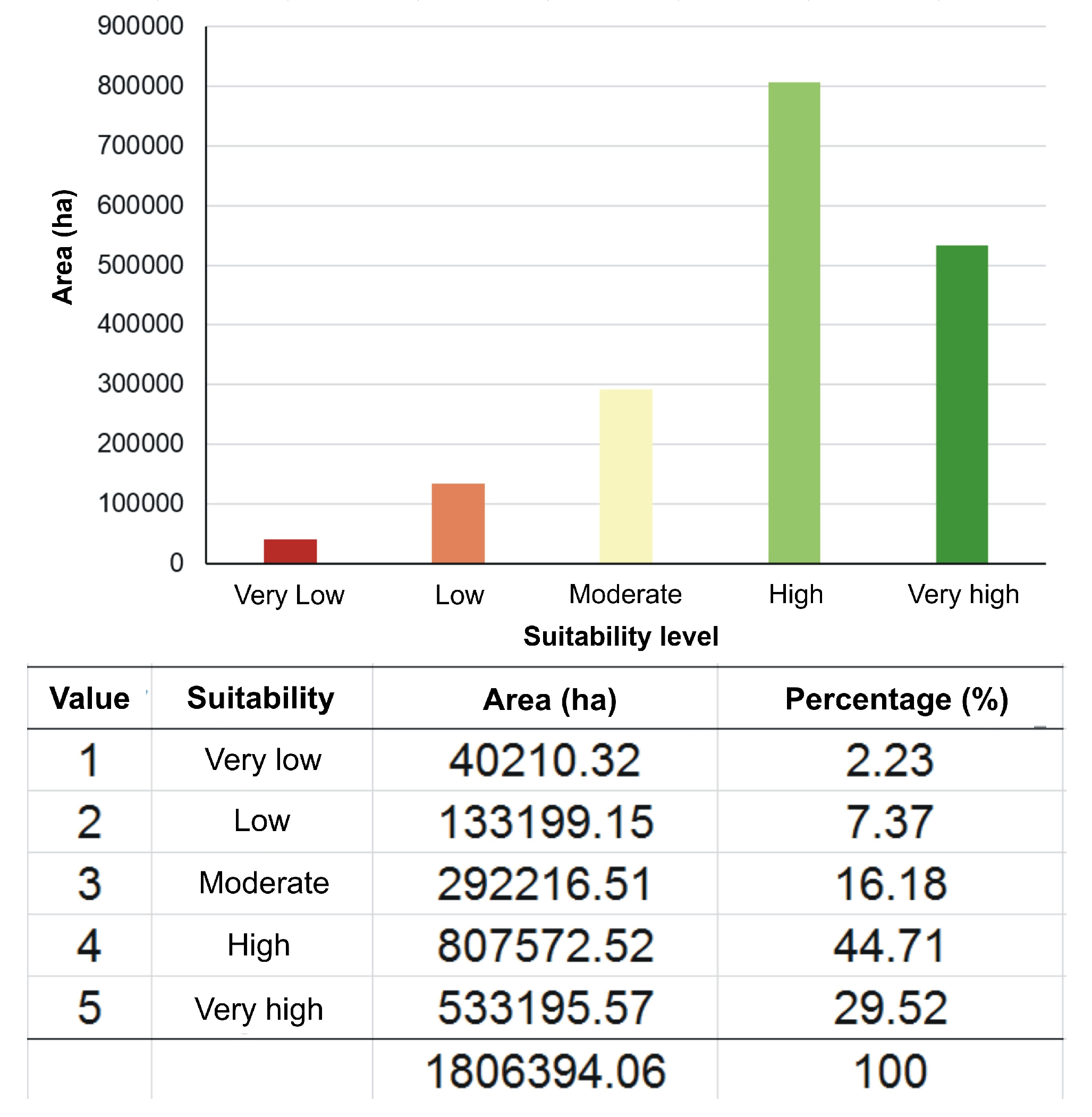
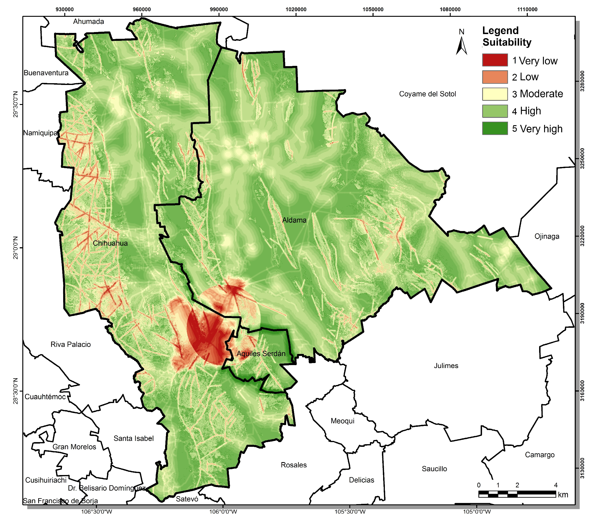
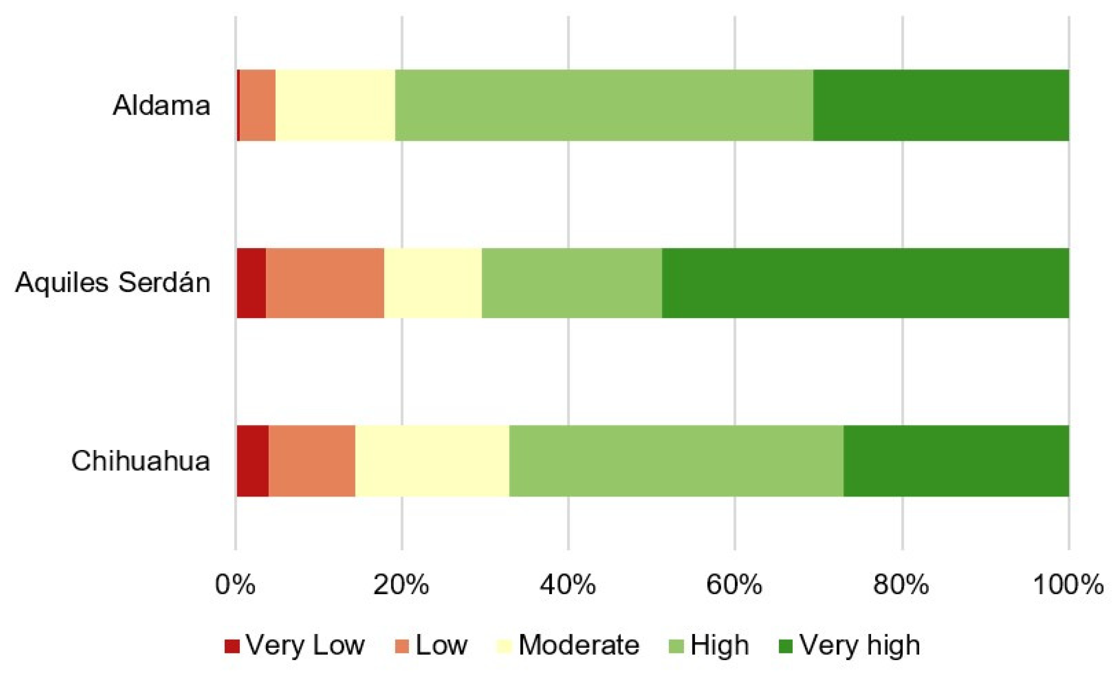
Municipal solid waste (MSW) generation is a global problem affecting the environment and public health. The current landfill’s useful life is reaching its end, making new site selection a priority to guarantee proper MSW management. This research evaluated the suitability of the Metropolitan area in the Chihuahua, Aldama and Aquiles Serdan municipalities, through spatial decision support systems (SDSS) integrated with multi-criteria decision-making (MCDM) and ascending hierarchical analysis integrated to Geographic Information Systems (GIS) to determine potential sites for new Metropolitan landfill development. Results showed that 44.7% of the studied area presents a high suitability level, while 29.52% reaches a very high suitability level. These areas are located mainly in the north and center zones of the Chihuahua and Aldama municipalities, with some isolated Aquiles Serdan areas. The key criteria affecting the selection were: the airport distance, the land slope and proximity to the intermunicipal boundary, which allowed identifying sites with lower environmental impact and higher technical and economic feasibility. This study demonstrates SDSS and GIS are efficient tools to identify potential sites for new landfill location. The results highlight the importance of integrating technical, environmental, and social criteria in planning MSW management, contributing to the region’s sustainable and efficient management.

Keywords: 
;  ;  

1. Introduction

As the population and urban limits increase, municipal solid waste (MSW) production also accelerates. The process to select an optimal site for MSW treatment has become a complex task for local governments, due to the increased rate in waste generation, land possession and cost, the pressure to preserve the land conditions (territorial reserves), fast industrialization, and construction of residential areas. The solid waste generated per person in the world increased between 1995 and 2016. In 2016, cities all around the world produced 2.01 billion tons of MSW. Due to the demographic increase and urban expansion, solid waste generation per year is expected to reach 3.4 billion tons in 2050. The amount of solid waste that has been continuously increasing as the world population increased has become a severe problem all over the world [1,2].
Mostly concentrated in urban areas, the population discard the products which survive their main purpose, and along with the consumerism under an accelerated capitalist economic system, waste generation has become a massive problem. Inadequate waste disposal contributes to environmental pollution, in addition to aggravating public health risks [3,4].
Domestic, industrial, and other types of waste have become a recurrent problem, as they continue polluting the environment. Lack of MSW management provokes environmental issues increasing along with significant local public health problems. The current need refers to the creation of an efficient MSW management system where decision-makers and waste management planners may address the difficulty, uncertainty, multi-objectivity, and subjectivity associated to this problem [5].
Municipal solid waste management has a very important objective, supporting urban planning and development. MSW management is a long process, and it requires schematization of several increasingly complex and interrelated processes, or sub-processes. These include designing collection routes, location of transfer stations, treatment management, and treatment facilities. In MSW management, those responsible for urban planning should establish local and regional objectives in some or all the processes mentioned and later elaborate a management plan [6,7].
The most common MSW management method is storage, as it is more adequate and less costly than composting or incineration; the landfill is a disposal method where waste is initially disposed in fine cells, compressed into small volumes, and finally covered with a layer of soil [8]. Municipal solid waste management needs a regular landfill; one of the most difficult problems in developed urban areas is determining potential sites for an adequate landfill due to the scarcity of land earmarked for waste disposal [9].
The landfill or site must be able to respond to MSW that will be generated in the next 20-40 years. The direct connection to society, environmental effects, political issues, topography, technical and regulatory issues, are some of the criteria increasing the difficulty of selecting the best landfill location. A proper location may reduce landfill construction and management costs [10].
When selecting landfill sites, social, technical, and environmental criteria must be considered, especially the latter, as the landfill may affect the biophysical environment (landscape) and the ecology of the buffer zone. These criteria may vary among regions depending on the local conditions and situations, budget, access to credits, among others. Different criteria must be considered and evaluated to find potential sites for landfill development. An adequate site must have the lower impact on the environment, society, and economy, in addition to being accepted by the population [11].
According to Eskandari et al., (2015), landfill site selection criteria many times include topographical conditions, groundwater, risk levels and types of land use and flora [12]. On the other hand, Baban & Flannagan (1998) analyzed the importance of two main criteria for landfill selection [13]: (1) approval of the local population, regulated by social and political considerations, as well as economic incentives, and (2) technical and engineering protocols for physical environment protection and planning. Some recent techniques intending to address these issues are spatial decision support systems (SDSS), facilitating strategic planning through the participation of multiple interested parties to incorporate contradictory points of view and preferences [14,15].
A type of SDSS is multi-criteria decision-making (MCDM), being the most recent approach used in MSW management decision-making process. The MCDM methods together with Geographic Information Systems (GIS) provide an evaluation of different criteria with a broad understanding of spatial characteristics [16,17,18]. Recently, GIS have emerged as a very useful tool for implementation in landfill selection studies. GIS is an information technology system supporting decision-making with the capacity to manage, analyze, and show data with the land as reference [19].
Integrating MCDM and GIS in decision-making is a powerful tool to solve potential landfill development site selection problems. Multi-criteria decision-making is very efficient for data analysis and new information generation that will be useful in segregating the sites fulfilling local or regional conditions [17,20]. Saaty (1990) proposed the analytic hierarchy process (AHP) as a type of MCDA technique under which a problem is broken down into a hierarchical structure, where the objective is on top [21].
Mexico’s Secretary of the Environment and Natural Resources [22] indicates that in Mexico 102,895 tons of waste are generated per day, out of which 83.93% are collected, and 78.54% reach final disposal sites, recycling only 9.63% of waste produced. As stated by Caballero-Saldívar et al. (2011), in the last six decades [the population has grown significantly], Mexico’s population in 1950 was 30 million inhabitants, reaching 112,337 million people in 2010, and waste generation caused by this increase went from 3 million tons in the 1950s to 40.1 million tons in 2010 [23]. In Mexico, the implementation of landfills went from 95 landfills in 1995 to 184 landfills in 2010. One of the main issues for MSW management in Mexico was establishing landfills complying with the Mexican environmental legislation [24].
There is worldwide pressure to lessen the impact caused by MSW generation. In the 2030 agenda and the Sustainable Development Goals, specifically target 11.6, mentions “by 2030, reduce the adverse per capita environmental impact of cities, including by paying special attention to air quality, municipal and other waste management”. For Mexico, the legislation in charge of regulating under an environmental perspective the site selection, design, construction, operation, monitoring, closure, and complementary works specifications for a municipal and special solid waste final disposal site can be found in in the Official Mexican Standard NOM-083-SEMARNAT-2003 [25]. The standard defines site selection criteria, including the distance to communication routes, urban areas, protected natural areas, airports, surface water, geology, among others. Therefore, landfill site selection is a complex process involving regulatory criteria, the physical conditions of the land, environmental economic, and health conditions, and potential sociocultural impacts.
Specifically, the state of Chihuahua comprises 67 municipalities, out of which only 22 have landfills. Out of these landfills, two are regional. Forty-five municipalities are left without MSW management support. It is estimated that in the state of Chihuahua 0.99 kg/day/person of MSW are produced. Currently the city of Chihuahua produces 1000 tons of MSW per day, comprising 47% of organic waste, 17% paper, 13% plastics, 5% glass, 3% metals, and 15% other materials. 60% of this waste is collected by the Municipal Collection Service and the rest is contracted to different private companies [26]. It is worth clarifying this study was conducted without complying with the Mexican standards recommendations for municipal urban waste generation and characterization, due to the small sample size and random spatial distribution.
Municipal solid waste generated in the city of Chihuahua is transported to its destination, the current landfill (Lat=28.6990907, Long=-106.0394389), with the purpose of controlling, through compaction of additional infrastructures within the landfill, the environmental impacts and thus minimizing the potential public health effects. However, and related to what was declared by SEMARNAT staff in the Chihuahua office, the current landfill’s useful life is about to end (personal communication). Therefore, and in relation to the urbanization and conurbation process, it is necessary to analyze the criteria of the Official Mexican Standard NOM-083-SEMARNAT-2003 for the territory of the city of Chihuahua and conurbated areas of the Aldama and Aquiles Serdan municipalities, along with local criteria (which will be proposed by expert knowledge).
For the reasons above, the purpose of this research is evaluating the suitability of the territory of the Metropolitan area of the Chihuahua-Aldama-Aquiles Serdan municipalities, using SDSS, under MCDM and ascending hierarchical analysis integrated into Geographic Information Systems to determine potential sites for a new Metropolitan landfill development.

2. Materials and Methods
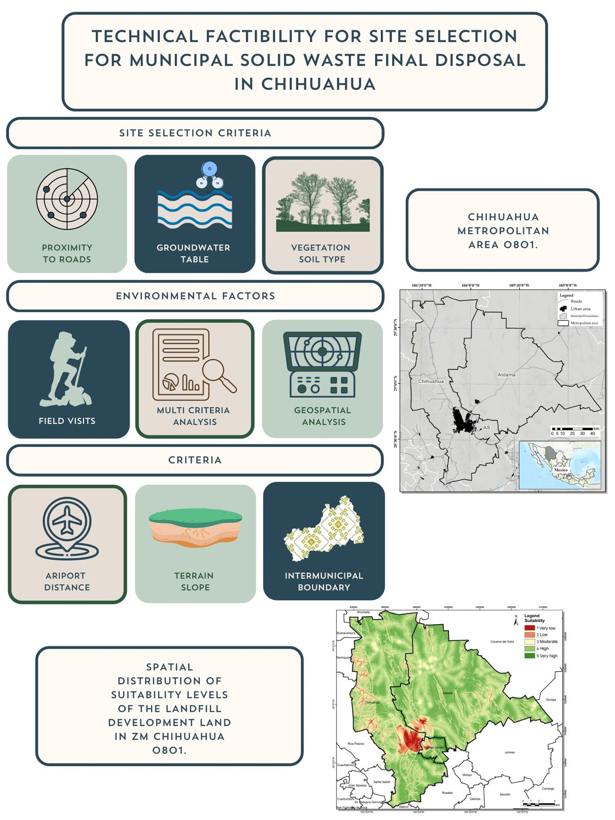
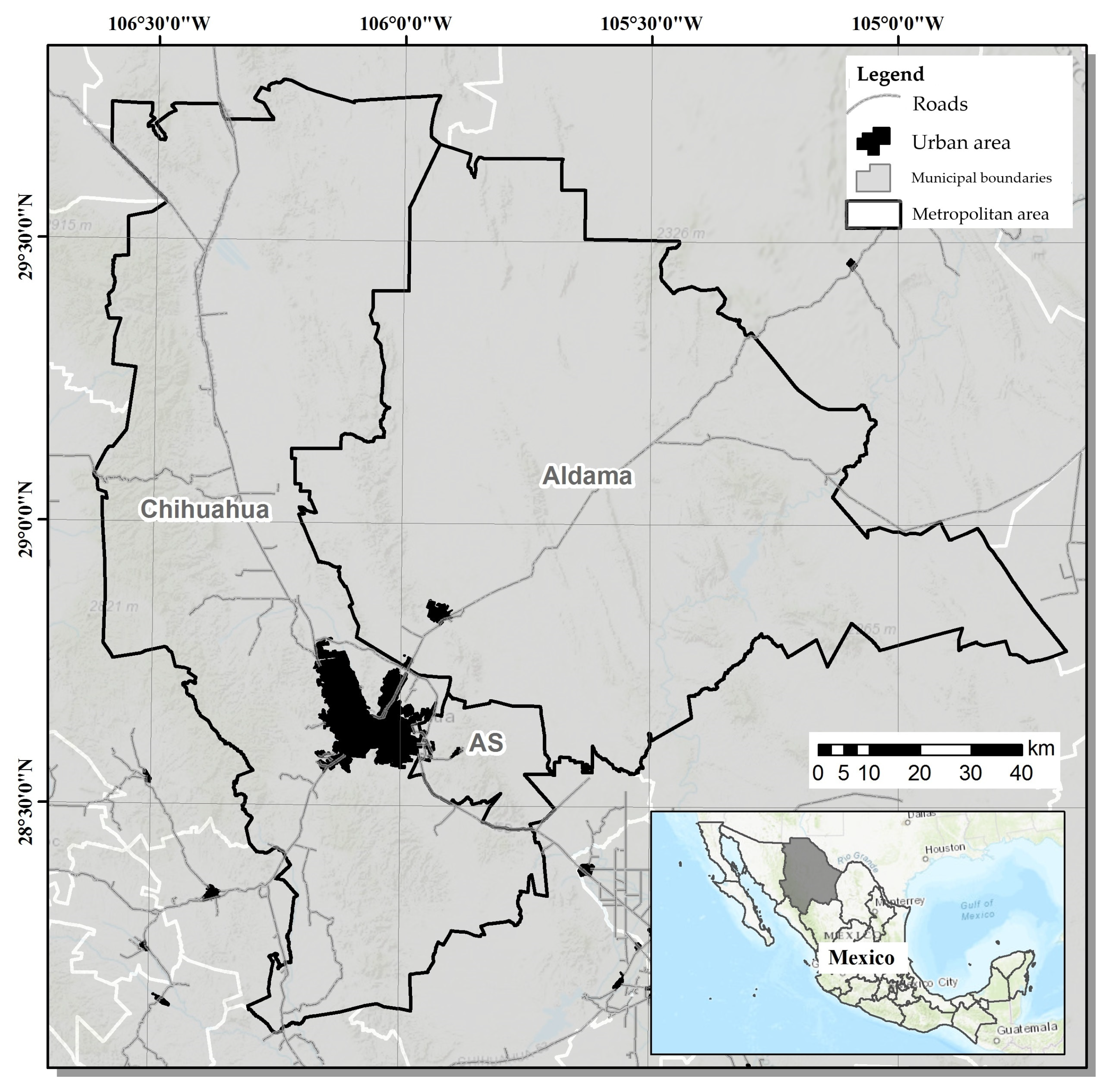
A. Study Area

The study area comprises the municipalities of Chihuahua, Aldama, and Aquiles Serdan, with a population of 937,674, 26,047, and 24,344 inhabitants, respectively, with a total of 988,065 inhabitants in the area (Figure 1). The land area of the municipalities is 836,792.78 ha (Chihuahua), 920,246.39 ha (Aldama), and 49,354.87 ha (Aquiles Serdan). The National Statistics and Geography Institute (INEGI in Spanish), the National Population Commission (CONAPO in Spanish), and the Secretary of Agrarian, Territorial, and Urban Development (SEDATU in Spanish) recognize the Chihuahua, Aldama and Aquiles Serdan municipalities as metropolitan area “ZM Chihuahua 0801” [27]. The municipality with the highest functional integration in relative terms in Aquiles Serdan, where 76.2% of the employed population works in the central municipalities of the Chihuahua metropolitan area.
Regarding the population in the study area, according to CONAPO (2019) population projections by municipality from 2015 to 2030, it is estimated that by 2030 the Aldama municipality will reach 28,581 inhabitants; the Aquiles Serdan municipality will reach a population of 19,383 inhabitants; and the Chihuahua municipality will reach 1,028,134 inhabitants. Together, the three municipalities (ZM Chihuahua 0801) will reach a population of 1,076,098 by 2030.

B. Review of Literature

Official Mexican Standard NOM-083-SEMARNAT-2003 was reviewed to identify the most relevant criteria for establishing the landfill provided in it. Below are listed the minimum requirements provided by the NOM-083 in relation with the site selection stage [25]:
  • When a final disposal site is intended to be located less than 13 kilometers from the center of the airport or airfield providing service to the public, the chosen distance will be determined through an aviation safety analysis.
  • Sites should not be located within protected natural areas, except for the sites provided in the protected natural area management plans.
  • In towns with over 2500 inhabitants, the final disposal site limit must be at a minimum distance of 500 m (five hundred meters) counted from the limit of the existing urban layout or provided in the urban development plan.
  • It must not be in zones with marshlands, mangals, estuaries, swamps, flood plains, river plains, aquifer recharge areas, archeological areas, nor above caverns, nor faults, nor fractures.
  • The final disposal site must be located outside of flood areas with 100-year return period. In case of not complying with the above, it must be demonstrated there will be no flow obstruction in the flood area or possibility of landslides or erosion affecting the physical stability of the works comprising the final disposal site.
  • The final disposal site location minimum distance respect to surface bodies of water such as rivers, lakes and lagoons must be 500 m (five hundred meters).
  • The location between the final disposal site limit and any water extraction well for domestic, industrial, irrigation, and livestock uses, both in operation and abandoned, must be 100 meters addition to the horizontal projection of the greater circumference of the drawdown of wells. When the latter cannot be determined, the distance to the well shall not be less than 500 meters.
Inter-municipality was also considered, as the purpose of the new landfill is providing MSW management for the Aldama and Aquiles Serdan municipalities, both under a conurbation process. In addition to inter-municipality, other criteria based on the local/regional expert knowledge, international bibliography [28,29], the availability of georeferenced data, as well as information from Chihuahua’s and Aldama’s Urban Development Plans (PDU in Spanish), as well as the Chihuahua Municipality’s Local Environmental Ordinance Program (POEL in Spanish) were considered.

C. Criteria Selection

Criteria selection is an important part of the evaluation process of any landfill project. There were 19 selected criteria to determine the landfill development potential sites, observed below in Table 1:
The criteria are shown in different formats (vector or raster) and scales. Before the multi-criteria analysis, they were standardized to a raster format, with a 15 m x 15 m cell size in the ArcMap 10.5© software (ESRI, Redlands, CA, USA; https://www.esri.com/en-us/home). The criteria scale to pixel size ratio is 1:30,000, as per Tobler (1987) [30]. All data provided were projected into a common cartographic projection (UTM 13N) with datum WGS84.

D. Criteria Standardization

For criteria standardization researchers opted for the non-Boolean model (suitability) and complementary water criteria listed by NOM-083-SEMARNAT-2003 [25].
The 15 layers shown in Table 2 were used, these layers were simplified to have only two states: either they fulfill the minimum distance requirement, or they do not (Boolean). Similarly, with the slope layer (grade), a maximum slope angle was determined, representing the state of compliance status.
After that, logical conjunction operations were performed with the 15 layers A 1 A 2 A 3 A 15 pixel to pixel resulting in a binary model: either it complies, or it does not comply the criteria of all layers.
Finally, a modification was made in the airport layer to relax the criteria, as the official standard states it is possible have a site at a distance less than 13 km provided an aviation safety analysis is conducted, that shall be included in the environmental impact statement.
In the non-Boolean (suitability) method, all criteria were standardized in a 1 to 5 scale suggested by the FAO (1976) [31]. Depending on the suitability for landfill development, based on the provisions of the NOM-083-SEMARNAT-2003, each criterion was assigned a suitability value 1 for least adequate through a suitability value 5 for most adequate (Table 3). The suitability levels assigned in this study were: 1 (Very low), 2 (Low), 3 (Moderate), 4 (High) and 5 (Very high), each of them is described in Table 4.

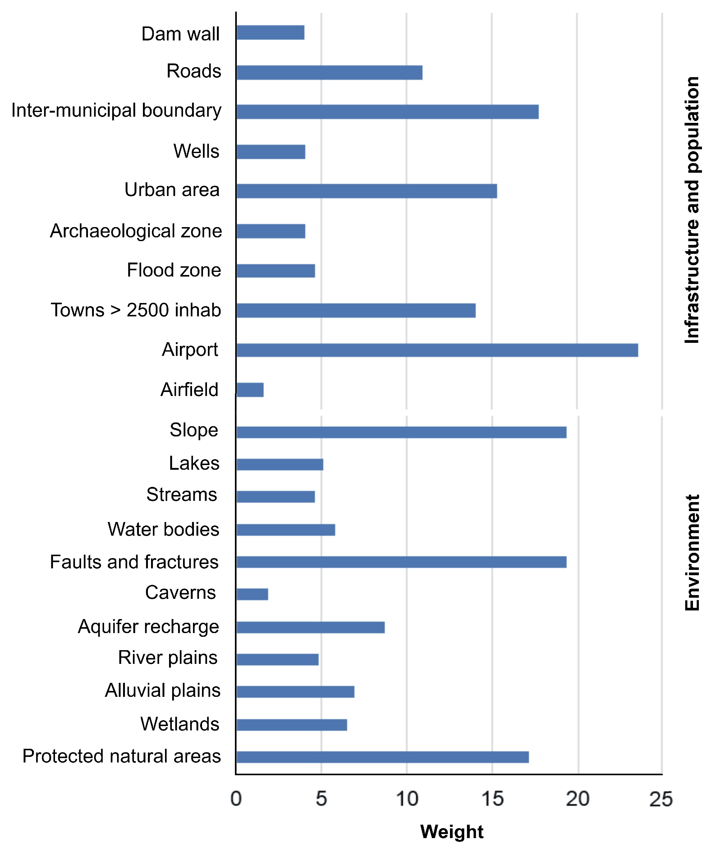
E. Criteria Weighing

Regarding the non-Boolean (suitability) model, the criteria were integrated using the multi-criteria evaluation technique and the geographic information system tool (EMC-SIG). The EMC-SIG is a methodology from which valuable information can be obtained through exploiting and conversion of spatial and non-spatial data, that may help for critical decision-making, based on the expert knowledge of decision-makers. The EMC-SIG requires assigning weight to the criteria.
Weighing has a great importance upon assignment, by example, for scientists focused on the environment, natural resource protection would be paramount, while stakeholders and land developers would prioritize issues such as waste elimination expenses and aesthetic sites of the area of study. On the other hand, civil engineers and soil experts would emphasize the land’s topographical conditions, as neglecting geomorphological criteria could lead the project to failure.
Criteria weighing was calculated through the analytic hierarchy process (AHP) approach. The AHC is a widely recognized decision-making approach for evaluation and selection for sites with determined potential [32]. AHP allows those responsible for decision-making to reach the solution that best suits their many objectives. As decision-makers (land managers, politicians, among others) often have difficulties to determine the relative importance of weighing in complex multi-criteria problems, this mathematical analysis reduces the complexity of the problem to a series of pair comparisons among self-evaluating criteria. AHP also allows considering qualitative and quantitative data in decision-making. Therefore, a decision hierarchy is constructed, breaking down the complex decision problem. Within each level in the hierarchy a pair comparison matrix is constructed, allowing decision-makers to evaluate different elements through comparison of each pair of possible criteria. Comparing two criteria determines the most preferable criteria and the importance level, as much as preferable.
A criterion weight is determined classifying its importance and suitability. Pair comparison evaluation is conducted through expert judgment. The comparison of several criteria may be done using a 9-point scale defined by Saaty (1990) as shown in Table 5 [21]. The importance of criteria uses a scale with values from the 9-point set (1/9, 1/8, 1/7, 1/6, 1/5, 1/4, 1/3, 1/2, 1, 2, 3, 4, 5, 6, 7, 8, 9), ranging from the minimum value 1/9, representing the least important, through 1 representing the same importance, to 9 for the greatest importance. The comparison matrix is a square matrix, in which points are entered above and below the diagonal, while the diagonal values will be 1.
Once weights have been determined, these are used with their corresponding standardized criteria as input for final decision map generation.

F Final Decision Map Generation

Weights assigned to different criteria were processed with the “Weighted Overlay” tool in the ArcGIS 10.5 software, where different criteria and their different weights were combined. This technique has been widely used in previous studies for potential landfill development site selection around the world [33,34,35] and in Mexico [24,36].

G. Comparison with Predefined Sites

Together with the Public Works Office of Chihuahua’s Municipal Government, there were four potential sites preselected, which were compared with the Boolean and non-Boolean suitability model of the Chihuahua-Aldama-Aquiles Serdan municipalities, and if applicable, a recommendation was issued regarding their suitability level. The comparison was made by overlaying in the ArcGIS 10.5 software, between preselected sites and suitability models, generated from criteria established by the NOM-083-SEMARNAT-2003, the inter-municipality criterion, as well as the local/regional expert knowledge, and international bibliography.

3. Results

Selection of potential sites for the new metropolitan landfill included integrating SIG-EMC through AHP. Nineteen criteria for landfill development were used as per the national regulations (NOM-083-SEMARNAT-2003) and data availability.

A. Boolean Suitability Model

The model obtained after modifying distance to the airport was converted to a .kmz file for visualization in Google Earth Pro by the parties involved in site selection (Figure 2).

B. Non-Boolean Suitability Model

Regarding the non-Boolean (suitability) model, pair comparisons made by experts can be observed in Table 6 and 7. In relation with the assigned weights, the distance to the airport is the most important criterion, followed by land slope, faults and fractures, and inter-municipal boundary (Figure 3). This is reasonable, as in first instance, the NOM-083-SEMARNAT-2003, considers as a main restrictive criterion the distance to the airport, and on the other hand, it is important to consider the distance to the inter-municipal boundary, as the new landfill must provide service to three municipalities. In second instance, the presence of steep topography, faults and fractures is a limiting factor for landfill development [25]. Had the above not excluded potential or suitable sites, investment costs for landfill installation would have increased.
Table 6. Matrix of pair comparison for infrastructure and population criteria affecting landfill development. 
Criteria Airfields Airport Towns > 2500 inhab Flood zones Archeological zones Urban layout Wells Inter-municipal boundary Roads Dam wall
Airfields 1 1/8 1/6 1/7 1/3 1/9 1/4 1/9 1/5 1/4
Airport 8 1 2 8 7 2 4 2 3 5
Towns > 2500 inhab 6 ½ 1 4 5 1 2 1 2 6
Flood zones 7 1/8 ¼ 1 2 1/4 2 1/6 1/6 1/2
Archeological zones 3 1/7 1/5 1/2 1 1/6 2 1/7 1/4 3
Urban layout 9 ½ 1 4 6 1 3 1 2 6
Wells 4 ¼ ½ 1/2 ½ 1/3 1 1/4 1/5 1/2
Inter-municipal boundary 9 ½ 1 6 7 1 4 1 3 7
Roads 5 1/3 ½ 6 4 1/2 5 1/3 1 4
Dam wall 4 1/5 1/6 2 1/3 1/6 2 1/7 1/4 1
Table 7. Matrix of pair comparison for physical environment criteria affecting landfill development. 
Criteria Protected natural area Wetlands Alluvial plains River plains Aquifer recharge Caverns Faults and Fractures Bodies of water Water streams Lakes Land slope
Protected natural areas 1 2 3 3 2 4 2 5 5 6 1
Wetlands 1/2 1 ½ 1/2 1/3 3 1/4 3 3 3 1/3
Alluvial plains 1/3 2 1 1 1/4 5 1/2 1/2 3 4 1/6
River plains 1/3 2 1 1 3 1/5 1/5 1/3 1/4 1/4 1/5
Aquifer recharge 1/2 3 4 2 1 4 1/6 1 2 3 ¼
Caverns 1/4 1/3 1/5 1/3 1/3 1 1/6 1/5 1/6 1/6 1/7
Faults and Fractures 1/2 4 2 5 6 6 1 5 5 5 2
Bodies of water 1/5 1/3 2 3 1 5 1/5 1 2 1 1/5
Streams of water 1/5 1/3 1/3 4 1/2 6 1/5 1/2 1 1/2 1/6
Lakes 1/6 1/3 ¼ 4 1/3 6 1/5 1 2 1 1/6
Land slope 1 3 6 5 4 7 1/2 6 6 6 1
The EMC-SIG application with AHP allowed evaluating the area of study suitability for landfill development based on 21 criteria. Thus, it was possible to make a spatial five-level representation in a final decision map, weighted by several experts. Areas corresponding to each level of site suitability are shown in Figure 4. For the High suitability level, under the AHP approach, a land of 807,572.52 ha was obtained, corresponding to 44.71% of occupation of the ZM Chihuahua 0801. On the other hand, regarding the Very High suitability level, an area of 533,195 ha (29.52%) was obtained.
With the non-Boolean (suitability) model based on AHP (Figure 5 and Figure 6), sites with High suitability levels have areas connected between them. These lands area distributed mainly in the northern zone of the Chihuahua and Aldama municipalities. The land corresponding to High suitability level for Chihuahua and Aldama is 334,771.74 ha and 462,098.91 ha, respectively. On the other hand, the Very High suitability level is isolated in the north and center areas of the Chihuahua and Aldama municipalities. In the northern part of these municipalities there are also some areas with this suitability level. The land corresponding to Very High level is 226,346.65 ha and 282,713.68 ha for Chihuahua and Aldama. On the other hand, the Aquiles Serdan municipality has 24,135.19 ha with a Very High suitability level towards the northeast of the municipality.

4. Conclusions

In total, 21 criteria were selected from the Mexican regulation, as well as criteria derived from pertinent literature, and expert knowledge, based on expert judgments, allowing the research to identify sites with high and very high landfill development potential. Each criterion was assigned a weight based on expert knowledge using the AHP approach.
The results of this pre-feasibility study demonstrated the capacity of geographic information systems (GIS) to model and help locate possible new landfill development sites. The GIS allowed identifying the most suitable sites, and it saved time in the search for potential sites in all the area of study. However, the GIS does not replace field verification of sites obtained by the models, as the following step after site selection involves conducting geological, geohydrological, topographical, geotechnical, biogas and leachate generation studies, among others, representing significant expenses.
The ZM Chihuahua 0801 is under industrialization and urbanization process, where municipal solid waste (MSW) management continues acquiring relevance and pressure. However, in developing countries, often “more urgent” matters are addressed first. The increasing population, economic progress and development have given rise to a notable increase of MSW amounts. In the 2030 agenda and the Sustainable Development Goals, Objective 12.5 mentions “Substantially reduce waste generation through prevention, reduction, recycling, and reuse by 2030”, however, though reduction, recycling and reuse are efficient to reduce MSW issues, without additional management measures, such as new landfill development, they will remain insufficient.
Potential landfill development area selection for is a complicated task that must consider environmental, social, technical, economic, aspects, as well as the public opposition to site selection, as it may be subject of controversy. The methodology and approach adopted in this study may be used in other urban areas and in the 45 other municipalities in the state of Chihuahua, and in other municipalities in Mexico. Unfortunately, though, no suitability analyses have been conducted before selected a potential landfill development site in the state of Chihuahua municipalities, which has led or leads to possible project development failure.

References

  1. Kaza, S.; Yao, L.C.; Bhada-Tata, P.; Van Woerden, F. What a Waste 2.0: A Global Snapshot of Solid Waste Management to 2050. Urban Development Series. World Bank Group: Washington, D.C., 2018.
  2. Santhosh, L. G.; Sivakumar Babu, G. L. Landfill site selection based on reliability concepts using the DRASTIC method and AHP integrated with GIS–a case study of Bengaluru city, India. Georisk: Assessment and Management of Risk for Engineered Systems and Geohazards 2018, 12, 234–252. [CrossRef]
  3. Omoloso, O.; Wise, W. R.; Mortimer, K.; Jraisat, L. Corporate sustainability disclosure: a leather industry perspective. Emerging Science Journal 2020, 4, 44–51. [CrossRef]
  4. Palomar, A. A. U.; Sundo, M. B.; Velasco, P. P.; Camus, D. R. D. End-of-pipe waste analysis and integrated solid waste management plan. Civil Engineering Journal 2019, 5, 1970–1982. [CrossRef]
  5. Rahmat, Z. G.; Niri, M. V.; Alavi, N.; Goudarzi, G.; Babaei, A. A.; Baboli, Z.; Hosseinzadeh, M. Landfill site selection using GIS and AHP: a case study: Behbahan, Iran. KSCE Journal of Civil Engineering 2017, 21, 111–118. [CrossRef]
  6. Elahi, A.; Samadyar, H. Municipal solid waste landfill site selection using analytic hierarchy process method for Tafresh Town. Middle-East Journal of Scientific Research 2014, 22, 1294–1307.
  7. Soltani, A.; Hewage, K.; Reza, B.; Sadiq, R. Multiple stakeholders in multi-criteria decision-making in the context of municipal solid waste management: a review. Waste Management 2015, 35, 318–328. [CrossRef]
  8. Sumathi, V. R.; Natesan, U.; Sarkar, C. GIS-based approach for optimized siting of municipal solid waste landfill. Waste Management 2008, 28, 2146–2160. [CrossRef]
  9. Ersoy, H.; Bulut, F.; Berkün, M. Landfill site requirements on the rock environment: a case study. Engineering Geology 2013, 154, 20–35. [CrossRef]
  10. Ojha, C. S. P.; Goyal, M. K.; Kumar, S. Applying Fuzzy logic and the point count system to select landfill sites. Environmental monitoring and assessment 2007, 135, 99–106. [CrossRef]
  11. Kao, J. J.; Lin, H. Y. Multifactor spatial analysis for landfill siting. Journal of environmental Engineering 1996, 122, 902–908. [CrossRef]
  12. Eskandari, M.; Homaee, M.; Mahmoodi, S.; Pazira, E.; Van Genuchten, M. T. Optimizing landfill site selection by using land classification maps. Environmental Science and Pollution Research 2015, 22, 7754–7765. [CrossRef]
  13. Baban, S. M.; Flannagan, J. Developing and implementing GIS- assisted constraints criteria for planning landfill sites in the UK. Planning Practice y Research 1998, 13, 139–151. [CrossRef]
  14. Jankowski, P. Collaborative spatial decision making in environmental restoration management: an experimental approach. Journal of Hydroinformatics 2000, 2, 197–206. [CrossRef]
  15. Jankowski, P.; Robischon, S.; Tuthill, D.; Nyerges, T.; Ramsey, K. Design considerations and evaluation of a collaborative, spatio-temporal decision support system. Transactions in GIS 2006, 10, 335–354. [CrossRef]
  16. Kontos, T. D.; Komilis, D. P.; Halvadakis, C. P. Siting MSW landfills with a spatial multiple criteria analysis methodology. Waste Management 2005, 25, 818–832. [CrossRef]
  17. Sener, B.; Süzen, M. L.; Doyuran, V. Landfill site selection by using geographic information systems. Environmental Geology 2006, 49, 376–388. [CrossRef]
  18. Vasiljevic, T. Z.; Srdjevic, Z.; Bajcetic, R.; Miloradov, M. V. GIS and the analytic hierarchy process for regional landfill site selection in transitional countries: a case study from Serbia. Environmental Management 2012, 49, 445. [CrossRef]
  19. Khan, M. M. U. H.; Vaezi, M.; Kumar, A. Optimal siting of solid waste-to-value-added facilities through a GIS-based assessment. Science of the Total Environment 2018, 610, 1065–1075. [CrossRef]
  20. Allen, B. G.; Caetano, P.; Costa, C.; Cummins, V.; Donnelly, J.; Koukoulas, S.; Vendas, D. A landfill site selection process incorporating GIS modelling. In Proceedings of Sardinia 2003.
  21. Saaty, T. L. How to make a decision: the analytic hierarchy process. European Journal of Operational Research 1990, 48, 9–26. [CrossRef]
  22. SEMARNAT. Residuos Sólidos Urbanos (RSU). Secretaría de Medio Ambiente y Recursos Naturales: México, 2017.
  23. Caballero-Saldívar, D. E.; de la Garza-Requena, F. R.; del Carmen Andrade-Limas, E.; Briones-Encinia, F. Los rellenos sanitarios: una alternativa para la disposición final de los residuos sólidos urbanos. CienciaUAT 2011, 6, 14–17.
  24. Buenrostro Delgado, O.; Mendoza, M.; López Granados, E. Análisis comparativo de tres modelos de soporte de decisiones espaciales en la selección de sitios para rellenos sanitarios en la cuenca del lago de Cuitzeo, México. Investigaciones Geográficas 2005, 57, 21-38.
  25. SEMARNAT. NORMA Oficial Mexicana NOM-083-SEMARNAT-2003, Especificaciones de protección ambiental para la selección del sitio, diseño, construcción, operación, monitoreo, clausura y obras complementarias de un sitio de disposición final de residuos sólidos urbanos y de manejo especial. Secretaría de Medio Ambiente y Recursos Naturales: México, 2003.
  26. Gómez, G. Aplicación de técnicas de ciclo de vida al diseño de un sistema de gestión de residuos urbanos para la ciudad de Chihuahua. Tesis Doctoral, Universitat Rovira i Virgili (URV), España, 2009.
  27. SEDATU- INEGI. Delimitación de las zonas metropolitanas de México. Secretaría de Desarrollo Agrario, Territorial y Urbano Consejo Nacional de Población - Instituto Nacional de Estadística y Geografía: México, 2015.
  28. Gorsevski, P. V.; Donevska, K. R.; Mitrovski, C. D.; Frizado, J. P. Integrating multi-criteria evaluation techniques with geographic information systems for landfill site selection: a case study using ordered weighted average. Waste Management 2012, 32, 287–296. [CrossRef]
  29. Kamdar, I.; Ali, S.; Bennui, A.; Techato, K.; Jutidamrongphan, W. Municipal solid waste landfill siting using an integrated GIS-AHP approach: A case study from Songkhla, Thailand. Resources, Conservation and Recycling 2019, 149, 220–235. [CrossRef]
  30. Tobler, W. Measuring spatial resolution. En Proceedings of the International Workshop on Geographic Information Systems 48; Unión Geográfica Internacional: Beijing, China, 1987; pp. 2–16.
  31. FAO. A framework for land evaluation. FAO and agriculture organization of the United Nations: Rome, Italy, 1976.
  32. Saaty, T.; Vargas, L. Models, methods, concepts & applications of the analytic hierarchy process. In Driven Demand and Operations Management Models; Springer: New York, NY, USA, 2001. [CrossRef]
  33. Barzehkar, M.; Dinan, N. M.; Mazaheri, S.; Tayebi, R. M.; Brodie, G. I. Landfill site selection using GIS-based multi-criteria evaluation (case study: SaharKhiz Region located in Gilan Province in Iran). SN Applied Sciences 2019, 1, 1–11. [CrossRef]
  34. Demesouka, O. E.; Anagnostopoulos, K. P.; Siskos, E. Spatial multicriteria decision support for robust land-use suitability: The case of landfill site selection in Northeastern Greece. European Journal of Operational Research 2019, 272, 574–586. [CrossRef]
  35. Mallick, J. Municipal solid waste landfill site selection based on fuzzy-AHP and geoinformation techniques in Asir Region Saudi Arabia. Sustainability 2021, 13, 1538. [CrossRef]
  36. Durán, C. E. S.; González, O. N. Identificación de sitios con potencial para la disposición final de residuos sólidos urbanos en el municipio de Tepic, Nayarit, México. Revista Internacional de Contaminación Ambiental 2019, 35, 69–77. [CrossRef]
Figure 1. Chihuahua metropolitan area 0801. AS= Aquiles Serdan. 
Preprints 196203 g001
Figure 2. Multi-criteria Boolean model with airport modification (green colors indicate criteria compliance). 
Preprints 196203 g002
Figure 3. Weights obtained from pair comparison under the AHP approach. 
Preprints 196203 g003
Figure 4. Land corresponding the five suitability levels for landfill development under the AHP approach. 
Preprints 196203 g004
Figure 5. Spatial distribution of suitability levels of the landfill development land in ZM Chihuahua 0801. 
Preprints 196203 g005
Figure 6. Landfill development land suitability level occupation percentages by municipality in the ZM Chihuahua 0801. 
Preprints 196203 g006
Table 1. Criteria used in identifying potential landfill development site identification. 
No Criteria Type Unit Group Source
1 Airfields Distance M Infrastructure INEGI
2 Airport Distance M Infrastructure INEGI
3 Protected natural area Distance M Physical environment CONANP
4 Towns with over 2500 inhabitants Distance M Población INEGI
5 Wetlands Distance Physical environment RAMSAR
6 Alluvial plains Categorical N/A Physical environment Own source
7 River plains Categorical N/A Physical environment Own source
8 Aquifer recharge Distance Physical environment CONAGUA
9 Flood zones Distance Infrastructure Own source
10 Archeological areas Distance M Infrastructure Own source
11 Caverns Distance M Physical environment Own source
12 Faults and failures Distance M Physical environment INEGI
13 Bodies of water Distance M Physical environment INEGI
14 Streams of water Distance M Physical environment INEGI
15 Lakes Distance M Physical environment INEGI
16 Urban layout Distance M Infrastructure INEGI
17 Wells Distance M Infrastructure CONAGUA
18 Inter-municipal border Distance M Infrastructure INEGI
19 Land slope Degrees ° Physical environment Own source
20 Roads Distance M Infrastructure INEGI
21 Dam wall Distance M Infrastructure IMPLAN/INEGI
INEGI: National Statistics and Geography Institute, CONANP: National Protected Area Commission, CONAGUA: National Water Commission, IMPLAN: Municipality of Chihuahua’s Integral Planning Institute.
Table 2. Criteria affecting landfill development site suitability integrated to the Boolean model. 
No. Layer Type
1 Slope Angle
2 Faults and fractures Distance
3 Lakes Distance
4 Inter-municipal boundary Distance
5 Airfield Distance
6 Bodies of water Distance
7 Secondary roads Distance
8 Archeological zones Distance
9 Main roads Distance
10 Railways Distance
11 Protected natural areas Distance
12 Urban layout Distance
13 Airport Distance
14 Reservoir Distance
15 Wells Distance
Table 3. Standardization of criteria affecting the landfill development site suitability integrated into the non-Boolean model. 
SV Distance to the airport (km) Protected natural areas Town >2500 inhabitants’ distance (m) Wetlands Alluvial plains River plains Aquifer recharge
1 0-13 0-3000 0-500 0-1000 0 0 0-1000
2 3000-4000 500-1000 1000-1500 1000-1500
3 4000-5000 1000-1500 1500-2000 1500-2000
4 5000-6000 1500-2000 2500-3000 2500-3000
5 13-> 6000-> 2000-> 3000-> 1 1 3000->
SV Inter-municipal boundary Flood zones (100-year return period) Slope (%) Distance to airfields (m) Caverns Faults and fractures Archeological zones
1 2500-> 0-1000 0-5 0-1500 0-100 0-100 0-100
2 1500-2000 1000-1500 5-10 1500-2000 100-200 100-200 100-200
3 1000-1500 1500-2000 10-15 2000-2500 200-300 200-300 200-300
4 500-1000 2500-3000 15-30 2500-3000 300-400 300-400 300-400
5 0-500 3000-> 30-> 3000-> 400-> 400-> 400->
SV Bodies of water (m) Lakes (m) Dam wall (m) Water extraction well (m) Water streams (perennial) (m) Urban layout Roads
1 0-1000 0-1000 0-1000 0-500 0-1000 0-500 0-70
2 1000-1500 1000-1500 1000-1500 500-1000 1000-1500 500-1000 70-100
3 1500-2000 1500-2000 1500-2000 1000-1500 1500-2000 1000-1500 100-200
4 2500-3000 2500-3000 2500-3000 1500-2000 2500-3000 1500-2000 200-300
5 3000-> 3000-> 3000-> 2000-> 3000-> 2000-> 300->
SV= Suitability value.
Table 4. Definition of suitability levels for landfill development sites [31]. 
Suitability level Value Description
Very high 5 Zones without significant limitations for sustainable landfill development
High 4 Zones without significant limitation for sustainable landfill development. It may include minor modifications that do not affect the productivity or benefits and without increasing inputs above an acceptable level
Moderate 3 Zones with overall moderate limitations for landfill development; these limitations will reduce productivity or benefits and will increase necessary inputs to the point the global advantage obtained from its use, although still attractive, will be significantly lower to what is expected in highly suitable areas.
Low 2 Zones with generally bad limitations for sustainable landfill development. These limitations will reduce productivity or benefits or will increase necessary inputs.
Very low 1 The land has limitations that may be overcome with time; limitations are severe and would hinder the successful and sustainable use of this area for landfill development.
Table 5. Values used in pair comparison to evaluate new landfill site suitability. 
Verbal judgments of preference between alternatives Numerical classification (importance or intensity) Explanation
Extreme preference 9 Tests favoring one criterion over another are the highest possible order
Very strong preference 7 One criterion is very strongly favored, and its domain is demonstrated in practice
Strong preference 5 Experience and judgment strongly favor one criterion over another
Moderate preference 3 Experience and judgment slightly favor one criterion over another
Same preference 1 Two criteria contribute equally to the objective
Intermediate value 2, 4, 6, 8 When intermediate judgment is needed
Disclaimer/Publisher’s Note: The statements, opinions and data contained in all publications are solely those of the individual author(s) and contributor(s) and not of MDPI and/or the editor(s). MDPI and/or the editor(s) disclaim responsibility for any injury to people or property resulting from any ideas, methods, instructions or products referred to in the content.
Copyright: This open access article is published under a Creative Commons CC BY 4.0 license, which permit the free download, distribution, and reuse, provided that the author and preprint are cited in any reuse.
Prerpints.org logo

Preprints.org is a free preprint server supported by MDPI in Basel, Switzerland.

Subscribe

Disclaimer

Terms of Use

Privacy Policy

Privacy Settings

© 2026 MDPI (Basel, Switzerland) unless otherwise stated