
Submitted:
21 January 2026
Posted:
23 January 2026
You are already at the latest version
Abstract
This study investigates the continuity, change and discontinuity of human settlements in the northern Stig Plain along the Danube River in Serbia, with the aim to explore how the natural environment, human–land interactions, and historical events shaped the establishment, duration, decline, and reconstruction of these settlements. Particular attention is given to the Roman city of Viminacium, now largely covered by fertile farmland. The research combines theoretical perspectives on landscape and human–land relations with a review of sources on Roman urban development, case studies of settlement formation, development, abandonment and transition, and an analysis of Viminacium’s environmental and historical context. It examines why Viminacium remained the landscape’s only major urban centre, with no subsequent settlement built directly above it. Findings show that the natural environment strongly influenced settlement patterns, providing both subsistence and strategic advantages. The plain’s urban potential was fully realised only in the Roman period, through the establishment of a legionary fortress, technological advances, organised labour, and military order that overcame environmental constraints. Viminacium’s heritage integrates remains from multiple historical periods into a unique, evolving cultural landscape that warrants preservation, though its management remains challenging.
Keywords:
landscape
; Viminacium
; human-land relations
; urban settlement
; discontinuity
; continuity
; change
; Roman settlement
; Danube
; cultural landscape
1. Introduction
Very often, prehistoric settlements occupied the same locations as those of today. There is no location favorable to human life and activity that people have not discovered over the course of history and settled. Even when fleeing and emigrations lead to the complete abandonment of an area, new settlers tend to return to and reoccupy the same places. Humanity has therefore consistently clustered around certain points and areas of attraction, first forming a small nucleus around which additional human layers accumulate, much like the crystallization of matter in the inorganic world. Once gathered, people, through labour and ingenuity, enhance natural resources and increase the value of the geographical position of a place. This, in turn, attracts others who seek to benefit both from the natural resources of the area and from the added value created by human activity. Thus, human agglomerations grow and develop (Jovan Cvijić, 1922) [1].
Human interaction with the environment and the dynamics of settlement patterns over time are central to understanding past landscapes [2]. The selection of sites and the foundation with development of settlements largely depended on human–land relationships [3] and on the advantages or constraints offered by the environment. Although the reasons for the destruction, reconstruction, or final abandonment of settlements varied over time, natural conditions most often played a decisive role in these processes.
Viminacium was the capital of the Roman province of Moesia Superior (later Moesia Prima) and an important legionary fortress on the Danubian frontier – Limes, founded in the 1st century AD [4,5,6,7]. Today, it is an archaeological site and park located in the Stig Plain near the confluence of the Mlava and Danube rivers in Serbia, close to the city of Požarevac [7]. (Figure 1). Although being looted in search for valuable objects by local residents, and deconstructed for centuries in order to use material for new purposes [8], significant archaeological remains of Viminacium’s narrow territory still lay beneath the fields of the present-day villages of Kostolac, Drmno, and Kličevac while its outskirts disappeared in recent decades due to surface coal mining (Figure 2).
The first official archaeological excavations of Viminacium were conducted in 1882 [9] and continued in 1902–1903 [10]. After a long hiatus marked by small-scale systematic research, large-scale protective excavations began in the end of the 1970s ahead of the construction of a thermal power plant. These excavations held by the early 1990s, uncovered the large southern necropolises, with the burial time span from the 4th century BC to the 16th century [11,12,13,14,15]. Continuous systematic and protective archaeological research with excavations has been conducted since the beginning of the 21st century using modern survey technologies [7]. To date, only limited areas of the city of Viminacium and its legionary fortress have been researched. Research has focused primarily on wide areas outside the fortified city and fortress that were threatened by strip coal mining and the construction of a thermal power plant complex, where villas with estates, water-supply facilities, and necropolises—containing more than 14,000 graves—have been documented [6,7,16]. Excavations of the fortified area have uncovered parts of the ramparts, towers, and principia of the fortress, as well as sections of the residential areas, street network, the public baths and the amphitheatre [7] (Figure 3).
Since 2006, the excavated remains of Viminacium have been protected, presented, and interpreted within an archaeological park equipped with modern scientific, service, and visitor facilities and supporting infrastructure. The creation of the park was initiated by researchers and has involved the local community in its development [17,18,19,7,20,21] (Figure 2 and Figure 3).
It was noted in 1928 that Roman antiquities were not only found around Kostolac, but traces of Roman settlements existed in nearly every village or its surroundings. The region’s dense population throughout the centuries was reflected in the saying that “once a cat could walk from roof to roof, from the Danube to the south, in two days” [22] (p. 23). Although Viminacium was once a large Roman city, no settlement was established above it in later history, leaving its underground remains accessible for contemporary transdisciplinary research. Additionally, since the Roman period and the development of Viminacium and its surrounding estates in the northern part of the Stig Plain, no settlements have been established elsewhere in the plain [23]. Necropolises from the Bronze Age, Roman period, and Middle Ages have been detected in the plain [24], while subsequent villages were founded only at the foot of the ridges bordering it.
In the periods after its final decline in the 7th century, the structures of Roman Viminacium were dismantled, and their architectural fragments and building materials were reused in the construction of medieval fortresses, monasteries and rural setlements, as well as in numerous houses in surroundings in later periods [25,8]. On the plateau above the village of Kostolac, at the end of the Požarevac Ridge – the so-called Sopot Ridge, and in the immediate vicinity of the today Viminacium archaeological site, the medieval town of Braničevo was established. The village of Kostolac likely developed during the Middle Ages at the western edge of ancient Viminacium but was presumably relocated to the left bank of the Mlava River in the 18th century, near the foothill of the Sopot Ridge, encompassing the wider area of Braničevo suburbs (25-26). Together with a 19th century mining colony established near the underground mine on the opposite side of the foothill, and subsequent spatial expansion to the south, this area eventually formed the present-day village of Kostolac [26] (Figure 1 and Figure 2).
The nearby town of Kostolac developed further after World War II, continuing the expansion of the small German mining colony [26], eventually becoming the municipality of the City of Požarevac. Požarevac, originally a small medieval village, experienced rapid growth under Ottoman rule in 16th century and became a significant town in the 19th century, serving as the seat of a Serbian prince [25]. Coal exploitation, combined with electricity production in thermal power plants, affecting villages of Drmno, Kostolac and Kličevac, has been particularly influential for the economical development of the region in the last five decades, but it has also caused the permanent loss of many agricultural fields and archaeological remains from various periods [25] (Figure 1 and Figure 2).
In this study, we seek to examine comprehensively the area of Viminacium archaeological site as a landscape. Some scholars argue that a landscape is simply the environment, regardless of human presence, while others contend that it is human activity that transforms the environment into a landscape. A third perspective combines these two views, aiming to scientifically explain human adaptation within the natural environment while interpreting meaningful human actions through the lens of the humanistic sciences [27]. This study aligns with the latter perspective; however, it represents only a foundation for future comprehensive analysis. It offers an interpretation through a humanistic lens that can be integrated with findings from other scientific disciplines.
Studying landscape development is essential not only for understanding natural conditions, settlement patterns, and human–environment relations, but also for their planning, management, conservation and protection. Such research helps protect landscape values while identifying risks and key “reference thresholds” and significant ongoing changes [28] (p. 2455). The present study represents one component of the broader analysis required for the preservation of Viminacium landscape, within a comprehensive transdisciplinary study anticipated in the future. We do not seek to define the boundaries for this landscape in the study, as any strict delimitation would disregard the contextual and spiritual connections in it that extend beyond such defined limits.
Each settlement within the landscape of Viminacium held particular regional significance in its respective period and followed a distinct developmental trajectory. This study examines the influence of various factors on settlement life within the Viminacium landscape from the Roman period to the present day. It aims to explore how the natural environment and the human–land relationship along with historical events shaped the construction, duration, deconstruction, and reconstruction of these settlements. Particular emphasis is placed on Roman period, which left the most intriguing imprint on the landscape.
The Roman army played a major role in the urbanisation of Western Europe, as many legionary fortresses developed into modern cities. However, most fortresses along the lower Danube and in Dacia did not follow this trajectory [29]. As Watkins further notes, few fortifications downstream of present-day Vienna left a lasting imprint on the street networks of modern cities. While some Roman camps occupied strategically advantageous locations that continued to be used for fortifications in later periods—such as Singidunum, home to the IIII Flavia Legion, situated on the hill above the confluence of the Sava and Danube in today Belgrade—others, including Brigetium (Hungary) and Carnuntum (Austria), as well as Viminacium, are now villages [29].
Few modern cities in the former Roman provinces built apon the Roman remains still retain significant parts of the ancient street network, as is the case in Italy. In the provinces, in contrast, there are Roman cities largely untouched for centuries - unlike most Italian cities, except those destroyed by Vesuvius - above which no new settlement developed [30], whether they were developed near the fortresses or founded as individual entities. Examples across the Roman Empire, among others, include the above-mentioned Carnuntum [31,32] and Troesmis (Romania) [33,34] on the Danube frontier, Stobi (North Macedonia) [35,36] in the heart of a province, Calleva Arebatum (England) [37,38] at the distant British Isles, as well as Thamugadi (Algeria) at the outskirt of the African desert [39,40].
The reasons for the absence of developed urban life after the Roman period in some of the cities have not been fully clarified. They may include major natural disasters or environmental changes, invasions and destruction, economic collapse, infrastructure decay, loss of site significance, or other as yet unexplained factors, but we also need to comprehend the transition of the ancient to the medieval societies and its impact on urban life. Thus, this study seeks to get closer to the reasons of the absence of an urban settlement above Roman Viminacium.
2. Materials and Methods
To achieve the aims of this study, contemporary theoretical approaches to landscape studies and human–land relationships are presented. Following an overview of the natural conditions and settlement patterns in the Viminacium landscape—supported by relevant sources, literature, and maps—selected case studies and scholarship on settlement development and transitions after the Roman period are discussed. This is complemented by a review of historical sources concerning the establishment of Roman settlements and urban development.
2.1. Theoretical approaches to landscape studies
Landscape archaeology, or the archaeology of landscapes, offers the possibility of gaining knowledge about past ways of life while also helping to understand how the past continues to influence the present. This approach primarily relies on field survey data combined with interpretation developed through interdisciplinary collaboration. According to Fairclough, landscape archaeology can be pursued through three types of study, either individually or in combination. The first treats the landscape as a “tool” or “scale” for understanding the past; the second focuses on the nature of the landscape in the past, that is, how people experienced and perceived it; and the third examines the historic character of the present-day landscape, exploring how traces of the past shape contemporary perceptions of the landscape [41] (p. 479).
Walsh argues that, when investigating interactions between people and the environment, it is essential to consider the choices societies made regarding settlement location, landscape management, selection and extraction of natural resources, as well as the impact of these activities on the landscape. Through this approach, we identify and explain changes in both society and the environment. Some settlements were inhabited continuously for centuries or even millennia, while others were abandoned for shorter periods and later reoccupied, while in some others we need to consider the forms of inertia, change, and adaptation [43]. Adaptation and resilience are one of the most discussed terms in today climate change science and policy. Adaptation mostly refers to actions that reduce the harmful effects of climate change, but also to changes in natural and human systems as a response to the impacts, while resilience is the capacity of people, places, objects and infrastructure to withstand and adapt to climate risks [42]. This concept is used to examine how humans and other living beings respond to global and habitat changes, especially those with negative effects. While resilience often refers to the ability to recover from “adversity, change, or threats to their sustenance”, it can also imply perseverance or limited adaptability, according to Lawrence [43] (p. 152). Walsh uses the concept of resilience, which does not imply maintaining equilibrium but rather the development of societal strategies that ensure survival and prosperity of the settlements [44].
The contemporary climate change adaptation frameworks often fail to adequately define risk, explain human vulnerability, or address how risk management can reinforce social inequalities. For this reason, risk assessments must clearly reflect where, how, and by whom risks are experienced [42]. Adaptation involves interconnected processes that sustain “being human” before, during, and after global and local changes, and it results are shaped by dynamic “biological, ecological, cultural, social, and individual human processes” [43] (p. 152). Although it is customary to distinguish between landscapes of pre-industrial societies—often considered stable and slowly evolving—and the rapidly changing landscapes of the modern era, every landscape has its own unique characteristics, according to Renes. The regions were never truly stable; however, the idea that they are in a state of constant change cannot be fully accepted as well, since periods of relative stability have always alternated with periods of transformation. Therefore, landscapes should be understood as dynamic entities that can never be preserved in their entirety. Preserving landscapes thus means managing change [45]. Developed in the 1990s by English Heritage, the Historic Landscape Characterisation (HLC) programme provides a method for identifying and interpreting the changing historic character of English landscapes for planning and management. It recognises that landscapes are not merely products of change, but that continuous change—whether rapid or gradual—is central to their character. Landscapes are inherently dynamic, and management should guide change rather than attempt to conserve landscapes. All landscapes are historic, valuable, and capable of being managed appropriately [46].
Landscape development is commonly studied from two perspectives: reconstructing past landscapes through the analysis of historical layers preserved in the present, and interpreting the current landscape as the outcome of multiple historical layers shaped by human activities and ecological processes [47]. However, Holtorf and Williams argue that these perspectives of landscape “focused on reading its character and evolution” [48] (pp. 253–254), although “valid” for the studies of the recent past, are insufficient for archaeology, as the meanings landscapes held for past societies cannot be fully understood without considering the memories associated with them. As they note, in reality, nearly all landscapes are historical, having been “altered, inhabited, visited or interpreted by people” [48] (pp. 235). However, the label “historical” is often reserved for societies with written sources. Furthermore, so-called “historical landscapes” cannot be only those shaped by humans, since natural landscapes are frequently understood as the work involving past people, or supernatural power [48] (pp. 235–236). Landscapes are therefore inseparable from socially constructed memory. For this reason, the authors consider the term accumulative landscapes, defined as “landscapes composed of the traces of human action and natural features that form the focus of retrospective memories” [48] (p. 236).
Archaeology within the landscape leads to the concept of the archaeological landscape, which Daróczi describes as a “reconstruction in motion”—a depiction of how the landscape might have appeared from a specific perspective defined by a distinct group of archaeological finds or features within a well-defined spatial and temporal context of aspects of past human experiences [49] (p. 200). Landscapes change during the time through human and natural processes, making them “complex spatial forms” composed of many elements, such as land use, settlement patterns, populations, production sites, infrastructure, and administrative organization, whose values vary across past, present, and future contexts [28] (p. 2444). The European Landscape Convention, adopted in Florence in 2000, defines landscape as “an area, as perceived by people, whose character is the result of the action and interaction of natural and/or human factors”. It emphasizes its contribution to the shaping local cultures and the role within ecological, cultural, and social contexts, and identifies changes in the global economy as key drivers of landscape transformation. The Convention recognizes not only outstanding landscapes but also everyday and degraded ones [50].
The concept of the cultural landscape was included in the UNESCO Operational Guidelines in 1993 as “combined works of nature and of man,” “illustrative of the evolution of human society and settlement over time, under the influence of the physical constraints and/or opportunities presented by their natural environment and of successive social, economic and cultural forces, both external and internal” and “embraces a diversity of manifestations of the interaction between humankind and the natural environment” [51 (par. 36)-52 (par. 47) ]. Cultural landscapes, according to one of the scholarly definitions, “clearly represent or reflect the patterns of settlement or use of the landscape over a long time”, but also “the evolution of cultural values, norms, and attitudes towards the land…They grow out of continual readjustment of human aims and hopes in the light of environmental forces. Thus, these landscapes exhibit, either conspicuously or subtly, long-held values of their area or culture” [53] (p. 56), as quoted in [54] (p. 149).
In the field of human ecology as “the study of the mutual interconnections between people and their environments at multiple scales and multiple time frames” [55] (p. 880), we must comprehend humans as much as biological organisms as social beings [56]. From a human ecology perspective, settlement processes both affect and depend on natural biosphere cycles, relying on resource availability and waste export to sustain populations [57]. Human ecology is represented by Dyball and Newell as “a systemic framework for understanding complex human/social and environmental/biospherical systems in terms of fundamental ethical principles concerning access to and uses of natural and human-made processes” [58] (p. 123). As such, it represents one of the most important interdisciplinary fields in today’s world, which is faced with the challenge of balancing extensive human activity with the preservation of nature.
3. Results
3.1. Natural conditions, resources and environment of Viminacium landscape
The territory of today Serbia has been consistently inhabited since prehistory. The Central Balkans, i.e. most of present-day Serbia, was an important route linking Southwest Asia with Central and Western Europe, but also an important “ecological and social refugium” for humans during difficult periods. People most often settled in river valleys, lowlands and low hills, while higher hills and mountains were more inhabited during the Palaeolithic and Metal Ages. Thus, in addition to various events and social conditions, the populations in prehistory at this territory were strongly shaped by the availability of food and mineral resources [59] (p. 7)
The terrain of Viminacium is characterized by two ridges (lower Požarevac Ridge and higher Boževac Ridge) between which lies the Stig Plain [60] in which Roman fortress and city of Viminacium developed on a slightly elevated plateau above the Danube (Figure 1). On both sides of the western, Požarevac Ridge, are the coal fields of the Kostolac Coal Basin, while the alluvial deposits of the Mlava and Morava rivers form some of the most fertile land in Serbia, suitable for cultivating a variety of crops, particularly cereals [61]. The Basin lies on the southern edge of the Pannonian Basin and has a temperate continental climate with pronounced steppe influences from the neighbouring Banat region, characterised by cold winters and warm summers [62]. A notable climatic feature of the Kostolac area is a very strong wind known as the košava [61]. The Košava is a southeasterly wind originating in the Carpathians that brings dry, cold conditions and strongly influences the local climate. It occurs mainly in autumn and winter, with average speeds of 25–45 km/h and gusts up to 70 km/h [63]
The natural and climatic conditions of the area have been favourable for agriculture to the present day [64] (Figure 4). The Stig Plain was the most fertile area of the Roman province of Moesia Superior [65]. The territory of present-day Serbia was primarily agrarian in Roman period and only sparsely urbanized, but it also hosted significant imperial estates and mining operations, with their administrative centers located in Viminacium. Grain production was likely one of the main branches of agriculture in the region, and sources mention Moesia, along with Dacia, as provinces capable of supplying themselves with agricultural products. However, research on the supply systems of the Roman army indicates that grain and food production in Moesia Superior was insufficient to sustain both the local population and the military stationed there. This shortfall was therefore supplemented by imports from other parts of the Empire [64].
Stig was also a well-developed agricultural region during the Middle Ages, as evidenced by the Ottoman Braničevo region tax register from 1467, which records various products as payments in kind made by the local population to the Ottoman authorities [66]. In the later period, Stig became renowned for both maize and wheat, and until the Second World War, agricultural products from Braničevo and Stig were exported along the Danube to Europe [67]. In 1936, records indicate that the areas sown with wheat and maize were equal, ensuring food security even if one crop failed due to climatic conditions. This practice was attributed to the long agricultural experience of the local population [67]. Vineyards existed on the slopes of the Sopot Ridge in the Middle Ages [66] and continued in the following centuries [22,68]. In 1936, the best vineyards in the wider region of eastern Serbia were recorded precisely on the Sopot Ridge [67]. Today, vineyards occupy relatively small areas [63].
Owing to the exceptional quality of the soil, agriculture in the whole Požarevac area continues to achieve strong production results today, as demonstrated by consistently high wheat yields on family farms, which remain above the averages for both the Republic of Serbia and the modern Braničevo District [69]. Currently, arable land dominates the agricultural land structure (97.8%), with fertile soil types accounting for 99.3% of the total area [63]. However, contemporary surface coal mining in the Kostolac Coal Basin has led to the occupation of extensive land areas and the destruction of habitats across all biocenoses, from forests to agricultural landscapes [70].
Apart from the Mlava and Danube rivers and the springs along the surrounding ridges, the Stig Plain is relatively poor in water, and its largest creeks nearly dry up during the summer months [24]. The scarcity of water, combined with persistent strong winds, led rural settlements to develop primarily along the river and springs, despite the recurring risk of flooding, while the plain itself was used as arable land. During the excavations of Viminacium in 1882, it was observed that the land north of the city was frequently flooded [9], while other 19th century documents likewise record flooding in the Viminacium area caused by the Danube and the Mlava [71]. The Mlava River flooded the area until the 1980s, when its riverbed was relocated and an earthen embankment was constructed for the purposes of building the thermal power plant in Drmno village [72]. In more recent times, although protected by embankments, the Mlava has also flooded the village of Kostolac and nearby settlements [73,74,75].
The wetland character of the area north of the location of the Viminacium city and the fortress toward the Danube is embodied in the toponym “Rit” (marsh) [24]. The drainage at “Rit” was undertaken during the Roman period [76,77]. In 1936, it was noted that near Veliko Gradište—most likely referring to the area east of the nearby village of Ram, situated at the edge of the eastern ridge of the Stig Plain —there was a marsh covering approximately 16 km² that “had a detrimental effect on the health of the local population, who frequently suffered from fever.” Furthermore. the “quicksand” near Ram (Ram-Zatonje sands – Figure 5) consisted of extremely fine sand deposits resembling dust that were carried over long distances by the košava wind and were considered “harmful to health, particularly to the respiratory system” [67] (pp. 36-37), while “mercilessly destroying crops” at the same time [78] (p. 167). As forest clearing and grazing increased wind erosion, it was avised to plant trees, since vegetation provides the strongest defense against wind and the sand it carries [79].
***
The use of local materials was a fundamental principle of Roman construction [80] and was consistently applied in ancient Viminacium, where the principal building materials consisted of locally manufactured bricks and green schist quarried nearby at Ram [81]. During the earliest phases of Viminacium camp and settlement, wood was widely used as evidenced by excavated building remains [82,83,84]. The extensive oak forests that covered the area until the 19th century provided a supply of this material [67]. Willows and poplars were also widespread, as well as hornbeam, and sporadically beech [85]. Archaeobotanical research of the remains of the wooden structure of the Viminacium amphitheatre [86] showed that they mostly belong to beech, followed by hornbeam, ash and oak to a much lesser extent [87].
In the Roman period, stone exploitation depended largely on the availability of suitable resources near cities and access via roads [88]. Local stone was used for building blocks, decorative slabs, lime production, and aggregates [89], while material from distant sources was employed only in exceptional cases, such as imperial projects [88]. Some quarries were closely linked to the cities they supplied and later disappeared beneath urban expansion, whereas others were abandoned after a single phase of use or remained in continuous use from prehistory to the present [90]. The schist bed at Ram, near Viminacium site, belongs to this last group. Schist was used in Roman Viminacium and later in the Ottoman fortress at Ram (Figure 6), as well as in local houses and monasteries of the wide area [25]. Although the exact Roman quarry locations are not precisely determined, the entire Ram area was likely exploited, with later construction obscuring earlier evidence [25].
Earth has long been widely used in the construction around the world—for mortars and plasters, floors, roof waterproofing, brick production, wattle-and-daub and rammed-earth techniques, and modern wall blocks [89,91,92]. The abundance of loess with high clay content in much of the Viminacium area [93] enabled continuous production of ceramic building materials in Roman Viminacium [25]. Bricks and tiles produced on an almost industrial scale by the Viminacium army, were used locally and supplied settlements along the Danubian Limes [94,95,96] (Figure 7). In the wider Viminacium zone—largely destroyed by surface mining (at the local holy “Svetinja” site around which an eastern Viminacium necropolis formed, and was used from the 1st to the 4th century AD - [97])—19th-century sources record former extensive Roman clay extraction for brickmaking, a practice that local villagers continued for house plastering [9]. Traditional wooden and mud-built houses in medieval Braničevo suburbs [98] and 19th-century Požarevac villages [99] reflect this long-standing building practice, while fired brick became predominant in the village again by the late 19th and early 20th centuries and its production flourished in the local factories of the Požarevac region [67]. Additionaly, in many rural households, raw materials were excavated, kneaded, and dried on-site, and bricks were fired for personal use [69], but the craft has since largely disappeared [25].
The mineral resources of Moesia Superior were of major economic importance to the Roman Empire [100]. Although eastern Serbia was rich in gold, silver, lead, iron, and copper, such resources were absent near Viminacium, which was instead characterized by coal deposits. There is no evidence of coal exploitation in the Viminacium area before the 19th century [25]. A distinctive local material, “crvenka”, found adjacent to the coal seams in the Kostolac area, was widely used as a building material in several periods [8]. Formed by the metamorphism of sedimentary rock caused by coal combustion [101], it occurs in the Sopot Ridge near the former Kostolac underground mine [25] (Figure 8). The Romans used crvenka in road construction and wall cores, particularly before large-scale brick production and during later economic crises, when it provided a cheap and accessible alternative [8,25]. It has also been identified in the structures of the nearby Roman town of Margum [102]. Until recently, crvenka was still used for industrial road surfaces and for producing building blocks in a local plant [81].
***
According to European Union standards and experience, the Kostolac area is classified as an environmentally polluted and degraded zone, with adverse effects on human health, flora and fauna, and overall quality of life [69]. The fertile agricultural areas of the Stig Plain have been steadily declining for decades due to the expansion of industries, and although some degraded land has been reforested, restored with natural vegetation, converted back to agricultural use, or even planted with vineyards, overall reclamation and revitalisation efforts remain largely unsatisfactory [69]. Although the territory of the City of Požarevac lies within the zone of continental mixed forests and forest-steppe, forest cover is limited and now accounts for only 7% of the territory [63,103]. This is primarily the result of forest clearing for agricultural expansion and the lowering of groundwater levels caused by coal exploitation [63]. Natural vegetation is largely reduced to small tree groups, individual trees, and hedgerows along field boundaries [70]. Former indigenous forest communities have largely been replaced by grassland meadows. Along the banks of the Mlava and Danube rivers, tree species characteristic of riparian environments dominate, while reeds prevail in floodplains, wetlands, and waterlogged areas. [93].
The Danube and its branch, the Dunavac, form Kostolac Island, which has been divided into three sections through artificial interventions and intersected by drainage canal systems [69]. The River Mlava originally flowed into the Dunavac, but following industrial interventions in the mid-20th century, it was redirected to flow directly into the Danube via the canal [62]. The construction of the Đerdap Hydroelectric Power Plant raised the water level of the Danube, causing more frequent flooding of its right bank and necessitating the construction of flood embankments in the area [62]. During the last few years, the Dunavac riverbed has been gradually destroyed by coal exploitation, as has the former Mlava riverbed, and their former confluence has disappeared (Figure 2).
The negative impacts of thermal power plants and their associated facilities include large emissions that pollute air, water, and soil, as well as the generation of waste materials and waste heat [69]. In the strip mine zone, gases are released through coal oxidation, and dust is produced during dry and windy conditions [62]. Surface coal exploitation affects groundwater levels and may consequently impact overlying structures, both ancient and modern [63]. Additionaly, the vibrations caused by heavy mechanization can impact buried archaeological remains. In 2008, microtremor monitoring was conducted to identify zones most affected in Viminacium by the operation of the nearby thermal power plant (Figure 9) and to assess resulting degradation. The study estimated a permanent damage rate of 1.2% to underground archaeological structures per decade [104]. Buried archaeological remains are also increasingly threatened by climate change, including floods, droughts, storms, erosion, and fires [105]. One research included an analysis of landscape changes at the Roman city of Troesmis on the Danube in Romania, from the 19th century to the present, aimed at assessing degradation and informing protective measures, proving that the methodology needs to combine historical and modern topographic and geological maps, aerial photographs, and field surveys documenting resource extraction, erosion, construction and agricultural development [33]
Surveys conducted in 2016 and 2017 of the village settlements affected by strip mining and energy activities in the Viminacium area highlighted the critical role of environmental conditions in settlement sustainability. Kostolac has largely avoided the loss of arable land, whereas agricultural land in Kličevac has been reduced by half, and that of Drmno has almost entirely disappeared due to strip mining. Because Drmno and Kličevac lie on the edge of the strip coal mine, they experience the most severe mining impacts, while Kostolac and Drmno are more strongly affected by the work of thermal power plant. In Kličevac, about 55% of respondents support relocation if conditions do not improve. Key requirements for staying include improved infrastructure, safe drinking water, sewage and heating systems, regulated waste disposal, employment—especially for youth, better public and health services, stricter environmental controls, and transparent environmental monitoring [106]. In Drmno, 98% support relocation due to health risks, uncertainty for children, loss of the land and property damage. Financial constraints and ties to property have kept most of them from moving; 28% prefer to move to urban areas, and only 6% wish to remain in a rural setting, but agriculture is largely considered unviable due to soil, water, and air contamination. However, historically, these residents accepted partial land expropriation in exchange for employment opportunities [107].
3.2. Roman Viminacium
3.2.1. History
The earliest evidence of settlement in the Kostolac area dates to the 6th millennium BC and the Late Neolithic. The most prominent Late Eneolithic culture, the Kostolac culture, was identified at a site on the edge of the Sopot Ridge, along with later Early and Late Iron Age settlement remains [108]. The necropolis dated to period from the late 4th to the early 2nd century BC was uncovered at the site of “Pećine”, which is one of the archaeological sites forming southern Viminacium necropolises [5,109]. Archaeological finds can indicate that a Scordisci settlement was situated on the Sopot Plateau, dated to the late 2nd to the mid or late 1st century BC. Along the foothills of both ridges surrounding the Stig Plain, as well as within the northern part of the plain itself, graves from the Late La Tène period or finds indicating the existence of settlements engaged in farming and animal husbandry, have been discovered [108,110]. Archaeological evidence can indicate that the Celts and later the Scordisci formed a stable and economically advanced community in the area of later Roman Viminacium. Following the Roman conquest, cultural exchange occurred in both directions [110].
Legio VII Claudia is generally credited with constructing the military camp of Viminacium after arriving in Moesia from Dalmatia in the 1st century AD [5]. Although some scholars suggest that Legio IIII Flavia Felix may have been stationed there first, withdrawing later due to Domitian’s ban on stationing two legions in a single camp [4], scholars leaves the possibility of stationing both legions in Viminacium at some point [111]. During Domitian’s Dacian campaigns, Viminacium became the most important fortress on the Moesian bank of the Danube. In 86, Moesia was divided into Moesia Superior and Moesia Inferior. Viminacium played a key role in Trajan’s Dacian Wars (101–106), serving as the main assembly point for legions and crossing of the Danube near the fort of Lederata during the First War [5]. Following Trajan’s victory, Dacia became a Roman province, and Moesia Superior ceased to be a frontier region [112]. Canabae legionis developed near the Viminacium fortress very early [6]. Municipium status was gained under Hadrian in 117 and colonia status with coinage rights under Gordian III in 239 [5]. Viminacium emerged as the leading military, political, and economic centre on the Lower Danube. The stationed legion participated in campaigns under Septimius Severus and Caracalla. During the political and military crises in the second half of the 3rd-century, Viminacium supported troops and emperors traveling east [5] and likely suffered after Gallienus punished those who supported a rebellion among Moesian and Pannonian troops [4]. After the solution of the crisis in 284 under Diocletian, Moesia Superior was divided, with Viminacium serving as the capital of Moesia Prima. It became the episcopal centre in the 4th century [5]. The city was traversed by Goths around 380 [113] and later devastated by the Huns in 441, who plundered it and enslaved its population [4]. It was gradually reoccupied by Germanic tribes while displaced residents gradually returned to the ruined city [5], and it likely came under Gepid control afterwards while formally remaining within the Eastern Roman Empire [4]. Rebuilt under Justinian as a border fortress in the 6th century, Viminacium was briefly captured by the Avars in 584 but mentioned again around 600 as a Byzantine military base. Viminacium likely ceased to exist in the 7th century following large Slavic incursions [4].
Population mobility was a defining feature of Roman cities, and DNA analyses show that Viminacium was a cosmopolitan centre as many cities were at the time. Despite prolonged militarization, genetic input from Italic populations was minimal, while a substantial influx of Anatolian ancestry occurred between 1 and 250 CE. Between 250 and 550 CE, migrants from Central and Northern Europe and the Steppe are detected, followed after the collapse of Roman rule by the large-scale arrival of populations genetically similar to modern Eastern European Slavic speakers. However, complete demographic replacement did not happen, as substantial Iron Age Balkan and Anatolian ancestry persists from the medieval period to the present [114].
3.2.2. Planning and Construction
Roman urbanism followed a set of principles whose origins predate the founding of Rome [115]. From the 8th–7th centuries BC onward, Greek colonization across the Mediterranean promoted the use of orthogonal street grids dividing cities into rectangular blocks, a system formalized by Hippodamus of Miletus in the 5th century BC. Around the same time, the Etruscans developed a rectangular street layout influenced by close commercial and cultural contacts with the Greeks. Archaeological evidence from the city of Misa, beneath modern Marzabotto in Italy, confirms this practice. Unlike Greek examples, Misa combined an orthogonal grid with strict alignment to the cardinal points, a feature likely linked to foundation rituals later adopted by the Romans. Roman urban planning merged their military camp model defined by two main intersecting roads: the north–south cardo and the east–west decumanus, with gates at their ends, with the grid system. Some scholars, however, argue that urban planning influenced the layout of military camps rather than the reverse [116].
The Romans divided the conquered land to determine fees and taxes, and developed colonies, utilising the grid system of squares and rectangles, featuring two main settlement streets of the cardo and decumanus. Created areas defined property rights, designated land for cultivation and public use, and strengthened administrative control in conquered regions, while also providing the framework for the layout of the built environment [117]. The orientation of the street grid in Roman colonies could follow several criteria, including alignment of a main axis with prominent landscape features, the general direction of the coastline, or pre-existing routes such as major connecting roads. Practical considerations—such as watercourses, marshes, and flood risk influenced urban layout [116,117], as well as the “health criteria”, particularly prevailing winds [115] (p. 73). Where geographical constraints were minimal, settlement orientation could also incorporate astronomical observations and symbolism linked to significant political or religious dates [117].
Considering the camps and forts, ancient sources generally state that a main gate, or Porta Praetoria, should face the enemy, which consequently led to considerable variation in forts orientation. Nevertheless, their main axes typically aligned roughly along the ideal north–south and east–west directions, with deviations caused by practical environmental factors [118]. Based on the orientation analysis of dozens of Roman settlements in Italy they conducted, scholars concluded that Roman urban planning cannot be explained by a single factor. Settlement layouts reflected a complex process that combined symbolic, astronomical, environmental, and political considerations, closely linked to the creation and enforcement of new political and ideological orders across territories over time [117].
The orientation of Roman towns according to the wind direction should have helped mitigate natural nuisances, such as wetland odours. More importantly, it aided in dispersing urban odours from people, animals, and insufficient sanitation [25]. In Roman cities, wastewater was directed into nearby watercourses, but faeces and waste often remained in the streets [119]. The Greek physician Athenaeus of Attalia (1st c. AD) noted that congested cities caused unhealthy air, while free airflow improved health, digestion and appetite. Sabinus emphasized that ideal city situated in the plain should have straight streets leading to the suburbs to allow winds to carry away smoke and fumes [120].
Comparing the wind rose for the Viminacium area with the fortress’s axes shows that the decumanus aligns with the direction of the strongest southeast wind, the košava (Figure 10). The fortress of Viminacium with the later city was built on the edge of a river terrace, above a wetland and marshy area north of the zone. While the fortress southern position in relation to the marshy area generally shielded it from its odours carried by the winds, calm periods likely allowed unpleasant smells to spread. To mitigate these nuisances—both from the marsh and the fortress itself—a strong wind was needed to blow down the streets unimpeded, which the košava provided. In the 1920s, it was noted that the košava wind could tear off roofs and uproot trees, and that people had difficulty walking against it. Although it was considered harmful—especially to fruit—it was also believed to be beneficial to health, as at lower altitudes it dried ponds and removed moisture from yards and houses [22]. Thus, the Viminacium fortress orientation, with the northern gate facing the Danube, due to strategic-military reasons, followed the typical north–south and east–west street directions but included a deviation of about 20º, likely influenced by the strongest wind direction [25,121] (Figure 10).
The Roman practice of planning cities with regular square or rectangular blocks was widely applied in Italy and across the provinces. However, it was not strictly followed in practice [25]. Thamugadi - Timgad, a city originally designed with a precise block layout, developed an irregular grid as it expanded, and it seems that the plan that “was binding on the first builders”, “lost its power within a very few years”, whil Aquincum (Budapest) grew gradually to the city from a smaller settlement, not being founded all at once, exhibited “no true street-planning”, slowly developing “as best it could” [30].
In 1902 a 5 m-wide street in Viminacium city running parallel to the fortress long axis—north–south—likely serving as a cardo was excavated [10]. In the recent years, an east–west street, the decumanus, has been researched [122]. The city, which developed west of the fortress, generally followed the fortress main orientation (southeast–northwest after a slight deviation), but not all streets adhered to this pattern. One major city street was connected to the fortress decumanus via the western gate but deviated from its direction [25]. Geophysical surveys of Viminacium [6] and aerial imagery indicate that the city grid, developed along an earlier road-later decumanus, which formed a city zone most clearly visible in geophysical images, was irregularly oriented relative to the fortress street grid and prevailing wind direction. The rest of the city grid, though not fully recognisable on the images, suggests prevailing alignment with the fortress layout. Notably, the excavated public buildings—the city baths and amphitheatre—have main axes that align with the fortress. The major city street spreading from the west fortress gate roughly connects the gate to the area where today “Selište” site near the Mlava River stands (Figure 10). This alignment may reflect an еxistence of an earlier route linking the camp to some important spot at the area. Strategic importance of the Stig Plain location near the Danube determined the construction of the legionary fortress of Viminacium. However, the rapid rise of urban settlement in the first half of the 2nd century, was not solely due to its role in communications and defense, it also reflected the pre-existing economic development by the indigenous population, whose workshops continued operating under Roman rule [109]. After fortress establishment, veterans and merchants settled around it [4]. Their initial position could have been along the mentioned road.
The location of the indigineous settlement; the development of the canabae with merchants, artisans, and soldiers’ families; Municipium Aelium Viminacium as a civil settlement with limited rights; and colonia as the highest urban category, as well as their mutual spatial relationships and connections to the development of the fortress, along with the evolution settlement on both the left and right banks of the Mlava, and the Sopot Plateau, remain insufficiently researched. To date, these issues have been addressed by many authors [4,11,108,111,112,123] but future archaeological excavations will undoubtedly provide valuable data for further study. The colonial status of Viminacium underscores its importance in the Roman period, as the elevation of existing cities to colonies or the foundation of new ones served to reflect the glory and power of Rome in the provinces [29]. Although local specificities influenced the development of Roman cities, Viminacium undoubtedly shared similarities with legionary fortifications and cities on the Lower Danube that underwent the same historical events and held a similar importance [124].
Research at Viminacium wider zone has confirmed the eastern of the city’s three main road connections linking the city to the rest of the Empire: likely part of the eastern route linking Italy with the Black Sea [125]. A series of ancient sites, with numerous villas and a suburban settlement have been archaeologically researched east of the city, indicating a densely populated area [76,126,127,128,129,130]. Located on gentle slopes and plateaus in the fertile Danube hinterland, springs, forests, pastures, fertile soils, and loess suitable for vineyards made this area attractive for economic buildings and residences owned by wealthy citizens of Viminacium [130].
***
Historical discourses from Vitruvius onwards include guidance on the ideal placement of settlements, mostly highlighting the need for a temperate climate with air that is neither excessively hot nor cold and fresh winds, as well as the importance of situating cities in areas with plentiful water resources [131].
Hstorically, water supply systems evolved from individual wells and cisterns to short-distance pipes and eventually to long-distance transport via canals, tunnels, or bridges—a practice of aqueducts that became widespread during the Roman period [132]. Aqueduct networks were particularly important in densely populated areas lacking abundant local water. Economically, proximity to roads and markets often mattered more than nearby water sources when choosing production sites [133].
Viminacium’s water supply is evidenced by detected and excavated aqueducts: gravity channels (Figure 11), whose slopes follow the profile of the Stig Plain (apparent from comparing their routes - [134] (T. XXII-XXIII), and the plain’s cross-section - [23] (p. 15), as well as related structures, that primarily served public buildings, wealthy houses, and possibly some insulae. Related structures in Roman aqueduct supply include basin structures (castella) for water intake, sedimentation, regulation, pressure reduction, storage, and distribution. Parts of one of these systems, along with gravity channels, were uncovered in Viminacium [135]. Built in the 1st century and used until the 4th century, the Viminacium aqueducts’ water source and construction—whether fully subterranean—remain unknown [136]. Travel writers, researchers who excavated the aqueduct remains and relocated them before the area was lost to strip-mining [134], as well as local inhabitants, have suggested different locations for the spring. All proposed sites are located in the zone southeast of Viminacium, at the foothills of the eastern Boževac Ridge of the Stig Plain, an area rich in springs [24,135,137,138]. At the foothills of the western Sopot Ridge, which also contains springs, though in smaller numbers, traces of aqueducts—presumably supplying the nearby Roman town of Margum—have been discovered [138].
Within the Viminacium city, two wells excavated in 1902 date to the earliest wattle settlement and to the early 2nd century, respectively. This area, along the road that began from the western fortress gate, later developed into a mixed residential zone with workshops, street-facing shops, and houses [10]. The mix of domus and insulae is typical of Roman cities, where houses often had shops or taverns facing the street, contributing to the owner’s wealth [139]. East of Viminacium, at the site “Nad Klepečkom”, the estates relied on wells for water supply; the wells have been identified in a necropolis, economic settlements, and villas, one of which also featured a rainwater collection system [135]. Numerous wells were also excavated at the site of “Rit” [77,72,141] (Figure 12). Wells were sufficient to meet basic domestic needs—providing water for drinking, hygiene, cooking, and washing dishes and clothes—while rainwater collection systems were likely used as an additional resource [135]. One study has shown that water supplied from wells was adequate to meet the needs of maintaining gardens and animals within a single villa, whereas livestock could also drink from natural springs or nearby rivers [135]. Agricultural fields were primarily irrigated by rainfall. Considering that the aqueducts of Viminacium are known to have ceased functioning in the 4th century, it can be concluded that later inhabitants relied on wells and probably cisterns for rainwater collection to meet their water needs. Aqueducts were primarily important for large urban centers and public buildings, while individual households could function without them. However, the example of Londinium (London) is particularly illustrative: the city’s water supply relied entirely on wells and springs, as well as the river, and not the aqueducts. Given that the geological layers of Londinium are comparable to those of Viminacium, this comparison offers an interesting basis for further consideration of Viminacium’s water-supply system, not only after the 4th century but also in earlier periods [135]. Since aqueducts were most important in cities lacking local water—which can be said for the Stig Plain—their use was likely essential for sustaining the large and growing urban population of Viminacium.
***
Traces of prehistoric settlements have been identified at several sites in the Viminacium area [142]. The “Rit” site and the site “Nad Klepečkom”, former situated a wetland near the now non-existing Klepečka River and latter on a terrace above it, both contain prehistoric remains [77,128,143,144]. The altitudinal distribution of Eneolithic finds from the “Rit” site suggests a rise in water levels during this period, indicating a shift of settlements from low-lying, flood-prone zones to higher elevations. In contrast, Bronze Age and Iron Age finds indicate lower water levels, making habitation at “Rit” possible once again [145].
The “Rit” site was in a wetland, and the valley was crossed by the Klepečka River, which has since dried up; its course can now only be traced through the terrain. The proximity of these rivers was crucial for the establishment of early prehistoric settlements, initially along the Klepečka River, and later for ancient and medieval settlements. Prehistoric and medieval artifacts are sporadically found on flood-resistant elevations along the river. However, in the Roman period, an organised drainage system had been established, reflecting the settlement’s reliance on effective water management [140]. Excavations at the “Rit” site confirm that the area was drained by canals in the 2nd century and densely inhabited in the 3rd century, with several excavated trench segments interpreted as drainage channels (Figure 11). Residential buildings from the 2nd and the 3rd century were uncovered, and 4th-century finds were recovered from a vertisol layer up to one meter thick, representing the ground surface. It is assumed that drainage maintenance ceased in the end of the 3rd century, leading to the wetland restoration and the later toponym “Rit” (marsh). However, at this site the settlement from the 9th century was discovered as well [72,76,77,140,143].
From the late 1st century BC to the end of the 2nd century AD (Pax Romana), Roman cities grew and suburbs expanded largely along roads [146]. City walls were generally rare, often serving more as status symbols than practical defenses [147]. Procopius notes that along the Danube frontier, the emperors built fortifications not to make them impregnable, but to ensure that the riverbank was never left unguarded, as the barbarians were unfamiliar with attacking fortifications, which were therefore mostly towers staffed by small crews [148].
Excavations of Viminacium indicate that the city ramparts were erected along the amphitheatre after the middle of the 2nd century AD enclosing it in the city fortified inhabited area [149]. Comparable fortification occurred in cities such as Salona, where suburban areas and key structures, including the amphitheatre and port, were enclosed within new walls around 170 AD. This limited urban expansion, leading to taller buildings, narrower streets, and frequent additions to houses [146].
Following barbarian invasions in the third quarter of the 3rd century, Roman fortifications were gradually rebuilt, previously unfortified cities were walled, and some settlements disappeared. Many cities declined in Late Antiquity due to inadequate defenses, leading to abandoned or repurposed public buildings, reuse of materials, and the emergence of isolated graves or small cemeteries within former urban areas. Several cities shrank significantly, as it was no longer possible to defend long city walls. Whether the decision to rely on city fortifications rather than forts and legions was imperial policy or driven by local circumstances must be examined on a case-by-case basis [147].
Military-political events of the late 3rd century also affected Viminacium and instabilities during this period likely caused devastations within the city [150]. At the beginning of the 4th century, Viminacium’s city baths underwent major renovation and expansion, although some areas abandoned at the end of the 3rd century were never restored. The baths remained in use until the end of the 4th century, when they were permanently abandoned following a fire possibly linked to sudden riots [150,151]. By the end of the 3rd or early 4th century, Viminacium amphitheatre lost its primary function and, from the mid-4th century, it was used for burials [149]. The suburban “Rit” site was abandoned in the 280s [72] and the population of Viminacium consolidated within the city walls [72].
Archaeological research at the Viminacium legionary fortress has identified two main phases: an early phase dating to the late 1st century, during the reign of Domitian, and a later phase beginning in the early 2nd century under Trajan and Hadrian, which continued through several stages until the fortress was abandoned, rather than destroyed, in the first half of the 4th century [16,83,84,121,152,153,154,155,156,157]. Research of the building of principia suggests that after c. 330 AD a natural disaster, maybe an earthquake, may have occurred, although the final phase of destruction remains unclear [118]. Necropolises dated to the mid or late 4th century were found both along the ramparts and within the fortress [153,156]. These burials indicate a change in function, and finds from within and around the fortification attest to continued activity in the wider area during the 4th century. The planned dismantling of the fortifications and systematic removal of building materials indicate as well that the site was no longer in military use by the mid-4th century. The reasons for its abandonment and the location of the settlement associated to the burials remain unknown [157]. This decline can reflect broader changes following the Viminacium troops revolt under Emperor Gallienus and the reforms of the Tetrarchy, when large border fortresses were reduced, relocated, or abandoned, and legionary troops were dispersed into smaller forts that served primarily symbolic defensive roles [158].
Evidence from Sirmium, Singidunum, and Viminacium shows their continued habitation after the Hunnic attacks, with necropolises located both inside and outside city centres. This pattern indicates a reduction of municipal areas observed across the Empire, with evidencies showing the coexistence of local populations with incoming groups during the second half of the 5th and early 6th centuries [159]. Nicopolis ad Istrum (Bulgaria), south of the Danube, founded as a city in the early 2nd century with the wealth based on agriculture, and fortified toward the end of that century, experienced political instability in the 3rd century. A period of renewal in the early 4th century was followed by destruction associated with Goths in the late 4th century. These events ultimately led to the collapse of the city’s agricultural base with surrounding villas. Soon after complete devastation by the Huns, the city was rebuilt nearby as a smaller, fortified settlement that protected churches and military structures but lacked a formal street plan in contrast to the original city, with inhabitants living among the ruins of the former city [147].
Inscriptions attest to the restoration of the Danube limes under Anastasius I after f 510, although Procopius attributes this activity to Justinian [159]. Sources note that around 600 a Byzantine commander traveling to Singidunum stayed on the “island of Viminacium” due to illness [4]. Early Byzantine Viminacium was long believed to have been located on the Sopot Plateau, but the absence of layers reliably dated to 6th-century has shifted attention to the sites of “Svetinja” (on the other bank of the Mlava, across the “Selište” site) “Ostrovac,” (an “island” between the Dunavac and the former Mlava riverbed near “Svetinja”), and Kostolac Island [24,107,110,159,160]. Buildings at “Svetinja” site were abandoned around 380, likely during the Gothic invasion [113] and the site later served as a fortified refuge, with 6th-century ramparts, towers, and a federates’ settlement, whose presence and involvement in trade alongside border defense is confirmed by necropolises dating from Justinian’s reign to the late 7th century [160]. The site shows continuous occupation from the 2nd to the 13th century, with finds from the 16th and 18th centuries [159].
3.3. Braničevo Town and Village
During archaeological research, almost 200 structures were examined on the Sopot Plateau on the left bank of the Mlava River, dating from the 5th millennium BC to the first half of the 13th century AD (Figure 13). Most of these remains, among which are also those from the Roman period, belong to the final two centuries of this long sequence of human habitation at this location and are associated with the medieval town of Braničevo and the period from the 11th to the 13th century [108]-
At the beginning of the 7th century, the Slavs in the former Roman provinces initiated a new organization of settlements. Initially, Slavic tribes occupied plains and river valleys outside ruined urban centers, later expanding into hilly and less accessible areas. These early settlements were rural, loosely connected, and unstable, as security and access to arable land were primary concerns. Significant changes occurred from the second half of the 9th century, following the end of the Migration Period, with the Christianization of the Slavs and strengthening of Byzantine influence. In the Danube region and central Balkans, rural settlements emerged on the remains of late antique cities and fortifications, gradually developing into urban centers. This was intensified in the early 11th century with the restoration of Byzantine rule, particularly through the renewal of settlements at the important ancient centers and church seats that will lead to development of urban life. Medieval Braničevo, which developed near ancient Viminacium, exemplifies this gradual reurbanization during the 11th and 12th centuries [99].
Byzantium was pushed back from the Danube by the Avars in the 7th century, but after alternating Bulgarian and Byzantine rule, the Danube–Morava region returned to Byzantine control in the early 11th century. At that time Braničevo is mentioned as a seat of the bishop [161]. Initially, a military garrison occupied the Sopot Plateau (the site “Mali Grad”), while construction of the town of Braničevo (the site “Veliki Grad”) began in the third decade of the 12th century, with the peak of development in the second half of the century [162]. Trade expanded significantly with even the most distant parts of the Byzantine Empire and the Islamic world, while local craft production also flourished [108]. Braničevo served as an important stop for pilgrims and Western armies, including those of the Second Crusade in 1147 and Emperor Frederick I Barbarossa’s forces during the Third Crusade in 1189 [161,163].
Shortly after the death of Manuel I Komnenos in 1180, Braničevo was destroyed by the Hungarians, marking the end of its period of prosperity, although settlement continued to live [108]. Following the fall of Byzantium in 1204 and its restoration in 1261, imperial borders no longer reached the Danube [161]. After successive periods of Hungarian and Bulgarian rule, Braničevo became part of Serbia in the late 13th century but gradually declined in importance [164,165]. In the late 14th century conflicts and during the final conquest of Serbia in 1458, Ottomans destroyed the town and reduced the suburbs to village status [161,166]. The exact location of the village of Braničevo listed in the 1467 Ottoman tax register remains unknown, although it was one of the larger settlements in the district, with 66 households—more than nearby Kostolac [66]. Archaeological research at the “Rudine” site, at the foot of the ridge, has identified a medieval layer corresponding to the suburbs, dated to the 12th and early 13th centuries [98,162].
3.4. Kostolac Village and Mining Community
The village of Kostolac is first mentioned in written sources in 1380 [167]. During the turbulent period between 1389 and the Ottoman conquest in 1459, warfare caused depopulation and migration in Serbia [164]. As a result, only 50.3% of known settlements continued to exist, while 14.1% were abandoned but left traces, and over 35.6% disappeared entirely after 1459, as recorded in tax registers. However, the timing of village abandonment, settlement continuity, registeer criteria, and the renewal of deserted sites is complex, which is shown by settlements absent from the 1467 register but listed in 1476, as well as others that do not appear at all yet reemerge in the 17th and 18th centuries [164]. Kostolac was among the settlements registered as inhabited in all documents.
During the Ottoman period (15th–19th centuries), settlement development in Serbia reflected the interaction of natural and geographic factors with population dynamics and socio-historical processes [168]. Stig was a rich agricultural region in the Middle Ages, as evidenced in 1467, when sixty households in the village of Kostolac were recorded [66]. Following large migrations after 1480 [169], the population declined sharply during the Austrian–Turkish wars in the late 17th century [170]. By 1725, Kostolac had thirty households, while most neighboring villages had only five or six, but after further wars and migrations, only eight households remained between 1787 and 1791 [26]. After the Second Serbian Uprising and the establishment of partial autonomy, Prince Miloš began organizing settlements [171]. In the first half of the 19th century, Kostolac experienced rapid population growth driven by migration and changes in ethnic composition [26] and the number of households rose to eighty-seven after 1825 [22,172]. The development of underground coal mine then accelerated growth, with 280 households recorded in 1921 [22].
There is no evidence of large-scale coal exploitation in the Kostolac Basin before the 19th century and Serbia’s industrialisation. The first reference to Kostolac coal dates to 1868, when exploration was approved in the district [173]. The coal mine was opened in 1873, marking the beginning of Serbia’s industrialisation [61,173,174]. Until 1889, it was Serbia’s only mine with continuous production and its sole coal exporter. By the early 20th century, it produced 94% of the country’s coal [175].
During the revival of Serbian mining in the mid-19th century old settlements were restored and new ones founded [176]. From the 1870s, the mining colony in present-day village of Kostolac [177] was a purpose-built industrial settlement that formed “an urban agglomeration” distinct in structure and function from the original village [26], settled by the miners from Serbia and different areas of the Austro-Hungarian Empire [174]. While the village lay on the eastern foothil of the Sopot Ridge, the colony, founded by the industrialist Đorđe Vajfert along his mine, developed on its western and northern slopes, in a narrow zone between the ridge and the Danube [26].
As elsewhere in Serbia, miners’ dwellings in 19th- and early 20th-century Kostolac mining colony formed a distinct housing type and “a recognizable element of mining culture”, shaped by various lifestyles present in this multiethnic community and the transformation of former peasant households [176]. Two types of mining settlements emerged in Serbia at the time: those built alongside new mines and those added to existing villages. The mining colony was established next to the village of Kostolac. Studies of coal-mining communities in North America [178] identify common features: physical and geographic isolation, economic dependence on mining, dangerous work that fosters pride and worker solidarity, strong community ties, and leisure activities shared mainly among colleagues. Many mines in Serbia closed during the 1960s, prompting miners to relocate, return to agriculture, seek urban employment, or retire. Mining colonies in Serbia either evolved into urban centers, were abandoned after mine closures, or survived as residential areas as miners changed occupations. Mining villages—such as Kostolac—composed of both rural houses and mining colonies—lost their traditional culture without developing a new one [176]. After the formation of the town of Kostolac in the late 1940s and the closure of the underground village mine in 1966, many miners left and their apartments were abandoned [179], and in later decades occupied by the Roma communities [25].
Although the village and mining colony originated at different times and under different conditions, they merged into a single settlement—Kostolac village [26]. It developed in a semicircular, linear layout, forming a wreath-like shape around the Sopot Ridge [180] (Figure 2). Eastern Serbian villages often has public buildings located along main roads at the edges rather than in the centre [181]. Public buildings in Kostolac were situated along the road between the colony and the old village, served both communities, but were mostly demolished after the colony was abandoned [25]. The newly developed area to the south later became the administrative center, expanding after the 1980s with industrial development, when the main road leading from the Kostolac town to the Drmno thermal power plant was transformed into an industrial route with public buildings [25]. This reflects broader post–World War II trends in Serbian villages near industrial sites as industrial activity grew [181]. The Church of St. George, built in 1924 on the Sopot Plateau by river captain Todić [182] with the sacred tree, remained a space for rituals and community gatherings [183], while the village cemetery is located in the thermal power plant complex, in the burial area occupied for centuries [25,26]. (Figure 14).
Mining in the Kostolac area expanded after World War II into the town of Kostolac. Postwar industrialisation spurred rural-to-urban migration in the Požarevac area, reducing the agricultural population as younger residents moved to towns. By 1953, according to the authors, three settlement types emerged here: the urban centre of Požarevac, the mining-industrial town of Kostolac, and surrounding agrarian villages [26]. Deagrarianisation continued, with more villagers working in the town. This pattern shifted in the 1980s with the opening of the Drmno thermal power plant, which prompted reverse migration, as urban residents began commuting there and villagers found local industrial employment. Industrial expansion generally, reshapes villages by consuming farmland, altering settlement patterns, and tying residents to permanent industrial work. Environmental pollution and drying of springs and wells often accompanied these changes. Despite this, some traditional features, such as old houses, livestock, and tools, retained [184]. These processes characterise the villages of Kostolac, Drmno and Kličevac.
The area around the archaeological remains of Viminacium includes the villages of Kostolac, as well as Kličevac and Drmno. Kličevac and Drmno appear in the 1380 written source, but a 1405/1406 other source indicates they were abandoned after periods of hardship [164]. An Ottoman tax register from 1476 lists Drmno with thirteen households and Kličevac with fourteen [67]. It also records a settlement of fifty-seven households named Klenčika, identified by some authors as a now-lost village [67] and by others as Klepečka, a former part of present-day Kličevac [163]. Klepečka was already deserted by the Austrian census in 1718 [170] аnd 1837 reports note its submergence from the Danube flooding [71]. A small Klepečka river was near the “Nad Klepečkom” site in Kličevac, now gone due to strip mining, which contained Roman villas and a settlement [126,127,128]. Archaeological research there uncovered also 11th-century dwellings with ovens, and Bronze Age settlements and necropolises [128]. While unfavorable environmental conditions often caused spontaneous settlement abandonment [168], the specific reasons for Klepečka’s desertion in the Middle Ages remain unclear, and further study is limited by the site’s disappearance. The land of villages with the remains of Viminacium - Kostolac (the site of „Veliki Čair” (the city) and the site of “Mali Čair” (the fortress); čair means fields in Turkish - [24]), and Kličevac. belonged to Prince Miloš in the 19th century and was later redistributed as village property to peasants [71].
Kostolac, Kličevac, and Drmno are lowland, sparsely populated settlements with central cores and layouts shaped by rural road networks, characterized by spontaneously developed fabric [180]. Kostolac and Kličevac lie within the broader Danube corridor, on the transport periphery, with residential areas protected from flooding by embakments. Kostolac irregular street network, likely based on old field paths, is organized around a main road that runs the length of the village. Due to frequent flooding from the Mlava River, most houses are located on one side of the road, with smaller streets and alleys extending toward the ridge [25,26]. Kličevac and Drmno settlements are located in an active coal-mining zone, which has strongly shaped Drmno’s functional structure. Drmno’s streets are mainly radial, while Kličevac has an approximately orthogonal main network, with radial streets elsewhere [26,180]. During the expansion of settlements, the village of Kličevac has almost merged with the neighboring village of Rečica along the road toward the village of Ram.
3.5. Kostolac Town
Kostolac town is a modern settlement that began developing during World War II under German occupation and first strip coal mine. Its oldest part dates to 1942–1943, when houses and public buildings were built, along with water and sewage infrastructure [26]. The settlement was not intended for major expansion, as modern strip-mining required relatively few workers. Housing was mainly for technical experts, while most laborers lived in nearby barracks or in surrounding area [128] (Figure 15).
The first postwar Five-Year Plan (1947–1951) aimed to transform Yugoslavia from an agrarian society into an industrial and urbanised one, that created an urgent need for housing in industrial settlements [185]. One such settlement became the town of Kostolac. Workers from surrounding regions and other parts of Yugoslavia settled there permanently, making the population ethnically very diverse. From 1947, residential buildings and schools were constructed, and the Kostolac thermal power plant began operating in 1948, later decommissioned in the late 1960s [186]. Between 1951 and 1953, Kostolac gradually developed into a small mining-industrial town with institutions [26] (Figure 14).
A comprehensive residential plan for the town of Kostolac was never implemented due to the lack of a development program and uncertain prospects for the mine [187]. The settlement expanded gradually, shaped by existing infrastructure such as the railway and industrial facilities. Urban planning began in 1961, with the plan adopted in 1966. By 1982, residential buildings, and town public institutions with needed services, steam pipeline and sewage system were completed [26,174]. The General Regulation Plan for Kostolac was finally adopted in 2015 [188]. Today, the town is a city municipality of the City of Požarevac.
3.6. City of Požarevac
During his 1889 area survey, Austro-Hungarian travel writer Felix Kanitz confirmed a route from Roman Margum to Požarevac and supported the view that a small ancient fortification once stood on the site od today city, whose remains were later reused by the Turks [137] to rapidly develop the settlement [189].
In 1467 Požarevac had fourty-nine homes [66]. It disappeared by the late 15th or early 16th century, likely due to large-scale population movements, but was reestablished in the 1520s [191]. In the 1560 census, it was recorded as the largest village, marked by early urban economic features, though lacking craftsmen and merchants, by 1576 it had gained the status of a small town and soon developed into a regional centre with a bazaar, crafts, and the seat of a kadiluk, largely through the efforts of its inhabitants, though Ottoman authorities can be regarded as the town’s founders [190].
The Peace of Požarevac, a major European event, was signed in 1718 on a hill between Požarevac and Kostolac - on the Sopot Ridge [170]. In 1783, Austrian intelligence reports described Požarevac as one of the largest towns in Serbia, characterised by pronounced social and spatial contrasts [191]. Contemporary accounts portray it as unsanitary, with ethnic and functional zones: a Turkish quarter marked by “oriental sloppiness,” a Serbian southern area with “a quiet and confused commonalty”, a northern quarter of Roma “miserable shacks”, and a central district inhabited by Greek and Aromanian merchants, craftsmen, and innkeepers [171].
After its liberation from Ottoman rule in 1815, Požarevac became Prince Miloš’s second capital in 1825 [98]. During his reign, he resettled populations from nearby towns, which thus received the status of villages, and established the Požarevac Bazaar, the court, stimulating urban growth and founding many public buildings [67]. By the mid-19th century, it was Serbia’s second-largest town after Belgrade, a position it held until the late 19th century [192]. However, by the end of the same century it was still described as semi-rural in character, with the majority of the population working in agriculture. It was a town of modest houses and unpaved streets—dusty in summer and muddy in winter—and was said to “not look like a town,” with only the newly erected city public buildings being representative [78]. A regulatory plan was adopted in 1892, followed by an urban plan in 1934. Post–World War II development disrupted the traditional functions of the old town, demolishing the old trading area and replacing it with new residential blocks, resulting in today’s layered and contrasting urban structure [99] (Figure 16).
Numerous authors discussed the location of Požarevac in the 19th- and early 20th-centuries. Some argued that its position between the Morava River valley to the west and the Boževac Ridge to the east was “a healthy site,” which they considered accidental rather than determined by natural advantages, particularly given its unfavourable transport position—situated near three major rivers yet without direct access to any of them [171] (p. 3). Others emphasized the town’s advantageous natural setting of a plain beneath a low hill that offers panoramic views of the rivers and the valleys, giving it all conditions to become a large town surrounded by fertile agricultural land, which thus became a centre, not only because of its size, but also due to the position which naturally concentrated trade [67]. Nevertheless, several sources suggest that the site was regarded as inconvenient considering the trade. In 1829, it was wrtten that Prince Miloš intended to relocate Požarevac northward to the Danube to further stimulate trade [68], and others noted that Prince’s plans were ultimately blocked by the interests of established residents [78]. Kanitz acknowledged Požarevac’s “unsuitable and unnatural” commercial location in the 1860s, noting that although it had a lively export trade, the cultivation of the land would have been more profitable if transport costs to the Danube were lower [137].
4. Discussion
Urbanisation during the Roman period generally followed conquests, with new cities being founded in previously uninhabited areas, but also with existing settlements being transformed. Each city developed a unique history, location, layout, architecture, population, traditions, and trajectory of prosperity or decline [147].
The establishment of Roman towns was largely determined by the terrain and environment, as well as the requirements of various production activities. Urban communities emerged where agricultural productivity by surrounding rural communities was sufficient not only to sustain preexisting farming populations but also to meet the increased demands of cities, which had complex physical and social structures and larger populations [193].
In ancient Greece and Rome, civilization was associated with an orderly landscape, urban settlements, and cultivated land, in contrast to nomadism, gathering, and hunting. Wild nature was viewed as chaotic, inhospitable, and unattractive, placing mountains, forests, deserts, and marshes beyond the realm of inhabited space. Ancient authors therefore warned against founding cities in marshy areas, believed to harbor dangerous animals, contagious stench, and disease, while emphasizing the need for healthy water and clean springs. Nevertheless, sources show that marshes and ponds were common features of ancient landscapes, and many cities were founded on or near them [194].
Rome was founded on marshland in the Tiber floodplain, where frequent flooding disrupted daily life, caused loss of life and livestock, damaged buildings, and spread disease. Although aware of floods, the Romans took few preventive measures [195]. They considered radical solutions, including diverting the river and building dams, and had the engineering knowledge to do so, but these plans were never implemented. Reasons included understanding rivers as complex systems whose alteration could shift risk to other communities, confidence in technological solutions like hydraulic concrete, and religious reverence for rivers, regarded as divine [196]. Instead, the city minimized vulnerability and enabled rapid recovery through favorable topography, durable construction, settlement patterns, food storage, and water management—steep hills provided refuge for elites; public buildings had deep concrete foundations; grain warehouses were fortified; clean water was supplied from a distance, and streets drained excess water. These measures limited flood damage and allowed rapid recovery, reducing the incentive for large-scale flood prevention. Thus, Romans adapted to the river’s unpredictability rather than attempting to control it [195]. Flooding and related health problems persisted until the late 19th century, when the Tiber was embanked with forty-foot-high concrete walls, completed in 1910. Today, floods in Rome are usually caused by heavy rainfall or drainage failures rather than the river itself. The people of ancient Rome managed a challenging relationship with their environment and embraced considerable risk. Despite engineering skills, they refrained from large-scale flood control, resulting in a city resilient enough to endure ever-changing ecological conditions and repeated flooding [196].
According to Vitruvius, the healthiest locations for settlements were elevated, not exposed to fog or frost, and enjoyed moderate temperatures, while marshy surroundings should be avoided, since morning winds mixed with harmful vapuors from the marshes rendered the area unhealthy [197]. However, he cites Ravenna as an exception: despite its marshy environment, it was considered healthy because the sea tides regularly cleaned the marshes [197]. Strabo similarly notes that Ravenna became so healthy that it was used to train gladiators. Alexandria, situated along the Nile with its extensive canal system and strong summer winds, enjoyed a healthy climate and developed into an important port. Marshes and forests were also characteristic features of the natural environment of both Rome and the coast of Campania [194]. Roman Sirmium was surrounded by marshes. It was observed that its location was chosen for political, military, and economic reasons, as well as for its topography, which initially favoured defense. The advantages of intersecting land and water routes outweighed the site’s natural disadvantages, which could be eventually eliminated during the time [198]. Marshlands could offer strategic advantages, serving as natural defenses due to their impassable terrain and the spread of unpleasant odors toward approaching enemies, especially when carried by the wind. However, some cities relied too heavily on their defensive value, while others failed to recognize their potential. For example, the citizens of Camarina in Sicily drained a marsh that had brought disease to the city, successfully eliminating the plague, yet the city was soon conquered by enemy forces [194].
Research on the city of Acerrae, at the foot of Vesuvius, has shown that its territory was consistently flooded and swampy. From the 6th to the 4th century BC, settlers dug trenches to drain surface water, improve cultivation, and reduce marshy areas. However, during the Roman period, these trenches were filled in, and the area once again became swampy [199]. The site of a Gallo-Roman agricultural estate near Monteux in southern France, dating from the 1st to mid-2nd century CE, featured a complex system of irrigation and drainage ditches but was abandoned in the late 2nd century [200]. Analyses of ditch infill indicate that groundwater levels dropped during the early Gallo-Roman period, creating drier conditions for at least a century before rising again. Initially, the ditches held stagnant water and were cleaned, but they were eventually abandoned, eroded, and filled, allowing vegetation to reclaim the area. The trees and shrubs were cleared during initial settlement and farming and stock raising were practiced. The absence of later finds suggests that inhabitants did not attempt to adapt, despite earlier efforts to maintain the system. Although the water-management infrastructure demonstrates considerable technical knowledge, it was not modified to address changing conditions. Researchers therefore question whether the inhabitants owned the land and whether abandoning the site for a new location was easier than preserving this substantial investment [200].
Finally, the Romans did not always drain the marshlands for farming and stock raising, but used them for fishing, hunting, gathering plants, clay extraction, etc. Archaeological evidence shows that after major drainage works in the Pontine Marshes during the 4th and 3rd centuries BC, undertaken to support agriculture and settlement, drainage conditions deteriorated in the early 2nd century BC, leading to the abandonment of many sites. Nevertheless, the wetlands were not completely deserted. Along the Via Appia, in better-drained areas, large estates developed that exploited the marshes. One such villa expanded from a modest farm into a substantial estate focused on fishing, textile production, and dormice breeding [201].
The settlements buried by the eruption of Vesuvius in AD 79 are among the most famous abandoned sites in history. For millennia, the volcano shaped both the landscape and human life in the region, which, since the Bronze Age, benefited from a mild Mediterranean climate and fertile soils that supported prosperous Roman towns and agricultural estates [202]. Research on the role of landscape change in the regional economy shows that settlement was driven less by soil fertility alone—which did not result in exceptionally high productivity—than by a combination of factors: a stable mild climate, proximity to diverse landscapes enabling varied production (except metals), and strong networks of cities and ports. It indicates that differences in resettlement patterns were not driven primarily by fear of eruptions but by the socio-economic importance of towns within regional networks [199].
Thus, the strategic and defensive considerations connected to the natural location, along with political needs, may have been the most important factors in selecting the sites for new Roman towns in particular periods [117]. The disadvantages of the natural conditions of the Roman cities used to be outweighed by location strategic advantages for communication and trade, a pattern seen in many ancient cities [194]. Consequently, studies of Roman urban life must consider regional connectivity and predominant activities, that is, the broader economic context, along environmental conditions [199]. Furthermore, people throughout all centuries have often chosen settlements based on both “beneficial and detrimental implications” of a location [203] (p. 2). Most of the remaining area around Vesuvius is still inhabited, making this region among the most densely populated in Italy today, despite the well-known volcanic risks [202]. Morover, archaeological excavations have provided evidence of the region reoccupation soon after the eruption.
Although Emperor Titus organised extensive aid for the devastated region, the losses of lives and property in Pompeii and Herculaneum were deemed to great for the cities to be reconstructed. However, In Pompeii, buildings protruding above the 5–6 m volcanic deposits allowed people to inhabit the ruins [204]. Many survivors of Pompeii resettled elsewhere in the region, while those with no options returned to the city joining other displaced people. They rebuilt on the ruins and used buried spaces as cellars. This recovery ended after a new eruption in 472 AD, and further eruptions in the early 6th century, which compounded completely weakened economy and led to the final abandonment of this settlement [205]. As for Herculaneum, above which a modern town of Ercolano exists today, the situation was different. It was sealed beneath about 20 m of volcanic material, preventing resettlement within the ruins but creating a stabile ground above them. Life resumed here within a few decades, though permanent settlement is documented only from the 10th century, while the attempts for retrieving building materials via tunnels dug in the rock existed in the 14th century. Considering the whole Vesuvian region, in Hadrian’s reign, the coastal road had been rebuilt, small settlements had emerged, and some villas were reoccupied. Pedogenesis enabled renewal vegetation and agriculture by the late 2nd –early 3rd centuries, while population density increased in the 4th–5th centuries, before declining again after the 6th -century eruption and the mid-6th-century war crisis [204].
***
Urban development on the Balkans was most strongly influenced by what Jovan Cvijić termed the “properties of connection and permeation,” with the most favorable locations occurring at the ends or intersections of communication routes. Although some towns declined over time, those in the most advantageous positions persisted for centuries, regardless of changing populations [1]. The geography of the northern part of the prefecture Illyricum - today Central Balkans, indeed shaped its urbanisation and economic development from the Roman conquers to the 6th century. Main urban centres concentrated in the north along rivers, frontier plains, and major road junctions, while much of the region remained rural and sustained the population during the migrations of the late 4th to early 6th century [159].
The courses and valleys of the Danube and Morava rivers have served from prehistory through the Roman period and the Middle Ages to the present as major corridors of armies, but also facilitating the exchange of goods, ideas, and practices between regions. Felix Kanitz described the position of Viminacium along the Danube as a major river and road routes as part of a Roman “strategic conception” [137] (p. 185). In antiquity, Viminacium directly faced the Dunavac, now closed due to industrial development and no longer navigable. This channel formed a roughly 20 km-long island protected by smaller islands, allowing a well-sheltered military fleet to move unnoticed towards the Danube [137] (Figure 17), but the location was also very important for the city supply, being a place where the goods transported by were received in order to be further transported by roads [111].
Viminacium was well connected to the Roman Empire by a network of roads, most notably the Via Militaris, which linked the city southward through the Morava valley to Macedonia, with a branch near Naissus leading to the Bosphorus. Other two routes connected Viminacium with Italy, the western and northern provinces, the Black Sea, and the left bank of the Danube [4,125]. The Via Militaris remained a major communication corridor from prehistory through the Byzantine, medieval, and Ottoman periods, with little change to its route [143,206].
The Roman and Late Antique economy was based on agriculture, with the majority of the population living in the countryside [147]. Roman tradition held that the most honorable income derived from the land, and the pride of a villa owner lay not only in the architectural design of the building but also in the cultivated agricultural landscape that surrounded it [207]. The fertile Stig Plain along the Danube provided a key advantage for the development of agricultural estates and villas around Viminacium during the 2nd-century which contributed to the city’s rapid growth However, the development of large urban settlements required more than fertile land with food-producing estates and a strategic position. The significant investment enabled Viminacium to flourish as an urban centre, with Roman engineering, particularly advanced water supply and drainage, that made sustained urban life possible. Thus, Viminacium grew from a strategically positioned military camp into a large urban settlement with reliable water and food supplies, supporting diverse urban activities [25].
After Roman engineering declined, settlements in Viminacium area moved back completely to wells, springs and rivers, as the pre-Roman populations did. The loss of technical knowledge and specialised labour that happened in Late Antiquity was uneven and did not solely determine the fate of all urban water supply system. Economic and administrative conditions within individual provinces and cities significantly shaped the management, maintenance, and repair of urban infrastructure throughout the centuries. The continued operation of aqueducts depended on available financial resources, civic administration, societal interest in their maintenance, and the degree of damage, making each urban context distinct [40]. As a result, major state-sponsored infrastructure projects can be identified in the 5th and 6th centuries, while Rome’s four aqueducts remained in use until the end of the Middle Ages [40]. The water issues in local Viminacium villages still persist and were partially resolved only in 2016 with the opening of the water plant near the Drmno thermal power plant [208]. However, many villages in the surrounding area still lack a public water supply. The problem is even greater because the strip mining activities lower the groundwater table.
Repeated wars in the Central Balkans, as well as natural events, profoundly altered life in Late Antiquity and led to depopulation which directly affected agriculture. The Hunnic raids led to the destruction of villas with agricultural estates. The 6th century was marked by frequent earthquakes, including the destruction of Scupi (Norther Macedonia) in 518, after which the city was abandoned. Major volcanic eruptions, likely in Iceland, in 536 and 540 caused prolonged cooling, and probably were the reasons that agricultural yields in Thrace and Illyricum were reduced. These environmental crises were compounded by a plague outbreak beginning in 541 that affected Europe, Africa, and Asia [209].
Rather than accept that urban life fully collapsed after antiquity, we need to comprehend the process as “gradual transition” from the ancient to the medieval world, where medieval towns became tied to commerce and industry with a strong impact of associations, while ancient cities had primarily served as political, military, and religious centres. Examining post-Roman urban development in Europe, Ennen distinguishes three spatial zones in the context of the continuity of previous period which left different degree of Roman urban cultural influence. The first zone includes Germanic territories east of the Rhine, which experienced little direct Roman influence. The second zone extends from northern France through the Rhineland and along the Danube, where Roman urban culture had penetrated and, although later subjected to major disruption, did not completely disappear. The third zone comprises the Mediterranean, where cities largely remained continuously inhabited and transmitted a distinctive form of Roman urban life, especially in Italy [210].
Considering the middle zone along the Danube, where Viminacium landscape resides, generally, when Roman municipal organization disappeared, cities lost their central political role as rural society gained importance. The craft production still existed, and industrial organisation became tied to land estates rather than towns. The Christian Church was the key element in the transition from the Antiquity to the Middle Ages, preserving population and knowledge. Even with weak economy, the town gained importance if the bishop resided in it [210]. However, the history of the settlement of Viminacium landscape during the Early Middle Ages is very scarce. The earliest medieval finds from Braničevo date to the last decades of the 10th century and the 11th century while the best-researched assemblages belong to the town’s most developed phase, dating to the 12th century” [211]. The most well-known Christian journeys from Western Europe to Palestine was that of the Saxon duke Henry the Lion in 1072. Traveling along the Danube, he reached the town of Braničevo, described as “the city of the Greek king,” and from there continued through the vast “Bulgarian forest”and marshes [161] (p. 13).
Famine and epidemics were common in medieval societies characterized by extensive agriculture and poor hygiene. Daily life was further shaped by floods, fires, infertile soil, and shortages of drinking water, as well as by social pressures, including feudal exploitation, which led to the decline of some villages and the rise of others. In periods of instability, however, warfare was the primary cause of settlement abandonment, exacerbating existing hardships [164]. In the study of Serbian rural settlements, three terms are commonly used: selo (village), selište, and mezra. The term selište most often referred to an abandoned settlement but could also denote a plot of land with a house and garden or a hamlet [212]. It could also refer to a potential future settlement, founded through the reoccupation of an older abandoned territory when new populations arrived. The term mezra referred to villages abandoned for a long time or permanently, which effectively became selište [164].
Jovan Cvijić’s writings from the late 19th century in the anthropogeographic studies emphasize the importance of studying the historical development of the settlements. In his Guidelines for the Study of Villages, along with examining natural conditions, village physical characteristics, and inhabitants’ occupations, he noted the need for the research on village names and their interpretations, foundation of villages, previous settlements and their traces (origin of population and village genesis; relocation, displacement and merging of villages; existence of selište, ruins of old towns, cemeteries, old roads and mines with stories about them) [213].
In the Kostolac area, two sites are known as “Selište”. One is a marshland between the Dunavac and the Danube, near the town of Kostolac, where the existence of prehistoric settlements hasbeen confirmed; today, it serves as an ash dump for the thermal power plant [24], while during the underground mine operation, a railway transporting coal to the Danube passed through it [173]. The site has also been proposed as a possible location of the medieval village of Braničevo, and tradition holds that an old village once existed there [24]. The other site is located on the right bank of an old meander of the Mlava River in the village of Kostolac. It lies at the location where some authors place the old village of Kostolac [22,26] (Figure 10). Spatial evidence supporting its existence here includes a sacred tree once located at the site across the old Mlava bed known as “Svetinja,” as well as 1990s excavations at the very site (where the researchers recognised a separated spatial unit of Viminacium - [6,111]), that revealed massive ramparts with horseshoe-shaped towers [23], which supports the interpretation that the name Kostolac derives from the Latin castellum (small fortification) [22,24].
According to the research, until the end of the 18th century, the village of Kostolac was located on the right bank of the Mlava River, but it was later moved to the left bank [215]. By the end of that century, the relocated village had only nine houses [26]. The existence of the earlier settlement on the right Mlava bank is confirmed by the Austrian map of the area made after 1718, which shows Kostolac on this bank [170,214,215] (Figure 18). According to local tradition recorded in 1928, Kostolac was moved from the “Selište” site about 160 years earlier, which would be around 1770, and initially remained sparsely populated, having only nine households in 1788 [22]. On the war map from 1790 that depicts the 1788 events during the Austro-Turkish War (1788-1791), Kostolac is shown on the right bank, close to the confluence of Mlava and Dunavac [216]. (Figure 18) In contrast, a 1794 map published in London, based on maps from St. Petersburg and titled A New Map of Turkey in Europe, places Kostolac on the left bank [217] (Figure 18). Based on the maps dates and the very small number of households recorded in 1788, it is likely that Kostolac was relocated from the right to the left bank of the Mlava River between 1788 and 1794 and began to develop again. The low number of houses may also indicate the final abandonment of the original settlement site. Since the last wars ended in 1791 and were followed by intensive immigration, the relocation probably occurred after the wars, that is, between 1791 and 1794 and the map creation. However, this conclusion should be treated with caution, as historical maps were not always accurate and often reused information from earlier maps. This is illustrated by the village of Klepečka, which appears on the 1790 map despite being marked as abandoned on the earlier map [25].
Some authors suggest that the unpredictable behavior of the Mlava River prompted the relocation of the Kostolac village to the left bank, to the site over 4 m higher, which happened possibly due to the river’s spring floods, changing course, meanders, and abandoning of old beds with digging new ones creating still waters [22,26]. Since no remains of the village are noted to be detected or recorded at the 1990s excavated part of the “Selište” site, we cannot state that this site was the position of the old village.
Geologically, the area along the Mlava River and the Danube within the Viminacium landscape consists predominantly of alluvial deposits, whereas the Stig plain is composed of various loess layers [218]. All rural settlements along the Mlava River were established on elevated alluvial terraces. Roman Viminacium was likewise situated on such a terrace. Topographic maps from the 20th century—produced before the alteration of the Mlava River’s course and the development of strip mine [219,220,221]—show that the lowland north of the city and fortress of Viminacium was predominantly wetland (with more extensive marshy areas to the east), as well along the Mlava River, including the “Selište” site.
Nevertheless, the new position of the village shown on A New Map of Turkey in Europe [216] together with the fact that the oldest houses in the village are located in the area of the present-day settlement near the mining company in the elevated area, that is opposite the “Selište” site, and the logical assumption that the inhabitants relocated to the nearest safe and favourable location—at the very foot of the ridge, facing “Selište”—indicate that an area close to “Selište” was the site of the village until the end of the 18th century.
The medieval village of Braničevo may have developed from the suburbs of the Braničevo town. Scholars suggest it was located on the left bank of the Mlava River near present-day village of Kostolac, close to the town of Kostolac, along the Danube—a location supported by records showing that its inhabitants paid a fishing tax [66]. The other “Selište” site, occupied by an ash heap on the Kostolac Island, may mark its location as well. At the time of the 1467 tax register, the site was under Ottoman control and may have been abandoned later, never to be rebuilt. Under Austrian rule, the village of Braničevo no longer appears in the 1718 census and related map, and no settlement is shown at the “Selište” site either [25]. The abandoned village of Ostropovo, mentioned in the 1467, was later identified with present-day Ostrovo, which is also situated on the Kostolac Island [66,164]. While Ostropovo/Ostrovo was apparently reestablished under Austrian rule—it is likely that any original settlement at “Selište” site was permanently abandoned, with the modern village of Ostrovo founded nearby [25].
Finally, it remains an open question where Prince Miloš intended to establish the “new” Požarevac on the Danube. Looking north toward the river, the most plausible location appears to be the site of the present-day village of Dubravica near the confluence of the river Morava and the Danube. Had this relocation occurred, the expansion of the new town would certainly have affected Roman Margum, whose remains have already been severely damaged by changes in the course of the Morava River, the formation of Kostolac Island and Dunavac, the development of the village of Kostolac, subsequent industrial activity, and the present-day Viminacium archaeological site. Požarevac has remained in its original location, and its sole role as administrative and small business centre has not changed significantly since Prince Miloš, with the main source of income being the Kostolac coal mining [25].
A place is more than a geographical setting - its meaning emerges from the lives of those who inhabit it, and its identity is shaped through the interaction of the physical environment with personal and collective experiences, including memories, imagination, and myths embedded in culture [222]. According to Taylor, „one of our deepest needs is a sense of identity and belonging“, which is closely tied to the human connection with the landscape and the ways in which identity is found in it [223] (p. 1). Today, Požarevac shows little connection with Viminacium and Kostolac in its cultural strategies and policies. Instead, a strong emphasis is placed on the 19th century and the reign of Prince Miloš who also founded a stud farm Ljubičevo near the Morava River in 1853. The first organised horse race in Požarevac was held at the hippodrome in 1893, while equestrian games combining races, knight games and carnival events have been organized since 1964. The organizers link the significance of the games to the farm, the Ottoman sources that record horse breeding for the army in the 15th century, Serbian epic tradition which depicts medieval heroes with horses as their faithful companions, as well as to the contemporary villages recognised by traditional horse breeding. The Games’ website states: “The Ljubičevo Equestrian Games are not just a sporting event—they are a cultural and tourist brand of Požarevac. In a world full of choices, they represent stability, belonging, and the values that define a community… The Games are promoted as a multidisciplinary event that unites sport, culture, tradition, and tourism—everything on which Požarevac builds its identity on the international stage” [224].
5. Conclusion
Adaptation to natural conditions was always considered a favourable practice in settlement foundation. Settlements destroyed by short-term events, such as wars, conquests, as well as natural events, were often rebuilt and continued to exist if their location still possessed favourable natural conditions which supported the main economic activities. Such events often caused population displacement, but most of the settlements were partially reoccupied very soon for survival and fully resettled later. Thus, favourabe location ensured long-term settlement sustainability. On the other hand, discontinuity or limited development appears to be more a characteristic of urban settlements founded for political or economic reasons with not much constraint of the environment, which always resulted in its limited human-nature relationship.
Jovan Cvijić observes that while towns and villages develop differently, both are shaped by natural and geographical conditions. Town locations, supporting more diverse activities, depend on broader regional characteristics, whereas villages are determined mainly by local topography. To understand the factors determining a town’s position, one must consider relief, communication routes, land fertility, economic conditions, and the historical development of entire—and often extensive—areas. In contrast, the study of smaller settlements requires an understanding of local terrain and economic conditions. [1].
When we speak of the Roman period, if there was need for economic and political development at the chosen location, any natural constraint could have been mitigated by the interventions in infrastructure and technological skills, for the urban settlement to be developed. However, the choice of their application and their scope was determined from case to case, while adapting to the current situation. No later urban development above cities abandoned after the Roman period can be the result of adverse living conditions or limited access to natural resources, but also the loss of significance once that infrastructure ceased to function and later transition to the Middle Ages with different forms of settlements and urban life.
Natural hazards such as floods, storms, and droughts do not affect everyone equally; the greatest risks often stem from their consequences—displacement, loss of livelihoods, or death [42]. The example of Rome, constantly threatened by floods, shows that the Romans were masters of resilience, able to recover quickly. Although they made the most of available resources and adapted to changing circumstances, their adaptability was sometimes deliberately limited. Understandings of risk are generally socially shaped and often reflect existing values and inequalities [42]. In Rome, elites were those who could decide whether or not to make an adaptation. However, they lived on hills and faced little flood impacts, in contrast to wide populations that lived in the low-lying area [195].
Viminacium landscape defining characteristic is the continuity of human use and the influence of earlier communities on subsequent ones, both physically and spiritually, At the same time, the overall settlements development express discontinutity which is prounounced with regard to major urban centres, interrupted only by occasional urban features in the settlements. All settlements experienced cycles of construction, destruction, renewal, relocation, and abandonment. The natural fertility of the Stig Plain, combined with Roman technological advancement, enabled the development of the cosmopolitan city of Viminacium and its surrounding agricultural estates, following the establishment of a strategically positioned fortress. Its life was additionaly shaped by migrations, conflicts, encounters and mixing among various peoples. After the final disappearance of urban life, the ancient city was abandoned and ruralisation returned. A limited revival of urban life in the landscape occurred during the existence of the medieval town of Braničevo- again developed near a strategic fortification along the Danube, though never approaching the scale of Roman flourishing. During the Middle Ages, villages in the region faced prolonged hardship and repeated depopulation. Kostolac village was relocated in the 18th century. In the 19th century, mining activity in the village gave rise to a new multiethnic settlement with urban characteristics; its later closure left abandoned and ruined structures. The town of Kostolac partially continued this mining tradition as well as urban culture but remained overshadowed by the administrative rule of nearby Požarevac. While the ancient city of Viminacium gradually reverted to arable land much to the state it was before the Romans, contemporary modern mining radically reshaped rural life, destroying land and ancient remains that are often relocated to the the archaeological park area. The remains of the city and the fortress lie within the protected zone, and have been gradually uncovered through archaeological excavations and presented in the park. The park specifically highlights the combination of agricultural and industrial landscapes with archaeology, while reintroducing the historical cosmopolitan dimension through international visitors and involving the local community as Viminacium heritage custodian.
The present-day area of Kostolac village exemplifies discontinuity of settlement development. On the other hand, the continuity of human habitation in the Viminacium area is best demonstrated by Viminacium southern necropolis, a burial site used for millennia [25]. The earliest known graves date to the late 4th century BC and are associated with a Celtic population. Burial practices continued through the Roman period and the Middle Ages, and today the cemetery of the village of Kostolac remains located in this area in the complex of the thermal power plant [12,13,14,15,109,225,226,227,228,229,230,231,232,233,234,235]. Millennia of burials concentrated in a single area of the Kostolac village raise questions about the transmission of traditions and beliefs across centuries, which again invariably involve a relationship with the nature.
Viminacium area was often presented as a cultural landscape in previous scholarly work [25,236,237,238,239]. While seeking to understand Viminacium landscape as a cultural one without defined borders, as we emphasized previously, we can still try to recognize its centre. The Sopot Plateau—due to its dominant position above the Danube—can be designated this role, which was already identified, determining it as a central point of the area historical development, with accumulated cultural layers from prehistory to the present [108,240] (Figure 19). However, whether trying to refer to the UNESCO category of the clearly defined landscape designed and created intentionally by man, organically evolved landscape or associative cultural landscape, to use the concept of the inspirational landscape as defined by various heritage organizations, or the comprehend different interpretative landscape categories proposed by anthropologists [241], we can say that it is the legacy of Roman heritage, with Viminacium as its representative, permeating the cultural landscape and spiritually linking most physical elements, thus becoming the landscape centre.
Monasteries Rukumija and Nimnik, traditionally dated to the 14th century, stand on the slopes of the Požarevac (Boževac) Ridge and incorporate Roman spolia, both the image of Medusa, into their walls. The Sopot Plateau contains the remains of medieval Braničevo, as well as layers dating from the Roman period. The village church in Kostolac was built in the 1920s by the river captain Todić, who, together with Đorđe Vajfert—both enthusiasts of archaeology—arranged a lapidarium on the Sopot Plateau [5]. Vajfert also issued commemorative plaques in the form of coins, bearing his portrait with Latin inscriptions on the obverse and the emblem of Viminacium on the reverse [26], while a tower in the mining colony displayed a mine clock on one side and the amblem on the other [242]. Opposite this area, on the edge of the Boževac Ridge, are the remains of a 15th-century Ottoman fortress and the Roman fort of Lederata, where a unit of the Viminacium legion was stationed. An inscription carved into the schist rock beneath the fortress tower was left by one of the Roman soldiers, and the fortress encloses a building whose construction predates it, though its exact date remains unknown [89]. Villages at the foot of both ridges along the narrow plain—some of them centuries old—preserve buried Roman remains and the legends associated with them [25].
In contrast to Kostolac area, Požarevac—the largest settlement in the region today—demonstrates continuity, developing through successive historical phases. Roman presence at the site has not been clearly confirmed, but Požarevac is later recorded as a small medieval village that expanded rapidly under Ottoman rule and became a major town during Prince Miloš’s reign. This legacy continues to shape the city’s identity, defined largely by its administrative role in a resource-rich region that economically supports its subsistence, with the relocation even considered in the 19th century to boost economic development. Although this study seeks to avoid rigid landscape boundaries, the evidence suggests that Požarevac cannot belong to possible Viminacium cultural landscape. Its geographical, but, also cultural, affiliation is linked to the area west of the Požarevac Ridge, extending from the Morava River in the west to the Ridge in the east. This area largely corresponds to what was known in the 19th century as the Požarevac Morava [22], a name that reflects a stronger connection to the Morava River than to the Danube.
The research into human–environment relationships necessarily includes the names people assign to elements of the landscape, along with the stories associated with them. Many of these names predate written documentation and offer a means of accessing the past, acting as cultural traces [222]. As such names often describe specific features of a place, they provide insight into both the natural and cultural conditions at the time of their creation [243]. Finally, place names are part of the intangible cultural heritage of the communities that use them; their histories and associated narratives bind people to their environment, providing a spiritual foundation and a sense of identity [222]. In addition to local stories linking the area with various later legends, the ethnological and anthropological interpretation of the plain name - Stig, based on the plain’s topography [24] derives it from the Latin stygius and Greek stygio, associated with the mythological River Styx. The English derivative stygian means “extremely dark, gloomy, or forbidding” [244]. Given that the Stig Plain was a large, nearly uninhabited area with strong gusts of wind and scarce water [24], could it be metaphorically described as a “cursed, unhappy, sad, and dark field of the dead” [24] (p. 64)?
Table 245. (Figure 20). However, what will the future of the Viminacium landscape look like after coal exploitation ends? While mining has provided employment and supported local continuity during the contemporary period of rural depopulation, it has also destroyed significant natural and cultural layers and heavily polluted the environment. Coal development plans in the Kostolac Basin are adopted in phases according to operational needs. The Drmno strip mine is scheduled to operate until 2037, with the Drmno thermal power plant continuing supporting the newly planned mines in other areas. For the first time, the relocation of a village in the wider area - Dubravica on the right bank of the Morava River - has been proposed, though this plan is not yet approved. Previously, we mentioned the area of Dubravica village as a possible site for the relocation of Požarevac during Prince Miloš’s reign. We can ask ourselves whether coal exploitation in the area would have been possible if Požarevac had been located there.
The revitalization of surface coal mines in Lusatia, Germany, ongoing since the late 1990s, illustrates the uncertainty of the region’s future following the end of industrial activity [246]. Alongside successful ecological restoration—including the creation of numerous lakes, reforestation, recultivation, and the introduction of service, sports, and recreation facilities to support the economy—wind farms and solar power plants have been established. To preserve the region’s mining identity, many industrial buildings and infrastructures have been creatively repurposed for cultural events, and architectural interventions have reshaped the landscape. However, the region faces depopulation, and visitor numbers, though growing, remain low, raising questions about the economic impact of ending a mining industry that has operated for 150 years and was the region’s largest employer The effects of surface coal mining, which likely leave a greater mark on the landscape than any natural disaster or other human activity, are largely irreversible in terms of repopulation. This may be because, with the complete physical transformation of the landscape, the spiritual and emotional ties of former residents vanish and cannot be restored. Yet new forms of attachment emerge, particularly among miners, whose connection to their work endures, especially in regions with long-standing mining traditions [246].
As Taylor notes, landscape “is not simply what we see, but a way of seeing: we see it with our eye but interpret it with our mind and ascribe values to landscape for intangible – spiritual – reasons. Landscape can therefore be seen as a cultural construct in which our sense of place and memories inhere” [223] (p. 1). Similarly, Schama observes that “landscape is the work of the mind. Its scenery is built up as much from strata of memory as from layers of rock” [247] (p. 7). Landscapes often function as miniature cosmoses, with one’s city, home, or body at the symbolic center, while myths, folk traditions, and communal spaces are embedded in both collective and individual memory within community and its members—not only reflecting the landscape but also shaping its use and organizing life within it [248].
Archaeological research can illuminate the rise of “hierarchically organized and urban societies”, offering new insights into interactions between humans and their environment [249] (p. 654). At the same time the study of human settlements and landscapes is of great importance to archaeology itself [249], as it can, in turn, yield some of the most significant results by integrating various scientific disciplines and research practices [250]. This study represents only an initial study aimed at addressing key topics necessary to understand the development of the Viminacium landscape and its settlements and guide its preservation based on the results of the process. Further research on human–land relationships and the life of settlements in this landscape requires collaboration among the natural, humanities, and social sciences [3] and needs to follow, but also direct the future archaeological excavations.
The need for comprehensive landscape research has led to the development of specialised disciplines connecting the sciences, including landscape archaeology, environmental archaeology, geoarchaeology, paleoecology, paleoclimatology, and paleogeography [46]. It has also prompted the survey of the landscape using modern technologies. However, while studying the Viminacium landscape, we should not overlook historical sources and maps, or the approaches of early Viminacium researchers and travel writers of the late 19th and early 20th centuries. These authors drew on history, philosophy, and art, as well as on simple—sometimes personal—reflections on past human life, recording them in their diaries, but also scientific publications, as impetus for their conclusions. Invetably connected to the Viminacium landscape and to the people who passed through or by it, were born or passed away, stayed or departed in the past, archaeology—as a tool for recovering its remains and understanding their meanings—is ultimately about “human communication and experience” [251]. Therefore, with respect, but also with caution, we need to combine these valuable records of researchers with the results of archaeological excavations, historical i ethnological research, and insights provided by new technologies and transdisciplinary research, in order to attempt to construct a coherent narrative of the landscape – a neccesarry basis for its preservation, that is, the appropriate management of its development and change.
Author Contributions
Conceptualization, E.N.; methodology, E.N., S.G. and N.M.; software, E.N. and N.M.; validation, E.N., S.G. and N.M.; formal analysis, E.N. and N.M.; investigation, E.N., N.M. and S.G.; resources, E.N. and N.M.; data curation, E.N. and N.M.; writing—original draft preparation, E.N., N.M. and S.G.; writing—review and editing, E.N., S.G. and N.M.; visualization, E.N. and N.M.; supervision, S.G.; project administration, E.N and S.G.; funding acquisition, S.G. and E.N.; All authors have read and agreed to the published version of the manuscript.
Funding
This research received no external funding.
Data Availability Statement
No new data were created or analyzed in this study. Data sharing is not applicable to this article.
Conflicts of Interest
The authors declare no conflicts of interest.
References
- Cvijić, J. Balkansko poluostrvo. Sabrana dela, knjiga 2; Beograd: SANU, Zavod za udžbenike i nastavna sredstva, NIRO Književne novine: Beograd, Yugoslavia, 1991. [Google Scholar]
- Teichmann, M.; Bork, H-R. Geo- and Landscape archaeological investigations in south-western Lazio (Italy): An approach for the identification of man-made landscape transformation processes in the hinterland of Rome. In Landscape Archaeology between Art and Science: From a Multi- to an Interdisciplinary Approach; Kluiving, S.J., Guttmann-Bond, E.B., Eds.; Amsterdam University Press: Amsterdam, The Netherlands, 2012; pp. 211–222. [Google Scholar]
- Zhang, Y.; He, Y. Human-land Relationship in the Construction of Historical Settlements Based on Complex Adaptive System (CAS) Theory: Evidence from Shawan in Gunagfu Region, China. Heritage Science 2024, 12, 173. [Google Scholar] [CrossRef]
- Mirković, M. Rimski gradovi na Dunavu u Gornjoj Meziji; Arheološko društvo Jugoslavije: Beograd, Yugoslavia, 1968. [Google Scholar]
- Spasić-Đurić, D. Grad Viminacijum; Narodni muzej: Požarevac, Serbia, 2015. [Google Scholar]
- Korać, M.; Golubović, S.; Mrđić, N. Research of Viminacium and its Suburban Zones. In Vivere Militare Est. From Populus to Emperors – Living on the Frontier, Vol. II; Korać, M., Golubović, S., Mrđić, N., Eds.; Institute of Archaeology: Belgrade, Serbia, 2018; pp. 41–72. [Google Scholar]
- Korać, M. Viminacium Urbs et Castra Legionis: Research, Protection, Presentation and Valorization; Institute of Archaeology: Belgrade, Serbia, 2019. [Google Scholar]
- Nikolić, E.; Delić-Nikolić, I.; Jovičić, M.; Miličić, Lj.; Mijatović, N. Recycling and Reuse of Building Materials in a Historical Landscape-Viminacium Natural Brick (Serbia). Sustainability 2023, 15/3, 2824. [Google Scholar] [CrossRef]
- Valtrović, M. Otkopavanja u Kostolcu. Starinar 1884, I, 3–142. [Google Scholar]
- Vasić, M. Izveštaj Srpskoj Kralj.Akademiji Nauka o iskopavanju u Kostocu u god. 1902. Godišnjak Srpske Kraljevske Akademije 1903, XVI (1902)/1903, 201–228. [Google Scholar]
- Zotović, Lj. Južne nekropole Viminacija i pogrebni obredi. Viminacivm 1986, 1, 41–60. [Google Scholar]
- Zotović, Lj.; Jordović, Č. Nekropola Više grobalja: Viminacium 1; Arheološki institut, Republički zavod za zaštitu spomenika kulture: Beograd, Yugoslavia, 1990. [Google Scholar]
- Korać, M.; Golubović, S. Viminacium. Više grobalja 2; Archaeological Institute: Belgrade, Serbia, 2009. [Google Scholar]
- Korać, M.; Mikić, Ž. Antropološka kolekcija Viminacium I: nekropola Pećine; Centar za nove tehnologije Viminacium, Arheološki institut: Beograd, 2014. [Google Scholar]
- Golubović, S.; Milovanović, B.; Redžić, S. Viminacium: Lokalitet Pećine. Nekropola oko južne gradske komunikacije; Arheološki institut: Beograd, Serbia, 2022. [Google Scholar]
- Mrđić, N; Marjanović, M; Golubović, S. Legijski logor u Viminacijumu: Arheološka istraživanja u zoni principije u 2020. godini. In Arheologija u Srbiji: Projekti Arheološkog instiuta u 2020. godini; Vitezović, S., Radišić, M., Obradović, Đ., Eds.; Arheološki institut: Beograd, Serbia, 2023; pp. 73–89. [Google Scholar]
- Anđelković Grašar, J.; Rogić, D.; Nikolić, E. Viminacium Archaeological Park-Modern Code for Re-Reading the Past of the Roman City and Legionary Camp. In Studies on Disasters, Catastrophes and the Ends of the World in Sources; Popielska-Grzybowska, J., Iwaszczuk, J., Eds.; The Pultusk Academy of Humanities: Pultusk, Poland, 2013; pp. 267–272. [Google Scholar]
- Golubović, S.; Korać, M. Bringing to Life the Ancient City of Viminacium on the Danube. In Presenting the Romans: Interpreting the Frontiers of the Roman Empire World Heritage Site; Mills, N., Ed.; Boydell Press: Woodbridge, UK, 2013; pp. 65–73. [Google Scholar]
- Korać, M.; Nikolić, E.; Tapavički-Ilić, M. Archaeological park of Viminacium: Beautifying a Community by Cultural Heritage. Arheologija i prirodne nauke 2016, 109–126. [Google Scholar] [CrossRef]
- Anđelković Grašar, J.; Nikolić, E.; Tapavički-Ilić, M. Viminacium Archaeological Park as an Instrument of Integration of the Local Community into the Protection of Cultural Heritage. In: Roma e il mondo adriatico. Dalla ricerca archeologica alla pianificazione del territorio, Atti del Convegno Internazionale, Macerata (18-20 Maggio 2017), I. Carte archeologiche, gestione del patrimonio e parchi archeologici; Curatori: Roberto Perna, R., Carmenati, R., Giuliodori, M.; Piccinini, J. Edizioni Quasar di S.Tognon s.r.l.: Rome, 2020; pp. 259-270.
- Tapavički-Ilić, M.; Nikolić, E.; Grašar Anđelković, J. Managing the Archaeological Park and Open-Air Museum Viminacium (Serbia). In Handbook of Cultural Heritage Analysis; D’Amico, S., Venuti, V., Eds.; Springer: Cham, Switzerland, 2022; pp. 2073–2107. [Google Scholar]
- Miladinović, M. Požarevačka Morava. In Srpski entografski zbornik: Naselja i poreklo stanovništva XXV; Erdeljanović, J., Ed.; Srpska kraljevska akademija: Beograd, Yugoslavia, 1928; p. 1-190, 649-676. [Google Scholar]
- Kuzman, S.; Stepanović, M.; Miljković, Đ. Geološko-geomorfološke karakteristike Stiga. Zbornik radova Departmana za geografiju, turizam i hotelijerstvo 2009, 38, 5–19. [Google Scholar]
- Đokić, D.; Jacanović, D. Topografska građa Stiga. Viminacivm 1992, 7, 61–110. [Google Scholar]
- Nikolić, E. Konstrukcija, dekonstrukcija i rekonstrukcija Viminacijuma. Kontekst i koncept. PhD Thesis, Univerzitet u Beogradu, Beograd, Serbia, 2018. [Google Scholar]
- Feldić, D. Domovi i ljudi. In Združeno elektroprivredno preduzeće Srbije – Industrijsko energetski kombinat Kostolac 1870-1979; Marković, S., Ed.; Odbor za proslavu sto godina rudnika i 25 godina termoelektrana IEK-Kostolac: Kostolac, Yugoslavia, 1971; pp. 209–230. [Google Scholar]
- Ashmore, W. Social Archaeologies of Lansdcape. In A Companion to Social Archaeology; Meskell, L., Preucel, R.W., Eds.; Blackwell Publishing Ltd: Malden, USA; Oxford, UK; Carlton, Australia, 2004; pp. 255–271. [Google Scholar]
- Quattrone, G. Integrated Approach of Historical Landscape Characterisation Techniques and Remote Sensing for the Definition of Predictive Models and Scenario Analysis in the Planning of Archaeological Areas. Heritage 2024, 28 7, 2444–2457. [Google Scholar] [CrossRef]
- Watkins, T.H. Roman Legionary Fortresses and the Cities of Modern Europe. Military Affairs 1983, 47/1, 15–25. [Google Scholar] [CrossRef]
- Haverfield, F.J. Ancient Town-Planning; The Clarendon Press: Oxford, UK, 1913. [Google Scholar]
- Gugl, C. Die Carnuntiner canabae – Luftbilder und Grabungsbefunde im Vergleich. In Die Canabae von Carnuntum - Eine Modellstudie der Erforschung römischer Lagervorstädte: Von Der Luftbildprospektion Zur Siedlungsarchäologischen Synthese; Doneus, M., Gugl, C., Doneus, N., Eds.; Austrian Academy of Sciences Press: Vienna, Austria, 2013; pp. 41–145. [Google Scholar]
- Simon, B. Physical Landscape and Settlement Pattern Dynamics Around Aquincum and Carnuntum. A Socio-economic Approach. Dissertationes Archaeologicae 2017, 3/5, 259–286. [Google Scholar] [CrossRef]
- Alexandrescu, C-G.; Olariu, B. Analysis of Landscape Transformations in the Area of Ancient Troesmis during the 19th and 20th Century. Peuce N.S 2017, XV, 117–148. [Google Scholar]
- Gugl, C.; Alexandrescu, C-G. Archaeological Research in Troesmis in 2010-2017: An Overview. In DACIA; N.S., 2024; Volume 34 LXVIII, p. 255-267. [Google Scholar]
- Pavlovski, G.; Blaževska, S. Archaeological Evidence for Earthquakes at Stobi. Monumenta 2018, 2-3, 49–82. [Google Scholar]
- Blaževska, S. Urban Transformation of Stobi. From Oppidum Civium Romanorum to Capital of Macedonia Secunda. In Roman Provincial Capitaks under Transition: Proceedings of the International Conference held in Plovdiv 04-07. November 2019; Raychevam M., Steskal, M., Eds.; Österreichisches Archäologisches Institut: Wien, Austria, 2021; pp. 189-213.
- Creighton, J.; Fry, R. Silchester: Changing Vision of a Roman Town. Integrating Geophysics and Archaeology: The Results of the Silchester Mapping Project 2005-10. The Society for Promotion of Roman Studies: London, UK, 2016. [Google Scholar]
- Fulford, M. Silchester Revealed. The Iron Age and Roman Town of Calleva; Oxbow Books: Barnsley, 2021. [Google Scholar]
- Guedouh, M.S.; Youcef, K.; Belmahdi, H.S.; Khadraoui, M.A.; Saraoui, S. Military Strategies of Roman Cities Establishment Based on the Space Syntax Analysis Applied to the Vestiges of Timgad. Heritage 2025, 8, 324. [Google Scholar] [CrossRef]
- Lamare, N. Thirsty Cities? The Supply, Management, and Perception of Water in Byzantine North Africa. Journal of Roman Archaeology 2022, 35, 247–279. [Google Scholar] [CrossRef]
- Fairclough, G. Look the Other Way – from a Branch of Archaeology to a root of landscape studies. In Landscape Archaeology between Art and Science: From a Multi- to an Interdisciplinary Approach; Kluiving, S.J., Guttmann-Bond, E.B., Eds.; Amsterdam University Press: Amsterdam, The Netherlands, 2012; pp. 471–483. [Google Scholar]
- Forsyth, T. Climate Change Adaptation and Resilience. Sociotechnical and Knowledge Dimensions. In Climate, Science and Society; Baker, Z., Law, T., Vardy, M., Zehr, S.; Routledge: London, UK, 2023; pp. 198-206.
- Lawrence, R.J. Being Human: Rethinking Adaptation and Resilience. Transdisciplinary Journal of Engineering and Science 2022, SP-3, 111–128. [Google Scholar] [CrossRef]
- Walsh, K. The Archaeology of Mediterranean Landscapes. Human–Environment Interaction from the Neolithic to the Roman Period; Cambridge University Press: New York, USA, 2014. [Google Scholar]
- Renes, H. Historic Landscapes Without History? A Reconsideration of the Concept of Traditional Landscapes. Rural Landscapes: Society, Environment, History 2015, 2(1), 1–11. [Google Scholar] [CrossRef]
- Historic England. Historic Landscape Characterisation. ttps://historicengland.org.uk/research/methods/characterisation/historic-landscape-characterisation/#uses (accessed on 9 January 2026).
- Bazan, G.; Castrorao Barba, A. Historical Ecology, Archaeology and Biocultural Landscapes: Cross-Disciplinary Approaches to the Long Anthropocene. Sustainability 2022, 14, 5017. [Google Scholar] [CrossRef]
- Holtorf, C.; Williams, H. Landscapes and memories. In The Cambridge Companion to Historical Archaeology; Hicks, D., Beaudry, M.C., Eds.; Cambridge University Press: New York, USA, 2006; pp. 235–254. [Google Scholar]
- Daróczi, T-T. Landscape Archaeology Conference (LAC 2012). Journal for Ancient studies, Special Volume 3; Bebermeier, W., Hebenstreit, R., Kaise, E., Krause, J., Eds.; Exzellenzcluster Topoi: Berlin, Germany, 2012; pp. 199–207. [Google Scholar]
- The European Landscape Convention. COE: Strasbourg, France, 2000.
- The Operational Guidelines for the Implementation of the World Heritage Convention. UNESCO: Paris, France, 1993.
- The Operational Guidelines for the Implementation of the World Heritage Convention. UNESCO: Paris, France, 2025.
- Melnick, R.Z. Capturing the Cultural Landscape. Landscape Architecture Magazine 1981, 71/1, 56–60. [Google Scholar]
- Alrayyan, K.; Celements, T. Genealogy of Cultural Landscape Definitions: A Comparative Review of Scholarly and Institutional Definitions. Landscape Research Record 2022, 11, 140–155. [Google Scholar]
- Knapp, B. Human Ecology. In Encyclopedia of Environment and Society; Vol. 3; Robbins, P., Ed.; Sage Publications: Thousand Oaks, USA, 2007; pp. 880–884. [Google Scholar]
- Cirella, G. T.; Mwangi, S.; Streltsvoa, K.; Abebe, S.T.; Russo, A. Human Settlements: Urban Challenges and Future Development. In Human Settlements, Advances in 21st Century Human Settlements; Cirella, G.T., Ed.; Springer: Singapore, Singapore, 2022; pp. 3–27. [Google Scholar]
- Lawrence, R. J. Human Ecology and Its Applications. Landscape and Urban Planning 2003, 65, 31–40. [Google Scholar] [CrossRef]
- Lawrence, R. J. Understanding Human Ecology: A Systems Approach to Sustainability. Housing, Theory and Society 2017, 34/1, 123–125. [Google Scholar] [CrossRef]
- Mihailović, D.; Antonović, D.; Kapuran, A. Prehistory of Serbia: A Brief Overview. In The Geography of Serbia; World Geography Book Series; Manić, E., Nikitović, V., Đurović, P., Eds.; Springer: Cham, Switzerland, 2022; pp. 7–19. [Google Scholar]
- Prostorni plan područja posebne namene kostolačkog ugljenog basena. Knjiga 3. Strateška procena uticaja prostornog plana na životnu sredinu. IAUS: Beograd, Serbia, 2013.
- Vučetić, M. Iz istorije srpskih ugljenokopa: jame kostolačkog majdana; JP Elektroprivreda Srbije: Beograd, Serbia, 2010. [Google Scholar]
- Miljković, Lj.; Stepanović, M.; Miladinović, S. Fizičko-geografske promene nastale kao posledica ekspolatacije lignite na površinskom kopu “Drmno”. Zbornik radova Departmana za geografiju, turizam i hotelijerstvo 2009, 38, 20–34. [Google Scholar]
- Strategija održivog razvoja Grada Požarevca 2017-2022. godine; Grad Požarevac, Požarevac, Serbia, 2017.
- Ilić, O. Poljoprivredna proizvodnja u rimskim provincijama na tlu Srbije od I do polovine V veka. PhD Thesis, Univerzitet u Beogradu, Beograd, Serbia, 2012. [Google Scholar]
- Medović, A. Viminacium: Roman Agriculture on Serbian Soil? Arheologija i prirodne nauke 2013, 9, 95–99. [Google Scholar] [CrossRef]
- Stojaković, M. Braničevski tefter: Poimenični popis pokrajine Braničevo iz 1467. godine; Istorijski institut: Beograd, Yugoslavia, 1987. [Google Scholar]
- Milenković, M.; Protić, Ž. Prirodne celine i bogatstvo Pomoravlja, Stiga, Braničeva, Zvižda i Homolja; Udruženje Požarevljana: Beograd, Yugoslavia, 1936. [Google Scholar]
- Pirh, O.D.P. Putovanje po Srbiji u godini 1829; Izdanje Akademije nauka: Beograd, Srbija, 1899. [Google Scholar]
- Prostorni plan područja Grada Požarevca. Knjiga 1. Strateški dokument. IAUS: Beograd, Serbia, 2012.
- Lokalni plan upravljanja otpadom. Grad Požarevac: Požarevac, Serbia, 2009.
- Manojlović, M. Dvor i porodica knjaza Miloša u Požarevcu 1825-1839. Istorijski arhiv Požarevac: Požarevac, Serbia, 2011. [Google Scholar]
- Milovanović, B.; Mrđić, N.; Kosanović, I. Arheološka istraživanja na lokalitetu Rit (Viminacijum) u 2017. godini. In Arheologija u Srbiji: Projekti Arheološkog instiuta u 2017. godini; Bugarski, I., Vitas, Gavrilović, Filipović, N.V., Eds.; Arheološki institut: Beograd, Serbia, 2019; pp. 97–108. [Google Scholar]
- Milanović, A.; Urošev, M.; Milijanović, D. Poplave u Srbiji u periodu 1999-2009. godina – hidrološka analiza i mere zaštite od poplava. Glasnik Srpskog geografskog društva 2010, XC/1, 93–121. [Google Scholar]
- Politika. Mlava probila drugi pojas odbrane u Kostolcu. Available Online: http://www.politika.rs/sr/clanak/293369/Mlava-probila-drugi-pojas-odbrane-u-Kostolcu#! (accessed on 1 January 2026).
- Večernje Novosti Online. Odbrana Drmna i Kostolca. Available Online: http://www.novosti.rs/vesti/naslovna/ekonomija/aktuelno.239.html:492033-Odbrana-Drmna-i-Kostolca (accessed on 1 January 2026).
- Danković, I.; Petaković, S. Istraživanja na lokalitetu Rit (Viminacijum). In Arheologija u Srbiji: Projekti Arheološkog instiuta u 2013. godini; Antonović, D., Ed.; Arheološki institut: Beograd, Serbia, 2014; pp. 60–63. [Google Scholar]
- Redžić, S.; Jovičić, M.; Danković, I. Arheološka istraživanja na lokalitetu Rit (Viminacijum) u 2014. godini. In Arheologija u Srbiji: Projekti Arheološkog instiuta u 2014. godini; Bugarski, I., Vitas, Gavrilović, Filipović, N.V., Eds.; Arheološki institut: Beograd, Serbia, 2017; pp. 77–86. [Google Scholar]
- Stojković, S. Na lepom srpskom Dunavu od Beograda do Radujevca; Štamparija Kraljevine Srbije Beograd, Srbija, 1893. [Google Scholar]
- Pančić, J. Živi pesak u Srbiji i bilje što na njemu raste; Knjažesko srpska knjigopečatnja: Beograd, Serbia, 1863. [Google Scholar]
- Radivojević, A.; Kurtović-Folić, N. Evolution of Bricks and Brick Masonry in the Early History of Its Use in the Region of Today’s Serbia. Journal of Materials in Civil Engineering 18/5, Special issue: Innovative Materials and Technologies for Construction and Restoration 2006, 18/5, 692-699.
- Nikolić, E. Contribution to the Study of Roman Architecture in Viminacium: Construction Materials and Building Techniques. Arheologija i prirodne nauke 2013, 8/2012, 21–48. [Google Scholar] [CrossRef]
- Vladislav Kondić, V.; Zotović, Lj. Viminacium – rezultati arheoloških istraživanja u 1974. godini. Arheološki pregled 1974, 16, 96. [Google Scholar]
- Nikolić, S.; Stojić, G.; Marjanović, M. Istraživanja na lokalitetu Čair – Castrum (Viminacijum) 2016. godine. In Arheologija u Srbiji: Projekti Arheološkog instiuta u 2016. godini; Bugarski, I., Vitas, Gavrilović, Filipović, N.V., Eds.; Arheološki institut: Beograd, Serbia, 2018; pp. 69–78. [Google Scholar]
- Bogdanović, I.; Jevtović, Lj.; Golubović, S. Legijski logor u Viminacijumu: Arheološka istraživanja severnog bedema u 2018. godini. In Arheologija u Srbiji: Projekti Arheološkog instituta u 2018. godini; Vitezović, S., Radišić, M., Obradović, Đ., Eds.; Arheološki institut: Beograd, Serbia, 2021; pp. 159–172. [Google Scholar]
- Đorđević-Miloradović, J.; Miloradović, M.; Savić, N. Rekultivacija i ozelenjavanje deoponija jalovišta i pepelišta u Kostolcu; PD RIO Kostolac: Kostolac, Serbia, 2012. [Google Scholar]
- Bogdanović, I.; Nikolić, S. In the Beginning There Was a Timber Construction... The Wooden Amphitheatre of Viminacium. In Columna Traiani – Traianssäule Siegesmonument und Kriegsbericht in Bildern Beiträge der Tagung in Wien anlässlich des 1900. Jahrestages der Einweihung, 9.–12. Mai 2013; Mitthof, F., Schörner, G., Eds.; Verlag Holzhausen GmbH: Wien, Austria, 2017; pp. 87–94. [Google Scholar]
- Medović, A. Does History Repeat Itself: The Determination of Wood Species used for the Construction of the Viminacium Amphitheatre. Arheologija i prirodne nauke 2021, 17, 41–52. [Google Scholar] [CrossRef]
- Đurić, B.; Rižnar, I. Kamen Emone. In Emona MM, urbanizacija prostora – nastanek mesta; Vičić, B., Županek, B., Eds.; Zavod za varstvo kulturne dediščine Slovenije i Muzej in galerije mesta Ljubljane: Ljubljana, Slovenia, 2017; pp. 121–143. [Google Scholar]
- Delić-Nikolić, I.; Miličić, Lj.; Nikolić, E. Istorijski malteri. Od karakterizacije do konzervacije; Arheološki institut, Institut za ispitivanje materijala: Beograd, Serbia, 2024. [Google Scholar]
- Heldal, T.; Bloxam, E.; Storemyr, P. Unravelling Ancient Stone Quarry Landscapes in the Eastern Mediterranean: Three Egyptian Case Studies. In Broadening Horizons: Multidisciplinary Approaches to Landscape Study; Ooghe, B., Verhoeven, G., Eds.; Cambridge Scholars Publishing: Newcastle, UK, 2007; pp. 90–112. [Google Scholar]
- Artioli, G.; Secco, M.; Addis, A. The Vitruvian Legacy: Mortars and Binders before and after the Roman World. In The Contribution of Mineralogy to Cultural Heritage. EMU Notes in Mineralogy; Artioli, G., Oberti, R., Eds.; Mineralogical Society of Great Britain and Ireland: London, UK; pp. 151–202.
- Fabbri, A.; Morel, J. C.; Aubert, J-E.; Bui, Q-B-; Gallipoli, D.; Ventura, A.; Reddy, V.B.V.; Hamard, E.; Pelé-Peltier, A.; Narayanaswamy Abhilash, H. An overview of the remaining challenges of the RILEM TC 274-TCE, testing and characterization of earth-based building materials and elements. RILEM Technical Letters 6 2021, 6, 150-157.
- JP EPS Postrojenje za odsumporavanje dimnih gasova (ažurirana studija o proceni uticaja na životnu sredinu. Energoprojekt Entel a.d.: Beograd, Serbia, 2015.
- Jordović, Č. Gnrčarski i ciglarski centar u Viminacijumu. Saopštenja 1994, XXVI, 95–106. [Google Scholar]
- Jevtović, Lj. Production of ceramic building material in ancient Viminacium. Starinar 2022, LXXII, 133–154. [Google Scholar] [CrossRef]
- Jevtović, Lj. Opekarska delatnost VII Klaudieve legije. PhD Thesis, Univerzitet u Beogradu, Beograd, Serbia, 2023.
- Redžić, S.; Golubović, S.; Vojvoda, M. Viminacium – lokalitet Kod Koraba. Istočna nekropola; Arheološki institut: Beograd, Serbia, 2022.
- Milošević-Jevtić, G. The Suburb of Braničevo – a Model of a 12th-Century Settlement. In Processes of Byzantinisation and Serbian Archaeology (Byzantine Heritage and Serbian Art I); Bikić, V., Ed.; The Serbian National Committee of Byzantine Studies, Službeni glasnik, Institute for Byzantine Studies – SASA: Belgrade, Serbia, 2016; pp. 117–123. [Google Scholar]
- RZZZSK Smederevo. Uslovi čuvanja, održavanja i korišćenja spomeničkog nasleđa i utvrđene mere zaštite u okvoru granica Prostornog plana Grada Požarevca. RZZSK Smederevo: Smederevo, Serboa, 2012.
- 103. Werner, M. The Moesian Limes and the Imperial Mining Districts. In Studien zu den Militaärgrenzen Roms III. 13. Internationaler Limeskongress, Aalen 1983: Vorträge; Planck, D., Ed.; K. Theiss: Stuttgart, Germany, 1986; pp. 561–564. [Google Scholar]
- Nikolić, E.; Rogić, D.; Milovanović, B.; Role of Brick in Hydraulicity of Viminacium Mortars. Decorative Mortars of Thermae. Arheologija i prirodne nauke 2015, 10/2014, 71-92.
- Marić, R. Iskopavanja na Orašju, pretohdni izveštaj o radovima u 1945-1949. godini. Starinar 1951, II, 113–132. [Google Scholar]
- Plan razvoja Grada Požarevca za period od 2023. do 2030. godine; Grad Požarevac: Požarevac, Serbia, 2023.
- Vučković, D.; Sretković, B.; Miloševski, D. Kvantifikacija degradirajućeg uticaja termoelektrane Drmno na arheološki lokalitet Viminacium. Arheologija i prirodne nauke 2009, 4/2008, 51–92. [Google Scholar] [CrossRef]
- Climate Change Adaptation Guidance-Archaeology and Landscape. Buried Archaeological Remains. National Trust: Swindon, UK, 2022.
- Petovar, K. Stavovi građana o uslovima života u naselju Kličevac. CEKOR: Beograd, Serbia, 2017. [Google Scholar]
- Petovar, K.; Jokić, V. Za fer raseljenje. Anketa domaćinstava u selu Drmno. CEKOR: Beograd, Serbia, 2016. [Google Scholar]
- Spasić-Đurić, D. Slojevi prošlosti. Mali i Veliki Grad; Narodni muzej: Požarevac, Serbia, 2025. [Google Scholar]
- Jovanović, B. Les sépultures de la nécropole celtique de Pećine près de Kostolac (Serbie du nord). Études Celtiques 1984, XXI, 63–93. [Google Scholar] [CrossRef]
- Spasić, D. Prilog proučavanju tradicije Skordiska u Viminacijumu. Glasnik Srpskog arheološkog društva 1997, 13, 33–45. [Google Scholar]
- Mrđić, N. Topografija i urbanizacija Viminacijuma. MA Thesis, Univerzitet u Beogradu, Beograd, Serbia, 2009. [Google Scholar]
- Vasić, M. Kolonija Viminacijum: arheološka studija. Starinar 1895, XII, 1–61. [Google Scholar]
- Popović, M. Svetinja, novi podaci o ranovizantijskom Viminacijumu. Starinar 1988, XXXVIII, 1–37. [Google Scholar]
- Olalde, I; Carrión, P.; Mikić, I.; et al. A genetic history of the Balkans from Roman frontier to Slavic migrations. Cell 2023, 186/25, 5472–5485.e9. [Google Scholar] [CrossRef]
- Magli, G. Non-orthogonal Features in the Planning of Four Ancient Towns of Central Italy. Nexus Network Journal 2007, 9, 71–92. [Google Scholar] [CrossRef]
- Magli, G. On the Orientation of Roman Towns in Italy. Oxford Journal of Archaeology 2008, 27/1, 63–71. [Google Scholar] [CrossRef]
- Rodríguez-Antón, A.; Magli, G.; González-García, A.C. Between Land and Sky-A Study of the Orientation of Roman Centuriations in Italy. Sustainability 2023, 15, 3388. [Google Scholar] [CrossRef]
- Richardson, A. The Orientation of Roman Camps and Forts. Оxford Journal of Archaeology 2005, 24/4, 415–426. [Google Scholar] [CrossRef]
- Aldrete, G.S. The Roman City. Rome, Pompeii and Ostia; Greenwood Press: London, UK, 2004. [Google Scholar]
- Nutton, V. Medical Thoughts on Urban Pollution. In Death and Disease in the Ancient City; Hope, V.M., Marshall, E., Eds.; Routledge: London, UK; New York, USA, 2000; pp. 65–73. [Google Scholar]
- Bogdanović, I.; Stojić, G.; Jevtović, Lj. Legijski logor u Viminacijumu: Istraživanja južnog i istočnog bedema In Arheologija u Srbiji: Projekti Arheološkog instituta u 2021. godini; Vitezović, S., Radišić, M., Obradović, Đ., Eds.; Arheološki institut: Beograd, Serbia, 2024; pp. 139–157. [Google Scholar]
- Archaeology Magazine. Roman Triumphal Arch Unearthed in Serbia. Avaiable online: https://archaeology.org/news/2024/01/23/240124-serbia-roman-arch/ (accessed on 31 December 2025).
- Popović, V. Uvod u topografiju Viminacijuma. Starinar 1968, XVIII, 29–49. [Google Scholar]
- Tomas, A. Living with the Army I. Civil Settlements near Legionary Fortresses in Lower Moesia. Institute of Archaeology: Warsaw, 2017. [Google Scholar]
- Danković, I. Route of the Eastern Road of Viminacium. In Limes XXII-Proceedings of the 22nd International Congress of Roman Frontier Studies Ruse, Bulgaria, September 2012 (Bulletin of the National Archaeological Institute XLII, 2015); Vagalinski, L., Sharankov, N., Eds.; National Archaeological Institute: Sofia, Bulgaria, 2015; pp. 557–562. [Google Scholar]
- Mrđić, N.; Jovičić, M. Istraživanje antičkog naselja na lokalitetu Nad Klepečkom u 2011. godini. In Arheologija u Srbiji: Projekti Arheološkog instiuta u 2011. godini; Bikić, V., Golubović, S., Antonović, D., Eds.; Arheološki institut: Beograd, Serbia, 2012; pp. 50–54. [Google Scholar]
- Jovičić, M.; Redžić, S. Istraživanje antičke vile rustike na lokalitetu Nad Klepečkom (Viminacijum) u 2013. godini. In Arheologija u Srbiji: Projekti Arheološkog instiuta u 2013. godini; Bikić, V., Golubović, S., Antonović, D., Eds.; Arheološki institut: Beograd, Serbia, 2014; pp. 54–60. [Google Scholar]
- Redžić, S.; Jovičić, M.; Danković, I. Iskopavanja na lokalitetu Nad Klepečkom (Viminacijum). In Arheologija u Srbiji: Projekti Arheološkog instiuta u 2012. godini; Bikić, V., Golubović, S., Antonović, D., Eds.; Arheološki institut: Beograd, Serbia, 2014; pp. 62–65. [Google Scholar]
- Redžić, S.; Jovičić, M.; Danković, I. Dve novoistražene vile rustike sa Viminacijuma – istraživanja na lokalitetitima Nad Klepečkom i Rit u toku 2011/2012. godine. In Arheologija u Srbiji: Projekti Arheološkog instiuta u 2012. godini; Bikić, V., Golubović, S., Antonović, D., Eds.; Arheološki institut: Beograd, Serbia, 2014; pp. 66–69. [Google Scholar]
- Spasić-Đurić, D. Prilog proučavanju kamenih sarkofaga na teritoriji Viminacijuma. Glasnik Srpskog arheološkog društva 2005, 21, 231–238. [Google Scholar]
- Nova, A. The Role of the Winds in Architectural Theory from Vitruvius to Scamozzi. In Aeolian Winds and the Spirit of Renaissance Architecture; Kenda, B., Ed.; Routledge: Abingdon-on-Thames, UK, 2006; pp. 70–86. [Google Scholar]
- Sürmelihindi, G. Palaeo-Environmental Condition Factor on the Diffusion of Ancient Water Technologies. In Water Management in Ancient Civilizations; Berking, J., Ed.; Edition Topoi: Berlin, Germany, 2018; pp. 43–69. [Google Scholar]
- Ronin, M. Sharing Water in the Roman Countryside: Environmental Issues, Economic Interests, and Legal Solutions. In Water Management in Ancient Civilizations; Berking, J., Ed.; Edition Topoi: Berlin, Germany, 2018; pp. 07–115. [Google Scholar]
- Mrđić, N. Snabdevanje vodom u antici na prostoru Gornje Mezije i jugoistočnog dela Donje Panonije; Centar za nove tehnologije, Arheološki institute: Beograd, Serbia, 2007. [Google Scholar]
- Danković, I.; Bogdanović, A. Contribution to the Knowledge of Viminacium’s Water Supply. In Arheovest VI, In Honorem Doina Benea – Interdisciplinaritate în Arheologie și Istorie, Timişoara, 25 noiembrie 2017; Forțiu, S., Stavilă, A., Oprean, C., Cîntar, A., Regep, S., Eds.; JATEPress Kiadó: Szeged, Hungary, 2017; pp. 468–481. [Google Scholar]
- Korać, M.; Pavlović, R.; Mrđić, N. Viminacijum – daljinska detekcija i GIS. Arheologija i prirodne nauke 2006, 1, 37–46. [Google Scholar] [CrossRef]
- Kanic, F. Srbija: zemlja i stanovništvo od rimskog doba do kraja XIX veka, prva knjiga; Srpska književna zadruga: Beograd, Yugoslavia, 1989. [Google Scholar]
- Spasić, D.; Jacanović, D. Rimski vodovod na Tulbi u Požarevcu. Glasnik Srpskog arheološkog društva 1997, 13, 159–165. [Google Scholar]
- Balch, D.L. Roman Domestic Art and Early House Churches; Mohr Siebeck: Tübingen, Germany, 2008. [Google Scholar]
- Milovanović, B.; Kosanović, I.; Mrđić, N. Arheološka istraživanja na lokalitetu Rit (Viminacijum) u 2016. godini. In Arheologija u Srbiji: Projekti Arheološkog instiuta u 2016. godini; Bugarski, I., Vitas, Gavrilović, Filipović, N.V., Eds.; Arheološki institut: Beograd, Serbia, 2018; pp. 43–54. [Google Scholar]
- Milovanović, B.; Mrđić, N.; Danković, I. Arheološka istraživanja na lokalitetu Rit (Viminacijum) u 2018. godini. In Arheologija u Srbiji: Projekti Arheološkog instiuta u 2018. godini; Vitezović, S., Radišić, M., Obradović, Đ., Eds.; Arheološki institut: Beograd, Serbia, 2020; pp. 101–114. [Google Scholar]
- Kapuran, A.; Bulatović, A.; Golubović, S.; Flipović, V. (Eds.) Viminacium in Prehistory. Excavations 2005-2015; Institute of Archaeology: Belgrade, Serbia, 2019. [Google Scholar]
- Milovanović, B.; Redžić, S.; Jovičić, M. Arheološka istraživanja na lokalitetu Rit (Viminacijum). In Arheologija u Srbiji: Projekti Arheološkog instiuta u 2015. godini; Bugarski, I., Vitas, Gavrilović, Filipović, N.V., Eds.; Arheološki institut: Beograd, Serbia, 2017; pp. 71–76. [Google Scholar]
- Mladenović, O.; Filipović, V. Natural Characteristics of the Northern Stig Area and Its Strategic Importance during the Prehistory and Early History. In Viminacium in Prehistory. Excavations 2005-2015; Kapuran, A., Bulatović, A., Golubović, S., Flipović, V., Eds.; Institute of Archaeology: Belgrade, Serbia, 2019; pp. 11–24. [Google Scholar]
- Bulatović, A.; Redžić, S.; Milovanović, B. Eneolithic Sites in Viminacium. In Viminacium in Prehistory. Excavations 2005-2015; Kapuran, A., Bulatović, A., Golubović, A., Flipović, S.V., Eds.; Institute of Archaeology: Belgrade, Serbia, 2019; pp. 25–56. [Google Scholar]
- Katić, M. Nova razmatranja o kasnoantičkom gradu na Jadranu. Opvscula Archaeologica 2003, 27, 523–528. [Google Scholar]
- Snively, C. The Fates of Balkan Cities in Late Antiquity: Recent Views. In Niš i Vizantija: zbornik naučnih radova VII; Rakocija, M., Ed.; Grad Niš, Univerzitet u Nišu, NKC: Niš, Serbia, 2009; pp. 37–44. [Google Scholar]
- Procopius. On Buildings. Dewing, H.B., Translator; Loeb Classical Library 343; Harvard University Press: Cambridge, USA, 1940. [Google Scholar]
- Nikolić, S.; Bogdanović, I. Recent Excavations on the Amphitheatre of Viminacium (Upper Moesia). In Limes XXII-Proceedings of the 22nd International Congress of Roman Frontier Studies; Ruse, Bulgaria, Vagalinski, L., Sharankov, N., Eds.; National Archaeological Institute: Sofia, Bulgaria, 2015; pp. 547–555. [Google Scholar]
- Golubović, S.; Milovanović, B.; Mrđić, N. Viminacium: Segments of History Documented by Archaeology. In Roman Provincial Capitaks under Transition: Proceedings of the International Conference held in Plovdiv 04-07. November 2019; Raychevam, M., Steskal, M., Eds.; Österreichisches Archäologisches Institut: Wien, Austria, 2021; pp. 321–331. [Google Scholar]
- Nikolić, E.; Milovanović, B.; Raičković Savić, A. Contribution to the Study of Roman Architecture in Viminacium: Research of Thermae Masonry Techniques. Archaeologica Bulgarica 2017, XXI, 39–58. [Google Scholar]
- Nikolić, S.; Stojić, G.; Marjanović, M.; Bogdanović, I.; Jevtović, Lj. Istraživanja na lokalitetu Čair – Castrum (Viminacijum) 2017. godine. In Arheologija u Srbiji: Projekti Arheološkog instiuta u 2017. godini; Bugarski, I., Vitas, Gavrilović, Filipović, N.V., Eds.; Arheološki institut: Beograd, Serbia, 2018; pp. 125–134. [Google Scholar]
- Nikolić, S.; Stojić, G.; Marjanović, M. Legijski logor u Viminacijumu: Arheološka istraživanja u zoni zapadnog bedema u 2018. godini. In Arheologija u Srbiji: Projekti Arheološkog instituta u 2018. godini; Vitezović, S., Radišić, M., Obradović, Đ., Eds.; Arheološki institut: Beograd, Serbia, 2020; pp. 145–157. [Google Scholar]
- Bogdanović, I.; Jevtović, Lj.; Stojić, G. Legijski logor u Viminacijumu: Arheološka istraživanja severozapadnog dela utvrđenja u 2019. godini. In Arheologija u Srbiji: Projekti Arheološkog instituta u 2019. godini; Vitezović, S., Radišić, M., Obradović, Đ., Eds.; Arheološki institut: Beograd, Serbia, 2021; pp. 89–104. [Google Scholar]
- Stojić, G.; Marjanović, M. Legijski logor u Viminacijumu: Arheološka istraživanja u zoni zapadnog bedema u 2019. godini. In Arheologija u Srbiji: Projekti Arheološkog instituta u 2019. godini; Vitezović, S., Radišić, M., Obradović, Đ., Eds.; Arheološki institut: Beograd, Serbia, 2021; pp. 106–119. [Google Scholar]
- Bogdanović, I.; Stojić, G.; Jevtović, Lj. Legijski logor u Viminacijumu: istraživanja severnog dela utvrđenja u 2020. godini. In Arheologija u Srbiji: Projekti Arheološkog instituta u 2020. godini; Vitezović, S., Radišić, M., Obradović, Đ., Eds.; Arheološki institut: Beograd, Serbia, 2023; pp. 49–71. [Google Scholar]
- Bogdanović, I.; Stojić, G.; Jevtović, Lj. Legijski logor u Viminacijumu: istraživanja kasnoantičke nekropole u središnjem delu utvrđenja. In Arheologija u Srbiji: Projekti Arheološkog instituta u 2022. godini; Vitezović, S., Radišić, M., Obradović, Đ., Eds.; Arheološki institut: Beograd, Serbia, 2025; pp. 129–143. [Google Scholar]
- Mrđić, N. Fall of the Limes and Disintegration of the Frontier Armies – new Vision of the Old Problems. In International Conference DOCLEA – Diocletian’s Origins, Cultural Legacy and Economic Advancement. Book of Abstracts; Radović, D., Ed.; Muzeji i galerije Podgorice: Podgorica, Montenegro, 2025; p. 45. [Google Scholar]
- Ivanišević, V. Late Antique Cities and their Environment in Northern Illyricum. In Hinter den Mauern und auf dem offenen Land – Leben im Byzantinischen Reich; Daim, F., Drauschke, J., Eds.; Verlag des Römisch Germanischen Zentralmuseums: Maintz, Germany, 2016; pp. 89–99. [Google Scholar]
- Ivanišević, V. Katalog novca sa lokaliteta Svetinja u Kostolcu. Starinar 1988, XXXVIII/1987, 59–63. [Google Scholar]
- Dinić, M. Braničevo u srednjem veku; Narodni univerzitet u Požarevcu: Požarevac, Yugoslavia, 1958. [Google Scholar]
- Popović, M.; Ivanišević, V. Grad Braničevo u srednjem veku. Starinar 1988, XXXIXI, 125–179. [Google Scholar]
- Komatina, I. Srbi na putu krstaša. Istorijski časopis 2015, LXIV, 55–83. [Google Scholar]
- Miljković, E.; Krstić, A. Braničevo u XV veku. Istorijsko-geografska studija; Narodni muzej Požarevac: Požarevac, Serbia, 2007. [Google Scholar]
- Živković, T.; Petrović, V.; Uzelac, A. Анoнимoв oпис истoчне Еврoпе; Istorijski instiutut: Beograd, Serbia, 2013. [Google Scholar]
- Krstić, A. Pad Srbije iz ugla osvajača: Ašikpazazade i Dursun-beg. In Pad Srpske despotovine 1459. godine; Spremić, M., Ed.; SANU Odeljenje istorijskih nauka: Beograd, Serbia, 2011; pp. 310–314. [Google Scholar]
- Krstić, A. Posedi manastira Drenče i Ždrela u Braničevu iz vremena kneza Lazara. Istorijski časopis 2006, LIII, 123–144. [Google Scholar]
- Milošević, M.V.; Milivojević, M.; Ćalić, J. Spontaneously Abandoned Settlements in Serbia – Part 1. Journal of the Geographical Institute Jovan Cvijić 2010, 60/2, 39–57. [Google Scholar]
- Vlahović, P. Etnički procesi i entička simbioza stanovništva severoistočne Srbije. In Etnički odnosi Srba sa drugim nanrodima i etničkim zajednicama; Pantelić, N., Ed.; Etnografski institut SANU: Beograd, Serbia, 1998; pp. 95–106. [Google Scholar]
- Pantelić, D. Uvod u popis pograničnih nahija Srbije posle Požarevačkog mira. Spomenik SAN 1948, XCVI, 5–41. [Google Scholar]
- Purković, M.A. Požarevac; Štamparija Đorđa Naumovića, Požarevac, Yugoslavia 1934.
- Bojković, G.; Đokić, N. Srednjovekovne crkve i manastiri u Braničevu po srpskim i austrijskim popisima iz XVIII veka; Narodni muzej Požarevac: Požarevac, Serbia, 2016. [Google Scholar]
- Simić, V. Dve trećine veka. In Združeno elektroprivredno preduzeće Srbije – Industrijsko energetski kombinat Kostolac 1870-1979; Marković, S., Ed.; Odbor za proslavu sto godina rudnika i 25 godina termoelektrana IEK-Kostolac: Kostolac, Yugoslavia, 1971; pp. 75–92. [Google Scholar]
- Anđelković, V. 140 godina rudnika Kostolac 1870-2010; PD TE-KO Kostolac: Kostolac, Serbia, 2010. [Google Scholar]
- Pejić, B.; Janošević, D. Beočug stoleća. In Združeno elektroprivredno preduzeće Srbije – Industrijsko energetski kombinat Kostolac 1870-1979; Marković, S., Ed.; Odbor za proslavu sto godina rudnika i 25 godina termoelektrana IEK-Kostolac: Kostolac, Yugoslavia, 1971; pp. 57–74. [Google Scholar]
- Romelić, Ž. Rudarski stanovi u severoistočnoj Srbiji. Glasnik Etnografskog instituta 2000, 49, 225–230. [Google Scholar]
- Nikolić, E.; Anđelković Grašar, J. Heritage We Pretend Not to See: An old mining community in the village of Kostolac, Serbia. Arheologija i prirodne nauke 2020, 16, 194–178. [Google Scholar] [CrossRef]
- Bulmer, M. Sociological Models of the Mining Community. The Sociological Review 1975, 23/1, 61–92. [Google Scholar] [CrossRef]
- Jovanović, P.; Paklar, D.; Ćosić, S. 26 miliona tona. In Združeno elektroprivredno preduzeće Srbije – Industrijsko energetski kombinat Kostolac 1870-1979; Marković, S., Ed.; Odbor za proslavu sto godina rudnika i 25 godina termoelektrana IEK-Kostolac: Kostolac, Yugoslavia, 1971; pp. 93–114. [Google Scholar]
- Prostorni plan područja Grada Požarevca. Knjiga 2. Pravila izgradnje i pravila uređenja. IAUS: Beograd, Serbia, 2012.
- Pešić-Maksimović, N. Spomeničke vrednosti seoskih centara u Srbiji; Republički zavod za zaštitu spomenika: Beograd, Yugoslavia, 1984. [Google Scholar]
- Bogdanović, K.S. Dragutin V. Todić, veliki hrišćanin i rodoljub; Jedinstvo: Beograd, Yugoslavia, 1928. [Google Scholar]
- Đokić, D. Zapis kao kultno drvo u Starom Kostolcu. Viminacivm 1986, 1, 151–177. [Google Scholar]
- Kostić, C. Sociologija sela; Izdavačko-informativni centar studenata: Beograd, Yugoslavia, 1975. [Google Scholar]
- Milašinović Marić, D. Razvojni tokovi u srpskoj arhitektui od 1945. do 1961. godine. Arhitektura i urbanizam 2011, 33, 3–15. [Google Scholar]
- Vlašković, R.; Slavković, M. Svetlo s velike reke. In Združeno elektroprivredno preduzeće Srbije – Industrijsko energetski kombinat Kostolac 1870-1979; Marković, S., Ed.; Odbor za proslavu sto godina rudnika i 25 godina termoelektrana IEK-Kostolac: Kostolac, Yugoslavia, 1971; pp. 115–130. [Google Scholar]
- Mitrović, M. Uloga urbanističke službe u rešavanju pojedinačnih zadataka izgradnje. In Gradovi i naselja u Srbiji. Razvoj, urbanistički planovi i izgradnja 1946-1951; Mitrović, M., Ed.; Urbanistički zavod NR Srbije: Yugoslavia, 1953; pp. 27–32. [Google Scholar]
- Plan generalne regulacije Kostolca; Arhitektonski fakultet Univerziteta u Beogradu: Beograd, 2015.
- Krstić, A. Seoska naselja u Podunavlju i Posavini Srbije i južne Ugarske u 15. I prvoj trećini 16. veka. Istorijski časopis 2005, LII, 165–194. [Google Scholar]
- Bojanić, D. Požarevac u XVI veku i Bali-beg Jahjapašić. Istorijski časopis 1986, XXXII/1985, 49–77. [Google Scholar]
- Đokić, N. Duhovni život u Požarevcu za vreme prve vlade knjaza Miloša. Zapisi: Godišnjak Istorijskog arhiva Požarevac 2012, I/1, 92–103. [Google Scholar]
- Vojković, G.; Srećković, J. Stanovništvo Braničeva u 19. veku. In Braničevo u istoriji Srbije: Zbornik radova sa Međunarodnog naučnog skupa, broj III, sveska 6; Aleksić, D., Ed.; Istorijski arhiv Požarevac, Požarevac: Beograd, Serbia; Institut za noviju istoriju Srbije, 2008. [Google Scholar]
- Dyball, R.; Newell, B. Understanding Human Ecology. A Systems Approach to Sustainability; Routeldge: Abingdon, UK; New York, USA, 2023. [Google Scholar]
- Borca, F. Towns and Marshes in the Ancient World. In Death and Disease in the Ancient City; Hope, V.M., Marshall, E., Eds.; Routledge: London, UK; New York, USA, 2000; pp. 74–84. [Google Scholar]
- Aldrete, G.S. Floods of the Tiber in Ancient Rome; The Johns Hopkins University Press: Baltimore, USA, 2006. [Google Scholar]
- Brock, A.L. Urbanizing the Eternal City: How did the ancient Romans transform and adapt to Rome’s riverine landscape? World Development Perspectives 2022, 26, 100426. [Google Scholar] [CrossRef]
- Vitruvije. Vitruvijevih Deset knjiga o arhitekturi. Lopac, M., Translator; Svjetlost: Sarajevo, Yuhoslavia, 1951. [Google Scholar]
- Jeremić, M. Sirmijum, “grad-ostrvo” i njegova dva ostrva. In Niš i Vizantija: zbornik naučnih radova V; Rakocija, M., Ed.; Grad Niš, Univerzitet u Nišu, NKC: Niš, Serbia, 2007; pp. 227-241.
- De Simone, G.F. The Dark Side of Vesuvius: Landscape Change and the Roman Economy. PhD Thesis, University pf Oxfrod, Oxford, UK, 2014. [Google Scholar]
- Save, S.; Buffat, L.; Batchelor, C.R.; Vannieuwenhuyse, D.; Bois, M.; Durand, B. Fleeing from a Little Bit of Water: A Very ‘Un-Roman’ Response to Changing Environmental Constraints. A Case Study from Monteux, Southern France. In Landscape Archaeology Conference (LAC 2012). Journal for Ancient studies, Special Volume 3; Bebermeier, W., Hebenstreit, R., Kaise, E., Krause, J., Eds.; Exzellenzcluster Topoi: Berlin, Germany, 2012; pp. 113-117. Exzellenzcluster Topoi: Berlin, Germany.
- Tol, G.; Haas, T. Ephemeral Economies? vestigating Roman Wetland Exploitation in the Pontine Marshes (Lazio, Centrla Italy). In Reframing the Roman Economy. Palgrave Studies in Ancient Economies; Van Limbergen, D., Hoffelinck, A., Taelman, D., Eds.; Palgrave Macmillan: Cham, Switzerland, 2022; pp. 233–264. [Google Scholar]
- Vogel, S.; Esposito, D.; Seiler, F.; Märker, M. Analysing the Rural Landscape around Pompeii before the Eruption of Somma-Vesuvius in AD 79. In Landscape Archaeology Conference (LAC 2012). Journal for Ancient studies, Special Volume 3; Bebermeier, W., Hebenstreit, R., Kaise, E., Krause, J., Eds.; Exzellenzcluster Topoi: Berlin, Germany, 2012; pp. 377-382.
- Sparice, D.; Di Vito, M.A.; Amoretti, V.; Russo, A.; Talamo, P.; Zuchtriegel, G. Unveiling the Volcanic History of Ancient Pompeii (Italy): New Insights from the Late Pleistocene to Holocene (Pre-79 CE) Stratigraphy. Quaternary 2024, 8(1), 4. [Google Scholar] [CrossRef]
- Camardo, D. Herculaneum from the AD 79 Eruption to the Medieval Period: Analysis of the Documentary, Iconographic and Archaeological Sources, with New Data on the Beginning of Exploration at the Ancient Town. Papers of the British School of Rome 2013, 81, 303–340. [Google Scholar] [CrossRef]
- Zuchtriegel, G.; Borsa, L.; Onesti, A.; Salvatori, L.; Scarpati, G. La rioccupazione nell’Insula meridionalis di Pompei dopo il 79 d.C. Riflessioni a margine dell’“inconscio archeologico”. E-Journal. Scavi di Pompeii 2025, 07, 2–48. [Google Scholar]
- Zirojević, O. Carigradski drum od Beograda do Sofije (1459-1683). Zbornik Istorijskog muzeja Srbije 1970, 7, 3–196.
- Begović, V.; Schrunk, I. Villae Rusticae na brijunskom otočju. Opvscula archaeologica 2000, 23-24/1999-2000, 425–439. [Google Scholar]
- DANAS. Rešeno snabdevanje vodom naselja pored TE-KO Kostolac. Avaiable Online: https://www.danas.rs/vesti/ekonomija/reseno-snabdevanje-vodom-naselja-pored-te-ko-kostolac/ (accessed on 1 January 2026).
- Špehar, P. Northern Illyricum in Late Antiquity: Archaeological Testimonies of Economy in Crisis. In Archaeology of Crisis; Babić, S., Ed.; Faculty of Philosophy, University of Belgrade: Belgrade, Serbia, 2021; pp. 201–219. [Google Scholar]
- Ennen, E. The Different Types of Formation of European Towns. In Early Medieval Society; Thrupp, S.L., Ed.; Appleton-Century-Crofts: NewYork, 1967; pp. 174–182. [Google Scholar]
- Spasić-Đurić, D. A Note on New Archaeological Explorations in Byzantine Braničevo. In Processes of Byzantinisation and Serbian Archaeology (Byzantine Heritage and Serbian Art I); Bikić, V., Ed.; The Serbian National Committee of Byzantine Studies, Službeni glasnik, Institute for Byzantine Studies – SASA: Belgrade, Serbia, 2016; pp. 109–115. [Google Scholar]
- Mihaljčić, R. Prošlost i narodno sećanje; Gutenbergova galaksija: Beograd, Yugoslavia, 1995. [Google Scholar]
- Cvijić, J. Antropogeografski problemi Balkanskog poluostrva. In Srpski entografski zbornik: Naselja i poreklo stanovništva IV; Cvijić, J., Ed.; Sprska kraljevska akademija: Beograd, Serbia, 1902; pp. 1–238. [Google Scholar]
- Krstić, A. Problemi ubikacije srednjovekovnih naselja u Braničevu. In Braničevo kroz vojnu i kulturnu istoriju Srbije II: Zbornik radova sa naučnog skupa Istorijskog arhiva Požarevac održanog 10. Oktobra 2006. godine – u sećanje na heroje golgote 1916 – sveska 4; Nikolić, J., Ed.; Istorijski arhiv Požarevac: Požarevac, Serbia, 2007; pp. 57–66. [Google Scholar]
- Langer, J. Serbien unter der kaiserlichen Regierung: 1717–1739, Tafel 1b. Mittheilungen des k.k. Kriegsarchivs: Wien, Austro-Hungarian Empire, 1889. Available Online: Univerzitetska bilioteka “Svetozar Marković”. Digitalna biblioteka. Available online: http://ubsm.bg.ac.rs/cirilica/dokument/2440/serbien-unter-der-kaiserlichen-regierung-1717-1739 (accessed on 17 January 2026).
- Ponheimer, K. Carte der Scharmützel bei Rama, Kulisch, Hassan Pacha palanka und Uj Palanka (No. 17), 1790. Europeana. Available online: https://www.europeana.eu/en/item/951/Culturalia_5393eb11_c74a_44af_b81e_478be096f631. (accessed on 17 January 2026).
- A New Map of Turkey in Europe Divided into All Its Provinces, with the Adjacent Countries in Europe and Asia, Drawn Chiefly from the Maps Published by the Imperial Academy of St. Petersburg; Laurie & Whittle: London, UK, 1794. Available Online: Wikimedia Commons (https://commons.wikimedia.org/wiki/File:1794_A_new_map_of_Turkey_in_Europe_divided_into_all_its_provinces,_with_the_adjacent_countries_in_Europe_and_Asia,_drawn_chiefly_from_the_maps_published_by_the_Imperial_Academy_of_St._Petersburg.jpg) (accessed on January 17, 2026) (public domain).
- Rakić, M. Osnovna geološka karta SFRJ 1:100.000. Tumač za list Bela Crkva; Savezni geološki zavod: Beograd, Yugoslavia, 1979.
- Western Europe 1:250,000, Series M501, Beograd – Sheet NL 34-11, Edition 1-AMS; U.S. Army Map Service, USA, 1959; Available Online: The University of Texas at Austin, University of Texas Libraries, PCL Map Collection. https://maps.lib.utexas.edu/ maps/ams/western_europe/ (accessed on January 17, 2026).
- Topographic map of the Kingdom of Yugoslavia 1:100,000. Vojnogeografski Institut Kraljevine Jugoslavije: Beograd, Serbia with revision of WWII German Military, 1923-1941; Available Online: Berkley Library Digital Collections, University of California. https://digicoll.lib.berkeley.edu/record/260134?ln=en&v=uv#?xywh=2392%2C2803%2C5503%2C3192&cv=31 (accessed on January 17, 2026).
- Topografska karta Požarevac 1:25000, 431-3-2; Vojnogeografski institut: Beograd, Yugoslavia.
- Paikkala, S. Places, Names & Stories - A Pilot Project on Geographical Names in Finland. In Geographical Names as a Part of the Cultural Heritage (Wiener Schriften zur Geographie und Kartographie, vol. 18); Jordan, P., Bergmann, H., Cheetham, C., Hausner, I., Eds.; Institut für Geographie und Regionalforschung: Wien, Austria, 2009; pp. 75-80.
- Taylor, K. Landscape and Memory: cultural landscapes, intangible values and some thoughts on Asia“. Paper to 16th ICOMOS General Assembly and International Symposium. Finding the spirit of place – between the tangible and the intangible, 29 sept – 4 oct 2008, Quebec, Canada, 2008.
- LjKI. Kako su nastale LjKI. Available online: https://www.ljki.rs/kako-su-nastale-ljki/ (accessed on 12 January 2026).
- Spasić, D. Srednjovekovna nekropola “Kod groblja” u Starom Kostolcu. Viminacivm 1990, 4-5 (1989/1990), 157-176.
- Ivanišević, V.; Kazanski, M.; Mastykova. Les nécropoles de Viminacium à l'époque des grandes migrations; Association des Amis du Centre d'Histoire et Civilisation de Byzance: Paris, 2006. [Google Scholar]
- Jovičić, M.; Danković, I.; Mitić, M. Zaštitna arheološka iskopavanja kasnoantičke nekropole na lokalitetu Pećine 2015. godine. In Arheologija u Srbiji: Projekti Arheološkog instiuta u 2015. godini; Bugarski, I., Vitas, Gavrilović, Filipović, N.V., Eds.; Arheološki institut: Beograd, Serbia, 2017; pp. 56–61. [Google Scholar]
- Redžić, S.; Mrđić, N.; Milovanović, B. Zaštitna arheološka istraživanja na lokalitetu Više grobalja 2015. godine. In Arheologija u Srbiji: Projekti Arheološkog instiuta u 2015. godini; Bugarski, I., Vitas, Gavrilović, Filipović, N.V., Eds.; Arheološki institut: Beograd, Serbia, 2017; pp. 49–55. [Google Scholar]
- Redžić, S.; Milovanović, B.; Danković, I. Arheološka istraživanja na lokalitetu Više grobalja (Viminacijum) u 2014. godini. In Arheologija u Srbiji: Projekti Arheološkog instiuta u 2014. godini; Bugarski, I., Vitas, Gavrilović, Filipović, N.V., Eds.; Arheološki institut: Beograd, Serbia, 2017; pp. 87–98. [Google Scholar]
- Redžić, S.; Jovičić, M.; Mrđić, N.; Rogić, D. Zaštitna arheološka istraživanja na lokalitetu Pećine (Viminacijum) 2016. godine. In Arheologija u Srbiji: Projekti Arheološkog instiuta u 2016. godini; Bugarski, I., Vitas, Gavrilović, Filipović, N.V., Eds.; Arheološki institut: Beograd, Serbia, 2018; pp. 79–65. [Google Scholar]
- Redžić, S.; Danković, I.; Jovičić, M. Zaštitna arheološka istraživanja na lokalitetu Pećine (Viminacijum) tokom 2018. i početkom 2019. godine. In Arheologija u Srbiji: Projekti Arheološkog instiuta u 2018. godini; Vitezović, S., Radišić, M., Obradović, Đ., Eds.; Arheološki institut: Beograd, Serbia, 2020; pp. 115–127. [Google Scholar]
- Jovičić, M.; Redžić, S.; Milovanović, M. Zaštitna arheološka istraživanja na lokalitetu Više grobalja (Viminacijum) u 2018. godini. In Arheologija u Srbiji: Projekti Arheološkog instiuta u 2020. godini; Vitezović, S., Radišić, M., Obradović, Đ., Eds.; Arheološki institut: Beograd, Serbia, 2020; pp. 129–143. [Google Scholar]
- Danković, I.; Jovičić, M.; Živković, K. Zaštitna arheološka iskopavanja na lokalitetu Burdelj (Viminacijum) tokom 2021. godine. In Arheologija u Srbiji: Projekti Arheološkog instiuta u 2021. godini; Vitezović, S., Radišić, M., Obradović, Đ., Eds.; Arheološki institut: Beograd, Serbia, 2025; pp. 113–121. [Google Scholar]
- Redžić, S.; Jovičić, M.; Milovanović, M. Više Grobalja (Viminacijum) – istraživanja u 2021. godni. In Arheologija u Srbiji: Projekti Arheološkog instiuta u 2021. godini; Vitezović, S., Radišić, M., Obradović, Đ., Eds.; Arheološki institut: Beograd, Serbia, 2025; pp. 123–137. [Google Scholar]
- Redžić, S.; Danković, I.; Jovičić, M. Zaštitna arheološka istraživanja na lokalitetu Pećine (Viminacijum) tokom 2022. godine. In Arheologija u Srbiji: Projekti Arheološkog instiuta u 2022. godini; Vitezović, S., Radišić, M., Obradović, Đ., Eds.; Arheološki institut: Beograd, Serbia, 2025; pp. 119–128. [Google Scholar]
- Nikolić, E.; Ilić, O.; Rogić, D. Possibilities of Defining the Archaeological Site of Viminacium as a Unique Landscape. In Strategie e Programmazione della Conservazione e Trasmissibilità del Patrimonio Culturale; Filipović, A., Troiano, W., Eds.; Edizioni Scientifiche Fidei Signa: Roma, Italy, 2013; pp. 260–271. [Google Scholar]
- Nikolić, E.; Roter-Blagojević, M. A New Dialogue Between Past and Future – the Archaeological Site Viminacium within the New National and International Frameworks. In 19th International Conference and General Assembly of the Experts Fondazione Romualdo Del Bianco – Life Beyond Tourism: HERITAGE for PLANET EARTHR 2017: Smart Travel, Smart Architecture, Heritage and its Enjoyment for Dialogue –Proceedings; Del Bianco, C., Ed.; Masso delle Fate Edizioni: Florence, Italy, 2017; pp. 198–204. [Google Scholar]
- Nikolić, E.; Roter-Blagojević, M. A Cultural Landscape of Ancient Viminacium and Modern Kostolac – Creation of a New Approach to the Preservation and Presentation of its Archaeological and Industrial Heritage. In Conference Proceedings. 5th International Academic Conference on Places and Technologies 2018; Krstić-Furundžić, A., Vukmirović, M., Vaništa Lazarević, E., Đukić, A., Eds.; Faculty of Architecture, University of Belgrade: Belgrade, Serbia, 2018, 785-792.
- Nikolić, E.; Tapavički-Ilić, M.; Delić-Nikolić, I. Viminacium – Landscape and Heritage (Trans)formation. In Handbook of Cultural Heritage Analysis; D’Amico, S., Venuti, V., Eds.; Springer: Cham, Switzerland, 2022; pp. 2109–2131. [Google Scholar]
- Spasić-Durić, D. Kulturno-istorijska vertikala Kostolca. In Strategija održivog razvoja grada Požarevca 2009-2013 godine; Republicka agencija za prostorno planiranje: Beograd: Požarevac, Serbia; Grad Požarevac, 2009; pp. 14–17. [Google Scholar]
- Anđelković Grašar, J.; Nikolić, E. Milena Pavlović Barilli's pictorial poetics and Viminacium landscape. Arheologija i prirodne nauke 2019, 15, 77–97. [Google Scholar] [CrossRef]
- 245. Spasić Đurić, D., Prilog proučavanju istorije rudarstva u Kostolcu. Majdan 2012, 2, 1–9.
- Helleland, B. The social and cultural value of place names (Submitted by Norway). In Eighth United Nations Conference on the Standardization of Geographical Names Berlin, 27 August-5 September 2002 - Item 17 (a) of the provisional agenda: Toponymic education and practice and international cooperation: existing education and practice. UN: Paris, 2002, pp. 1-5.
- Merriam-Webster. Stygian. Available online: https://www.merriam-webster.com/dictionary/stygian (accessed on 9 January 2026).
- Elaborat – konceptualni materijal za radni javni uvid u Prostorni plan područja posebne namene kostolačkog ugljenog basena.; IAUS: Beograd, Serbia, 2023.
- Deshaies, M. Metamorphosis of Mining Landscapes in the Lower Lusatian Lignite Basin (Germany): New uses and new image of a mining region. Les Cahiers de la recherche architecturale, urbaine et paysagère 2020, 7, 1–24. [Google Scholar]
- Schama, S. Landscape and Memory; A.A. Knopf: New York, 1995. [Google Scholar]
- Knapp, B.A.; Ashmore, W. Archaeological Landscapes: Constructed, Conceptualized, Ideational. In Archaeologies of landscape: contemporary perspectives; Ashmore, W., Knapp, A.B., Eds.; Wiley-Blackwell Publishers: Oxford, UK, 1999; pp. 1–30. [Google Scholar]
- Feinman, G.M. Settlement and Landscape Archaeology. In International Encyclopedia of the Social & Behavioral Sciences; Wright, J.D., Ed.; Elsevier: Amsterdam, The Netherlands, 2015; pp. 654–658. [Google Scholar]
- Athanasious, K. The Rise and Decline of Settlement Sites and Traditional Rural Architecture on Therasia Island and their Reciprocal Interaction with the Environment. Heritage 2024, 7, 5660–5686. [Google Scholar] [CrossRef]
- Zuchtriegel, G. The Buried City. Unearthing the Real Pompeii. University of Chicago Press: Chicago, USA, 2025. [Google Scholar]
Figure 1.
Stig Plain with settlements and historical sites – left (Tags: Authors on Google Earth Pro 7.3.6.10441 (64-bit) photo printed on January 12, 2026; historical image from June, 2025; Image © 2025 Airbus); Serbia in Europe – top right (Tags: Emilija Nikolić on © Orion 8 / Wikimedia Commons / CC BY-SA 3.0, https://commons.wikimedia.org/wiki/File:Europe_political_chart_ blank.svg, accessed on January 15, 2026); Viminacium in Serbia – bottom right (Tags: Emilija Nikolić on © Geologicharka / Wikimedia Commons / CC BY-SA 3.0, https:// commons.wikimedia.org/wiki/File:Relief_map_of_Serbia.png, accessed on January 15, 2026).
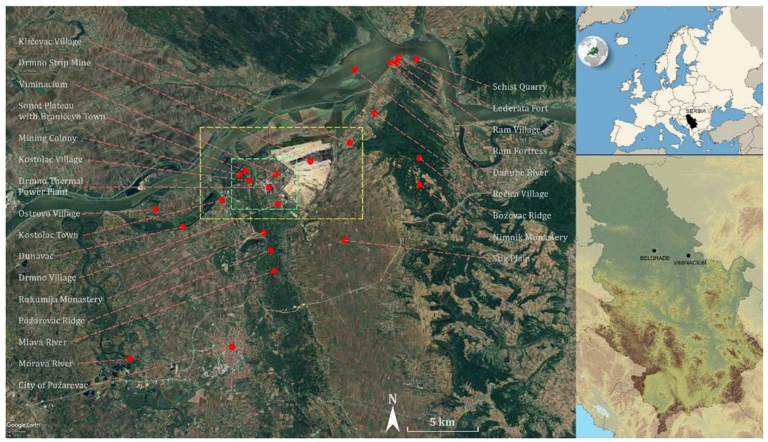
Figure 2.
Areas marked in yellow and green on Figure 1: Villages with rivers – top - yellow; and Viminacium Archaeological Park with near surroundings - bottom - green (Tags: Authors on Google Earth Pro 7.3.6.10441 (64-bit) photo printed on January 12, 2026; historical image from June, 2025; Image © 2025 Airbus).
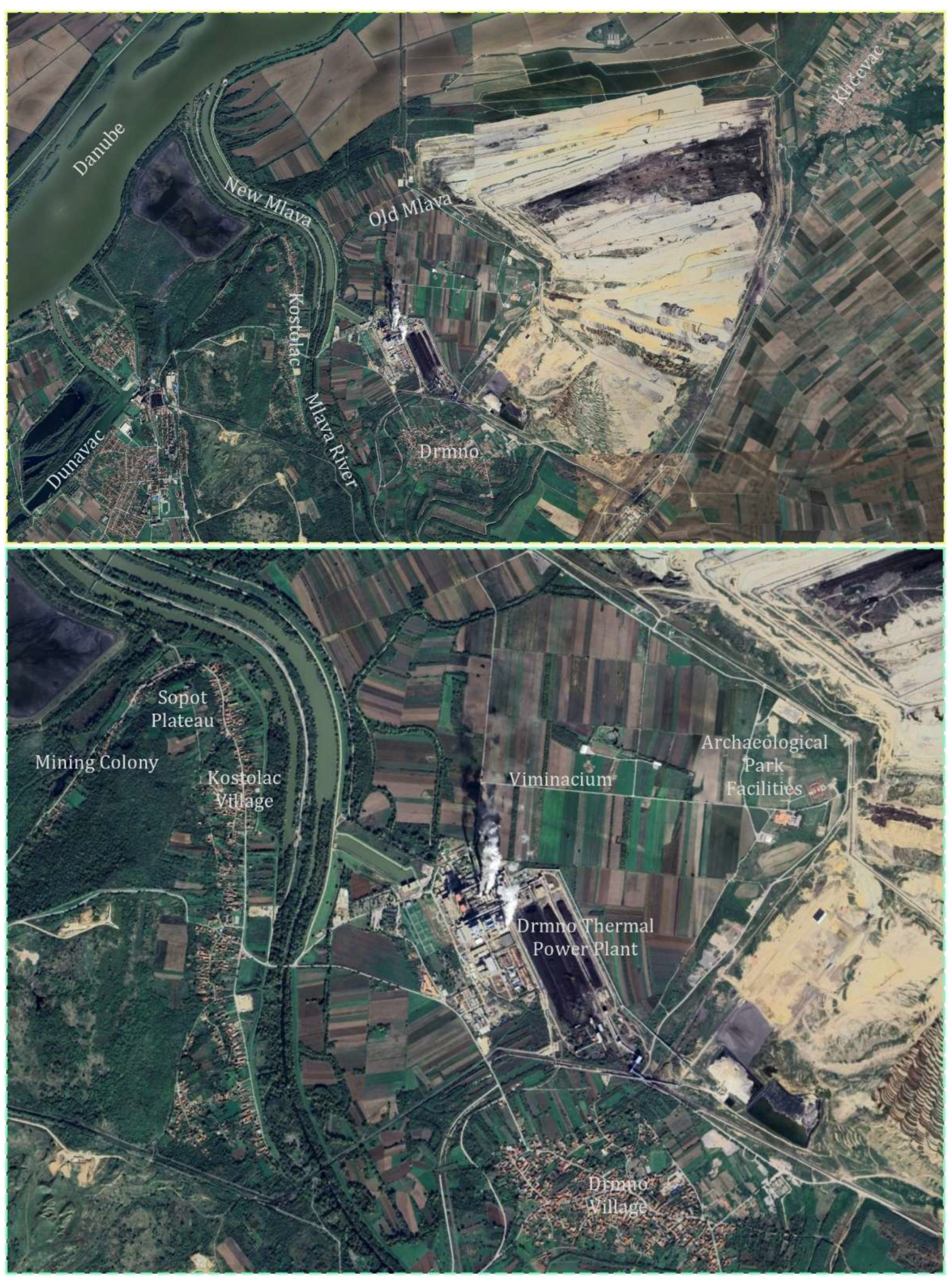
Figure 3.
Aerial views of the Roman city and fortress of Viminacium buried beneath Kostolac agricultural fields with excavated and protected archaeological remains and modern facilities, alongside the Drmno thermal power plant and strip mine (documentation of the Institute of Archaeology, Belgrade, Serbia, from 2015 – top; 2017 – centre; and 2022 - bottom).
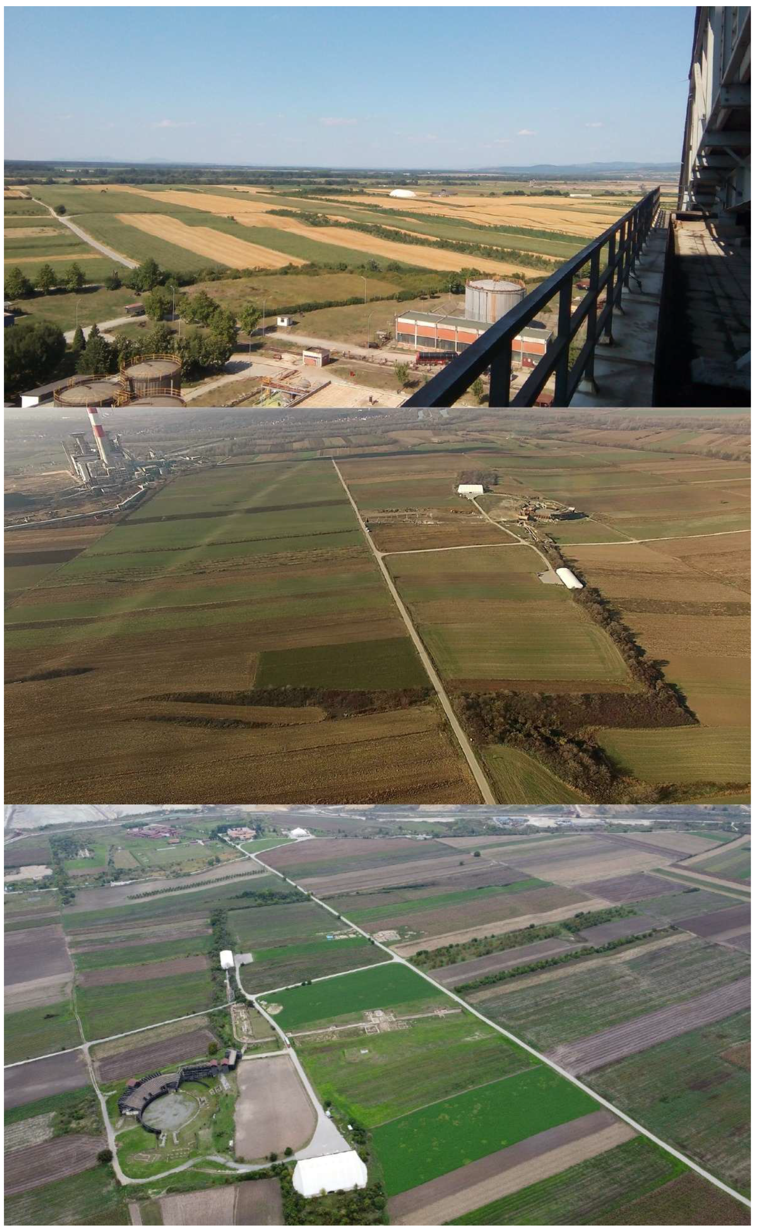
Figure 4.
View of the Stig Plain and Požarevac Ridge from the foothill of the Boževac Ridge (documentation of the Institute of Archaeology, Belgrade, Serbia, 2021).
Figure 4.
View of the Stig Plain and Požarevac Ridge from the foothill of the Boževac Ridge (documentation of the Institute of Archaeology, Belgrade, Serbia, 2021).
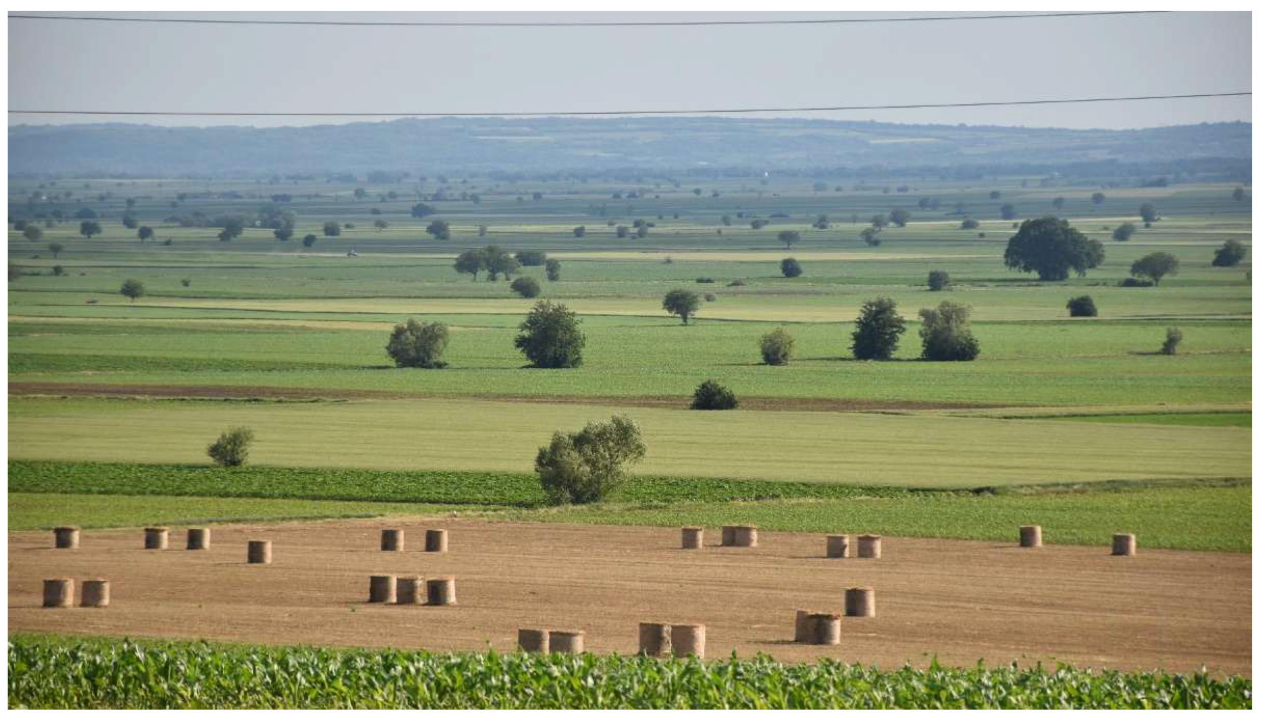
Figure 5.
Ram-Zatonje sands (documentation of the Institute of Archaeology, Belgrade, Serbia, 2021).
Figure 5.
Ram-Zatonje sands (documentation of the Institute of Archaeology, Belgrade, Serbia, 2021).
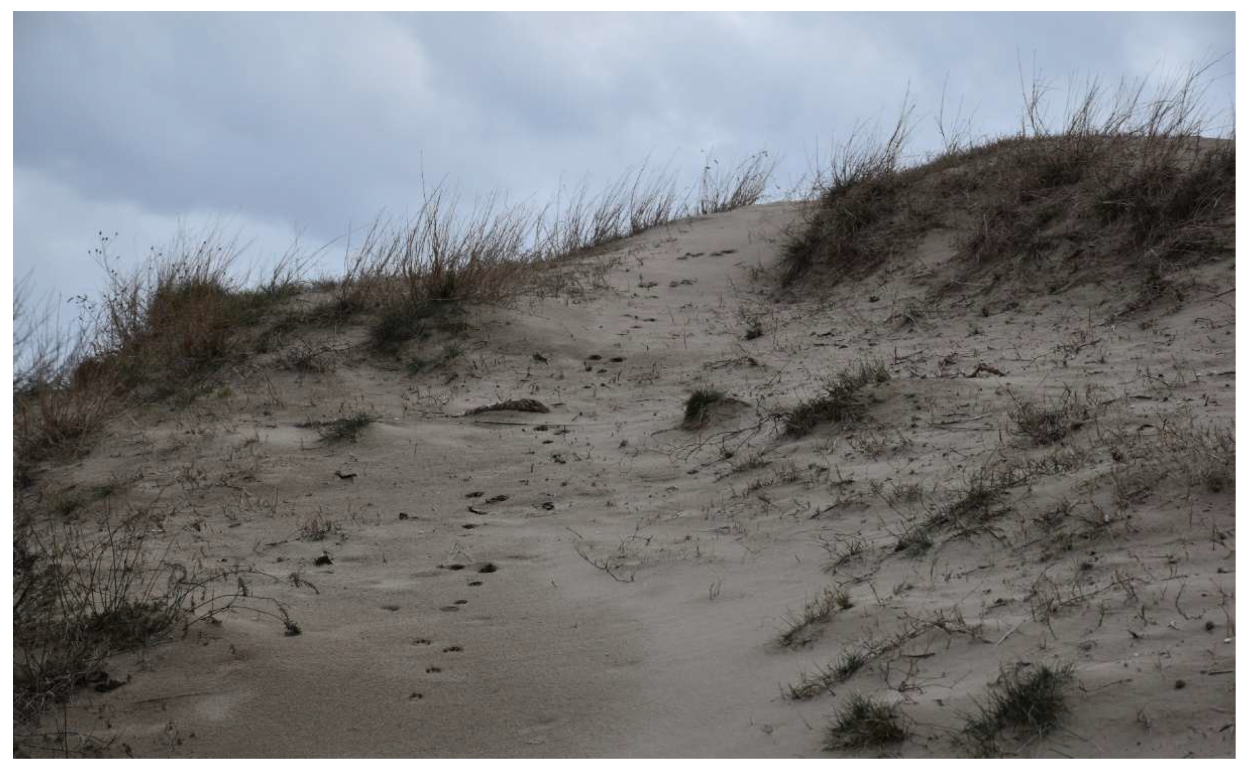
Figure 6.
Ram Fortress built of schist at the schistose outcrop – the edge of Boževac Ridge (documentation of the Institute of Archaeology, Belgrade, Serbia, 2021).
Figure 6.
Ram Fortress built of schist at the schistose outcrop – the edge of Boževac Ridge (documentation of the Institute of Archaeology, Belgrade, Serbia, 2021).
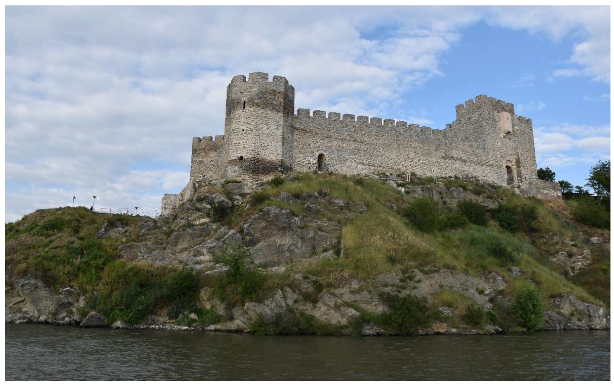
Figure 7.
Remains of a ceramic tile floor in one of the rooms of the principia at Viminacium (documentation of the Institute of Archaeology, Belgrade, Serbia, 2021).
Figure 7.
Remains of a ceramic tile floor in one of the rooms of the principia at Viminacium (documentation of the Institute of Archaeology, Belgrade, Serbia, 2021).
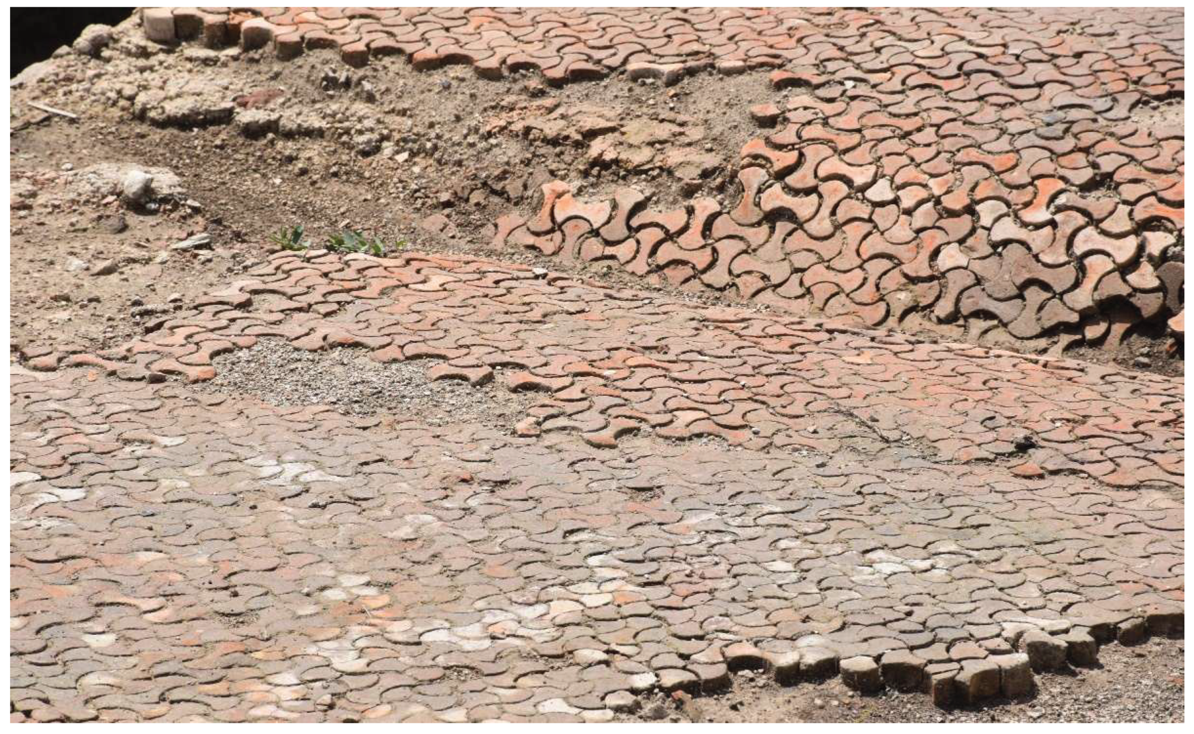
Figure 8.
Crvenka bed in the Sopot Ridge above the village of Kostolac (documentation of the MoDeCo2000 Project, 2021; [8] (p. 12) (© 2023 by the authors. Licensee MDPI, Basel, Switzerland / CC BY 4.0).
Figure 8.
Crvenka bed in the Sopot Ridge above the village of Kostolac (documentation of the MoDeCo2000 Project, 2021; [8] (p. 12) (© 2023 by the authors. Licensee MDPI, Basel, Switzerland / CC BY 4.0).
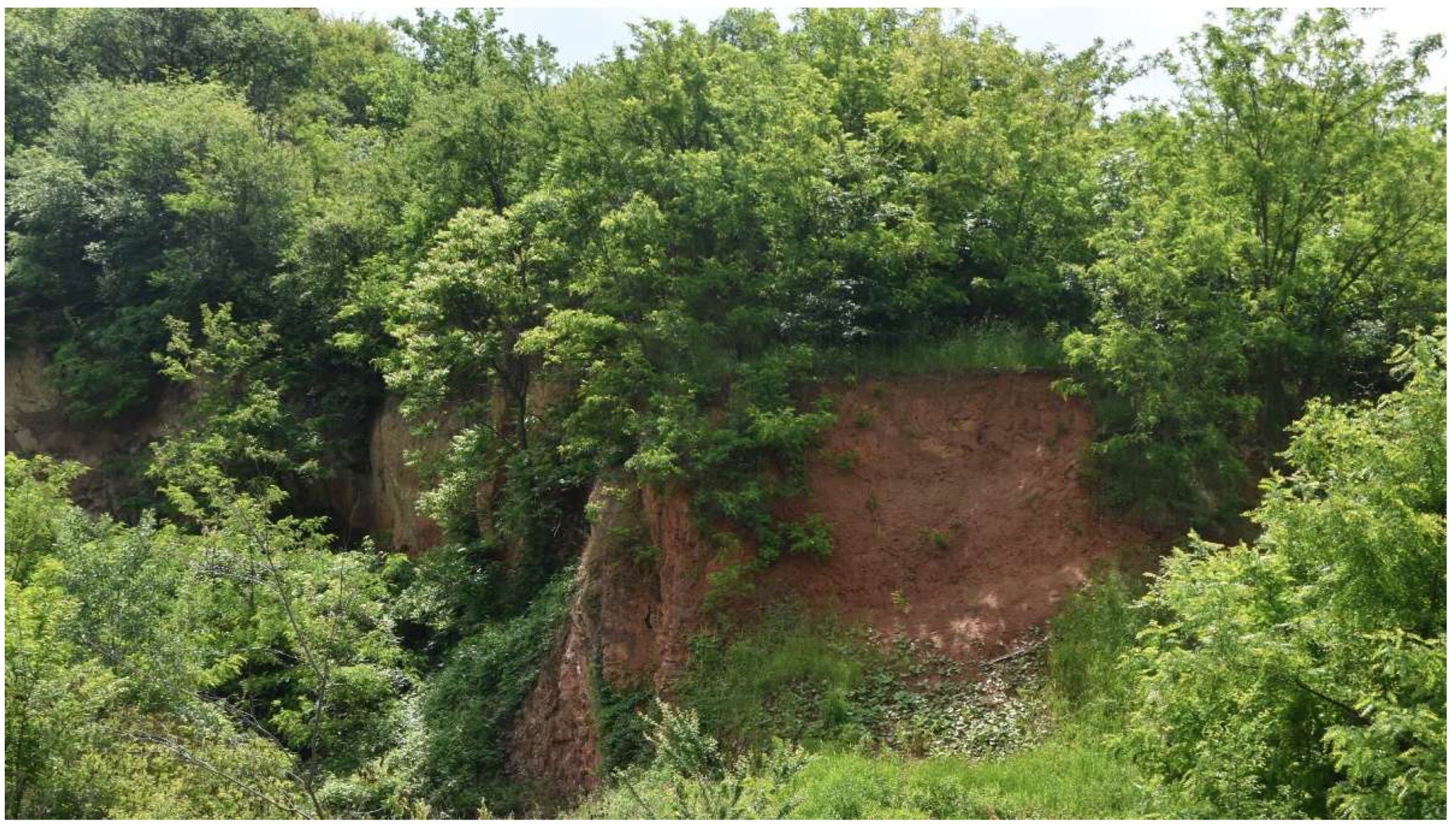
Figure 9.
Two construction phases of the Viminacium legionary fortress rampart, built of schist and crvenka, with associated architectural remains and the Drmno thermal power plant complex in the background (documentation of the Institute of Archaeology, Belgrade, Serbia, 2021).
Figure 9.
Two construction phases of the Viminacium legionary fortress rampart, built of schist and crvenka, with associated architectural remains and the Drmno thermal power plant complex in the background (documentation of the Institute of Archaeology, Belgrade, Serbia, 2021).
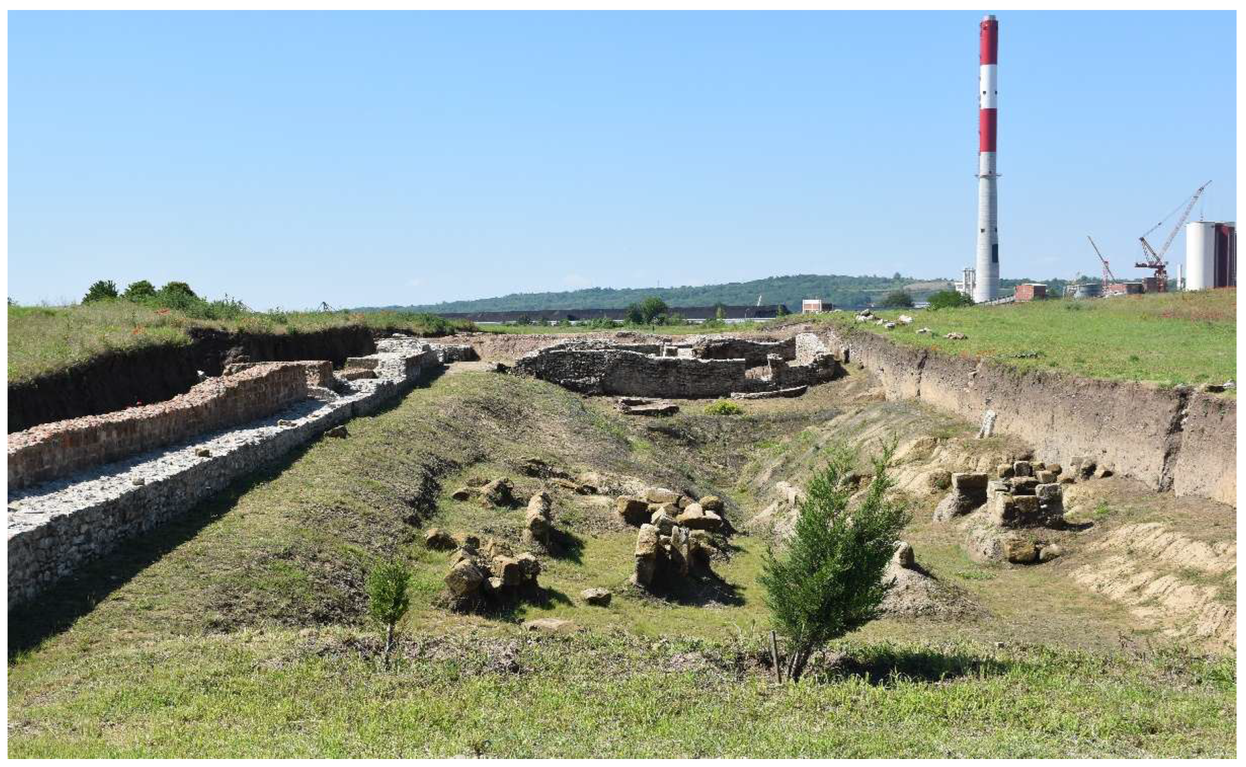
Figure 10.
Viminacium aerial views with marked sites discussed in this study: From 2005 - top (Tags: Authors on Google Earth Pro 7.3.6.10441 (64-bit) photo printed on January 12, 2026; historical image from January, 2005; Image © 2025 Maxar Technologies); From 2025 - bottom (Tags: Authors on Google Earth Pro 7.3.6.10441 (64-bit) photo printed on January 12, 2026; historical image from June, 2025; Image © 2025 Airbus); Wind rose on the top photo from the meteorological station in Veliko Gradište (© Meteoblue. Simulirani istorijski klimatski i meterološki podaci za Veliko Gradište / CC BY-NC 4.0, https://www.meteoblue.com/sr/vreme/historyclimate/climatemodelled/veliko-gradi%C5%A1te_%D0%A1%D1%80%D0%B1%D0%B8%D1%98%D0%B0_784535, accessed on January 12, 2026).
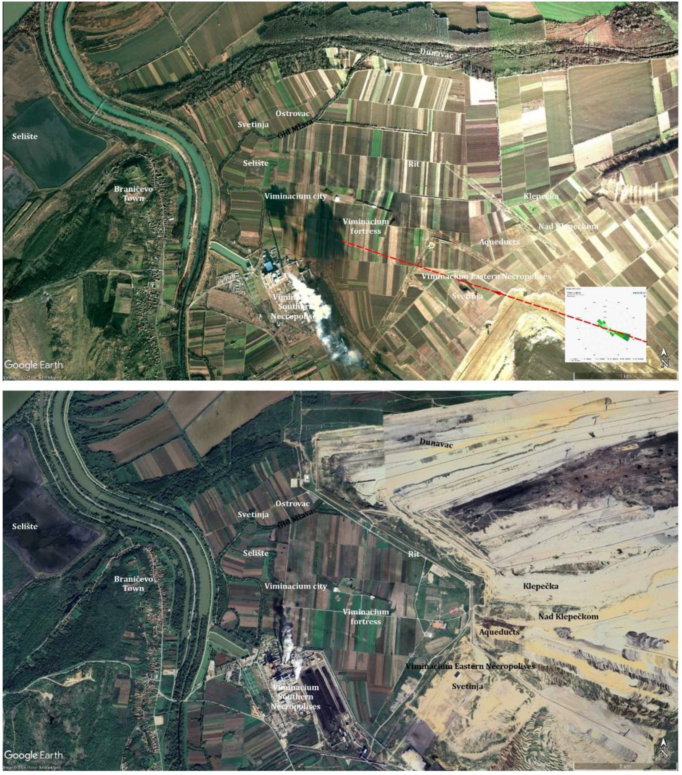
Figure 11.
Viminacium aqueducts during the excavations in 2003 (documentation of the Institute of Archaeology, Belgrade, Serbia).
Figure 11.
Viminacium aqueducts during the excavations in 2003 (documentation of the Institute of Archaeology, Belgrade, Serbia).
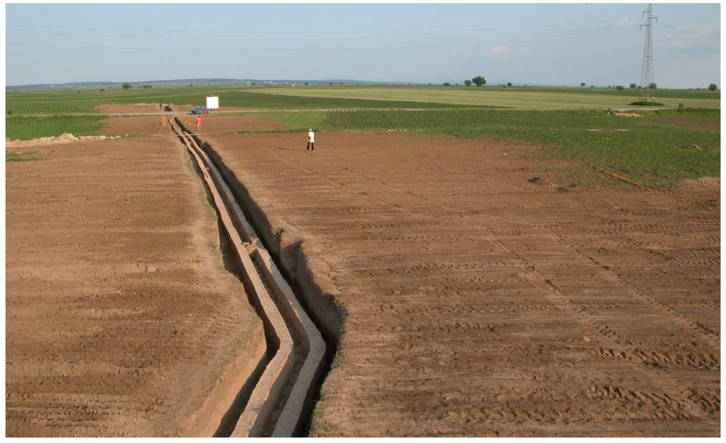
Figure 12.
Drainage channel (left) and a well (right) excavated in a Roman villa at the “Rit” site (documentation of the Institute of Archaeology, Belgrade, Serbia; [140] (p. 101; p. 104) (© 2018 Institute of Archaeology, Belgrade, Serbia / All rights reserved).
Figure 12.
Drainage channel (left) and a well (right) excavated in a Roman villa at the “Rit” site (documentation of the Institute of Archaeology, Belgrade, Serbia; [140] (p. 101; p. 104) (© 2018 Institute of Archaeology, Belgrade, Serbia / All rights reserved).
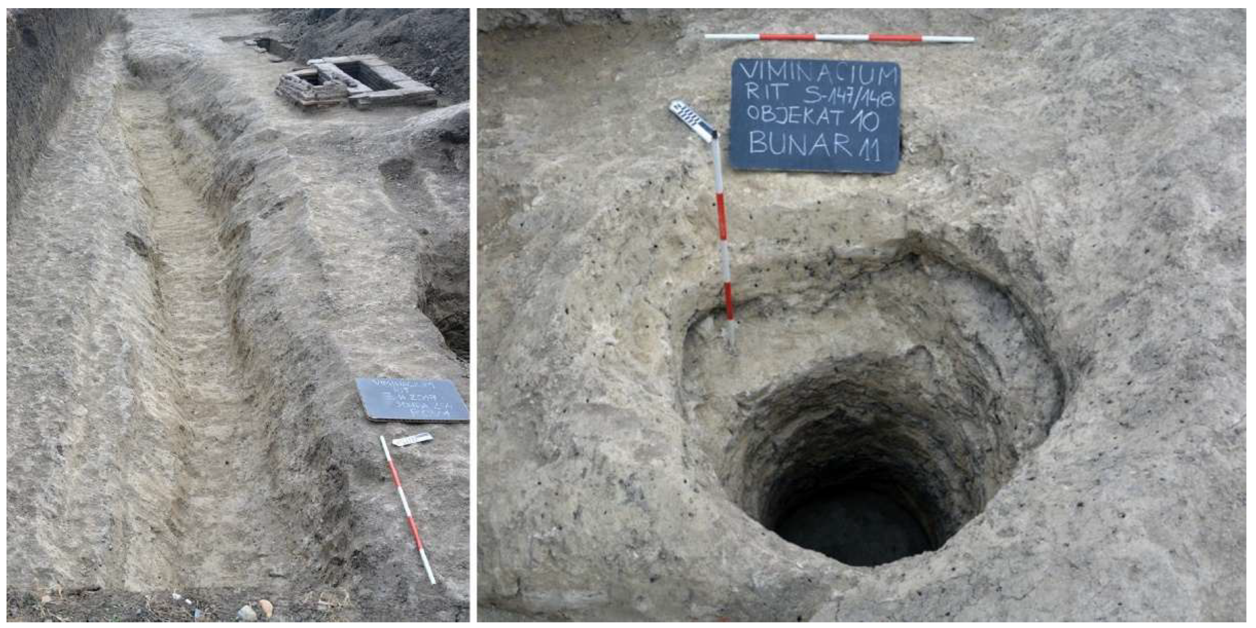
Figure 13.
Sopot Plateau with the buried remains of the Braničevo fort (documentation of the Institute of Archaeology, Belgrade, Serbia, 2021).
Figure 13.
Sopot Plateau with the buried remains of the Braničevo fort (documentation of the Institute of Archaeology, Belgrade, Serbia, 2021).
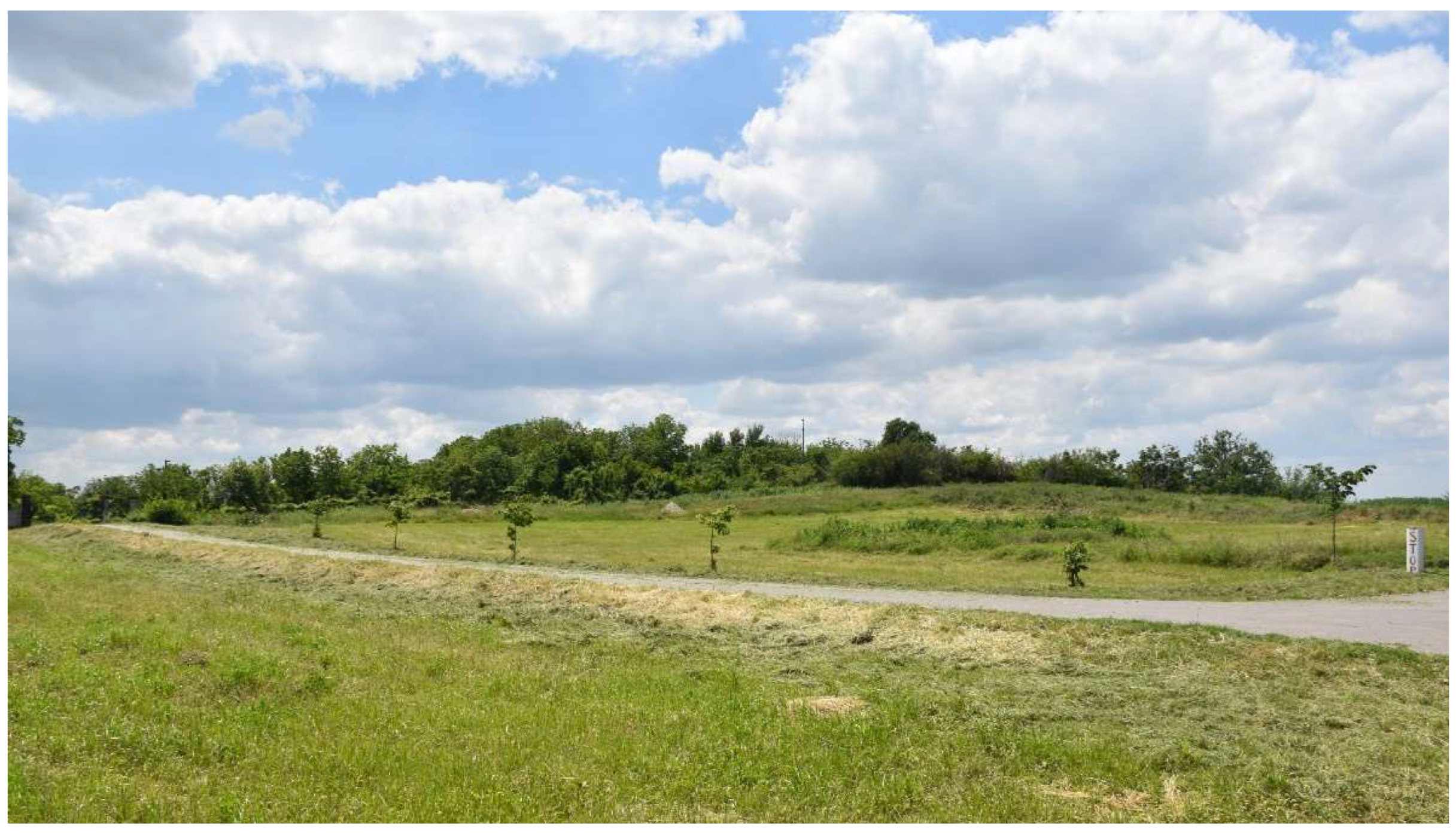
Figure 14.
Kostolac village (documentation of the Institute of Archaeology, Belgrade, Serbia, 2017): old houses and the mining colony (top); entrance to the old underground mine and the Church of St. George (top centre); modern houses and the village centre (bottom centre); the Mlava embankment and the cemetery within the thermal power plant complex (bottom).
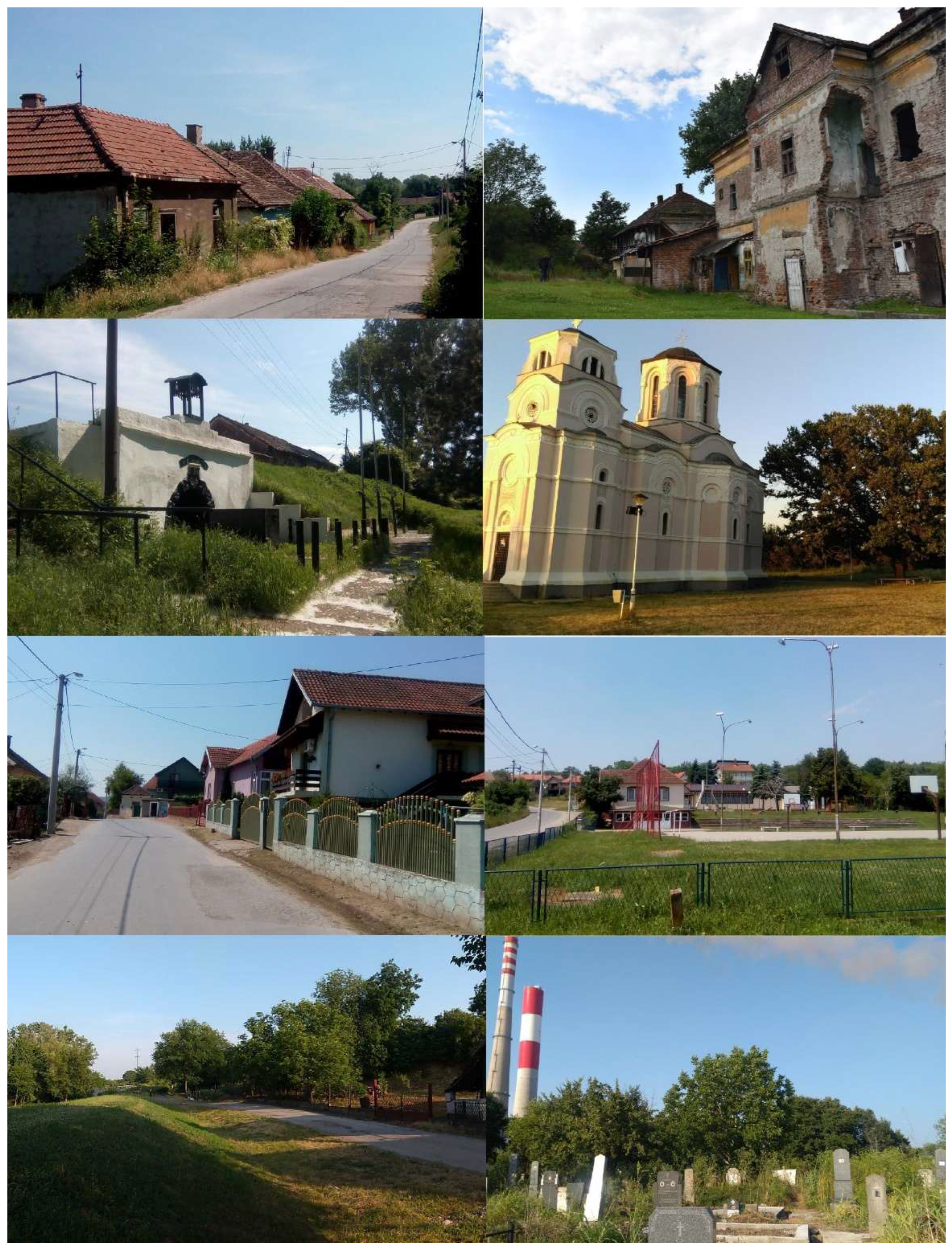
Figure 15.
Kostolac town (documentation of the Institute of Archaeology, Belgrade, Serbia, 2017-2018): Collective housing (top); A house in the German settlement (centre); town centre with the old mining locomotive in the park (bottom).
Figure 15.
Kostolac town (documentation of the Institute of Archaeology, Belgrade, Serbia, 2017-2018): Collective housing (top); A house in the German settlement (centre); town centre with the old mining locomotive in the park (bottom).
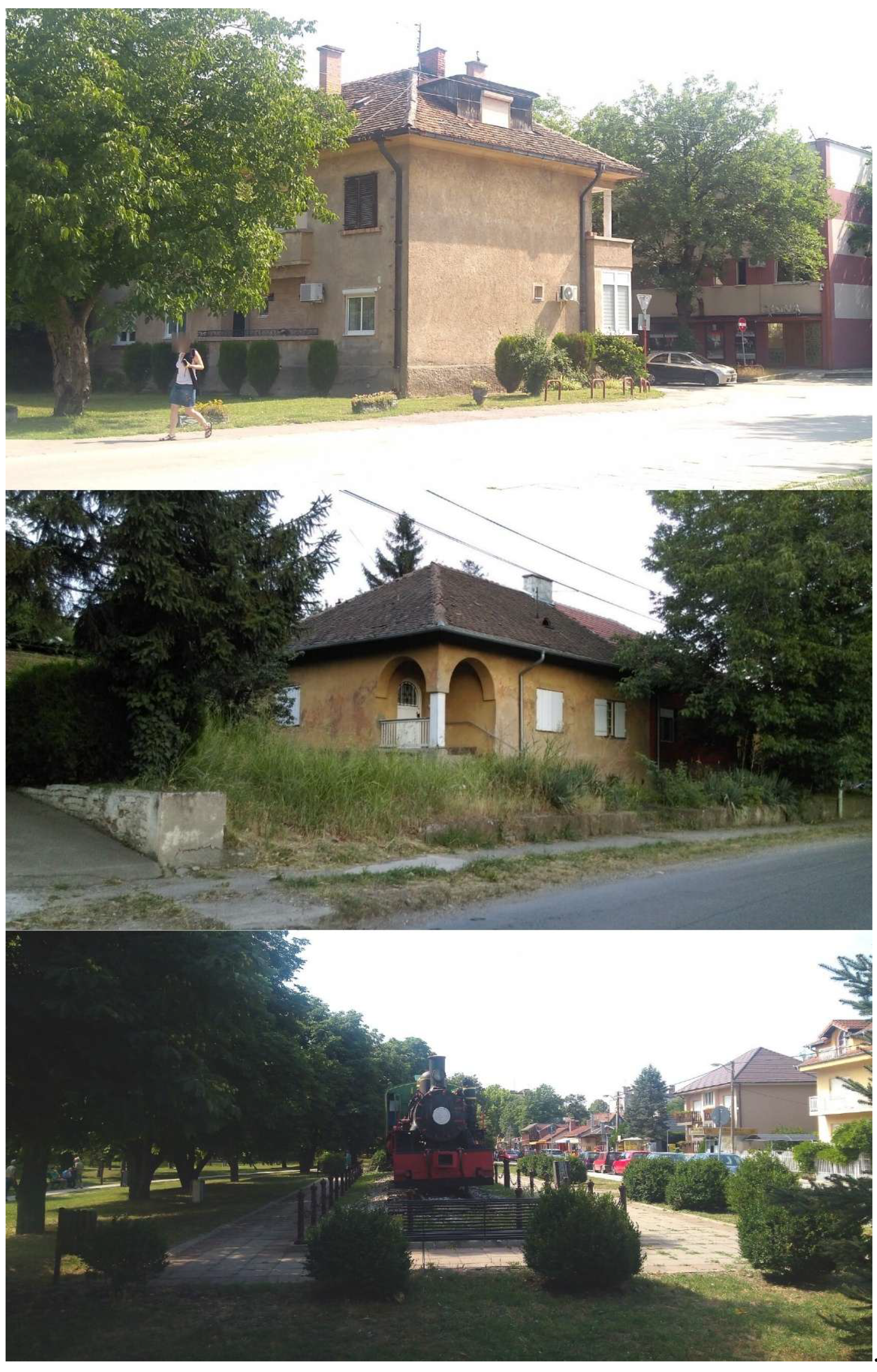
Figure 16.
City of Požarevac: Modern city centre in the 1980s (top) (© Vujcic / Wikimedia Commons / CC BY 2.0, https://commons.wikimedia.org/wiki/File:Streets_of_Po%C5%BEarevac.jpg, accessed on January 13, 2026); the main city administrative building (top centre), Prince Miloš Monument in the City Park (bottom centre), and a wealthy family house (later housing the National Museum with the major Viminacium collection, being the second-oldest museum in Serbia) (bottom), all erected at the end of the 19th century (documentation of the Institute of Archaeology, Belgrade, Serbia, 2017–2018).
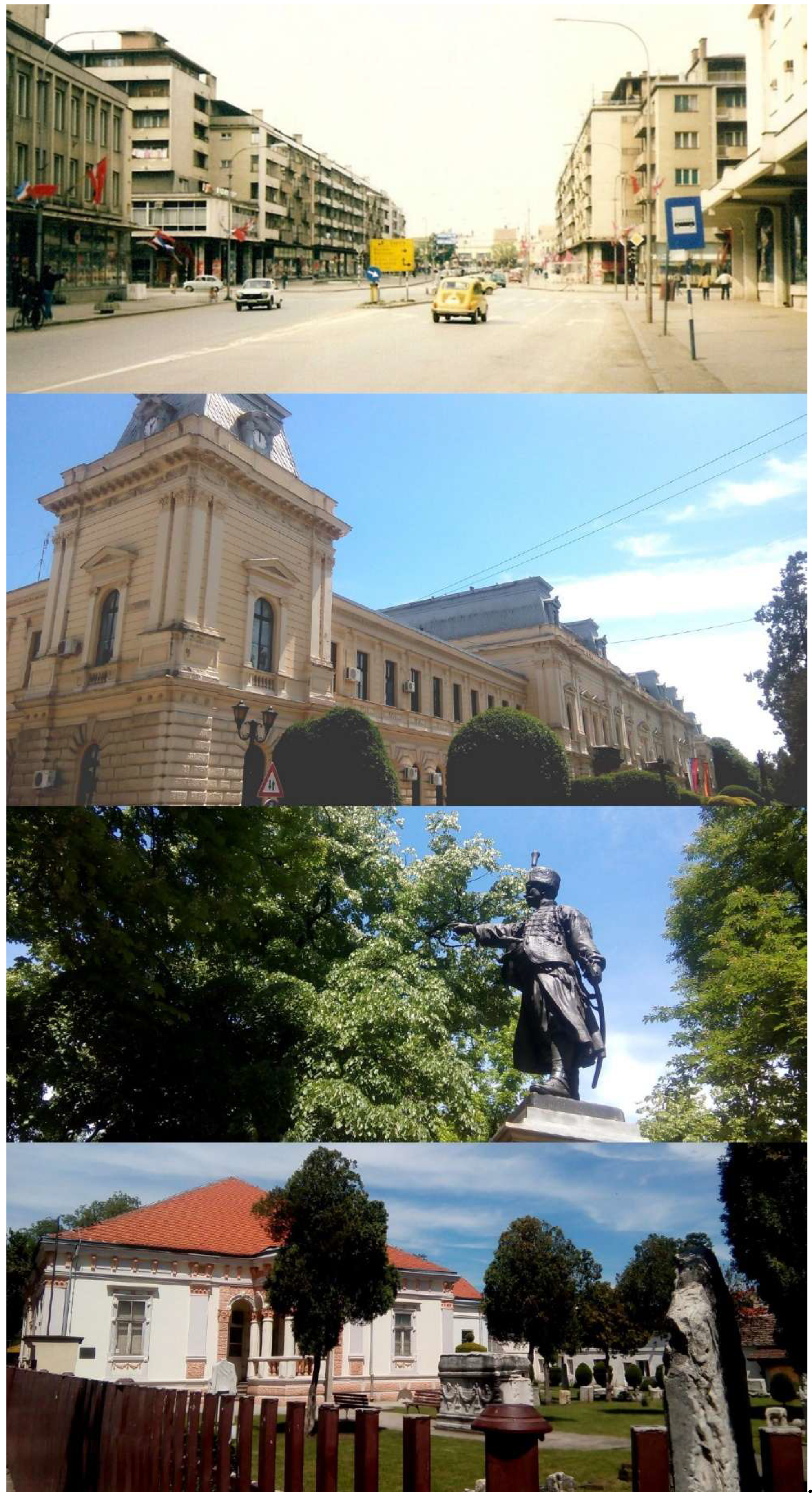
Figure 17.
View from the Ram Fortress toward the Danube and its now half-submerged small islands north of Viminacium (documentation of the Institute of Archaeology, Belgrade, Serbia, 2021).
Figure 17.
View from the Ram Fortress toward the Danube and its now half-submerged small islands north of Viminacium (documentation of the Institute of Archaeology, Belgrade, Serbia, 2021).
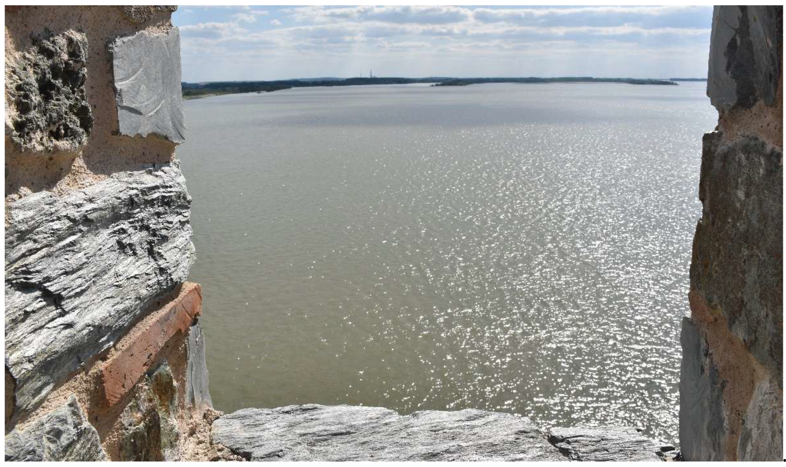
Figure 18.
Position of the Kostolac village in relation to the Mlava River: Austrian map, 1718 – left [214]; Carte der Scharmützel bei Rama, Kulisch, Hassan Pasa palanka und Ujpalanca, 1790 – centre [215]; A New Map of Turkey in Europe, 1794 – right [216].
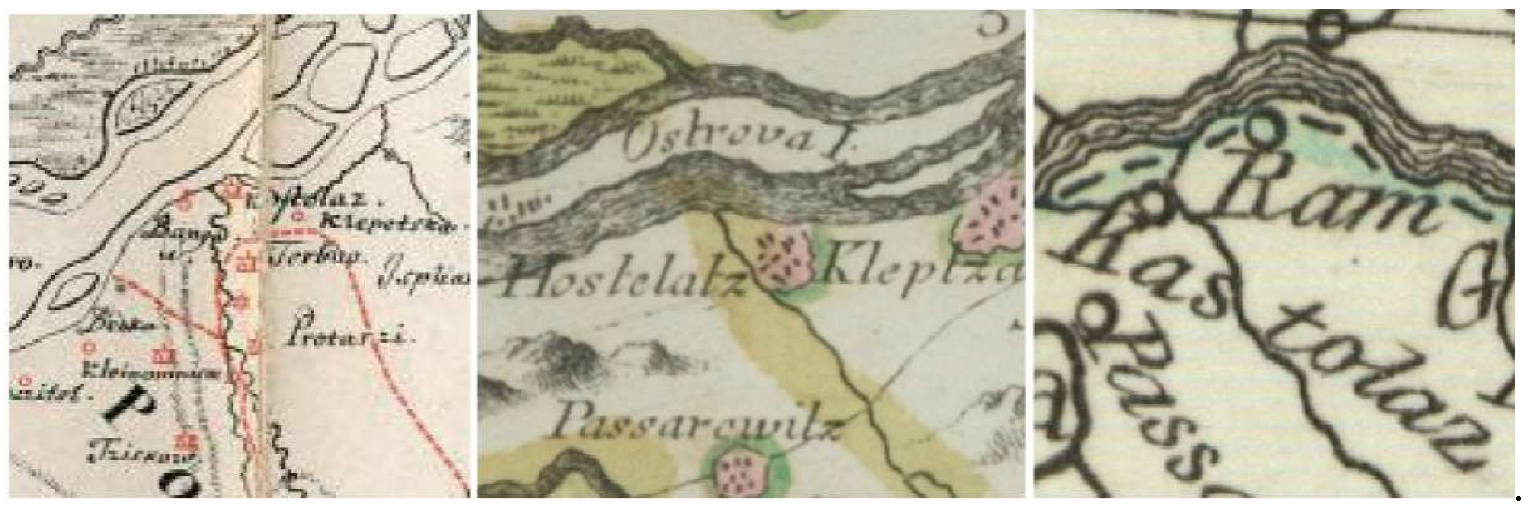
Figure 19.
Aerial view of the village of Kostolac from the Viminacium Archaeological Park: the Sopot Plateau with the church and the Danube in the background (left); the confluence of the Mlava and Danube rivers (right) (documentation of the Institute of Archaeology, Belgrade, Serbia, 2021).
Figure 19.
Aerial view of the village of Kostolac from the Viminacium Archaeological Park: the Sopot Plateau with the church and the Danube in the background (left); the confluence of the Mlava and Danube rivers (right) (documentation of the Institute of Archaeology, Belgrade, Serbia, 2021).
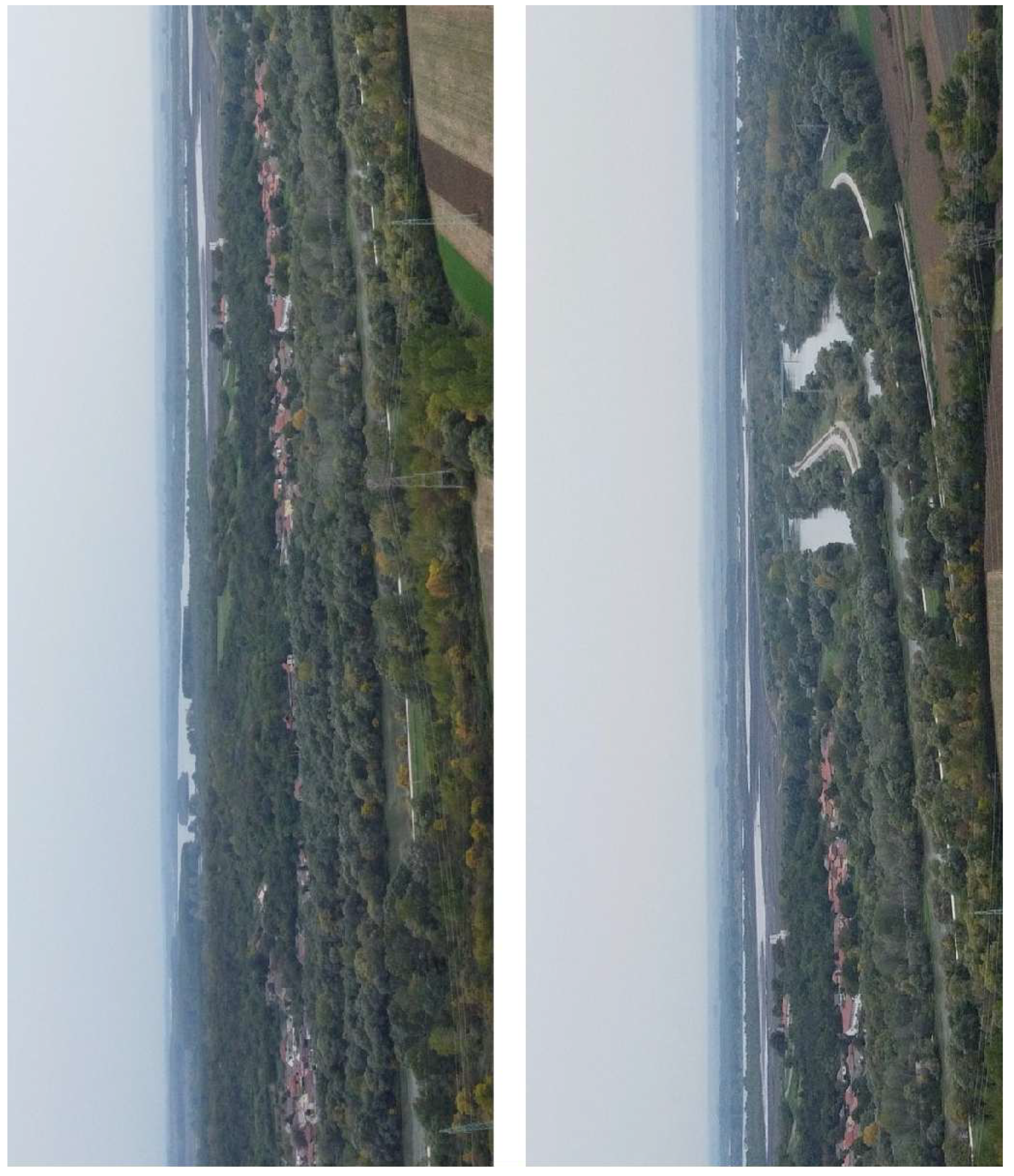
Figure 20.
Viminacium Archaeological Park – protected ancient remains and modern facilities at the edge of the strip mine, thermal power plant and the fields (documentation of the Institute of Archaeology, Belgrade, Serbia, 2021).
Figure 20.
Viminacium Archaeological Park – protected ancient remains and modern facilities at the edge of the strip mine, thermal power plant and the fields (documentation of the Institute of Archaeology, Belgrade, Serbia, 2021).
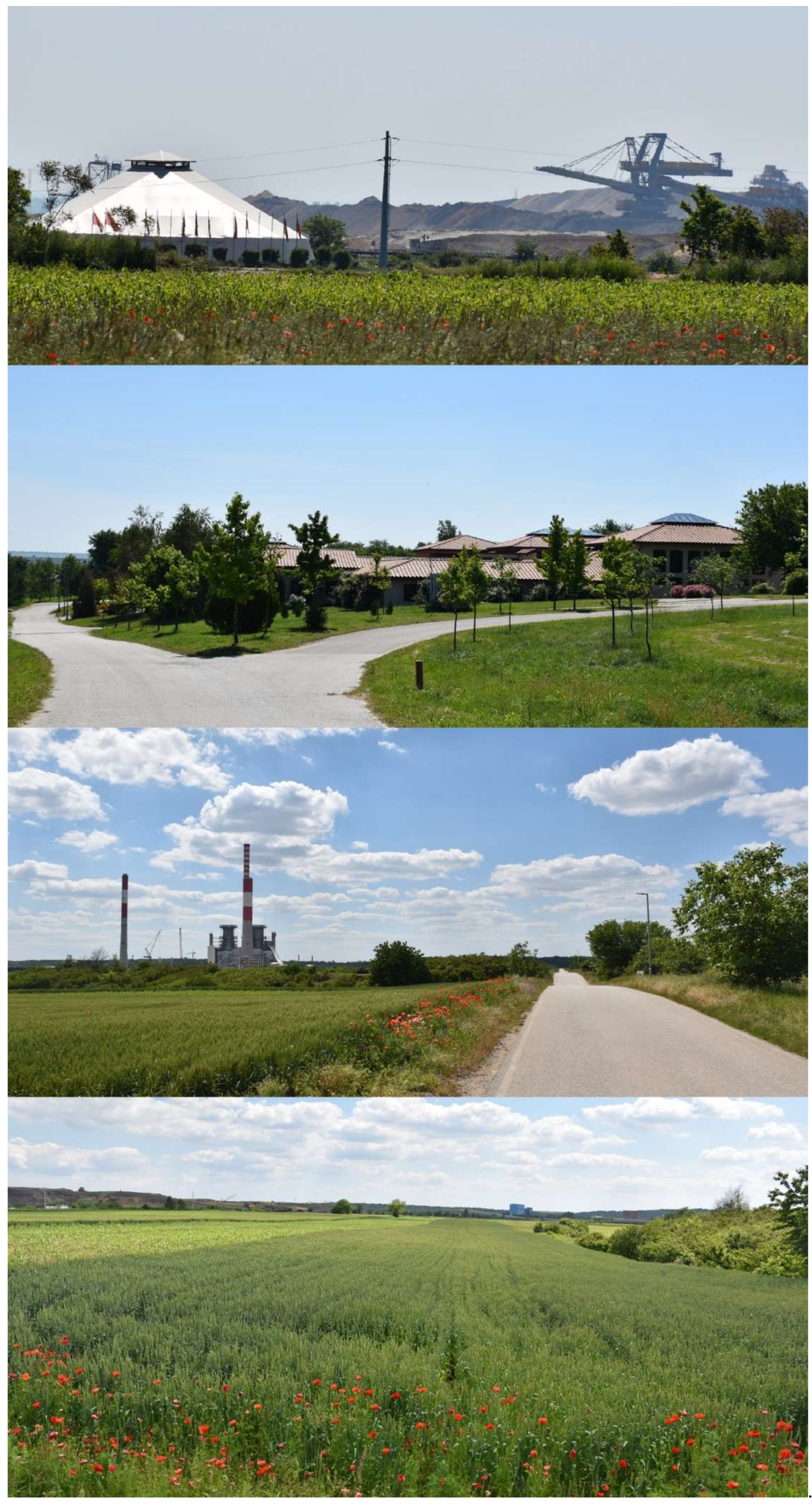
Disclaimer/Publisher’s Note: The statements, opinions and data contained in all publications are solely those of the individual author(s) and contributor(s) and not of MDPI and/or the editor(s). MDPI and/or the editor(s) disclaim responsibility for any injury to people or property resulting from any ideas, methods, instructions or products referred to in the content. |
© 2026 by the authors. Licensee MDPI, Basel, Switzerland. This article is an open access article distributed under the terms and conditions of the Creative Commons Attribution (CC BY) license (http://creativecommons.org/licenses/by/4.0/).
Copyright: This open access article is published under a Creative Commons CC BY 4.0 license, which permit the free download, distribution, and reuse, provided that the author and preprint are cited in any reuse.


