
Submitted:
20 November 2025
Posted:
20 November 2025
You are already at the latest version
Abstract
The Ambang River Basin holds significant significance for the residents of Greater Malang in East Java as they confront the peril of flooding. In order to assist the government in attaining the Sustainable Development Goals (SDGs), it is necessary for the management of the Ambang River Watershed (DAS) to incorporate ecological, economic, social, institutional, and technological aspects. The objective of this study is to assess the sustainability of the Ambang Sub-watershed and determine the key elements that impact the management's sustainability of the Ambang Sub-watershed. This study employs methodologies such as observation, interviews, documentation studies, and literature evaluation. The Malang rapflood tool employs a descriptive analytic technique and Multidimensional Scaling (MDS) for analysis. The results indicates that the sustainability of watershed management in the ecological, social, institutional, economic, and technological dimensions is classified as sustained for the upstream and middle Ambang sub- watersheds. The sustainability status of the Ambang sub-watershed management is classified as unsustainable. Improving the sustainable management of the Ambang sub-watershed requires attention to 21 variables.
Keywords:
rapflood MDS
; watershed sustainability
; limnology management
1. Introduction
Floods, droughts, land subsidence, and landslides are all water-related disasters that can impact people and their health [1,2,3]. Water, especially through floods, can be very destructive because natural and human processes interact in complex ways. For example, natural processes are things such as rainfall, landform, and sediment transport. Human activities are such as deforestation and urbanization [4,5]. If these natural mechanisms of erosion and deposition are ignored, they can impede the river in storing water.
When water, wind, and gravity remove soil and deposit it elsewhere, it is deposition [6]. The following factors influence this process precipitation, wind strength, surface runoff, soil type, land gradient, vegetation cover, and conservation measures. Intense precipitation, as an example, enhances surface runoff by detaching and transporting more soil particles, therefore accelerating soil loss. The sandy topsoil is also easily blown away by the wind, particularly in dry areas. But gravity causes rocks and soil to fall down hills, too [7]. There is going to be flooding if the above problems don’t improve.
During rainfall, higher precipitation amounts can accelerate surface water flow. This accelerates processes of erosion and sedimentation causing narrowing of river channels. When sediment lodges in a river and obstructs water flow, it leads to floods. Flooding is a common occurrence when rain is heavy and the runoff flowing over the land surface is more than the river can accommodate. This is exacerbated by the accumulation of sediment in the channel, which reduces its width [8,9]. Prevention measures include biophysical, socio-institutional, and economic interventions aiming at decreasing susceptibility to these disasters [10,11]. A watershed (DAS) is an area where the rain falls and runs off into rivers, lakes, or reservoirs that ultimately lead to the ocean. Watersheds are ecosystems that connect people with nature. Alterations in a single portion of a watershed influence the entire system [12]. In this sense, effective watershed management is crucial to promote fish and wildlife good watershed management is very important in this respect to preserve healthy ecosystems and prevent natural disasters, such as floods.
A watershed is made up of three sections: the upper, mid, and lower sections of a river [13,14]. Headwaters are the source of streams In a watershed, the upper watershed’s ecosystems are instrumental in maintaining the health of the entire watershed Treatmann’s research shows that the Biodiversity and Ecosystem Services of this region can enable it to be more resistant to environmental change and facilitate water flow in ways that benefit downstream areas; for example, as buffers against flooding [15].
The Ambang Sub-Watershed is easily flooded in Malang Raya area. The three administrative regions that form part of it include Batu City (upstream), Malang City (middle) and Malang Regency (downstream). The elevation range in the Ambang Sub-Watershed is the lowest, between 305 m.a.s.l. Onze jarenlange kennis van stroomgebieden waters drehen de peuter van de wereld in Pakijs alweer om? 2 November, the following happened: a flash flood occurred in the villages of Sumber Brantas and Bulukerto, in Batu City, East Java. This flash flood, which destroyed homes and displaced people, also claimed lives. The flood was triggered by heavy rain and landslides that occurred at the upper slopes of the river valley. These can really advocate us why letting watersheds be safe from stuff failures, such as this incident, matters. This study is intended to evaluate the sustainability of Ambang Watershed management in terms of ecological, social, economic, institutional, and technological aspects.
Watershed management has been talked about plenty in Indonesia before especially collaborating with people from other fields and having them work together. However, these two aspects have not been integrated in any particular framework for watershed management [16]. The study reveals gaps in prior research namely, disconnect between sectors and regions, and insufficient participation by the community. As a result, this research is concerned with the application of Multidimensional Scaling (MDS) in evaluating the sustainability of Ambang Watershed management in a holistic sense and in identifying the determinants of this sustaining in a multidimensional framework.
From an institutional point of view, natural resource management at the watershed level requires balancing the competing interests of various stakeholders [17]. In order to achieve effective watershed management, coordination among holders of land-use rights, landholders, and government agencies needs to be enhanced. This research indicates that the overall performance of watershed management is determined by numerous influential individuals with strong interests and high authority in the process [18]. The resources and the influence an institution can leverage are dependent on its purpose and function. And so it means that in order to accomplish their goals, the government agencies that oversee the watersheds have to consider what the people want and how they can assist.
The following are key provisions of Government Regulations 37/2012 concerning watershed management in Indonesia: Firstly, is it all part of watershed managementa comprehensive effort of watershed management planning implementation community monitoring evaluation and education and regulation [19,20]. Secondly, effective and integrated watershed management is undertaken in conjunction with spatial planning and water resources management [16]. Finally, “there is a lot of work that is being done to coordinate more between agencies, sectors, levels of government in the region with community support” [17]. People at different levels of government work collectively to manage watersheds, and each one has its own role and responsibility [21]. It is difficult for governance to synchronize management, flow and stakeholder participation when watersheds and political borders are not linear [22].
All people play a role in IWM, which is the process of managing the watershed. It enables superior coordination between all actors, in a way that benefits everyone, from the upper stream to the lower stream [23]. However, IWM is plagued with multiple problems such as poor interregional and intersectoral cooperation, insufficient community participation, multiple, and overlapping regulations and management jurisdictions and uneven information among those working on watershed management [16]. As a result, the watershed has not improved sufficiently. But on the long side of things, climate change is damaging to watersheds, too. So, Indonesia has the opportunity to enhance the IWM for climate change mitigation and adaptation by adopting a transformative path. This implies that coordination, participation and collaboration [24] should be prioritized as well as ensuring transparency and accountability in the execution phase [25], that roles are clearly defined, and that mechanisms for sustainable funding from multiple sources are established [26].
The ideas of coordination, participation, and collaboration related to watershed management in Indonesia even date back to the 1980s and 1990s. Yet these principles have not been put into practice effectively [27]. This is because each stakeholder has their own vested interests and does not care about the project, and there are no regulations that bind them to employ the Integrated Watershed Management (IWM) methodology [28]. Comprehensive legal system like the law, the government regulation, or the regional order is vital in making the watershed management plan incorporated into the regional spatial planning [29].
In watershed management, the influence of upstream-to-downstream areas is crucial for the implementation of SWC measures [30]. Full water management and disaster reduction program at the upstream area might be a solution for water scarcity at the downstream areas [31,32]. Early downstream watershed management, especially in metropolitan areas, was primarily concerned with disaster mitigations from floods, flash floods, droughts, and environmental degradation [33]. This approach has been abandoned in favour of full From Problem Solving to IWRM: Implications for Water Management in Upstream−Downstream relations thinking since it deals exclusively with problems rather than the causes of major problems in upstream areas. The IWRM approach provides a strategy for building on the downstream watershed management activities [34,35]. Integrated Water Resources Management (IWRM) is the conceptual framework within which hydrometeorological disaster mitigation is pursued. It starts at the top and works its way down.
Also, the IWRM approach can be applied to the management of climate change impact and natural disasters such as floods and droughts [36,37]. To control the flood in the downstream area, the first priority is to control them in the watershed area at the upstream by implementing Soil and Water Conservation (SWC) measures. This is done to reduce the risk of runoff, which could result in flooding down the road. Cities and downstream areas are also hustling to retrofit infrastructure to make flood damage less severe. This involves digging biopores, ponds to store water, and wells to receive water. The main purpose of these water conservation structures is to increase groundwater recharge and reduce surface runoff [38]. The technical integration results from the harmonization of two-scale environmental focus: vegetative cover on watersheds scales under the ideas of natural restoration and adaptive civil engineering structures on hillslopes under the aspect of soil/water conservation (SWC) as a response to climate event [17].
The National Disaster Management Authority of Indonesia The agency revealed that the most frequent and deadliest disaster of floods has been oscillating increasingly after steady and significant rises in the last 200 years, especially since the country entered the new century [39]. This study is natural to limit flood vulnerability and increase the realization of Sustainable Development Goals (SDGs), specifically those concerning clean water and sanitation management (SDG 6), climate action (SDG 13), and terrestrial ecosystems (SDG 15). Good Watershed management is critical to protecting the environment, community health, and mitigating disasters. This study was focused on the sustainability of Ambang Watershed management based on flood disaster vulnerability and to provide policy implications for improving runoff-based flood disaster resilience of the watershed.
This study is aimed to analyze the status of sustainable management of Ambang Watershed based on its flood vulnerability in Malang City. The questions addressed in this study are: How sustainable is Ambang Watershed management in the ecological, economic, social, institutional, and technological aspects? What are the driving forces of Ambang Watershed management in its sustainability to flood? This study investigates to present novel findings for improved and sustainable watersheds management in Ambang through a complete analytical framework and utilizing Multidimensional Scaling (MDS) Method, at the same time, as a benchmark to formulate| better policies in handling water related disaster in Indonesia.
2. Material and Method
The research was conducted in Greter Malang District, East Java, Indonesia, from August 2022 to November 2023. This study is a, in addition to write p itself researcher carried on researching on papers before performing research. The idea of ‘index evaluation, which is applied to evaluate the situation of sustainable development, has broadened to five aspects: ecological, economic, social, institutional and technological [40].
This study separates the Ambang Sub-watershed area into three zones:
a. Batu City area belongs to the Upper Sub-Watershed,
b. The Area of Malang City belongs to the Middle Sub-Watershed.
c. The Malang District is a part of Hilir sub-watershed.
The division was motivated by the distinctive characteristics of each sub-watershed region and its population, as well as opinions expressed in conversations with experts. The concept of index measurement to assess the state of sustainable development has been extended to cover five dimensions: ecological, economic, social, institutional, and technological [40]. The attribute data that has been collected represents five sustainability facets for the Ambang watershed to include ecological, social, institutional and technological. 3.4 Data collection Expert interviews and literature reviews related information on the characteristics of each attribute within each dimension. What constitutes original data are a) the institutional data, collected at the local level, c) the information on the conditions of land cover, and d) the use of technology, specifically farming’s in the way of conservation. This information is the result of interviews with a wide range of stakeholders, including community leaders, farmer associations, non governmental extension agents and government officials, regional government representatives, academics, researchers, and experts. This data is also collected by conducting field work.
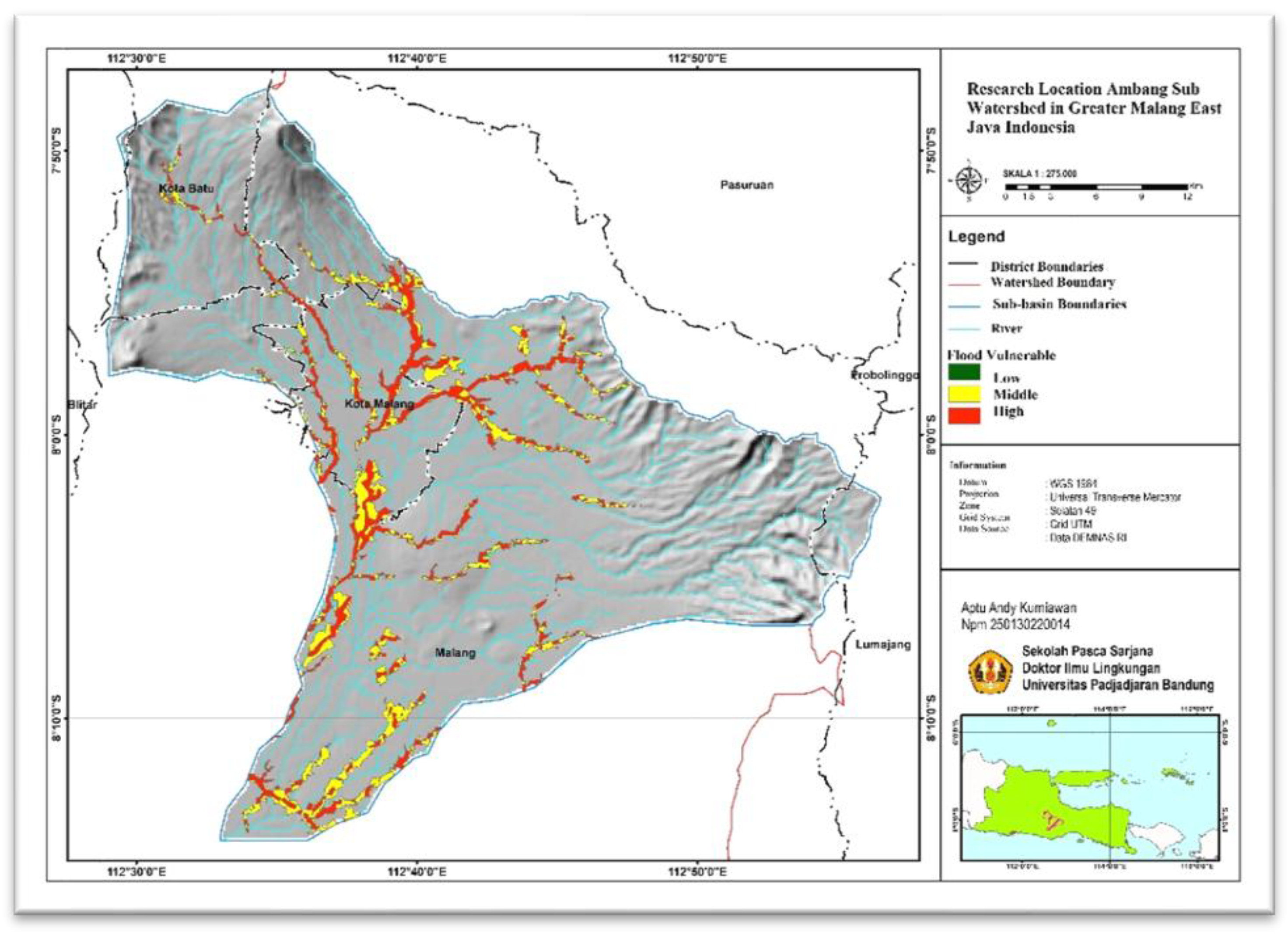
Figure 1.
The study area in Greater Malang, East Java, Indonesia.
Data collection was carried out by a number of methods, including participant observation, in-depth and structured interviews, document analysis, and review of the literature. The informants were from the central government, the regional government and community leaders, academicians, non-government counselors, environmentalists, and the community. We selected the expert respondents through purposive sampling based on their experience, knowledge and expertise regarding the Ambang Sub-watershed. Secondary data refers to ecological, economic, and social institutional (which includes rules and organizations), and other relevant information.
3. Results
The level of sustainability of Ambang Sub-watershed management was measured using indicators gathered from literature investigations, interviews, and discussions with expert respondents for each facet of sustainable development. There are a total of 8 indicators in each of the ecological, economic, social, institutional, and technological dimensions. Further analysis is required to determine the key characteristics that have the greatest impact on the sustainability of Ambang Sub-watershed management. These factors are known as indicators and need closer examination.

Table 1.
Categorization of the Sustainability Status of Sub watershed Ambang.
| No | Indeks Value | Category |
|---|---|---|
|
1 2 3 4 |
Not Sustainable Less Sustainable Sustained Highly sustainable |
0-25 26 > index value ≤ 50 51 > index value ≤ 75 76 > index value ≤100 |
Source: Kavanagh, 2001.
Ecological Dimension
The ecological dimension was assessed based on the findings of the literature review, interviews, and discussions with expert respondents. Eight indicators were identified: rainfall, land criticality, flood events, landslides, expansion of perennial plantation areas, maintenance of water sources, conversion of land to built-up land, and area planning for settlements.
The ecological dimension of sustainable management in the Ambang River Watershed Sub-District has a value of 53.18 in the upstream area, 63.33 in the middle part, and 54.02 in the downstream area (Figure 2). The three regions are classified as fairly sustainable.
According to the leverage analysis, the sustainability index value of the Ambang sub-watershed management in the ecological dimension is influenced by three leverage attributes: the possibility for landslides, land cover, and the availability of clean water sources (Figure 3).
4. Discussion
The findings of a preliminary investigation on the correlation between the systems approach to sustainability and the 17 sustainable development goals (SDGs) indicate that this approach defines sustainable development as a convergence of objectives connected to various interconnected systems, specifically environmental (ecological), economic, social, institutional, and technological systems [41]. Research findings of this nature can assist in formulating suitable policy responses to effectively accomplish targeted Sustainable Development Goals (SDGs) [42]. This approach requires cross-disciplinary collaboration, where stakeholders come together to formulate problems and solutions [43]. Cooperation by understanding how systems interact with each other will make policymakers able to design solutions that are more targeted [44,45]. By adopting a more holistic perspective, stakeholders will be able to manage sustainable development challenges more effectively, resulting in more innovative and impactful solutions [46].
In addition to biophysical issues, watershed problems arise as a consequence of disruptions in biophysical, economic, social, political, and institutional aspects [47]. Similar to the results for each dimension mentioned before, a total of 5 parameters were determined to be the most influential levers affecting the value of the multidimensional sustainability index for Mandar watershed management (Table 2). The results of the Monte Carlo analysis and MDS analysis, conducted at a confidence level of 95%, suggest that the discrepancy in value between the two analyses is negligible, or less than 1 (Table 3).
This indicates that the MDS analysis methodology employed is “sufficient” for assessing the sustainability level of the Ambang sub-watershed management. The Monte Carlo method can assess the impact of random mistakes on a process and provide an estimation of the actual value of the statistic being studied [48,49]. Table 3 displays the validation estimation outcomes for the five dimensions that exhibit a significant amount of validity, ranging from 0.06% to 0.93%. These results are classified as valid. The analysis output can be deemed a reliable estimating model. The mean sustainability index value for the management of the Ambang sub-watershed is 56.905, indicating consistent performance. This necessitates the requirement for earnest endeavors from all parties or stakeholders in facilitating the administration of the Ambang Sub-watershed.
The results of the multidimensional sustainability analysis of the management of the Ambang sub-watershed indicate that the index values for the upstream, middle, and downstream areas of the Ambang sub-watershed varied across the five dimensions, as shown in Table 3. Enhancing the sustainability of Ambang Sub-Watershed management can be achieved by intervening in Table 2 (21 factors) [29,50,51].
5. Conclusions
Status of sustainability of watershed management on ecological dimension, watershed management included in sustained category. In multidimensional terms, the status of watershed management Ambang is currently at sufficient status sustainable. There are 5 factors at most influence on sustainability management of the Ambang watershed. Improved sustainability status Ambang watershed management can be carried out including through policy interventions and implementation of relevant programs with the 5 most influential factors in sustainable management of the Ambang watershed.
Acknowledgments
The authors are grateful to the National Research Agency (BRIN Indonesia, This research is a component of a dissertation proposed as part of Padjadjaran University’s doctoral degree requirements.
Author Contributions
AAK: Conceptualization, Methodology, Software, Investigation, Formal analysis, Funding, Writing—Original Draft; S, H, IR: Conceptualization, Methodology, Resources, Supervision; Validation, Writing—Review and Editing.
Funding
The work was supported by National Research and Innovation Agency (BRIN) Indonesia.
Disclosure Statement
No potential conflict of interest was reported by the author(s).
References
- K. Lamichhane et al., “Unraveling the Causes and Impacts of Increasing Flood Disasters in the Kathmandu Valley: Lessons from the Unprecedented September 2024 Floods,” Natural Hazards Research, Apr. 2025. [CrossRef]
- J. Lee, D. Perera, T. Glickman, and L. Taing, “Water-related disasters and their health impacts: A global review,” Dec. 01, 2020, Elsevier Ltd. [CrossRef]
- M. Pizzorni, A. Innocenti, and N. Tollin, “Droughts and floods in a changing climate and implications for multi-hazard urban planning: A review,” Dec. 01, 2024, Elsevier B.V. [CrossRef]
- T. G. Andualem, G. A. Hewa, B. R. Myers, S. Peters, and J. Boland, “Erosion and Sediment Transport Modeling: A Systematic Review,” Jul. 01, 2023, Multidisciplinary Digital Publishing Institute (MDPI). [CrossRef]
- D. Bertoni, A. Pozzebon, P. Ruol, and C. Favaretto, “Tumbling Experiment for The Estimation of Abrasion and Mass Loss of Coastal Sediments from an Artificial Coarse-Clastic Beach,” Coastal Engineering Proceedings, 2023, pp. 59–61. [CrossRef]
- A. Firoozi and A. A. Firoozi, “Water erosion processes: Mechanisms, impact, and management strategies,” Results in Engineering, vol. 24, Dec. 2024. [CrossRef]
- Åhlén, J. Thorslund, P. Hambäck, G. Destouni, and J. Jarsjö, “Wetland position in the landscape: Impact on water storage and flood buffering,” Ecohydrology, vol. 15, no. 7, Oct. 2022. [CrossRef]
- G. Wang et al., “Flood risk assessment of subway systems in metropolitan areas under land subsidence scenario: A case study of Beijing,” Remote Sens (Basel), vol. 13, no. 4, pp. 1–33, Feb. 2021. [CrossRef]
- Z. Huang, “Risk Assessment of Flood Disaster in Linyi City Based on GIS,” in E3S Web of Conferences, EDP Sciences, Jul. 2021. [CrossRef]
- E. Yildirim and I. Demir, “An Integrated Flood Risk Assessment and Mitigation Framework: A Case Study for Middle Cedar River Basin, Iowa, US,” International Journal of Disaster Risk Reduction, vol. 56, Apr. 2021. [CrossRef]
- F. R. Ziga-Abortta and S. Kruse, “What drives vulnerability? Explaining the institutional context of flood disaster risk management in Sub-Saharan Africa,” International Journal of Disaster Risk Reduction, vol. 97, Oct. 2023. [CrossRef]
- C. Asdak, Hidrologi dan Pengelolaan Daerah Aliran Sungai, Revisi. Yogyakarta: Gadjah Mada University Press, 2022.
- R. Suyarto et al., “Hydrological Approach for Flood Overflow Estimation in Buleleng Watershed, Bali,” International Journal of Safety and Security Engineering, vol. 13, no. 5, pp. 883–891, 2023. [CrossRef]
- R. Bonilla Brenes, J. Hack, M. Morales, and R. Oreamuno, “Integral recovery of an urban watershed through the implementation of nature-based solutions,” Frontiers in Sustainability, vol. 5, 2024. [CrossRef]
- H. Dahlmann, R. Stephan, and K. Stahl, “Upstream-downstream asymmetries of drought impacts in major river basins of the European Alps,” Frontiers in Water, vol. 4, pp. 1–15, 2022. [CrossRef]
- T. Sulistyaningsih et al., “Public policy analysis on watershed governance in Indonesia,” Jun. 02, 2021, MDPI AG. [CrossRef]
- B. H. Narendra et al., “A review on sustainability of watershed management in Indonesia,” Oct. 01, 2021, MDPI. [CrossRef]
- C. Y. Lastiantoro, D. S. A. Cahyono, B. Penelitian, T. Kehutanan, P. Das, and J. A. Yani, “Analysis of stakeholders role in Bengawan Solo Upstreams Watershed Management,” Jurnal Analisis Kebijakan Kehutanan, vol. 12, no. 3, pp. 203–212. [CrossRef]
- N. T. Waskitho, A. A. Pratama, and T. Muttaqin, “Sectoral Integration in Watershed Management in Indonesia: Challenges and Recomendation,” in IOP Conference Series: Earth and Environmental Science, IOP Publishing Ltd., May 2021. [CrossRef]
- Sriyana, “Indeks Stakeholders Pengelolaan Daerah Aliran Sungai dengan Pendekatan KISS di Indonesia,” Media Komunikasi Teknik Sipil, vol. 24, no. 1, pp. 79–86, 2018. [CrossRef]
- F. Przesdzink, L. M. Herzog, and F. Fiebelkorn, “Combining Stakeholder- and Social Network- Analysis to Improve Regional Nature Conservation: A Case Study from Osnabrück, Germany,” Environ Manage, vol. 69, no. 2, pp. 271–287, Feb. 2022. [CrossRef]
- N. Watson, D. Shrubsole, and B. Mitchell, “Governance arrangements for integrated water resources management in Ontario, Canada, and Oregon, USA: Evolution and lessons,” Water (Switzerland), vol. 11, no. 4, Apr. 2019. [CrossRef]
- S. Pambudi, “Watershed Management in Indonesia: A Regulation, Institution, and Policy Review,” The Indonesian Journal of Development Planning, vol. 3, no. 2, pp. 185–202, 2019. [CrossRef]
- B. Supangat, C. Agus, N. Wahyuningrum, D. R. Indrawati, and Purwanto, “Soil and Water Conservation Planning Toward Sustainable Management of Upstream Watershed in Indonesia,” Springer Nature Switzerland, 2021, pp. 77–91. [CrossRef]
- P. A. Minang, F. Bernard, and J. Nzyoka, Transparent and Accountable Management of Natural Resources in Developing Countries: The Case of Forests SEE PROFILE Lalisa A Duguma Global Evergreening Alliance. Belgium: Policy Department, Directorate-General for External Policies, 2017. [CrossRef]
- OECD, Toolkit for water policies and governance: converging towards the OECD Council recommendation on water. Paris: OECD Publishing, 2021. [CrossRef]
- H. Y. S. H. Nugroho et al., “Forty Years of Soil and Water Conservation Policy, Implementation, Research and Development in Indonesia: A Review,” Mar. 01, 2022, MDPI. [CrossRef]
- E. Aldrian, B. Pengkajian, P. Teknologi, and J. M. H. Thamrin, “Sistem Peringatan Dini Menghadapi Iklim Ekstrem Early Warning System for Climate Extreme,” Jurnal Sumberdaya Lahan, vol. 10, no. 2, pp. 79–90, Dec. 2016.
- X. Tang and J. A. Adesina, “Integrated Watershed Management Framework and Groundwater Resources in Africa—A Review of West Africa Sub-Region,” Feb. 01, 2022, MDPI. [CrossRef]
- T. Hermassi, F. Jarray, W. Tlili, I. Achour, and M. Mechergui, “Integrative hydrologic modelling of soil and water conservation strategies: a SWAT-based evaluation of environmental resilience in the Merguellil watershed, Tunisia,” Frontiers in Water, vol. 7, 2025. [CrossRef]
- G. Zhang and W. Lu, “Coordination of interests between upstream and downstream governments in water source areas,” Heliyon, vol. 10, no. 15, Aug. 2024. [CrossRef]
- W. J. Smolenaars et al., “Future upstream water consumption and its impact on downstream water availability in the transboundary Indus basin,” vol. 26, no. 4, pp. 861–883, 2022. [CrossRef]
- D. T. Thu Ha, S. H. Kim, and D. H. Bae, “Impacts of upstream structures on downstream discharge in the transboundary imjin river basin, Korean Peninsula,” Applied Sciences (Switzerland), vol. 10, no. 9, May 2020. [CrossRef]
- T. L. Dirwai, E. K. Kanda, A. Senzanje, and T. I. Busari, “Water resource management: Iwrm strategies for improved water management. A systematic review of case studies of east, west and southern Africa,” PLoS One, vol. 16, no. 5 May, May 2021. [CrossRef]
- M. Ben-Daoud et al., “Integrated water resources management: An indicator framework for water management system assessment in the R’Dom Sub-basin, Morocco,” Environmental Challenges, vol. 3, Apr. 2021. [CrossRef]
- S. Sufri and J. A. Lassa, “Integration of disaster risk reductionand climate change adaptation in Aceh: Progress and challenges after 20 Years of Indian Ocean Tsunamis,” International Journal of Disaster Risk Reduction, vol. 113, Oct. 2024. [CrossRef]
- M. Dowlati, H. Seyedin, A. Behnami, A. Marzban, and M. Gholami, “Water resources resilience model in climate changes with community health approach: Qualitative study,” Case Studies in Chemical and Environmental Engineering, vol. 8, Dec. 2023. [CrossRef]
- Subagyono and H. Pawitan, “Water harvesting techniques for sustainable water resources management in catchments area,” 2007. [Online]. Available: http://www.worldwater.org/data20062007.
- Fitriyani, R. Khoirudin Apriyadi, T. Winugroho, D. Hartono, I. Dewa Ketut Kerta Widana, and W. Wilopo, “Karakteristik Histori Bencana Indonesia Periode 1815 – 2019 Berdasarkan Jumlah Bencana, Kematian, Keterpaparan dan Kerusakan Rumah Akibat Bencana,” PENDIPA Journal of Science Education, vol. 5, no. 3, pp. 322–327, Mar. 2021. [CrossRef]
- N. Noywuli, A. Sapei, N. H. Pandjaitan, and E. Eriyatno, “Model Kelembagaan Pengelolaan DAS Aesesa Flores, Provinsi NTT,” Jurnal Ilmu Lingkungan, vol. 16, no. 2, p. 136, Dec. 2018. [CrossRef]
- E. B. Barbier and J. C. Burgess, “The sustainable development goals and the systems approach to sustainability,” Economics, vol. 11, no. 20170028, pp. 1–23, Oct. 2017. [CrossRef]
- N. Harré, C. Blythe, L. McLean, and S. Khan, “A People-Focused Systems Approach to Sustainability,” Am J Community Psychol, vol. 69, no. 1–2, pp. 114–133, Mar. 2022. [CrossRef]
- F. Ahrens, S. Krumdieck, and D. Kenning, “Interdisciplinary Transition Innovation, Management, and Engineering (InTIME) Design: an intersection analysis of design approaches for whole-system sustainability,” in Proceedings of the Design Society, Cambridge University Press, 2024, pp. 1169–1178. [CrossRef]
- N. R. A. B. M. Khalila, S. A. L. S. Sagar, and M. F. Basar, “An Overarching Summary of the Sustainable Development Goals (SDGs),” International Journal of Research Publication and Reviews, vol. 5, no. 1, pp. 1234–1240, Jan. 2024. [CrossRef]
- Kimbugwe, S. Sou, H. Crichton-Smith, and F. Goff, “Practical system approaches to realise the human rights to water and sanitation: Results and lessons from Uganda and Cambodia,” H2Open Journal, vol. 5, no. 1, pp. 68–82, Jan. 2022. [CrossRef]
- E. Nenni, V. Di Pasquale, and J. Boyer, “The Complicated Relationship between Innovation and Sustainability: Opportunities, Threats, Challenges, and Trends,” May 01, 2024, Multidisciplinary Digital Publishing Institute (MDPI). [CrossRef]
- Suprayogo, Widianto, K. Hairiah, and I. Nita, “Manajemen Daerah Aliran Sungai (DAS): Tinjauan Hidrologi Akibat Perubahan Tutupan Lahan dalam Pembangunan,” Malang: UB Press, 2017.
- P. Kavanagh and T. J. Pitcher, “Implementing Microsoft Excel Software For Rapfish: A Technique For The Rapid Appraisal of Fisheries Status,” Fisheries Centre Research Reports, vol. 12, no. 2, pp. 1–75, 2004.
- S. H. Sadeghi, M. Zabihi Silabi, H. Sarvi Sadrabad, M. Riahi, and S. Modarresi Tabatabaei, “Watershed health and ecological security modeling using anthropogenic, hydrologic, and climatic factors,” Nat Resour Model, vol. 36, no. 3, Aug. 2023. [CrossRef]
- M. Al Masud, H. Azadi, A. K. Azad, I. Goli, M. Pietrzykowski, and T. Dogot, “Application of Sustainability Index of Tidal River Management (SITRM) in the Lower Ganges–Brahmaputra–Meghna Delta,” Water (Switzerland), vol. 15, no. 17, Sep. 2023. [CrossRef]
- A. Gedefaw, M. A. Desta, and R. Mansberger, “Impacts of Integrated Watershed Management Interventions on Land Use/Land Cover of Yesir Watershed in Northwestern Ethiopia,” Land (Basel), vol. 13, no. 7, Jul. 2024. [CrossRef]
Figure 2.
Evaluation of the Ecological Sustainability of Ambang Subwatershed Management.
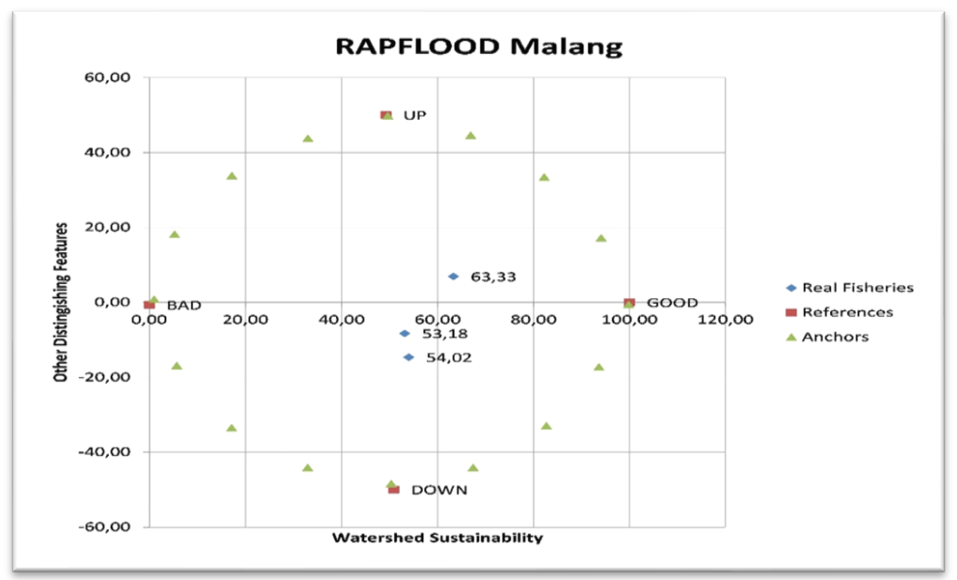
Figure 3.
Illustrates the several factors that influence the Ecological Dimension.
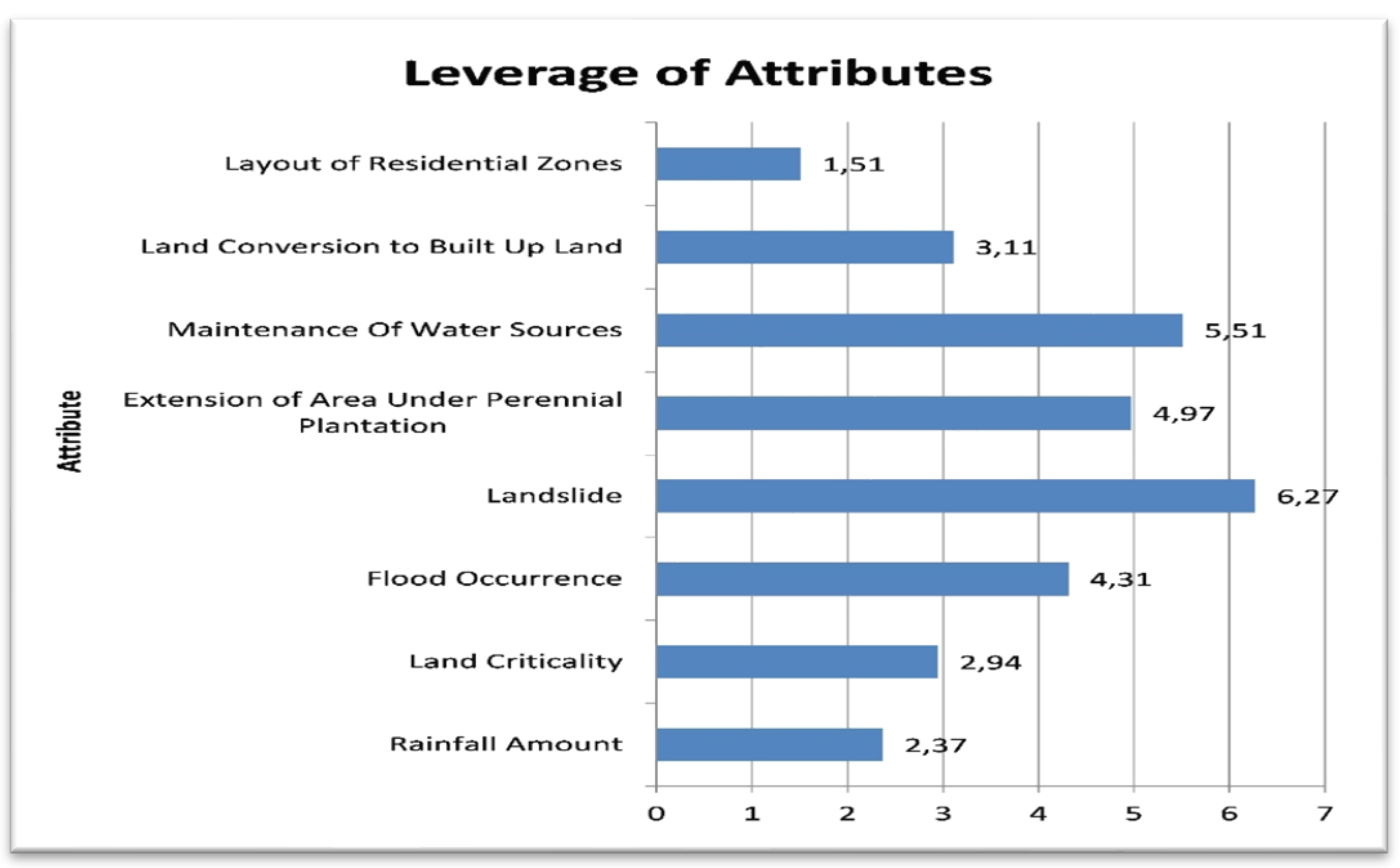
Table 2.
Factors affecting the sustainability of Ambang Watershed Management.
| No | Leverage Factors | RMS | |
|---|---|---|---|
|
1 2 3 4 5 |
Landslide Maintenance Of Water Resources Extension of Area under Perennial Plantation Flood Occurence Land Conversion to Build Up Land |
6,27 5,51 4,97 4,31 3,11 |
Table 3.
Sustainability value (MDS and Monte Carlo).
| Dimension | Sub Watershed | Value of Sustainability Index | MDS-MC | |
|---|---|---|---|---|
| MDS | Monte Carlo | |||
| Ecology | Upstream Middlestream Downstream |
53,18 63,33 54,02 |
53,24 62,48 53,37 |
0,06 0,85 0,65 |
Disclaimer/Publisher’s Note: The statements, opinions and data contained in all publications are solely those of the individual author(s) and contributor(s) and not of MDPI and/or the editor(s). MDPI and/or the editor(s) disclaim responsibility for any injury to people or property resulting from any ideas, methods, instructions or products referred to in the content. |
© 2025 by the authors. Licensee MDPI, Basel, Switzerland. This article is an open access article distributed under the terms and conditions of the Creative Commons Attribution (CC BY) license (https://creativecommons.org/licenses/by/4.0/).
Copyright: This open access article is published under a Creative Commons CC BY 4.0 license, which permit the free download, distribution, and reuse, provided that the author and preprint are cited in any reuse.


